Embed Size (px)
Citation preview
UNEP
Report
December 2019
Strengthened drought and flood management through improved science-based information availability and management in Myanmar
Deliverable 7 (activity 3.1 and 3.2) Technical training session and closing workshop

dtie18-en015_final technical training and closing workshop.docx / 2019-12-03
This report has been prepared under the DHI Business Management System
certified by Bureau Veritas to comply with ISO 9001 (Quality Management)
Approved by
03-12-2019
X
Signed by: Oluf Zeilund Jessen

DHI A/S • Agern Allé 5 • • 2970 Hørsholm • Denmark Telephone: +45 4516 9200 • Telefax: +45 4516 9292 • [email protected] • www.dhigroup.com
Strengthened drought and flood management through improved science-based information availability and management in Myanmar
Deliverable 7 (activity 3.1 and 3.2) Technical training session and closing workshop
Prepared for UNEP
Represented by Ms Jaime Revenaz-Webbe
Project manager Sílvia Leirião
Quality supervisor Hans Christian Ammentorp
Prepared by Sílvia Leirião and Nisha Gill Hansted
Project number 11820065
Approval date 03 December 2019
Revision Final 2.0
Classification Open

dtie18-en015_final technical training and closing workshop.docx / 2019-12-03

i
EXECUTIVE SUMMARY
This report is Deliverable 7 of Activities 3.1 and 3.2 of the Climate Technology Centre and
Network (CTCN) technical assistance to Myanmar entitled ‘Strengthened drought and flood
management through improved science-based information availability and management’
(reference number 2016000035). It is funded by Green Climate Fund (GCF) Readiness and
Preparatory Support Funding. This technical assistance is implemented by DHI in cooperation
with the Climate Change Division of the Environmental Conservation Department (ECD),
Ministry of Natural Resources and Environmental Conservation (MONREC). The ECD is the
National Designated Authority (NDA) of the GCF as well as the National Designated Entity
(NDE) of the CTCN.
A web portal developed by DHI provides access to state-of-the-art remote sensing data and
information, tools and reporting abilities for flood and drought management, water resources and
water related sectors in Myanmar. The portal address is:
www.flooddroughtmonitor.com/myanmar
More information can be found in the “Technology specifications and methodology for validation”
report (Deliverable 3 of Activity 1.3) as well as “Technical training session and Validation report”
(Deliverable 5 of Activity 2.2). DHI will keep the system running for the period of 5 years and is
responsible for its maintenance.
This deliverable is documenting the final technical training session and official closing workshop
of this CTCN technical assistance to Myanmar, which took place from 26th to the 29th of August
2019.
This technical assistance will come to an end with the final deliverable of Activity 3, the Lessons-
learned and Roadmap report, including recommendations for further development of the portal,
for linkages with national policy development, and informing the design of a Draft GCF Concept
Note to upscale this project’s outcomes.

ii DTIE18-EN015_Final technical training and closing workshop.docx / 2019-12-03

iii
CONTENTS
1 Background ................................................................................................................. 1
2 Official Closing Ceremony .......................................................................................... 2
3 Final technical training ............................................................................................... 4 3.1 Validation conclusions ................................................................................................................... 4 3.2 Reporting application ..................................................................................................................... 5 3.3 Drought Assessment application ................................................................................................... 8 3.4 Draft Concept Note proposal ....................................................................................................... 10 3.5 Feedback from participants .......................................................................................................... 15
4 Concept Note Workshop ........................................................................................... 17
5 Project closure reporting .......................................................................................... 19
APPENDICES
APPENDIX A Opening Speech of Union Minister of MONREC
APPENDIX B Reports produced by participants
APPENDIX C Agendas
APPENDIX D Attendance Registers
FIGURES Figure 2.1 Union Minister of MONREC U Ohn Win and DHI Senior Specialist and Director of AIRBM
project Hans Christian Ammentorp, during official opening remarks. ............................................ 2 Figure 2.2 Union Minister of MONREC sitting in the foreground of the top photograph of the official
closing workshop, Director General of the ECD U Hla Maung Thein next to DHI Specialist
Hans Christian Ammentorp; On the bottom picture the remaining Director Generals of the
Ministry. .......................................................................................................................................... 3 Figure 3.1 Home page of the portal, the Reporting and Drought Assessment applications highlighted
in red. ............................................................................................................................................. 4 Figure 3.2 Reporting template and final report ............................................................................................... 6 Figure 3.3 Basic functionality within the Reporting application. Note that some functionalities are only
available when the user is the owner of the report. ....................................................................... 6 Figure 3.4 Example of a report containing 3 possible tag items: table, map and chart. ................................. 7 Figure 3.5 Groupwork presentations after the Reporting Tool hands-on exercises. ...................................... 8 Figure 3.6 Diagram of risk assessment workflow presented to participants. .................................................. 9 Figure 3.7 Participants working during the drought assessment application exercise. .................................. 9 Figure 3.8 Discussion and presentation of groupwork results on the draft Concept Note regarding
future project components. .......................................................................................................... 10

iv DTIE18-EN015_Final technical training and closing workshop.docx / 2019-12-03
Figure 3.9 Last Concept Note exercise, participants discuss ground interventions in the three climate
vulnerable States/Regions: mountainous, delta/flood-prone and dry zone. ................................ 11 Figure 4.1 Steps in the submission and subsequent approval of a project proposal by the GCF. ............... 17
TABLES Table 3.1 Record of the Dry Zone group presentation regarding question 1 .............................................. 11 Table 3.2 Record of the Mountainous Area group presentation regarding question 1 ................................ 12 Table 3.3 Record of the Delta/Flood-prone Area group presentation regarding question 1 ....................... 13 Table 3.4 Group answers to question 2 ....................................................................................................... 14 Table 3.5 Summary of findings from participants’ training evaluation. ........................................................ 16
ACRONYMS & ABBREVIATIONS
CHIRPS Climate Hazards Group Infrared Precipitation with Station
CTCN Climate Technology Centre & Network
DDM Department of Disaster Management
DHI www.dhigroup.com
DMH Department of Meteorology and Hydrology
DSS Decision Support System
DZGD Dry Zone Greening Department
ECD Environmental Conservation Department
GCF Green Climate Fund
GHG Green House Gases
GPM Global Precipitation Measurement
HAII Hydro and Agro Informatics Institute of Thailand.
HIC Hydro Informatics Center of Myanmar
IWUMD Irrigation and Water Utilization Management Department
MAD Mean Absolute Deviation
MAE Mean Absolute Error
MIID Myanmar Institute for Integrated Development
MIMU Myanmar Information Management Unit
MOALI Ministry of Agriculture Livestock and Irrigation
MOC Ministry of Construction
MOEE Ministry of Electricity and Energy
MONREC Ministry of Natural Resources and Environmental Conservation
MOTC Ministry of Transport and Communication
MSWRR Ministry of Social Welfare, Relief and Resettlement
NDA National Designated Authority
NDE National Designated Entity
NDVI Normalized Difference Vegetation Index
SAP Simplified Approval Process
SPI Standardized Precipitation Index
SPI1 Standardized Precipitation Index over 1 month period
SPI3 Standardized Precipitation Index over 3 months period
SPI6 Standardized Precipitation Index over 6 months period
SWI Soil Water Index
TRMM Tropical Rainfall Measuring Mission
WCRP World Climate Research Programme

Background
1
1 Background
This report is the Deliverable 7 of Activities 3.1 and 3.2 of the Climate Technology Centre and
Network (CTCN) technical assistance to Myanmar entitled ‘Strengthened drought and flood
management through improved science-based information availability and management’
(reference number 2016000035). It is funded by Green Climate Fund (GCF) Readiness and
Preparatory Support Funding.
This technical assistance is implemented by DHI in cooperation with the Climate Change
Division of the Environmental Conservation Department (ECD), Ministry of Natural Resources
and Environmental Conservation (MONREC). The ECD is the National Designated Authority
(NDA) of the GCF as well as the National Designated Entity (NDE) of the CTCN.
A web portal developed by DHI has been set up for Myanmar providing free and easy access to
data and information for flood and drought management, water resources and water related
sectors (www.flooddroughtmonitor.com). DHI will keep the system running for the period of 5
years and is responsible for its maintenance.
The activities focus on workshops and training, validating selected datasets of the web-portal,
generating a strong user community, and providing guidance to the ECD and other stakeholders
for the drafting of a GCF Simplified Approval Process (SAP) Concept Note for upscaling of the
outcomes of the technical assistance including installation of the portal in Myanmar.
The purpose of this report is threefold:
- To document the official closing ceremony with the presence of the Union Minister of
MONREC U Ohn Win and the Director General of the ECD U Hla Maung Thein;
- To document the final 3-day technical training that took place from the 26th to the 28th of
August 2019 in Nay Pyi Taw.
- To present the results from the final draft Concept Note workshop with MONREC and
MOALI.
2 DTIE18-EN015_Final technical training and closing workshop.docx / 2019-12-03
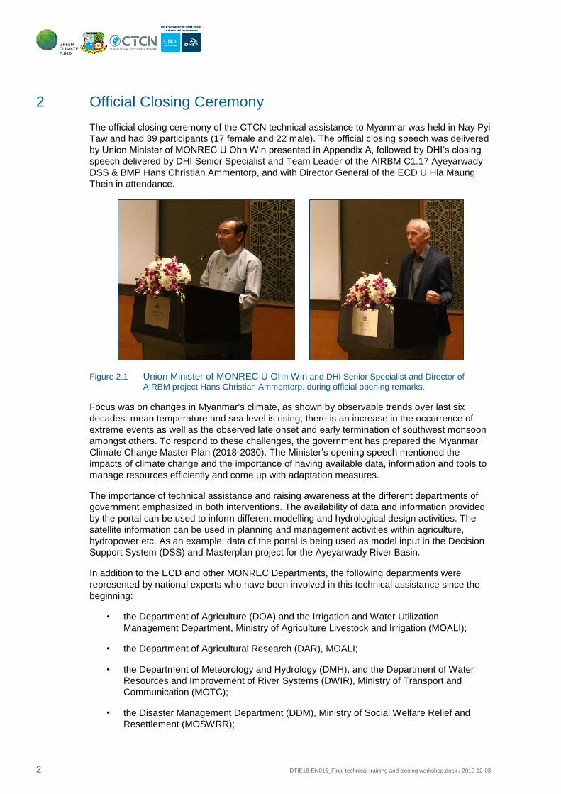
2 Official Closing Ceremony
The official closing ceremony of the CTCN technical assistance to Myanmar was held in Nay Pyi
Taw and had 39 participants (17 female and 22 male). The official closing speech was delivered
by Union Minister of MONREC U Ohn Win presented in Appendix A, followed by DHI’s closing
speech delivered by DHI Senior Specialist and Team Leader of the AIRBM C1.17 Ayeyarwady
DSS & BMP Hans Christian Ammentorp, and with Director General of the ECD U Hla Maung
Thein in attendance.
Figure 2.1 Union Minister of MONREC U Ohn Win and DHI Senior Specialist and Director of
AIRBM project Hans Christian Ammentorp, during official opening remarks.
Focus was on changes in Myanmar's climate, as shown by observable trends over last six
decades: mean temperature and sea level is rising; there is an increase in the occurrence of
extreme events as well as the observed late onset and early termination of southwest monsoon
amongst others. To respond to these challenges, the government has prepared the Myanmar
Climate Change Master Plan (2018-2030). The Minister’s opening speech mentioned the
impacts of climate change and the importance of having available data, information and tools to
manage resources efficiently and come up with adaptation measures.
The importance of technical assistance and raising awareness at the different departments of
government emphasized in both interventions. The availability of data and information provided
by the portal can be used to inform different modelling and hydrological design activities. The
satellite information can be used in planning and management activities within agriculture,
hydropower etc. As an example, data of the portal is being used as model input in the Decision
Support System (DSS) and Masterplan project for the Ayeyarwady River Basin.
In addition to the ECD and other MONREC Departments, the following departments were
represented by national experts who have been involved in this technical assistance since the
beginning:
• the Department of Agriculture (DOA) and the Irrigation and Water Utilization
Management Department, Ministry of Agriculture Livestock and Irrigation (MOALI);
• the Department of Agricultural Research (DAR), MOALI;
• the Department of Meteorology and Hydrology (DMH), and the Department of Water
Resources and Improvement of River Systems (DWIR), Ministry of Transport and
Communication (MOTC);
• the Disaster Management Department (DDM), Ministry of Social Welfare Relief and
Resettlement (MOSWRR);

Official Closing Ceremony
3
• the Hydro-Informatics Center.
The national media was also present namely MRTV and SkyNet broadcasters, covering the first
day of the technical training. More information on attendance and participant feedback and
evaluation can be found in chapter 3.5 and Appendix C and D.
Figure 2.2 Union Minister of MONREC sitting in the foreground of the top photograph of the official closing workshop, Director General of the ECD U Hla Maung Thein next to DHI Specialist Hans Christian Ammentorp; On the bottom picture the remaining Director Generals of the
Ministry.

4 DTIE18-EN015_Final technical training and closing workshop.docx / 2019-12-03
3 Final technical training
The final technical training of this assistance was initiated after the official closing ceremony on
the 26th of August until the 28th of August 2019. In attendance remained the technical national
experts from most departments. Agendas and attendance registers are given in Appendix C and
D respectively.
In this chapter, we report on the topics covered during the technical training, namely,
presentation of validation conclusions, the Reporting and Drought Assessment applications. The
portal address is: www.flooddroughtmonitor.com/myanmar, a screenshot of the homepage is
shown in Figure 3.1.
Figure 3.1 Home page of the portal, the Reporting and Drought Assessment applications highlighted in
red.
The specific objectives of the final training session were:
• to inform on the status of the ongoing CTCN technical assistance and the draft
Concept Note proposal being prepared for submission to the GCF;
• to continue to train technical specialists in use of the portal, from national
institutions in Myanmar, within the flood and drought, water resources and
disaster management framework;
• to receive feedback from participants on their use of the portal and application of
the data carried out in their own tasks.
This was the last event of the technical assistance that ended on the 31st of August 2019.
3.1 Validation conclusions
The results of the validation section of the technical assistance were revisited and additional
final conclusions presented to participants. For more information please see Deliverable 5
(activity 2.2) Technical training session and Validation report. A brief summary is listed below:
1. The study areas were selected based on two categories; flood and drought. According to
the information from stakeholders and historical records, the lower part of Myanmar
especially in Bago, Kayin and Mon state represent flooded areas while the central dry zone
of Myanmar represent a drought-affected area.

Final technical training
5
2. In statistical validation of satellite data, percentage difference and R-square values
represent ‘all dataset are in good correlation’ while MAE and MAD represent the deviation
of each dataset. Although compared dataset provide a high correlation, each dataset still
has high uncertainty.
3. By comparing with observed rainfall data in five stations it was found that the satellite
rainfall data has a similar pattern on a monthly basis. High rainfall events were not well
described however. CHIRPS has the smallest resolution, long period dataset, but high
uncertainty whereas TRMM has largest resolution and high uncertainty. GPM is an
improved product from TRMM. It has smaller resolution, but very high uncertainty.
4. It was found that SPI and SWI have a good correlation in the rainy season at Mandalay and
Myingyan. Also for NDVI, SPI values are positively correlated during the rainy season and
can indicate where rainfed agriculture may be facing problems. NDVI also correlates well
with the high vegetation activity in July and August (Rainy Season) and low activity in
March and April (summer) in Myanmar.
5. The occurrence of drought can be detected using the SPI index, which is negative for
unusually low rainfall. This can also be validated against information on damaged planted
areas, which is collected by the DOA.
6. SPI provides an indication of meteorological drought. In order to establish a direct
correspondence between the SPI and the NDVI deficit and verify the influence of the
drought conditions on vegetation, more data is needed. Our approach was to inspect the
portal’s Crop Calendar and select those time periods for NDVI deficit and SWI percentile
datasets and calculate the correlation with SPI. The results indicate that correlation is more
pronounced, when it is informed by selected time windows.
7. An objective of the portal is to provide a better understanding of the climate at regional and
national scale. Using remote sensing data can be relevant – even when deviating from data
at specific locations/stations – particularly in areas with low coverage of stations. In
addition, rainfall estimates from remote sensing at a large catchment scale might be more
accurate than from single stations. Finally, continuous bias in rainfall data will not influence
the results of indices such as SPI, as relative variations are assessed.
3.2 Reporting application
The two days of the technical training were mostly spent on the Reporting application of the
portal, where stakeholders learned the basic functionality and how reports were developed. The
specific objectives of this application are to:
• Configure reports for dissemination of results, warnings or information
• Have a flexible system allowing the user to configure and tailor reports
• Provide facility for automation of a reporting task based on schedule or trigger event
The outputs are user-configured reports and automated submitted warnings. This application
was built to respond to the need for tools to disseminate data reports that are automatically
maintained up-to-date. Additionally, the user can set a frequency in days for emailing the report
automatically.
In the individual and group exercises, stakeholders learned how to view an existing report, clone
an existing report, change some items and generate a report.
The reporting application is based on reporting templates (Word documents) containing a
number of tags, where the user is able to specify which type of content the reporting application

6 DTIE18-EN015_Final technical training and closing workshop.docx / 2019-12-03
should replace the tags with. Currently the tags can be replaced with images, text, charts or
tables.
Figure 3.2 Reporting template and final report
In the reporting application, after uploading the template the same tags as set up in the template
report are listed in the table view of the app. The text between the brackets in the template
report is shown in the “Tag” column. Figure 3.3 shows a screenshot of a template being edited
inside the Reporting application as well as a description of the functionality.
Figure 3.3 Basic functionality within the Reporting application. Note that some functionalities are only
available when the user is the owner of the report.
To Download the full report as PDF or Word document, the user needs to first Generate the
report:
• Preview is used by the owner of the report to see the report while it is been configured.
Only the owner of the report is able to preview a report
Template report with tags
Final report with input

Final technical training
7
• Generate is used by the owner to publish the report so all users accessing the same
workgroup can view or download the report.
When working in the private workgroup, these functions do not make any difference since only
one user (the owner) has access to the workgroup. Once the report has been generated, the
report made available for download from the public link is also updated.
An exercise followed on how to access favourite data from the Data and Information application
and include it in a report.
The last exercise on the reporting application showed the participants how to create a new
report from scratch, and how to publish the report.
Participants were divided in groups of three, and each group received an area of interest and a
climate change burning issue and asked to build a report on it using the Reporting application.
They were to think of a title, body of text and data needed for their analysis.
In each report, groups added placeholders for items that should be replaced by the Reporting
app, writing these using {} as mentioned previously, as well as descriptive text for the tags so
they will be easier to identify within the Reporting app (see below example).
Figure 3.4 Example of a report containing 3 possible tag items: table, map and chart.
After building their reports and before sharing them, users need to Generate it. This will make it
accessible to other users via a link for example. They could copy the public link and send it to
the instructor via email. All reports produced by stakeholders are included in Appendix B.
8 DTIE18-EN015_Final technical training and closing workshop.docx / 2019-12-03
Figure 3.5 Groupwork presentations after the Reporting Tool hands-on exercises.
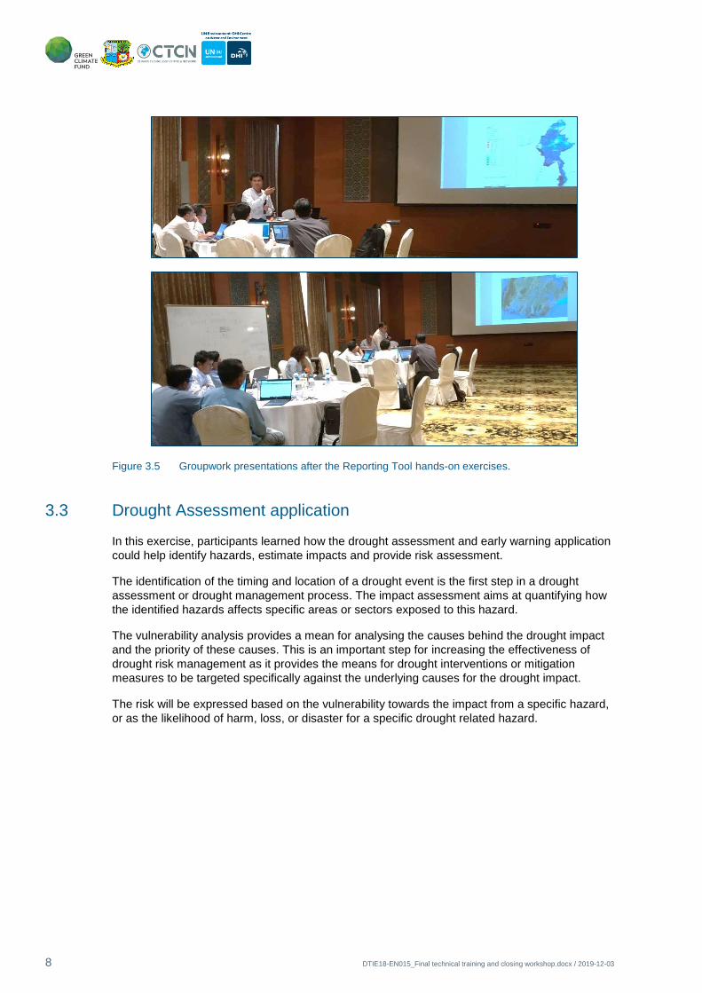
3.3 Drought Assessment application
In this exercise, participants learned how the drought assessment and early warning application
could help identify hazards, estimate impacts and provide risk assessment.
The identification of the timing and location of a drought event is the first step in a drought
assessment or drought management process. The impact assessment aims at quantifying how
the identified hazards affects specific areas or sectors exposed to this hazard.
The vulnerability analysis provides a mean for analysing the causes behind the drought impact
and the priority of these causes. This is an important step for increasing the effectiveness of
drought risk management as it provides the means for drought interventions or mitigation
measures to be targeted specifically against the underlying causes for the drought impact.
The risk will be expressed based on the vulnerability towards the impact from a specific hazard,
or as the likelihood of harm, loss, or disaster for a specific drought related hazard.

Final technical training
9
Figure 3.6 Diagram of risk assessment workflow presented to participants.
The Drought Assessment application is made to provide early warning in the “Warning” tab and
perform risk analysis in the “Risk” tab. “Warning” and “Hazard” layers play different roles: in the
former, to try to anticipate lack of rain/potential for drought; whereas in the latter it has meaning
if it occurs over a vulnerable area, because then an assessment on the level of risk for that area
can be made.
Drought warnings rely on the categorized drought indices and a locally determined warning
threshold expressed as a lower or upper threshold for the index value and a duration.
Figure 3.7 Participants working during the drought assessment application exercise.
The threshold values are used to identify if there is a potential hazard based on warning or
drought indicators exceeding a specific threshold. This could be accumulated rainfall amount
within a month being below a specific value, number of consecutive dry days in a month being
above a specific threshold, or number of days where a drought index e.g. SPI is below a specific
threshold. In order to use the warning layers for actual drought early warning it is required that

10 DTIE18-EN015_Final technical training and closing workshop.docx / 2019-12-03
the threshold values are adjusted or “calibrated” towards the local conditions. This will often be
done using the following steps:
• Selection of the warning layer to use, e.g. accumulated rainfall in the last 30 days
• Evaluation if the selected warning layer provides a “significant” description of the
selected drought event. In other words, consideration is given to whether it is possible to
detect the drought event based on this data type.
• If this is the case, then follows the determination of a threshold value which was relevant
for the selected event and evaluate if the same threshold should be applied for future
events or if there are factors which could influence the threshold.
In the Risk assessment exercise, participants used a combination of Hazard layers and
Vulnerability layers. The Hazard layers are like the layers available in the Warning tab. The
Vulnerability layers are mainly socio-economic or agriculture related layers. They identified in
their areas of interest locations at different severity levels of risk of drought.
3.4 Draft Concept Note proposal
The last session of the technical training was dedicated to the draft Concept Note proposal
being prepared currently under ECD’s coordination. The status of the proposal was presented to
all stakeholders. A brainstorming exercise was carried out where participants were placed into
multi-institution groups, assigned a focus area and asked two questions regarding issues and
interventions of the future project in the climate vulnerable areas of Myanmar.
Figure 3.8 Discussion and presentation of groupwork results on the draft Concept Note regarding future project components.

Final technical training
11
A similar exercise was carried out during the very first workshop of this technical assistance, for
more information see “Deliverable 2 (activity 1.2) Workshop report and cases for validation”,
where participants used the Issue Analysis application in the portal to carry out a rapid water
resources assessment of environmental issues. At this final workshop, building on all the portal
experience they have accumulated, they were asked to do a similar analysis, having in mind
their feedback would support Executing Entities in compiling a proposal for a future project.
However, focus was placed on Pakkoku, Labutta and Hakha townships specifically as examples
of delta/flood-prone area, dry zone and mountainous region communities that are very
vulnerable to the impacts of climate change. The results of Climate Change Vulnerability
Assessment reports were presented to all stakeholders before carrying out discussions. Next,
they were asked to respond to the following questions:
1. How are the livelihoods of vulnerable communities directly impacted by climate hazards and
climate change?
2. What actions that can be implemented on the ground, solve the issues, and how could the
future system (portal remote sensing data/tools) support this?
Figure 3.9 Last Concept Note exercise, participants discuss ground interventions in the three climate vulnerable States/Regions: mountainous, delta/flood-prone and dry zone.
The following table gathers the responses from each group where impacts are aggregated in
four categories: impacts on water resources and supply, impacts on health, income and
economy and the environment.
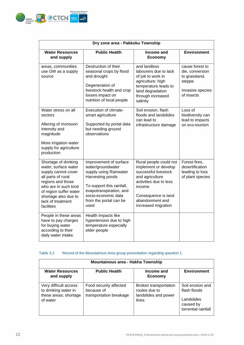
Table 3.1 Record of the Dry Zone group presentation regarding question 1
Dry zone area - Pakkoku Township
Water Resources
and supply
Public Health Income and
Economy
Environment
Lowering
groundwater table
(storage), very
serious in many rural
Heat stroke can impact
human health
Delaying the cropping
harvest time and crop
loss: it can affect
income of farmers;
Forest cover
impacted due to
extreme drought
and flood; it can
12 DTIE18-EN015_Final technical training and closing workshop.docx / 2019-12-03
Dry zone area - Pakkoku Township
Water Resources
and supply
Public Health Income and
Economy
Environment
areas, communities
use GW as a supply
source
Destruction of their
seasonal crops by flood
and drought
Degeneration of
livestock health and crop
losses impact on
nutrition of local people
and landless
labourers due to lack
of job to work in
agriculture; high
temperature leads to
land degradation
through increased
salinity
cause forest to
die, conversion
to grassland,
steppe
Invasive species
of insects
Water stress on all
sectors
Altering of monsoon
intensity and
magnitude
More irrigation water
supply for agriculture
production
Execution of climate-
smart agriculture
Supported by portal data
but needing ground
observations
Soil erosion, flash
floods and landslides
can lead to
infrastructure damage
Loss of
biodiversity can
lead to impacts
on eco-tourism
Shortage of drinking
water; surface water
supply cannot cover
all parts of rural
regions and those
who are in such kind
of region suffer water
shortage also due to
lack of treatment
facilities
Improvement of surface
water/groundwater
supply using Rainwater
Harvesting ponds
To support this rainfall,
evapotranspiration, and
socio-economic data
from the portal can be
used
Rural people could not
implement or develop
successful livestock
and agriculture
activities due to less
income
Consequence is land
abandonment and
increased migration
Forest fires,
desertification
leading to loss
of plant species
People in these areas
have to pay charges
for buying water
according to their
daily water intake.
Health impacts like
hypertension due to high
temperature especially
elder people
Table 3.2 Record of the Mountainous Area group presentation regarding question 1
Mountainous area - Hakha Township
Water Resources
and supply
Public Health Income and
Economy
Environment
Very difficult access
to drinking water in
these areas; shortage
of water
Food security affected
because of
transportation breakage
Broken transportation
routes due to
landslides and power
lines
Soil erosion and
flash floods
Landslides
caused by
torrential rainfall

Final technical training
13
Mountainous area - Hakha Township
Water Resources
and supply
Public Health Income and
Economy
Environment
Loss of lives due to flash
flood and to lack of
adaptive capacity and
awareness
Loss of property due
to flash flood and to
lack of adaptive
capacity and
awareness
Wild animals
are becoming
endangered due
to impacts of
flooding
Malnutrition of local
people
Declining crop yield
and farmers’ income
due to erratic climate
pattern
Failure in
communications
impacts local
businesses
Higher commodity
prices due to poor
commodity flow and
lack of access to basic
services
Table 3.3 Record of the Delta/Flood-prone Area group presentation regarding question 1
Delta/Flood-prone area - Labutta Township
Water Resources
and supply
Public Health Income and
Economy
Environment
Lack of access to
drinking water; fresh
water shortage, due
to salt water intrusion
Damage to seasonal
crops;
Decrease of agricultural
land area
Storms, wind and
heavy rain affect
commodity flow
Seawater intrusion
leads to land
degradation and
agricultural yield
reduction
Damages to
ecosystem and
coral reefs
Rice planting will be
delayed when there
is little rain;
Water and food
insecurity
Infrastructure
destruction
Increased rates
of coastal
erosion due to
sea level rise
Water supply
structure in need of
rehabilitation, not
enough treatment
facilities since
colonial time
Saline groundwater can
cause health impacts to
local people unless they
are aware of it, it may
lead to income reduction
due to health expenses
on recovery
Because of sea level
rise in delta areas,
there is loss of
agricultural land

14 DTIE18-EN015_Final technical training and closing workshop.docx / 2019-12-03
Delta/Flood-prone area - Labutta Township
Water Resources
and supply
Public Health Income and
Economy
Environment
Impact of floods in
education, as children
cannot go to school
When storm surges
occur, fishermen
cannot go to sea,
impacting their daily
income
The next table gathers each group’s response to question 2, organized in two sections: climate
change impacts and potential solutions including support by the portal.
Table 3.4 Group answers to question 2
Delta/Flood-prone area
Labutta Township
Dry zone area
Pakkoku Township
Mountainous area
Hakha Township
Salinity intrusion
Interventions:
Monitoring system on salinity
intrusion; development of
saline front map (rack salinity
intrusion, how much the front
advances from year to year)
Flood risk mapping; estimate
flooding and scope of flood
damage; prepare for early
warning; prepare to provide
seeds and food;
Breed resistant varieties,
change sowing time
Crop suitability map; soil
quality map
Increased drought frequency
and severity
Interventions:
Early Warning System,
dissemination through
TV/Media/FM; mobile sms;
mobile app (Myanmar
language)
Input data from the portal
could be used, inspiration in
Drought Assessment
application
Implementation on the
ground; infrastructure
improvement
Interventions:
Capacity building and
awareness raising
Technical assistance on
ground implementations
Need for clarity on drought
problems, estimate the
workload and plan to solve
the drought problem
Intervention:
Using the portal or decision
support system
Execution of climate-smart
agriculture
Interventions:
A mobile app for farmers;
Supported by the crop
calendar and regional
weather forecast in the
background programming of
this app; it can help them
solve their daily crop water
requirement problems
No climate change resilience
and crop type information;
need for Finding natural
water resources
Interventions:
Supported by the portal input
data and models; Suitability
of agricultural land; Suitable
route for transportation
access

Final technical training
15
Delta/Flood-prone area
Labutta Township
Dry zone area
Pakkoku Township
Mountainous area
Hakha Township
Supported by portal data but
needing ground observations
Impact on education, close
schools due to flooding and
storms
Interventions:
Support from portal:
indicators for decision
makes, Issue Analysis as
education tool
Improvement of surface
water/groundwater supply
using Rainwater Harvesting
ponds
Interventions:
To support this rainfall,
evapotranspiration, and
socio-economic data from the
portal can be used
Soil stability is an issue, so
they need to know what to
plant
Interventions:
Soil conservation zoning;
crop suitability maps
Environmental land
degradation; water scarcity
due to degraded quality;
deforestation
Interventions:
Capacity building targeting
lack of awareness, change of
mindset of
inhabitants/government and
stronger regulation;
Support by portal education
tools and on site training
Drinking water infrastructure,
road infrastructure how to
build and where
Interventions:
Enhancing technical
assistance provision using
the Masterplan
3.5 Feedback from participants
The training was held in Nay Pyi Taw and had 20 participants. All filled out the evaluation form.
The overall impression of the workshop was very good, with 95% of participants finding it good
or excellent, and only 5% (one person) finding it average. The topic that most participants found
most interesting is the reporting app, where 10 respondents mention this as one of the most
interesting topics for them. Second comes the response “all topics were interesting”, which is
stated by five participants. Both the drought assessment and data and information are
mentioned by three participants each.
12 people would recommend the course to others while 5 would not. The remaining three did
not answer. However, some of the participants who would not recommend the workshop still
rate it as excellent and one of the persons describes it as “the perfect workshop” in the
comments. Therefore, it is clear that not recommending the workshop does not (in all cases)
correspond to a negative impression of the workshop. It is possible that the respondents simply
do not think the workshop would be relevant for anyone else. The same issue has possibly been
identified before, so it could be relevant to have another question related to why the respondents
choose what they do, in order to better understand the responses.

16 DTIE18-EN015_Final technical training and closing workshop.docx / 2019-12-03
For the course content, as seen below, respondents choose Strongly agree or Agree for all
topics, except for the last – “The Myanmar Flood & Drought Portal will be helpful in my day to
day activities”. For this topic, 7 people, corresponding to 35%, choose Neither/nor or Disagree.
Table 3.5 Summary of findings from participants’ training evaluation.
For questions regarding workshop execution and workshop practicalities, the distribution is quite
similar for most questions, with 15-35% choosing Strongly agree and 65-75% choosing Agree. A
few (1-2) choose neither/nor for most questions.
In Workshop execution, the point that performed best was “Instructor(s) had a good knowledge
and understanding of the subject”. Participants were least happy with the duration of the course.
For the workshop practicalities, participants were most happy with the venue and least happy
with how long advance they received practical information.
Regarding the comments, participants generally seem very satisfied, using phrases like “perfect
workshop” and “one of the best workshops I have attended” and asking for more, similar
workshops. Some comments are more critical; one mentions a bug in the portal that needs to be
fixed and one other calls for a good translator.
Some comments ask for more knowledge and training, regarding the portal itself, the flood and
drought project, and what data should be used as inputs to the portal.
One comment particularly asks for more participants from different private and public sectors.
These should then express their suggestions, impressions and future perspectives regarding the
portal to other participants.

Concept Note Workshop
17
4 Concept Note Workshop
On the 29th of August 2019, the last draft Concept Note Workshop was held in Nay Pyi Taw, the
agenda and attendance register are in Appendix C and D respectively. Participants were
stakeholders from the ECD, DOA and DAR.
The session started out with revisiting the submission process and following steps, including the
submission and approval of the funding proposal until the project implementation (see Figure
4.1).
Figure 4.1 Steps in the submission and subsequent approval of a project proposal by the GCF.
Participants received printed copies of the current draft of the Concept Note and project
logframe. They started by reviewing it considering comments from GCF water experts as well as
DHI’s water resources specialists:
• Component 2 activities: larger emphasis on activities with direct impact on most
vulnerable communities, direct impact on livelihood improvement.
• Inclusion of more tangible Integrated Water Resources Management output.
• The GCF looks for strategic solution ideas instead of standalone investments, as well as
proposals for projects implementing best options verified in feasibility studies.
• Proposals of projects using a wider range of financial instruments and with verified
ability to pay Operation & Maintenance costs are very well positioned.
• An evaluator may get the impression that the project would be good for ECD and other
Executing Entities, but think: how much it would actually benefit the people of
Myanmar?
• More focus on the problems that are possible to address, and how this will be done:
o The location and severity of increased stress on rainfed agriculture, caused by
CC, will be predicted changes in the impact of floods and droughts on people
and property will be predicted (where, severity)
o Describing how the project/ECD/other partners will ensure early action to
mitigate such foreseen problems.

18 DTIE18-EN015_Final technical training and closing workshop.docx / 2019-12-03
• The evaluator may also ask to which extent the current portal and the currently trained
users can provide these benefits.
• Set up a realistic budget, including all participating Myanmar organisations.
Next, we looked at an approved Concept Note available at the GCF website: “Empowering food
insecure and vulnerable communities through climate services and diversification of climate
sensitive livelihoods in the Kyrgyz Republic” from 15th June 2016. Here we studied how the GCF
investment criteria had been tackled and looked at its budget as an example.
Both the MOALI and the MONREC teams provided comments on each component and the
logframe of the project. The final draft to be presented in the last deliverable of this technical
assistance, will incorporate the product of these discussions. Main contributions regarding
needed project interventions in the climate vulnerable townships are listed below in general:
• Data collection on the ground for all three areas;
• ECD training center, land access and training activities definition.
As specific climate change adaptation interventions for the delta/flood-prone area of Labutta
Township, participants listed:
• Reclamation of saline soils;
• Organic fertilizer application;
• Restoration of mangroves;
• Testing salt tolerant rice varieties.
For the dry zone Pakkoku Township, the following interventions were considered:
• Early Warning System with data collected on the ground
• Application of water efficient technology
• Testing drought resistant varieties
• Application of rain water harvesting
• Application of soil and water conservation methods
• Crop diversification/agroforestry.
Regarding the mountainous Hakha Township:
• Procurement of satellite imagery with fine resolution;
• Application of sloping agriculture land technologies and agroforestry;
• Using water efficient technologies and organic fertilizers, survey of water tank
dimensions and locations, compare performance of water tanks;
• Develop methodology for processing of images to produce potential landslide maps and
transport route maps;
• Soil type surveying.
Finally, the budgeting GCF spreadsheet downloaded from their website was also provided to
participants and each team took it as an example of how to put together the project budget. At
the end of the day, they agreed: that the IWUD would be asked to join as Executing Entity; that

Project closure reporting
19
each team would be available for remote iterations of the draft proposal document; and that they
would work on budgeting the relevant project activities within the logframe.
5 Project closure reporting
The last written deliverables of Activity 3 will be the Roadmap and lessons learned report,
describing recommendations for further development of the portal and for linkages with national
policy development and potential for engagement of the private sector.
Continued and close coordination with the Climate Change Division of the ECD will ensure the
Draft Concept Note is finalized with the support from this technical assistance. After that the
ECD and the NDA will be responsible for its submission.

20 DTIE18-EN015_Final technical training and closing workshop.docx / 2019-12-03

APPENDIX A
Opening Speech of Union Minister of MONREC

DTIE18-EN015_Final technical training and closing workshop.docx / 2019-12-03

Opening Speech of Union Minister of MONREC
A-1

A-2 DTIE18-EN015_Final technical training and closing workshop.docx / 2019-12-03

Opening Speech of Union Minister of MONREC
A-3

A-4 DTIE18-EN015_Final technical training and closing workshop.docx / 2019-12-03

Opening Speech of Union Minister of MONREC
A-5

A-6 DTIE18-EN015_Final technical training and closing workshop.docx / 2019-12-03

APPENDIX B
Reports produced by participants


Reports produced by participants
B-1

APPENDIX C
Agendas

DTIE18-EN015_Final technical training and closing workshop.docx / 2019-12-03
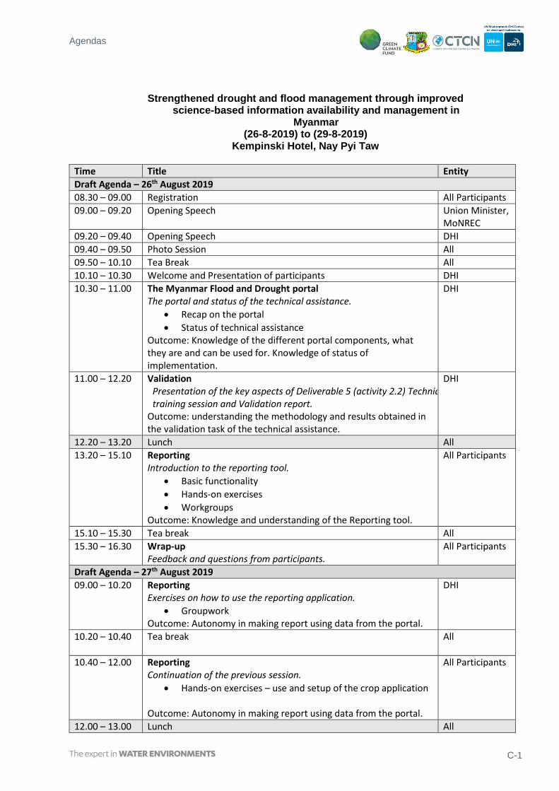
Agendas
C-1
Strengthened drought and flood management through improved science-based information availability and management in
Myanmar (26-8-2019) to (29-8-2019)
Kempinski Hotel, Nay Pyi Taw
Time Title Entity
Draft Agenda – 26th August 2019
08.30 – 09.00 Registration All Participants
09.00 – 09.20 Opening Speech Union Minister, MoNREC
09.20 – 09.40 Opening Speech DHI
09.40 – 09.50 Photo Session All
09.50 – 10.10 Tea Break All
10.10 – 10.30 Welcome and Presentation of participants DHI
10.30 – 11.00 The Myanmar Flood and Drought portal The portal and status of the technical assistance.
• Recap on the portal
• Status of technical assistance Outcome: Knowledge of the different portal components, what they are and can be used for. Knowledge of status of implementation.
DHI
11.00 – 12.20 Validation Presentation of the key aspects of Deliverable 5 (activity 2.2) Technical training session and Validation report.
Outcome: understanding the methodology and results obtained in the validation task of the technical assistance.
DHI
12.20 – 13.20 Lunch All
13.20 – 15.10 Reporting Introduction to the reporting tool.
• Basic functionality
• Hands-on exercises
• Workgroups Outcome: Knowledge and understanding of the Reporting tool.
All Participants
15.10 – 15.30 Tea break All
15.30 – 16.30 Wrap-up Feedback and questions from participants.
All Participants
Draft Agenda – 27th August 2019
09.00 – 10.20 Reporting Exercises on how to use the reporting application.
• Groupwork Outcome: Autonomy in making report using data from the portal.
DHI
10.20 – 10.40 Tea break
All
10.40 – 12.00 Reporting Continuation of the previous session.
• Hands-on exercises – use and setup of the crop application Outcome: Autonomy in making report using data from the portal.
All Participants
12.00 – 13.00 Lunch All

C-2 DTIE18-EN015_Final technical training and closing workshop.docx / 2019-12-03
13.00 – 15.00 Crop application Recap on the concepts underlying the crop model that could be used to forecast drought impact on crops. Include the uncertainty in the climate forecast in the assessment.
• Hands-on exercises – use and setup of the crop application
• Spatial input versus User-defined and Ensemble Outcome: Capacity and knowledge to evaluate the impact on the crop production from drought events.
All Participants
15.00 – 15.20 Tea break All
15.20 – 16.00 Wrap-up Feedback and questions from participants.

Agendas
C-3
Strengthened drought and flood management through improved science-based information availability and management in
Myanmar
(28-8-2019) to (29-8-2019)
Kempinski Hotel, Nay Pyi Taw
Draft Agenda- 28 th August
08.30 – 08.50 Technical assistance official closure
Director
General, ECD
08.50-09.20 Introduction to Concept Note
• Discussion of the Draft Concept Note and status
DHI
09.20-09.40 Awarding Certificates Ceremony
• Course Evaluation
• Awarding of Training Certificates
Director, ECD
Silvia
09.40 – 10.00 Tea break All
10.00 – 12.00 Wrap up
Presentation of the status of the sustainability of the outputs of the
technical assistance.
• Group work regarding climate vulnerable areas of Myanmar
• Final Q&A with participants about the portal applications
Outcome: Information to stakeholders regarding the future steps.
DHI
12.00 – 13.00 Lunch All
13.00 – 15.00 Status of the SAP Concept Note
Planning of next steps and GCF criteria. Expected project results aligned with the GCF investment criteria
DHI
&
ECD only
Draft Agenda- 29 th August
09.00 – 10.20 Status of the SAP Concept Note Section A Presentation of the SAP as reviewed by DHI. Review of the main project components and activities.
• Section A overview of key parameters Revision of the problem statement and climate rationale, objective and selected implementation approach.
ECD
&
DOA
10.20 – 10.40 Tea break All
10.40 – 12.00 SAP Concept Note Section B Project / Programme details Continue work on draft Concept Note.
• Context and Baseline Group work to review project components and activities for each component.
ECD
&
DOA
12.00 – 13.00 Lunch All
13.00 – 15.00 Next steps Planning of next steps and recap of the submission process to the GCF.
ECD
&
DOA

C-4 DTIE18-EN015_Final technical training and closing workshop.docx / 2019-12-03

APPENDIX D
Attendance Registers

DTIE18-EN015_Final technical training and closing workshop.docx / 2019-12-03
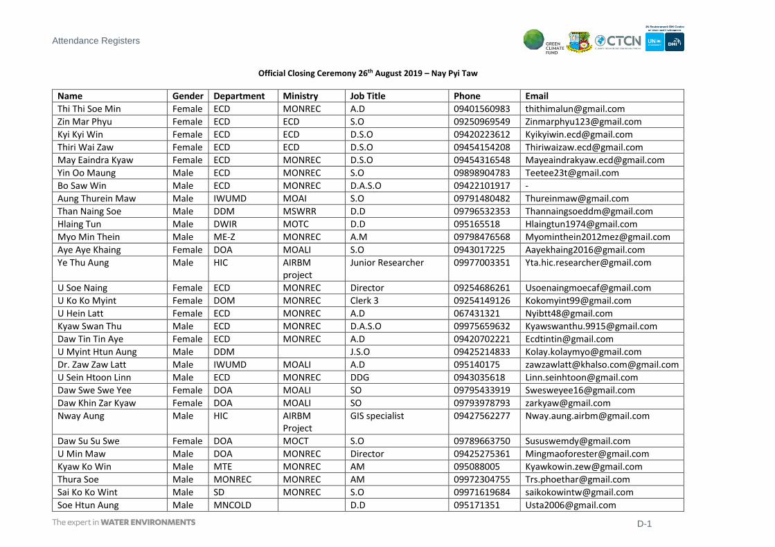
Attendance Registers
D-1
Official Closing Ceremony 26th August 2019 – Nay Pyi Taw
Name Gender Department Ministry Job Title Phone Email
Thi Thi Soe Min Female ECD MONREC A.D 09401560983 [email protected]
Zin Mar Phyu Female ECD ECD S.O 09250969549 [email protected]
Kyi Kyi Win Female ECD ECD D.S.O 09420223612 [email protected]
Thiri Wai Zaw Female ECD ECD D.S.O 09454154208 [email protected]
May Eaindra Kyaw Female ECD MONREC D.S.O 09454316548 [email protected]
Yin Oo Maung Male ECD MONREC S.O 09898904783 [email protected]
Bo Saw Win Male ECD MONREC D.A.S.O 09422101917 -
Aung Thurein Maw Male IWUMD MOAI S.O 09791480482 [email protected]
Than Naing Soe Male DDM MSWRR D.D 09796532353 [email protected]
Hlaing Tun Male DWIR MOTC D.D 095165518 [email protected]
Myo Min Thein Male ME-Z MONREC A.M 09798476568 [email protected]
Aye Aye Khaing Female DOA MOALI S.O 0943017225 [email protected]
Ye Thu Aung Male HIC AIRBM project
Junior Researcher 09977003351 [email protected]
U Soe Naing Female ECD MONREC Director 09254686261 [email protected]
U Ko Ko Myint Female DOM MONREC Clerk 3 09254149126 [email protected]
U Hein Latt Female ECD MONREC A.D 067431321 [email protected]
Kyaw Swan Thu Male ECD MONREC D.A.S.O 09975659632 [email protected]
Daw Tin Tin Aye Female ECD MONREC A.D 09420702221 [email protected]
U Myint Htun Aung Male DDM J.S.O 09425214833 [email protected]
Dr. Zaw Zaw Latt Male IWUMD MOALI A.D 095140175 [email protected]@gmail.com
U Sein Htoon Linn Male ECD MONREC DDG 0943035618 [email protected]
Daw Swe Swe Yee Female DOA MOALI SO 09795433919 [email protected]
Daw Khin Zar Kyaw Female DOA MOALI SO 09793978793 [email protected]
Nway Aung Male HIC AIRBM Project
GIS specialist 09427562277 [email protected]
Daw Su Su Swe Female DOA MOCT S.O 09789663750 [email protected]
U Min Maw Male DOA MONREC Director 09425275361 [email protected]
Kyaw Ko Win Male MTE MONREC AM 095088005 [email protected]
Thura Soe Male MONREC MONREC AM 09972304755 [email protected]
Sai Ko Ko Wint Male SD MONREC S.O 09971619684 [email protected]
Soe Htun Aung Male MNCOLD D.D 095171351 [email protected]

D-2 DTIE18-EN015_Final technical training and closing workshop.docx / 2019-12-03
Name Gender Department Ministry Job Title Phone Email
Dr. Hnin Phyu Phyu Aung Female ECD S.O 09777338222 Hninphyu2693
U Tain Moe Hlaing Male ECD 095060798
U Nanda Win Aung Male MONREC A.D 09420732868
U Hla Mg Thein Male ECD D.G 095060798
Daw Thida Myint Female DMH A.D 09250954645 [email protected]
Htet Naing Male MITV(media) 09420773460
Daw Swe Swe Than Female MRTV(media) 09252590158
Poe Au Female Skynet(media) 09898137828
U Min Thu Male MRTV(news) 09420089703
Sílvia Leirião Female DHI Project Manager +4550 333182 [email protected]
Bertrand Richaud Male DHI Water Resources Expert
+33240487447 [email protected]
Hans Christian Ammentorp
Male DHI Water Resources Expert

Attendance Registers
D-3
Technical training 26, 28 and 29th August 2019 – Nay Pyi Taw
Name Gender Department Ministry Job Title Phone Email
Daw Su Su Swe Female DMH MOTC S.O 09789663750 [email protected]
U Myint Htun Aung Male DDM Junior S.O 09425214833 [email protected]
U Ye Thu Aung Male HIC AIRBM project Junior Researcher 09977003351 [email protected]
U Soe Htun Aung Male IWUMD MOALI D.D 095171351 [email protected]
Daw Thi Thi Soe Min Female ECD MONREC A.D 09401560983 [email protected]
U Hlaing Tun Male DWIR MOTC D.D 095165518 [email protected]
Daw Khin Zar Kyaw Female DOA MOALI S.O 09793978793 [email protected]
U Kyaw Swan Thu Male CC MONREC D.S.O 09975659632 [email protected]
U Than Naing Soe Male DDM MSWRR DD 09796532353 [email protected]
U Nway Aung Male HIC AIRBM 09427562277 [email protected]
U Aung Thurein Maw Male IWUMD MOALI SO 09791480482 [email protected]
Daw Aye Aye Khaing Female DOA MOALI SO 0943017225 [email protected]
Daw Zin Mar Phyu Female ECD MONREC SO 09250969549 [email protected]
Daw Tin Tin Aye Female ECD MONREC AD 09420702221 [email protected]
U Hein Latt Male ECD MONREC AD 067431321 [email protected]
Daw Swe Swe Yee Female DOA MOALI SO 09795433919 [email protected]
Dr. Zaw Zaw Latt Male IWUMD MOALI AD 095140175 [email protected]
Dr. Hnin Phyu Phyu Aung Female ECD MONREC SO 09777338222 [email protected]

D-4 DTIE18-EN015_Final technical training and closing workshop.docx / 2019-12-03
Concept Note Workshop 29th August 2019 – Nay Pyi Taw
Name Gender Department Ministry Job Title Phone Email
Zin Mar Phyu Female ECD MONREC S.O 09250969549 [email protected]
Daw Tin Tin Aye Female ECD MONREC A.D 09420702221 [email protected]
Hein Latt Male ECD MONREC A.D 067431321 [email protected]
Swe Swe Yee Female DOA MOALI S.O 09795433919 [email protected]
Khin Zar Kyaw Female DOA MOALI S.O 09793978793 [email protected]
Aye Aye Khaing Female DOA MOALI S.O 0943017225 [email protected]
Hnin Phyu Phyu Aung Female ECD MONREC S.O 09777338222 [email protected]
Aung Kyaw Thu Male DAR MOALI A.R.O 09420700614 [email protected]