Embed Size (px)
Citation preview
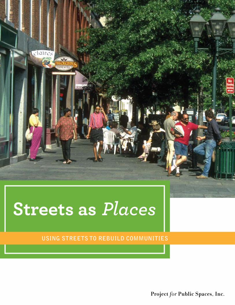
Using streets to rebUild CommUnities
Project for Public Spaces, Inc.
Streets as Places

Streets as PlacesProject for Public SPaceS, inc.
Photographs: Project for Public Spaces, Inc. (unless otherwise indicated)
Copyright © 2008, Project for Public Spaces, Inc.ISBN 978-0-970-63245-6 AARP D19126
This book was funded by:National Endowment for the ArtsAmerican Conservation AssociationThe Laura Jane Musser FundSurdna Foundation, Inc.Jules Rand, Inc.
Reprinted by: AARP
Project for Public Spaces700 Broadway, 4th FloorNew York, New York 10003P 212.620.5660 F 212.620.3821www.pps.org
I.
II.
III.
IV.
V.
VI.
VII.
VIII.
IX.
X.
Table of Contents
Acknowledgements iiPreface iii
Introduction: The Getting From Here To There Dilemma 1The Case of the Disappearing Place 5Valuable Lessons From the Past 13How to Create Great Places 23The Power of Traffic Calming 33The Transit Connection 47 Taking Action To Make Great Communities 53Taking Steps To Change Direction 65Finding the Money 75As the Journey Begins… 83
Appendices How to Organize and Facilitate a Community Meeting 89Glossary 92Photo and Illustration Credits 98 Sources and Resources 99
Acknowledgements
in addition to the organizations listed above that funded the research and preparation of the original book, many PPS staff were involved in the writing and design of the work that has now resulted in “Streets as Places.” Shirley Secunda was the principal writer of the original manu-script with assistance on case studies, and general presentation of material from staff members that included fred Kent, Steve Davies, Kathy Madden, cynthia nikitin, eugenia askren, erika Hanson, William reyelt, Patrick Doran, norma Smith, Meg Walker, jun Sochi and lily agui-
lar.
the current evolution of the book was managed by renee espiau and renee burillo with as-sistance from robin lester, Priti Patel and Dory Kornfeld amongst others.
all photographs were taken by PPS unless otherwise noted, and editing was done by Kathy Madden and jay Walljasper.
additional funding was provided by the anne t. and robert M. bass foundation.
“Streets as Places” is part of a larger collaboration between PPS and aarP that includes a series of publications and training programs to improve the livability and walkability of com-munities throughout the united States.
ii
prefAce
the concept for “Streets as Places” originated over 10 years ago when PPS received grants from several foundations to write about an important dilemma that was facing people in many cities—the disappearance of places in communities and the role that cars played in that disap-pearance. People were experiencing this in different ways but the issues were always the same. Whether they were mothers pushing strollers, parents thinking about whether it was safe for their children to walk or bicycle to school or older people who were feeling isolated because they couldn’t drive, all were experiencing difficulty crossing streets in their neighborhoods and in their downtowns. all were concerned about issues related to the livability of their communi-ties, including the noise and speed of traffic and their ability to get around their neighborhoods and downtowns on foot.
in 1991, PPS conducted mail surveys of more than 20,000 people in two communities —one on the West coast and one on the east coast—and found that issues related to cars, traffic, noise and walking ranked higher than any other issue, including concerns about crime. it was a surprising discovery, considering all of the issues that people could have communicated to us about their community.
today, more than 18 years later, according to people in new York State Senator liz Krueger’s office in Manhattan, those issues are still at the top of people’s list of concerns in her district. and richard louv, in his well known book “last child in the Woods” wrote that starting in the 1990s the distance a child was allowed to venture alone from their home was nine times less than it had been 20 years later.
When the national endowment for the arts, the american conservation association, the Surd-na foundation, jules rand, inc. and the laura jane Musser fund funded PPS to do the original research and writing for the original version of this book, which was entitled “Getting back to Place,” they had great foresight and the conviction that this was an important issue. and since that time, it is clear that we were all right!
in 2008 PPS entered into collaboration with aarP with the overall goal of supporting aarP’s Mobility agenda. PPS is assisting aarP in their efforts to provide ongoing education, training and technical assistance so that aarP staff and volunteers are able to effectively promote and advance mobility options.
as part of this effort, “Getting back to Place” evolved into “Streets as Places,” along with two other new PPS publications, “Great corridors, Great communities” which is a series of eight successful corridor case studies, and “a citizen’s Guide to better Streets: How to engage Your transportation agency.” these three publications are available to aarP staff and volunteers and the public to show people who are passionate about creating better streets and walkable communities how they can influence highway professionals to address transportation in ways that place the most value on people and on places. in addition to the distribution of these publi-cations, PPS is also conducting a series of three web conferences (based on the citizen’s Guide) for aarP staff and volunteers.
if we are successful in these efforts, the result will be a broad effort by people in communities throughout the united States who want to improve their streets and treat them as important places. We encourage anyone who is interested in being part of this effort to contact us and to work with us to make this important change to their community.
fred kentPresidentProject for Public Spaces, inc.
iii
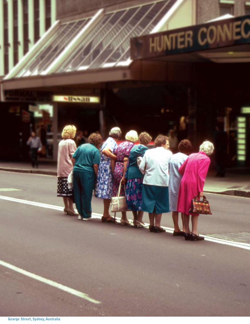
george street, sydney, Australia
The Getting From Here To There Dilemma
consIder the followIng scenArIos:
1. You are standing on the sidewalk at a busy intersection. You would like to cross the street, but traffic is whizzing by non-stop, and the stoplight isn’t changing. Finally, after a long, long wait, the light flashes “walk,” and you venture out. You’re halfway across the vast stretch of pavement, when the light starts to flash “don’t walk.” You frantically scurry to reach the other side before the onslaught of traffic begins again. If you’re lucky, you’ll make it.
2. There’s a new little neighborhood store right near your house, and you’d love to walk there. Although it’s a few short blocks away, a long, continuous dead-end street bars your direct passage. This turns your short stroll into a roundabout hike. What’s worse, there’s no sidewalk along the way. Even if there were a sidewalk, there’s nothing’s en route to make your walk interesting and enjoyable. So, you drive there instead.
3. Shopping at the mall just isn’t the same as what going downtown or strolling along your neighborhood’s shopping street used to be. It lacks the interesting mix of people and the commercial and community activities you remember. On the other hand, the last time you visited “Main Street,” it looked pretty bleak, especially after being widened to accommodate faster traffic. The intimacy and accessibility that made people like to go there are gone, and so is the sense that it’s a special place. Since that speedway cut through, there just doesn’t seem to be any “there” there, as the famous writer Gertrude Stein said.
4. If you’re not chauffeuring your kids around, then you’re picking up your elderly aunt for her doctor’s appointment. It would be nice if your children could walk to school by themselves and not worry about speeding motorists. Your aunt would like to get around by herself, too, but she walks slowly and wouldn’t dare take a chance with those impatient drivers on those wide streets.
I
Introduction
5. The old train station used to be the real heart of town. It’s completely deteriorated now, ugly and barren. There’s not even a bathroom, let alone a place to sit. Waiting for the bus isn’t much better than waiting for the train. No wonder people prefer to drive. If this sounds familiar, it’s not surprising. Similar scenes have taken place all the time throughout the United States and abroad as automobile use has proliferated over the past fifty years. In fact, at this point, as many of us have realized, motor vehicles are exacting a huge toll throughout our society. Here are some of the costs:
close to 40,000 people in the united States are killed each year in traffic accidents, over 7,000 of
them pedestrians and bicyclists.
Vehicle emissions are polluting our air constituting 40-60 percent of urban smog, 80 percent of toxic
carbon monoxide, plus other harmful contaminants. auto emissions are a leading source of the gases
that cause global climate change.
the cost of congestion (e.g., in terms of fuel, time, productivity, business losses) in america’s 29
largest urban areas is estimated at $40 billion a year. [10]
The effect of all this really hits home in the way we live today and what happens to our communities. There was a time in our cities and towns when getting from here to there was a pleasant and often enriching experience. Streets were places where people liked to be, to walk, to shop, to meet, to play, and even just to people-watch. It was easy to get across the street to sidewalks where children were playing; where all kinds of folks were socializing; where an array of stores, services and special community places, like parks, plazas, libraries, train stations, markets, theaters and public squares, were all within easy reach. In a way, the street was like a stage where the community came together and performed a variety show of activities.
Then, as the automobile encroached upon our communities, people and the places were shunted aside. Walking from here to there became risky business, and the friendly quality of streets began to disappear. Impersonal thoroughfares came to dominate our towns, taking over the spaces where people used to meet each other. Businesses closed and left town. The places that made communities special deteriorated and, in some cases, vanished, as people retreated from an ever emptier and alienating streetscape. What once was the essence of community got lost in the hustle of traffic.
How did this come about? Once the automobile hit the road, a one-sided view of the street took over. The overriding priority was moving traffic as speedily as possible. This translated into wider streets, often going only one-way, timing on traffic lights that favored motorists over pedestrians, higher speed limits, broader corners for quicker turns and smaller or no sidewalks. “Capacity” became the watchword, and the goal was making more room for cars.
2
Increased road capacity was supposed to ease traffic congestion. Instead, wider streets kept attracting more and more cars. As a result of this mad rush to serve motor vehicles, U.S. cities now typically devote as much as one-third to one-half of their land to automobiles, whether for roads, parking or other auto-related uses. [10] This trend has served to diminish our public spaces and, as a result, our public life.
The road leading back to reclaiming our communities is long and difficult, but not lost. Another way to use our streets is now emerging in which speed is not the be-all and end-all; taking care of people and place is just as important as pandering to the car. It already has begun to take root in Europe and is starting to blossom in other cities, including some in the United States. For example, traffic calming, which concentrates on slowing down traffic and creating a more balanced urban environment where everyone feels safe using the street, is becoming more prevalent.
By balancing the needs of pedestrians, bicyclists and motorists, traffic calming gives us a chance to recapture public space for rebuilding our communities. This helps foster attractive places that welcome all kinds of activities and serendipitous chance encounters. In a sense, this represents a different way of thinking about what should come first in our communities. When used with other community-building tools, traffic calming can be a potent force to help reshape the places where we live, work and play.
This handbook focuses on a broader view of transportation exemplified by traffic calming, in which people, not cars, become the driving force in shaping our cities and towns. Project for Public Spaces, Inc. (PPS) is a non-profit corporation dedicated to fulfilling that mission by improving the comfort, safety, attractiveness and vitality of streets and other public spaces so that everyone can use and enjoy them. For over 30 years, PPS has been studying how people use public spaces in 26 countries and in over 2,000 communities in the U.S. and abroad and listening to what they say about their needs. The number one issue in nearly all the places we work is traffic and its impact on community life.
We once routinely built such places. Now they are viewed as unique, or even exotic. How-ever, many of their qualities can be incorporated into communities everywhere to create places people are proud to call home. The following chapters discuss how such features can be adapted and applied today to create people-friendly towns and neighborhoods that offer a strong sense of community.
These chapters cover many of the basic elements that can help create good places and en-hance community life, including traffic calming, an innovative approach to the design and management of streets that redistributes street space more equitably for all users and, in doing so, acts as a Placemaking catalyst.
3
There was a time in our cities and towns when getting from here to there was a pleasant and often enriching experience. Then, as the automobile encroached, people and places were shunted aside.
4
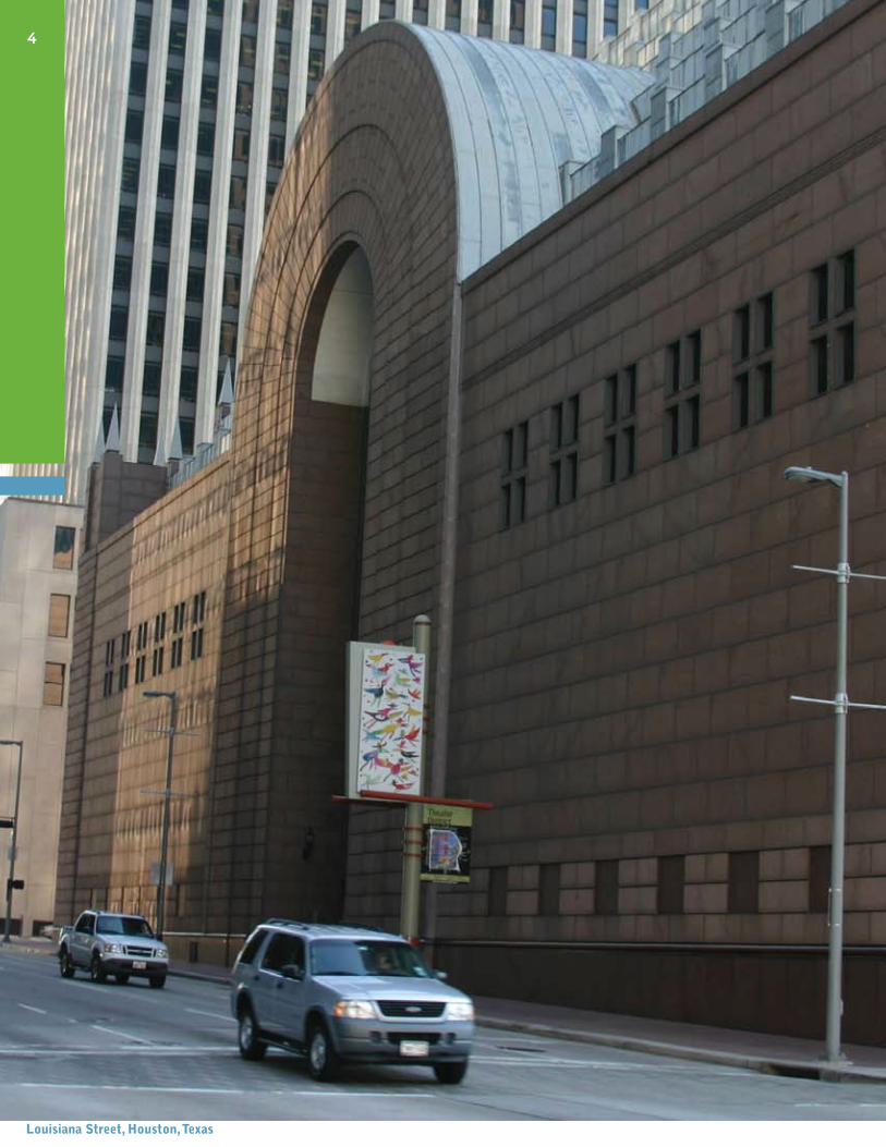
louisiana street, houston, texas
The Case of theDisappearing Place
“Erosion of cities by automobiles...proceeds as a kind of nibbling, small nibbles at first, but eventually hefty bites...A street is widened here, another is straightened there, a wide avenue is converted to one-way flow...more land goes into parking...No one step in this process is, in itself, crucial. But cumulatively the effect is enormous...City character is blurred until every place becomes more like every other place, all adding up to No place.”
Jane Jacobs, The Death and Life of Great American Cities
whAt’s wrong wIth thIs street?
The street pictured on the left is considered to be a major downtown destination of a well-known U.S. city. Yet you hardly see any people! A closer look shows why:
1. Blank walls The building facades say “Stay Away.” At the ground floor there are no doors, shops, services or other features that encourage public activity.
2. A wide street A vast expanse of roadway, with six wide traffic lanes, monopolizes most of the space.
3. fast moving traffic Cars pass by very quickly, which stifles any other activity on the street.
4. narrow sidewalks Although sidewalks, as their name conveys, are for walking, these sidewalk strips are simply too narrow to use.
5. overall Image The general impression here is “People Beware.” Whether or not crime is really an issue, there is a sense of isolation, coupled with the very real threat posed in try-ing to walk across a street with quickly moving traffic, which makes this area feel unsafe.
No wonder this street isn’t filled with people. It is not a place.
II
whAt Is A plAce?
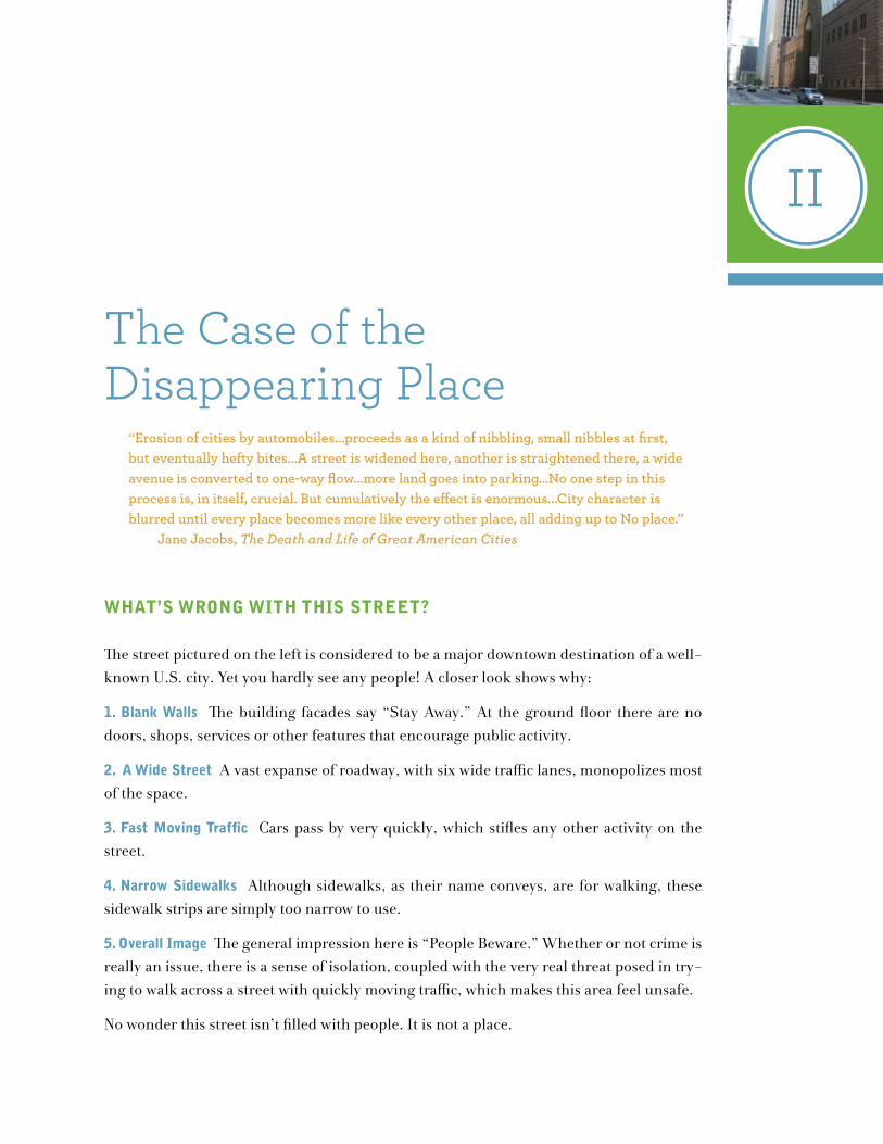
Lately, people have been talking increasingly about “loss of place.” What they’re missing is the kind of place that has been special in their lives and given them a strong sense of com-munity. The street pictured directly above is an example of this type of “place.” A closer look shows that it has:
1. Activity and Interest at the street level People are walking, talking, looking around, sit-ting, standing and going about their business in a setting where they feel like they belong. Instead of blank walls, there are shop windows displaying merchandise, people-sized doors and places to sit.
2. A comfortably scaled street This roadway is narrower than the first one pictured, with fewer lanes for traffic.
3. slow-moving traffic and on-street parking The vehicle traffic here is in balance with pe-destrian activities. Drivers pull in and out of parking spaces at a leisurely pace that doesn’t intimidate people.
4. Ample sidewalks There’s room on the sidewalks for people to walk and for other pedes-trian-friendly activities, like sidewalk cafés.
5. overall Image This street has a personality that identifies it as a special place. It is easy to cross from one side to the other, adding to the overall feeling of safety.
The street above is a place that welcomes people, in contrast to the first street pictured, which is not a place at all. The first street is nothing more than a conduit for motor ve-hicles.
6
oslo, norway
how dId thIs hAppen?
All over the United States today, there are more streets that function merely as conduits for motor vehicles than those that enhance our communities as vital places. Although many began as people-friendly streets that could be shared comfortably by pedestrians and motorists, most have evolved to accommodate an ever-increasing number of cars and trucks. While streets have become wider, sidewalks have become narrower. But no mat-ter how much any street has been widened, it is never wide enough. Every time word gets out that a street has more room for cars, new traffic keeps coming until it’s filled up again.
Widening streets result in diminishing space for people to walk, as well as honking horns and foul emissions that usually drive pedestrians away. This has been compounded by the construction of malls, with vast parking lots that encourage peo-ple to drive. Although the automobile has brought us access and convenience that have enriched and eased our lives, it also has been allowed to domi-nate our environment. Autos helped hasten the disappearance of the distinctive, human-scale places that have long given us a sense of belong-ing in our communities.
In surveys of people across the country, PPS has found that respondents keenly feel the loss of such places. Here are some typical comments in answer to a survery PPS conducted in Meriden, Connecticut:
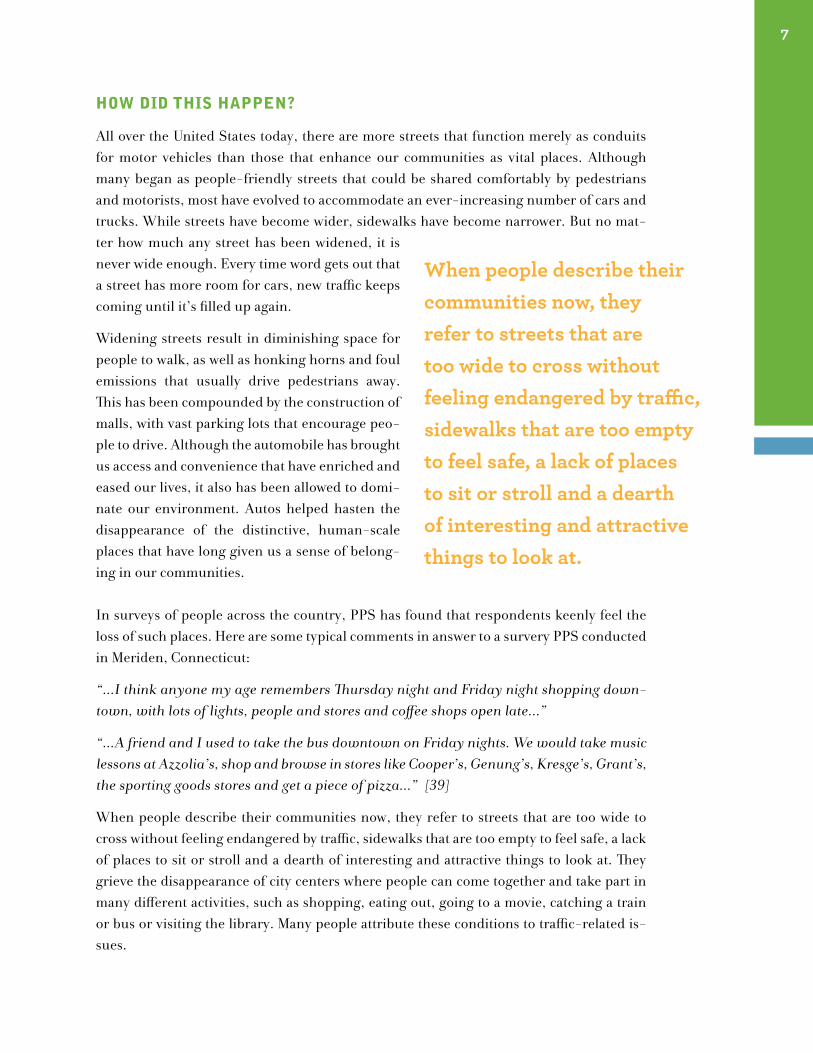
“...I think anyone my age remembers Thursday night and Friday night shopping down-town, with lots of lights, people and stores and coffee shops open late...”
“...A friend and I used to take the bus downtown on Friday nights. We would take music lessons at Azzolia’s, shop and browse in stores like Cooper’s, Genung’s, Kresge’s, Grant’s, the sporting goods stores and get a piece of pizza...” [39]
When people describe their communities now, they refer to streets that are too wide to cross without feeling endangered by traffic, sidewalks that are too empty to feel safe, a lack of places to sit or stroll and a dearth of interesting and attractive things to look at. They grieve the disappearance of city centers where people can come together and take part in many different activities, such as shopping, eating out, going to a movie, catching a train or bus or visiting the library. Many people attribute these conditions to traffic-related is-sues.
7
When people describe their communities now, they refer to streets that are too wide to cross without feeling endangered by traffic, sidewalks that are too empty to feel safe, a lack of places to sit or stroll and a dearth of interesting and attractive things to look at.
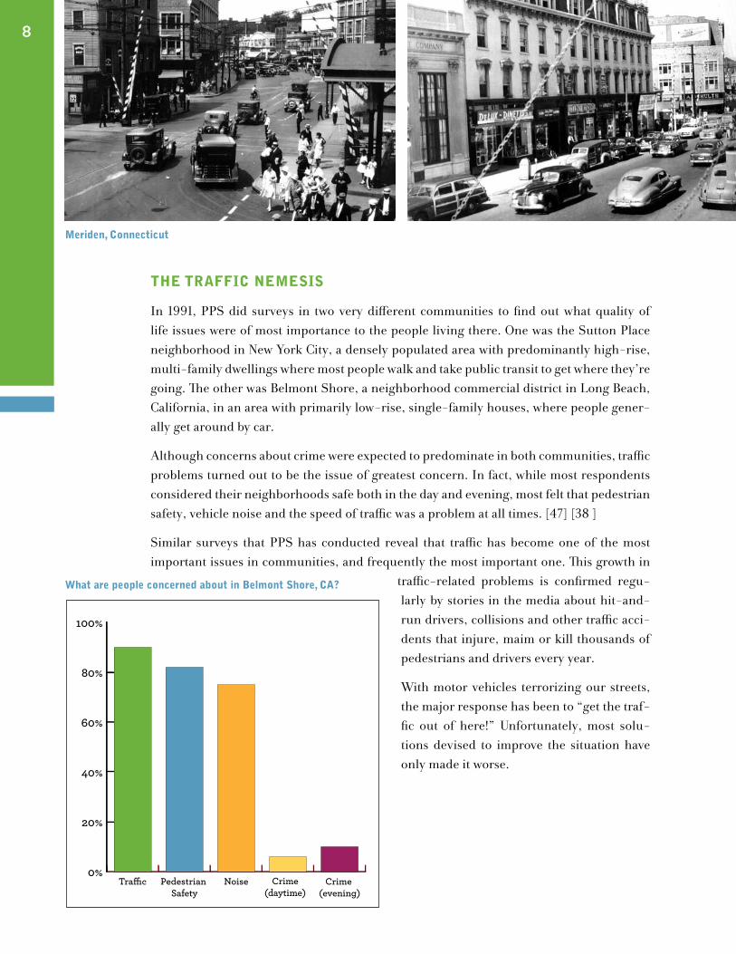
the trAffIc nemesIs
In 1991, PPS did surveys in two very different communities to find out what quality of life issues were of most importance to the people living there. One was the Sutton Place neighborhood in New York City, a densely populated area with predominantly high-rise, multi-family dwellings where most people walk and take public transit to get where they’re going. The other was Belmont Shore, a neighborhood commercial district in Long Beach, California, in an area with primarily low-rise, single-family houses, where people gener-ally get around by car.
Although concerns about crime were expected to predominate in both communities, traffic problems turned out to be the issue of greatest concern. In fact, while most respondents considered their neighborhoods safe both in the day and evening, most felt that pedestrian safety, vehicle noise and the speed of traffic was a problem at all times. [47] [38 ]
Similar surveys that PPS has conducted reveal that traffic has become one of the most important issues in communities, and frequently the most important one. This growth in
traffic-related problems is confirmed regu-larly by stories in the media about hit-and-run drivers, collisions and other traffic acci-dents that injure, maim or kill thousands of pedestrians and drivers every year.
With motor vehicles terrorizing our streets, the major response has been to “get the traf-fic out of here!” Unfortunately, most solu-tions devised to improve the situation have only made it worse.
8
meriden, connecticut
0%
20%
40%
60%
80%
100%
Crime (evening)
NoisePedestrian Safety
Tra�c Crime(daytime)
what are people concerned about in Belmont shore, cA?
remedIes thAt mAke thIngs worse
The typical solution to traffic problems has been to move vehicles through communi-ties, including downtowns, as quickly as possible. To facilitate this movement, so-called “transportation improvements” have been made, vastly changing streets’ appearances and the way they function. One technique, widening streets and traffic lanes, already has been discussed. Other problematic “cures” include:
one-way streets Two-way streets are converted to one-way, or broad new one-way streets built, to allow for greater traffic flow. But people in com-munities now have to contend with dangerous speedways that disconnect people on one side of the street from the other. People in communities as varied as Austin, Texas; Lexington, Kentucky; New Haven, Connecticut; and St. Charles, Illinois all report the same experience with wide one-way streets: they find that they not only decrease pe-destrian safety, but also interfere with the overall accessibility and cohesiveness of the surrounding neighborhood, leading to less street life and re-duced business activity.
elimination of on-street parking This adds more traffic lanes to the street and encourages more speeding traffic. It also hurts neighborhood busi-nesses by preventing motorists from easily stop-ping off to shop or do errands along the street. The next step usually is to build parking garages, often taking people off the street completely. Ironically, the police are usually better at enforcing “no parking” rules than at preventing cars from speeding through neighborhoods.
traffic signal timing Generally, traffic lights are synchronized, so that drivers can keep moving steadily without having to stop at red lights. This, along with a longer green time for vehicles (meaning less “walk” time on the signal) makes it difficult for pedestrians to get across a street, particularly older people, children and those with physical disabilities.
“I would like to see more pedestrian walk lights...I have been almost clipped several times. I am 80 years old and use a cane and cannot walk rapidly.” (From a PPS survey of Springfield, Massachusetts residents in 1987) [45]
9
peachtree street, Atlanta, georgia
Broad corner turning curves One can see how much easier it is for a car or truck to turn around a curve with a large radius, say 25 to 50 feet, than around a radius of 15 feet or less. But anyone who has ever started to cross a street at an intersection and suddenly been con-fronted by a car whizzing around the corner knows what such a broad corner radius can mean: higher speeds for vehicles; longer crossings and less warning time to see oncoming cars (in other words, danger) for pedestrians.
speed limits and street design The design of a street affects how fast motorists drive much more than the posted speed limit. The higher the speed limit, of course, the faster motorists will drive their vehicles. However, even when speed limits on a street are low, driving fast
still frequently happens when streets are designed in a way that makes speeding easy: very wide, very straight and very flat. In Tallahassee, Florida, a police officer complained that he was constantly ticketing Monroe Street’s drivers for traveling above the speed limit. “If only people would design these streets so that drivers would go the speed limit,” he said, “I could be spend-ing my time doing other things. Right now, all they do is change the limit on a sign!”
One thing is clear—the greater the speed, the greater threat to pedestrians. Research has shown that when automobiles hit pedestrians at 20 mph, only 5 percent of those hit are killed, most injuries are slight and 30 percent suffer no injury; at 30 mph, 45 percent of pe-destrians are killed, and many are injured seriously; at 40 mph, 85 percent are killed. [33 ]
10
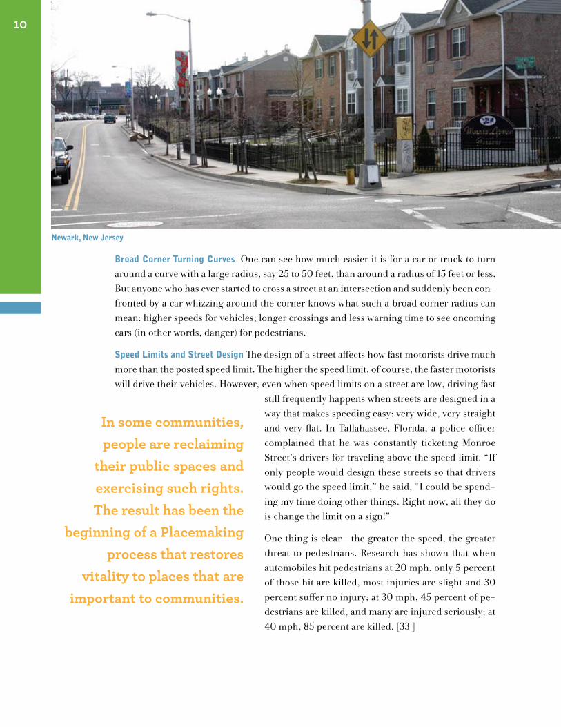
In some communities, people are reclaiming
their public spaces and exercising such rights. The result has been the
beginning of a Placemaking process that restores
vitality to places that are important to communities.
newark, new Jersey
who owns the roAd?
The above so-called “solutions” focus nar-rowly on traffic and how it can be expedited instead of addressing how traffic can fit into a vision for building livable communities. Because of this, motor vehicles have become true “road hogs” or, more aptly, “space hogs.” They greedily gobble up more and more pub-lic space, leaving less and less for people to enjoy.
Up to now, despite our grumbling, most pe-destrians have stepped aside and accepted this inequitable state of affairs and, in doing so, have given up a large part of the public realm to cars. Before we give up any more of this valuable public space, it might be helpful to remember that it rightly belongs to all of the people in the community. A public space “Bill of Rights” could be developed (See example above)
sIgns of hope
Even as far back as the 1950s, a coalition of community, civic and business groups was successful in defeating the Lower Manhattan Expressway in New York City. Had this pro-posed highway been built, it would have ripped the city apart and caused the destruction of numerous buildings, as well as the displacement of their occupants. Today that area is the world renowned SoHo neighborhood. Plans to upgrade access to the proposed ex-pressway by widening and straightening roads through Greenwich Village’s Washington Square Park also were successfully fought off. Then, having achieved this victory, citizens decided that no roads at all belonged in the park! After a long, hard fight, their campaign paid off. Washington Square Park was closed to traffic forever in 1959. Dire predictions of congestion popping up in other areas never materialized. [11]
In some cities, people are reclaiming their public spaces and exercising their rights to public space. One way of doing this is to create a public space “Bill of Rights,” a list of activies they would like to be able to do in their communities. (See example above). This is the beginning of a Placemaking process that restores vitality to places that are important to communities.
These are just a few of the examples coast-to-coast, where people have taken a stand to preserve the places they consider important and restored a healthy balance between ve-hicles and people. Of course, there are also some communities that always have had a comfortable balance between traffic and people, and they keep it to this day. Some are examined in the next chapter. They are living, lasting proof that there is a Placemaking alternative to the current traffic-take-all approach.
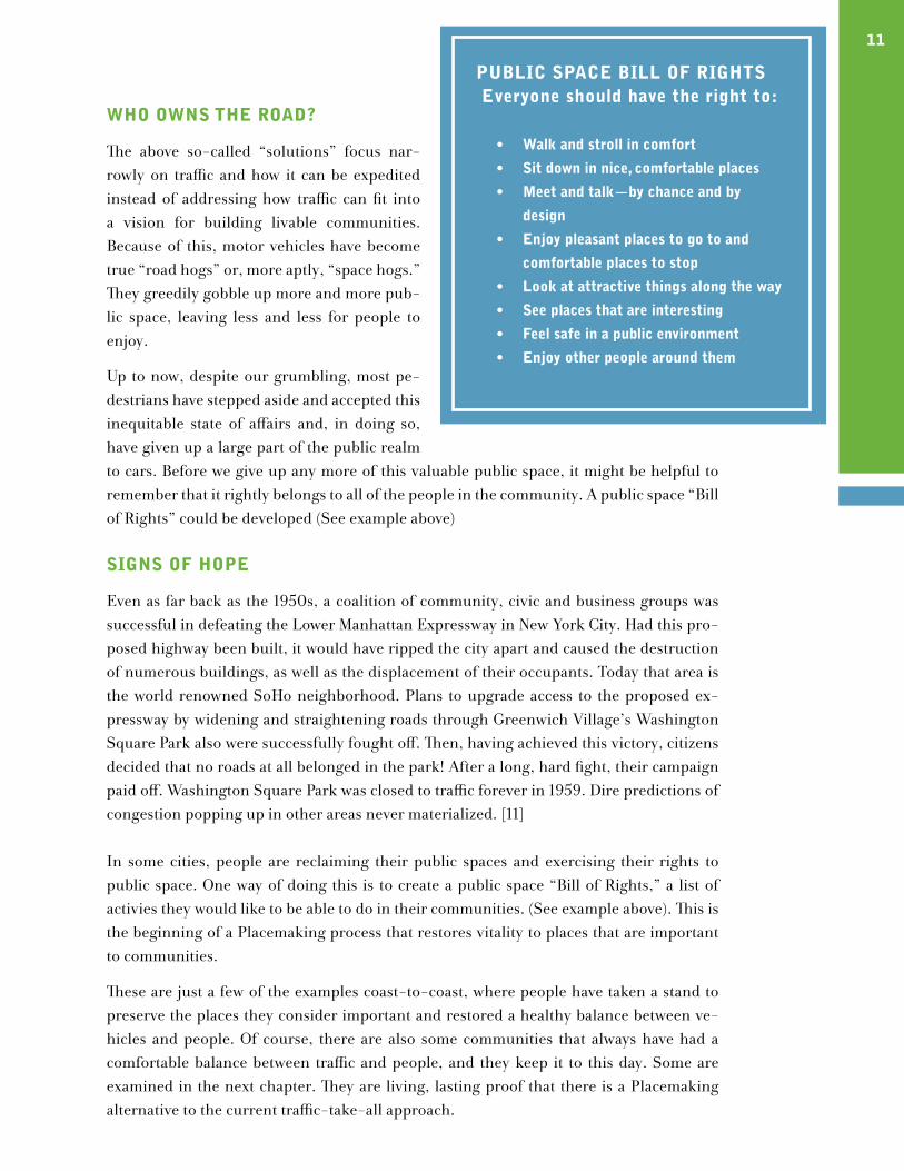
11puBlIc spAce BIll of rIghts everyone should have the right to:
walk and stroll in comfort•
sit down in nice, comfortable places •
meet and talk—by chance and by •
design
enjoy pleasant places to go to and •
comfortable places to stop
look at attractive things along the way•
see places that are interesting•
feel safe in a public environment•
enjoy other people around them•
12
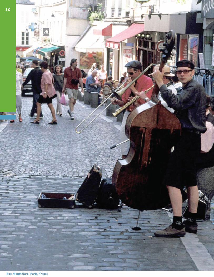
rue mouffetard, paris, france
Valuable Lessons From the Past
“The thing I like best about the squares,” Miss Harty said, “is that cars can’t cut through the middle; they must go around them. So traffic is obliged to flow at a very leisurely pace. The squares are our little oases of tranquility.”
Mary Harty describing Savannah, Georgia in John Berendt’s Midnight in the Garden of Good and Evil
“Standing shoulder to shoulder, the row houses of Georgetown create a pleasant streetwall that affords a sense of secure enclosure...Mature trees in orderly rows provide additional enclosure...Cars parked along each side of the street provide cushioning for pedestrians from the moving vehicles.”
James Howard Kunstler, The Geography of Nowhere
lIVIng, lAstIng lIVABle plAces
At one time or another, almost all of us have come across certain places we consider to be especially appealing and livable. Such places might be embodied in a single street or even a street corner, in a series of streets, a district or an entire community. To describe these places, we often use words like “charming” or “comfortable” or “convenient” with-out pinpointing their actual features. All over the United States, there are places like these that have managed to retain this kind of comfort and livability through the years, in spite of changes going on around them. Learning about their qualities can provide clues about how to create streets that are special places for people, reflecting a strong sense of com-munity. To help identify such features, this chapter presents a sampling of some of these still-functioning, friendly-to-people places. These places don’t necessarily have all of the same features, although many share a number of them. One of the most common character-istics is that they haven’t been overwhelmed by wide, fast roads. Their streets are narrow and crossable, and they often have serendipitous restraints on traffic, like the sequence of squares in Savannah, Georgia. Besides tempering traffic, Savannah’s squares, with their
III
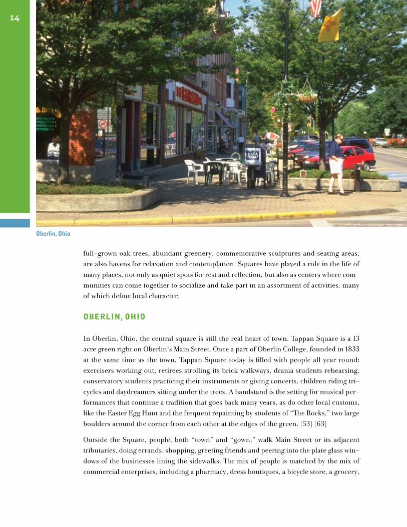
full-grown oak trees, abundant greenery, commemorative sculptures and seating areas, are also havens for relaxation and contemplation. Squares have played a role in the life of many places, not only as quiet spots for rest and reflection, but also as centers where com-munities can come together to socialize and take part in an assortment of activities, many of which define local character. oBerlIn, ohIo
In Oberlin, Ohio, the central square is still the real heart of town. Tappan Square is a 13 acre green right on Oberlin’s Main Street. Once a part of Oberlin College, founded in 1833 at the same time as the town, Tappan Square today is filled with people all year round: exercisers working out, retirees strolling its brick walkways, drama students rehearsing, conservatory students practicing their instruments or giving concerts, children riding tri-cycles and daydreamers sitting under the trees. A bandstand is the setting for musical per-formances that continue a tradition that goes back many years, as do other local customs, like the Easter Egg Hunt and the frequent repainting by students of “The Rocks,” two large boulders around the corner from each other at the edges of the green. [53] [63]
Outside the Square, people, both “town” and “gown,” walk Main Street or its adjacent tributaries, doing errands, shopping, greeting friends and peering into the plate glass win-dows of the businesses lining the sidewalks. The mix of people is matched by the mix of commercial enterprises, including a pharmacy, dress boutiques, a bicycle store, a grocery,
14
oberlin, ohio
a book shop, a beauty salon, some night spots and a movie theater. There also is a wealth of eateries, ranging from a four-star restaurant to a pizzeria to a late-night bistro to the din-ers, where students hang out, play chess, and eat, and drink milkshakes. One of the most popular vendors is the almost century-old Gibson’s, a combination bakery, ice cream par-lor and candy emporium that makes all its own delicacies. Gibson’s also sells newspapers and, when the good weather arrives, operates a sidewalk café. Adding to the delightful mix are institutions like the local post office, Oberlin’s Allen Art Museum and Mudd Library. [53] [65]
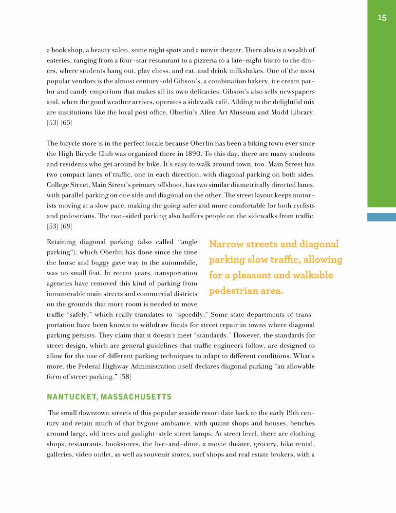
The bicycle store is in the perfect locale because Oberlin has been a biking town ever since the High Bicycle Club was organized there in 1890. To this day, there are many students and residents who get around by bike. It’s easy to walk around town, too. Main Street has two compact lanes of traffic, one in each direction, with diagonal parking on both sides. College Street, Main Street’s primary offshoot, has two similar diametrically directed lanes, with parallel parking on one side and diagonal on the other. The street layout keeps motor-ists moving at a slow pace, making the going safer and more comfortable for both cyclists and pedestrians. The two-sided parking also buffers people on the sidewalks from traffic. [53] [69]
Retaining diagonal parking (also called “angle parking”), which Oberlin has done since the time the horse and buggy gave way to the automobile, was no small feat. In recent years, transportation agencies have removed this kind of parking from innumerable main streets and commercial districts on the grounds that more room is needed to move traffic “safely,” which really translates to “speedily.” Some state departments of trans-portation have been known to withdraw funds for street repair in towns where diagonal parking persists. They claim that it doesn’t meet “standards.” However, the standards for street design, which are general guidelines that traffic engineers follow, are designed to allow for the use of different parking techniques to adapt to different conditions. What’s more, the Federal Highway Administration itself declares diagonal parking “an allowable form of street parking.” [58]
nAntucket, mAssAchusetts
The small downtown streets of this popular seaside resort date back to the early 19th cen-tury and retain much of that bygone ambiance, with quaint shops and houses, benches around large, old trees and gaslight-style street lamps. At street level, there are clothing shops, restaurants, bookstores, the five-and-dime, a movie theater, grocery, bike rental, galleries, video outlet, as well as souvenir stores, surf shops and real estate brokers, with a
15
Narrow streets and diagonal parking slow traffic, allowing for a pleasant and walkable pedestrian area.
16
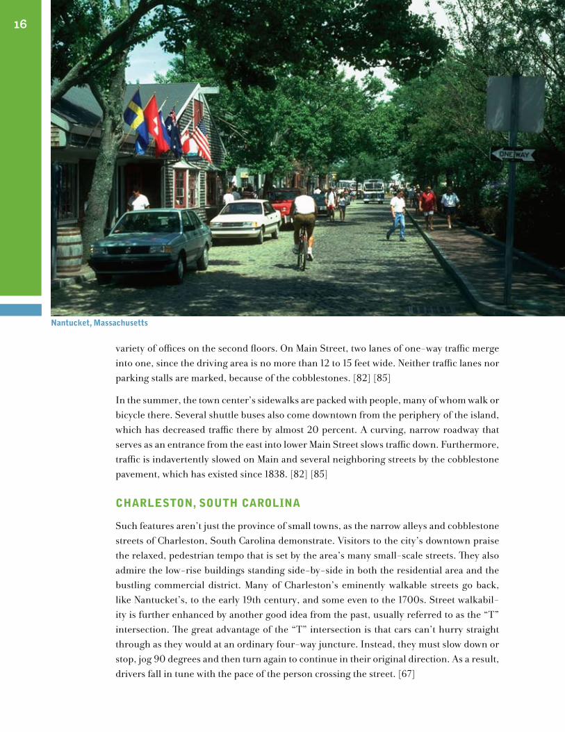
variety of offices on the second floors. On Main Street, two lanes of one-way traffic merge into one, since the driving area is no more than 12 to 15 feet wide. Neither traffic lanes nor parking stalls are marked, because of the cobblestones. [82] [85]
In the summer, the town center’s sidewalks are packed with people, many of whom walk or bicycle there. Several shuttle buses also come downtown from the periphery of the island, which has decreased traffic there by almost 20 percent. A curving, narrow roadway that serves as an entrance from the east into lower Main Street slows traffic down. Furthermore, traffic is indavertently slowed on Main and several neighboring streets by the cobblestone pavement, which has existed since 1838. [82] [85]
chArleston, south cArolInA
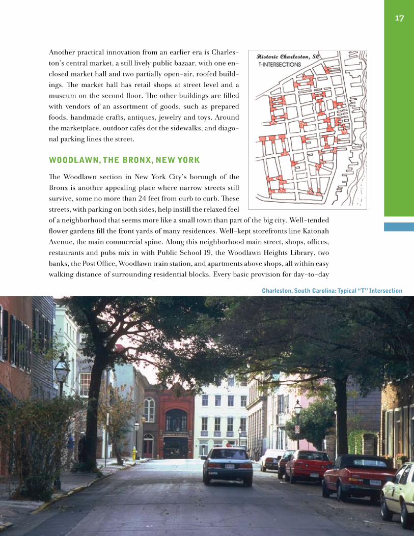
Such features aren’t just the province of small towns, as the narrow alleys and cobblestone streets of Charleston, South Carolina demonstrate. Visitors to the city’s downtown praise the relaxed, pedestrian tempo that is set by the area’s many small-scale streets. They also admire the low-rise buildings standing side-by-side in both the residential area and the bustling commercial district. Many of Charleston’s eminently walkable streets go back, like Nantucket’s, to the early 19th century, and some even to the 1700s. Street walkabil-ity is further enhanced by another good idea from the past, usually referred to as the “T” intersection. The great advantage of the “T” intersection is that cars can’t hurry straight through as they would at an ordinary four-way juncture. Instead, they must slow down or stop, jog 90 degrees and then turn again to continue in their original direction. As a result, drivers fall in tune with the pace of the person crossing the street. [67]
nantucket, massachusetts
17
Another practical innovation from an earlier era is Charles-ton’s central market, a still lively public bazaar, with one en-closed market hall and two partially open-air, roofed build-ings. The market hall has retail shops at street level and a museum on the second floor. The other buildings are filled with vendors of an assortment of goods, such as prepared foods, handmade crafts, antiques, jewelry and toys. Around the marketplace, outdoor cafés dot the sidewalks, and diago-nal parking lines the street.
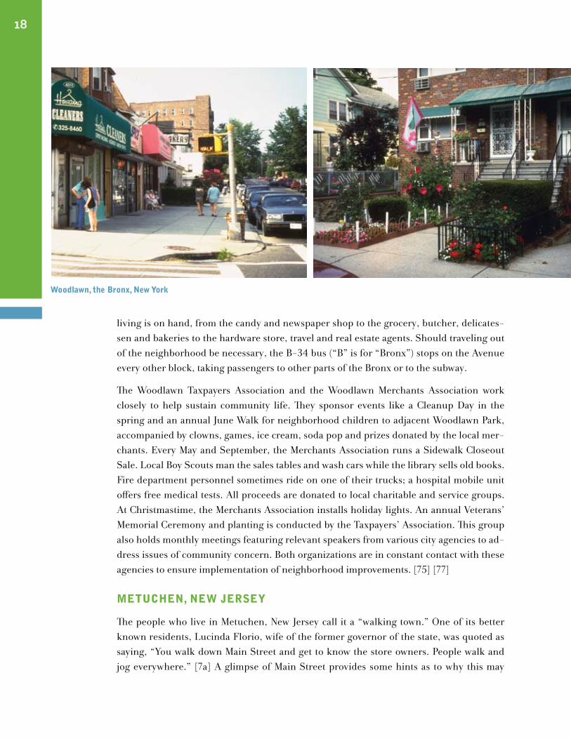
woodlAwn, the BronX, new York
The Woodlawn section in New York City’s borough of the Bronx is another appealing place where narrow streets still survive, some no more than 24 feet from curb to curb. These streets, with parking on both sides, help instill the relaxed feel of a neighborhood that seems more like a small town than part of the big city. Well-tended flower gardens fill the front yards of many residences. Well-kept storefronts line Katonah Avenue, the main commercial spine. Along this neighborhood main street, shops, offices, restaurants and pubs mix in with Public School 19, the Woodlawn Heights Library, two banks, the Post Office, Woodlawn train station, and apartments above shops, all within easy walking distance of surrounding residential blocks. Every basic provision for day-to-day
charleston, south carolina: typical “t” Intersection
18
living is on hand, from the candy and newspaper shop to the grocery, butcher, delicates-sen and bakeries to the hardware store, travel and real estate agents. Should traveling out of the neighborhood be necessary, the B-34 bus (“B” is for “Bronx”) stops on the Avenue every other block, taking passengers to other parts of the Bronx or to the subway.
The Woodlawn Taxpayers Association and the Woodlawn Merchants Association work closely to help sustain community life. They sponsor events like a Cleanup Day in the spring and an annual June Walk for neighborhood children to adjacent Woodlawn Park, accompanied by clowns, games, ice cream, soda pop and prizes donated by the local mer-chants. Every May and September, the Merchants Association runs a Sidewalk Closeout Sale. Local Boy Scouts man the sales tables and wash cars while the library sells old books. Fire department personnel sometimes ride on one of their trucks; a hospital mobile unit offers free medical tests. All proceeds are donated to local charitable and service groups. At Christmastime, the Merchants Association installs holiday lights. An annual Veterans’ Memorial Ceremony and planting is conducted by the Taxpayers’ Association. This group also holds monthly meetings featuring relevant speakers from various city agencies to ad-dress issues of community concern. Both organizations are in constant contact with these agencies to ensure implementation of neighborhood improvements. [75] [77]
metuchen, new JerseY
The people who live in Metuchen, New Jersey call it a “walking town.” One of its better known residents, Lucinda Florio, wife of the former governor of the state, was quoted as saying, “You walk down Main Street and get to know the store owners. People walk and jog everywhere.” [7a] A glimpse of Main Street provides some hints as to why this may
woodlawn, the Bronx, new York
19
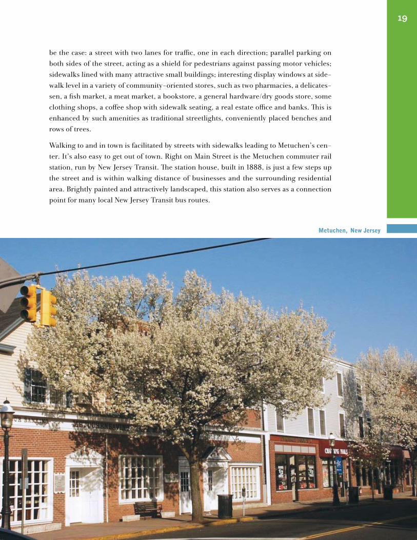
be the case: a street with two lanes for traffic, one in each direction; parallel parking on both sides of the street, acting as a shield for pedestrians against passing motor vehicles; sidewalks lined with many attractive small buildings; interesting display windows at side-walk level in a variety of community-oriented stores, such as two pharmacies, a delicates-sen, a fish market, a meat market, a bookstore, a general hardware/dry goods store, some clothing shops, a coffee shop with sidewalk seating, a real estate office and banks. This is enhanced by such amenities as traditional streetlights, conveniently placed benches and rows of trees.
Walking to and in town is facilitated by streets with sidewalks leading to Metuchen’s cen-ter. It’s also easy to get out of town. Right on Main Street is the Metuchen commuter rail station, run by New Jersey Transit. The station house, built in 1888, is just a few steps up the street and is within walking distance of businesses and the surrounding residential area. Brightly painted and attractively landscaped, this station also serves as a connection point for many local New Jersey Transit bus routes.
metuchen, new Jersey
20
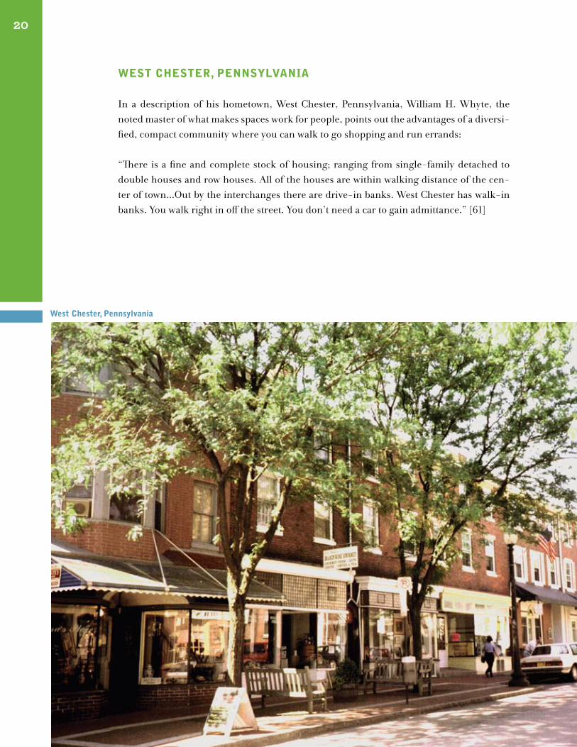
west chester, pennsYlVAnIA
In a description of his hometown, West Chester, Pennsylvania, William H. Whyte, the noted master of what makes spaces work for people, points out the advantages of a diversi-fied, compact community where you can walk to go shopping and run errands: “There is a fine and complete stock of housing; ranging from single-family detached to double houses and row houses. All of the houses are within walking distance of the cen-ter of town...Out by the interchanges there are drive-in banks. West Chester has walk-in banks. You walk right in off the street. You don’t need a car to gain admittance.” [61]
west chester, pennsylvania
whAt we cAn leArn from these greAt plAces
These are some of the characteristics that can be found in older towns celebrated for their livability: small streets more for walking than for driving
town squares
strong commercial centers with a mix of activities
A down-to-earth scale
friendly to bicycles
traditional local celebrations
public markets
diagonal parking
sidewalk cafés
A transit station or stop that’s easy to walk to, right in the center of town
trees and flowers
An involved community
We once routinely built such places. Now they are viewed as unique, or even exotic. How-ever, many of their qualities can be incorporated into communities everywhere to create places people are proud to call home. The next two chapters discuss how such features can be adapted and applied today to create people-frienly towns and neighborhoods that offer a strong sense of community.
The first of these chapters covers many of the basic elements that can help create good places and enhance community life. The chapter after that discusses traffic calming, and innovative approach to the design and management of streets tha redistributes street space more equitably for all users and, in doing so, acts as a Placemaking catalyst.
21
22
campus martius, detroit, michigan
A Toolkit
“All organisms have inner form—cells, tissues and organs—which interact and are organized in a way that maximizes the efficiency of each part and allows each part to make its vital contribution to the life of the organism...Such things as neighborhood stores, even small things such as chairs, art, fountains and safe walkways, play an essential part in the inner form and balance [of cities].”
David Engwicht, Reclaiming Our Cities and Towns: Better Living With Less Traffic
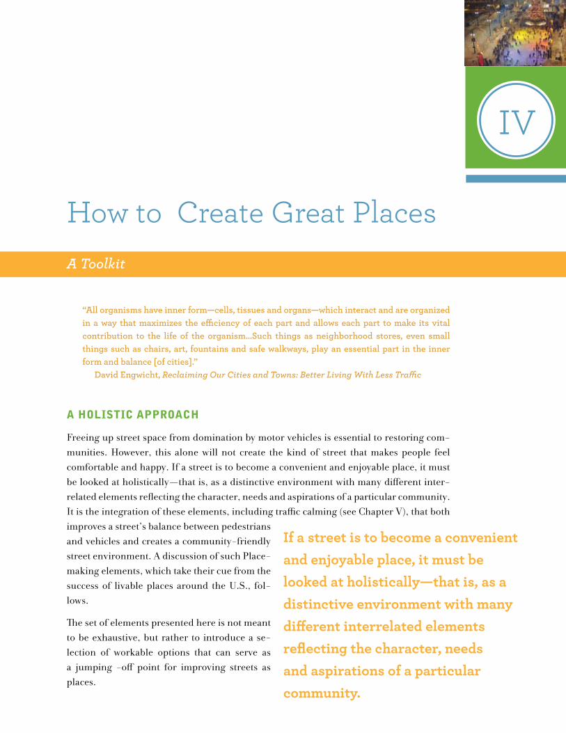
A holIstIc ApproAch
Freeing up street space from domination by motor vehicles is essential to restoring com-munities. However, this alone will not create the kind of street that makes people feel comfortable and happy. If a street is to become a convenient and enjoyable place, it must be looked at holistically—that is, as a distinctive environment with many different inter-related elements reflecting the character, needs and aspirations of a particular community. It is the integration of these elements, including traffic calming (see Chapter V), that both improves a street’s balance between pedestrians and vehicles and creates a community-friendly street environment. A discussion of such Place-making elements, which take their cue from the success of livable places around the U.S., fol-lows.
The set of elements presented here is not meant to be exhaustive, but rather to introduce a se-lection of workable options that can serve as a jumping -off point for improving streets as places.
IV
If a street is to become a convenient and enjoyable place, it must be looked at holistically—that is, as a distinctive environment with many different interrelated elements reflecting the character, needs and aspirations of a particular community.
How to Create Great Places
spAces
Sidewalks
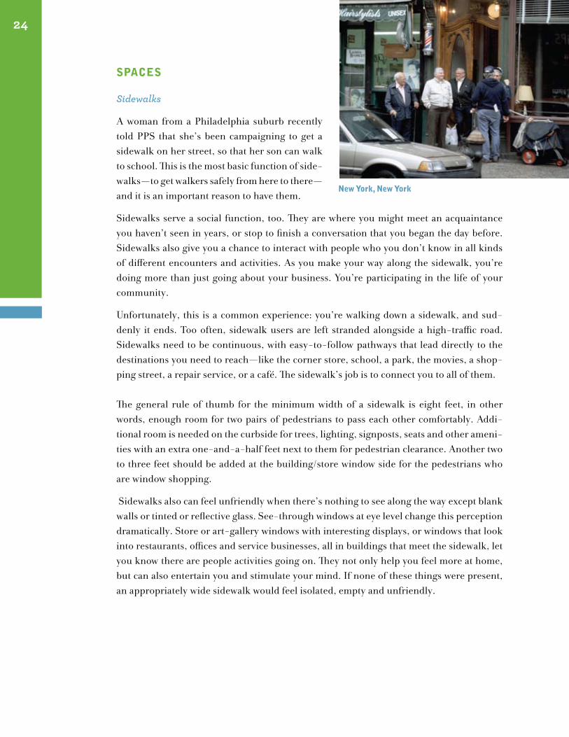
A woman from a Philadelphia suburb recently told PPS that she’s been campaigning to get a sidewalk on her street, so that her son can walk to school. This is the most basic function of side-walks—to get walkers safely from here to there—and it is an important reason to have them.
Sidewalks serve a social function, too. They are where you might meet an acquaintance you haven’t seen in years, or stop to finish a conversation that you began the day before. Sidewalks also give you a chance to interact with people who you don’t know in all kinds of different encounters and activities. As you make your way along the sidewalk, you’re doing more than just going about your business. You’re participating in the life of your community.
Unfortunately, this is a common experience: you’re walking down a sidewalk, and sud-denly it ends. Too often, sidewalk users are left stranded alongside a high-traffic road. Sidewalks need to be continuous, with easy-to-follow pathways that lead directly to the destinations you need to reach—like the corner store, school, a park, the movies, a shop-ping street, a repair service, or a café. The sidewalk’s job is to connect you to all of them. The general rule of thumb for the minimum width of a sidewalk is eight feet, in other words, enough room for two pairs of pedestrians to pass each other comfortably. Addi-tional room is needed on the curbside for trees, lighting, signposts, seats and other ameni-ties with an extra one-and-a-half feet next to them for pedestrian clearance. Another two to three feet should be added at the building/store window side for the pedestrians who are window shopping.
Sidewalks also can feel unfriendly when there’s nothing to see along the way except blank walls or tinted or reflective glass. See-through windows at eye level change this perception dramatically. Store or art-gallery windows with interesting displays, or windows that look into restaurants, offices and service businesses, all in buildings that meet the sidewalk, let you know there are people activities going on. They not only help you feel more at home, but can also entertain you and stimulate your mind. If none of these things were present, an appropriately wide sidewalk would feel isolated, empty and unfriendly.
24
new York, new York
new York, new York
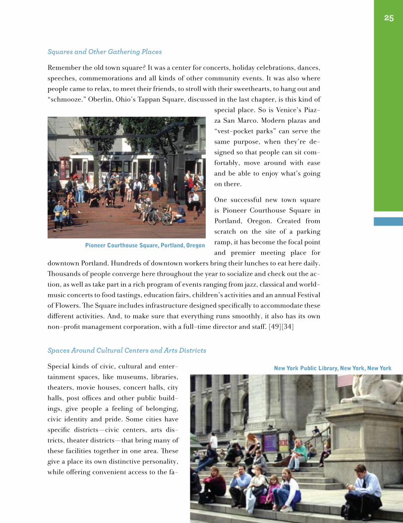
Squares and Other Gathering Places
Remember the old town square? It was a center for concerts, holiday celebrations, dances, speeches, commemorations and all kinds of other community events. It was also where people came to relax, to meet their friends, to stroll with their sweethearts, to hang out and “schmooze.” Oberlin, Ohio’s Tappan Square, discussed in the last chapter, is this kind of
special place. So is Venice’s Piaz-za San Marco. Modern plazas and “vest-pocket parks” can serve the same purpose, when they’re de-signed so that people can sit com-fortably, move around with ease and be able to enjoy what’s going on there.
One successful new town square is Pioneer Courthouse Square in Portland, Oregon. Created from scratch on the site of a parking ramp, it has become the focal point and premier meeting place for
downtown Portland. Hundreds of downtown workers bring their lunches to eat here daily. Thousands of people converge here throughout the year to socialize and check out the ac-tion, as well as take part in a rich program of events ranging from jazz, classical and world-music concerts to food tastings, education fairs, children’s activities and an annual Festival of Flowers. The Square includes infrastructure designed specifically to accommodate these different activities. And, to make sure that everything runs smoothly, it also has its own non-profit management corporation, with a full-time director and staff. [49][34]
Spaces Around Cultural Centers and Arts Districts
Special kinds of civic, cultural and enter-tainment spaces, like museums, libraries, theaters, movie houses, concert halls, city halls, post offices and other public build-ings, give people a feeling of belonging, civic identity and pride. Some cities have specific districts—civic centers, arts dis-tricts, theater districts—that bring many of these facilities together in one area. These give a place its own distinctive personality, while offering convenient access to the fa-
25
new York public library, new York, new York
pioneer courthouse square, portland, oregon
cilities all in one place. They should be designed to be comfortable for pedestrians, not just accessible to vehicles.
Eateries and “Drinkeries”
Most people like to stop for a bite to eat or a refreshing drink. That’s why dispensers of food and beverages always enhance a place, from the humble hot-dog vendor to the coffee shop, sidewalk café, pub and restaurant. Food can be a universal, easy, immediate way to activate public space.
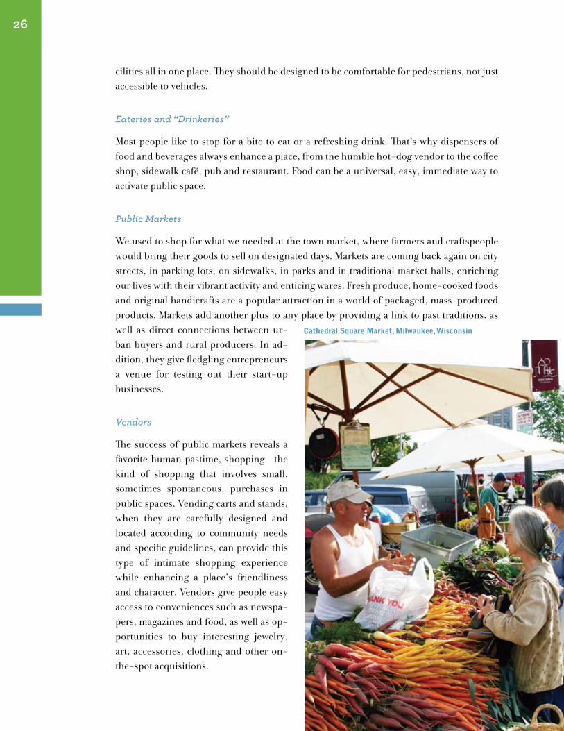
Public Markets
We used to shop for what we needed at the town market, where farmers and craftspeople would bring their goods to sell on designated days. Markets are coming back again on city streets, in parking lots, on sidewalks, in parks and in traditional market halls, enriching our lives with their vibrant activity and enticing wares. Fresh produce, home-cooked foods and original handicrafts are a popular attraction in a world of packaged, mass-produced products. Markets add another plus to any place by providing a link to past traditions, as well as direct connections between ur-ban buyers and rural producers. In ad-dition, they give fledgling entrepreneurs a venue for testing out their start-up businesses.
Vendors
The success of public markets reveals a favorite human pastime, shopping—the kind of shopping that involves small, sometimes spontaneous, purchases in public spaces. Vending carts and stands, when they are carefully designed and located according to community needs and specific guidelines, can provide this type of intimate shopping experience while enhancing a place’s friendliness and character. Vendors give people easy access to conveniences such as newspa-pers, magazines and food, as well as op-portunities to buy interesting jewelry, art, accessories, clothing and other on-the-spot acquisitions.
26
cathedral square market, milwaukee, wisconsin
AmenItIes
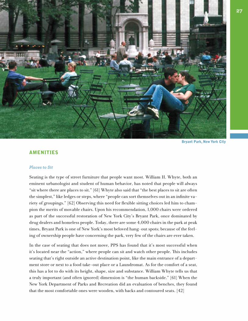
Places to Sit
Seating is the type of street furniture that people want most. William H. Whyte, both an eminent urbanologist and student of human behavior, has noted that people will always “sit where there are places to sit.” [61] Whyte also said that “the best places to sit are often the simplest,” like ledges or steps, where “people can sort themselves out in an infinite va-riety of groupings.” [62] Observing this need for flexible sitting choices led him to cham-pion the merits of movable chairs. Upon his recommendation, 1,000 chairs were ordered as part of the successful restoration of New York City’s Bryant Park, once dominated by drug dealers and homeless people. Today, there are some 4,000 chairs in the park at peak times, Bryant Park is one of New York’s most beloved hang-out spots; because of the feel-ing of ownership people have concerning the park, very few of the chairs are ever taken.
In the case of seating that does not move, PPS has found that it’s most successful when it’s located near the “action,” where people can sit and watch other people. This includes seating that’s right outside an active destination point, like the main entrance of a depart-ment store or next to a food take-out place or a Laundromat. As for the comfort of a seat, this has a lot to do with its height, shape, size and substance. William Whyte tells us that a truly important (and often ignored) dimension is “the human backside.” [61] When the New York Department of Parks and Recreation did an evaluation of benches, they found that the most comfortable ones were wooden, with backs and contoured seats. [42]
27
Bryant park, new York city
“Flower Power”
One of the cardinal rules for community revitaliza-tion is “Start Small.” Small, doable improvements get a project going, and flowers are a good way to make that start. Flowers, with their beautiful colors brighten up any area, whether in tubs, pots, gardens or hanging planters. Other kinds of greenery, like shrubs and bushes, grass and, of course, trees, can soften a harsh environment, lend a natural lushness, refresh the air and help screen out noise. What’s more, they can create pathways and define one area from another. An avenue of trees can make a street look narrower than it really is, discouraging drivers from speeding.
Public Art
Art enhances our public living rooms as it does our private ones, but in public it does much more. When it fits well into its surround-ings, public art expresses the spirit of a place. It brings people together, provides a setting for diverse hap-penings and elicits conversation and interaction. It can highlight the function of one particular part of a place. Sometimes public art even breaks down barriers in a way that leads to all kinds of creative expres-sions and encounters.
Signs
Signs can show the way, show the rules, show what’s happening, and what’s happened. People feel most comfortable in a place when they have their bearings. In order to see the name of the street where they’ve just arrived or directions to where they’re heading, both pedestrians and drivers need signs that are positioned (and lettered large enough) for their easy reading. If rules are needed, it’s important that they be stated clearly and courteously. Signs with colorful illustrations or even some humor can further help people accept and
28
central park, new York, new York
south street seaport, nY
woodstock, Vermont
understand reasonable rules, while also contributing some interesting ambiance to a place.
Some signs give information about a spe-cific place: about events that are going on, public transportation schedules or details about history and unique local features. Again, clarity, visibility and attractive design will provide people with the ori-entation they need while adding to their enjoyment.
But there can be too much of a good thing. Too many signs create an overload of confusion even for those familiar with a place.
Among the other furnishings that can make our outdoor living room more pleasant and comfortable to use are: lighting, Bus shelters, trash receptacles, public clocks, Bicycle
racks and fountains.
As lovely as all these amenities appear to be, they cannot do their job of improving the urban environment unless some “decorating hints” are followed. And the first hint is not to view them as just decorations! Amenities that are placed in regimented rows with fixed spacing and no regard for how they might be comfortably used often become no more than superficial frills, as do those that are scattered haphazardly. There also can be too many amenities crowded into one place. In order for an amenity to work, it must respond to the needs of a location, to the activities that take place there and to people’s patterns of use. Anything that is far away or difficult to reach, such as a water fountain blocks away from the center of activity, will provide neither comfort nor a convenient service. The placement of amenities in relation to one another also is a consideration, affecting the way a space is perceived and used. For example, a bench, food-vending cart and waste receptacle located next to each other give people an opportunity to sit down, have a snack and then dispose of the food container, all in the same place.
Protection from the weather and opportunities for sun, shade and light are also important variables that should be taken into account in the selection and siting of amenities.
29
celeBrAtIons, showsAnd gAtherIngs
The July 4th fireworks celebration, harvest festival or Labor Day parade are examples of traditional events that used to bring com-munities together, and in many places they still do. Nowadays, an abundant array of lo-cal events that fit the needs and interests of today’s communities are being programmed by cities and management organizations. Some of these have developed into large-scale celebrations that attract thousands of
people, like Portland, Oregon’s Art Focus that brings sculpture, performers and painting exhibits to downtown public spaces, accompanied by local restaurants showcasing their wares at food booths lining temporarily closed streets. [27]
Live performances, like jazz, rock and folk concerts, classical-music series, dramatic pre-sentations, magic shows, even lectures and demonstrations, also bring people back to public spaces to share the collective enjoyment and connection that has always enriched communities. These new local traditions, some initiated by neighborhoods, are helping to build community bonds and a new sense of pride and belonging.
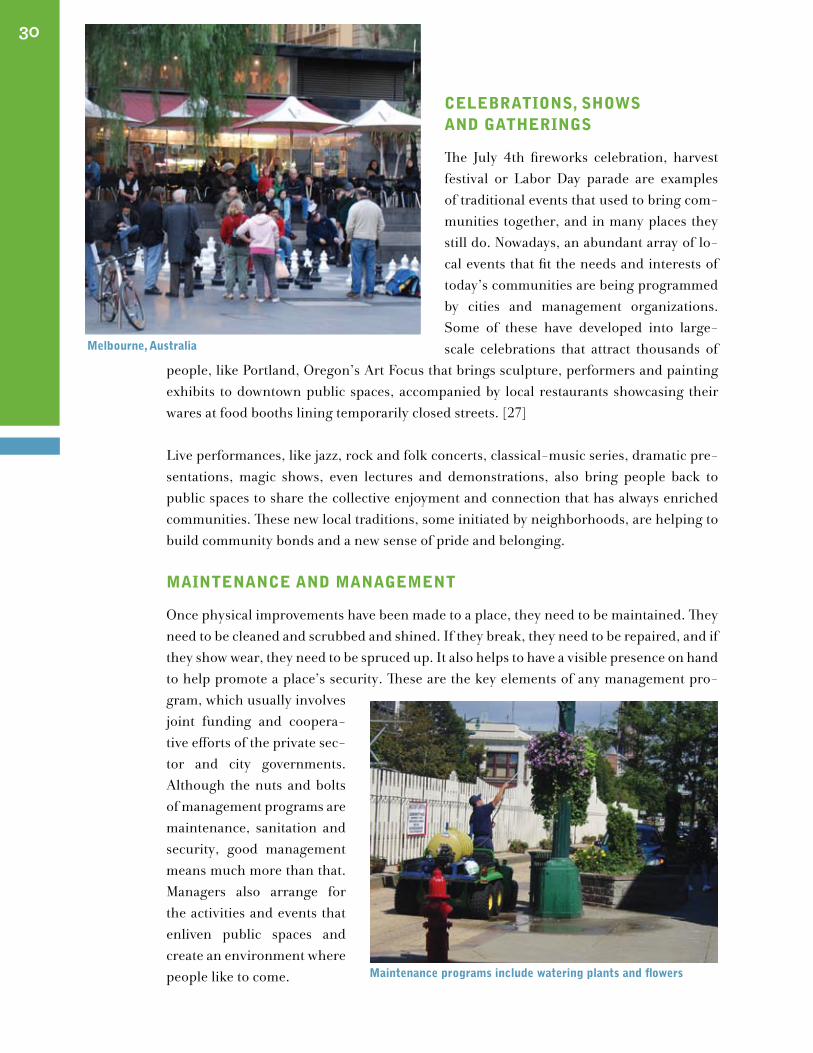
mAIntenAnce And mAnAgement
Once physical improvements have been made to a place, they need to be maintained. They need to be cleaned and scrubbed and shined. If they break, they need to be repaired, and if they show wear, they need to be spruced up. It also helps to have a visible presence on hand to help promote a place’s security. These are the key elements of any management pro-gram, which usually involves joint funding and coopera-tive efforts of the private sec-tor and city governments. Although the nuts and bolts of management programs are maintenance, sanitation and security, good management means much more than that. Managers also arrange for the activities and events that enliven public spaces and create an environment where people like to come.
30
maintenance programs include watering plants and flowers
melbourne, Australia
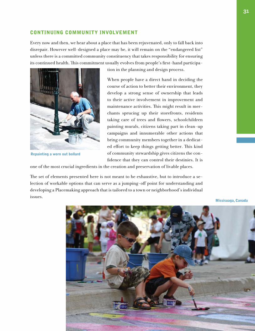
contInuIng communItY InVolVement
Every now and then, we hear about a place that has been rejuvenated, only to fall back into disrepair. However well-designed a place may be, it will remain on the “endangered list” unless there is a committed community constituency that takes responsibility for ensuring its continued health. This commitment usually evolves from people’s first-hand participa-
tion in the planning and design process.
When people have a direct hand in deciding the course of action to better their environment, they develop a strong sense of ownership that leads to their active involvement in improvement and maintenance activities. This might result in mer-chants sprucing up their storefronts, residents taking care of trees and flowers, schoolchildren painting murals, citizens taking part in clean-up campaigns and innumerable other actions that bring community members together in a dedicat-ed effort to keep things getting better. This kind of community stewardship gives citizens the con-fidence that they can control their destinies. It is
one of the most crucial ingredients in the creation and preservation of livable places.
The set of elements presented here is not meant to be exhaustive, but to introduce a se-lection of workable options that can serve as a jumping-off point for understanding and developing a Placemaking approach that is tailored to a town or neighborhood’s individual issues.
missisuaga, canada
31
repainting a worn out bollard
32
ocean Avenue, Belmar, new Jersey
A New Approach for Livable Streets
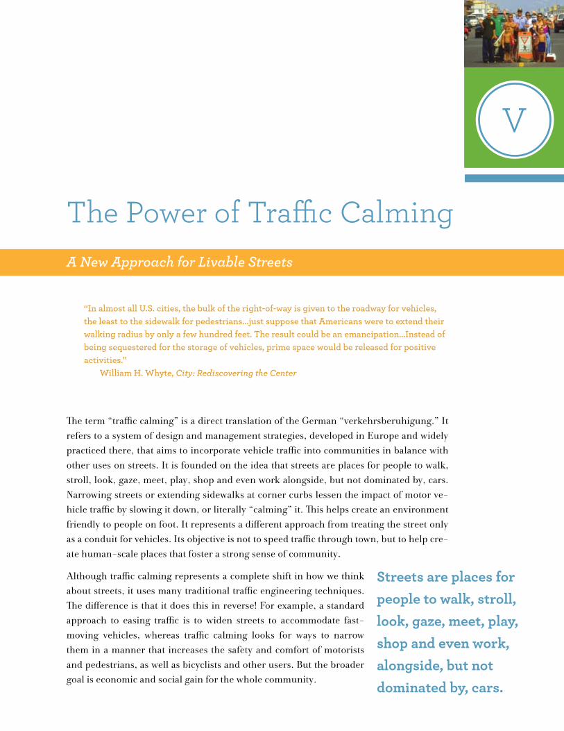
“In almost all U.S. cities, the bulk of the right-of-way is given to the roadway for vehicles, the least to the sidewalk for pedestrians...just suppose that Americans were to extend their walking radius by only a few hundred feet. The result could be an emancipation...Instead of being sequestered for the storage of vehicles, prime space would be released for positive activities.” William H. Whyte, City: Rediscovering the Center
The term “traffic calming” is a direct translation of the German “verkehrsberuhigung.” It refers to a system of design and management strategies, developed in Europe and widely practiced there, that aims to incorporate vehicle traffic into communities in balance with other uses on streets. It is founded on the idea that streets are places for people to walk, stroll, look, gaze, meet, play, shop and even work alongside, but not dominated by, cars. Narrowing streets or extending sidewalks at corner curbs lessen the impact of motor ve-hicle traffic by slowing it down, or literally “calming” it. This helps create an environment friendly to people on foot. It represents a different approach from treating the street only as a conduit for vehicles. Its objective is not to speed traffic through town, but to help cre-ate human-scale places that foster a strong sense of community.
Although traffic calming represents a complete shift in how we think about streets, it uses many traditional traffic engineering techniques. The difference is that it does this in reverse! For example, a standard approach to easing traffic is to widen streets to accommodate fast-moving vehicles, whereas traffic calming looks for ways to narrow them in a manner that increases the safety and comfort of motorists and pedestrians, as well as bicyclists and other users. But the broader goal is economic and social gain for the whole community.
V
Streets are places for people to walk, stroll, look, gaze, meet, play, shop and even work, alongside, but not dominated by, cars.
The Power of Traffic Calming
BIrth of An IngenIous IdeA
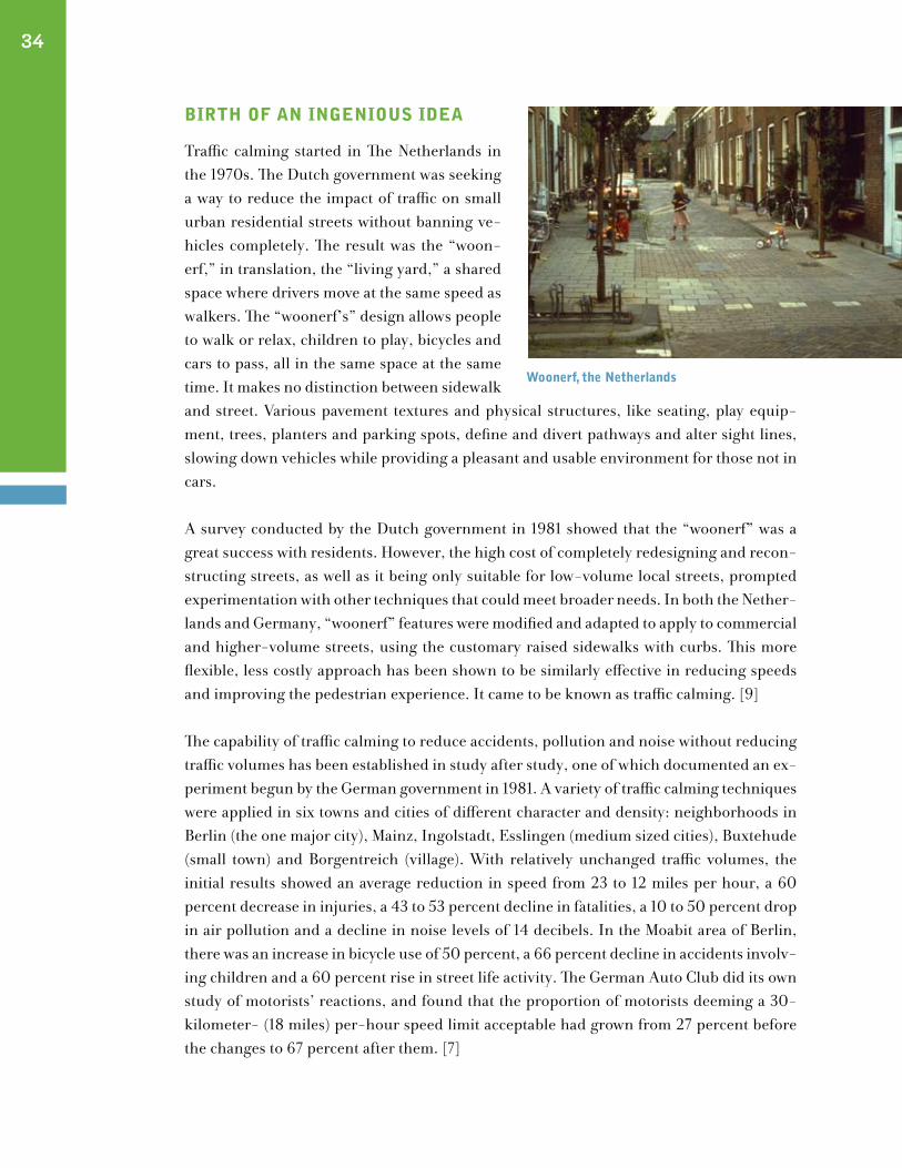
Traffic calming started in The Netherlands in the 1970s. The Dutch government was seeking a way to reduce the impact of traffic on small urban residential streets without banning ve-hicles completely. The result was the “woon-erf,” in translation, the “living yard,” a shared space where drivers move at the same speed as walkers. The “woonerf’s” design allows people to walk or relax, children to play, bicycles and cars to pass, all in the same space at the same time. It makes no distinction between sidewalk and street. Various pavement textures and physical structures, like seating, play equip-ment, trees, planters and parking spots, define and divert pathways and alter sight lines, slowing down vehicles while providing a pleasant and usable environment for those not in cars. A survey conducted by the Dutch government in 1981 showed that the “woonerf” was a great success with residents. However, the high cost of completely redesigning and recon-structing streets, as well as it being only suitable for low-volume local streets, prompted experimentation with other techniques that could meet broader needs. In both the Nether-lands and Germany, “woonerf” features were modified and adapted to apply to commercial and higher-volume streets, using the customary raised sidewalks with curbs. This more flexible, less costly approach has been shown to be similarly effective in reducing speeds and improving the pedestrian experience. It came to be known as traffic calming. [9]
The capability of traffic calming to reduce accidents, pollution and noise without reducing traffic volumes has been established in study after study, one of which documented an ex-periment begun by the German government in 1981. A variety of traffic calming techniques were applied in six towns and cities of different character and density: neighborhoods in Berlin (the one major city), Mainz, Ingolstadt, Esslingen (medium sized cities), Buxtehude (small town) and Borgentreich (village). With relatively unchanged traffic volumes, the initial results showed an average reduction in speed from 23 to 12 miles per hour, a 60 percent decrease in injuries, a 43 to 53 percent decline in fatalities, a 10 to 50 percent drop in air pollution and a decline in noise levels of 14 decibels. In the Moabit area of Berlin, there was an increase in bicycle use of 50 percent, a 66 percent decline in accidents involv-ing children and a 60 percent rise in street life activity. The German Auto Club did its own study of motorists’ reactions, and found that the proportion of motorists deeming a 30-kilometer- (18 miles) per-hour speed limit acceptable had grown from 27 percent before the changes to 67 percent after them. [7]
34
woonerf, the netherlands
woonerf, the netherlands
In the years since, traffic calming has spread around the world. In 1990, for instance, the Danish Government’s Transport Action Plan set forth as a key objective the creation of a traffic system in which accidents, environmental damage and other harmful effects of traffic would be minimized. Guidelines were laid out not only for traffic calming but also defining the design details that can produce specific reduced speeds. The Danes also have been in the forefront of including the public early on in the process of planning traffic calming improvements. [2][3]
At this point there are successful examples of traffic calming in countless European cities and towns, among them Amsterdam, Brussels, Paris, Prague and Stockholm.
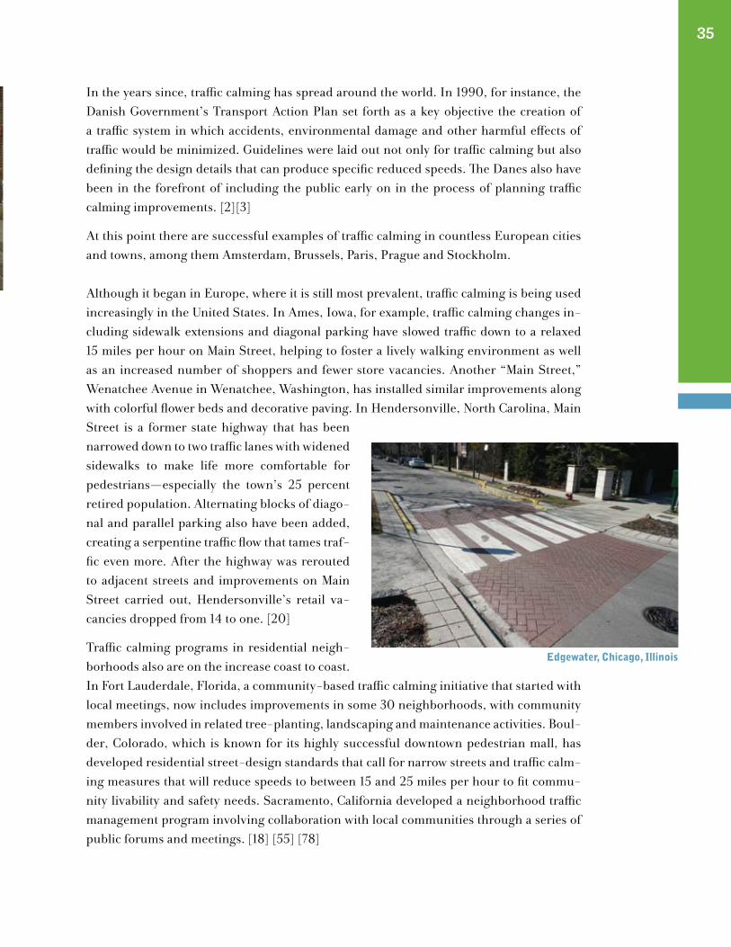
Although it began in Europe, where it is still most prevalent, traffic calming is being used increasingly in the United States. In Ames, Iowa, for example, traffic calming changes in-cluding sidewalk extensions and diagonal parking have slowed traffic down to a relaxed 15 miles per hour on Main Street, helping to foster a lively walking environment as well as an increased number of shoppers and fewer store vacancies. Another “Main Street,” Wenatchee Avenue in Wenatchee, Washington, has installed similar improvements along with colorful flower beds and decorative paving. In Hendersonville, North Carolina, Main Street is a former state highway that has been narrowed down to two traffic lanes with widened sidewalks to make life more comfortable for pedestrians—especially the town’s 25 percent retired population. Alternating blocks of diago-nal and parallel parking also have been added, creating a serpentine traffic flow that tames traf-fic even more. After the highway was rerouted to adjacent streets and improvements on Main Street carried out, Hendersonville’s retail va-cancies dropped from 14 to one. [20]
Traffic calming programs in residential neigh-borhoods also are on the increase coast to coast. In Fort Lauderdale, Florida, a community-based traffic calming initiative that started with local meetings, now includes improvements in some 30 neighborhoods, with community members involved in related tree-planting, landscaping and maintenance activities. Boul-der, Colorado, which is known for its highly successful downtown pedestrian mall, has developed residential street-design standards that call for narrow streets and traffic calm-ing measures that will reduce speeds to between 15 and 25 miles per hour to fit commu-nity livability and safety needs. Sacramento, California developed a neighborhood traffic management program involving collaboration with local communities through a series of public forums and meetings. [18] [55] [78]
35
edgewater, chicago, Illinois

One long-time practitioner of neighborhood-based traffic control is Seattle, Washington, where the Department of Transportation works with local residents to analyze street conditions and experiments with communities in apply-ing a variety of traffic calming solutions, such as curb extensions, chicanes, diverters and traffic circles. Seattle has developed a “Making Streets That Work” educational program, in connection with its comprehensive plan, that further involves people in the improvement of their streets as part of a neighborhood plan-ning effort. [8]
In all of these situations, traffic calming has shown a potential for helping to improve places in ways that go beyond reducing accidents, pollution and noise. Because it reclaims space from vehicles, traffic calming provides an opportunity for greening and other community enhancements. By helping to create a friendlier pedestrian environment, it plays a part in attracting more shoppers and stroll-ers to streets, adding social and economic vitality. The lower traffic speeds allow cyclists to more safely share streets that don’t have special lanes for them. Slower speeds also mean increased safety and confidence for seniors, children and disabled citizens. Finally, traf-fic calming programs are generally community-based, with the public participating in all stages of their development. This give-and-take, side-by-side working out of things is the yeast that builds strong communities and keeps them together.
trAffIc cAlmIng tools
The following are some of the most commonly used traffic calming tools:
Diagonal Parking
This is one of the simplest, most inex-pensive ways to not only change the feel, but also the function of streets. All that’s involved is painting lines on a street. These lines progress from the curb at an angle, with car-width spaces between them. With cars jut-ting out from the curb, diagonal park-ing shortens the in-the-line-of-traffic distance for people crossing the street.
36
Traffic calming has shown a potential for helping to improve
places in ways that go beyond reducing accidents, pollution and
noise. Because it reclaims space from vehicles, traffic calming
provides an opportunity for greening and other
community enhancements.
tallahassee, florida
Merchants like diagonal parking, because it can add as much as 40 percent more parking space than parallel, making it easy for folks to stop and shop. [14]
Back-in angle parking is now becoming popular because it is easier to pull out, it increases the visibility of bicycles, and car doors open to the sidewalk rather than the street.
Converting One-Way to Two-Way Streets
Two-way streets calm traffic and also eliminate the need to drive blocks and blocks out of the way or make extra turns to get to nearby destinations. This translates into less driving. In 1992, Longview, Texas changed its one-way streets downtown back to two-way streets with single face-to-face lanes of traffic and diagonal parking flanking them. At first, just one block was altered, and then a few blocks more. The change was so successful, that the entire eight blocks of Longview’s downtown were converted by 1994. The Downtown Development division of the Longview Partnership reports the following positive results from this change: (1) Traffic access has been improved, because people can get directly to the side of the street where they’re going; (2) Confusion has been reduced, because people don’t have to drive around extra blocks to reach their destinations; (3) Commercial traffic has increased, and so has business, while the speed of traffic has decreased. [74]
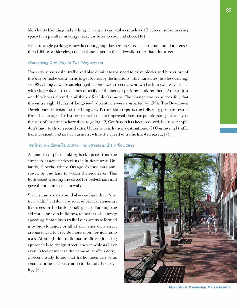
Widening Sidewalks, Narrowing Streets and Traffic Lanes
A good example of taking back space from the street to benefit pedestrians is in downtown Or-lando, Florida, where Orange Avenue was nar-rowed by one lane to widen the sidewalks. This both eased crossing the street for pedestrians and gave them more space to walk.
Streets that are narrowed also can have their “op-tical width” cut down by rows of vertical elements, like trees or bollards (small posts), flanking the sidewalk, or even buildings, to further discourage speeding. Sometimes traffic lanes are transformed into bicycle lanes, or all of the lanes on a street are narrowed to provide more room for non-auto uses. Although the traditional traffic engineering approach is to design street lanes as wide as 12 or even 13 feet or more in the name of “traffic safety,” a recent study found that traffic lanes can be as small as nine feet wide and still be safe for driv-ing. [64]
37
main street, cambridge, massachusetts
38
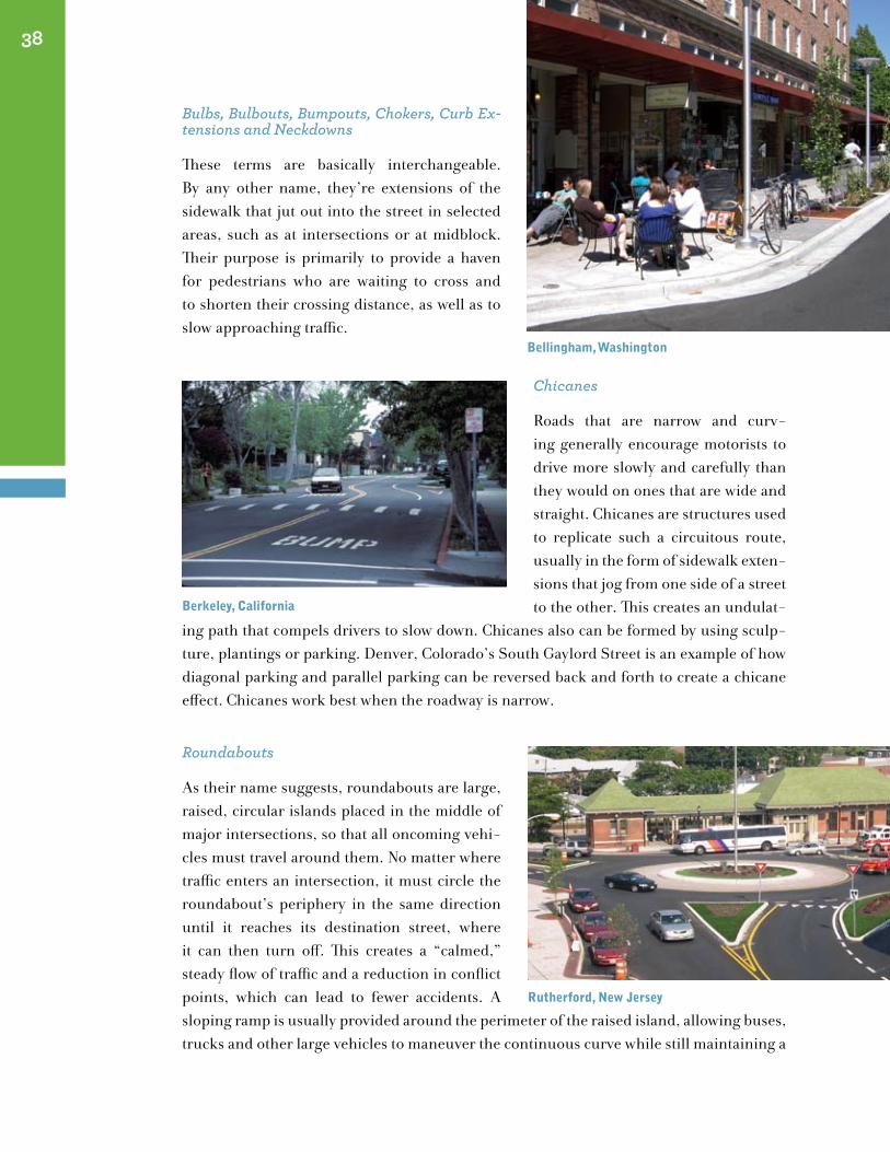
Bulbs, Bulbouts, Bumpouts, Chokers, Curb Ex-tensions and Neckdowns
These terms are basically interchangeable. By any other name, they’re extensions of the sidewalk that jut out into the street in selected areas, such as at intersections or at midblock. Their purpose is primarily to provide a haven for pedestrians who are waiting to cross and to shorten their crossing distance, as well as to slow approaching traffic.
Chicanes
Roads that are narrow and curv-ing generally encourage motorists to drive more slowly and carefully than they would on ones that are wide and straight. Chicanes are structures used to replicate such a circuitous route, usually in the form of sidewalk exten-sions that jog from one side of a street to the other. This creates an undulat-
ing path that compels drivers to slow down. Chicanes also can be formed by using sculp-ture, plantings or parking. Denver, Colorado’s South Gaylord Street is an example of how diagonal parking and parallel parking can be reversed back and forth to create a chicane effect. Chicanes work best when the roadway is narrow.
Roundabouts
As their name suggests, roundabouts are large, raised, circular islands placed in the middle of major intersections, so that all oncoming vehi-cles must travel around them. No matter where traffic enters an intersection, it must circle the roundabout’s periphery in the same direction until it reaches its destination street, where it can then turn off. This creates a “calmed,” steady flow of traffic and a reduction in conflict points, which can lead to fewer accidents. A sloping ramp is usually provided around the perimeter of the raised island, allowing buses, trucks and other large vehicles to maneuver the continuous curve while still maintaining a
Bellingham, washington
Berkeley, california
rutherford, new Jersey
Bellingham, washington
rutherford, new Jersey
lowered speed. Customarily, no traffic signals are used, but traffic control signs are usually prominent.
The new approach to roundabouts involves narrowing streets as they approach the inter-section and installing crosswalks on these approaches at least one car length before reach-ing the circular path. This slows the oncoming vehicles in advance of the entrance to the roundabout and gives pedestrians a safe, clearly marked place to cross. Sometimes, the volume of traffic on its surrounding streets can affect how well a roundabout works, since congested conditions can stop movement in the roundabout. A roundabout is a good place to put a fountain or a piece of sculpture and attractive, abundant landscaping. It can be a striking gateway treatment and break infinite sight lines. [16]
Traffic Circles
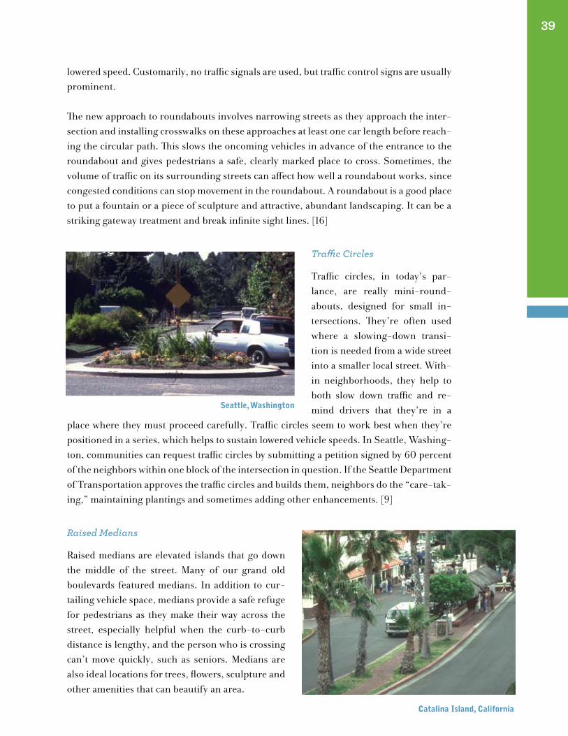
Traffic circles, in today’s par-lance, are really mini-round-abouts, designed for small in-tersections. They’re often used where a slowing-down transi-tion is needed from a wide street into a smaller local street. With-in neighborhoods, they help to both slow down traffic and re-mind drivers that they’re in a
place where they must proceed carefully. Traffic circles seem to work best when they’re positioned in a series, which helps to sustain lowered vehicle speeds. In Seattle, Washing-ton, communities can request traffic circles by submitting a petition signed by 60 percent of the neighbors within one block of the intersection in question. If the Seattle Department of Transportation approves the traffic circles and builds them, neighbors do the “care-tak-ing,” maintaining plantings and sometimes adding other enhancements. [9]
Raised Medians
Raised medians are elevated islands that go down the middle of the street. Many of our grand old boulevards featured medians. In addition to cur-tailing vehicle space, medians provide a safe refuge for pedestrians as they make their way across the street, especially helpful when the curb-to-curb distance is lengthy, and the person who is crossing can’t move quickly, such as seniors. Medians are also ideal locations for trees, flowers, sculpture and other amenities that can beautify an area.
39
seattle, washington
catalina Island, california
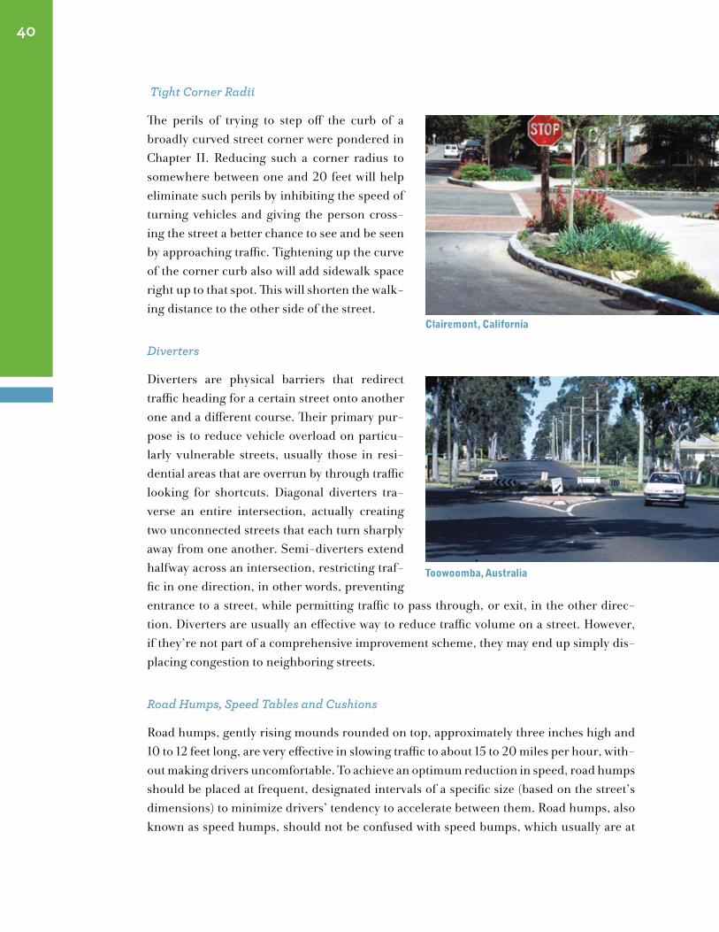
Tight Corner Radii
The perils of trying to step off the curb of a broadly curved street corner were pondered in Chapter II. Reducing such a corner radius to somewhere between one and 20 feet will help eliminate such perils by inhibiting the speed of turning vehicles and giving the person cross-ing the street a better chance to see and be seen by approaching traffic. Tightening up the curve of the corner curb also will add sidewalk space right up to that spot. This will shorten the walk-ing distance to the other side of the street.
Diverters
Diverters are physical barriers that redirect traffic heading for a certain street onto another one and a different course. Their primary pur-pose is to reduce vehicle overload on particu-larly vulnerable streets, usually those in resi-dential areas that are overrun by through traffic looking for shortcuts. Diagonal diverters tra-verse an entire intersection, actually creating two unconnected streets that each turn sharply away from one another. Semi-diverters extend halfway across an intersection, restricting traf-fic in one direction, in other words, preventing entrance to a street, while permitting traffic to pass through, or exit, in the other direc-tion. Diverters are usually an effective way to reduce traffic volume on a street. However, if they’re not part of a comprehensive improvement scheme, they may end up simply dis-placing congestion to neighboring streets.
Road Humps, Speed Tables and Cushions
Road humps, gently rising mounds rounded on top, approximately three inches high and 10 to 12 feet long, are very effective in slowing traffic to about 15 to 20 miles per hour, with-out making drivers uncomfortable. To achieve an optimum reduction in speed, road humps should be placed at frequent, designated intervals of a specific size (based on the street’s dimensions) to minimize drivers’ tendency to accelerate between them. Road humps, also known as speed humps, should not be confused with speed bumps, which usually are at
40
clairemont, california
toowoomba, Australia

clairemont, california
toowoomba, Australia
least five or six inches high and serve as a more abrupt warning to slow down.
Speed tables are longer, flatter versions of road humps. Ordinarily, they are the same width as the street and the same height as the sidewalk, providing safe and comfortable crossings for people walking and in wheelchairs, as well as greater access for snow clearance. Speed tables allow people to conveniently cross the street at the same point where driv-ers must decrease speed dramatically.
Cushions are another traffic-calming element. They are similar to speed humps, but are slightly larger, making it easier for bi-cycles, emergency vehicles, buses and any other large vehicles to use.
Whether with road humps, speed tables or cushions, it is important to highlight these ver-tical shifts in the roadway with markings that clearly delineate them and alert approaching drivers to their presence. This can be accomplished with signs, changes in pavement tex-ture, or painting words and symbols directly on the street. In Berkeley, California, where 120 speed humps have been installed in response to requests by residents, one foot wide white stripes, spaced three feet apart from each other, are painted over the full length of the humps to inform drivers as they approach. Although these are humps, not bumps, a diamond shaped sign that says “Bump”* over a square sign indicating “15 mph” is placed at the side of the street and in advance of the hump. The street’s centerline is painted bright yellow. Sometimes the pavement in front of the hump is marked with the word “Bump”* in large eight-foot-high white letters.
* Using the term “Bump” instead of “Hump” is a standard approach that is thought to effectively put drivers on the alert. [70]
Rumble Strips and Other Surface Treatments
The humble rumble strip is a familiar sight and sound where drivers need advance no-tice that they’re entering territory where they have to be very careful, such as a shopping center with a great number of pedestrians, a freeway with roadwork going on, a school area, or the entrance to a residential neighborhood. Rumble strips are made of materials like granite and concrete roughened by being broken into raised lines or patterns. They’re placed across roadways, usually a few spaced apart, and create a vibration that drivers can lessen only by slowing down. Rumble strips do make noise, so their use should be limited to locations where they won’t be disruptive.
41
Berkeley, california

The job of the rumble strip can usually be accomplished in a more interesting and visually attractive way by a variety of textured paving materials in different sizes, shapes and col-ors, such as bricks or Belgian blocks. In addition to exercising a modest check on vehicle speed, such pavings can define a street from a sidewalk or a parking lane. They can draw drivers’ attention toward a pedestrian crosswalk or a pedestrian haven in the middle of the street. They also can be used to make a street appear narrower than it is, creating a psycho-perceptive illusion that deters speeding. Even if a pavement isn’t textured, changes in its color can also create many of the same effects. For instance, a specific color might signal the beginning of a commercial area or highlight a bicycle path. Pavement textures and col-ors also can contribute to a street’s attractiveness.
whAt You need to know Before You stArt
The “starter set” of techniques to tame traffic outlined above has been shown to be effective in a variety of ways. However, it is important to keep in mind that each one of these tools has its own specific applications, and not every one of them will fit every circumstance. Some of them will be more effective if used in combination with other traffic calming tools or with some of the Placemaking tools discussed in Chapter IV, or with other alternative transportation approaches, like bicycles, buses or light-rail. The best approach may be to use a mix of all of these! It really will depend on what conditions exist and what you’re trying to accomplish. The following is a sampler of the kinds of issues that need to be con-sidered when making traffic calming choices.
• Do emergency and service vehicles use the area? Do school buses?
• Is there a problem with through traffic?
• What are the surrounding uses? Residential? Commercial? Retail? Cultural? Enter-tainment? Civic? Educational? Other?
• Who are the users? Are there many elderly or disabled people or children?
• What kinds of activities are going on in the vicinity or are planned to go on?
• Are there any plans for improving the area? If so, in what way?
42
fredensborg, denmark
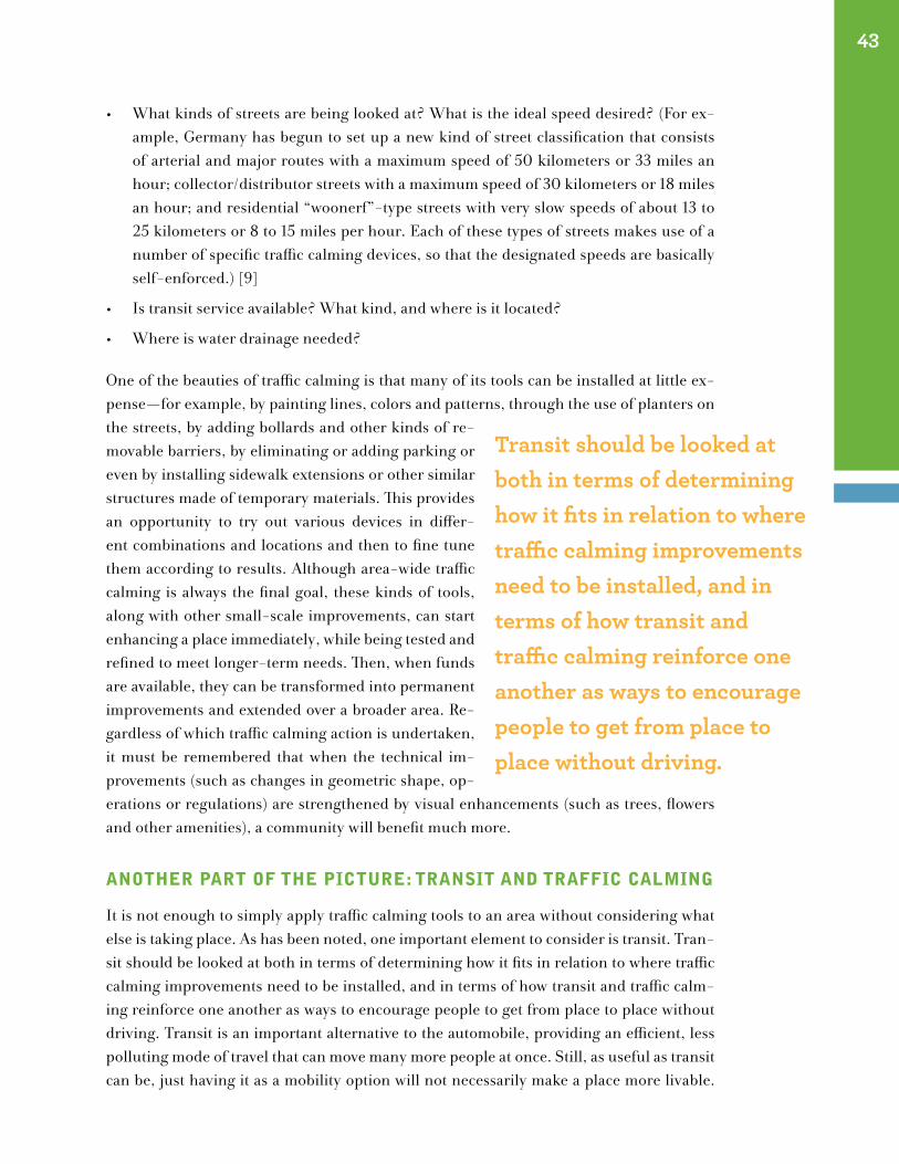
• What kinds of streets are being looked at? What is the ideal speed desired? (For ex-ample, Germany has begun to set up a new kind of street classification that consists of arterial and major routes with a maximum speed of 50 kilometers or 33 miles an hour; collector/distributor streets with a maximum speed of 30 kilometers or 18 miles an hour; and residential “woonerf”-type streets with very slow speeds of about 13 to 25 kilometers or 8 to 15 miles per hour. Each of these types of streets makes use of a number of specific traffic calming devices, so that the designated speeds are basically self-enforced.) [9]
• Is transit service available? What kind, and where is it located?
• Where is water drainage needed?
One of the beauties of traffic calming is that many of its tools can be installed at little ex-pense—for example, by painting lines, colors and patterns, through the use of planters on the streets, by adding bollards and other kinds of re-movable barriers, by eliminating or adding parking or even by installing sidewalk extensions or other similar structures made of temporary materials. This provides an opportunity to try out various devices in differ-ent combinations and locations and then to fine tune them according to results. Although area-wide traffic calming is always the final goal, these kinds of tools, along with other small-scale improvements, can start enhancing a place immediately, while being tested and refined to meet longer-term needs. Then, when funds are available, they can be transformed into permanent improvements and extended over a broader area. Re-gardless of which traffic calming action is undertaken, it must be remembered that when the technical im-provements (such as changes in geometric shape, op-erations or regulations) are strengthened by visual enhancements (such as trees, flowers and other amenities), a community will benefit much more.
Another pArt of the pIcture: trAnsIt And trAffIc cAlmIng
It is not enough to simply apply traffic calming tools to an area without considering what else is taking place. As has been noted, one important element to consider is transit. Tran-sit should be looked at both in terms of determining how it fits in relation to where traffic calming improvements need to be installed, and in terms of how transit and traffic calm-ing reinforce one another as ways to encourage people to get from place to place without driving. Transit is an important alternative to the automobile, providing an efficient, less polluting mode of travel that can move many more people at once. Still, as useful as transit can be, just having it as a mobility option will not necessarily make a place more livable.
43
Transit should be looked at both in terms of determining how it fits in relation to where traffic calming improvements need to be installed, and in terms of how transit and traffic calming reinforce one another as ways to encourage people to get from place to place without driving.
People still need to get across the street safely to reach a train station or bus stop or other transit hub. And they need a pleasant and direct walking route on the way there. This is where traffic calming comes in.
Traffic calming measures, such as sidewalk widening and traffic signal changes, can make walking trips to the transit station more comfortable and convenient, as well as providing new space for amenities that will make the walk even more pleasurable. European coun-tries have understood this for many years, and although the United States lags behind, some cities and towns now are beginning to recognize the value of this approach. In Cor-pus Christi, Texas, for example, the Staples Street bus transfer station across from City Hall creates a pedestrian-friendly environment around the station and area businesses, and the station provides transit links to nearby transit dependent communities. [49] New crosswalks, landscaped medians and lighting also were installed as part of a combined commuter rail station/streetscape enhancement project in downtown Plainfield, New Jer-sey. Other changes, including widened sidewalks and decorative seating integrated the station into adjacent streets.
Although traffic calming and transit share many of the same goals, sometimes they can con-flict. When a traffic calming strategy succeeds at slowing down vehicles, it may be interfer-ing with the efficient movement of a transit vehicle, or rider comfort, as when speed humps cause jostling for bus passengers.There are certain strategies that have been developed to maintain the benefits of traffic calming while allowing transit to function effectively. For instance, cushions, which were discussed earlier, enable buses to pass smoothly over an area, yet still slow smaller vehicles. Bus “bumpouts” or “nubs” are sidewalk extensions in a new guise (see bulbs, chokers and neckdowns, page 34), where buses can pull up without having to move out of the traffic lane. Such nubs extend across the entire parking lane to meet the traffic lane and the bus, giving passengers a safe and accessible way to get on and off, while saving travel time. On Portland, Oregon’s NW 23rd Avenue, a lively neighbor-hood commercial corridor with lots of pedestrians, the nubs accommodate both the front and rear doors of a standard bus. These nubs, which are concrete, are large enough to also have passenger amenities, such as shelters, benches, and waste receptacles. [48]
Patterns of use and activity vary from one street to another. Therefore, every case needs to be examined individually with traffic calmed and transit solutions applied according to the particular circumstances. By and large though, as long as they are coordinated to meet the needs of a specific street environment and its surrounding community, traffic calming and transit work together admirably to provide the comfortable, convenient and safe connec-tions that improve a public place. But transit can play other important roles in Placemak-ing, as we will see in the next chapter.
44
What About Liability?
liability concerns may cause transportation agencies to be reluctant to install the kinds of
street improvements traffic calming entails. In other words, they anticipate that they could be
sued by drivers who might have an accident if certain road design standards that are typically
geared towards facilitating the movement of cars (not pedestrians) are not followed. what
constitutes liability, however, is a murky area and subject to different interpretations that vary
from jurisdiction to jurisdiction.
A case in point was recounted by mayor kenneth pringle of Belmar, new Jersey, who experi-
enced such contradictions in an effort to protect pedestrians. In fact, the Borough of Belmar
was sued by new Jersey’s monmouth county for trying to make ocean Avenue safer to cross.
every summer, throngs of tourists must get across this oceanside thoroughfare to reach Bel-
mar’s beaches, where traffic rarely keeps to the 25-miles-per-hour speed limit. the going is
usually rough. on average, there is a fatal pedestrian/vehicular accident on ocean Avenue ev-
ery two years. the last serious accident, prior to the calming features, was a woman who was
thrown from her wheelchair when hit by a car as she was crossing the street—she survived. It
was this last-straw incident that prompted the mayor and his borough to take action.
Along the middle of ocean Avenue for about a 10-block stretch, in the area with the greatest
pedestrian concentration, they installed a row of 10 orange-and-white construction barrels.
these standard department of transportation plastic barrels, filled with sandbags, were placed
leading up to the busiest intersections. A sign alerted motorists to yield to pedestrians in the
crosswalks, which is an actual requirement of new Jersey law. not only did these devices slow
drivers down and give pedestrians the right-of-way in crosswalks, but people delighted in hav-
ing their pictures taken in front of them (see page 28). motorists who failed to obey the signs
were openly chided by the pedestrians. the barrels were in place during the summer of 1994
and 1995. then the monmouth county counsel requested that the barrels be removed, even
though the intent was to increase pedestrian safety during the peak tourist season.
the county countered that the barrels could obstruct traffic and be hazardous for drivers.
when it was pointed out that Belmar was simply complying with state pedestrian safety
law, the county said that if hit by a speeding motorist, the barricades could fly off and hurt
someone —either way it was a liability! since ocean Avenue is a county road, the mayor agreed
not only to insure the county against damages, but also to sign a letter of indemnification, as
long as the barrels could remain in place during the six days it would take for the Borough
council to approve the letter.
nevertheless, the county sent a truck to Belmar to remove the barrels. when the truck re-
turned empty, the county filed suit. the barrels still remained. finally, the Borough of Belmar
prevailed in superior court, on the grounds that it was trying to enforce state doctrine. A small
caveat in the state law was found that allows any borough in new Jersey to modify any street
in order to protect its citizens, for a period of time up to three months, when warranted by
special circumstances. now, every June, July and August, the barrels return to ocean Avenue to
keep Belmar’s beachgoers safe. [37]
45
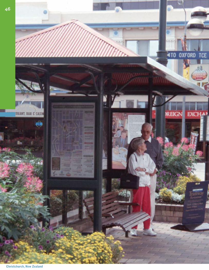
46
christchurch, new Zealand
The Transit ConnectionPutting Place Back on Track
“Railroads tend to build cities—whereas cars tend to destroy them. That’s because a railroad system concentrates life and activity around its stations.” Robert Campbell, Boston Globe
As we’ve noted, transit helps balance street use by providing the opportunity to get from here to there conveniently with-out a car. However, transit also plays an important Placemak-ing role by spurring the kinds of people-friendly, business and community-building activities that help rejuvenate places. In a research project on the role of transit in enhancing community livability, PPS found examples of transit facilities all over the country—bus stops and transfer centers, train depots, light-rail stations, inter-modal terminals—that have become catalysts for community renewal as well as centers of community life and settings for new economic opportunity.
somerVIlle, mAssAchusetts
For example, in 1980, when the Boston area’s Red Line subway was extended from Cam-bridge to Somerville, Massachusetts, its new station provided the incentive to revitalize Davis Square, the commercial center where it was located. The cooperative efforts focused on the station involving state and city agencies, local residents, and business people led to an upgrade of the area’s deteriorating physical environment. This included new office, retail and residential development, the arrival of new restaurants and entertainment fa-
VI
Transit plays an important Placemaking role by spurring the kinds of people-friendly, business and communitybuilding activities that help rejuvenate places.
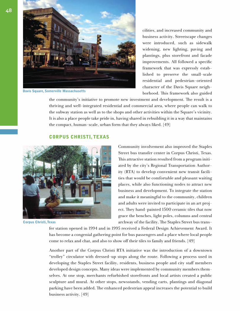
cilities, and increased community and business activity. Streetscape changes were introduced, such as sidewalk widening, new lighting, paving and plantings, plus storefront and facade improvements. All followed a specific framework that was expressly estab-lished to preserve the small-scale residential and pedestrian-oriented character of the Davis Square neigh-borhood. This framework also guided
the community’s initiative to promote new investment and development. The result is a thriving and well-integrated residential and commercial area, where people can walk to the subway station as well as to the shops and other activities within the Square’s vicinity. It is also a place people take pride in, having shared in rebuilding it in a way that maintains the compact, human-scale, urban form that they always liked. [49]
corpus chrIstI, teXAs
Community involvement also improved the Staples Street bus transfer center in Corpus Christi, Texas. This attractive station resulted from a program initi-ated by the city’s Regional Transportation Author-ity (RTA) to develop convenient new transit facili-ties that would be comfortable and pleasant waiting places, while also functioning nodes to attract new business and development. To integrate the station and make it meaningful to the community, children and adults were invited to participate in an art proj-ect. They hand-painted 1500 ceramic tiles that now grace the benches, light poles, columns and central archway of the facility. The Staples Street bus trans-
fer station opened in 1994 and in 1995 received a Federal Design Achievement Award. It has become a congenial gathering point for bus passengers and a place where local people come to relax and chat, and also to show off their tiles to family and friends. [49]
Another part of the Corpus Christi RTA initiative was the introduction of a downtown “trolley” circulator with dressed-up stops along the route. Following a process used in developing the Staples Street facility, residents, business people and city staff members developed design concepts. Many ideas were implemented by community members them-selves. At one stop, merchants refurbished storefronts and local artists created a public sculpture and mural. At other stops, newsstands, vending carts, plantings and diagonal parking have been added. The enhanced pedestrian appeal increases the potential to build business activity. [49]
48
davis square, somerville massachusetts
corpus christi, texas
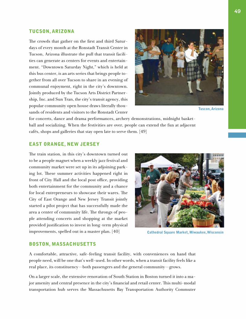
tucson, ArIZonA
The crowds that gather on the first and third Satur-days of every month at the Ronstadt Transit Center in Tucson, Arizona illustrate the pull that transit facili-ties can generate as centers for events and entertain-ment. “Downtown Saturday Night,” which is held at this bus center, is an arts series that brings people to-gether from all over Tucson to share in an evening of communal enjoyment, right in the city’s downtown. Jointly produced by the Tucson Arts District Partner-ship, Inc. and Sun Tran, the city’s transit agency, this popular community open house draws literally thou-sands of residents and visitors to the Ronstadt Center for concerts, dance and drama performances, archery demonstrations, midnight basket-ball and socializing. When the festivities are over, people can extend the fun at adjacent cafés, shops and galleries that stay open late to serve them. [49]
eAst orAnge, new JerseY
The train station, in this city’s downtown turned out to be a people magnet when a weekly jazz festival and community market were set up in its adjoining park-ing lot. These summer activities happened right in front of City Hall and the local post office, providing both entertainment for the community and a chance for local entrepreneurs to showcase their wares. The City of East Orange and New Jersey Transit jointly started a pilot project that has successfully made the area a center of community life. The throngs of peo-ple attending concerts and shopping at the market provided justification to invest in long-term physical improvements, spelled out in a master plan. [40] Boston, mAssAchusetts
A comfortable, attractive, safe-feeling transit facility, with conveniences on hand that people need, will be one that’s well-used. In other words, when a transit facility feels like a real place, its constituency—both passengers and the general community—grows.
On a larger scale, the extensive renovation of South Station in Boston turned it into a ma-jor amenity and central presence in the city’s financial and retail center. This multi-modal transportation hub serves the Massachusetts Bay Transportation Authority Commuter
49
tuscon, Arizona
cathedral square market, miwaukee, wisconsin
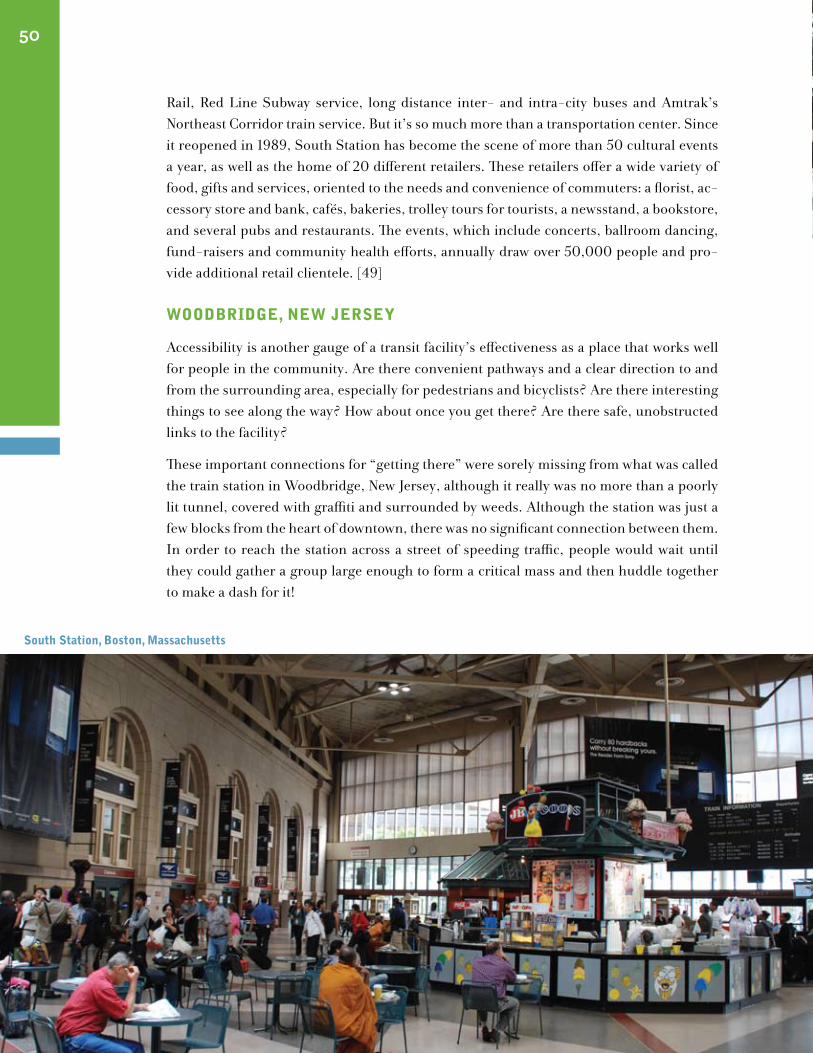
Rail, Red Line Subway service, long distance inter- and intra-city buses and Amtrak’s Northeast Corridor train service. But it’s so much more than a transportation center. Since it reopened in 1989, South Station has become the scene of more than 50 cultural events a year, as well as the home of 20 different retailers. These retailers offer a wide variety of food, gifts and services, oriented to the needs and convenience of commuters: a florist, ac-cessory store and bank, cafés, bakeries, trolley tours for tourists, a newsstand, a bookstore, and several pubs and restaurants. The events, which include concerts, ballroom dancing, fund-raisers and community health efforts, annually draw over 50,000 people and pro-vide additional retail clientele. [49]
woodBrIdge, new JerseY
Accessibility is another gauge of a transit facility’s effectiveness as a place that works well for people in the community. Are there convenient pathways and a clear direction to and from the surrounding area, especially for pedestrians and bicyclists? Are there interesting things to see along the way? How about once you get there? Are there safe, unobstructed links to the facility?
These important connections for “getting there” were sorely missing from what was called the train station in Woodbridge, New Jersey, although it really was no more than a poorly lit tunnel, covered with graffiti and surrounded by weeds. Although the station was just a few blocks from the heart of downtown, there was no significant connection between them. In order to reach the station across a street of speeding traffic, people would wait until they could gather a group large enough to form a critical mass and then huddle together to make a dash for it!
50
south station, Boston, massachusetts
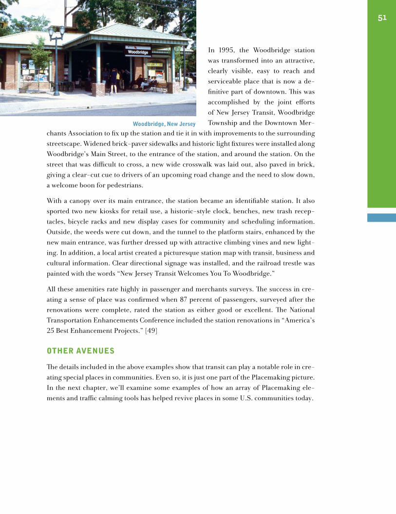
In 1995, the Woodbridge station was transformed into an attractive, clearly visible, easy to reach and serviceable place that is now a de-finitive part of downtown. This was accomplished by the joint efforts of New Jersey Transit, Woodbridge Township and the Downtown Mer-
chants Association to fix up the station and tie it in with improvements to the surrounding streetscape. Widened brick-paver sidewalks and historic light fixtures were installed along Woodbridge’s Main Street, to the entrance of the station, and around the station. On the street that was difficult to cross, a new wide crosswalk was laid out, also paved in brick, giving a clear-cut cue to drivers of an upcoming road change and the need to slow down, a welcome boon for pedestrians.
With a canopy over its main entrance, the station became an identifiable station. It also sported two new kiosks for retail use, a historic-style clock, benches, new trash recep-tacles, bicycle racks and new display cases for community and scheduling information. Outside, the weeds were cut down, and the tunnel to the platform stairs, enhanced by the new main entrance, was further dressed up with attractive climbing vines and new light-ing. In addition, a local artist created a picturesque station map with transit, business and cultural information. Clear directional signage was installed, and the railroad trestle was painted with the words “New Jersey Transit Welcomes You To Woodbridge.”
All these amenities rate highly in passenger and merchants surveys. The success in cre-ating a sense of place was confirmed when 87 percent of passengers, surveyed after the renovations were complete, rated the station as either good or excellent. The National Transportation Enhancements Conference included the station renovations in “America’s 25 Best Enhancement Projects.” [49]
other AVenues
The details included in the above examples show that transit can play a notable role in cre-ating special places in communities. Even so, it is just one part of the Placemaking picture. In the next chapter, we’ll examine some examples of how an array of Placemaking ele-ments and traffic calming tools has helped revive places in some U.S. communities today.
51
woodbridge, new Jersey

48
park(ing) day 2007, new York, new York
52
Taking Action to Make Great Communities
“Preserving the urban fabric, weaving together the treasured old and the needed new, not being afraid to think small–that is what genuine revitalization is all about.” Roberta Brandes Gratz, The Living City
Traffic calming, in partnership with a variety of Placemaking elements, can improve the livability of many types of urban and town environments. The following examples of cities and towns that made use of such improvements to rejuvenate declining areas and restore their sense of community represent a variety of geographical and different-size locales in the United States. Before these areas began to succumb to the automobile, they were vital centers of community life where people lived, worked, shopped and played. They are now reclaiming their original roles and, in doing so, demonstrating the importance not only of restructuring streets and other public spaces to make way for a balance of activities and uses, but also of enhancing them, so that people can enjoy the comfort and feeling of fa-miliarity and identification that give these places a true sense of being “home base.”
portlAnd, oregon
Almost 35 years ago, Portland, Oregon decided to adopt a new kind of downtown plan to reverse the ravages of urban sprawl and an ever-growing influx of traffic. Instead of pur-suing prevailing policy, which was to plan for more accommodating automobiles, Port-land veered away from further road building and widening and concentrated on creating a lively and livable walking environment. Its innovative plan and some of its results, such as Pioneer Courthouse Square and Tom McCall Waterfront Park, have been mentioned in previous chapters. These and similar success stories have been achieved by going against the auto-centric grain, making Portland one of the most livable cities in the United States today.
VII
Putting it Together
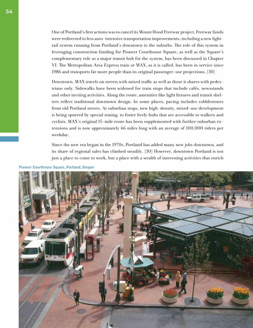
One of Portland’s first actions was to cancel its Mount Hood Freeway project. Freeway funds were redirected to less auto-intensive transportation improvements, including a new light-rail system running from Portland’s downtown to the suburbs. The role of this system in leveraging construction funding for Pioneer Courthouse Square, as well as the Square’s complementary role as a major transit hub for the system, has been discussed in Chapter VI. The Metropolitan Area Express train or MAX, as it is called, has been in service since 1986 and transports far more people than its original passenger-use projections. [30]
Downtown, MAX travels on streets with mixed traffic as well as those it shares with pedes-trians only. Sidewalks have been widened for train stops that include cafés, newsstands and other inviting activities. Along the route, amenities like light fixtures and transit shel-ters reflect traditional downtown design. In some places, paving includes cobblestones from old Portland streets. At suburban stops, new high-density, mixed-use development is being spurred by special zoning, to foster lively hubs that are accessible to walkers and cyclists. MAX’s original 15-mile route has been supplemented with further suburban ex-tensions and is now approximately 66 miles long with an average of 100,000 riders per weekday.
Since the new era began in the 1970s, Portland has added many new jobs downtown, and its share of regional sales has climbed steadily. [30] However, downtown Portland is not just a place to come to work, but a place with a wealth of interesting activities that enrich
54
pioneer courthouse square, portland, oregon
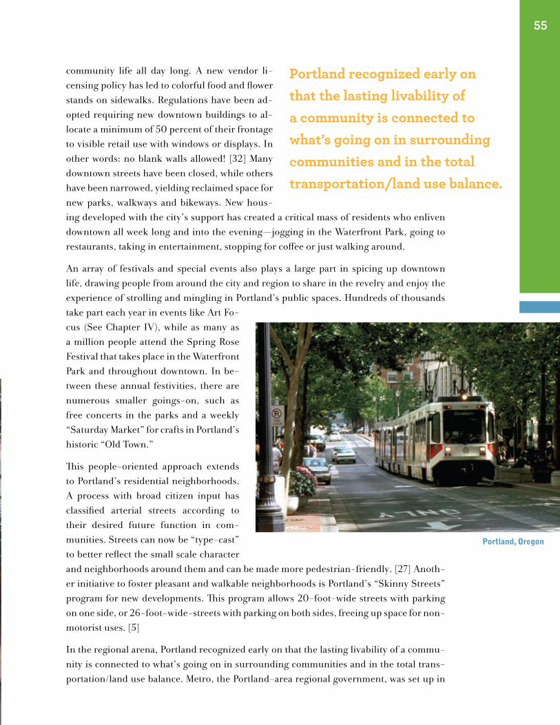
community life all day long. A new vendor li-censing policy has led to colorful food and flower stands on sidewalks. Regulations have been ad-opted requiring new downtown buildings to al-locate a minimum of 50 percent of their frontage to visible retail use with windows or displays. In other words: no blank walls allowed! [32] Many downtown streets have been closed, while others have been narrowed, yielding reclaimed space for new parks, walkways and bikeways. New hous-ing developed with the city’s support has created a critical mass of residents who enliven downtown all week long and into the evening—jogging in the Waterfront Park, going to restaurants, taking in entertainment, stopping for coffee or just walking around.
An array of festivals and special events also plays a large part in spicing up downtown life, drawing people from around the city and region to share in the revelry and enjoy the experience of strolling and mingling in Portland’s public spaces. Hundreds of thousands take part each year in events like Art Fo-cus (See Chapter IV), while as many as a million people attend the Spring Rose Festival that takes place in the Waterfront Park and throughout downtown. In be-tween these annual festivities, there are numerous smaller goings-on, such as free concerts in the parks and a weekly “Saturday Market” for crafts in Portland’s historic “Old Town.”
This people-oriented approach extends to Portland’s residential neighborhoods. A process with broad citizen input has classified arterial streets according to their desired future function in com-munities. Streets can now be “type-cast” to better reflect the small scale character and neighborhoods around them and can be made more pedestrian-friendly. [27] Anoth-er initiative to foster pleasant and walkable neighborhoods is Portland’s “Skinny Streets” program for new developments. This program allows 20-foot-wide streets with parking on one side, or 26-foot-wide-streets with parking on both sides, freeing up space for non-motorist uses. [5]
In the regional arena, Portland recognized early on that the lasting livability of a commu-nity is connected to what’s going on in surrounding communities and in the total trans-portation/land use balance. Metro, the Portland-area regional government, was set up in
55
Portland recognized early on that the lasting livability of a community is connected to what’s going on in surrounding communities and in the total transportation/land use balance.
portland, oregon
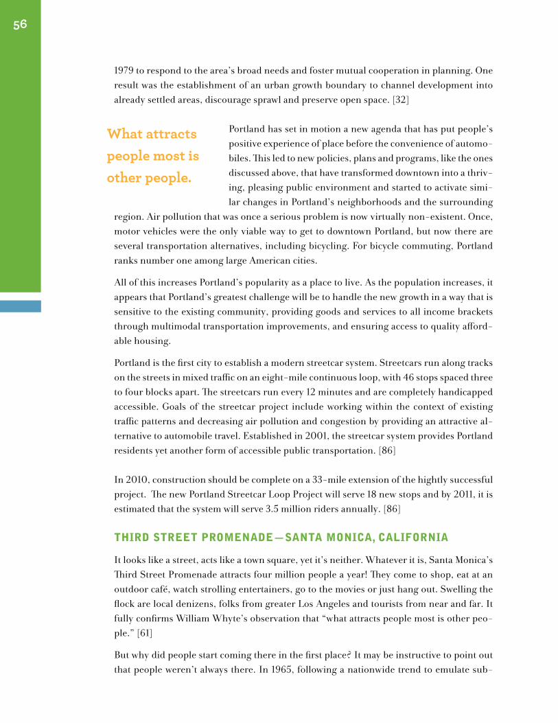
1979 to respond to the area’s broad needs and foster mutual cooperation in planning. One result was the establishment of an urban growth boundary to channel development into already settled areas, discourage sprawl and preserve open space. [32]
Portland has set in motion a new agenda that has put people’s positive experience of place before the convenience of automo-biles. This led to new policies, plans and programs, like the ones discussed above, that have transformed downtown into a thriv-ing, pleasing public environment and started to activate simi-lar changes in Portland’s neighborhoods and the surrounding
region. Air pollution that was once a serious problem is now virtually non-existent. Once, motor vehicles were the only viable way to get to downtown Portland, but now there are several transportation alternatives, including bicycling. For bicycle commuting, Portland ranks number one among large American cities.
All of this increases Portland’s popularity as a place to live. As the population increases, it appears that Portland’s greatest challenge will be to handle the new growth in a way that is sensitive to the existing community, providing goods and services to all income brackets through multimodal transportation improvements, and ensuring access to quality afford-able housing.
Portland is the first city to establish a modern streetcar system. Streetcars run along tracks on the streets in mixed traffic on an eight-mile continuous loop, with 46 stops spaced three to four blocks apart. The streetcars run every 12 minutes and are completely handicapped accessible. Goals of the streetcar project include working within the context of existing traffic patterns and decreasing air pollution and congestion by providing an attractive al-ternative to automobile travel. Established in 2001, the streetcar system provides Portland residents yet another form of accessible public transportation. [86]
In 2010, construction should be complete on a 33-mile extension of the hightly successful project. The new Portland Streetcar Loop Project will serve 18 new stops and by 2011, it is estimated that the system will serve 3.5 million riders annually. [86]
thIrd street promenAde —sAntA monIcA, cAlIfornIA
It looks like a street, acts like a town square, yet it’s neither. Whatever it is, Santa Monica’s Third Street Promenade attracts four million people a year! They come to shop, eat at an outdoor café, watch strolling entertainers, go to the movies or just hang out. Swelling the flock are local denizens, folks from greater Los Angeles and tourists from near and far. It fully confirms William Whyte’s observation that “what attracts people most is other peo-ple.” [61]
But why did people start coming there in the first place? It may be instructive to point out that people weren’t always there. In 1965, following a nationwide trend to emulate sub-
56
What attracts people most is other people.
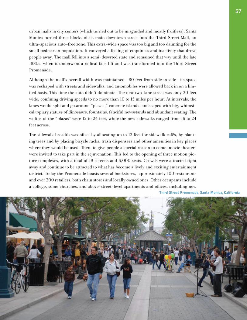
urban malls in city centers (which turned out to be misguided and mostly fruitless), Santa Monica turned three blocks of its main downtown street into the Third Street Mall, an ultra-spacious auto-free zone. This extra-wide space was too big and too daunting for the small pedestrian population. It conveyed a feeling of emptiness and inactivity that drove people away. The mall fell into a semi-deserted state and remained that way until the late 1980s, when it underwent a radical face lift and was transformed into the Third Street Promenade.
Although the mall’s overall width was maintained—80 feet from side to side—its space was reshaped with streets and sidewalks, and automobiles were allowed back in on a lim-ited basis. This time the auto didn’t dominate. The new two-lane street was only 20 feet wide, confining driving speeds to no more than 10 to 15 miles per hour. At intervals, the lanes would split and go around “plazas,” concrete islands landscaped with big, whimsi-cal topiary statues of dinosaurs, fountains, fanciful newsstands and abundant seating. The widths of the “plazas” were 12 to 24 feet, while the new sidewalks ranged from 16 to 24 feet across.
The sidewalk breadth was offset by allocating up to 12 feet for sidewalk cafés, by plant-ing trees and by placing bicycle racks, trash dispensers and other amenities in key places where they would be used. Then, to give people a special reason to come, movie theaters were invited to take part in the rejuvenation. This led to the opening of three motion pic-ture complexes, with a total of 19 screens and 6,000 seats. Crowds were attracted right away and continue to be attracted to what has become a lively and exciting entertainment district. Today the Promenade boasts several bookstores, approximately 100 restaurants and over 200 retailers, both chain stores and locally owned ones. Other occupants include a college, some churches, and above-street-level apartments and offices, including new
57
third street promenade, santa monica, california
film production studios. Sidewalk artists, street performers and push carts are out every day, and a large farmers market is busy on Wednesdays and Saturdays.
Another important part of this renewal has been the establishment of the Bayside Dis-trict Corporation. This non-profit management arm works in partnership with the City of Santa Monica to oversee the operation of not only the Promenade, but also neighboring, and fully trafficked, Second and Fourth Streets. Maintenance and security of this “Bayside District” are handled by the city, based on the management corporation’s recommenda-tions. The corporation also guides the district’s small events, such as food festivals, music performances, and book fairs. Although Second and Fourth Streets continue to allow car traffic, visual connections tie them closer to Third Street.
In 1989, when the Third Street Promenade first opened, a system of flexible car use was in-troduced that gave entry to motorists at times when pedestrians were few and far between. Now the pedestrian influx is so great that, except for emergency access, traffic has been banned completely. [25] [83] [42]
dunedIn, florIdA
“Welcome to Dunedin - 15 mph speed zone.” This is the sign that greets you as you’re about to enter Main Street in this small West Florida town. The textured wood sign and a smaller one beyond it, repeating the speed limit, are not all that greet you. A handsome red brick wall, joined by two more that frame the outsides of the two traffic lanes, act as a gateway, or more aptly, signal that you’re about to experience a special place. Once beyond these walls, you find that they extend into short medians, with colorful flowers and trees that are followed by a series of other similar planted islands.
Dunedin’s special speed designation emulates the 30-kilometer zone common in several European countries. In addition, there is diagonal parking on alternating blocks, creating a zigzag pattern that cars must carefully navigate. Landscaped neckdowns jut out at the street corners and midblock, in line with the staggered parking and reinforcing the sharp bends in the street. The street’s design actually self-enforces the speed limit. There is no doubt that this is an environment that caters to walkers.
Walking is made even more agreeable by attractive, comfortable and well-coordinated amenities, such as special lamppost-style lighting, rustic wooden signage on wooden poles and weather proof benches made of recycled plastic that looks like wood. There are also bicycle racks, with more now being added, to accommodate the ever-increasing numbers of cyclists (as many as 1,300 on a weekend) arriving via the Pinellas Trail, an extended bi-cycle/pedestrian path that intersects Main Street.
Where vacancies once existed along Main Street, there are now restaurants, clothing stores and specialty shops. Dunedin also has become known as a center for antiques; several
58

antique shops grace the street, and two antique fairs are held yearly. The community redevelopment agency re-ports that since the changes were made, more and more local and area residents, as well as tourists, are frequent-ing Main Street as a shopping alternative to the typical suburban mall. The street’s mix also includes a church, several offices, a daycare center and enough businesses providing day-to-day services that nearby residents can take care of most of their needs without going elsewhere. Many people live on surrounding blocks. They can eas-ily walk over to shop, and many of them do this. Efforts to improve Main Street began in 1990 in reaction to an overabundance of through traffic that was adding nothing but congestion. Businesses had been hurting, and merchants were eager to make changes to enhance the area. As the project got under way, a Community Redevelopment Advisory Committee composed of pro-fessionals, business owners and citizens was established.
The Downtown Merchants Association supplemented the improvements by sprucing up many of their own storefronts. The merchants and the Community Redevelopment Agency co-sponsor several events a year, including the antiques fairs, two arts and crafts fairs, a “Mardi Gras,” a “Dunedin Wines the Blues” festival and an “Old-Fashioned Christmas.” Each of these events draw as many as 20,000 people.
Before the improvements were completed in 1992, commercial building occupancy rates were only 80 percent, but business has increased and ground-floor commercial space is now in high demand. More people walk and overall there are fewer people just passing through, and more are there specifically to shop, dine and walk around. Dunedin’s Main Street is now considered both a destination point on the Pinellas Trail and a town center where people can socialize and be part of an active community environment. [73] [79]
college/chApel dIstrIct—new hAVen, connectIcut
At the southern border of Yale University sits a small neighborhood that belies the com-mon image of New Haven as a struggling inner city. This enclave, referred to as the Col-lege/Chapel District, encompasses two pleasant, people-filled blocks with a lively diversi-fied environment. The traditional look and feel of this downtown area gives the impression that it has existed this way for many, many years. Actually, its condition today is primarily the result of the efforts of one private developer, working in cooperation with the City.
Until the early 1960s, the area was considered to be one of the most popular places in town, with several theaters and shops, as well as a residential population, but by the early
59
dunedin, florida
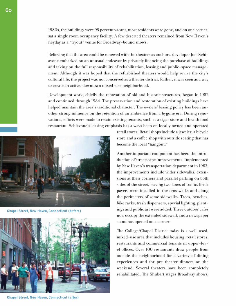
1980s, the buildings were 95 percent vacant, most residents were gone, and on one corner, sat a single room occupancy facility. A few deserted theaters remained from New Haven’s heyday as a “tryout” venue for Broadway-bound shows.
Believing that the area could be renewed with the theaters as anchors, developer Joel Schi-avone embarked on an unusual endeavor by privately financing the purchase of buildings and taking on the full responsibility of rehabilitation, leasing and public-space manage-ment. Although it was hoped that the refurbished theaters would help revive the city’s cultural life, the project was not conceived as a theater district. Rather, it was seen as a way to create an active, downtown mixed-use neighborhood.
Development work, chiefly the renovation of old and historic structures, began in 1982 and continued through 1984. The preservation and restoration of existing buildings have helped maintain the area’s traditional character. The owners’ leasing policy has been an-other strong influence on the retention of an ambience from a bygone era. During reno-vations, efforts were made to retain existing tenants, such as a cigar store and health food restaurant. Schiavone’s leasing emphasis has always been on locally owned and operated
retail stores. Retail shops include a jeweler, a bicycle store and a coffee shop with outside seating that has become the local “hangout.”
Another important component has been the intro-duction of streetscape improvements. Implemented by New Haven’s transportation department in 1983, the improvements include wider sidewalks, exten-sions at their corners and parallel parking on both sides of the street, leaving two lanes of traffic. Brick pavers were installed in the crosswalks and along the perimeters of some sidewalks. Trees, benches, bike racks, trash dispensers, special lighting, plant-ings and public art were added. Three outdoor cafés now occupy the extended sidewalk and a newspaper stand has opened on a corner.
The College/Chapel District today is a well-used, mixed-use area that includes housing, retail stores, restaurants and commercial tenants in upper-lev-el offices. Over 100 restaurants draw people from outside the neighborhood for a variety of dining experiences and for pre-theater dinners on the weekend. Several theaters have been completely rehabilitated. The Shubert stages Broadway shows,
60
chapel street, new haven, connecticut (before)
chapel street, new haven, connecticut (after)
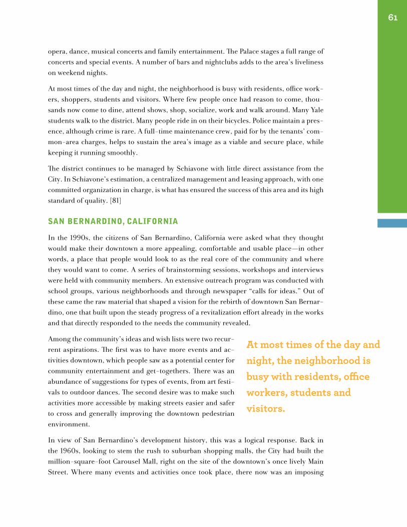
opera, dance, musical concerts and family entertainment. The Palace stages a full range of concerts and special events. A number of bars and nightclubs adds to the area’s liveliness on weekend nights.
At most times of the day and night, the neighborhood is busy with residents, office work-ers, shoppers, students and visitors. Where few people once had reason to come, thou-sands now come to dine, attend shows, shop, socialize, work and walk around. Many Yale students walk to the district. Many people ride in on their bicycles. Police maintain a pres-ence, although crime is rare. A full-time maintenance crew, paid for by the tenants’ com-mon-area charges, helps to sustain the area’s image as a viable and secure place, while keeping it running smoothly.
The district continues to be managed by Schiavone with little direct assistance from the City. In Schiavone’s estimation, a centralized management and leasing approach, with one committed organization in charge, is what has ensured the success of this area and its high standard of quality. [81]
sAn BernArdIno, cAlIfornIA
In the 1990s, the citizens of San Bernardino, California were asked what they thought would make their downtown a more appealing, comfortable and usable place—in other words, a place that people would look to as the real core of the community and where they would want to come. A series of brainstorming sessions, workshops and interviews were held with community members. An extensive outreach program was conducted with school groups, various neighborhoods and through newspaper “calls for ideas.” Out of these came the raw material that shaped a vision for the rebirth of downtown San Bernar-dino, one that built upon the steady progress of a revitalization effort already in the works and that directly responded to the needs the community revealed.
Among the community’s ideas and wish lists were two recur-rent aspirations. The first was to have more events and ac-tivities downtown, which people saw as a potential center for community entertainment and get-togethers. There was an abundance of suggestions for types of events, from art festi-vals to outdoor dances. The second desire was to make such activities more accessible by making streets easier and safer to cross and generally improving the downtown pedestrian environment.
In view of San Bernardino’s development history, this was a logical response. Back in the 1960s, looking to stem the rush to suburban shopping malls, the City had built the million-square-foot Carousel Mall, right on the site of the downtown’s once lively Main Street. Where many events and activities once took place, there now was an imposing
61
At most times of the day and night, the neighborhood is busy with residents, office workers, students and visitors.
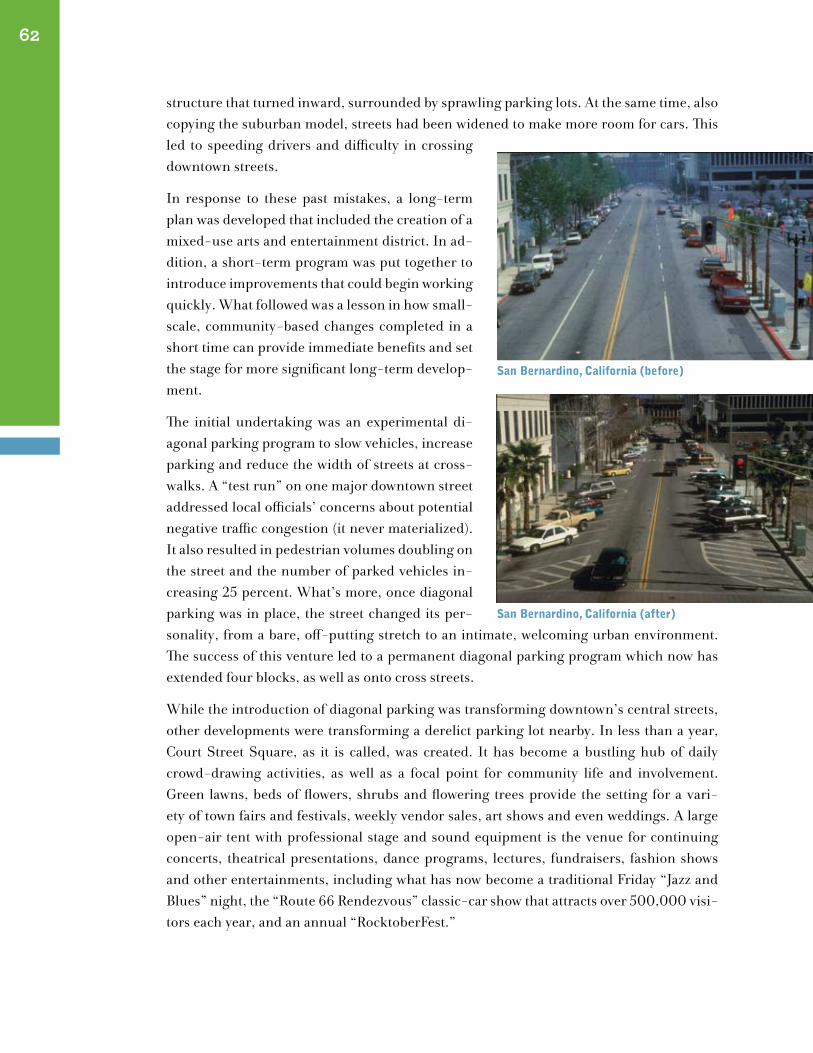
structure that turned inward, surrounded by sprawling parking lots. At the same time, also copying the suburban model, streets had been widened to make more room for cars. This led to speeding drivers and difficulty in crossing downtown streets.
In response to these past mistakes, a long-term plan was developed that included the creation of a mixed-use arts and entertainment district. In ad-dition, a short-term program was put together to introduce improvements that could begin working quickly. What followed was a lesson in how small-scale, community-based changes completed in a short time can provide immediate benefits and set the stage for more significant long-term develop-ment.
The initial undertaking was an experimental di-agonal parking program to slow vehicles, increase parking and reduce the width of streets at cross-walks. A “test run” on one major downtown street addressed local officials’ concerns about potential negative traffic congestion (it never materialized). It also resulted in pedestrian volumes doubling on the street and the number of parked vehicles in-creasing 25 percent. What’s more, once diagonal parking was in place, the street changed its per-sonality, from a bare, off-putting stretch to an intimate, welcoming urban environment. The success of this venture led to a permanent diagonal parking program which now has extended four blocks, as well as onto cross streets.
While the introduction of diagonal parking was transforming downtown’s central streets, other developments were transforming a derelict parking lot nearby. In less than a year, Court Street Square, as it is called, was created. It has become a bustling hub of daily crowd-drawing activities, as well as a focal point for community life and involvement. Green lawns, beds of flowers, shrubs and flowering trees provide the setting for a vari-ety of town fairs and festivals, weekly vendor sales, art shows and even weddings. A large open-air tent with professional stage and sound equipment is the venue for continuing concerts, theatrical presentations, dance programs, lectures, fundraisers, fashion shows and other entertainments, including what has now become a traditional Friday “Jazz and Blues” night, the “Route 66 Rendezvous” classic-car show that attracts over 500,000 visi-tors each year, and an annual “RocktoberFest.”
62
san Bernardino, california (before)
san Bernardino, california (after)
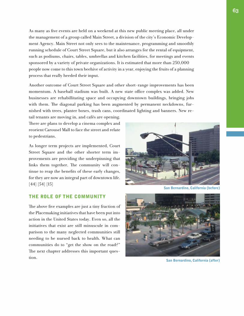
san Bernardino, california (before)
san Bernardino, california (after)
63
As many as five events are held on a weekend at this new public meeting place, all under the management of a group called Main Street, a division of the city’s Economic Develop-ment Agency. Main Street not only sees to the maintenance, programming and smoothly running schedule of Court Street Square, but it also arranges for the rental of equipment, such as podiums, chairs, tables, umbrellas and kitchen facilities, for meetings and events sponsored by a variety of private organizations. It is estimated that more than 250,000people now come to this town beehive of activity in a year, enjoying the fruits of a planning process that really heeded their input.
Another outcome of Court Street Square and other short-range improvements has been momentum. A baseball stadium was built. A new state office complex was added. New businesses are rehabillitating space and occupying downtown buildings, bringing jobs with them. The diagonal parking has been augmented by permanent neckdowns, fur-nished with trees, planter boxes, trash cans, coordinated lighting and banners. New re-tail tenants are moving in, and cafés are opening. There are plans to develop a cinema complex and reorient Carousel Mall to face the street and relate to pedestrians.
As longer term projects are implemented, Court Street Square and the other shorter term im-provements are providing the underpinning that links them together. The community will con-tinue to reap the benefits of these early changes, for they are now an integral part of downtown life. [44] [54] [15]
the role of the communItY
The above five examples are just a tiny fraction of the Placemaking initiatives that have been put into action in the United States today. Even so, all the initiatives that exist are still minuscule in com-parison to the many neglected communities still needing to be nursed back to health. What can communities do to “get the show on the road?” The next chapter addresses this important ques-tion.
san Bernardino, california (before)
san Bernardino, california (after)
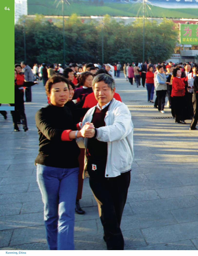
64
kunming, china
Taking Steps To ChangeDirections
How To Turn a Community Around
“Where there is no vision, the people perish.” The Bible: Proverbs 29:18
moBIlIZIng for ActIon
In the previous pages, we’ve seen that it is possible to rejuvenate our communities with livable, human-scale, streets that act as places that provide a healthy balance between pedestrians and vehicles that are inviting and comfortable for everyone who uses them. Creating such community-friendly environments calls for two essential ingredients:
1. teamwork The cooperative efforts of diverse groups and interests in a community are necessary to ensure that varying concerns are addressed, to help smooth out any differ-ences that might arise and to engage community energy and skills. This will require the hard work and dedication of everyone taking part, as well as the emergence of mutual trust, an openness to new ideas and a willingness to share responsibility.
2. community-based Planning Process A process is needed in which the community par-ticipates from the start and is involved in all the steps along the way, for developing and implementing the community’s vision of what a place should be and what improvements will get it there.
The central starting point for a planning improvement in any community should be the people of the community, although this is still a new idea in community development circles. The people who live, work, go to school or otherwise spend significant time in the community are the world’s experts on how things work locally. Because they are there everyday, they know what’s actually going on and can provide small details and insights
VIII
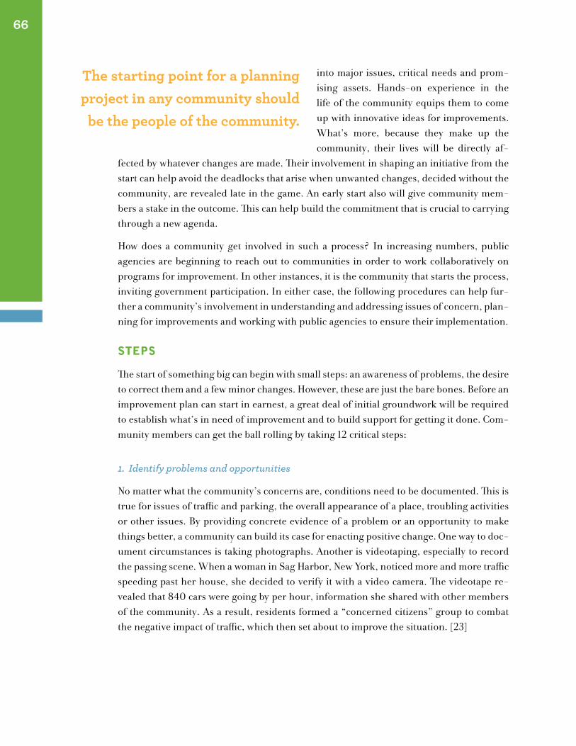
into major issues, critical needs and prom-ising assets. Hands-on experience in the life of the community equips them to come up with innovative ideas for improvements. What’s more, because they make up the community, their lives will be directly af-
fected by whatever changes are made. Their involvement in shaping an initiative from the start can help avoid the deadlocks that arise when unwanted changes, decided without the community, are revealed late in the game. An early start also will give community mem-bers a stake in the outcome. This can help build the commitment that is crucial to carrying through a new agenda.
How does a community get involved in such a process? In increasing numbers, public agencies are beginning to reach out to communities in order to work collaboratively on programs for improvement. In other instances, it is the community that starts the process, inviting government participation. In either case, the following procedures can help fur-ther a community’s involvement in understanding and addressing issues of concern, plan-ning for improvements and working with public agencies to ensure their implementation.
steps
The start of something big can begin with small steps: an awareness of problems, the desire to correct them and a few minor changes. However, these are just the bare bones. Before an improvement plan can start in earnest, a great deal of initial groundwork will be required to establish what’s in need of improvement and to build support for getting it done. Com-munity members can get the ball rolling by taking 12 critical steps:
1. Identify problems and opportunities
No matter what the community’s concerns are, conditions need to be documented. This is true for issues of traffic and parking, the overall appearance of a place, troubling activities or other issues. By providing concrete evidence of a problem or an opportunity to make things better, a community can build its case for enacting positive change. One way to doc-ument circumstances is taking photographs. Another is videotaping, especially to record the passing scene. When a woman in Sag Harbor, New York, noticed more and more traffic speeding past her house, she decided to verify it with a video camera. The videotape re-vealed that 840 cars were going by per hour, information she shared with other members of the community. As a result, residents formed a “concerned citizens” group to combat the negative impact of traffic, which then set about to improve the situation. [23]
66
The starting point for a planning project in any community should
be the people of the community.
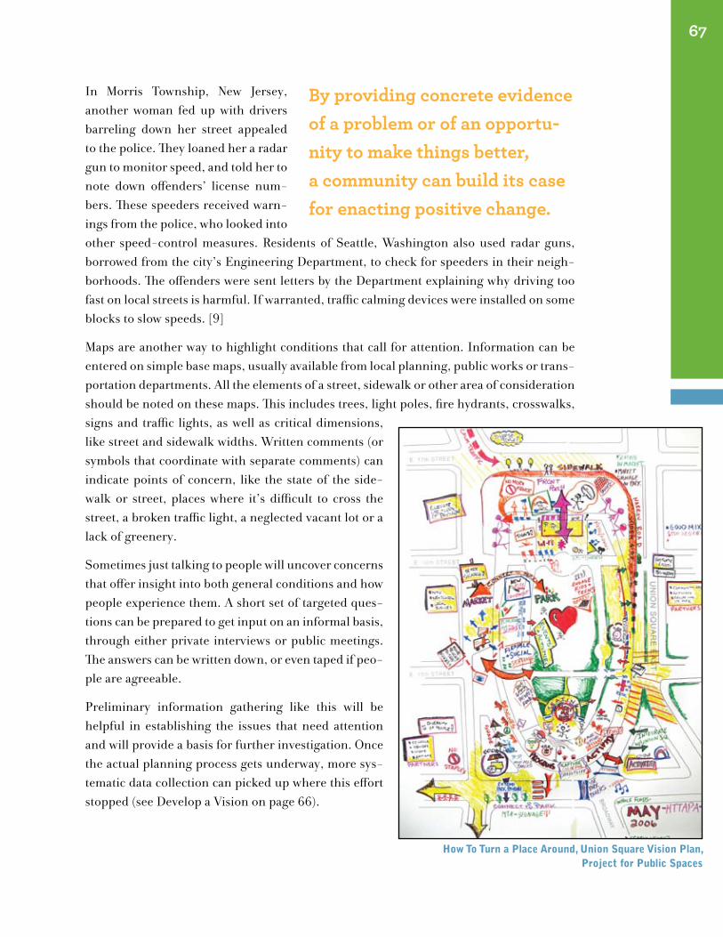
In Morris Township, New Jersey, another woman fed up with drivers barreling down her street appealed to the police. They loaned her a radar gun to monitor speed, and told her to note down offenders’ license num-bers. These speeders received warn-ings from the police, who looked into other speed-control measures. Residents of Seattle, Washington also used radar guns, borrowed from the city’s Engineering Department, to check for speeders in their neigh-borhoods. The offenders were sent letters by the Department explaining why driving too fast on local streets is harmful. If warranted, traffic calming devices were installed on some blocks to slow speeds. [9]
Maps are another way to highlight conditions that call for attention. Information can be entered on simple base maps, usually available from local planning, public works or trans-portation departments. All the elements of a street, sidewalk or other area of consideration should be noted on these maps. This includes trees, light poles, fire hydrants, crosswalks, signs and traffic lights, as well as critical dimensions, like street and sidewalk widths. Written comments (or symbols that coordinate with separate comments) can indicate points of concern, like the state of the side-walk or street, places where it’s difficult to cross the street, a broken traffic light, a neglected vacant lot or a lack of greenery.
Sometimes just talking to people will uncover concerns that offer insight into both general conditions and how people experience them. A short set of targeted ques-tions can be prepared to get input on an informal basis, through either private interviews or public meetings. The answers can be written down, or even taped if peo-ple are agreeable.
Preliminary information gathering like this will be helpful in establishing the issues that need attention and will provide a basis for further investigation. Once the actual planning process gets underway, more sys-tematic data collection can picked up where this effort stopped (see Develop a Vision on page 66).
67
By providing concrete evidence of a problem or of an opportu-nity to make things better, a community can build its case for enacting positive change.
how to turn a place Around, union square Vision plan, project for public spaces
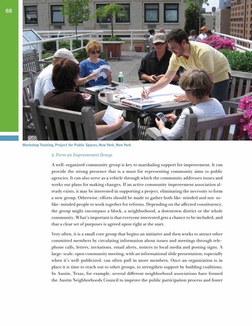
2. Form an Improvement Group
A well-organized community group is key to marshaling support for improvement. It can provide the strong presence that is a must for representing community aims to public agencies. It can also serve as a vehicle through which the community addresses issues and works out plans for making changes. If an active community improvement association al-ready exists, it may be interested in supporting a project, eliminating the necessity to form a new group. Otherwise, efforts should be made to gather both like-minded and not-so-like-minded people to work together for reforms. Depending on the affected constituency, the group might encompass a block, a neighborhood, a downtown district or the whole community. What’s important is that everyone interested gets a chance to be included, and that a clear set of purposes is agreed upon right at the start.
Very often, it is a small core group that begins an initiative and then works to attract other committed members by circulating information about issues and meetings through tele-phone calls, letters, invitations, email alerts, notices to local media and posting signs. A large-scale, open community meeting, with an informational slide presentation, especially when it’s well-publicized, can often pull in more members. Once an organization is in place it is time to reach out to other groups, to strengthen support by building coalitions. In Austin, Texas, for example, several different neighborhood associations have formed the Austin Neighborhoods Council to improve the public participation process and foster
68
workshop training, project for public spaces, new York, new York
community livability. Allies can come from chambers of commerce, schools, religious in-stitutions, advocacy organizations and corporations. This doesn’t mean that everyone will necessarily look at everything the same way. By building bridges, however, people have a better chance to overcome disagreements.
3. Talk To the People in Charge
At the outset, it’s important to start a dialogue with key people in the local planning, trans-portation, community development and transit agencies, and with others responsible for putting the needed improvements into action. This way the community can work hand-in-hand with those in charge, both to achieve goals and to draw upon the agencies’ expertise and base of information. It probably will require some re-search to find out whom to contact and how to get a working relationship started. Some sources for getting direction might be public officials who rep-resent the community, local planning boards, public interest groups and the public agen-cies themselves through their community relations representatives.
Although different agencies usually have responsibility for seeing different parts of a proj-ect through, there is usually one in particular that takes the lead, because of its involve-ment in the field most closely related to the issues of concern. One of the first questions to address is whether this agency will act as a sponsor for the desired undertaking. Another is to ascertain what other agencies would be involved along the way, from initial planning to final design specifications and construction. Potential constraints also should be explored, such as historic landmark requirements or traffic regulations that may merit negotiation. Something else that usually has to be worked out as early as possible is who will be respon-sible for maintenance of anticipated improvements. Advance contact provides the oppor-tunity to cooperate in resolving such concerns.
4. Invite a Resource Person
Whether giving a presentation or overseeing development of a vision, an expert can con-tribute valuable insights based on extensive experience. An expert can also play a sig-nificant part in providing an objective, outside point of view and bringing opposing views closer together. The expert can facilitate the planning and implementation process and stimulate new thinking. Many experts also can provide training in what comprises a good street or place, how to evaluate a particular site, and how to translate this evaluation into short- and long-term improvements. They may also be able to help you set up the struc-ture for implementation. However, don’t let the expert tell you what to do!
69
A well-organized community group is key to marshaling support for improvement.
5. Develop a Vision
Once the groundwork is laid, the community is ready to develop a vision of the place it wants to become in the future, and how this can be achieved. A vision is basically a plan for the kinds of improvements that can create such a place. In the visioning process, issues and attitudes must be clearly defined, and existing conditions studied. Appropriate strate-gies are then developed to address these community-specific concerns and serve as guide-lines for putting improvements into action. Since these strategies should be tailored to the actual needs of the particular community, it is important to be inclusive of many points of view and provide opportunities for extensive participation. To achieve optimum results, the community and the lead public agency should work together closely throughout the visioning process. The following steps are essential to conducting the process.
6. Look At What’s Going On
Clues to the kinds of improvements that are needed, as well as to where they belong, can be uncovered by watching what’s happening and where. This can be done in a systematic way by using special observation techniques to record and quantify activities and analyze pat-terns of use and conflict. For instance, such tools might pinpoint an area filled with pedes-trians that calls for seating, other amenities and additional sidewalk space. Or they might reveal pedestrian/vehicle conflicts that require a change in traffic signals or street design.
Behavior mapping is particularly effective in gathering such information. In behavior mapping, the various activities that are occurring at a site and their frequency are listed
along with the gender and age group of the people engaging in them on different days of the week (at least one weekday and one weekend day), at specific times, for given lengths of time. Careful and system-atic mapping will pick up not only who is doing what, and where, but also how many of a certain group are in an area at the same time, which can further influ-
ence the program of improvements. For example, if a group of people who appear to be in their 70s is sitting in an area, improvements could be very different from what a group of teenagers playing ball might need. Should the teens and seniors be in close proximity, im-provements might have to be devised to balance their activities or to provide opportunities for joint and mutually pleasing pursuits.
7. Ask Questions
In addition to learning what people generally do in a particular area by observing them, it is important to find out directly from individuals how they customarily use the area and how often, as well as what they think about conditions. To get this kind of information from people in the community, surveys are often used. Surveys are usually based on the issues
70
Surveys offer a chance to get input from diverse members of a community, including those who
might never attend a meeting.
that have emerged in preliminary information gathering to pinpoint issues, however, they differ considerably from the earlier informal interviews. Their questions are organized carefully and methodically, and distribution of the survey forms is typically widespread, according to a planned schedule.
Well-thought-out surveys ask not only about uses and their frequency, but also about when the uses take place and why. They also investigate people’s opinions and perceptions of an area, which are critical to know since they may differ from actual on-site findings and also from one user group to another. Surveys should invite respondents to give sugges-tions for improvements. In this way, some very creative and useful ideas may emerge that otherwise would have been overlooked.
Pedestrian, merchant and resident surveys are those most commonly used for collecting information needed to help plan community improvements. Sometimes separate surveys are required for specific user groups, like on-campus college students, who potentially may have their own unique perspective. Pedestrian surveys are conducted on the street or another public space, sometimes in the form of interviews. Merchant surveys also are de-livered in person, but usually are dropped off at the premises and picked up later. Resident surveys are either mailed from sources like government agencies, local utilities or other businesses that can reach the broad community, or they are distributed by community volunteers, with instructions to mail them back or drop them off in a designated area. Surveys offer a chance to get input from diverse members of a community, including those who might never attend a meeting. These can be conducted through schools, churches and other community institutions.
8. Get the Community Together To Talk
People also need to be given the opportunity to meet and share their improvement ideas. Small discussion groups, which concentrate on one particular topic, are one way to start eliciting opinions and ideas. The participants are usually a cross section of different citi-zens or sometimes include experts in different specialties. The groups are set up to gather opinions and perspectives through guided, though informal, conversation and interac-tion. They are valuable in providing insights into spe-cific issues that can then inform broader participatory efforts.
Broader participation occurs when all interested members of a community are given a chance to air their thoughts and suggest solutions for improve-ment. Public forums and community workshops are good for this purpose. Such meetings should be well publicized in advance, and specific materials should
71
By forming partnerships, different stakeholders can join forces to collaborate in developing improvements and to ensure that they are carried out in a timely manner.
be prepared that can clarify the issues being discussed for participants. It helps to have an outside expert facilitate the proceedings. It also is important to have the participation of public agency representatives. A good way to stimulate thinking and discussion, if pos-sible, is to present a sildeshow of existing conditions and ask someone from another com-munity that has made successful improvements to present images showing what they did. The expert might be able to help with this task. An effort also should be made to ensure that everyone gets a chance to be heard, even if some don’t speak, for instance, by distributing comment cards.
Public forums can evolve into workshop formats, that is, people break out into smaller groups that work together on the issues of concern and brainstorm ideas. If the process works effectively, working committees are formed that meet regularly to strategize im-provements and initiate action.
9. Identify Partners/Form Partnerships
Once overall goals are defined, it is time to start developing partnerships. A citizens’ advi-sory committee, for example, is a type of partnership. It is composed of community people representing a variety of interests and points of view who work with the public sector to develop recommendations and act as a sounding board concerning the public sector’s pro-posals. By forming partnerships, different stakeholders can join forces to collaborate in developing improvements and to ensure that they are carried out in a timely manner. Part-nerships provide a forum for addressing touchy issues and working out points of disagree-ment. They offer an opportunity to share diverse outlooks and bring together the expertise
of different disciplines. Moreover, their combined talents and strengths can enhance the production of effective results.
Partnerships work best with a healthy representa-tion of members from both the public and private sectors, whose roles and responsibilities are clearly defined. The successful rejuvenation of the Davis
Square neighborhood in Somerville, Massachusetts [see Chapter VI], was largely due to the cooperative efforts of a public/private partnership that included the City, local busi-nesspeople and residents, the Massachusetts Bay Transportation Authority and numerous federal and Commonwealth agencies.
10. Invite the Media
Throughout the process, in addition to announcements of meetings and presentations, newspapers, broadcast news and bloggers should be sent information about the project’s
72
Small changes can make a great difference if they have been
sensitively planned to meet ex-pressed community needs.
progress that can be turned into news coverage. Members of the press also should be invit-ed to all meetings and other events, so they are kept involved and abreast of what unfolds and can keep the public informed.
11. Create the Plan
As ideas are developed and solutions defined, there should be periodic reporting back (through meetings, forums, announcements, mailings) to the broader community for fur-ther input and, eventually, for review of final recommendations. This will lead to the es-tablishment of priorities for short- and long-term improvements, along with a timetable for their implementation and an estimated budget. At this point, program resources will have to be identified. Once the program is established and initial projects developed, im-plementation can begin.
12. Implement Improvements And Evaluate
Start Small Small changes can make a great difference if they have been sensitively planned to meet expressed community needs. It is important to get the ball rolling by implement-ing small-scale improvements that can be accomplished in a short time and that imme-diately benefit community livability. In addition, they show that positive things can be done. Sometimes citizens themselves can implement projects, such as painting benches or planting flowers. As longer-range projects are put in place, the community will already be enjoying the fruits of these initial improvements.
Evaluate Whatever changes are made, they need to be observed for their effectiveness. This can be done with the same observing, inquiring, and meeting-with-the community-techniques used in developing a vision. If feedback indicates a need for adjustment, then modifications should be made as quickly as possible. It is especially important to evaluate the initial short-term improvements, since they are usually easy to revise and can provide initial lessons about what to avoid in the longer-term projects. Ideally, evaluation should be continuous as new stages of improvement are implemented.
73
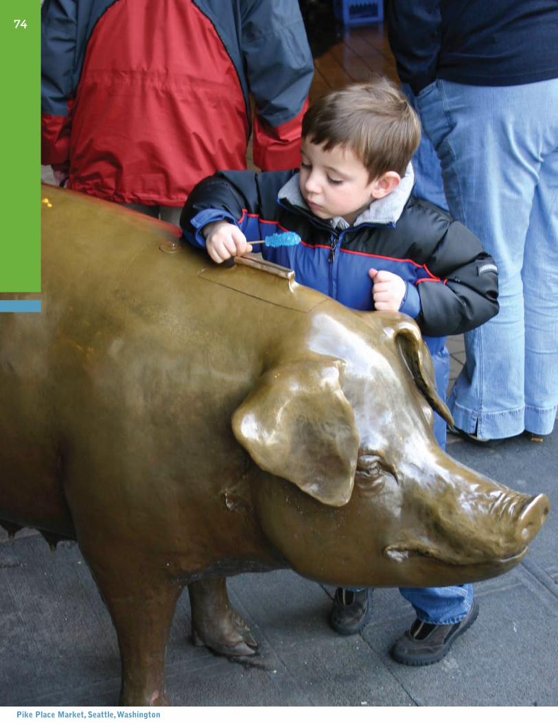
pike place market, seattle, washington
74
Finding the Money
“The buck stops here.” Harry Truman
who wIll pAY?
Less and less public money is available these days, especially for those improvements cat-egorized as ”quality of life”— that is, the ones that enhance our day-to-day experience of living in and being part of a community. It will probably take more than one source of funding to make a vision of place a reality, plus some sustained and creative digging to come up with other sources of support. In fact, many of the community achievements that have been cited on the previous pages were brought to fruition by patching together funds from a variety of public and private sources.
Dunedin, Florida’s improvements, for example, were financed by a “Penny for Pinellas” local tax, Commu-nity Development Block Grant Funds, reserve funds from the City of Dunedin’s Community Redevelopment Agency and a local gasoline tax, supplemented by City in-kind services and retailers’ own investments in upgrading their storefronts. [73] The revitalization of Davis Square in Somerville, Massachusetts was made possible with funds from the Federal Highway Administration’s Urban Systems Program, a grant from the City’s Community Development Block Grant entitlement, a local bank’s Storefront Improvement Program, Industrial Revenue (IRB) financing from the State of Massachusetts, an Urban Development Action Grant and private development money, not to mention the investment by the Massachusetts Bay Transportation Authority in con-structing the Red Line station. [49]
IX
Many community achievements were brought to fruition by patching together funds from a variety of public and private sources.
Making the Vision a Reality
These examples give some indication of the varied range of funding sources that may be necessary. What follows below are examples of other strategies communities have been using to subsidize improvements.
Local Improvement Projects in the Works and Leveraging of Funds
Scarce local funds often can be accessed by latching on to projects that are already planned. Capital improvement commitments are usually made way in advance, as are plans for re-construction or road repair, and funds are set aside for these purposes. Information on these anticipated projects is usually available from the agencies that are responsible for getting them done, such as the local Department of Transportation or Public Works. It also helps to keep an eye out for newspaper articles or notices on upcoming work. The chal-lenge is to demonstrate to the public agency how the improvements that the community wants can fit into the existing scheme or make it better. If the players involved are partners in developing a vision, this probably can be worked out in the process. If not, the commu-nity’s vision can serve to indicate how changes can be integrated. Once it’s demonstrated that some funds can be raised, other sources always seem to be more likely or willing to give. Local funds like the above, for instance, can leverage state or federal or private funds, or funding from all these sources.
ISTEA and SAFETEA-LU
The federal government took a great step toward helping local communities improve themselves in 1991 with the Intermodal Surface Transportation Efficiency Act. This fed-eral legislation, passed in 1991 and renewed in 1998 and 2005 (under the new acronym SAFETEA-LU—Safe, Accountable, Flexible, Efficient Transportation Equity Act: A Leg-acy for Users), provides for transportation funding from a new point of view that looks at transportation projects as an opportunity to improve physical, environmental, social and economic conditions in communities. SAFETEA-LU does this by allowing more flexibil-ity in allocating transportation funds generally allocated for the development of roads, so they can be used for pedestrian, bicycle, and other types of community-oriented projects. It also is designed to encourage more investment in transit, as well as public participation in the decision making process. This emphasis on communities and people also extends to support for enhancement of areas adjacent to transportation improvements, offering the potential to improve sidewalks or other public spaces, as well as to calm traffic. [51]
It was ISTEA funding that helped to implement the award-winning changes around the Woodbridge, New Jersey train station, discussed in Chapter VI. Another beneficiary of ISTEA funds was West Memphis, Arkansas and its revitalization of Broadway, the historic downtown commercial corridor that was improved with better sidewalks and crosswalks, new trees, shrubs, flowers, banners, lighting fixtures, curbs and gutters. It also received distinction as one of “America’s 25 Best Enhancement Projects.” [59]
76
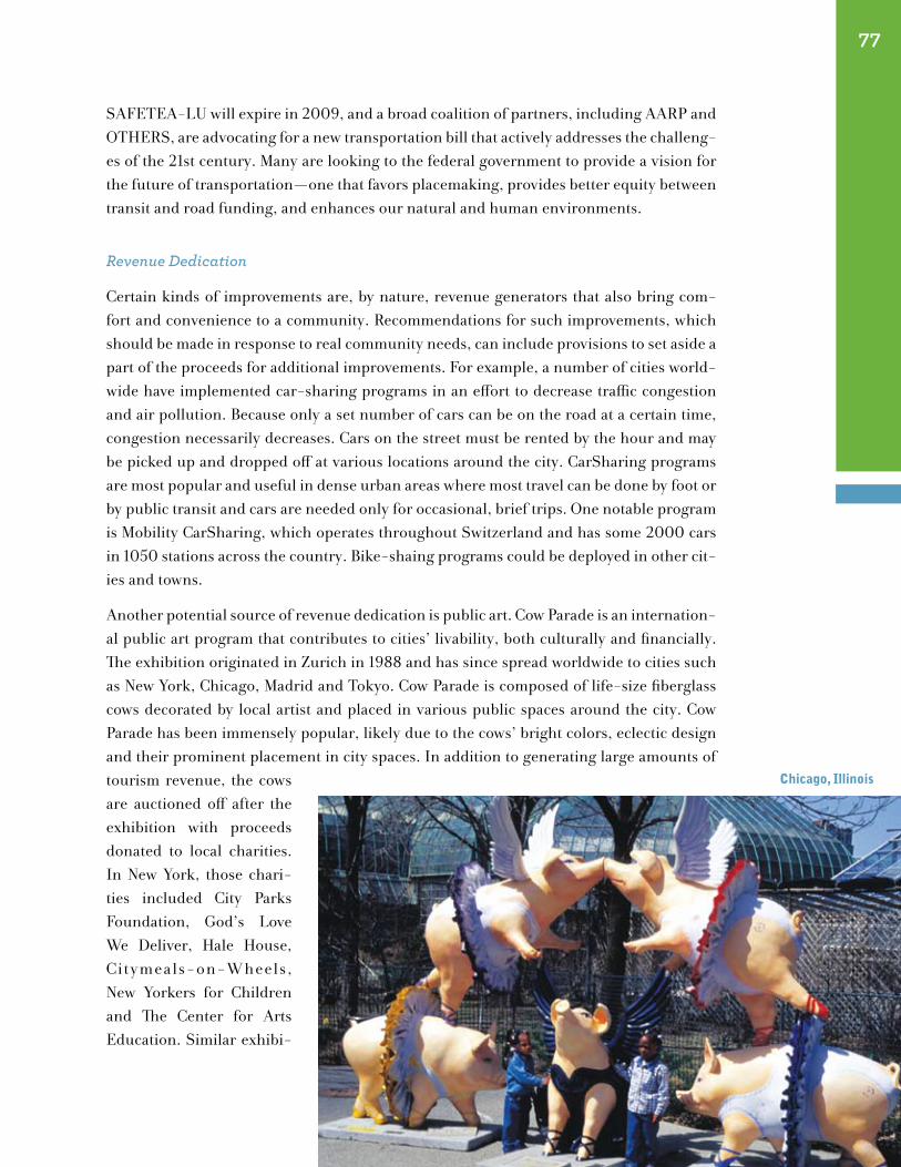
SAFETEA-LU will expire in 2009, and a broad coalition of partners, including AARP and OTHERS, are advocating for a new transportation bill that actively addresses the challeng-es of the 21st century. Many are looking to the federal government to provide a vision for the future of transportation—one that favors placemaking, provides better equity between transit and road funding, and enhances our natural and human environments.
Revenue Dedication
Certain kinds of improvements are, by nature, revenue generators that also bring com-fort and convenience to a community. Recommendations for such improvements, which should be made in response to real community needs, can include provisions to set aside a part of the proceeds for additional improvements. For example, a number of cities world-wide have implemented car-sharing programs in an effort to decrease traffic congestion and air pollution. Because only a set number of cars can be on the road at a certain time, congestion necessarily decreases. Cars on the street must be rented by the hour and may be picked up and dropped off at various locations around the city. CarSharing programs are most popular and useful in dense urban areas where most travel can be done by foot or by public transit and cars are needed only for occasional, brief trips. One notable program is Mobility CarSharing, which operates throughout Switzerland and has some 2000 cars in 1050 stations across the country. Bike-shaing programs could be deployed in other cit-ies and towns.
Another potential source of revenue dedication is public art. Cow Parade is an internation-al public art program that contributes to cities’ livability, both culturally and financially. The exhibition originated in Zurich in 1988 and has since spread worldwide to cities such as New York, Chicago, Madrid and Tokyo. Cow Parade is composed of life-size fiberglass cows decorated by local artist and placed in various public spaces around the city. Cow Parade has been immensely popular, likely due to the cows’ bright colors, eclectic design and their prominent placement in city spaces. In addition to generating large amounts of tourism revenue, the cows are auctioned off after the exhibition with proceeds donated to local charities. In New York, those chari-ties included City Parks Foundation, God’s Love We Deliver, Hale House, Citymeals-on-Wheels, New Yorkers for Children and The Center for Arts Education. Similar exhibi-
77
chicago, Illinois
tions have taken place in cities around the world with diverse themes such as “Mr. Potato Head” in Providence, Rhode Island, “GoFish!” in Erie, Pennsylvania, and “Super Lamb Banana” in Liverpool, England. [87]
Special Improvement Districts
Special Improvement Districts (SIDs) allow extra taxes to be assessed on properties within a designated district, but the revenue raised can only be spent within the area on certain kinds of projects. Setting up a district requires the affected community and local govern-ment to agree on the designated boundaries and operating rules.
The most common kind of improvement or assessment district is the BID, or Business Im-Provement District. Property or business owners in a downtown or neighborhood commer-cial district pay the supplemental property tax to add improvements to the area and consult with the government on spending decisions. Assessments are based on either square foot-age or frontage footage. Typical improvements include sanitation, maintenance, security, parking and transportation management, as well as urban design changes, streetscape en-hancements, vending programs, special events and marketing. It has been estimated that there are currently over 1,200 BIDs in the United States registered with the International Downtown Association (IDA). [52] These may vary from one place to another, since differ-ent states have different laws concerning improving districts.
Foundations and Grant Programs
Any certified non-profit organization can submit a proposal to a foundation for support of a project. Many community groups are in this category. Not every foundation, of course, funds everything, and grants are further limited by the foundation’s particular areas of in-terest and the types of initiatives that are within its scope. However, concentrated research efforts usually can turn up several possible candidates that address issues of community concern. Although there is never any guarantee, there is always a chance that one of these organizations will be able to make funds available. Local or community foundations, in particular, should be investigated becuase they are often interested in supporting under-takings that can benefit areas within their own localities. Being in the same geographic locale, these funders also may have a firsthand knowledge of conditions and an under-standing of the community’s perspective. If possible, it’s a good idea to arrange to meet foundation representatives in person once a proposal is submitted.
Special grant programs that communities can access are sometimes sponsored by state or city agencies or by quasi-governmental agencies. In Florida, for example, the Department of State has a historic preservation program which offers grants for restoring historic sites and other related improvements. New York State’s Empire Development Corporation gives a variety of economic development grants to communities, while the New York City De-partment of Cultural Affairs funds public art and other art-related projects.
78
City agencies are now also teaming up with non-profit partners, such as conservancies, that can raise supplemental funds for improvement activities. One example of this is the Riverside Park Fund (RPF), which works in coordination with the New York City Parks Department, to improve and maintain the City’s Riverside Park. The RPF not only conducts funding activities, but also coordinates volunteer efforts and has successfully rallied residents to commit their time and money to looking after individual areas in the park. Neighbors are involved in im-proving and caring for spaces that range from gardens and fountains to playgrounds and tennis courts. As a result of this program, some community groups are doing their own fundraising for specific areas. [26]
For information on foundations and other sources for funding non-profit organizations, as well as non-profit qualification requirements, the Foundation Center is a good place to begin (See “Sources and Resources,” page 91).
”Adoption” and “Own-A-Piece” Programs
Taking on responsibility for the upkeep and improvement of your own little piece of com-munity can be a gratifying, heady and even empowering experience. This may explain why adoption programs are becoming more and more popular throughout the country. The way they work is a certain public facility or space or piece of public art that needs nurturing is put up for adoption by the “parent” city or state. The adopter can be an individual or a group or a business entity. What’s important is a willingness to commit to the loving care of the adopted “child.” This care can be in the form of donated money to a “guardian” who does the nurturing (the public agency in charge) or donated time by the “adoptive parent” who does his or her own tending —or both!
Riverside Park, discussed above, host to some 40 areas that are planted, maintained and cleaned by community people, clearly benefits from active stewards although it doesn’t have a formal adoption program. Adopt-A-Station, another New York City program, run by the Metropoli-tan Transportation Authority, is named for what it does, which, in this case, is to arrange for corporate donors to adopt particular subway stations and fund their improvement. The Adopt-A-Station program sponsored by the State of Virginia Railway Express requires the adopting organizations or individuals to take part in maintaining railroad stops by sweeping or picking up trash or arranges for a “Landscape Adoption” to plant flowers, weed and fertilize. Signs are posted at the stations to indicate the name of the adoptive caregivers. Similarly, the Adopt-A-Stop program in Savannah, Georgia invites residents living near a Chatham Area Transit sys-tem bus stop and shelter to adopt the site and make a commitment to keep it litter-free. Some “adoptive parents” also landscape these areas.
In a similar vein, the Chicago Transit Authority (CTA) offers an Adopt-A-Station program, al-lowing organizations to take responsibility for a piece of their community by making their local transit station a unique and inviting attraction. Organizations do not pay a fee to participate,
79

but are instead responsible for conceiving of a plan for the station and to cover all costs and materials associated with the adoption. Adopting organizations commission public art-ists to create murals, mosaics and other works of art that reflect the culture of the local community, thereby providing a connection between the station, the organization and the community. The adopted stations are welcoming places and attract more transit riders than ordinary stations. The program began in 1997 and station adoptions last for two years. In 2005, 20 stations were under adoption.
New York City is also home to Adopt-A-Mural and Adopt-A-Monument programs, which are run by the Municipal Art Society, a non-profit organiza-tion that works to improve the city’s built environment. These two programs were conceived by the Society, in conjunc-tion with the New York City Art Commission, to rescue public art from deterioration through privately funded restoration projects. Working with the city’s Art Commission and Depart-ment of Parks and Recreation, the Society selects significant public monuments and murals that have “fallen on hard times” as candidates for adoption. The Society then conducts outreach to secure private sponsors and issues requests for proposals to conservators through the city agencies that have the specific artworks in their domains. Adopters include corpora-tions, small foundations and individuals who have contributed a total of over $2 million leading to the restoration of 15 murals and 38 monuments. Similar programs operate in Boston, Chicago, Dallas, Montreal, San Francisco and Toronto. [28]
The Central Park Conservancy offers a similar adoption program using benches rather than monuments. For $7,500, individuals can Adopt-a-Bench that bears an engraved plaque with the inscription of their choice. The Conservancy then maintains the bench indefinite-ly. Since the program’s inception in 1986, about 2,000 of Central Park’s 9,000 benches have been adopted. This program aims to create a permanent fund for the maintenance of all of Central Park’s benches and also provides a way for individuals to have a personal
80
grand Army plaza, Brooklyn, new York
connection with the park. Bench inscriptions range from traditional memorials to mar-riage proposals to personal quotations and can be placed on a variety of different bench types, allowing for maximum personalization as well as increased diversity of park ameni-ties. The Adopt-A-Bench program is a perfect example of the way community members can gain responsibility for a small piece of their community. [88]
Closely related to adoption programs are initiatives that have raised improvement funds by actually selling pieces of the project area to members of the community. The pieces are usually small elements, like tiles or bricks that become both practical and decorative parts of the improved area, as well as symbols of community involvement. When funds were needed to supplement government support to construct Portland, Oregon’s Pioneer Courthouse Square (see Chapters IV and VII), more than $1.7 million was raised through the sale of 71,165 paving bricks, each imprinted with its sponsor’s name. Another $1 mil-lion was generated by the sale of design elements, from the amphitheater to drinking fountains. Both initiatives raised money and created a loyal constituency for the Square. “Owners” continue to come to the Square to admire their “holdings.” [49]
Yet another group of citizens, in Seattle, Washington, contributed to the revitalization of their city’s historic Pike Place Market when they bought personalized tiles that were used to pave the floor of the Market Arcade. An additional fund-raising phenomenon at Pike Place is the giant piggy bank in the Market that pulls in some $14,000 a year in donated coins. [23]
The success of the above ventures provides an optimistic glimpse at the types of alterna-tive approaches that currently help to bring in money or in-kind support that at least can supplement, if not replace, traditional government funding for improvements. Of course, the above approaches are, by no means, the only ways to muster support. Rather they rep-resent a sampling of some possibilities, with the hope that they may inspire some further exploration as well as invention.
81
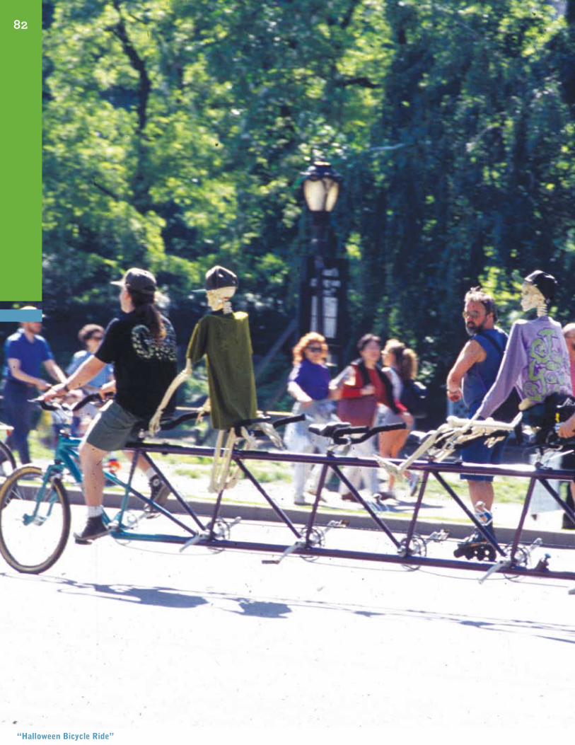
82
“halloween Bicycle ride”
As the Journey Begins...Success Stories
“The journey of 1,000 miles begins with the first step.” Chinese proverb
So, it can be done! It is still possible to preserve, create, revitalize, or retool our com-munities to regain their human-scale, people-oriented, familiar, easy-to-walk-around, pleasant feeling that seems to be rapidly disappearing from the American landscape. Make no mistake that most of what’s out there can be discouraging—the vast sprawl and the vast distances to get from here to there, the impersonal, empty-feeling strip developments along the way, the dearth of places to sit or walk and stop for an informal chat. However, as we’ve also seen, there are cities and towns where people are beginning to boost their com-munities with viable, walkable places, where they can both live and do business, without being overrun by traffic.
There is no doubt that people are becoming aware of what they’re missing. Witness the case of Schaumburg, Illinois, where a town center is being built where there never was one before, just because its suburban residents want a place where they can interact as a community. This is happening in many other outlying suburbs around the country. [22] And, there are still many older communities with the basic underpinnings of a pedestrian-friendly environment that can be restored with lively, people-scale places by using some conscientious reconditioning.
The movement has already begun. A rediscovered ethos is emerging that looks at trans-portation and community planning as a balancing act in which streets and public spaces are the settings for a great variety of community activities. It recognizes that these activi-ties must take place in an environment that comfortably meets the needs of people, not
X
just vehicles. This ethos is already beginning to be put into practice as standard policy in certain cities, as seen in their innovative and promising planning guidelines.
sAn frAncIsco, cAlIfornIA
In June of 2008, San Francisco drafted a plan which, in the words of Mayor Gavin News-om, aims to “improve San Francisco’s streetscapes—to make our streets more useable and attractive and universally accessible to all” [89]. The Plan acknowledges and aims to spread the notion that streets are used for more than merely transportation. Particularly in a city like San Francisco, where 20 percent of all trips are made on foot, streets are vital areas of urban social life. The Plan offers a vision and design guidelines for a pedestrian realm that fosters public life, is attractive, safe, accessible and ecologically sustainable. The design guidelines include standard, simple, low-cost improvements such as the addition of trees,
curb ramps and street furniture, as well as case-specific solutions such as mid-block crosswalks and landscaped medians. The guidelines also provide explanations and diagrams for how to improve existing features of streets such as crosswalks and bus shelters, how to better in-tegrate pedestrians and transit by implementing traffic calming measures, and streetscape improvements in-
cluding paving, street furnishings and stormwater control measures. This comprehensive plan will ensure the creation of efficient and pleasant streets for all of San Fransisco. [89]
new JerseY And pennsYlVAnIA
Although improving pedestrian areas of streets is an essential element of Placemaking, it is impossible to ignore streets’ more dominant feature: the roadway itself. The New Jersey and Pennsylvania State Departments of Transportation (DOTs) have introduced a principle called “Smart Transportation,” which aims to better integrate roadways into the surround-ing landscape by designing roads and highways that respond to the context of commu-nities. The new Smart Transportation Guidebook outlines different community contexts (including rural, suburban neighborhood, suburban center and urban core) and different roadway types based on desired speed, trip length, and traffic volume (types include com-munity arterial, neighborhood collector and local road) and guidelines for designing roads that best integrate the two categories.
One of the main concepts of Smart Transportation is vehicle speed, and the way it is influ-enced by road design features. Lower speeds are associated with such features as on-street parking, narrower road widths and pedestrian amenities. Smart Transportation advocates designing roads for speeds appropriate to their contexts. If roads are designed to discour-age speeding, they will be more safely used by pedestrians, bicycles and other modes of transportation. Through collaboration with the local community and local planners, the
84
The movement toward creating people-scaled
places has already begun.
DOT, using Smart Transportation guidelines, can make streets more walkable and more comfortable for community use and street life on roadways that do not serve statewide mobility needs (e.g., not on freeways). The Smart Transportation approach recommends building wider sidewalks, better mid-block crossings and sidewalk buffers in urban and suburban areas to better integrate pedestrian and roadway spaces. It also recommends better use of public transportation to create an environment that is functional for motor vehicles and operates as a true place. [90]
AtlAntA, georgIA
In downtown Atlanta, Georgia, the Atlantic Station Access & Mobility Program (ASAP+), developed in early 2006, provides transportation information, incentives and services to people who use the new Atlantic Station mixed-use development. Atlantic Station, a 24-hour community, is home to 10,000 people, employs another 30,000 and provides shopping and entertainment for many more. The ASAP+ program informs commuters about smart and sustainable alternative transportation strategies to encourage a healthy and cost-effective lifestyle and to develop pedestrian-friendly streets with fewer cars and more opportunities for vibrant public life.
ASAP+ consists of a number of programs, such as Cash for Commuters, which provides monetary incentives for individuals who carpool, work from home, use mass transit, walk or bicycle to work instead of driving alone. The Carpool Rewards program provides monthly gas cards of $40 to $60 for carpools of three or four people. ASAP+ also provides a free shuttle from Atlantic Station to the nearest rapid transit stop. [91]
new York, new York
The New York City Streets Renaissance program was launched in 2005 by The Open Plan-ning Project, Transportation Alternatives and Project for Public Spaces, to help New York-ers reimagine their streets as healthy centers of public life. It emphasizes pedestrians and community over vehicles and traffic, and educates about the possibilities of transportation policy change that could turn New York City streets from corridors for cars into lively civic spaces.
The Streets Renaissance program developed concepts for several demonstration projects in some of New York’s most car-dominated areas, such as Times Square, Hell’s Kitchen and Grand Army Plaza in an effort to make New Yorkers aware of the potential of their streets and of ways to realize that potential. One successful Streets Renaissance project is Gansevoort Plaza in the Meatpacking District. This intersection of five streets was once a dangerous and confusing spot plagued by traffic congestion, but now with a few simple changes such as the addition of bollards that double as seats, traffic has been slowed and Gansevoort Plaza is a lively and comfortable pedestrian area. [92]
85
hAnd In hAnd
As more and more community-building initiatives begin to pave the way, the future looks promising for the rediscovery and application of how to slow down traffic and create places that sustain a strong sense of community. As we embark on the journey to bring back a more balanced, people-scaled approach to building our communities, we must keep re-minding ourselves that making places livable involves many different elements and finding workable ways of fitting them together. It is never just traffic, just design, just amenities, just activities, just buildings, just facilities, just services that make all the difference, but how a place is experienced holistically. Elements, of course, are not all that have to work hand in hand. It is even more important that people do the same.
86

APPENDICES
87

How to Organize and Facilitate a Community MeetingInVIte people to the meetIng
• Makealistofallthecitizens,organizations,cityofficials,merchantsandbusinesses,andclubsthat could participate in or would be affected by the project being discussed at the meeting. include their addresses and telephone numbers.
• Chooseadayandtimeforthemeeting.Timeswillvaryfordifferentcommunities.Earlyeve-
nings are often the best time: 6:00 or 6:30 p.m. after dinner (7:30 p.m.) is good if the meeting will take place in the neighborhood where most of the people live. also, mid-week (Monday through thursday) is usually better than weekends or fridays.
• Choosea location for themeeting.Theplaceshouldbecentrally locatedandconvenient for
people to get to and be large enough to accommodate a large group. a school, a library and city Hall are popular locations.
• Writeaninvitationdescribingtheday,timeandlocationofthemeetingandabriefstatement
about the meeting’s purpose—what the meeting is about, why it is being arranged and what you hope will be accomplished. include a phone number and email address and ask the recipients to rSVP so you know how many people will be attending.
• Callallofthepeopleonyourlistoneweekbeforethemeetingtomakesurethattheyplanto
attend.
settIng up the room
• Itisimportantthattheroombesmallenoughsothatspeakerscanbeheardbyeveryone,butlarge enough to accommodate 50 to 100 people. there can be a podium at the front of the room for the speakers to use. the audience should be seated in chairs in a semicircle facing the speak-ers. if there is not enough space, chairs can be arranged in rows for the beginning and end of the meeting.
• Ifaslideshowisgoingtobeshown,itshouldbepossibletomaketheroomdark.
• Theroomshouldbelargeenoughthat,afterthemainpresentation,peoplecanmovetotheirsmall discussion groups. People should be able to easily move their chairs to other parts of the room, or there should be other, smaller rooms available for people to move to.
tools And personnel
there should be one primary facilitator for the whole group, and a facilitator and recording secre-tary for each of the smaller groups. Groups can select their own recorder to write down ideas from their discussion, or the facilitator can perform this task.
89
You will need to have the following materials at your meeting:
1. flipcharts of large paper for writing down issues and ideas. You will need enough paper for each small discussion group.
2. easels to hold the large pieces of writing paper. if you do not have enough easels for each group, you can hang the paper on the wall with tape or pins.
3. large felt marking pens, so the facilitator can write large enough for everyone to read.
4. a sign-in sheet should be provided at the front door, so everyone who comes to the meeting can write down his or her name, address, email, and phone number, so you can contact them again and invite them to the next meeting.
5. Have name tags for all the participants and facilitators.
6. Provide an agenda. this is the schedule of the evening’s program, including topics for discussion, names of the speakers and the order in which the meeting will progress. these should be handed out to everyone as they come in.
7. to organize people for the small group discussions, you will have to assign them to a group. it is important that the discussion groups have a diverse combination of people in them, rather than everyone from the same firm or family. if you expect 100 people, you would separate them into 10 groups with 10 people in each for the small group discussion. cut 100 pieces of paper into small squares, and make 10 sets numbered from one to ten. Give each person a number in se-quence as they come through the door.
8. if a slideshow is going to be shown, you will need a laptop, a projector, the right cords to connect the two, a screen or blank wall to project onto and an extension cord. remember to test all equp-ment before the meeting!
9. refreshments (optional).
meetIng procedures
1. before the meeting, as people come in the door, they will sign in, pick up a meeting agenda and be given a name tag and a number for the small discussion group.
2. because some people will come late and others will leave early, it is important to start the meet-ing on time.
3. the facilitator should welcome everyone to the meeting, introduce the other speakers, and de-scribe the schedule for the evening’s meeting.
4. a slideshow presentation describing the project and project area, problems, issues and solutions from other cities could be shown. it should last no longer than 15 or 20 minutes.
5. break down into small groups for discussion. following the presentation, the facilitator describes the topics that each of the small groups is being asked to discuss and calls the small groups to-gether, telling all of the people with the number “1” to bring their chairs to one part of the room, the number “2” to another part of the room, and so on.
90

6. each small group engages in discussion of the topic for a specified period of time, usually 20 to 30 minutes. the discussion should encourage the free exchange of ideas and solutions, rather than serve as a session for complaining. Solutions should focus on short-term, small-scale ideas and projects. everyone’s ideas should be written down, without judgment, and the facilitator should encourage everyone to speak.
7. one person from each small group is selected to report back to the whole group. reporting back to the whole assembly endorses and lends support to the ideas generated by each group and each individual at the meeting. Group 1 would read aloud to the whole group the ideas and solutions which it generated during its discussion, then Group 2, Group 3, etc., until all of the groups have reported. this can take a long time, but each group should be given at least five minutes to make their presentation.
8. When everyone has reported back, the primary facilitator should make concluding remarks that should describe the specific next steps to be taken, ask for volunteers interested in helping with some aspect of the project, and thank everyone for coming. a social gathering afterwards is often nice and provides a way for the discussion to continue informally.
helpful hInts
1. if there are disruptive or angry people at the meeting, they should be allowed to speak, but at the very end of the meeting after all presentations and small group discussions are finished.
2. Keep the discussion positive—concentrate on developing creative ideas and solutions instead of complaints and criticism.
3. Help people to participate in the discussion. call them by name, ask them specifically for their thoughts and ideas.
4. encourage and compliment your group on the number and quality of their ideas.
5. facilitators should remain neutral. they should not evaluate ideas or offer their own.
6. the meeting should move at an appropriate pace so that it ends at a reasonable time. facillitators should keep the meeting moving along, and make sure particpants know the expected length of each part of the meeting.
91
Glossary
trAnsportAtIon specIfIc terms
Arterial: A highway that provides direct service between cities and towns, generally ac-commodating long distance travel at relatively high speeds. Arterials can be freeways or land service highways, and they prioritize mobility over access to land uses.
Average Delay: The total delay experienced by all vehicles divided by the number of vehicles.
Average Speed: The sum of each vehicle’s speed divided by the number of vehicles.
Boulevard: A wide, urban street lined with trees, usually with a median or promenade. Boulevards often have side access roads with parking and building access.
Bulbout: An extension of the sidewalk or curb line into the parking lane to reduce the effective street width, either at an intersection or mid-block. Also known as bumpouts, neckdowns or curb extensions, bulbouts significantly improve pedestrian crossings by reducing the pedestrian crossing distance and the time that pedestrians are in the street, and by slowing turning vehicles by reducing the corner radii. Curb extensions are only appropriate where there is an on-street parking lane or bus pullouts. They provide addi-tional sidewalk space for street activity, landscaping and street amenities such as bicycle parking, bus shelters, and seating.
Chicanes: A series of curb extensions on alternating sides of the street that effectively introduce curves into a roadway that breaks up sightlines and slows traffic. Chicanes can also be formed with sculptures, plantings or parking.
Clear Zone: The unobstructed, relatively flat area provided beyond the edge of the trav-eled roadway for the recovery of errant vehicles, including shoulders or auxiliary lanes.
Collector: Connects neighborhoods and local streets to arterial roadways. These facilities balance mobility and land access and often penetrate into developed areas, including res-idential neighborhoods, commercial and industrial areas, and central business districts.
Corner Radii: The radius of an intersection corner determines the sharpness of the turn. There is a direct relationship between the size of the curb radius and the speed of turning motor vehicles. Reducing a corner radius adds sidewalk space and improves pedestrian safety by decreasing turning speeds and the pedestrian crossing distance.
Corridor: A geographic area that accommodates travel, generally in a linear pattern. A corridor connects activity centers with a single or multiple transportation routes and facilities. It also includes adjacent land uses and the connecting street network.
92
Curb Cut: A curb cut is an inclined cut in the edge of a sidewalk to permit vehicular access to a driveway, garage, parking lot or loading dock. Curb cuts also accommodate wheelchairs and strollers at intersections.
Cycle: A complete sequence of traffic signal indications; all directions of turning and through traffic have been allowed to pass through the intersection.
Cycle failure: When a vehicle must wait for more than one cycle to travel through a sig-nalized intersection.
Design speed: The selected speed used to determine the various geometric features of a roadway, such as curvature, sight distance and lane width. It should fit the travel desires and habits of nearly all drivers expected to use a particular facility. The assumed design speed should be logical with respect to topography, adjacent land uses, and functional classification.
Diverters: Traffic diverters are physical barriers that redirect traffic heading for a particu-lar street onto a different course. They are often used to reduce vehicle traffic on vulner-able residential streets. Diverters can also restrict right- or left-hand motor vehicle turns into or out of an intersecting street or private drive. In all cases, paths, cut-throughs, or other provisions should be made to allow bicycle and pedestrian access across the clo-sure.
Functional Classification: Groups roadways by the character of service they are intended to provide. Arterials, collectors and local streets are the primary classifications.
Grade: Rise in elevation within a specified distance.
Grade Crossing: A crossing or intersection of highways, railroad tracks, other guideways, or pedestrian walks, or combinations of these at the same level or grade.
Grade-Separated: A vertical separation of intersecting facilities (highway, railroad, etc.) by the provision of crossing structures at different elevations.
Intermodal: Allows convenient transfers between means, or “modes,” of transportation. Potential modes include vehicles, pedestrians, bicyclists, trains, boats and aircraft.
Level of Service (LOS): A qualitative rating of the effectiveness of a highway facility in serving traffic, in terms of operating conditions (speed, travel time, comfort, conve-nience, traffic interruptions, freedom to maneuver). The Highway Capacity Manual iden-tifies operating conditions ranging from A, for best operations (low volume, high speed) to F, for worst conditions (congestion, delays). LOS can also be used to describe transit and bicycle/pedestrian networks.
Local Street: Provides direct access to individual residences or other local destinations.
Median: A raised barrier used to separate opposing traffic flows and control access and turning movements. A median can also serve as a pedestrian crossing refuge and a streetscape enhancement.
93
Multimodal: A system or corridor providing a range of transportation options including walking, bicycling, driving, and transit.
Multi-Use Path: A bikeway physically separated from motorized vehicular traffic by an open space or barrier located either within the highway right-of-way or within an inde-pendent right-of-way. Shared use paths may also be used by other non-motorized users.
Pavers: A traffic calming solution in which the street or sidewalk is distinguished by color or texture to attract visual attention and slow traffic. Pedestrian crosswalks are a common use for this treatment.
Right-of-Way (ROW): Publicly-owned land in which streets, sidewalks, alleys, transit and railroad lines, and public utilities are located.
Roundabouts: A traffic calming intersection treatment in which vehicles follow a circular path around a central island; upon approaching the roundabout, vehicles are expected to yield to traffic already in the circle.
Rumble Strips: Textured pavement treatments that calm or slow traffic.
Street Furniture: Fixtures installed along the roadway, at or above grade level, includ-ing lamp posts, pedestrian lighting, fire hydrants, street signs, benches, trash cans, bike racks, newspaper boxes, water fountains, and planters.
Traffic Calming: Transportation techniques, facilities, or programs designed to slow the movement of motor vehicles. Traffic calming typically involves changes in street align-ment, installation of barriers and other physical measures to reduce traffic speeds and/or cut-through volumes in the interest of safety, livability, and other public interests. Physical treatments may include speed tables, raised crosswalks, textured pavement, roundabouts, chicanes, curb extensions, partial roadway closures, diagonal diverters and median barriers.
Traffic Circle: An intersection treatment with a circular shape and, usually, a central island. In some traffic circles two-way traffic is allowed within the circle. It is much more common, however, that traffic is allowed to go in one direction only around a central island. Traditionally, traffic entering a circle has the right-of-way, although some circles give right-of-way to the primary roads; this is the primary difference between traffic circles and roundabouts. Other differences may include size, entry treatment, and design speed.
Transportation Forecasting: The process of estimating the number of vehicles or travel-ers that will use a specific transportation facility in the future. A traffic model generates the future output and demand for a specific roadway, transit station or transit route by considering population and employment trends, VMT growth, trip generation rates for new development, travel costs, capacity and more.
Transit Oriented Development (TOD): High-density development within walking distance of a transit stop or station that mixes uses such as residential, retail, office, open space, and public facilities in a way that makes it convenient to travel on foot or by public transportation instead of by car.
94
Vehicle-Miles Traveled (VMT): The total number of vehicle miles traveled within a specific geographic area over a given period of time.
Volume/Capacity (V/C) Ratio: A measurement of roadway travel performance. It is calculated by dividing the number of vehicles passing a designated spot during a specified time interval by the theoretical capac-ity of a transportation facility. The capacity is the maximum rate of flow of the roadway under ideal condi-tions. The V/C ratio is typically measured during peak travel periods.
AgencIes And orgAnIZAtIons
Department of Transportation (DOT): State or city agency that is responsible for the construction and maintenance of their jurisdiction’s transportation infrastructure, often including roadways, sidewalks and bicycle paths. In many places, a Department of Roads or Public Works fulfills this role. Transit service and facilities are usually the jurisdiction of separate agencies.
Metropolitan Planning Organization (MPO): Federally mandated regional organizations responsible for comprehensive transportation planning and programming.
Federal Highway Administration (FHWA): Within the US Department of Transportation, FHWA is re-sponsible for highway issues, including federal laws and regulations related to metropolitan transportation planning.
American Association of State Highway and Transportation Officials (AASHTO): A nonprofit, nonpar-tisan association representing highway and transportation departments in the 50 states, the District of Columbia, and Puerto Rico. Its primary goal is to foster the development, operation, and maintenance of an integrated national transportation system.
Business Improvement Districts (BIDs): A Business Improvement District is a formal organization made up of property owners and commercial tenants who are dedicated to promoting business development and improving a commercial area’s image. BIDs deliver supplemental services such as sanitation and main-tenance, public safety and visitor services, marketing and promotional programs, capital improvements, and beautification - all funded by a special assessment paid by property owners within the district. BIDs are also known in some areas as business improvement areas, business revitalization zones, community improvement districts, or special service areas.
generAl plAnnIng terms
As-of-Right: As-of-right development complies with all applicable zoning regulations and does not re-quire any discretionary action by the local City Planning Commission or other advisory agency.
BANANA: An acronym for “Build Absolutely Nothing Anywhere Near Anything (or Anyone).” The term is most often used to criticize the ongoing opposition of certain interest groups to every instance of proposed development.
Directional Signage: Signs with text and/or images that direct pedestrians, bicyclists, motorists, and tran-sit riders to and around a destination.
95
Floor Area Ratio (FAR): Total building square footage (building floor area) divided by the square footage of the zoning lot (site area), or the limit imposed on such a ratio. FAR is the principal regulation controlling the size and bulk of buildings. Also known as Floor Space Index.
Land Use: The way in which a parcel of land is used or occupied, which includes the types of buildings or activities and/or the purpose for which it is designed, arranged, intended, or maintained. Common categories of use are residential, commercial, mixed-use, in-dustrial, parks and open space, institutional and transportation-related.
LULU: An acronym for a “Locally Unwanted Land Use,” such as a power plant, prison, landfill or major arterial highway.
Human Scale: An emphasis on building features and characteristics which can be ob-served in close proximity, at the speed a pedestrian would travel; also describes an area in which pedestrians can comfortably walk from one location to another.
Master Plan / Comprehensive Plan: A long-term planning document that is comprehen-sive in its approach and breadth. All land uses including, but not limited to, residential, commercial and open space are analyzed.
Mixed-Use: Mixed-use development is designed to encourage a variety of community ac-tivities and residential, office and commercial uses to co-exist in close proximity. A mixed use district is a special zoning district in which new residential and non-residential uses (commercial, community facilities and light industrial) are permitted as-of-right.
NIMBY: An acronym for “Not In My Back Yard.” The term is used to describe opposition to construction of a new public facility by residents, even if they themselves and those around them will benefit from its construction.
Pedestrian-Scale Lighting: Improves walkway illumination for pedestrian traffic, en-hancing comfort and safety. Pedestrian lighting is oriented to the sidewalk rather than the taller highway-style “cobra” light fixtures.
Setback: The distance between a building and the property or right-of-way line, or the limit imposed on such a measurement in zoning regulations.
Wayfinding: Wayfinding encompasses all of the ways in which people orient themselves in physical space and navigate from place to place. In the Image of the City by Kevin Lynch, wayfinding is defined as “a consistent use and organization of definite sensory cues from the external environment.” Often relates to signage.
Zoning: Regulates the use, bulk and density of land use development. A zoning district is a mapped district with similar characteristics. Downzoning reduces the density or FAR of an area, while upzoning increases the FAR.
96
sources
• American Association of State Highway and Transportation Officials. A Policy on Geometric Design of Highways and Streets, 5th Edition. 2004.
• http://www.teachmefinance.com/Scientific_Terms/Vehicle_Miles_Travelled_VMT.html• http://en.wikipedia.org/wiki/NIMBY• http://en.wikipedia.org/wiki/BANANA• West Virginia Division of Highways. Corridor H, www.wvcorridorh.com/resource/terms.html• Municipality of Anchorage, Alaska, Traffic Department, http://www.muni.org/transplan/glossary.cfm• Safe Routes to School, http://www.saferoutesinfo.org/guide• Federal Highway Administration, http://safety.fhwa.dot.gov• Lake County, Illinois, http://www.lakecountytip.com/• Great Streets St. Louis, http://www.greatstreetsstlouis.net
97

Photos and Illustrations: credIts, sources And InformAtIon
All photos copyright PPS except for the following:
Chapter II
Page 8. Meriden, Connecticut: The Way It Was. Photos: Courtesy, Meriden Historical Society, Inc.
Chapter III
Page 14. Oberlin, Ohio: Diagonal Parking. Photo: Hutton & Associates
Page 17. Drawing: Patrick Doran
Page 19. Metchuen, New Jersey Photo: www.city-data.com
Page 20. West Chester, Pennsylvania. Photo: Courtesy, Borough of West Chester, Pennsylvania
Chapter IV
Page 22. Campus Martius Park, Detroit Michigan. Photo: Robert F. Gregory
Chapter V
Page 37. Maine Street, Cambridge, MA. Photo: Dan Burden
Chapter VI
Page 48. Staples Street Bus Transfer Station, Corpus Christi, Texas. Photo: Steve Ortmann
Page 49. Ronstadt Transit Center, Tucson, Arizona: Downtown Saturday Night. Photo: Balfour Walker
98
Sources and ResourcesPublications, Papers, Plans, Presentations
1. Abbott, Carl. Portland: Planning, Politics and Growth in a Twentieth Century City. Lincoln, University of Nebraska Press. 1983.
2. Anders Nyvig A/S and Working Group. “Geometrical design of individual elements of urban traffic net-works.” Urban Traffic Areas (Road Standards). Denmark, Danish Road Directorate, Ministry of Trans-port. 1991-1993.
3. Anderson, Peter; Borges, Per; Herrstedt, Lene et al. An Improved Traffic Environment—A Catalogue of Ideas. Denmark, Danish Road Directorate, Ministry of Transport. 1993.
4. Berendt, John. Midnight in the Garden of Good and Evil. New York, Random House. 1994.
5. Burrington, Stephen H. and Thiebach, Veronica. Take Back Your Streets: How To Protect Communities from Asphalt and Traffic. Boston, Conservation Law Foundation, 1995.
6. Cambridge Systematics and Project for Public Spaces, Inc. Downtown Boston Transportation Plan. 1995.
7. CART (Citizens Advocating Responsible Transportation). Traffic Calming: The Solution to Urban Traffic and a New Vision for Neighborhood Livability. Ashgrove, Australia, CART. 1989.
7a. Cheslow, Jerry. “If You’re Thinking of Living in Metuchen, N.J. Battling to Retain Its Small-Town Iden-tity.” The New York Times. April 21, 1996.
8. City of Seattle. Making Streets That Work: Neighborhood Planning Tool. Seattle, Washington, City of Seattle. 1996.
9. Clarke, Andrew and Dornfield, Michael J. National Bicycling and Walking Study, Case Study No. 19: Traf-fic Calming, Auto Restricted Zones and Other Traffic Management Techniques–Their Effects on Bicycling and Pedestrians.
10. Conservation Law Foundation of New England, Inc. The Automobile Index. 1990.
11. Convissor, Dan and Orcutt, John. “The Auto-Free Washington Square Park Movement: 1952-58.” Auto-Free Press. November/December 1991.
12. Corbett, Judith. ”Portland’s Livable Downtown: From Auto-Dependence toPedestrian Independence.” Surface Transportation Policy Project Resource Guide. Washington, DC, STPP. 1992.
13. ”Court Street Square–A New Heart for Downtown.” Main Street (San Bernardino, California). Spring 1994.
14. Davies, Stephen and Secunda, Shirley. “A New Angle on Revitalizing Downtowns.” Center City Report. Fall 1993.
99
15. Davies, Stephen and Secunda, Shirley. “Edge Cities Offer Lessons on Revitalizing Downtowns.” The Planning Report. April 1994.
16. Devon County Council Engineering and Planning Department. Traffic Calming Guidelines. Devon County, England, Devon County Council. 1991
17. Engwicht, David. Reclaiming Our Cities and Towns: Better Living with Less Traffic. Philadelphia, New Society Publishers. 1993.
18. Fernandez, John M. “Boulder Brings Back the Neighborhood Street.” Planning. June 1994.
19. Gratz, Roberta. The Living City: How America’s Cities are being Revitalized by Thinking Small in a Big Way. Washington, DC, The Preservation Press. 1994.
20. Horowitz, Josh. “Retirees Seen as Benefit to Main Street Development.” Main Street New York. January 1992.
21. Jacobs, Jane. The Death and Life of Great American Cities. New York, Random House. 1961.
22. Johnson, Dirk. “Schaumburg Journal: Town Sired by Malls Creates Downtown.” The New York Times. August 7, 1996.
23. Koenig, Sarah. “Calming Traffic’s Mad Waves.” The East Hampton Star. May 20, 1993.
24. Kunstler, James. The Geography of Nowhere. New York, Simon & Schuster. 1993.
25. Latham, Aaron. “Santa Monica’s Urban Living Room.” The New York Times. January 5, 1992.
26. Lila Wallace. Reader’s Digest Fund Urban Parks Institute. Riverside Park and the Riverside Park Fund: A Partnership Encourages Community Participation. New York, 1996.
27. Moudon, Anne Vernez. Public Streets for Public Use. New York, ColumbiaUniversity Press. 1987.
28. Municipal Art Society of New York. Annual Report 1992-1994. New York, 1994.
29. Nieves, Evelyn. “A Radar Gun Is a Fast Track to Celebrity.” The New York Times. July 31, 1996.
30. Oliver, Gordon. “Portland Revs Up for Action.” Planning. August 1994.
31. Olszewski, Laurie. “Concrete Action to Stop Speeders.” San Francisco Chronicle. March 24, 1993.
32. Ortega, Bob. “Portland, Ore. Shows Nation’s City Planners How to Guide Growth.” Wall Street Journal. December 11, 1995.
33. Pedestrian Federation of America. Walk Tall: A Citizen’s Guide to Walkable Communities. Emmaus, Pennsylvania, Rodale Press. 1995.
34. Pioneer Courthouse Square. “July Events on the Square.” News! July 1993.
35. Planning Department, City and County of San Francisco. Destination Downtown: Streetscape Invest-ments for a Walkable City. San Francisco, California, City of San Francisco. July 13, 1995.
100
36. Portland Comprehensive Transportation Plan Advisory Committee. A Time of Change: Portland Trans-portation Plan. Portland, Maine, City of Portland. January 1993.
37. Pringle, Kenneth, Mayor, Borough of Belmar, New Jersey. Presentation: “Creating Pedestrian Environ-ments.” Downtown New Jersey Conference. June 14, 1996.
38. Project for Public Spaces, Inc. Belmont Shore Area Resident Survey. Long Beach, California. 1990.
39. Project for Public Spaces, Inc. Downtown Meriden Revitalization Proposal. Meriden, Connecticut. 1983.
40. Project for Public Spaces, Inc. East Orange, New Jersey Community Plan. 1992.
41. Project for Public Spaces, Inc. Managing Downtown Public Spaces. Chicago, American Planning As-sociation. 1984.
42. Project for Public Spaces, Inc. National Bicycling and Walking Study, Case Study No. 20: The Effects of Environmental Design on the Amount and Type of Bicycling and Walking. Washington, DC, The Federal Highway Administration. 1992.
43. Project for Public Spaces, Inc. On the Street Where You Live: Innovative Ideas for Improving Design and Controlling Traffic in New York City Neighborhoods. New York, 1983.
44. Project for Public Spaces, Inc. San Bernardino Downtown Plan. San Bernardino, California, Economic Development Agency. 1992.
45. Project for Public Spaces, Inc. Springfield Visions. Springfield, Massachusetts. 1989.
46. Project for Public Spaces, Inc. Streetscape: A Guide to the Design and Management of Pedestrian Ame-nities in Downtowns and Neighborhood Commercial Districts. New York. 1987.
47. Project for Public Spaces, Inc. Sutton Area Quality of Life Survey. New York. 1990.
48. Project for Public Spaces, Inc. The Role of Street Design and Traffic Management in Supporting Transit and Liveable Communities. Washington, DC, Transportation Research Board. To be published December 1996.
49. Project for Public Spaces, Inc. The Role of Transit in Creating Liveable Metropolitan Communities. Washington, DC, Transportation Research Board. To be published December 1996.
50 . Project for Public Spaces, Inc. What Do People Do Downtown? How to Look at Main Street Activity. Washington, DC, National Trust for Historic Preservation. 1981.
51. Rausch, Jeanette. “What Is ISTEA?” Metro Planner. April 1995.
52. Reinhard, Richard T. “Taking Care of Business.” Loeb Fellowship Forum. Spring/Summer 1996.
53. Ross, Pat. Remembering Main Street. New York, Viking Studio Books. 1994.
54. San Bernardino Downtown Main Street, Inc. Annual Report. San Bernardino, California, August 1996.
55. Smith, Bridget. “Reestablishing Trust: Developing a Community-based Traffic Calming Program.” Re-
101
source Papers for the 1996 ITE International Conference. 1996.
56. Sucher, David. City Comforts: How to Build an Urban Village. Seattle, City Comforts Press. 1995.
57. U.S. Department of Transportation, Federal Highway Administration, Federal Transit Administration. In-novations in Public Involvement for Transportation Planning. Washington, DC, 1994.
58. U.S. Department of Transportation, Federal Highway Administration, Office ofTraffic Operations. Angle Parking on Federal-Aid Routes (memorandum and paper). Washington, DC, FHWA. January 22, 1980.
59. U.S. Department of Transportation. “25 of America’s Best Enhancement Projects,” National Transporta-tion Enhancements Conference: Better Transportation, Better Communities. June 10, 1996.
60. Washington State Energy Office. Municipal Strategies to Increase Pedestrian Travel. Olympia, Washing-ton, WESO. August 1994.
61. Whyte, William H. City: Rediscovering the Center. New York-London, Doubleday. 1988.
62. Whyte, William H. “Please, just a nice place to sit.” The New York Times Magazine. December 3, 1972.
63. Wick, Jim. A State Highway Project in Your Town? Burlington, Vermont, Preservation Trust of Vermont. 1995.
64. Zeeger, Charles V. et al. “Accident Relationships of Roadway Width on Low-Volume Roads.” Paper pre-sented to the Transportation Research Board. April 1994.
Interviews
65. Elizabeth Askren, Student, Oberlin College Conservatory, Oberlin, Ohio
66. Charles Buckles, Planning and Zoning, City of Miami Beach, Florida
67. Howard Chapman, Director, Department of Transportation, Charleston, South Carolina
68. Phyllis Cohen, Municipal Art Society of New York, New York City
69. David Cornicelli, Department of Community Development, City of Oberlin, Ohio
70. Chuck De Leuw, City of Berkeley, California Department of Public Works
71. Mike Fairwell, Betterment Committee, Athens, New York
72. Sarah Hopkins, Senior Planner, City of Portland, Maine, Department of Planning
73. Bob Ironsmith, Director of Community Affairs, Community Development Agency, City of Dunedin, Florida
74. Pam Kilfoyle, Vice President, Longview Partnership, Longview, Texas
102
75. Jim Kilkenny, Deputy Commissioner, New York City Department of Transportation, Bronx Office/Presi-dent, Woodlawn Taxpayers Association, Bronx, New York
76. Mark R. Leese, Senior Architect, Office of Manager, Transportation Division, City and County of Denver, Colorado
77. Frank Melito, President, Woodlawn Merchants Association, Bronx, New York
78. Peter Partington, Public Works Department, Traffic Engineering, Fort Lauderdale, Florida
79. Hikman Rahman, Director of Traffic and Fleet Services, City of Dunedin, Florida
80. Evan S. Rose, Urban Designer, Planning Department, City and County of San Francisco, California
81. Joel Schiavone, The Schiavone Corporation, New Haven, Connecticut
82. Bob Shumeyko, Nantucket Island Chamber of Commerce, Nantucket, Massachusetts
83. June Thompson and Casey Ure, Bayside District Corporation, Santa Monica, California
84. Ellen Vanderslice, Pedestrian Coordinator, City of Portland, Oregon
85. Andrew Vorce, Senior Planner, and Brian Wiese, Former Senior Planner, Nantucket Planning Commis-sion, Nantucket, Massachusetts
2008 Edition Added Resources
86. Tri-County Metropolitan Transportaion District of Oregon. www.trimet.org
87. Cow Parade. www.cowparade.com
88. Central Park Conservancy. www.centralparknyc.org
89. San Fransisco Planning Department. Better Streets Plan: Policies and Guidelines for the Pedestrian Realm. June 2008.
90. Delaware Valley Regional Planning Commission and New Jersey Department of Transportation. Smart Transportation Guidebook: Planning and Designing Highways and Streets That Support Sustainable and Livable Communities. 2004
91. Atlantic Station Access and Mobility Program. www.asap-plus.com
92. The New York City Streets Renaissance. nycsr.org
Selected Resource Organizations
93. American Planning Association. 1776 Massachusetts Avenue NW. Washington DC. 20036. 202-872-0611
94. Conservation Law Foundation of New England. 62 Summer Street. Boston, MA. 02110. 617-350-0990
103
95. Federal Highway Administration. 1200 New Jersey Avenue SE. Washington, DC. 20590. 202-366-0537 96. Federal Transit Administration. East Building 1200 New Jersey Avenue SE. Washington, DC. 20590.1-800-877-8339 97. The Foundation Center. 79 Fifth Aveune. New York, NY. 10003. 212-620-4230 98. International Downtown Association. 1250 H St NW, 10th Floor. Washington DC. 20005. 202-393-6801 100. Project for Public Spaces, Inc. 700 Broadway, 4th Floor. New York, NY. 10003. 212-620-5660 101. National Trust for Historic Preservation. 1785 Massachusetts Avenue NW. Washington, DC. 20036.
202-588-6000
102. Surface Transportation Policy Partnership. 1707 L St., NW Suite 1050. Washington, DC. 20036. 202.466.2636
104
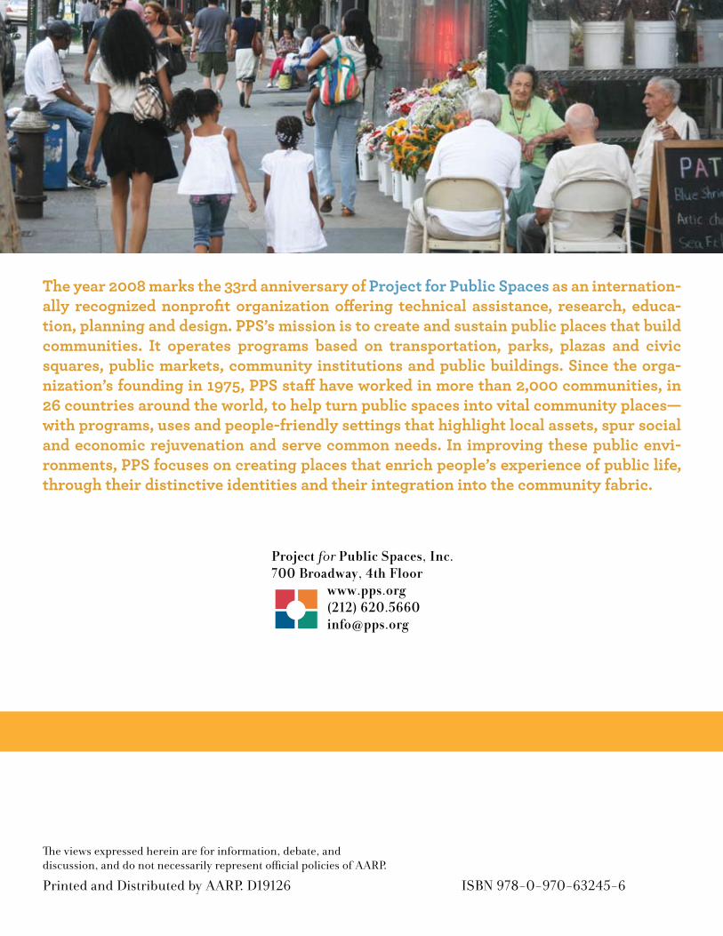
The year 2008 marks the 33rd anniversary of Project for Public Spaces as an internation-ally recognized nonprofit organization offering technical assistance, research, educa-tion, planning and design. PPS’s mission is to create and sustain public places that build communities. It operates programs based on transportation, parks, plazas and civic squares, public markets, community institutions and public buildings. Since the orga-nization’s founding in 1975, PPS staff have worked in more than 2,000 communities, in 26 countries around the world, to help turn public spaces into vital community places—with programs, uses and people-friendly settings that highlight local assets, spur social and economic rejuvenation and serve common needs. In improving these public envi-ronments, PPS focuses on creating places that enrich people’s experience of public life, through their distinctive identities and their integration into the community fabric.
Project for Public Spaces, Inc.700 Broadway, 4th Floor
www.pps.org(212) [email protected]
ISBN 978-0-970-63245-6
The views expressed herein are for information, debate, and discussion, and do not necessarily represent official policies of AARP.
Printed and Distributed by AARP. D19126


![TEMPLATE Roads and Streets SCOPE Map extents …...TEMPLATE FOR LOCAL AUTHORITY STREET GUIDANCE Roads and Streets Design Guidance for [ .] SCOPE Map extents and main places within](https://img.pdfslide.us/doc/110x75/5e8989e46dc14c2eb605b611/template-roads-and-streets-scope-map-extents-template-for-local-authority-street.jpg)