Embed Size (px)
Citation preview

www.ulda.qld.gov.au
Street and movement networkULDA guideline no. 06 April 2012
Guideli
ne un
der r
eview

© Urban Land Development Authority 2012
The information contained herein does not represent Commonwealth, State or Local Government policy. The Urban Land Development Authority does not guarantee or make any representations as to its accuracy or completeness, nor will they accept any responsibility for any loss or damage arising from its use.
This guideline is printed on 100 per cent recycled paper.
Guideli
ne un
der r
eview

Contents
Introduction .................................................................................... 1
» Purpose of guideline ....................................................................................... 1
Street network ................................................................................2
» Trunk connectors ............................................................................................4
» Neighbourhood street network .......................................................................4
» Centre street network .....................................................................................6
» Industrial street network ................................................................................7
Street types and specifications .......................................................8
» Trunk connector ..............................................................................................9
» Neighbourhood street network ..................................................................... 10
Ð Neighbourhood connector street ............................................................. 10
Ð Neighbourhood access streets ..................................................................11
Ð Neighbourhood lane ................................................................................ 13
» Centre street network ................................................................................... 14
Ð Centre connector street ............................................................................ 14
Ð Centre access street ................................................................................. 15
Ð Centre lane ............................................................................................... 16
» Industrial street network .............................................................................. 17
Ð Industrial connector street ....................................................................... 17
Ð Industrial access street ............................................................................ 18
Appendix A - Functions of streets ................................................. 19
» Pedestrian and people activity ...................................................................... 19
» Cycle activity .................................................................................................20
» Public transport activity ................................................................................20
» Motor vehicle activity .................................................................................... 21
» Parking ......................................................................................................... 21
Guideli
ne un
der r
eview

Purpose of guideline
This guideline outlines the Urban Land Development Authority (ULDA) standards for the planning and design of street and movement networks within Urban Development Areas (UDAs). This guideline should be read in conjunction with the provisions of UDA development schemes, Interim Land Use Plans (ILUPs), and the other ULDA guidelines listed below.
» Guideline no. 5 Ð Neighbourhood Planning and Design
» Guideline no. 9 Ð Centres
» Guideline no. 10 Ð Industry and Business Areas
» Guideline no. 13 Ð Engineering Standards
» Guideline no. 14 Ð Environment and Natural Resources Sustainability
This guideline contains specific street types for the three main land uses typically planned in UDAs: neighbourhoods, mixed use centres and industrial areas.
In consultation with the ULDA and other relevant parties, applicants may propose alternative solutions that differ from the standards set out in this guideline but achieve the relevant UDA-wide criteria or related provisions of ILUPs.
Introduction
1 Street and movement network guideline 06
Guideli
ne un
der r
eview

Street network
Street and movement network design standards
This guideline addresses only the UDA street network shown in Table 1. The highest order street in the UDA street network is the trunk connector. Below this the UDA street network comprises connector streets, access streets and lanes. The characteristics of these lower order streets and lanes vary depending on whether they are located in neighbourhoods, mixed-use centres or industrial areas.
Table 1 UDA street network
UDA street network
Trunk connector
Neighbourhood Centre Industrial
Neighbourhood connector street Centre connector street Industrial connector street
Neighbourhood access streets Centre access street Industrial access street
Rear lane Centre lane N/A
The UDA street network encourages interconnectivity between communities and neighbourhoods. A permeable street network enables all users to have access to the street network. Appendix A provides further information on the needs of street users and some basic planning and design considerations.
The detailed design considerations for each street or lane in the UDA street network are provided in the street types and specifications section of this guideline.
Table 2 presents the arterial road network. These roads are not addressed in this guideline. Table 2 provides the overall road hierarchy context for the UDA street network, and is provided for information only.
Table 2 Arterial road network
Arterial road network Reference
FreewayAs per Austroads classification and not specifically addressed in this guideline. Standards for these higher order roads are referred to in ULDA Guideline 13: Engineering standards.
Primary arterial
Secondary arterial
2Street and movement network - Final Draft
Guideli
ne un
der r
eview

Figure 1 shows the overall street network, presenting the interaction between the arterial road network and the ULDA street network to which this guideline applies. This figure classifies the UDA street and movement network into trunk connectors, connectors, access streets and lanes for neighbourhoods, centres and industrial areas.
Figure 1 Street network diagram
3 Street and movement network guideline 06
Guideli
ne un
der r
eview

Trunk connectors
Trunk connectors provide connections between neighbourhoods and other key activity areas and can include bus and cycling routes. Trunk connectors generally pass between rather than through neighbourhoods. Direct property access from this street type is limited as trunk connectors typically carry high volumes of traffic.
The function of a trunk connector is demonstrated in Figure 2.
Neighbourhood street network
Figure 2 displays the neighbourhood street network, which correlates with ULDA Guideline no. 5 Neighbourhood Planning and Design. The neighbourhood street network consists of:
» Neighbourhood connector streets Ð provide connections to neighbourhood destinations and typically include bus and cycling routes.
» Neighbourhood access streets Ð provide high levels of connectivity within neighbourhoods and provide direct access to properties.
» Neighbourhood lanes Ð provide direct property access, usually within high density developments or to the back of residential properties.
Figure 2 Neighbourhood street network diagram
4Street and movement network guideline 06
Guideli
ne un
der r
eview

Neighbourhood street networks should be designed to achieve the following requirements:
» Networks should form a highly connected, legible and permeable grid pattern to provide choices in routes and mode of movement
» Networks should promote safe traffic and transport movements and provide direct pedestrian and cyclist access to centres, focal points and transit opportunities
» Street network design should minimise culs-de-sac, and where they are used:
Ð Limit their length so the end point is visible from the access point to prevent drivers inadvertently turning into a dead-end
Ð Ensure turning heads are capable of accommodating a three point turn by a medium-rigid vehicle (e.g. garbage and fire trucks)
Ð Ensure street design provides pedestrian and cyclist connections through to other streets or to pedestrian/cycle paths
» Ensure driveways are kept to a minimum width to maintain footpath connectivity
» Use rear laneways to minimise driveways on higher order roads and main streets.
» Footpaths should:
Ð be provided on at least one side of all but the lowest order streets and lanes, particularly any street that provides a through route for pedestrian and cyclists
Ð be provided on both sides of trunk connector streets, streets providing access to centres and other key destinations, and all streets where the adjoining residential density is 30 dwellings per hectare or greater
Ð generally be a minimum of 1.5metres wide to allow pedestrians, including those with mobility difficulties or prams, to walk two abreast or comfortably pass each other (a reduced width of 1.2 metres may be acceptable where pedestrian volumes are low).
A street network requires efficient and effective intersection design to provide network connectivity. General intersection requirements are:
» Minimise the use of roundabouts, particularly within neighbourhoods
» Ensure intersection design indicates the presence of the intersection on all approaches
» Use tight kerb radii at intersections to shorten pedestrian crossing distances and reduce vehicle speeds.
Refer to Section: Street types and specifications for neighbourhood street network specifications.
5 Street and movement network guideline 06
Guideli
ne un
der r
eview

Centre street network
Figure 3 shows an indicative centre street network, ULDA Guideline no. 9 Centres should be consulted for further information about centre planning and design. As shown, the centre street network consists of:
» Centre connector streets Ð provide limited direct property access, and support a high level of pedestrian and cycle activity
» Centre access streets Ð provide direct property access to commercial centre activities, while supporting a high level of pedestrian and cycle activity
» Centre lanes Ð provide access to the rear of buildings, mainly for loading and delivery vehicles.
Complete Streets (2010) defines centre streets as accommodating activity vital for the surrounding community, including a combination of retail, business, employment, school, leisure and related activity. Centre connector streets can be highly active streets, both during the day and at night.
To provide adequate network connectivity, the following design requirements apply:
» Networks should form a highly connected, legible and permeable grid pattern to provide choices in route and mode of movement
Figure 3 Centre street network
» Networks promote safe traffic and transport movements and provide direct pedestrian and cyclist access to key activities, focal points and transit opportunities
» Pedestrian and people-orientated activities are a priority, so pedestrian connections, with adequate pedestrian space, should be provided.
» Cyclists' needs must be met through street design:
Ð Commuter cyclists must have on-road options to minimise the effect of cyclists on the motor vehicle traffic flow
Ð Alternative routes are essential to accommodate casual cyclists, usually provided by shared pedestrian and cycle pathways located separate to the road carriageway.
» Public transport connections must be frequent and easily accessible by all street users.
» Ensure driveways are kept to a minimum width to maintain footpath connectivity.
» Centre connector streets should have limited direct access, to ensure the safety of all street users.
The requirements for intersections within the centre street network are similar to the neighbourhood intersection requirements detailed in the neighbourhood street network section. The detailed specifications of centre streets are provided in the street types and specifications section of this guideline.
6Street and movement network guideline 06
Guideli
ne un
der r
eview

Industrial street network
Figure 4 displays the industrial street network and complements ULDA Guideline no. 10 Industry and business areas. The industrial street network consists of:
» Industrial connector streets Ð provide a route via industrial access streets to industrial destinations.
» Industrial access streets Ð provide direct access to properties and have a footpath on one side of the street for pedestrian connectivity.
Industrial street networks have a different purpose to neighbourhood and centre street networks, with a greater focus on motor vehicle and freight transport than pedestrian and cycle movement. The following design requirements apply to industrial street networks:
» A highly connected, legible and permeable grid pattern to provide direct access to industrial and business users
» Promote safe traffic and transport movements and provides direct pedestrian and cyclist access to industrial areas
» Use of dead-end streets and cul-de-sacs should be avoided. Formal turn facilities should provide enough room for the freight design vehicles to manoeuvre
» On street parking should be line-marked and clear zones used to improve street access and line of sight issues.
The requirements for intersections within the industrial street network are similar to the neighbourhood intersection requirements detailed in the: Neighbourhood street network section. The street types and specifications section provides the detailed specifications for industrial connector and access streets.
Figure 4 Industrial street network
7 Street and movement network guideline 06
Guideli
ne un
der r
eview

Street types and specifications
The UDA street types fall into four categories, as outlined in Table 1 and listed below:
» Trunk connector
» Neighbourhood
Ð Connector street
Ð Access streets
Ð Lane
» Centre
Ð Connector street
Ð Access street
Ð Lane
» Industrial
Ð Connector street
Ð Access street.
The following sections provide street characteristics and a typical cross-section for all the streets listed above.
8Street and movement network guideline 06
Guideli
ne un
der r
eview
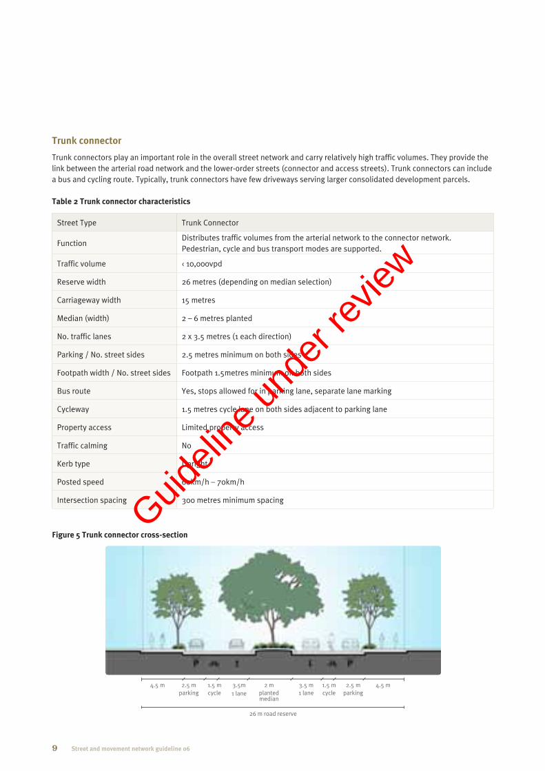
Trunk connector
Trunk connectors play an important role in the overall street network and carry relatively high traffic volumes. They provide the link between the arterial road network and the lower-order streets (connector and access streets). Trunk connectors can include a bus and cycling route. Typically, trunk connectors have few driveways serving larger consolidated development parcels.
Table 2 Trunk connector characteristics
Street Type Trunk Connector
FunctionDistributes traffic volumes from the arterial network to the connector network. Pedestrian, cycle and bus transport modes are supported.
Traffic volume Ü 10,000vpd
Reserve width 26 metres (depending on median selection)
Carriageway width 15 metres
Median (width) 2 Ð 6 metres planted
No. traffic lanes 2 x 3.5 metres (1 each direction)
Parking / No. street sides 2.5 metres minimum on both sides
Footpath width / No. street sides Footpath 1.5metres minimum on both sides
Bus route Yes, stops allowed for in parking lane, separate lane marking
Cycleway 1.5 metres cycle lane on both sides adjacent to parking lane
Property access Limited property access
Traffic calming No
Kerb type Upright
Posted speed 60km/h Ð 70km/h
Intersection spacing 300 metres minimum spacing
Figure 5 Trunk connector cross-section
26 m road reserve
2 m planted median
3.5 m 1 lane
2.5 m parking
2.5 m parking
1.5 m cycle
1.5 m cycle
4.5 m 4.5 m 3.5m 1 lane
9 Street and movement network guideline 06
Guideli
ne un
der r
eview

Neighbourhood street network
Neighbourhood connector street
Table 3 Neighbourhood connector street characteristics
Street Type Neighbourhood Connector Street
FunctionNeighbourhood connector streets connect neighbourhood destinations including shops and parks, provide access to the surrounding road network and can include a bus and cycling route.
Traffic volume Ü 7,500vpd
Reserve width 19.5 metres
Carriageway width 9.5 Ð 12 metres
Median (width) No
No. traffic lanes 2 x 3.5 metres (1 each direction)
Parking / No. street sides 2.5 metres minimum on one or both sides
Footpath width / No. street sides 1.5 metres minimum on both sides
Bus route Where required as part of overall network, provide additional lane widths.
Cycleway No
Property access Direct property access
Traffic calming No
Kerb type Upright
Posted speed Default 50km/h, unless signed otherwise.
Intersection spacing 120 metres minimum spacing
Figure 6 Neighbourhood connector street cross-section
19.5 m road reserve
7 m 2 lanes
2.5 m parking
2.5 m parking
3.75 m 3.75 m
10Street and movement network guideline 06
Guideli
ne un
der r
eview

Neighbourhood access streets
Neighbourhood access streets provide high levels of connectivity throughout the neighbourhood, are of an appropriate length and have carriageways with sufficient width to enable safe and efficient through vehicle movement in association with on-street parking and passing opportunities. Streets and driveways are designed to ensure motorists are able to enter on-site parking space/s in one movement in a forward gear.
Table 4 Neighbourhood access streets characteristics
Street Type Neighbourhood access streets
7.5 metres1 5.5 metres2
Function Provide direct residential property access. Also allow for vehicle, pedestrian and cyclist connectivity.
Traffic volume Ü 5,000vpd Ü 2,500vpd
Reserve width 15 metres 13 metres
Carriageway width 7.5 metres3 5.5 metres3
Maximum block length 150 metres 150 metres
Median (width) No No
No. traffic lanes Varies, minimum one traffic lane with passing opportunities
Varies, minimum one traffic lane with passing opportunities
Parking / No. street sides2.5 metres minimum on one or both sides
2.5 metres minimum on one side, staggered to provide passing opportunities
Footpath width / No. street sides Footpath 1.5metres minimum on one or both sides4
Footpath 1.5 metres minimum on one or both sides..
Bus route No No
Cycleway No No
Property access Direct property access (vehicle access may be via rear lane)
Direct property access (vehicle access may be via rear lane)
Traffic calming No No
Kerb type Roll Over Roll Over
Posted speed Default 50km/h, unless signed otherwise.
Default 50km/h, unless signed otherwise.
Intersection spacing na na
1 A parking analysis plan* is required to demonstrate compliance with the above standards if
the proposed neighbourhood access street will provide access to:
» lots less than 12.5m wide, or
» a multiple residential development including up to 6 dwellings.
Refer to the ULDA practice note for more information on parking analysis plans.
2 Generally only acceptable where:
» net residential densities do not exceed 20 dwellings per hectare
» on-street parking can be provided in accordance with ULDA Guideline No 7 Low rise
buildings
» where adequate passing opportunities can be provided to accommodate predicted
traffic flows, and
» where supported by a parking analysis plan.
3 Carriageway widths may need to be increased to provide adequate vehicle manoeuvring
space, particularly where on-street parking is provided opposite driveways.
4 For additional information see ULDA practice note on footpath provision in residential
subdivisions.
11 Street and movement network guideline 06
Guideli
ne un
der r
eview

Figure 7 Neighbourhood access street Ð 7.5m cross-section
15 m road reserve
7.5 m 3.75 m 3.75 m
Figure 8 Neighbourhood access street Ð 5.5 m cross-section
13 m road reserve
5.5 m 3.75 m 3.75 m
12Street and movement network guideline 06
Guideli
ne un
der r
eview

Neighbourhood lane
(refer to ULDA Practice Note no.12 Rear lanes: design and development for detailed design guidance)
Table 5 Neighbourhood lane characteristics
Street Type Neighbourhood lane
FunctionLanes provide direct access to properties including for refuse collection and other service vehicles. Lanes typically provide rear access to garages but can also provide "front door" access to loft apartments and other small dwellings.
Traffic volume Ü 500 vpd
Reserve width 6.5 metres
Carriageway width 5.5 metres
Median (width) No
No. traffic lanes 2 (1 each direction)
Parking / No. street sides No
Services Yes
Footpath width / No. street sides No
Bus route No
Cycleway No
Property access Direct property access
Traffic calming No
Kerb type Flush
Posted speed Default 50km/h, unless signed otherwise.
Intersection spacing na
Figure 9 Neighbourhood lane cross-section
6.5 m road reserve
0.5 m5.5 m0.5 m
13 Street and movement network guideline 06
Guideli
ne un
der r
eview
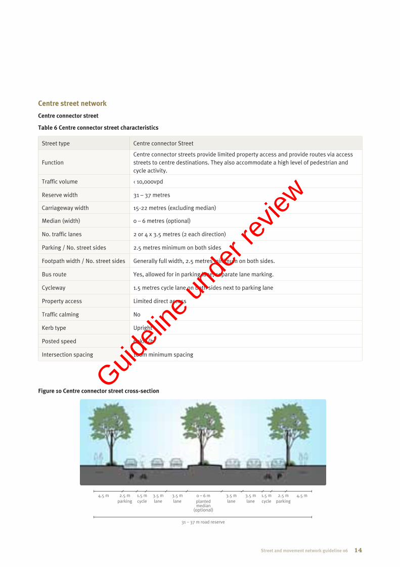
Centre street network
Centre connector street
Table 6 Centre connector street characteristics
Street type Centre connector Street
FunctionCentre connector streets provide limited property access and provide routes via access streets to centre destinations. They also accommodate a high level of pedestrian and cycle activity.
Traffic volume Ü 10,000vpd
Reserve width 31 Ð 37 metres
Carriageway width 15-22 metres (excluding median)
Median (width) 0 Ð 6 metres (optional)
No. traffic lanes 2 or 4 x 3.5 metres (2 each direction)
Parking / No. street sides 2.5 metres minimum on both sides
Footpath width / No. street sides Generally full width, 2.5 metres minimum on both sides.
Bus route Yes, allowed for in parking lane, separate lane marking.
Cycleway 1.5 metres cycle lane on both sides next to parking lane
Property access Limited direct access
Traffic calming No
Kerb type Upright
Posted speed 60km/h
Intersection spacing 100m minimum spacing
Figure 10 Centre connector street cross-section
31 Ð 37 m road reserve
0 Ð 6 m planted median
(optional)
2.5 m parking
2.5 m parking
1.5 m cycle
1.5 m cycle
3.5 m lane
3.5 m lane
3.5 m lane
3.5 m lane
4.5 m 4.5 m
14Street and movement network guideline 06
Guideli
ne un
der r
eview

Centre access street
Table 7 Centre access street characteristics
Street Type Centre Access Street
FunctionCentre access streets provide direct property access to commercial centre activities, and support a high level of pedestrian and cycle activity.
Traffic volume Ü 5,000vpd
Reserve width 24 metres
Carriageway width 15 metres
Median (width) No
No. traffic lanes 2 x 3.5 metres (1 each direction)
Parking / No. street sides 2.5 metres minimum on both sides
Footpath width / No. street sides Generally full width, 1.5 metres minimum on both sides.
Bus route Not usually allowed, but if needed provide additional lane widths as required.
Cycleway 1.5 metres cycle lane on both sides next to parking lane
Property access Direct property access
Traffic calming No
Kerb type Upright
Posted speed Default 50km/h, unless signed otherwise.
Intersection spacing 100 metres minimum spacing
Figure 11 Centre access street cross-section
24 m road reserve
2.5 m parking
2.5 m parking
1.5 m cycle
1.5 m cycle
3.5 m 1 lane
3.5 m 1 lane
4.5 m 4.5 m
15 Street and movement network guideline 06
Guideli
ne un
der r
eview

Centre lane
Table 8 Centre lane characteristics
Street Type Centre Connector Street
FunctionCentre lanes provide access to the rear of buildings, including access for loading and delivery vehicles. Centre lanes are not intended as an alternative route option for through traffic, and should not be designed as such.
Traffic volume Ü 1,000 vpd
Reserve width 9 Ð 10 metres
Carriageway width 6 Ð 7 metres
Median (width) No
No. traffic lanes 2 x 3 Ð 3.5 metres (1 each direction)
Parking / No. street sides No, short-term loading/unloading excepted
Footpath width / No. street sides Full width where provided.
Bus route No
Cycleway No
Property access Direct property access
Traffic calming No
Kerb type Flush
Posted speed Default 50km/h, unless signed otherwise.
Intersection spacing 50 metres minimum spacing
Figure 12 Centre lane cross-section
9 Ð 10 m road reserve
1.5 m 3 Ð 3.5 m
1 lane 1.5 m 3 Ð 3.5 m
1 lane
16Street and movement network guideline 06
Guideli
ne un
der r
eview

Industrial street network
Industrial connector street Table 9 Industrial connector street characteristics
Street Type Industrial connector street
FunctionProvide routes via access streets to industrial destinations. Low requirement for cyclists and pedestrians accessibility.
Traffic volume Ü 7,500 vpd
Reserve width 25 metres
Carriageway width 15 metres
Median (width) No
No. traffic lanes 2 x 3.5 metres (1 each direction)
Parking / No. street sides 2.5 metres parking lane both sides
Footpath width / No. street sides Footpath 1.5 metres minimum on one side
Bus route No
Cycleway 1.5 metres cycle lane on both sides next to parking lane
Property access Limited direct access
Traffic calming No
Kerb type Roll over
Posted speed 60km/h
Intersection spacing 150 metres minimum spacing
Figure 13 Industrial connector street cross-section
25 m road reserve
2.5 m parking
2.5 m parking
1.5 m cycle
1.5 m cycle
3.5 m 1 lane
3.5 m 1 lane
5 m 4.5 m
17 Street and movement network guideline 06
Guideli
ne un
der r
eview

Industrial access street
Table 10 Industrial access street characteristics
Street Type Industrial Access Street
FunctionIndustrial access streets provide direct access to properties. Parking lanes are to be provided on both sides to cater for employees and a footpath on one side of the street.
Traffic volume Ü 5,000 vpd
Reserve width 20 metres
Carriageway width 12 metres
Median (width) No
No. traffic lanes 2 x 3.5 metres (1 each direction)
Parking / No. street sides 2.5 metres parking lane both sides
Footpath width / No. street sides Footpath 1.5 metres minimum on one side
Bus route No
Cycleway No
Property access Direct property access
Traffic calming No
Kerb type Roll Over
Posted speed Default 50km/h, unless signed otherwise.
Intersection spacing 100 metres minimum spacing
Figure 14 Industrial access street cross-section
20 m road reserve
2.5 m parking
2.5 m parking
3.5 m 1 lane
3.5 m 1 lane
4 m 4 m
18Street and movement network guideline 06
Guideli
ne un
der r
eview

Figure 15 Hastings Street, Noosa (Complete Streets, 2010)
Figure 16 Complete pedestrian space (Complete Streets, 2010)
19 Street and movement network guideline 06
Appendix A Functions of streets
The function of streets is an extremely important part of planning UDAs, as they provide the main linkages within and between neighbourhoods, centres, industrial and other areas of a community.
This appendix provides a brief overview of the functions and uses of streets.
Complete Streets (IPWEAQ, 2010) outlines the importance and function of street design within urban, residential and industrial developments, identifying the following principal functions that a street must fulfil:
» Pedestrian and people activity
» Cycle activity
» Public transport activity
» Motor vehicle activity
» Parking.
This appendix describes the planning and design principles that have formed the basis of the ULDA street network hierarchy. Next Generation Planning (SEQ Council of Mayors, 2010) has also informed the UDA street and movement network described in this guideline.
Pedestrian and people activity
Pedestrian activity encourages healthy living, social interaction and is an environmentally friendly travel option. It has a positive impact on communities and neighbourhoods, promoting vibrancy and street activities.
Pedestrians can use streets to commute, for fitness and health activities or to access adjacent land uses, such as public parks or commercial precincts. However, people do not use streets exclusively for travelling.
Other activities undertaken by people in streets include street-side dining, shopping, sitting to rest, busking and entertaining, waiting for public transport, exercising and recreation, playing, social interaction.
These activities require space and supporting infrastructure including seating, bus stops and shelters, play space, shade structures, drinking fountains, gathering space, public artwork and outdoor dining.
To ensure equitable access for people with disabilities, infrastructure must be designed to provide continuous accessible paths, appropriate path widths for wheelchairs, provide mobility aids and vision-impaired guidance. Refer to AS/NZS 1428.1-2009 for detailed guidance on design for access for people with a disability.
Providing space for pedestrians alongside streets, to facilitate pedestrian movement and create activity opportunity is essential in modern street design. Figure 15 and Figure 16 provide examples of a high quality pedestrian environments within a street. The street types outlined in this document create pedestrian space, and encourage people to use streets for activities including active transport.
Guideli
ne un
der r
eview

Cycle activity
Encouraging active transport modes such as cycling should be a priority, by providing a safe and comfortable environment for cyclists, providing network connections and by managing interactions with other street users (refer Figure 17).
There are three general types of cyclists: commuter, long distance and local area cyclists. Commuter and long distance cyclists typically travel at higher speeds. Therefore, it is easier to incorporate their needs on busy streets. Local area cyclists generally have lower skill levels and as such, require wider cycle lanes, separated paths and slower vehicle traffic flows. All three groups have different requirements, and in order to encourage this mode of active transport, provisions need to be made while designing streets to incorporate safe and efficient cycle routes.
Cyclists also require supporting infrastructure such as end-of-trip facilities including secure parking, showers and bike lockers and bicycle-parking facilities.
Figure 17 Cycling activity (Complete Streets, 2010)
Public transport activity
Public transport is a key activity in successful street networks, and provides a more environmentally friendly transportation option than private vehicle transport. Bus services will be the predominant public transport mode using the street network; however provisions should be made for taxi services in appropriate locations such as centres.
Street design should provide public transport routes that integrate with the greater public transport network and with local pedestrian and cycle networks to increase use of public transport. Service coverage and access need to be integrated into street and movement design of neighbourhoods, to enable effective public transport use.
Providing public transport infrastructure such as peak-hour bus lanes on key routes will also increase the use of public transport. Incorporating room in street space for bus stopping bays and indent stops will decrease the conflict between buses and other vehicles. Supporting infrastructure including stops, shelters and bike parking facilities will also provide passengers with comfort and safety, and need to be integrated into street design.
20Street and movement network guideline 06
Guideli
ne un
der r
eview

Figure 18 Narrow streets aiding low speed environment (Complete Streets, 2010)
Motor vehicle activity
Street design for motor vehicle activity must provide for the safe movement of motor vehicles and access to property while managing traffic speed to ensure the safety of all street users.
Providing adequate capacity for anticipated use is a major design consideration, as well as designing streets to passively control the speed of motor vehicle traffic and reduce unnecessary motor vehicle movements (i.e. rat running).
Motor vehicles travelling at lower speeds are more safely able to integrate with other street users and transport modes. Speed control is achieved through speed limits and, where appropriate, should be built into street geometry by designing streets and networks to have short straights and short distances between intersections, lane widths, street-scaping and on-street parking (see figure 18).
A key objective of street design is to provide access to adjoining properties. Access must be controlled in certain environments (such as streets with high levels of pedestrian activity) where it is desirable to reduce the interaction between turning vehicles and other street users.
Providing safe sight distances is also critical and must satisfy the relevant standards in the Austroads Guide to Road Design. Other design requirements such as horizontal alignment grades, vertical alignment grades and cross fall must also comply with Austroads.
The configuration of the carriageway depends on the function of the street and its users.
Parking
Parking for motor vehicles is a major consideration for street design. Key objectives include: avoid obstructing other street users, balance supply and demand of parking requirements, provide accessible parking, manage parking zones and time limits to impact positively on the street vibrancy and on other street users.
Parking can be classified into two categories:
» On-street parking
» On-site parking.
On-street parking can be uncontrolled, or controlled via time limits or metering, influencing vehicle turn over. On-site parking is required to be provided in accordance with ULDA development schemes and guidelines.
In high activity areas and other appropriate locations, parking lane space should also accommodate taxi stands. Motorcycle and motor scooter parking spaces may be provided at locations according to forecast demand. Provision must be made for commercial loading/delivery vehicles as well as waste collection vehicles.
Parking lane widths must be sufficient to avoid obstruction of other street users, such as cyclists in adjoining cycle lanes.
For more detailed guidance, refer to AS2890.1 for off-street parking, AS2890.5 for on-street parking, and the Queensland Manual of Uniform Traffic Control Devices (MUTCD).
21 Street and movement network guideline 06
Guideli
ne un
der r
eview

Guideli
ne un
der r
eview

Contact Us
Visit our website at: www.ulda.qld.gov.au
Write to us at:Urban Land Development AuthorityGPO Box 2202Brisbane QLD 4001
Telephone us: 1300 130 215Fax us: (07) 302 44199
Guideli
ne un
der r
eview