Embed Size (px)
Citation preview

Street Addressing
Standards and Guidelines
for the State of Georgia
Prepared by
Georgia Spatial Data Infrastructure GIS Coordinating Committee
Framework Transportation Technical Working Group August 2000

Street Addressing Standards and Guidelines
i
FOREWORD
This guideline was produced by The University of Georgia’s Office of Information Technology
Outreach Services (ITOS) under contract with Georgia’s GIS Coordinating Committee as part of
a collaborative effort to develop the State of Georgia’s core Geographic Information System
(GIS) base map.

Street Addressing Standards and Guidelines
ii
TABLE OF CONTENTS 1 INTRODUCTION .......................................................................................................................1
2 PURPOSE..................................................................................................................................2
3 GOALS .....................................................................................................................................2
4.0 TERMINOLOGY.....................................................................................................................3
4.1 Physical Address & Mailing Address ........................................................................3
4.2 Parsing........................................................................................................................3
4.3 Address Database.......................................................................................................4
4.4 Roads Database with Address Ranges (RDAR) ........................................................4
5.0 REVIEW OF EXISTING STANDARDS......................................................................................6
5.1 United States Postal Service (USPS) ............................................................................6
5.2.0 US Census Bureau (USCB)........................................................................................7
5.2.1 Roads Database (RDAR) ........................................................................................7
5.2.2 Address Database....................................................................................................9
5.2.3 Alphabetic Case ......................................................................................................9
5.3 National Emergency Numbering Association (NENA) ..............................................10
5.3.1 Address Database..................................................................................................10
5.3.2 Roads Database (RDAR) ......................................................................................10
5.4 Georgia Department of Transportation (GDOT) ........................................................11
5.5 American Planning Association (APA) ......................................................................11
6.0 RECOMMENDED STANDARDS AND GUIDELINES FOR ADDRESSING..................................12
6.1 ESTABLISHING A REFERENCE POINT AND BASELINES ..................................................12
6.1.1 Establishing a Reference Point .............................................................................12
6.1.2 Establishing Baselines ..........................................................................................12
6.2.0 STREET NAMING..........................................................................................................13
6.2.1 General Principles of Assigning Pre-Directions ......................................................15
6.2.2 General Principles of Assigning Street Names ........................................................15
6.2.3 General Principles of Assigning Street Types..........................................................19
6.2.4 General Principles of Assigning Quadrants .............................................................19
6.3.0 STREET NUMBERING ...................................................................................................21
Street Addressing Standards and Guidelines
iii
6.3.1 Assign Each Street an Order .................................................................................21
6.3.2 Assign Each Street a Parent ..................................................................................22
6.3.3 Assign Address Ranges.........................................................................................23
6.3.3(a) First Order Streets..............................................................................................23
6.3.3(b) Higher Order Streets..........................................................................................24
6.3.3(c) Special Cases .....................................................................................................26
6.3(a) Advantages of This System .....................................................................................28
6.3(b) Disadvantages of This System.................................................................................30
6.4.0 HOUSE NUMBERING ....................................................................................................30
6.4.1 Corner Lots...............................................................................................................31
6.4.2 Stacked Addresses....................................................................................................31
6.4.3 Apartments and Duplexes ........................................................................................31
6.4.4 Businesses ................................................................................................................32
6.4.5 Mobile Home Parks..................................................................................................32
7 APPENDICES ..........................................................................................................................33
7.A RECOMMENDED DATABASE DESIGNS ...........................................................................33
7.A.1 Recommended Design of Address Database (Minimum Content) .........................33
7.A.2 Recommended Design of RDARs (Minimum Content) .........................................34
7.A.3 Justification for Width and Data Type Recommendations .....................................35
7.B STREET TYPES WITH DESCRIPTIONS ............................................................................38
7.C POTENTIAL ADDRESS DATA SOURCES..........................................................................42
8. SELECTED REFERENCES.......................................................................................................43

Street Addressing Standards and Guidelines
iv

Street Addressing Standards and Guidelines
1
1 INTRODUCTION
Because the property address is a fundamental component of any government service delivery
system, it must be assigned through a logical and consistent procedure. The importance of
proper addressing cannot be overstated; during an emergency it can mean, quite literally, the
difference between life and death. Additionally, addressing helps define educational and
political districts, and affects the quality of services available to citizens. A logical and
consistent addressing system, therefore, can tangibly improve the quality of life in a community.
Unfortunately, the importance of the addressing task is frequently overlooked, resulting in
addressing schemes that are often unorganized or incomprehensible and that lead to inefficient
and ineffective governmental and commercial service delivery. But easily understood addressing
systems are not simple to design and maintain. Local governments have found that managing a
coherent addressing system can be difficult even under the best circumstances. During periods of
steep growth, existing flaws in addressing systems -- duplicate street names, unnecessary name
changes, non-sequential numbering, etc. – can cause small inconsistencies to propagate through
the system, creating even larger problems. Currently, many Georgia counties do not use
municipal style addresses (e.g., 101 E Main St SE), but conversion from the old system of rural
routes and boxes is inevitable as more counties implement 911 systems. The standards and
guidelines in this document are designed to make the process a little easier and to help make
addressing across the State of Georgia more consistent.
Citizens usually bear the cost of poorly designed addressing systems through inefficient
government services and through lost business when potential customers are unable to locate an
establishment. Poorly designed addressing systems result in postage increases, delivery delays,
lost parcels, and even loss of property and life. Yet ironically, those most likely to oppose the
revamping of older addressing systems (which may contain errors likely to interfere covertly
with services) are the local citizens and businesses themselves, who may be required to revise
subscriptions and billing, or to reprint labels, stationery, and the like. As a result, public officials
who are aware of the dangers posed by addressing-system problems may discover that their
constituencies do not support change. Education and public involvement are essential elements

Street Addressing Standards and Guidelines
2
in developing a comprehensive solution. Citizens must know why it is necessary to readdress,
and they must be provided an opportunity to participate in the process.
Today there are various tools to help implement a new addressing system or revamp an existing
one. Although Geographic Information System (GIS) tools will not make the political process
any easier, they certainly make technical implementation much simpler, faster, and more
consistent. This document was written with GIS implementation in mind; most, if not all, of the
applications described in this document will be applicable to the non-digital world, but the
standards herein were developed primarily for electronic implementation.
2 PURPOSE
In the development of this document, political concerns were necessarily attenuated, while safety
and efficiency concerns remained paramount. The purpose of this document, Street Address
Standards and Guidelines for the State of Georgia, is to assist county and municipal
governments with implementing and maintaining a consistent, safe, useful, and standardized
addressing system.
3 GOALS
The primary goal of this report is to provide local government agencies with a complete set of
addressing guidelines, so that addressing may become more consistent statewide and efficiency
of government services such as emergency response may be improved.
Secondary goals include:
• To improve the quality of life for residents of Georgia through improved delivery of mail
and services;
• To project a positive and progressive image to residents, prospective residents, and
developers;
• To make address location simpler for residents and businesses;

Street Addressing Standards and Guidelines
3
• To emphasize the importance of a consistent, county-wide addressing system;
• To promote the use of GIS for creation and maintenance of a roads database with address
ranges (RDAR).
4.0 TERMINOLOGY
In order to understand the following recommended standards, one must first understand the
difference between a physical address and a mailing address, as well as the difference between
an address database and a roads database with address ranges (RDAR).
4.1 Physical Address & Mailing Address
A physical address describes where a dwelling, business, or lot is physically located, not
necessarily where mail is received. For instance, a person may reside at 123 N America St NE,
but receive mail at PO Box 128. The PO box is a mailing address, while 123 N America St NE
is a physical address.
4.2 Parsing
During data entry, both physical and mailing addresses should be broken down into as many
components as possible, a process known as parsing. See examples of parsed and unparsed
physical address formats below. (Note: For mailing addresses, an additional column should be
included for PO boxes).

Street Addressing Standards and Guidelines
4
Unparsed Address Database NAME ADDRESS Doe, Jane C., Dr. 123 N America St NW Smith, Joe B. Jr. 125 Oak St SE Jones, Terry 357 Magnum Rd NE Parsed Address Database LAST-NAME
MI FIRST-NAME
TITLE NAME- SUF
HOUSE-NUM
PRE-DIR ST-NAME ST- TYPE
QUAD
Doe C Jane Dr 123 N America St NW Smith B Joe Jr 125 Oak St SE Jones Terry 357 Magnum Rd NE
4.3 Address Database
An address database, for the purposes of these guidelines, is a database that contains specific
physical addresses, which describe a location for receipt of emergency services, utilities, et al.
It is not uncommon for agencies and businesses to maintain databases containing both physical
and mailing addresses, as service and billing locations are not always identical. This document
is written with concern for physical addresses only, but the recommendations given for physical
addresses can be closely followed for mailing addresses as well.
4.4 Roads Database with Address Ranges (RDAR)
The differences between an address database and a roads database with address ranges
(RDAR) are just as significant as the differences between a physical address and a mailing
address. As mentioned above, an address database is a collection of any number of specific
addresses, each of which correlates to one (and only one) spot on the earth. A RDAR, on the
other hand, records the acceptable range of addresses for every street or portion of a street in an
area. For example, a specific address might appear in an address database as 124 N America
Street NW. A RDAR might locate this address on the following road segment: N America St
NW 100 101 158 159 (i.e., the section of N America St NW extending from addresses 100 and
101 to addresses 158 and 159).

Street Addressing Standards and Guidelines
5
Figure 4.0: GIS map with address database and RDAR A roads database with address ranges (RDAR) allows an address database to be mapped. Here, the two physical addresses 215 Connell Rd SW and 312 Connell Rd SW (identified from the address database, inset upper left) are located on a section of Connell Road SW spanning nos. 212-322 on the right, and nos. 211-321 on the left (identified from the RDAR, inset lower right).
With the advent of GIS, the RDAR is becoming more and more common. It is often used by 911
centers to dispatch calls, and is typically used to create a Master Street Address Guide (MSAG).†
The RDAR is invaluable to GIS applications and is commonly used to map events (such as
crimes) or approximate location of utility customers. The RDAR does not replace the address
database; it is a GIS enhancement which can transform a standard address database into a very
powerful tool for geographic and visual analysis.
† NENA defines an MSAG as “A database of street names and house number ranges within their associated
communities defining Emergency Service Zones (ESZs) and their associated Emergency Service Numbers (ESNs)
to enable proper routing of 9-1-1 calls.”
Street Addressing Standards and Guidelines
6
5.0 REVIEW OF EXISTING STANDARDS
To develop these guidelines and standards, many existing standards were examined, with
primary consideration given to data published by the U.S. Postal Service (USPS), U.S. Census
Bureau (USCB), National Emergency Numbering Association (NENA), American Planning
Association (APA, formerly ASPO), and the Southern Association of State Planning and
Development Agencies. Upon review, it became apparent that existing systems were not
mutually compatible, especially in the area of database design, each having been developed for a
particular scope of work. The recommendations made in this publication are an attempt to take
the best features from all current systems and combine them into a single standard that will best
serve local governments and the State of Georgia.
Furthermore, this publication does not attempt to encompass the general issue of database
design, but focuses only on the addressing portion of a database. However, as a general rule,
database design in the age of inexpensive data storage should implement parsing of data as much
as possible. As an example, an address should be broken down into 10 different data fields (see
Appendix, sec. 7.A.1); names should arguably be broken down into 6 data fields. Parsing of data
typically results in more consistent data entry and will always produce a more versatile database.
5.1 United States Postal Service (USPS)
USPS Publication 28, Postal Addressing Standards, is primarily devoted to describing how a
mailing address should appear on a parcel; no standards are provided for address data storage,
address range storage, street naming, or street addressing. There are, however, abbreviations
listed in Appendices B, C, F, and G of Publication 28, which are recommended for data entry
into both address databases and address range databases. (Note: Although abbreviations listed in
Publication 28 are shown in all uppercase letters, it is recommended that a mixture of uppercase
and lowercase letters be used in an address database or RDAR. This issue is discussed in greater
detail in section 5.2.3.)

Street Addressing Standards and Guidelines
7
5.2.0 US Census Bureau (USCB)
The USCB publishes standards for both address databases (Computer-readable Census Address
List) and address range databases (Topologically Integrated Geographic Encoding and
Referencing system, or TIGER).
5.2.1 Roads Database (RDAR)
Most RDARs in use today originate from the USCB TIGER/Line files, although in many cases
the data has been enhanced and/or updated. TIGER/Line files are relatively complex extracts
from the Census TIGER database utilizing linked tables related by unique identifiers -- these
concepts must be understood in order to work with TIGER/Line files successfully. With TIGER
data, address range information for a road segment (spatial object) is stored separately from the
data file containing the spatial object itself (see LaMacchia). However, since both tables have a
unique identifier in common, the two tables can be easily linked so that address range
information can be accessed via the spatial object. This is a very desirable and very common
way of storing data, as it provides coherent and comprehensive organization and reduces file
sizes.
The diagram below illustrates the concept of linking tables. This concept will be mentioned
again in section 5.4, where it is recommended in conjunction with the DLG-F dataset to be
adopted as a state base map layer and used and maintained by Georgia DOT in the fall of 2000.

Street Addressing Standards and Guidelines
8
Spatial Objects (Centerlines)
Figure 5.2.1: Linking Tables with Unique Identifiers
Since TIGER data was built to accommodate addressing, the roads database design
recommended in section 7.A.2 closely resembles the design of the TIGER/Line file’s Record
Type 1. The most noticeable differences between the Record Type 1 data dictionary and the data
dictionary recommended here are the removal of several unrelated data fields, inclusion of a field
for the full street name (see section 6.2.0) and narrower strictures on data types. For example,
the TIGER design allows alphabetical characters to be entered into the address range fields,
which is not recommended here. The format described in this document should better serve local
governments in Georgia by forcing more conscientious data entry; and since these standards are
stricter than TIGER standards, data can easily be converted to Census Bureau format if
necessary.
Road Characteristics Table
Feature_ID Surface R.O.W. Lanes
281037 Paved 60 2
281038 Paved 60 2
Street Centerline Table
Length Feature_ID
227.34 281037
253.68 281038
Address Information Table
Feature_ID FRADDL FRADDR
281037 100 101
281038 200 201

Street Addressing Standards and Guidelines
9
5.2.2 Address Database
The recommended format for an address database, however, is not patterned after the USCB
design, because the Computer-readable Census Address List used by the USCB is not parsed
enough to serve the needs of local governments. USCB format confines the entire street name to
one field of 43 characters, which must encompass pre-direction, street name, street type and
quadrant. This format is inadequate for most local government applications, because greater
data-entry-level parsing allows for easier and more versatile recombination of data
(concatenation) when needed. Conversely, if data-entry field options are insufficient, parsing at
a later time becomes a complex and labor-intensive process. Therefore, it is better to have more
fields of data than originally deemed necessary than to make the mistake of having too few.
Parsing of data during entry also helps reduce data-entry errors, which is crucial to most local
government applications, especially where GIS and 911 are concerned. (See the table in section
4.2 for an example of a parsed database and Appendix 7.A.1 for the recommended address
database design.)
5.2.3 Alphabetic Case
The data entry style of mixed uppercase and lowercase letters, which the US Census Bureau
uses, is recommended because it allows for a more versatile database than single-case formats
can produce. For data entry purposes, it is recommended that the first letter of each word or
abbreviation be entered in uppercase. Some words or abbreviations (such as McCrae or NE) will
include additional uppercase letters after the initial.
Strong consideration was given to this recommendation, as it diverges from the all-uppercase
style currently used for most road signs and maps. However, this recommendation can be made
in good conscience, since most GIS software packages include tools to convert from mixed-case
to all-uppercase or -lowercase, but do not include tools capable of correctly and consistently
converting all-uppercase or -lowercase addressing data to mixed-case.
Street Addressing Standards and Guidelines
10
5.3 National Emergency Numbering Association (NENA)
5.3.1 Address Database
The address database design recommended by the National Emergency Numbering Association
closely resembles the design recommended here. NENA recognizes the need to parse data so as
to assure versatility and reduce data entry errors. Most of the recommendations in Appendix
7.A.1 for an address database design comply with NENA standards, except that the street name
field width of 40 or 60 characters, recommended by NENA, is here reduced to 30. In order to
minimize confusion, and to avoid problems with data entry and sign construction, the street
name portion of a full street name (see section 6.2 for explanation of these terms) should never
exceed 30 characters.
5.3.2 Roads Database (RDAR)
NENA does not make recommendations about RDARs per se. NENA standards do, however,
make recommendations about the format of an MSAG; and since the MSAG is usually an output
from a RDAR, the layout of the roads database can be inferred from the MSAG design. The
MSAG design recommended by NENA closely compares to the format recommended here for
the RDAR. The most significant difference is field width for street names and field type for low
and high address ranges. NENA recommendations allow for alphabetical characters in the high
and low range, whereas the format recommended here will allow only numbers. The purpose of
this recommendation is, once again, to reduce data entry errors and to force compliance with
numbering recommendations, which do not allow for alphabetical characters. NENA standards
also allow for alphabetical characters in a ZIP code. Since letters should never occur within US
ZIP codes, we recommend that this field also be strictly numerical.
Street Addressing Standards and Guidelines
11
5.4 Georgia Department of Transportation (GDOT)
In the fall of 2000, Georgia DOT will adopt and begin using Georgia’s DLG-F transportation
database. For the State of Georgia this is by far the most comprehensive and accurate road
database available. At the time of this report (August 2000) there is no address information
available with the DLG-F database, but conflation of TIGER address ranges and Atlanta
Regional Commission (ARC) address ranges to the DLG-F data is currently underway for the
Atlanta Metropolitan Area. Furthermore, there are tentative plans to perform the conflation of
TIGER address ranges to the DLG-F database on a statewide basis. Even if the conflation does
not take place on a statewide basis, the DLG-F data set is probably the best place to start for
anyone looking to create a RDAR.
Since every road segment (arc) in the DLG-F database has a permanent unique identifier
(Feature ID) it lends itself to being easily linked to separate tables. Just as the TIGER road
segments are linked to the Record Type 1 table through the TIGER Line ID (TLID), any local
address range databases could be linked to the DLG-F data via the Feature ID. Therefore,
anyone creating a separate address range database should include a Feature ID in their database
design. This field should have a format and values identical to those used in the DLG-F data set
(see 7.A.2).
5.5 American Planning Association (APA)
In 1978, the American Society of Planning Officials (now called the APA) published a
comprehensive review of addressing systems, Report No. 332: Street-Naming and Property-
Numbering Systems, focusing primarily on street naming conventions and various addressing
methods. Because the report was written when very few cities had computers, it understandably
omits database design. Still, many recommendations given for street naming and for
establishing reference points and baselines are mirrored in this document with little or no
modification. However, the hybrid addressing system and database design recommendations are
direct results of intervening changes in computer technology.
Street Addressing Standards and Guidelines
12
6.0 RECOMMENDED STANDARDS AND GUIDELINES FOR ADDRESSING
Appendix 7.A of this document contains recommended database designs, with justifications, for
both address databases and RDARs. They list the bare minimum number of data fields required.
There may be many other elements necessary to meet your local requirements, but practically
every address database and every RDAR should have the fields included here. To enhance the
RDAR, for example, it may be necessary to add a field for emergency service zones, in order to
meet the needs of the 911 center. Furthermore, for the address database, it may be necessary to
add a field designating an address as commercial or residential. (For more ideas about additional
data elements you may wish to include, refer to the publications and other sources referenced in
sections 5, 7.C, and 8 of this document.)
6.1 ESTABLISHING A REFERENCE POINT AND BASELINES
6.1.1 Establishing a Reference Point
The process of assigning street names and numbers should begin by establishing a reference
point for the county. The reference point should be an appropriate locale such as (but not
necessarily) a prominent intersection in the county seat. Ideally, the reference point will be near
the center of the county. It is highly recommended that the reference point be the intersection of
two streets.
6.1.2 Establishing Baselines
The two streets that intersect at the reference point are called baselines. The baselines should
continue all the way to the county line — even if this requires one or more changes of contiguous
streets en route — thereby dividing the county into four roughly equivalent sections, or
quadrants. In an ideal situation, the baselines will emanate from the reference point in
predominantly N-S and E-W directions.

Street Addressing Standards and Guidelines
13
Figure 6.1: Establish a reference point and baselines
6.2.0 STREET NAMING
Assigning street names is not the most complex part of addressing; but in practice, the task may
appear deceptively simple. The importance of carefully reviewing new street proposals and
understanding their placement in the context of the county road system is fundamental to an
efficient and effective addressing program and cannot be overemphasized.
Problems in assigning street names become manifest as new development occurs and as existing
streets are rerouted or intersect with new streets. As an area grows, a lack of county-wide
coordination and inadequate control and review mechanisms inevitably result in continuous
roads changing names several times, numbering becoming non-sequential, and/or street names
being duplicated. Adherence to the following guidelines should help alleviate such problems in
the future; however, they do little to correct today’s problems if not applied to revamp existing
systems.

Street Addressing Standards and Guidelines
14
To fully understand the language used in the following sections, one must first understand the
anatomy of a full street name, which is comprised of four distinct components. Just as most
people have a first name, middle name, and last name which all combine to form a full name, a
street has a pre-direction, street name, street type, and quadrant which all combine to form a
full street name. Be careful to think of these individual components as you read and interpret
these guidelines. Be aware that, just as not every person has a middle name, not every street will
have a value for all of the components. As far as the database is concerned, every full street
name does have four components, but some components may have a null value. However, every
street must have a non-null street name and street type. Furthermore, every street except
interstate highways and baselines should be assigned a quadrant.
Anatomy of a full street name:
Pre-direction Street Name Street Type Quadrant
S Oak St SW
Deer Run NE
Pre-direction + Street Name + Street Type + Quadrant = Full Street Name:
S Oak St SW
Deer Run NE
6.2.0(a) Pre-direction: Indicates the primary compass direction that a second order street (see
sec. 6.3.1) follows from the baseline (i.e., N, S, E, W).
6.2.0(b) Street Name: The principal identifying component of a full street name, which in most
cases should uniquely distinguish a street from all others (e.g., Oak, Broad).
6.2.0(c) Street Type: Gives some indication of the primary use, length, or shape of the street
(e.g., Lane, Circle).
6.2.0(d) Quadrant: Indicates the street’s location relative to the reference point and baselines
(i.e., NW, NE, SW, SE).

Street Addressing Standards and Guidelines
15
6.2.1 General Principles of Assigning Pre-Directions
6.2.1(a) Use Proper Reference Point
Street pre-directions should be used only to indicate the primary direction that a street travels
from its intersection with the baseline. Even if it has been common practice in a particular
area to assign pre-directions relative to a landmark or major thoroughfare other than the baseline,
this practice should not be allowed, as it will eventually result in confusion. Furthermore, pre-
directions should not be assigned to streets that do not continue across a baseline.
6.2.1(b) Use Proper Format
A street pre-direction should consist of only one primary direction (North, South, East, or
West) and not a combination of two.
6.2.2 General Principles of Assigning Street Names
6.2.2(a) Avoid Duplication
A full street name should be used only once in any county. A street name should also be
unique, except that it is acceptable to have one duplicate street name in closed subdivisions
(those having access via only one or two entry points), and even in these cases such streets must
have a different street type (e.g., Quail Drive, Quail Lane) and one should be a cul-de-sac (or
dead-end) intersecting the other at a perpendicular (or nearly perpendicular) angle. Except in
this manner, street name duplication — regardless of street type or jurisdiction (city, fire, police,
ambulance) — should not occur in any county. Furthermore, duplication should not occur in any
portion of an adjacent county in which a ZIP code is identical to a ZIP code used within the
county in question.
6.2.2(b) Avoid Confusion
Street Addressing Standards and Guidelines
16
A street name should be appropriate, as well as easy to read, spell, and pronounce – even for
children – in an emergency situation.
6.2.2(b.1)
Names which have homonyms (i.e., other words pronounced similarly but spelled differently)
should not be used on any street and certainly not on multiple streets even if the street type is
different (e.g., Steven Lane / Stephen Lane; Disk Drive / Disc Lane).
6.2.2(b.2)
Names that tend to be mispronounced or misspelled or are difficult to pronounce or spell
should not be used (e.g., Javelina, Peony, Weimaraner).
6.2.2(b.3)
Two-word names or one-word names that can be confused as two-word names should not be
used. This avoids the problem of two words being combined into one word, or vice versa, when
entered (e.g., Clearlake, Clear Lake, Brookhaven, Baytree).
6.2.2(b.4)
A street name should not contain directional words such as North, South, East, or West. If they
are used, it is difficult if not impossible to distinguish the pre-direction portion of a full street
name from the street name itself. Northridge is an example of a street name that breaks this rule
as well as the two-word rule above.
6.2.2(b.5)
Street names containing punctuation or special characters (e.g., Fishermen’s, J.F.K.,
Holman-Fuller) should be avoided, as punctuation makes street names unnecessarily
complicated, and some database programs do not gracefully handle punctuation. Furthermore,

Street Addressing Standards and Guidelines
17
words that normally require punctuation should not be used with the punctuation omitted (e.g.,
Fishermens Landing). Apostrophes, hyphens, or dots may be included when necessary (to
avoid confusion, for example), but it is especially important that special characters such as
commas, quotation marks, and asterisks not be used. In the case of numbered streets, such as
First Street or Tenth Avenue, it is recommended that the names be spelled out as opposed to
using numbers with suffixes. This practice allows for the creation of a complete yet strictly
alphabetical index.
6.2.2(c) Avoid Emotion
Except where historically significant; avoid using proper names as street names (e.g., Wilma
Calumet Road). While this naming practice may not cause problems today, it will certainly
create problems in the future if a name change or street closing becomes necessary.
Furthermore, use of a first and last name usually results in an unnecessarily long street name. It
is recognized that many streets already bear names of historically significant individuals and will
continue to do so, but the desire to commemorate local history must be tempered by the ultimate
goal of making street names easy to use for citizens, visitors, and service providers (especially in
the area of emergency services).
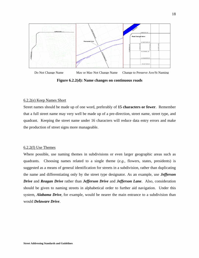
6.2.2(d) Promote Continuity
A continuous street should have one name and one name only throughout its entire length, even
if the street changes direction one or more times. In the case of permanent voids (such as a pond
or closed railroad crossing) where a portion of a road is permanently closed or non-continuous,
the road can have the same name on both sides of the void, if the void can be easily breached by
an alternate route. If, however, a new street is added on the opposite side of a permanent void, in
line or out of line with an existing street, that new street should be given a unique name. Also, it
may be desirable to make exceptions to this “one name” rule in areas where a grid pattern
prevails and streets are named according to their primary direction of travel.
Street Addressing Standards and Guidelines
18
Figure 6.2.2(d): Name changes on continuous roads
6.2.2(e) Keep Names Short
Street names should be made up of one word, preferably of 15 characters or fewer. Remember
that a full street name may very well be made up of a pre-direction, street name, street type, and
quadrant. Keeping the street name under 16 characters will reduce data entry errors and make
the production of street signs more manageable.
6.2.2(f) Use Themes
Where possible, use naming themes in subdivisions or even larger geographic areas such as
quadrants. Choosing names related to a single theme (e.g., flowers, states, presidents) is
suggested as a means of general identification for streets in a subdivision, rather than duplicating
the name and differentiating only by the street type designator. As an example, use Jefferson
Drive and Reagan Drive rather than Jefferson Drive and Jefferson Lane. Also, consideration
should be given to naming streets in alphabetical order to further aid navigation. Under this
system, Alabama Drive, for example, would be nearer the main entrance to a subdivision than
would Delaware Drive.
Do Not Change Name May or May Not Change Name Change to Preserve Ave/St Naming

Street Addressing Standards and Guidelines
19
6.2.3 General Principles of Assigning Street Types
6.2.3(a) Be Consistent
Every street should be assigned a street type. Street types carry certain expectations of the
length, shape, direction, width and other characteristics of a road. These expectations should not
be violated. While many different possibilities for street types exist, the most commonly used
street types are listed and described in Appendix 7.B. (Note: The descriptions are intentionally
broad and in many cases overlapping; they are provided for consideration as guidelines, but are
not official or restrictive.)
6.2.3(b) Avoid Confusion
Maintain a clear distinction between street name and street type. Create an exhaustive list of
street types to be used in your jurisdiction and reserve those words to be used as street types
only. You should not use a full street name of Terrace Drive SW and another full street name of
Spring Terrace NE. Use the word Terrace as a street type or a street name, but not both. A list
of common street types, with their abbreviations and descriptions, is provided in Appendix 7.B.
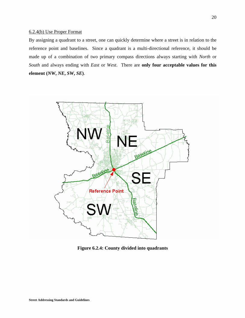
6.2.4 General Principles of Assigning Quadrants
6.2.4(a) Be Consistent
A quadrant should be assigned to every street except interstate highways and streets that
form baselines.
Street Addressing Standards and Guidelines
20
6.2.4(b) Use Proper Format
By assigning a quadrant to a street, one can quickly determine where a street is in relation to the
reference point and baselines. Since a quadrant is a multi-directional reference, it should be
made up of a combination of two primary compass directions always starting with North or
South and always ending with East or West. There are only four acceptable values for this
element (NW, NE, SW, SE).
Figure 6.2.4: County divided into quadrants

Street Addressing Standards and Guidelines
21
6.3.0 STREET NUMBERING
Note: It is not unusual, during the development of a new subdivision, that construction will begin
at both ends of a street and continue in phases toward a common centerpoint. In this situation, it
is very important that addressing be done from the master plan. Otherwise, parent streets
(see section 6.3.2) may be misassigned and it may be necessary to readdress one or both ends of
the completed street.
6.3.1 Assign Each Street an Order
After a reference point and baselines have been established, a tree branch scheme should be used
to assign an order to each street. The baseline roads act as the trunk of the tree and are referred
to as first order streets. Any street that intersects a baseline street is designated a second order
street. Any street that intersects a second order street, and that is not a baseline or second order
street itself, is designated as a third order street. This process should continue until all streets
are assigned an order.
Figure 6.3.1: Assign each street an order

Street Addressing Standards and Guidelines
22
6.3.2 Assign Each Street a Parent
After every street is assigned an order, each must also be assigned a parent. The importance of
the parent is to designate a starting point for the addressing sequence. Each street must be given
one and only one parent, which will be of one order lower (numerically) than itself. If a street
intersects more than one street of an immediately lower order, that street will be assigned a
parent based upon which intersection is closest to the reference point via a straight-line (not
road distance), as this value is easy to calculate and will never change.† If the intersection
closest to the reference point is shared by more than one street of an immediately lower order,
the parent will be assigned to the lower order street that intersects its own parent closest to the
reference point.
Figure 6.3.2: Assign each street a parent
† Although it is possible that construction of a new intersection may link a street with a lower-order street closer to
the reference point by straight-line measure, such changes should be ignored once addressing is completed, since all
addresses “down stream” would be affected. Road distance measures, on the other hand, are inherently difficult to
work with, as they require multiple calculations (of values that are continually subject to change).

Street Addressing Standards and Guidelines
23
6.3.3 Assign Address Ranges
For streets of all orders, these three general principles will hold:
1. Numbering should always commence at the intersection of the centerlines, as opposed to
the edge of pavement or right-of-way.
2. Even numbers should be assigned to the right side of streets and odd numbers to the left
side as you travel in the direction of increasing address numbers.
3. Numbers increase as you move away from the reference point and toward the county
boundary.
6.3.3(a) First Order Streets
Baselines should be assigned addresses first. Addressing is accomplished by starting at the
reference point and subdividing the baseline streets into 20’ sections as they extend toward the
county boundary. Each 20’ section should be assigned a pair of sequential whole numbers,
starting with the first section which should receive a value of 100 on the right side and a value of
101 on the left side.
Figure 6.3.3(a): Sequential addressing of a 1st order street

Street Addressing Standards and Guidelines
24
Throughout the entire length of a street, sections should be assigned only according to distance
traveled along the centerline. This means that intersections and blocks should be ignored
during the segmenting process. In some GIS software, this process would be accomplished by
dynamic segmentation. For example, if the distance from the reference point to the county
boundary along a 1st order street is 10 miles (52,800’), there will be a total of 2,640 numbers
assigned along each side of that street (52,800 / 20 = 2,640). Since each side is assigned 2,640
numbers, there will be a total of 5,280 numbers assigned. Because the lowest number used will
be 100, the ending street numbers will be 5380 and 5381.
6.3.3(b) Higher Order Streets
After first order streets are numbered, second order streets should be numbered in a similar
fashion. Any non-baseline street will commence numbering with the address of the parent at
the intersection, and increase or decrease depending on whether the parent-intersection is
central (closer to the reference point) or peripheral (farther from the reference point) when
compared to that street’s other end.
• If the intersection with the parent is closer to the reference point (in a direct line) when
compared with the street’s other terminus, numbers will increase sequentially from the
parent address.
• If the intersection with the parent is farther from the reference point (in a direct line)
when compared with the street’s other terminus, numbers will decrease sequentially from
the parent address.
[For a nontechnical paraphrase of this rule, see general principle 3 in sec. 6.3.3 above.]
For example, in Figure 6.3.3(b)1, Oak St intersects its parent street (S Patterson St) at section
132/133 and proceeds toward a cul-de-sac at a distance farther away from the reference point.
Therefore, Oak Street is assigned increasing numbers beginning with 132/133 at the parent-
intersection. S Patterson St is also a parent to Elk Ln, which intersects it at the 120/121 section.
However, because Elk Ln proceeds toward a cul-de-sac which is closer to the reference point, it
is assigned a decreasing sequence of addresses beginning with 120/121.

Street Addressing Standards and Guidelines
25
Figure 6.3.3(b)1: Sequential addressing of 2nd order streets
Figure 6.3.3(b)2: Numbering proceeds from the more central terminus

Street Addressing Standards and Guidelines
26
If a street continues in two directions from the parent, numbers will increase in one direction (on
that portion which ends at a point farthest from the reference point) and decrease in the other
direction.
Figure 6.3.3(b)3: Sequential Addressing of 3rd order streets
6.3.3(c) Special Cases
In come cases, very short unnamed cul-de-sacs, containing accesses to five or fewer lots, may be
addressed from the centerline of a named street [see fig. 6.3.3(c)1 below].

Street Addressing Standards and Guidelines
27
Figure 6.3.3(c)1: Assigning addresses to an unnamed cul-de-sac
If a street forms a closed loop, addressing should proceed clockwise from the base of the loop
[see fig. 6.3.3(c)2 below].
Figure 6.3.3(c)2: Addressing a closed loop

Street Addressing Standards and Guidelines
28
6.3(a) Advantages of This System
The primary advantage of this addressing system is that it is based totally on mathematical logic
and can therefore be automated, except for designation of the reference point and baselines.
Given an adequate GIS road centerline coverage, it would be possible to use programming logic
to output a fully addressed road coverage.
Since the addressing is done on a countywide basis, future annexations, de-annexations, street
additions or street closings will not cause addressing problems. Furthermore, with this
addressing system it is possible to know approximately how far an address is from the reference
point or from any other address. With block numbering systems, it is impossible to predict your
distance to any address even if numbering by distance is used within the blocks, because a
varying span of numbers must be omitted whenever a new block is reached.
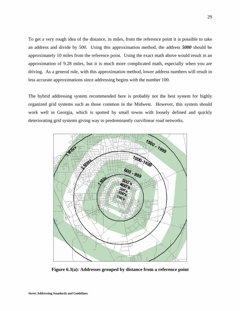
Figure 6.3(a) shows the bull’s-eye pattern of address ranges resulting from the recommended
system. Each mile of street contains approximately 528 addresses. Since the addressing starts at
100, the address 628 should be approximately one road mile from the reference point, and the
address 1156 (628 + 528) should be approximately two road miles from the reference point.
By extrapolating this process, distance to a target address may be estimated from the addressing
sequence, or an address from a known road distance. Just keep in mind that:
1. Numbering starts with 100 rather than 0; and,
2. A pair of numbers is assigned to every 20’ section of road, averaging one address number
per every 10 feet of centerline.
Example One: Estimate the address of a lot 2½ miles from the reference point.
Formula: (Distance in feet / 10) + 100 = Address#
(13,200 / 10) + 100 = 1420
Example Two: Estimate the distance between address 4419 and the reference point.
Formula: (Address# - 100) x 10 = Distance in feet
(4419 – 100) x 10 = 43,190’ or 8.18 miles
Street Addressing Standards and Guidelines
29
To get a very rough idea of the distance, in miles, from the reference point it is possible to take
an address and divide by 500. Using this approximation method, the address 5000 should be
approximately 10 miles from the reference point. Using the exact math above would result in an
approximation of 9.28 miles, but it is much more complicated math, especially when you are
driving. As a general rule, with this approximation method, lower address numbers will result in
less accurate approximations since addressing begins with the number 100.
The hybrid addressing system recommended here is probably not the best system for highly
organized grid systems such as those common in the Midwest. However, this system should
work well in Georgia, which is spotted by small towns with loosely defined and quickly
deteriorating grid systems giving way to predominantly curvilinear road networks.
Figure 6.3(a): Addresses grouped by distance from a reference point
Street Addressing Standards and Guidelines
30
6.3(b) Disadvantages of This System
This addressing system is not “traditional” — that is, city blocks do not serve as its standard unit.
Therefore, when applied to a street grid pattern, it does not result in all addresses between 100
and 200 being on the same block, and thus would likely cause confusion in the initial stages of
use. The confusion would be compounded in a community where streets are named with
numbers, because everyone expects a 250 X Ave address to be somewhere between X Avenue’s
intersections with Second Street and Third Street, for example. However, the confusion
resulting from the change should quickly subside, as sequential numbering is easy to understand
and grid systems in Georgia rarely prevail throughout an entire city (and never throughout an
entire county). If this addressing system is to be used in an area where a grid pattern prevails
with street numbers as names, it is recommended that the street names be changed to something
other than numbers. Street numbering does not work well with a sequential addressing
system.
6.4.0 HOUSE NUMBERING
The final stage of the addressing process is to assign addresses to particular residences,
businesses, and other property. The general rule is to assign the address of the 20’ section of
street aligned with the center of the front of a building or lot (in a line perpendicular to the
centerline of the road). In the majority of cases, especially if a GIS is used, this is a very simple
process involving verification from digital aerial photographs. Yet while it may be possible to
automate the entire process of assigning addresses to road segments, automation of house
numbering is infeasible. Rules must be established for assigning numbers with consistency, but
human judgment will be necessary at various stages of the procedure. When no existing rule
applies workably to a particular situation, let safety and consistency guide the decision making
process. The following sections discuss how to handle the most common situations in which
application of the general rule results in ambiguity.

Street Addressing Standards and Guidelines
31
6.4.1 Corner Lots
Usually, addresses will be assigned from the center of the side of the building where the front
door is located. However, when the front door is obscured or invisible from the road, or the
structure is obviously best reached for emergency purposes by the driveway, assign the property
number based on where the driveway intersects the road .
6.4.2 Stacked Addresses
Houses or trailers behind other houses or trailers sharing a common driveway should be given
separate numbers. The average house is approximately 60 feet long; therefore, there will
normally be at least 3 numbers in front of a house. Assign the first possible number to the
front house and the second number to the next house, etc. This is much preferred over the use
of hyphenated, alphanumeric, or fractional numbering (e.g., 437-2, 437B, 437½).
6.4.3 Apartments and Duplexes
Apartments and all other multi-tenant structures should be numbered by the main building or
main entrance to the complex. Each individual unit should then be given a secondary location
indicator such as the building designator, floor number and unit number. It is preferable that
buildings be lettered, and that floors and apartments be numbered. For example, the
residence at the address 3006 Firehouse Rd, Apt F-1-27 should be the 27th apartment on the 1st
floor of building F. The hyphens in the unit distinguish the 27th apartment on the 1st floor from
the 7th apartment on the 12th floor.
Street Addressing Standards and Guidelines
32
6.4.4 Businesses
Businesses should be addressed like houses or apartments, depending on the layout. If there are
several businesses within the same building, they should be addressed just as apartments are
addressed, except they should be designated as suites (e.g., 2506 Birdy Ln, Ste G257).
6.4.5 Mobile Home Parks
There are two logical methods of addressing mobile home parks. The best choice for a particular
mobile home park will depend on the specifics of the park design. The first choice is to handle
the park as if it were an apartment complex: that is, assign one street address for all mobile
homes and then give each unit a secondary designator that specifies which lot it occupies. The
second choice is to treat internal park streets like any other streets, dividing them into 20’
sections and assigning addresses to the mobile homes just as you would to any other home.
Street Addressing Standards and Guidelines
33
7 APPENDICES
7.A RECOMMENDED DATABASE DESIGNS
The field name recommendations shown below are not critical to database use or compatibility.
No agency referenced in this document used a database with field names matching these
precisely; however, each agency utilized a set of field names closely resembling those described
here. Therefore, there is some flexibility in this area; however, field names should be always
descriptive, and never misleading.
Unlike field names, field widths and field types are critical and do affect compatibility, and
should therefore conform precisely with this standard.
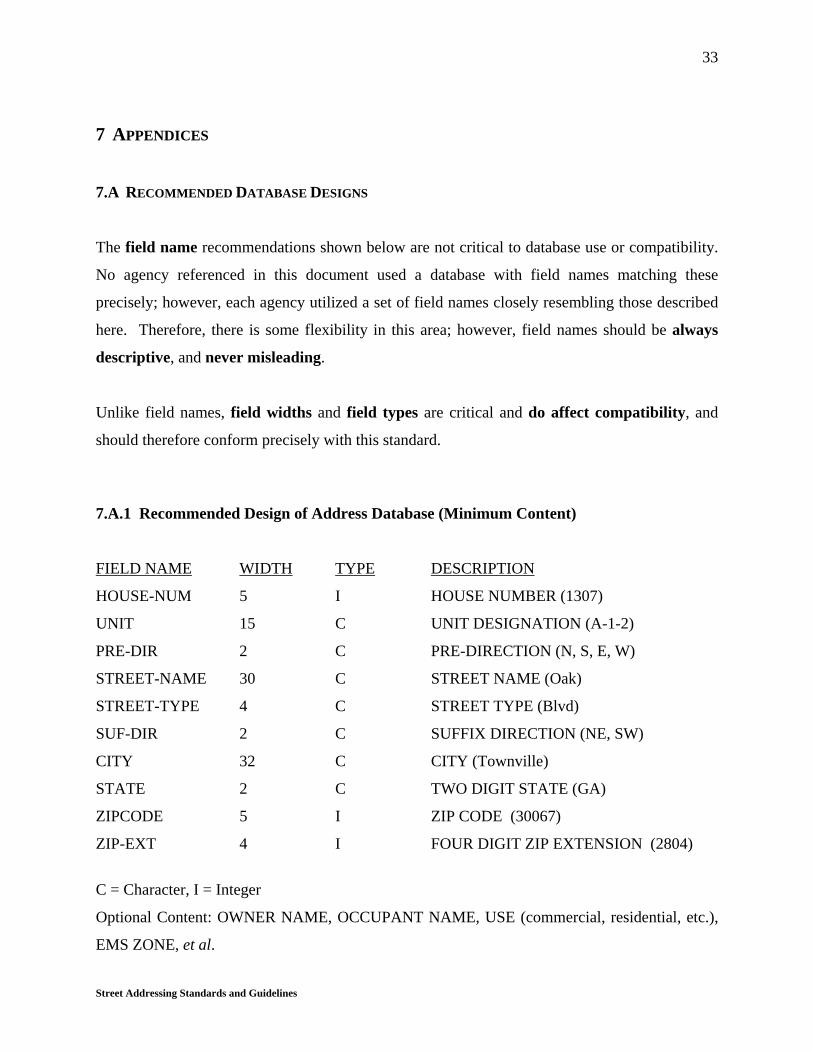
7.A.1 Recommended Design of Address Database (Minimum Content)
FIELD NAME WIDTH TYPE DESCRIPTION
HOUSE-NUM 5 I HOUSE NUMBER (1307)
UNIT 15 C UNIT DESIGNATION (A-1-2)
PRE-DIR 2 C PRE-DIRECTION (N, S, E, W)
STREET-NAME 30 C STREET NAME (Oak)
STREET-TYPE 4 C STREET TYPE (Blvd)
SUF-DIR 2 C SUFFIX DIRECTION (NE, SW)
CITY 32 C CITY (Townville)
STATE 2 C TWO DIGIT STATE (GA)
ZIPCODE 5 I ZIP CODE (30067)
ZIP-EXT 4 I FOUR DIGIT ZIP EXTENSION (2804)
C = Character, I = Integer
Optional Content: OWNER NAME, OCCUPANT NAME, USE (commercial, residential, etc.),
EMS ZONE, et al.

Street Addressing Standards and Guidelines
34
7.A.2 Recommended Design of RDARs (Minimum Content)
FIELD NAME WIDTH TYPE DESCRIPTION
FRADDL 5 I LEFT ADDRESS FROM (100)
TOADDL 5 I LEFT ADDRESS TO (128)
FRADDR 5 I RIGHT ADDRESS FROM (101)
TOADDR 5 I RIGHT ADDRESS TO (129)
FEDIRP 2 C PRE- DIRECTION (N, S, E, W)
FENAME 30 C FEATURE (STREET) NAME (Elm)
FETYPE 4 C FEATURE (STREET) TYPE (Rd)
FEDIRS 2 C SUFFIX DIRECTION (NE)
FSTNAME 40 C FULL STREET NAME (N Elm Rd NE)
ALIAS_1 40 C FSTNAME ALIAS (Jones Memorial Dr)
*FEAURE_ID 10 C Unique permanent feature identifier
C = Character, I = Integer
* Only used in the case of a separate address range database that will be linked to a road
centerline coverage such as the DLG-F data.
Optional Content: LEFT EMS ZONE, RIGHT EMS ZONE, JURISDICTION (city, county),
RIGHT FIRE ZONE, LEFT ZIP CODE, RIGHT ZIP CODE, ALIAS 2, et al.

Street Addressing Standards and Guidelines
35
7.A.3 Justification for Width and Data Type Recommendations
HOUSE-NUM
Width: If one pair of addresses is assigned for every 20’ of centerline, a five-digit system will
accommodate a road length of over 189 miles. No Georgia county has a single road
longer than 189 miles; therefore, no more than 5 digits will ever be needed.
Type: To reduce data entry errors, ease indexing, and ensure database compatibility, address
numbers should not include alphabetic characters, punctuation, or other special
characters.
UNIT
Width: If proper abbreviations are used, a width of 15 spaces should allow for entry of building
numbers, suites, apartment numbers, or combinations thereof. Where possible hyphens
should be used to separate the building, floor, and unit.
Type: A character field type, the most liberal of all data types, is necessary here to
accommodate letters and words such as Bldg F Ste 2 or Apt G-1-2. Standard
abbreviations from USPS Publication 28 should be used with no punctuation or special
characters.
PRE-DIR & FEDIRP
Width: If these guidelines are followed there will only be 4 possible entries for this item (N, S,
E, W). These entries require a width of only one character. Though it is not
recommended, it is recognized that some may want to use combinations of the primary
directions, such as NE or SW. For this reason the database design recommended here
allows for two characters. This same width is recommended by NENA.
Type: A character data type is necessary to enter valid data.
STREET-NAME & FENAME
Width: Though some standards suggest a width greater than 30 characters to accommodate
existing names, we suggest that a street name longer than 30 characters should be
changed in order to reduce data entry errors and to ensure complete and easily readable
roadsigns.
Street Addressing Standards and Guidelines
36
Type: A character data type is necessary to enter valid data.
STREET-TYPE & FETYPE
Width: If recommended abbreviations are used, street types should be no longer than 4
characters. The same width is suggested by NENA, USPS, and USCB.
Type: A character data type is necessary to enter valid data.
SUF-DIR & FEDIRS
Width: If these guidelines are followed, there will only 4 possible entries for this item; NE, NW,
SE, SW. These entries require a width of only two characters. This same width is
recommended by NENA.
Type: A character data type is necessary to enter valid data.
CITY
Width: A width of 32 characters allows for any city name in the state of Georgia to be entered
without using abbreviations. This same width is recommended by NENA.
Type: A character data type is necessary to enter valid data.
STATE
Width: A width of 2 characters allows for all state abbreviations recommended by the USPS to
be entered. The same width is suggested by NENA, USPS, and USCB.
Type: A character data type is necessary to enter valid data.
ZIPCODE
Width: All ZIP codes are comprised of 5 numbers plus a possible extension. The ZIP Code
should be stored here without the extension. The same width is suggested by NENA,
USPS, and USCB.
Type: An integer data type will prevent alphabetical characters and punctuation from being
accidentally or intentionally entered into the ZIPCODE field, where they do not belong.
ZIP-EXT

Street Addressing Standards and Guidelines
37
Width: All ZIP code extensions are comprised of 4 numbers. The same width is suggested by
NENA, USPS, and USCB.
Type: An integer data type will prevent alphabetical characters and punctuation from being
accidentally or intentionally entered into the ZIP-EXT field, where they do not belong.
FRADDL, TOADDL, FRADDR, TOADDR
Width: This field has the same recommended width as the HOUSE-NUM since it will contain a
possible house number.
Type: This field has the same recommended type as the HOUSE-NUM since it will contain a
possible house number.
FSTNAME
Width: If recommendations in this guideline are followed strictly, a full street name will never
exceed 40 characters [see 6.2.2(e) regarding street name portion of a full street name].
Type: A character data type is necessary to enter valid data.
ALIAS_1
Width: This field has the same recommended width as FSTNAME.
Type: A character data type is necessary to enter valid data.

Street Addressing Standards and Guidelines
38
7.B STREET TYPES WITH DESCRIPTIONS
Alley (Aly)
A short, narrow passage commonly found between close buildings and not used for through
traffic.
Avenue (Ave)
A thoroughfare running principally in an east-west direction and usually terminating at a north-
south running street. (Note: Although this directional arrangement is the recommended standard,
some cities or counties may already have established grid systems in which avenues run N-S and
streets run E-W. In any case, avenues should never run parallel to streets.)
Boulevard (Blvd)
A street divided by a landscaped center or median, often flanked by sidewalks, and generally
designated with an alphabetical name (rather than a number).
Bypass (Byp)
A thoroughfare specially designed to allow nearly uninterrupted travel around the periphery of a
congested area.
Causeway (Cswy)
A roadway elevated above wet ground or water.
Circle (Cir)
A short street that intersects another street only once and terminates in a closed loop [see fig.
6.3.3(c)2].
Court (Ct)
A relatively short, uninterrupted dead-end street.
Street Addressing Standards and Guidelines
39
Crossing (Xing)
A roadway that traverses an important feature such as a railroad, waterway, mountain pass, or
gorge. (Note: In many cases, crossing is a historical designation for what was once the only
route of transport over a prominent feature. Many roadways, therefore, retain this designation
even if that feature is now passable at many points or has ceased to exist.)
Drive (Dr)
A curvilinear street of appreciable length which continues through to other rights-of-way.
Expressway (Expy)
A high-speed, limited-access divided highway for through traffic.
Extension (Ext)
This street type is not recommended, because it is often incompatible with database standards. If
it must be used, it should never be combined with another street type. For example, if Laurel
Boulevard is a wide roadway in town with a median, which changes to an un-divided roadway
with narrow lanes for a short distance after a “dogleg”, the narrower portion may be designated
Laurel Extension, but never Laurel Boulevard Extension.
Freeway (Fwy)
A high-speed, limited-access divided highway for through traffic.
Highway (Hwy)
A designated state or federal highway, usually designed to accommodate a large proportion of
relatively high-speed traffic between cities. U.S. routes are also designated as highways.
Interstate (Int)
A road of the highest order which crosses state boundaries, characterized by limited access
(usually merge/exit rather than signal controlled), wide right-of-way, and a through-traffic
preference. This type is also used to designate a seamless extension of such a road (such as a
spur or bypass) which does not cross state lines.

Street Addressing Standards and Guidelines
40
Lane (Ln)
A relatively short, uninterrupted street ending in a cul-de-sac.
Loop (Loop)
A short street that begins at and ends into the same parent street at two different points.
Parkway (Pky)
A special scenic street or park drive.
Pass (Pass)
A thoroughfare allowing access around or between obstacles.
Path (Path)
A non-urban roadway for low-speed traffic.
Place (Pl)
A relatively short, uninterrupted dead-end street.
Plaza (Plz)
An urban roadway accessing several commercial centers; also used in industrial parks.
Point (Pt)
A roadway allowing access to a bluff, dock, landing, scenic overlook, peninsula, or other
terminal point.
Road (Rd)
A limited thoroughfare that is frequently used and often allows heavy traffic volume. A road
may run in any direction, and is normally non-urban although it may extend through an urban
area.

Street Addressing Standards and Guidelines
41
Spur (Spur)
A relatively short dead-end street, usually allowing access to a staging area or to other types of
transportation.
Street (St)
A thoroughfare running principally in a north-south direction and usually terminating at an east-
west running avenue. (Note: Although this directional arrangement is the recommended
standard, some cities or counties may already have established grid systems in which streets run
E-W and avenues run N-S. In any case, streets should never run parallel to avenues.)
Terrace (Ter)
A roadway flanked by a decline, often with an incline on the opposite side, and in many cases
overlooking a river, gorge, park, or other scenic area.
Trail (Trl)
Any curvilinear street.
Walk (Wlk)
A thoroughfare designed to accommodate vehicular and pedestrian traffic, usually with access to
recreational areas or storefronts.
Way (Way)
A widely applied thoroughfare designation, usually utilized in residential areas for aesthetic
purposes.

Street Addressing Standards and Guidelines
42
7.C POTENTIAL ADDRESS DATA SOURCES
Practically every state agency, county, and city in the state of Georgia has a database containing
addresses along with related information. Such databases might include utility customers,
property owners, building permits, crime records, et al. These are all good examples and sources
of specific address information; however, they do very little or nothing to help establish spatial
relationships among these addresses. Without intimate local knowledge it is impossible to
determine the spatial relationship, such as direct- or driving-distance, between any two addresses
with a high level of confidence. To establish spatial relationships between addresses, it is
necessary to have a GIS road centerline coverage with address range attributes, referred to in
this document as a roads database with address ranges (RDAR).
Unfortunately, the RDAR is much less common than the address database. The most widely
used RDAR would be the Topologically Integrated Geographic Encoding and Referencing
(TIGER) system developed and maintained by the USCB. TIGER data is comprehensive —
that is, it contains address data for practically every part of the United States where such data
exists. However, because the TIGER data encompasses the entire US, many imperfect or
incomplete records have been assimilated. The Census Bureau cannot track every address
change or road addition in the nation. City, county, and regional government agencies such as
Regional Development Centers (RDCs) are better suited for the task of keeping record of street
additions and address ranges. Unfortunately, not every city, county, or RDC has the resources to
develop a detailed RDAR. Thus, there is great disparity in the scope and quality of data
available at the local level, and even high quality data can be unwieldy if it exists only in paper
form.
In summary, TIGER data is readily available for practically the entire United States, but the
quality is unpredictable for local level use. Locally created data is not comprehensive and may
range in quality from excellent to poor depending on the care that was taken in developing the
data.
Street Addressing Standards and Guidelines
43
8. SELECTED REFERENCES
Carl Vincent Institute of Government. Cobb County Addressing Report. Athens, GA: The
University of Georgia, 1992.
Centre County Street Naming and Addressing Policy. Centre County, PA: Centre County Board
of County Commissioners, nd.
Corwin, Margaret A. Street-Naming and Property-Numbering Systems (Report No. 332).
Chicago: American Society of Planning Officials, 1978. ASPO is now the American
Planning Association (APA).
Information Technology Outreach Services. DLG-F Data Dictionary: Transportation. Athens,
GA: The University of Georgia, 1998.
LaMacchia, Robert A., et al. TIGER/Line® Files, 1998: Technical Documentation. Washington,
DC: U.S. Department of Commerce, 1998.
Miller, Harold V. A Guide to Street Naming and Property Numbering. nl: Tennessee State
Planning Commission, 1951. Reprinted by Southern Association of State Planning and
Development Agencies, 1960.
National Emergency Number Association (NENA) Data Standards Subcommittee. NENA-02-
001: Recommended Formats for Data Exchange. nl: NENA, June 1993.
Property Identification Task Force of the Salt Lake County Council of Governments. Guidelines
for Property Identification within the Salt Lake Metropolitan Area. Salt Lake City: Salt
Lake County Public Works Department, Development Services Division, 1984.
Street Naming and Property Numbering Systems: A Technical Manual. Little Rock: Metroplan,
1985.
Subcommittee on Cultural and Demographic Data. Address Data Content Standard. nl: np,
1999.
United States Postal Service. Publication 28: Postal Addressing Standards. Washington, DC:
USPS, 1995.


![[XLS]... Read Here - Ohio EPA Homeepa.ohio.gov/Portals/30/vap/docs/databases/DERR Database... · Web viewPrograms DERR Database qrypublicInfo DERR ID Name Alias Address City PostalCode](https://img.pdfslide.us/doc/110x75/5b093fa47f8b9a93738d8c15/xls-read-here-ohio-epa-databaseweb-viewprograms-derr-database-qrypublicinfo.jpg)