Embed Size (px)
Citation preview
ABSTRACT
The major roof pendants of the easternSierra Nevada, including the Bishop Creek,Pine Creek, Mount Morrison, Deadman Pass,Gull Lake, and part of the Northern RitterRange and Log Cabin Mine pendants, arecomposed of continental-margin rocks rang-ing in age from Middle(?) Cambrian to mid-dle(?) Permian. This group of pendants ap-parently is separated from all other exposuresof Paleozoic rocks by faults, forming a geo-logic and geographic entity here referred to asthe Morrison block. Here, for the first time, acommon stratigraphy, consisting of 10 forma-tional units, one named herein, is recognizedthroughout the pendants of the Morrisonblock, providing a basis for new correlationsand regional interpretations.
Middle(?) Cambrian through Ordovicianrocks of the Morrison block compare closelywith rocks exposed south of Miller Mountainin west-central Nevada, suggesting paleogeo-graphic continuity along an originally linearbelt. In both areas rocks of this age are repre-sented by deep-water, continental-margin se-quences that contrast significantly with thedominantly platform deposits in the White-Inyo Range to the east. Devonian rocks,which in the Morrison block are representedby a submarine-fan system, can be traced intosubmarine channels in the western InyoMountains and thence onto the shelf in theeastern Inyo Mountains, providing a tie be-tween these areas.
Eugeoclinal rocks now composing the Antlerbelt are distal equivalents of rocks in the Mor-rison block that were deposited and deformed
during the Late Devonian–Early MississippianAntler orogeny at a considerable distance to thewest. Later, in post-Early Permian time, rocksof the Morrison block were deformed, rocks ofthe Antler belt were emplaced against the Mor-rison block, and the facies boundaries andstructural belts defined here were offset onnorthwest-trending dextral faults.
INTRODUCTION
Paleozoic metasedimentary rocks are presentin numerous roof pendants and wall-rock septa inthe eastern Sierra Nevada of east-central Califor-nia. These rocks have been mapped and generallydescribed in a number of previous investigations,but the regional stratigraphy, lateral variations,and correlation with strata in other areas have notbeen previously documented. As a result, the pa-leogeographic and tectonic significance of theserocks has remained unclear. New mapping andstratigraphic investigations throughout the east-ern Sierra Nevada have shown that a consistentstratigraphy, representing a common geologichistory, is present in a series of pendants extend-ing about 115 km northwestward from the south-ern end of the Bishop Creek pendant to just southof Conway Summit (Fig. 1). The stratigraphy ofthese pendants can be correlated with or linkedby facies with continental-margin rocks in west-central Nevada, miogeoclinal rocks in the White-Inyo Range to the east, and eugeoclinal rocks inthe Roberts Mountains allochthon (Antler belt) tothe west (Fig. 1). These relationships provide abasis for a better understanding of the nature ofthe North American continental margin duringPaleozoic time, and allow recognition of faciesbelts that can be employed in restoration of theoriginal early Paleozoic continental margin.
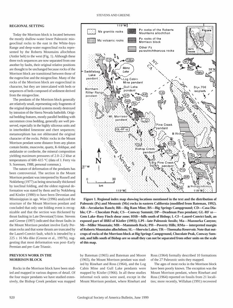
Although Paleozoic rocks in the eastern Sierra
Nevada pendants can now be correlated withrocks in surrounding areas, they are separatedfrom them by faults, inferred faults beneathmore recent deposits, or faults thought to havebeen present prior to intrusion of Mesozoicgranitic rocks. These rocks therefore are inter-preted to form a discrete structural block, al-though they do not constitute a terrane as definedby Howell et al. (1985). We refer to these rockscollectively as the Morrison block because themost complete stratigraphic sequence is exposedin the Mount Morrison pendant. The concept ofthe Morrison block is somewhat similar to thatof the Owens terrane proposed by Nokleberg(1983), but we believe that differences in the de-finition would be large enough to cause confu-sion if the name Owens terrane or block wereapplied here. The Morrison block includes pen-dants that we have mapped and studied in detail,including the Bishop Creek pendant (Fig. 2),Mount Morrison pendant (Fig. 3), Gull Lakependant (Fig. 4), and part of the Log Cabin Minependant (Fig. 5). It also includes areas that wehave studied in less detail, including the PineCreek, part of the Northern Ritter Range, andDeadman Pass pendants, and several smalleroutcrops including a limestone mass south ofConway Summit, calcareous sandstone near BigSprings Campground, shale near ArculariusRanch, and limestone in the hills south of Bishop(Fig. 1). Rocks in the Big Pine Creek pendant(Fig. 1) are not included in the Morrison blockbecause the rocks exposed there are very similarto coeval rocks in the White-Inyo Range, andthey are older than any rocks in the other roofpendants, making comparison impossible.Rocks in the Big Ram Mine area northwest ofIndependence (Fig. 1) also are excluded from theMorrison block because they compare mostclosely with rocks of the central Inyo Mountains.
919
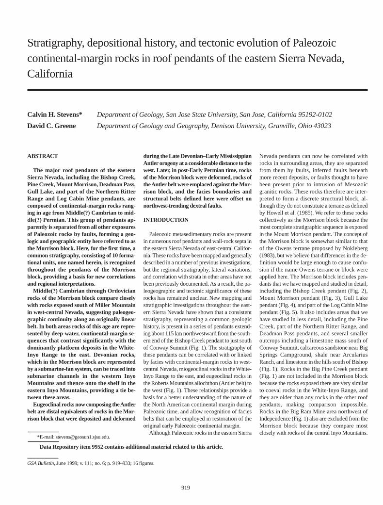
Stratigraphy, depositional history, and tectonic evolution of Paleozoic continental-margin rocks in roof pendants of the eastern Sierra Nevada,California
Calvin H. Stevens* Department of Geology, San Jose State University, San Jose, California 95192-0102
David C. Greene Department of Geology and Geography, Denison University, Granville, Ohio 43023
*E-mail: [email protected].
Data Repository item 9952 contains additional material related to this article.
GSA Bulletin,June 1999; v. 111; no. 6; p. 919–933; 16 figures.
REGIONAL SETTING
Today the Morrison block is located betweenthe mostly shallow-water lower Paleozoic mio-geoclinal rocks to the east in the White-InyoRange and deep-water eugeoclinal rocks repre-sented by the Roberts Mountains allochthon(Antler belt) to the west (Fig. 1). Although thesethree rock sequences are now separated from oneanother by faults, their original relative positionsare thought to be unchanged because rocks of theMorrison block are transitional between those ofthe eugeocline and the miogeocline. Many of therocks of the Morrison block are eugeoclinal incharacter, but they are intercalated with beds orsequences of beds composed of sediment derivedfrom the miogeocline.
The pendants of the Morrison block generallyare relatively small, representing only fragments ofthe original depositional systems mostly destroyedby intrusion of the Sierra Nevada batholith. Origi-nal bedding features, mostly parallel bedding withuncommon cross bedding, generally are well pre-served, especially in the highly siliceous units andin interbedded limestone and chert sequences;metamorphism has not obliterated the originalcharacter of the rocks. Pelitic rocks in the MountMorrison pendant some distance from any plutoncontain biotite, muscovite, quartz, K-feldspar, andandalusite or cordierite, the mineral compositionyielding maximum pressures of 2.0–2.2 kbar attemperatures of 600–615 °C (data of J. Ferry viaS. Sorensen, 1988, personal commun.).
The nature of deformation of the pendants hasbeen controversial. The section in the MountMorrison pendant was interpreted by Russell andNokleberg (1977) as being structurally thickenedby isoclinal folding, and the oldest regional de-formation was stated by them and by Noklebergand Kistler (1980) to have been Devonian andMississippian in age. Wise (1996) analyzed thestructure of the Mount Morrison pendant andconcluded that only one folding event is recog-nizable and that the section was thickened bythrust faulting in Late Devonian(?) time. Stevensand Greene (1997) indicated that thrust faults inthe Mount Morrison pendant involve Early Per-mian rocks and that some thrusts are truncated bythe Laurel-Convict fault, which is intruded by a225 ± 16 Ma dike (Greene et al., 1997b), sug-gesting that most deformation was post–EarlyPermian and pre–Late Triassic.
PREVIOUS WORK IN THE MORRISON BLOCK
Rocks in the Morrison block have been stud-ied and mapped in various degrees of detail. Ofthe four major pendants we have studied exten-sively, the Bishop Creek pendant was mapped
by Bateman (1965) and Bateman and Moore(1965), the Mount Morrison pendant was stud-ied by Rinehart and Ross (1964), and the LogCabin Mine and Gull Lake pendants weremapped by Kistler (1966). In all these studiesinformal rock units were used, except in theMount Morrison pendant, where Rinehart and
Ross (1964) formally described 10 formationsof the 27 Paleozoic units they mapped.
The ages of most rocks in the Morrison blockhave been poorly known. The exception was theMount Morrison pendant, where Rinehart andRoss (1964) reported on fossils from 21 locali-ties; more recently, Willahan (1991) recovered
STEVENS AND GREENE
920 Geological Society of America Bulletin, June 1999
Figure 1. Regional index map showing locations mentioned in the text and the distribution ofPaleozoic (Pz) and Mesozoic (Mz) rocks in eastern California (modified from Bateman, 1992).AR—Arcularius Ranch; BR—Big Ram Mine; BS—Big Springs Campground; CD—Casa Dia-blo; CP— Chocolate Peak; CS—Conway Summit; DP—Deadman Pass pendant; GL-RF sz—Gem Lake–Rosy Finch shear zone; HSB—hills south of Bishop; L-Cf—Laurel-Convict fault, anexposed part of IBB3 of Kistler (1993); LPf—late Paleozoic fossils; Ma—Mazourka Canyon;Mi—Miller Mountain; MR—Mammoth Rock; PH—Poverty Hills; RMa— interpreted marginof Roberts Mountains allochthon; SL—Sherwin Lakes; TR—Tinemaha Reservoir. Note that out-crops of rocks of the Morrison block at Big Springs Campground, Chocolate Peak, Conway Sum-mit, and hills south of Bishop are so small they can not be separated from other units on the scaleof this map.
PALEOZOIC CONTINENTAL-MARGIN ROCKS, EASTERN SIERRA NEVADA, CALIFORNIA
Geological Society of America Bulletin, June 1999 921
diagnostic conodonts from two previously poorlydated formations in this pendant. The only othersignificant fossils previously reported were grap-tolites from the Bishop Creek pendant (Mooreand Foster, 1980; Frazier et al., 1986) and theLog Cabin Mine pendant (Stewart, 1985).
STRATIGRAPHY OF THE MORRISON BLOCK
Introduction
Our work in the Morrison block supports theuse of 8 of the 10 formations originally defined inthe Mount Morrison pendant by Rinehart andRoss (1964). These are, from older to younger, theMount Aggie Formation, the Convict Lake Forma-tion, the Mount Morrison Sandstone, the BrightDot Formation, the Mount Baldwin Marble, theMildred Lake Hornfels, the Lake Dorothy Horn-fels, and the Bloody Mountain Formation.
The Hilton Creek Marble of Rinehart and Ross(1964) is here interpreted to be a structural repe-tition of the Mount Baldwin Marble. The Buzz-tail Spring Formation of Rinehart and Ross(1964) is interpreted to be equivalent to rocks in-cluded in the lower part of the type section of theMount Aggie Formation, so we herein reduce therank of this unit to an informal member of theMount Aggie Formation. In addition, we heresubdivide rocks of the Mount Aggie Formationoverlying the Buzztail Spring member into theinformally named Salty Peterson and CoyoteRidge members. We restrict the name ConvictLake Formation and propose a new formationalname, Aspen Meadow Formation, for rocks thatRinehart and Ross (1964) originally included inthe upper part of the Convict Lake Formation.The Mount Morrison Sandstone is here restrictedto the unbroken calcareous sandstone interval inthe lower part of the original type section, and thename Sevehah Group is formally proposed to in-clude the Mount Morrison Sandstone and theoverlying Squares Tunnel Formation, a unit orig-inally named for rocks in the western Inyo Moun-tains (Stevens et al., 1996). This latter unit is nowcorrelated with rocks included in the upper partof the original type section of the Mount Morri-son Sandstone, as well as various other unitsmapped by Rinehart and Ross (1964).
In this paper we describe the new and revisedunits discussed above, and redescribe previouslynamed units for which we have made new obser-vations. Permian units younger than the MountBaldwin Marble are not redescribed here becausewe have few new data to report.
Revisions of lower Paleozoic units are neces-sary because the complicated distribution of dif-ferent lithologic units in the Mount Morrison pen-dant, interpreted by Rinehart and Ross (1964) to
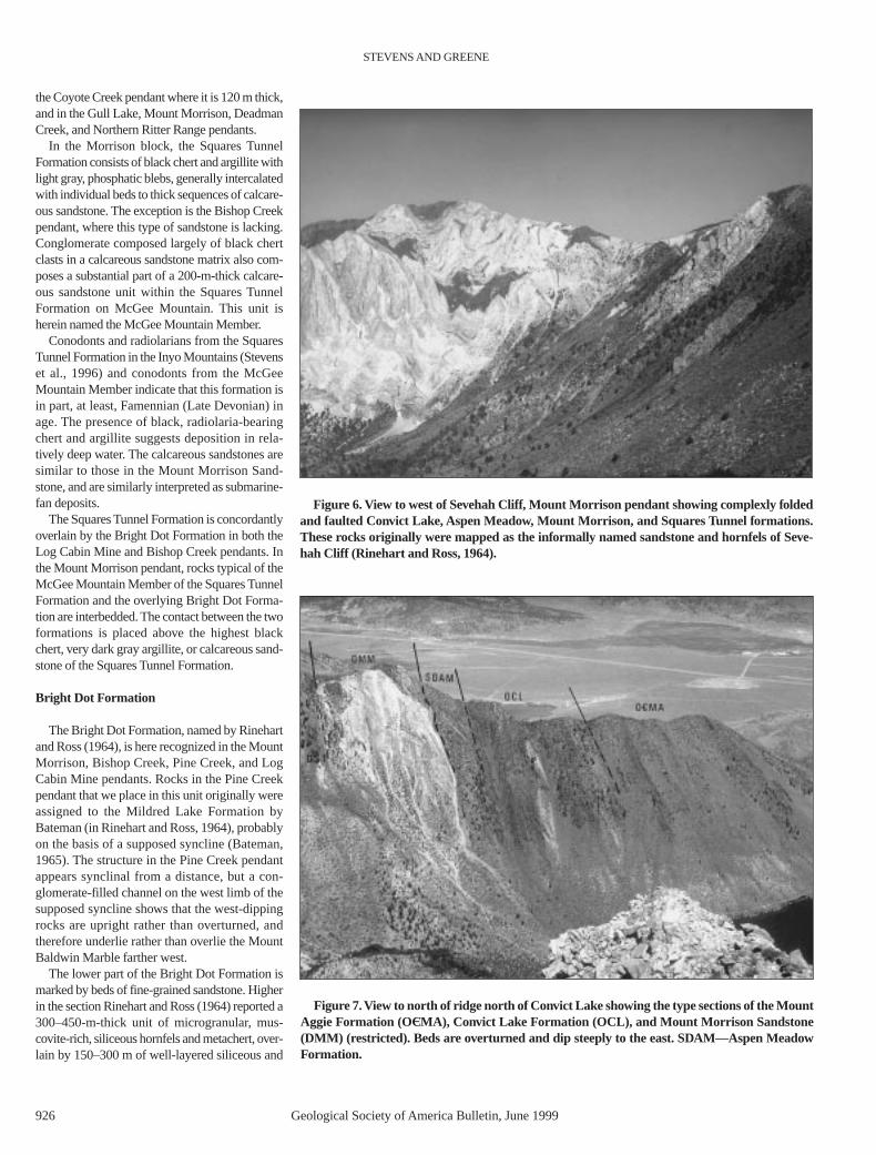
be primarily the result of rapid facies changes, isshown by our work to be the result of structuralrepetition. In several places fragments of variousstratigraphic units have been folded or faulted intowhat Rinehart and Ross (1964) interpreted to benormal stratigraphic sequences (e.g., in SevehahCliff, Fig. 6). At numerous localities, however, in-tact stratigraphic sections are preserved (e.g., theridge north of Convict Lake in the Mount Morri-son pendant, Fig. 7) and provide the frameworkfor unraveling the complex structural relations inmore deformed areas. The stratigraphic columnutilized here is shown in Figure 8.
Mount Aggie Formation
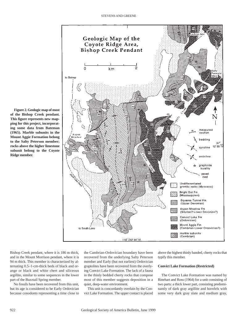
The Mount Aggie Formation, the oldest unitrecognized in the Morrison block, was named byRinehart and Ross (1964). This unit, which hadnot been reported previously beyond the MountMorrison pendant, is now also recognized in theBishop Creek pendant. It is characterized by1500 m or more (Rinehart and Ross, 1964) ofvery dark gray, laminated to thin-bedded,siliceous argillite interbedded with variableamounts of thin-bedded, medium gray, fine-grained limestone, and brown-weathering, verydark gray argillite. The statement of Rinehart andRoss (1964) that the Mount Aggie Formationcontains calcareous quartz sandstone is incorrect.The large exposure of calcareous sandstone inupper McGee Creek in the Mount Morrison pen-dant (Fig. 3), believed by Rinehart and Ross(1964) to belong to the Mount Aggie Formation,for example, actually is an infold of the muchyounger Mount Morrison Sandstone.
In the type section northwest of Convict Lake,the Mount Aggie Formation can be divided intothree informal members. From older to younger,they are the Buzztail Spring member, the SaltyPeterson member, and the Coyote Ridge member.
Buzztail Spring Member
The name Buzztail Spring Formation was pro-posed by Rinehart and Ross (1964) for a highlyfolded and faulted stratigraphic sequence on thenorth side of lower McGee Creek (Fig. 3). We cor-relate these rocks with the lowest unit of the MountAggie Formation exposed at its type section nearConvict Lake and therefore lower the rank of theBuzztail Spring to member and assign it to theMount Aggie Formation. This member has beenidentified only in the Mount Morrison pendant.
On the ridge northwest of Convict Lake, theBuzztail Spring member consists of 600+ m(Wise, 1996) of alternating beds of dark grayargillite, commonly one to a few centimetersthick, and very fine grained, medium bluish-graylimestone, generally a few centimeters thick. In
some parts of the section, limestone may com-pose as much as 30% of the rocks. Conodontsample 13732, collected by Ketner (1998) fromthe upper part of this unit, has yielded conodontsindicating an age close to that of the Cambrian-Ordovician boundary. Because this unit consistsof very fine grained, thin-bedded, dark-coloredargillite and limestone lacking a fauna other thanconodonts, it is interpreted as a moderately deep-water deposit formed far from a sediment source.This unit is conformably overlain by the Salty Pe-terson member. The upper contact is placed be-low the lowest limestone unit in this part of thesection with a minimum thickness of 4 m.
Salty Peterson Member
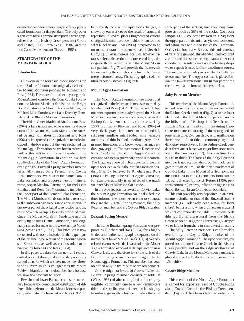
This member of the Mount Aggie Formation,named herein for a prospect in the eastern part ofthe Bishop Creek pendant (Fig. 2), also has beenidentified in the Mount Morrison pendant and inthe hills south of Bishop. It differs from theBuzztail Spring member in containing lime-stone-rich units consisting of alternating beds ofpure limestone, 2–8 cm thick, and argillaceouslimestone, 1–2 cm thick, commonly light anddark gray, respectively. In the Bishop Creek pen-dant there are at least two major limestone unitswithin the member (Fig. 2); the upper limestoneis 110 m thick. The base of the Salty Petersonmember is not exposed there, but its thickness isgreater than 200 m. On the ridge northwest ofConvict Lake in the Mount Morrison pendantthis unit is 34 m thick. Conodonts from sample13762, collected by Keith Ketner (1996, per-sonal commun.) nearby, indicate an age close tothat of the Cambrian-Ordovician boundary.
This unit probably was deposited in an envi-ronment similar to that of the Buzztail Springmember (i.e., relatively deep water, far fromshore), but at a time when argillaceous materialwas not continuously available. Limestone bedsthin rapidly northwestward from the BishopCreek pendant, suggesting increasingly deeperwater farther from shore in a northwest direction.
The Salty Peterson member is conformablyoverlain by the Coyote Ridge member of theMount Aggie Formation. The upper contact, ex-posed both along Coyote Creek in the BishopCreek pendant and on the ridge northwest ofConvict Lake in the Mount Morrison pendant, isplaced above the highest limestone more than1.5 m thick.
Coyote Ridge Member
This member of the Mount Aggie Formationis named for exposures east of Coyote Ridgealong Coyote Creek in the Bishop Creek pen-dant (Fig. 2). It has been identified only in the
STEVENS AND GREENE
922 Geological Society of America Bulletin, June 1999
Bishop Creek pendant, where it is 186 m thick,and in the Mount Morrison pendant, where it is94 m thick. This member is characterized by al-ternating 0.5–1-cm-thick beds of black and or-ange or black and white chert and siliceousargillite, similar to some sequences in the lowerpart of the Buzztail Spring member.
No fossils have been recovered from this unit,but its age is considered to be Early Ordovicianbecause conodonts representing a time close to
the Cambrian-Ordovician boundary have beenrecovered from the underlying Salty Petersonmember and Early (but not earliest) Ordoviciangraptolites have been recovered from the overly-ing Convict Lake Formation. The lack of a faunain the thinly bedded cherty rocks that composemost of this member suggests deposition in aquiet, deep-water environment.
This unit is concordantly overlain by the Con-vict Lake Formation. The upper contact is placed
above the highest thinly banded, cherty rocks thattypify this member.
Convict Lake Formation (Restricted)
The Convict Lake Formation was named byRinehart and Ross (1964) for a unit consisting oftwo parts: a thick lower part, consisting predomi-nantly of dark gray argillite and hornfels withsome very dark gray slate and medium gray,
Figure 2. Geologic map of mostof the Bishop Creek pendant.This figure represents new map-ping for this project, incorporat-ing some data from Bateman(1965). Marble subunits in theMount Aggie Formation belongto the Salty Peterson member;rocks above the higher limestonesubunit belong to the CoyoteRidge member.
PALEOZOIC CONTINENTAL-MARGIN ROCKS, EASTERN SIERRA NEVADA, CALIFORNIA
Geological Society of America Bulletin, June 1999 923
siliceous quartzite, and a much thinner upper part,consisting of light-colored calcareous hornfels.Here, we restrict the name Convict Lake Forma-tion to the thick lower part of the unit as describedby Rinehart and Ross (1964), and reassign the up-per part to the newly named Aspen MeadowFormation because both units are mappable, eas-ily separated and identified, and important for cor-relation within several of the eastern SierraNevada pendants. The Convict Lake Formation,as redefined here, is widely exposed in the Morri-son block, occurring throughout the eastern partof the Mount Morrison pendant and in the BishopCreek, Log Cabin Mine, Northern Ritter Range,and Deadman Pass pendants, as well as near Ar-cularius Ranch.
The Convict Lake Formation as restricted hereconsists primarily of dark gray, commonly rusty-weathering argillite and fine-grained siliceoushornfels with some very dark gray slate and resis-tant ribs of medium- to coarse-grained, mediumto light gray-weathering, noncalcareous quartzite.
Beds of dark gray, cherty argillite with phosphaticlenses and blebs are common near the top of theformation in both the Log Cabin Mine and BishopCreek pendants. The Convict Lake Formation, asrestricted here, is 336 m thick in its type sectionon the ridge north of Convict Lake (Figs. 3 and 7).
Graptolites are well represented in the ConvictLake Formation and all known graptolite locali-ties in the Morrison block are in this unit. Rinehartand Ross (1964) reported graptolites from severalof their map units, but our mapping shows that allof their localities, except locality D, are within theConvict Lake Formation. We believe that localityD was mislocated by Rinehart and Ross (1964)because Upper Devonian conodonts occur atabout the same stratigraphic level. We found onenew graptolite locality in the Mount Morrisonpendant and two new localities yielding probablegraptolites.
Graptolites are most numerous in the BishopCreek pendant. Moore and Foster (1980) re-ported graptolites from two localities, and Frazier
et al. (1986) reported on nine other collections.During the course of this study, we (includingSan Jose State University students) discovered 10additional localities. From the Log Cabin Minependant, one graptolite was reported by Stewart(1985), another locality was discovered duringthe present work with the help of Stan Finney,and probable graptolites were recovered from athird area. Graptolites also were collected fromrocks assigned to the Convict Lake Formationnear Arcularius Ranch (Fig. 1).
Graptolites in the Mount Morrison pendant rep-resent at least zones 6 to 15 (Early to Late Ordovi-cian) of Berry (1960). In the Bishop Creek pen-dant the fossils span graptolite zones 3–7 to at leastzone 14 and probably 15, and rocks from near Ar-cularius Ranch have yielded zone 5 graptolites.The Convict Lake Formation, therefore, representsall except the earliest part of the Ordovician.
The presence of pelagic graptolites, the onlyfossils recovered from the Convict Lake Forma-tion, and the regularly banded, dark-colored,
Figure 3. Geologic map of the Mount Morrison pendant. Figure is based on the map of Rinehart and Ross (1964) with extensive new mappingand reassignment of many rock units. Mapping of Wise (1996) was incorporated in the northeastern part of the area.
argillaceous rocks suggest deposition in ratherdeep, probably oxygen-deficient water. Thequartzites, of which several in the Mount Morri-son pendant appear to be channel-form, probablyfilled channels on a deep-water, sand-poor sub-marine fan.
The Convict Lake Formation is conformablyoverlain by the Aspen Meadow Formation ex-cept on McGee Mountain, where it is uncon-formably overlain by the Mount MorrisonSandstone. The upper contact is placed belowthe lowest sequence of light-colored, thin-bedded, calc-silicate beds of the overlying As-pen Meadow Formation.
Aspen Meadow Formation
The name Aspen Meadow Formation is pro-posed herein for a distinctive 150-m-thick unit ofthinly banded, light-colored calcareous hornfelsand fine-grained, siliceous rocks widely exposedin the Bishop Creek, Mount Morrison, DeadmanPass, Gull Lake, Northern Ritter Range, and LogCabin Mine pendants. The type section on theridge above Aspen Meadow in Bishop CreekCanyon (Fig. 2) consists mostly of very light grayand light green hornfels in bands about 5 and 1 cm thick, respectively (Fig. 9). The type sectionis described in detail in the Data Repository.1
No fossils have been recovered from the As-pen Meadow Formation, but a Silurian to EarlyDevonian age is inferred from the ages of the en-closing rocks. Deposition is interpreted to havebeen in relatively deep, quiet water far from shorebecause the unit is typically very thin bedded,very fine grained, and mostly undisturbed by aninfauna.
The Aspen Meadow Formation is con-formably overlain by the Mount Morrison Sand-stone except in the Bishop Creek pendant, wherethe Mount Morrison Sandstone is not present andthe Aspen Meadow Formation is conformablyoverlain by the Squares Tunnel Formation. In theMcGee Mountain area the Aspen MeadowFormation is missing due to submarine channel-ing prior to deposition of the Mount MorrisonSandstone. The upper contact of the Aspen
Meadow Formation is placed at the base of thelowest calcareous sandstone in the Mount Morri-son Sandstone or black argillite or chert of theSquares Tunnel Formation where the MountMorrison Sandstone is missing.
Sevehah Group
A thick sequence of calcareous quartz sand-stone and sandy limestone complexly interbeddedwith black argillite and chert, commonly contain-ing light gray, phosphatic blebs and lenses, over-lies the Aspen Meadow Formation. This succes-sion is here named the Sevehah Group.
The most distinctive rock type in the SevehahGroup is calcareous quartz sandstone. Such sand-stones in the eastern Sierran roof pendants are re-stricted to this group, so the name Sevehah Groupcan be utilized in areas of incomplete stratigra-phy where calcareous quartz sandstone, not as-signable to a specific formation, crops out. TheSevehah Group consists of two formations: thelower Mount Morrison Sandstone (restricted)
and the upper Squares Tunnel Formation. Thestratigraphic complexities within this unit are il-lustrated in Figure 10.
Mount Morrison Sandstone (Restricted)
The Mount Morrison Sandstone was namedby Rinehart and Ross (1964) for rocks exposedon the summit and east flank of Mount Morrison.The Mount Morrison Sandstone has been recog-nized in the Gull Lake, Deadman Pass, NorthernRitter Range, and Log Cabin Mine pendants, aswell as in the Mount Morrison pendant. It is notrepresented in the Bishop Creek pendant due tonondeposition. A very thin unit exposed nearTinemaha Reservoir at the foot of the InyoMountains (Fig. 1), which consists of conglom-erate essentially identical to that in the MountMorrison Sandstone exposed on McGee Moun-tain, also is assigned to this formation.
The type section of the Mount Morrison Sand-stone originally included a unit of hornfels andmarble almost 100 m thick. Here we consider this
STEVENS AND GREENE
924 Geological Society of America Bulletin, June 1999
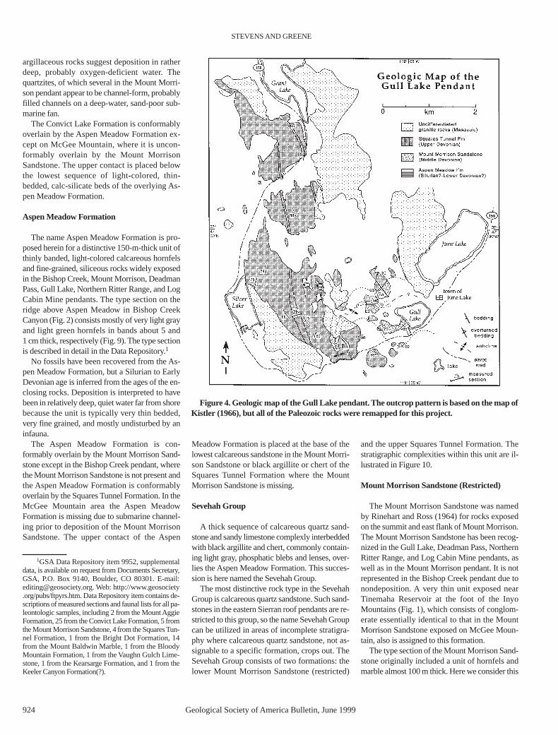
Figure 4. Geologic map of the Gull Lake pendant. The outcrop pattern is based on the map ofKistler (1966), but all of the Paleozoic rocks were remapped for this project.
1GSA Data Repository item 9952, supplementaldata, is available on request from Documents Secretary,GSA, P.O. Box 9140, Boulder, CO 80301. E-mail:[email protected]. Web: http://www.geosociety.org/pubs/ftpyrs.htm. Data Repository item contains de-scriptions of measured sections and faunal lists for all pa-leontologic samples, including 2 from the Mount AggieFormation, 25 from the Convict Lake Formation, 5 fromthe Mount Morrison Sandstone, 4 from the Squares Tun-nel Formation, 1 from the Bright Dot Formation, 14from the Mount Baldwin Marble, 1 from the BloodyMountain Formation, 1 from the Vaughn Gulch Lime-stone, 1 from the Kearsarge Formation, and 1 from theKeeler Canyon Formation(?).
unit and the overlying sandstone and argillite tobe part of the overlying Squares Tunnel Forma-tion. Thus, we restrict the name Mount MorrisonFormation to the lower unbroken succession ofcalcareous quartzite in the type section exposedalong the ridge northwest of Convict Lake. By
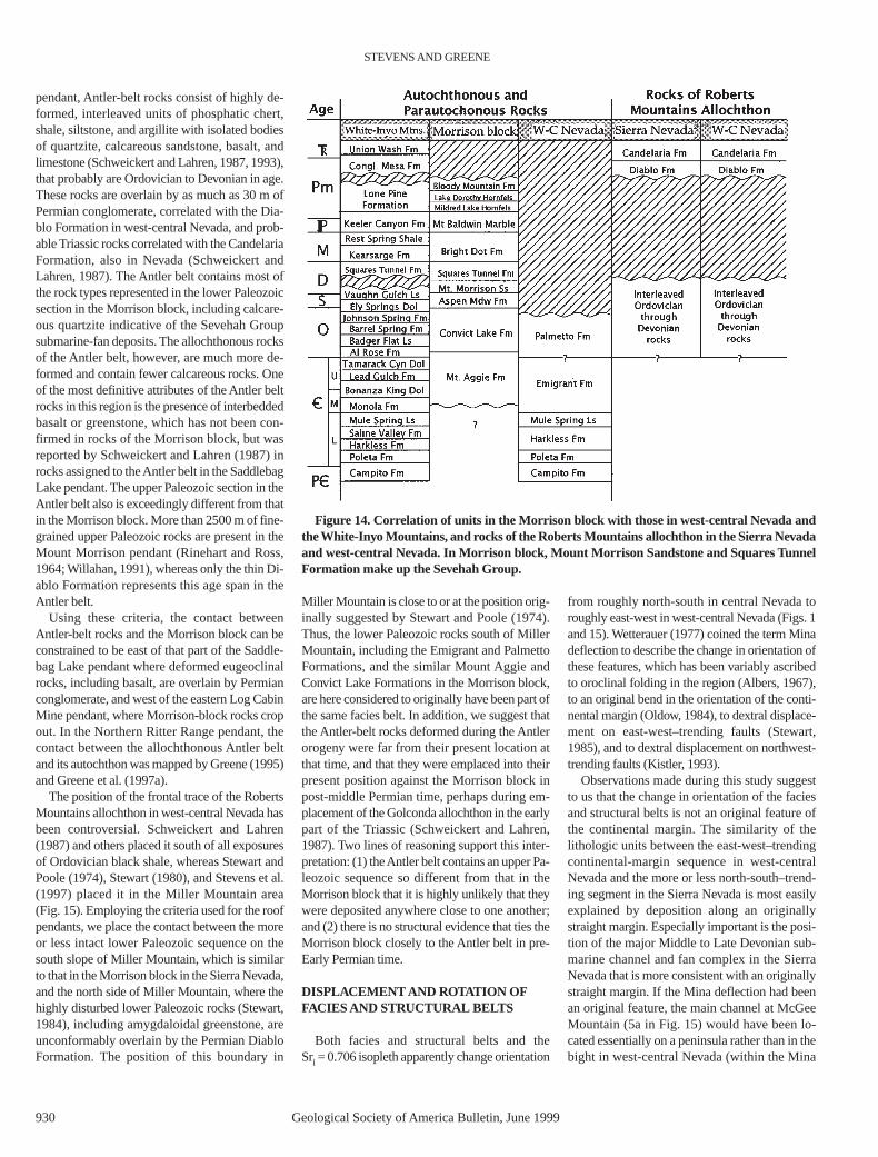
this definition the Mount Morrison Formationconsists of 177 m of fine- to coarse-grained, lightto medium gray, calcareous, bimodal quartzsandstone in beds one to many meters thick.Black chert or argillite clasts, mostly about 0.5cm, but to 25 cm across, commonly are sus-
pended in the sandstone (Fig. 11). Dish structures(Fig. 12) are present in a medium-grained sand-stone at the southwest end of Convict Lake, andsmall- and medium-scale cross-bedding has beenobserved elsewhere.
On McGee Mountain a quite different facies ofMount Morrison Sandstone, 575 m thick, is com-posed of medium- to coarse-grained, calcareoussandstone, containing variable amounts of float-ing lithoclasts (generally dark-colored argillite orchert), and conglomerate with clasts of mediumgray limestone, black chert, rust-weatheringargillite, and light brown or light gray sandstoneand calcareous siltstone as much as 1 m across ina coarse-grained, calcareous, quartz-sandstonematrix (Fig. 13). About one-third of the unit iscomposed of conglomerate. Sandstone lenses to4 m long, probably erosional remnants left by re-peated cut and fill, occur within some of the con-glomerate sequences. Conodonts are rare in theMount Morrison Sandstone. One assemblagefrom a clast in the lower part of the unit at McGeeMountain is Emsian (Early Devonian) in age.Another assemblage from a limestone turbidite atthe top of the Mount Morrison Sandstone nearTinemaha Reservoir is Givetian (late Middle De-vonian) in age, and a third assemblage from sam-ple 13756 collected by Keith Ketner from theConvict Lake area is reported to be Middle De-vonian to early Frasnian (early Late Devonian)(Anita Harris, 1999, personal commun.). Themost likely age of the Mount Morrison Sand-stone, therefore, apparently is Givetian.
Stevens et al. (1995) interpreted the MountMorrison Sandstone as representing a deep-water,submarine-fan system on the basis of the close as-sociation of this unit with black argillite and chertof a deep-water aspect, and sedimentary features,including dish structures, ripple laminations at thetops of some beds, and numerous large chert andargillite clasts floating in sandstone. Each sand-stone bed, typically massive and as thick as sev-eral meters, probably represents a single sedi-ment-gravity flow.
The Mount Morrison Sandstone is con-formably overlain by the Squares Tunnel Forma-tion. The upper contact is placed below the lowestblack chert or argillite unit in the Sevehah group.
Squares Tunnel Formation
The Squares Tunnel Formation was named byStevens et al. (1996) for Upper Devonian rocks inthe western Inyo Mountains near Independence(Fig. 1). At the type locality the Squares TunnelFormation is composed of dark gray to blackargillite and chert commonly with light gray phos-phatic blebs or stringers 2 to 8 mm thick and 2 to6 cm long. This unit is now recognized in the LogCabin Mine pendant where it is 280 m thick, in
PALEOZOIC CONTINENTAL-MARGIN ROCKS, EASTERN SIERRA NEVADA, CALIFORNIA
Geological Society of America Bulletin, June 1999 925
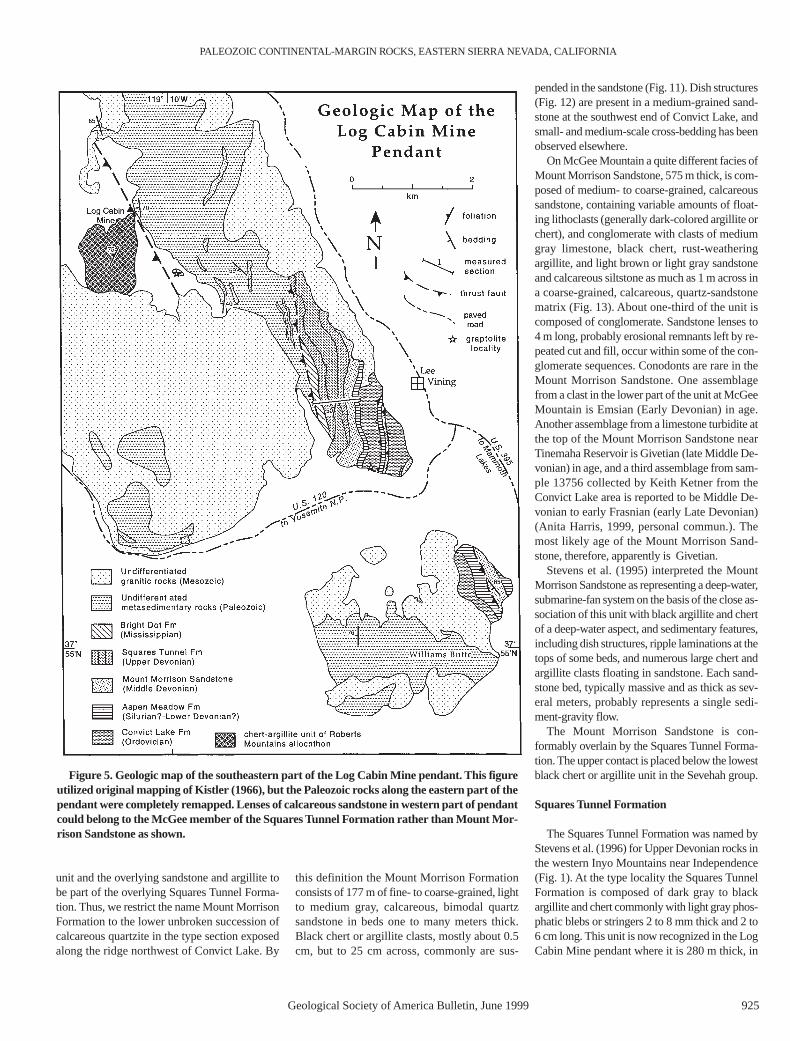
Figure 5. Geologic map of the southeastern part of the Log Cabin Mine pendant. This figureutilized original mapping of Kistler (1966), but the Paleozoic rocks along the eastern part of thependant were completely remapped. Lenses of calcareous sandstone in western part of pendantcould belong to the McGee member of the Squares Tunnel Formation rather than Mount Mor-rison Sandstone as shown.
the Coyote Creek pendant where it is 120 m thick,and in the Gull Lake, Mount Morrison, DeadmanCreek, and Northern Ritter Range pendants.
In the Morrison block, the Squares TunnelFormation consists of black chert and argillite withlight gray, phosphatic blebs, generally intercalatedwith individual beds to thick sequences of calcare-ous sandstone. The exception is the Bishop Creekpendant, where this type of sandstone is lacking.Conglomerate composed largely of black chertclasts in a calcareous sandstone matrix also com-poses a substantial part of a 200-m-thick calcare-ous sandstone unit within the Squares TunnelFormation on McGee Mountain. This unit isherein named the McGee Mountain Member.
Conodonts and radiolarians from the SquaresTunnel Formation in the Inyo Mountains (Stevenset al., 1996) and conodonts from the McGeeMountain Member indicate that this formation isin part, at least, Famennian (Late Devonian) inage. The presence of black, radiolaria-bearingchert and argillite suggests deposition in rela-tively deep water. The calcareous sandstones aresimilar to those in the Mount Morrison Sand-stone, and are similarly interpreted as submarine-fan deposits.
The Squares Tunnel Formation is concordantlyoverlain by the Bright Dot Formation in both theLog Cabin Mine and Bishop Creek pendants. Inthe Mount Morrison pendant, rocks typical of theMcGee Mountain Member of the Squares TunnelFormation and the overlying Bright Dot Forma-tion are interbedded. The contact between the twoformations is placed above the highest blackchert, very dark gray argillite, or calcareous sand-stone of the Squares Tunnel Formation.
Bright Dot Formation
The Bright Dot Formation, named by Rinehartand Ross (1964), is here recognized in the MountMorrison, Bishop Creek, Pine Creek, and LogCabin Mine pendants. Rocks in the Pine Creekpendant that we place in this unit originally wereassigned to the Mildred Lake Formation byBateman (in Rinehart and Ross, 1964), probablyon the basis of a supposed syncline (Bateman,1965). The structure in the Pine Creek pendantappears synclinal from a distance, but a con-glomerate-filled channel on the west limb of thesupposed syncline shows that the west-dippingrocks are upright rather than overturned, andtherefore underlie rather than overlie the MountBaldwin Marble farther west.
The lower part of the Bright Dot Formation ismarked by beds of fine-grained sandstone. Higherin the section Rinehart and Ross (1964) reported a300–450-m-thick unit of microgranular, mus-covite-rich, siliceous hornfels and metachert, over-lain by 150–300 m of well-layered siliceous and
STEVENS AND GREENE
926 Geological Society of America Bulletin, June 1999
Figure 6. View to west of Sevehah Cliff, Mount Morrison pendant showing complexly foldedand faulted Convict Lake, Aspen Meadow, Mount Morrison, and Squares Tunnel formations.These rocks originally were mapped as the informally named sandstone and hornfels of Seve-hah Cliff (Rinehart and Ross, 1964).
Figure 7. View to north of ridge north of Convict Lake showing the type sections of the MountAggie Formation (OC–MA), Convict Lake Formation (OCL), and Mount Morrison Sandstone(DMM) (restricted). Beds are overturned and dip steeply to the east. SDAM—Aspen MeadowFormation.
calcareous hornfels in layers 1 cm to 1 m thick.Several calcareous lenses associated with chert-and limestone-pebble conglomerate (Willahan,1991) in the upper part of the formation haveyielded a largely reworked conodont fauna includ-ing Lower, Middle, and Upper Devonian andLower and Upper Mississippian forms (Willahan,1991). In the Bishop Creek pendant there are sev-eral beds of fine-grained conglomerate composedlargely of black chert clasts. The Bright DotFormation probably is entirely Mississippian inage as it is underlain by Upper Devonian and over-lain by Lower Pennsylvanian rocks.
The nature of the depositional environment ofthe Bright Dot Formation is obscure. Sedimentarystructures other than parallel laminae and smallscours in sandstone at the base of the section havenot been noted. Fossil-bearing, debris-flow de-posits near the top of the section in the MountMorrison pendant suggest deposition in a marineenvironment near the base of a moderately steepslope, and a conglomerate-filled channel in thePine Creek pendant may have formed subaerially.Because the underlying Squares Tunnel Forma-tion is interpreted as a relatively deep-water de-posit, and the overlying Mount Baldwin Marble is
a shallow-water, carbonate-bank accumulation,the Bright Dot Formation probably represents ashallowing-upward sequence.
The Bright Dot Formation appears to be over-lain concordantly by the Mount Baldwin Marble,although Wise (1996) stated that the contact isunconformable. The upper contact is placed atthe base of the lowest limestone in the MountBaldwin Marble.
Mount Baldwin Marble
This formation was named by Rinehart andRoss (1964) for a 189-m-thick section of marble(Willahan, 1991) in the Mount Morrison pen-dant; Bateman (in Rinehart and Ross, 1964) cor-related a similar marble unit in the Pine Creekpendant with it. Rocks here assigned to theMount Baldwin Marble, in addition to the locali-ties mentioned in Rinehart and Ross (1964), in-clude outcrops near the mouth of McGee Creek,named Hilton Creek Marble by Rinehart andRoss (1964); banded, very coarse-grained marbleon Chocolate Peak; fossiliferous lenses of alteredlimestone trapped along the Gem Lake shearzone in the Northern Ritter Range pendant
(Greene and Schweickert, 1995); and a largelimestone mass near Conway Summit (Fig. 1).
The Mount Baldwin Marble consists of almostpure, medium to dark gray to bluish-gray, fine-grained to very coarse grained marble. Blackchert in nodules or nodular beds is locally abun-dant in the lower part of the formation.
Fossils reported by Rinehart and Ross (1964),including crinoidal debris, corals, and brachio-pods, were interpreted by them to be Early Penn-sylvanian in age. Willahan (1991) recovered Mor-rowan (Early Pennsylvanian) conodonts from twosamples near the base of the formation, and dur-ing this study, two additional samples from nearthe type locality yielded identifiable conodonts.One sample from the middle of the formation islate Atokan–early Desmoinesian (Middle Penn-sylvanian) in age, and the other, collected from theuppermost 2 m of the formation, yielded an As-selian (early Early Permian) fauna. Thus, theMount Baldwin Marble spans earliest Pennsyl-vanian to earliest Permian time. The fauna, con-sisting of a variety of shallow-water calcareousfossils, and the rocks, composed of thick-bedded,pure limestone, suggest deposition on a shallow-water, carbonate bank. The contact between theMount Baldwin Marble and the overlying Mil-dred Lake Hornfels is sharp but conformable.
Post-earliest Permian Formations
Rinehart and Ross (1964) divided the post-earliest Permian section in the Mount Morrisonpendant, the top of which is not exposed, intothree formations; from older to younger, theseare the Mildred Lake Hornfels, the LakeDorothy Hornfels, and the Bloody MountainFormation. These units, which were describedby Rinehart and Ross (1964) and Willahan(1991), consist primarily of fine-grainedsiliceous hornfels that locally are interbeddedwith coarse-grained debris-flow deposits bear-ing rare shallow-marine fossils. These rockssuggest a depositional environment at or nearthe base of a submarine slope.
REGIONAL CORRELATIONS AND INTERPRETATIONS
Rocks temporally correlative with those of theMorrison block are exposed to the east in west-central Nevada and the White-Inyo Range, and tothe west in the Saddlebag Lake, western LogCabin Mine, and Northern Ritter Range pendants(Fig. 1). Previously, with minimal dating of poorlyunderstood stratigraphic units and differences infacies, relationships between the Paleozoic rocksof the Morrison block and those in these other ar-eas were unclear. Now that the stratigraphy of theMorrison block has been clarified and most units
PALEOZOIC CONTINENTAL-MARGIN ROCKS, EASTERN SIERRA NEVADA, CALIFORNIA
Geological Society of America Bulletin, June 1999 927
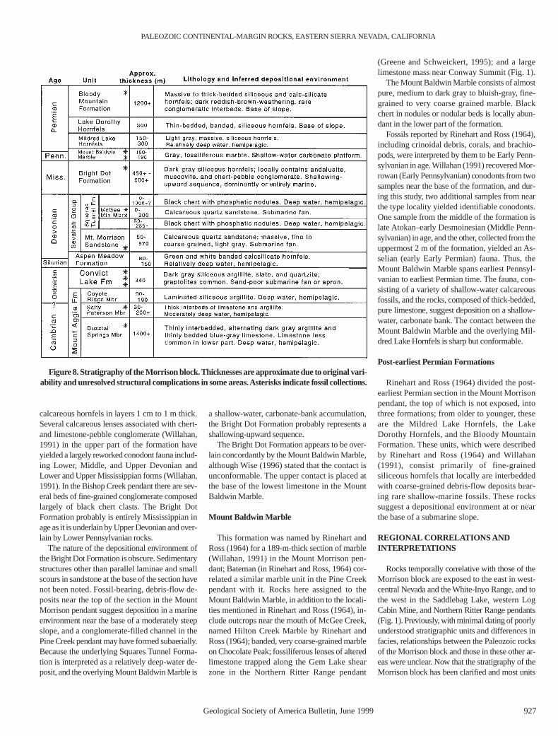
Figure 8. Stratigraphy of the Morrison block. Thicknesses are approximate due to original vari-ability and unresolved structural complications in some areas. Asterisks indicate fossil collections.
have been relatively well dated, the paleogeo-graphic significance of the various lithofacies canbe interpreted with confidence.
The oldest unit in the Morrison block, theMount Aggie Formation, correlates lithologi-cally and temporally with the Emigrant Forma-tion in west-central Nevada and rocks mapped asEmigrant Formation by Nelson (1966) in theWhite Mountains (Fig. 14). The upper part of theMount Aggie Formation has yielded conodontssuggesting an age close to that of the Cambrian-Ordovician boundary and the Emigrant Forma-tion has been dated as Middle to Late Cambrian(Albers and Stewart, 1972). The age of the topsof these two formations is very similar; grapto-lite-bearing rocks immediately overlying theMount Aggie and Emigrant Formations repre-sent graptolite zones 4 or 5 and zones 3–8, re-spectively, according to William Berry (1996,personal commun.). The fine-grained, thin-bed-ded Mount Aggie and Emigrant Formations,which contrast greatly with the shallow-waterdolomite, limestone, and shale (Monola Forma-tion through Tamarack Canyon Dolomite) thataccumulated concurrently in the White-InyoRange, define an important facies boundary thatrepresents the Middle to Upper Cambrian shelfmargin of western North America (Fig. 15).
The highest member of the Mount AggieFormation, the siliceous, thin-bedded CoyoteRidge member, is similar lithologically to thelower part of the Lower Ordovician Al Rose For-mation in the western Inyo Mountains belowbeds that have yielded zone 4–6 graptolites(Ross, 1966). The Coyote Ridge member occursbelow graptolite zone 4 or 5, so it may correlatetemporally, as well as lithologically, with beds ofthe lower Al Rose Formation.
The deep-water Convict Lake Formation in theMorrison block and the lithologically similar Pal-metto Formation in west-central Nevada haveyielded graptolites representing at least zone 5 to15 (within the Lower Ordovician to very high inthe Ordovician rocks) and zones 3–8 to zone 14,respectively (William Berry, 1996, personal com-mun.). Thus, both units are of essentially identi-cal age. Coeval units in the western Inyo Moun-tains were deposited primarily in shallow water.The upper part of the Al Rose Formation, whichhas yielded zone 4–6 graptolites, and the BarrelSpring Formation, which contains zone 12 grap-tolites (William Berry, 1996, personal commun.),are coeval with the lower and middle parts of theConvict Lake and Palmetto Formations. TheMiddle Ordovician Johnson Spring Formation, aEureka Quartzite equivalent in the western InyoMountains (Ross, 1966), and the lower, Late Or-dovician part of the Ely Springs Dolomite(Miller, 1975) correlate with the upper parts ofthe Convict Lake and Palmetto Formations. Dep-
osition of both the Convict Lake and PalmettoFormations was characterized by slow accumula-tion of clay and silica occasionally interrupted bythe influx of almost pure quartz sand. This sandalmost surely represents the distal edge of the Eu-reka sand sheet that spread over the miogeoclineas far west as the western Inyo Mountains(Stevens, 1986, 1991).
The Convict Lake Formation is overlain by thedeep-water Aspen Meadow Formation, which
represents part or all of the Silurian–LowerDevonian interval. This and younger Paleozoicunits of the Morrison block have no temporalequivalents in either the parautochthonous rocksof west-central Nevada or the White Mountainsbecause of post-Paleozoic erosion. In the westernInyo Mountains temporally equivalent units in-clude the upper part of the shallow-water ElySprings Dolomite, the overlying Vaughn GulchLimestone, which contains transported reefal de-
STEVENS AND GREENE
928 Geological Society of America Bulletin, June 1999
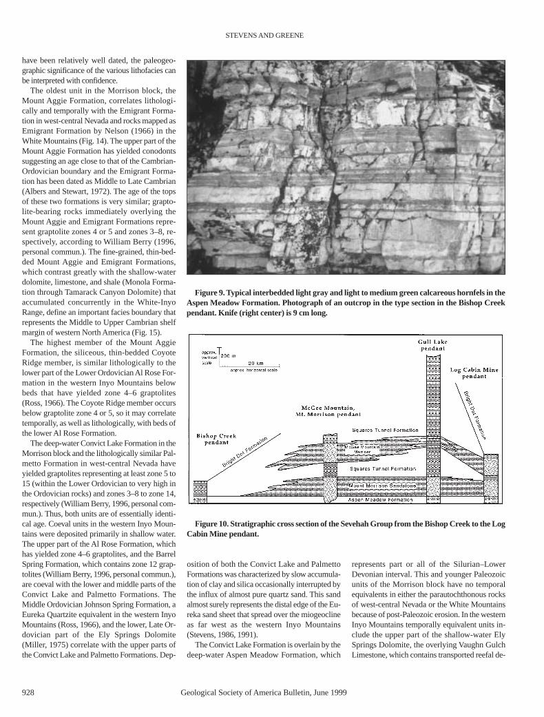
Figure 9. Typical interbedded light gray and light to medium green calcareous hornfels in theAspen Meadow Formation. Photograph of an outcrop in the type section in the Bishop Creekpendant. Knife (right center) is 9 cm long.
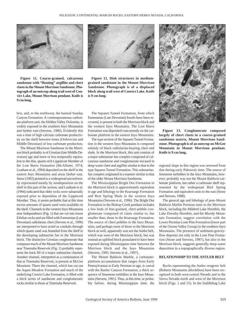
Figure 10. Stratigraphic cross section of the Sevehah Group from the Bishop Creek to the LogCabin Mine pendant.
bris, and, to the northwest, the basinal SundayCanyon Formation. A contemporaneous carbon-ate-platform unit, the Hidden Valley Dolomite, iswidely exposed in the southern Inyo Mountainsand farther east (Stevens, 1986). Evidently thiswas a time of high calcium carbonate productiv-ity on the shelf between times (Ordovician andMiddle Devonian) of less carbonate production.
The Mount Morrison Sandstone in the Morri-son block probably is of Givetian (late Middle De-vonian) age and more or less temporally equiva-lent to the thin, quartz-rich Lippincott Member ofthe Lost Burro Formation (McAllister, 1974;Leatham et al., 1994) deposited on the shelf in theeastern Inyo Mountains and areas farther east.Snow (1992) pointed to a widespread unconform-ity represented mostly by nondeposition on theshelf in this part of the section, and Leatham et al.(1994) indicated that older rocks were subaeriallyexposed prior to deposition of the LippincottMember. Thus, it seems probable that at this timeexcess amounts of quartz sand were available onthe shelf. Channels in the western Inyo Mountainsnear Independence (Fig. 1) that are cut into lowerEifelian rocks and are filled with Famennian (LateDevonian) radiolarian chert (Stevens et al., 1996)are interpreted to have acted as conduits throughwhich quartz sand was funneled from the shelf tothe developing submarine fan in the Morrisonblock. The distinctive Givetian conglomerate thatcomposes much of the Mount Morrison Sandstonenear Tinemaha Reservoir (Fig. 1) probably repre-sents the back fill of a major submarine channel.Another channel, interpreted as a continuation ofthat at Tinemaha Reservoir, is present at McGeeMountain. There the channel, which has cut outthe Aspen Meadow Formation and much of theunderlying Convict Lake Formation, is filled witha thick series of sandstone and conglomeraticrocks similar to those at Tinemaha Reservoir.
The Squares Tunnel Formation, from whichFamennian (Late Devonian) fossils have been re-covered, is present in both the Morrison block andthe western Inyo Mountains. The Lost BurroFormation was deposited concurrently on the car-bonate platform in the eastern Inyo Mountains.
The type section of the Squares Tunnel Forma-tion in the western Inyo Mountains is composedentirely of black radiolarian-bearing chert andshale. In the Morrison block, this unit consists ofa major submarine-fan complex composed of cal-careous sandstone and conglomerate encased indeep-water chert and argillite similar to that in thetype Squares Tunnel Formation. This submarine-fan complex originated in a manner similar to thatof the older Mount Morrison Sandstone.
The Mississippian Bright Dot Formation inthe Morrison block is approximately equivalentin age and lithology to the Kearsarge Formationand Rest Spring Shale in the western InyoMountains (Stevens et al., 1996). The Bright DotFormation in the Bishop Creek pendant includesa few beds of fine-grained, chert-pebble con-glomerate composed of clasts similar to, butsmaller than, those in the Kearsarge Formation.The source of chert pebbles in the Inyo Moun-tains, and perhaps most of those in the Morrisonblock as well, apparently was not the Antler belt,which was west of the Morrison block, but wasinstead an uplifted block postulated to have beenexposed during Mississippian time between theMorrison block and the Inyo Mountains(Stevens, 1995; Stevens et al., 1997).
The Mount Baldwin Marble, a carbonate-platform accumulation that ranges from EarlyPennsylvanian to Early Permian in age, is coevalwith the Keeler Canyon Formation, a thick se-quence of limestone turbidites in the Inyo Moun-tains (Stevens, 1991). Thus, at this time, or proba-bly before, during Mississippian time, the
regional slope in this region was reversed fromthat during early Paleozoic time. The source oflimestone turbidites in the Inyo Mountains, how-ever, probably was not the Mount Baldwin car-bonate platform, but rather a carbonate shelf rep-resented by the widespread Bird SpringFormation and equivalent units to the east (Stoneand Stevens, 1988).
The general age and lithology of post–MountBaldwin Marble Permian units in the Morrisonblock, including the Mildred Lake Hornfels, theLake Dorothy Hornfels, and the Bloody Moun-tain Formation, suggest correlation with theLower Permian Lone Pine Formation (lower partof the Owens Valley Group) in the southern InyoMountains. The presence of sediment-gravity-flow deposits not only in the Lone Pine Forma-tion (Stone and Stevens, 1987), but also in theMorrison block, suggests generally deep-waterdeposition in a topographically diverse region.
RELATIONSHIP TO THE ANTLER BELT
Rocks representing the Antler orogenic belt(Roberts Mountains allochthon) have been rec-ognized in both west-central Nevada and in theSierra Nevada north and west of the Morrisonblock (Figs. 1 and 15). In the Saddlebag Lake
PALEOZOIC CONTINENTAL-MARGIN ROCKS, EASTERN SIERRA NEVADA, CALIFORNIA
Geological Society of America Bulletin, June 1999 929
Figure 11. Coarse-grained, calcareoussandstone with “floating” argillite and chertclasts in the Mount Morrison Sandstone. Pho-tograph of an outcrop along trail west of Con-vict Lake, Mount Morrison pendant. Knife is9 cm long.
Figure 12. Dish structures in medium-grained sandstone in the Mount MorrisonSandstone. Photograph is of a displacedblock along trail west of Convict Lake. Knifeis 9 cm long.
Figure 13. Conglomerate composedlargely of chert clasts in a coarse-grainedsandstone matrix, Mount Morrison Sand-stone. Photograph is of an outcrop on McGeeMountain in Mount Morrison pendant.Knife is 9 cm long.
pendant, Antler-belt rocks consist of highly de-formed, interleaved units of phosphatic chert,shale, siltstone, and argillite with isolated bodiesof quartzite, calcareous sandstone, basalt, andlimestone (Schweickert and Lahren, 1987, 1993),that probably are Ordovician to Devonian in age.These rocks are overlain by as much as 30 m ofPermian conglomerate, correlated with the Dia-blo Formation in west-central Nevada, and prob-able Triassic rocks correlated with the CandelariaFormation, also in Nevada (Schweickert andLahren, 1987). The Antler belt contains most ofthe rock types represented in the lower Paleozoicsection in the Morrison block, including calcare-ous quartzite indicative of the Sevehah Groupsubmarine-fan deposits. The allochthonous rocksof the Antler belt, however, are much more de-formed and contain fewer calcareous rocks. Oneof the most definitive attributes of the Antler beltrocks in this region is the presence of interbeddedbasalt or greenstone, which has not been con-firmed in rocks of the Morrison block, but wasreported by Schweickert and Lahren (1987) inrocks assigned to the Antler belt in the SaddlebagLake pendant. The upper Paleozoic section in theAntler belt also is exceedingly different from thatin the Morrison block. More than 2500 m of fine-grained upper Paleozoic rocks are present in theMount Morrison pendant (Rinehart and Ross,1964; Willahan, 1991), whereas only the thin Di-ablo Formation represents this age span in theAntler belt.
Using these criteria, the contact betweenAntler-belt rocks and the Morrison block can beconstrained to be east of that part of the Saddle-bag Lake pendant where deformed eugeoclinalrocks, including basalt, are overlain by Permianconglomerate, and west of the eastern Log CabinMine pendant, where Morrison-block rocks cropout. In the Northern Ritter Range pendant, thecontact between the allochthonous Antler beltand its autochthon was mapped by Greene (1995)and Greene et al. (1997a).
The position of the frontal trace of the RobertsMountains allochthon in west-central Nevada hasbeen controversial. Schweickert and Lahren(1987) and others placed it south of all exposuresof Ordovician black shale, whereas Stewart andPoole (1974), Stewart (1980), and Stevens et al.(1997) placed it in the Miller Mountain area(Fig. 15). Employing the criteria used for the roofpendants, we place the contact between the moreor less intact lower Paleozoic sequence on thesouth slope of Miller Mountain, which is similarto that in the Morrison block in the Sierra Nevada,and the north side of Miller Mountain, where thehighly disturbed lower Paleozoic rocks (Stewart,1984), including amygdaloidal greenstone, areunconformably overlain by the Permian DiabloFormation. The position of this boundary in
Miller Mountain is close to or at the position orig-inally suggested by Stewart and Poole (1974).Thus, the lower Paleozoic rocks south of MillerMountain, including the Emigrant and PalmettoFormations, and the similar Mount Aggie andConvict Lake Formations in the Morrison block,are here considered to originally have been part ofthe same facies belt. In addition, we suggest thatthe Antler-belt rocks deformed during the Antlerorogeny were far from their present location atthat time, and that they were emplaced into theirpresent position against the Morrison block inpost-middle Permian time, perhaps during em-placement of the Golconda allochthon in the earlypart of the Triassic (Schweickert and Lahren,1987). Two lines of reasoning support this inter-pretation: (1) the Antler belt contains an upper Pa-leozoic sequence so different from that in theMorrison block that it is highly unlikely that theywere deposited anywhere close to one another;and (2) there is no structural evidence that ties theMorrison block closely to the Antler belt in pre-Early Permian time.
DISPLACEMENT AND ROTATION OFFACIES AND STRUCTURAL BELTS
Both facies and structural belts and the Sri = 0.706 isopleth apparently change orientation
from roughly north-south in central Nevada toroughly east-west in west-central Nevada (Figs. 1and 15). Wetterauer (1977) coined the term Minadeflection to describe the change in orientation ofthese features, which has been variably ascribedto oroclinal folding in the region (Albers, 1967),to an original bend in the orientation of the conti-nental margin (Oldow, 1984), to dextral displace-ment on east-west–trending faults (Stewart,1985), and to dextral displacement on northwest-trending faults (Kistler, 1993).
Observations made during this study suggestto us that the change in orientation of the faciesand structural belts is not an original feature ofthe continental margin. The similarity of thelithologic units between the east-west–trendingcontinental-margin sequence in west-centralNevada and the more or less north-south–trend-ing segment in the Sierra Nevada is most easilyexplained by deposition along an originallystraight margin. Especially important is the posi-tion of the major Middle to Late Devonian sub-marine channel and fan complex in the SierraNevada that is more consistent with an originallystraight margin. If the Mina deflection had beenan original feature, the main channel at McGeeMountain (5a in Fig. 15) would have been lo-cated essentially on a peninsula rather than in thebight in west-central Nevada (within the Mina
STEVENS AND GREENE
930 Geological Society of America Bulletin, June 1999
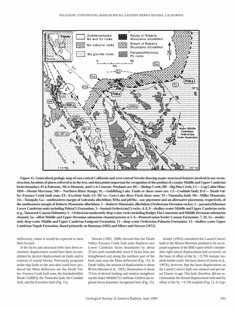
Figure 14. Correlation of units in the Morrison block with those in west-central Nevada andthe White-Inyo Mountains, and rocks of the Roberts Mountains allochthon in the Sierra Nevadaand west-central Nevada. In Morrison block, Mount Morrison Sandstone and Squares TunnelFormation make up the Sevehah Group.
PALEOZOIC CONTINENTAL-MARGIN ROCKS, EASTERN SIERRA NEVADA, CALIFORNIA
Geological Society of America Bulletin, June 1999 931
deflection), where it would be expected to havebeen located.
If the facies and structural belts have been re-oriented, displacement would have been accom-plished by dextral displacement on faults and/orrotation of crustal blocks. Previously proposedstrike-slip faults in the area that could have pro-duced the Mina deflection are the Death Val-ley–Furnace Creek fault zone, the IntrabatholithicBreak 3 (IBB3), the Tinemaha fault, the Coaldalefault, and the Excelsior fault (Fig. 15).
Stewart (1985, 1988) showed that the DeathValley–Furnace Creek fault zone displaces twoLower Cambrian facies boundaries by about 35 km (and considerably more if facies lines arestraightened out) along the northern part of thefault zone near the Mina deflection (Fig. 15). InDeath Valley, the amount of displacement is about80 km (Stevens et al., 1991). Restoration of about70 km of dextral faulting and rotation straightensout the major Middle(?) Cambrian–Ordovician re-gional facies boundary recognized here (Fig. 15).
Kistler (1993) considered the Laurel-Convictfault in the Mount Morrison pendant to be an ex-posed segment of the IBB3 upon which consider-able right-lateral displacement had occurred, onthe basis of offset of the Sri = 0.706 isotopic iso-pleth farther north. We have shown (Greene et al.,1997b), however, that the latest displacement onthe Laurel-Convict fault was sinistral and pre-lat-est Triassic in age. This fault, therefore, did not ac-commodate the dextral displacement indicated byoffset of the Sri = 0.706 isopleth (Fig. 1). A cryp-
Figure 15. Generalized geologic map of east-central California and west-central Nevada showing major structural features involved in our recon-struction, locations of places referred to in the text, and data points important for recognition of the position of a major Middle and Upper Cambrianfacies boundary. Pz is Paleozoic, Mz is Mesozoic, and Cz is Cenozoic. Pendants are: BC—Bishop Creek; BP—Big Pine Creek; LC—Log Cabin Mine;MM—Mount Morrison; NR— Northern Ritter Range; SL—Saddlebag Lake. Faults or shear zones are: Cf—Coaldale fault; D-F— Death Val-ley–Furnace Creek fault zone; Ef—Excelsior fault; GL-RF sz—Gem Lake–Rosy Finch shear zone; Tf—Tinemaha fault. Mi—Miller Mountain;Tn—Tonopah; Ga—southeastern margin of Golconda allochthon; RMa and pRMa—our placement and an alternative placement, respectively, ofthe southeastern margin of Roberts Mountains allochthon. 1—Roberts Mountains allochthon (Ordovician-Devonian rocks); 2—parautochthonousLower Cambrian units including Poleta(?) Formation; 3—basinal Ordovician(?) rocks; 4, 8, 9—shallow-water Middle and Upper Cambrian rocks(e.g.,Tamarack Canyon Dolomite); 5—Ordovician moderately deep-water rocks including Badger Flat Limestone and Middle Devonian submarinechannel; 5a—offset Middle and Upper Devonian submarine channel present at 5. 6—Pennsylvanian Keeler Canyon Formation; 7, 10, 12—moder-ately deep-water Middle and Upper Cambrian Emigrant Formation; 11—deep-water Ordovician Palmetto Formation; 13—shallow-water UpperCambrian Nopah Formation. Based primarily on Bateman (1992) and Albers and Stewart (1972).
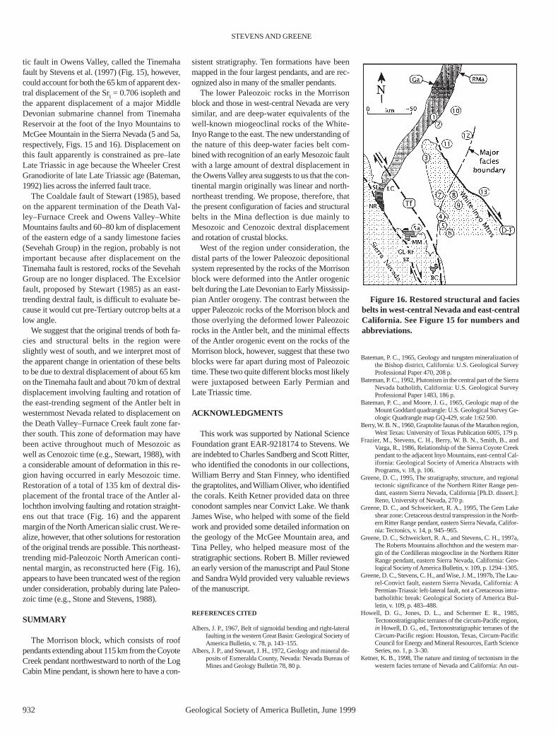
tic fault in Owens Valley, called the Tinemahafault by Stevens et al. (1997) (Fig. 15), however,could account for both the 65 km of apparent dex-tral displacement of the Sri = 0.706 isopleth andthe apparent displacement of a major MiddleDevonian submarine channel from TinemahaReservoir at the foot of the Inyo Mountains toMcGee Mountain in the Sierra Nevada (5 and 5a,respectively, Figs. 15 and 16). Displacement onthis fault apparently is constrained as pre–lateLate Triassic in age because the Wheeler CrestGranodiorite of late Late Triassic age (Bateman,1992) lies across the inferred fault trace.
The Coaldale fault of Stewart (1985), basedon the apparent termination of the Death Val-ley–Furnace Creek and Owens Valley–WhiteMountains faults and 60–80 km of displacementof the eastern edge of a sandy limestone facies(Sevehah Group) in the region, probably is notimportant because after displacement on theTinemaha fault is restored, rocks of the SevehahGroup are no longer displaced. The Excelsiorfault, proposed by Stewart (1985) as an east-trending dextral fault, is difficult to evaluate be-cause it would cut pre-Tertiary outcrop belts at alow angle.
We suggest that the original trends of both fa-cies and structural belts in the region wereslightly west of south, and we interpret most ofthe apparent change in orientation of these beltsto be due to dextral displacement of about 65 kmon the Tinemaha fault and about 70 km of dextraldisplacement involving faulting and rotation ofthe east-trending segment of the Antler belt inwesternmost Nevada related to displacement onthe Death Valley–Furnace Creek fault zone far-ther south. This zone of deformation may havebeen active throughout much of Mesozoic aswell as Cenozoic time (e.g., Stewart, 1988), witha considerable amount of deformation in this re-gion having occurred in early Mesozoic time.Restoration of a total of 135 km of dextral dis-placement of the frontal trace of the Antler al-lochthon involving faulting and rotation straight-ens out that trace (Fig. 16) and the apparentmargin of the North American sialic crust. We re-alize, however, that other solutions for restorationof the original trends are possible. This northeast-trending mid-Paleozoic North American conti-nental margin, as reconstructed here (Fig. 16),appears to have been truncated west of the regionunder consideration, probably during late Paleo-zoic time (e.g., Stone and Stevens, 1988).
SUMMARY
The Morrison block, which consists of roofpendants extending about 115 km from the CoyoteCreek pendant northwestward to north of the LogCabin Mine pendant, is shown here to have a con-
sistent stratigraphy. Ten formations have beenmapped in the four largest pendants, and are rec-ognized also in many of the smaller pendants.
The lower Paleozoic rocks in the Morrisonblock and those in west-central Nevada are verysimilar, and are deep-water equivalents of thewell-known miogeoclinal rocks of the White-Inyo Range to the east. The new understanding ofthe nature of this deep-water facies belt com-bined with recognition of an early Mesozoic faultwith a large amount of dextral displacement inthe Owens Valley area suggests to us that the con-tinental margin originally was linear and north-northeast trending. We propose, therefore, thatthe present configuration of facies and structuralbelts in the Mina deflection is due mainly toMesozoic and Cenozoic dextral displacementand rotation of crustal blocks.
West of the region under consideration, thedistal parts of the lower Paleozoic depositionalsystem represented by the rocks of the Morrisonblock were deformed into the Antler orogenicbelt during the Late Devonian to Early Mississip-pian Antler orogeny. The contrast between theupper Paleozoic rocks of the Morrison block andthose overlying the deformed lower Paleozoicrocks in the Antler belt, and the minimal effectsof the Antler orogenic event on the rocks of theMorrison block, however, suggest that these twoblocks were far apart during most of Paleozoictime. These two quite different blocks most likelywere juxtaposed between Early Permian andLate Triassic time.
ACKNOWLEDGMENTS
This work was supported by National ScienceFoundation grant EAR-9218174 to Stevens. Weare indebted to Charles Sandberg and Scott Ritter,who identified the conodonts in our collections,William Berry and Stan Finney, who identifiedthe graptolites, and William Oliver, who identifiedthe corals. Keith Ketner provided data on threeconodont samples near Convict Lake. We thankJames Wise, who helped with some of the fieldwork and provided some detailed information onthe geology of the McGee Mountain area, andTina Pelley, who helped measure most of thestratigraphic sections. Robert B. Miller reviewedan early version of the manuscript and Paul Stoneand Sandra Wyld provided very valuable reviewsof the manuscript.
REFERENCES CITED
Albers, J. P., 1967, Belt of sigmoidal bending and right-lateralfaulting in the western Great Basin: Geological Society ofAmerica Bulletin, v. 78, p. 143–155.
Albers, J. P., and Stewart, J. H., 1972, Geology and mineral de-posits of Esmeralda County, Nevada: Nevada Bureau ofMines and Geology Bulletin 78, 80 p.
Bateman, P. C., 1965, Geology and tungsten mineralization ofthe Bishop district, California: U.S. Geological SurveyProfessional Paper 470, 208 p.
Bateman, P. C., 1992, Plutonism in the central part of the SierraNevada batholith, California: U.S. Geological SurveyProfessional Paper 1483, 186 p.
Bateman, P. C., and Moore, J. G., 1965, Geologic map of theMount Goddard quadrangle: U.S. Geological Survey Ge-ologic Quadrangle map GQ-429, scale 1:62 500.
Berry,W. B. N., 1960, Graptolite faunas of the Marathon region,West Texas: University of Texas Publication 6005, 179 p.
Frazier, M., Stevens, C. H., Berry, W. B. N., Smith, B., andVarga, R., 1986, Relationship of the Sierra Coyote Creekpendant to the adjacent Inyo Mountains, east-central Cal-ifornia: Geological Society of America Abstracts withPrograms, v. 18, p. 106.
Greene, D. C., 1995, The stratigraphy, structure, and regionaltectonic significance of the Northern Ritter Range pen-dant, eastern Sierra Nevada, California [Ph.D. dissert.]:Reno, University of Nevada, 270 p.
Greene, D. C., and Schweickert, R. A., 1995, The Gem Lakeshear zone: Cretaceous dextral transpression in the North-ern Ritter Range pendant, eastern Sierra Nevada, Califor-nia: Tectonics, v. 14, p. 945–965.
Greene, D. C., Schweickert, R. A., and Stevens, C. H., 1997a,The Roberts Mountains allochthon and the western mar-gin of the Cordilleran miogeocline in the Northern RitterRange pendant, eastern Sierra Nevada, California: Geo-logical Society of America Bulletin, v. 109, p. 1294–1305.
Greene, D. C., Stevens, C. H., and Wise, J. M., 1997b, The Lau-rel-Convict fault, eastern Sierra Nevada, California: APermian-Triassic left-lateral fault, not a Cretaceous intra-batholithic break: Geological Society of America Bul-letin, v. 109, p. 483–488.
Howell, D. G., Jones, D. L., and Schermer E. R., 1985,Tectonostratigraphic terranes of the circum-Pacific region,in Howell, D. G., ed., Tectonostratigraphic terranes of theCircum-Pacific region: Houston, Texas, Circum-PacificCouncil for Energy and Mineral Resources, Earth ScienceSeries, no. 1, p. 3–30.
Ketner, K. B., 1998, The nature and timing of tectonism in thewestern facies terrane of Nevada and California: An out-
STEVENS AND GREENE
932 Geological Society of America Bulletin, June 1999
Figure 16. Restored structural and faciesbelts in west-central Nevada and east-centralCalifornia. See Figure 15 for numbers andabbreviations.
PALEOZOIC CONTINENTAL-MARGIN ROCKS, EASTERN SIERRA NEVADA, CALIFORNIA
Geological Society of America Bulletin, June 1999 933
line of evidence and interpretations derived from geologicmaps of key areas: U.S. Geological Survey ProfessionalPaper 1592, 19 p.
Kistler, R. W., 1966, Geologic map of the Mono Craters quad-rangle, Mono and Tuolumne Counties, California: U.S.Geological Survey Geologic Quadrangle Map GQ-462,scale 1:62 500.
Kistler, R. W., 1993, Mesozoic intrabatholithic faulting, SierraNevada, California,in Dunne, G. C., and McDougall,K. A., eds., Mesozoic paleogeography of the WesternUnited States—II: Pacific Section, SEPM (Society forSedimentary Geology), Book 71, p. 247–259.
Leatham, W. B., Howell, S. A., and Ingram, D. M., 1994, Silu-rian litho- and conodont biostratigraphy of the Laketownand Sevy dolostones in the Arrow Canyon Range, south-ern Nevada: Geological Society of America Abstractswith Programs, v. 26, no. 2, p. 65.
McAllister, J. F., 1974, Silurian, Devonian, and Mississippianstratigraphy of the Funeral Mountains in the Ryan quad-rangle, Death Valley region, California: U.S. GeologicalSurvey Bulletin 1386, 35 p.
Miller, R. H., 1975, Late Ordovician-Early Silurian conodontbiostratigraphy, Inyo Mountains, California: GeologicalSociety of America Bulletin, v. 86, p. 159–162.
Moore, J. N., and Foster, C. T., Jr., 1980, Lower Paleozoicmetasedimentary rocks in the east-central Sierra Nevada,California: Correlation with Great Basin formations: Ge-ological Society of America Bulletin, v. 91, p. 37–43.
Nelson, C. A., 1966, Geologic map of the Blanco Mountainquadrangle, Inyo and Mono Counties, California: U.S.Geological Survey Map GQ-529, scale 1:62 500.
Nokleberg, W. J., 1983, Wall rocks of the central Sierra Nevadabatholith, California:A collage of accreted tectono-strati-graphic terranes: U.S. Geological Survey Professional Pa-per 1255, 28 p.
Nokleberg, W. J., and Kistler, R. W., 1980, Paleozoic and Meso-zoic deformations in the central Sierra Nevada, California:U.S. Geological Survey Professional Paper 1145, 24 p.
Oldow, J. S., 1984, Spatial variability in the structure of theRoberts Mountains allochthon, western Nevada: Geolog-ical Society of America Bulletin, v. 95, p. 174–185.
Rinehart, C. D., and Ross, D. C., 1964, Geology and mineral de-posits of the Mount Morrison quadrangle, Sierra Nevada,California: U.S. Geological Survey Professional Paper385, 106 p.
Ross, D. C., 1966, Stratigraphy of some Paleozoic formationsin the Independence quadrangle, Inyo County, California:U.S. Geological Survey Professional Paper 396, 64 p.
Russell, S., and Nokleberg, W., 1977, Superimposition and tim-
ing of deformations in the Mount Morrison roof pendantand in the central Sierra Nevada, California: GeologicalSociety of America Bulletin, v. 88, p. 335–345.
Schweickert, R. A., and Lahren, M. M., 1987, Continuation ofthe Antler and Sonoma orogenic belts to the eastern SierraNevada, California, and Late Triassic thrusting in a com-pressional arc: Geology, v. 15, p. 270–273.
Schweickert, R. A., and Lahren, M. M., 1993, Tectonics of theeast-central Sierra Nevada—Saddlebag Lake and North-ern Ritter Range pendants,in Lahren, M. M., Trexler,J. H., Jr., and Spinosa, C., eds., Crustal evolution of theGreat Basin and Sierra Nevada: Reno, University ofNevada, p. 313–351.
Snow, J. K., 1992, Large-magnitude Permian shortening andcontinental-margin tectonics in the southern Cordillera:Geological Society of America Bulletin, v. 104, p. 80–105.
Stevens, C. H., 1986, Evolution of the Ordovician through Mid-dle Pennsylvanian carbonate shelf in east-central Califor-nia: Geological Society of America Bulletin, v. 97,p. 11–25.
Stevens, C. H., 1991, Paleozoic shelf-basin transition in OwensValley, California: Pacific Section, SEPM (Society forSedimentary Geology), Book 69, 37 p.
Stevens, C. H., 1995, Middle Devonian-Early Triassic unconfor-mity in Owens Valley, eastern California: Geological Soci-ety of America Abstracts with Programs, v. 27, no. 5, p. 79.
Stevens, C. H., and Greene, D. C., 1997, Manifestation of themid-Paleozoic Antler orogeny in parautochthonous rocksin the eastern Sierra Nevada, California: Geological Soci-ety of America Abstracts with Programs, v. 29, no. , p. 67.
Stevens, C. H., Stone, P., and Belasky, P., 1991, Paleogeo-graphic and structural significance of an Upper Missis-sippian facies boundary in southern Nevada and east-cen-tral California: Geological Society of America Bulletin,v. 103, p. 876–885.
Stevens, C. H., Pelley, T., and Greene, D. C., 1995, Middle De-vonian submarine fan in the eastern Sierra Nevada, Cali-fornia [abs.]: American Association of Petroleum Geolo-gists Bulletin, v. 79, p. 599.
Stevens, C. H., Klingman, D. S., Sandberg, C.A., Stone, P., Be-lasky, P., Poole, F. G., and Snow, J. K., 1996, Mississip-pian stratigraphic framework of east-central Californiaand southern Nevada with revision of Upper Devonianand Mississippian stratigraphic units in Inyo County, Cal-ifornia: U.S. Geological Survey Bulletin 1988-J, 39 p.
Stevens, C. H., Stone, P., Dunne, G. C., Greene, D. C., Walker,J. D., and Swanson, B. J., 1997, Paleozoic and Mesozoicevolution of east-central California: International Geol-ogy Review, v. 39, p. 788–829.
Stewart, J. H., 1980, Geology of Nevada: Nevada Bureau ofMines and Geology Special Publication 4, 136 p.
Stewart, J. H., 1984, Siliceous Ordovician strata and struc-turally interleaved Devonian calcareous gravity flow de-posits in the Miller Mountain area, western Nevada,inLintz, J., Jr., ed., Western geological excursions, Volume4: Reno, Nevada, Mackay School of Mines, p. 132–139.
Stewart, J. H., 1985, East-trending dextral faults in the westernGreat Basin:An explanation for anomalous trends of pre-Cenozoic strata and Cenozoic faults: Tectonics, v. 4,p. 547–564.
Stewart, J. H., 1988, Tectonics of the Walker Lane belt, westernGreat Basin: Mesozoic and Cenozoic deformation in azone of shear,in Ernst, W. G., ed., Metamorphism andcrustal evolution of the western United States (Rubey Vol-ume VII): Englewood Cliffs, New Jersey, Prentice Hall,p. 684–713.
Stewart, J. H., and Poole, F. G., 1974, Lower Paleozoic and up-permost Precambrian Cordilleran miogeocline, GreatBasin, Western United States,in Dickinson, W. R., ed.,Tectonics and sedimentation: Society of Economic Pale-ontologists and Mineralogists Special Publication 22,p. 28–57.
Stone, P., and Stevens, C. H., 1987, Stratigraphy of the OwensValley Group (Permian), southern Inyo Mountains, Cali-fornia: U.S. Geological Survey Bulletin 1692, 19 p.
Stone, P., and Stevens, C. H., 1988, Pennsylvanian and EarlyPermian paleogeography of east-central California: Impli-cations for the shape of the continental margin and the tim-ing of continental truncation: Geology, v. 16, p. 330–333.
Wetterauer, F. H., 1977, The Mina deflection—A new interpre-tation based on the history of the Lower Jurassic DunlapFormation, western Nevada [Ph.D. dissert.]: Evanston,Illinois, Northwestern University, 155 p.
Willahan, D. E., 1991, Biostratigraphy of upper Paleozoicrocks in the Mount Morrison roof pendant, SierraNevada: Evidence for its original paleogeographic posi-tion [M.S. thesis]: San Jose, California, San Jose StateUniversity, 92 p.
Wise, J. M., 1996, Structure and stratigraphy of the ConvictLake block, Mount Morrison pendant, eastern SierraNevada, California [M.S. thesis]: Reno, University ofNevada, 321 p.
MANUSCRIPTRECEIVED BY THESOCIETY NOVEMBER10, 1997REVISEDMANUSCRIPTRECEIVEDJUNE 13, 1998MANUSCRIPTACCEPTEDAUGUST28, 1998
Printed in U.S.A.