Embed Size (px)
Citation preview
CATENA vol. 17, p. 357-367 Cremlingen 1990 [
STRATIGRAPHY AND PALEOSOLS IN THE SALE TERRACE LOESS SECTION,
NORTHWESTERN CHINA
W.C. Mahaney, North York, ILG.V. Hancock, Toronto, Linyuan Zhang, Lanzhou
Summary 1 Introduction
Two paleosols and three loess units (ae- Two paleosols in the Sale terrace loess se- olian above 1.5 m; alluvial loess below) quence were investigated to determine if were sampled at the Sale terrace section radiocarbon ages for each paleosol could (fig. 1) in northwestern China. In this assist in reconstructing the Holocene section three loess units are separated loess succession as well as the paleoen- by two paleosols, which represent sig- vironmental record. The upper loess, nificant Holocene disconformities, 2500 about 3 m in thickness, carries no surface years apart. This section was exposed soil and is still being emplaced. The mid- following a 1983 landslide which killed die loess was emplaced during the middle 200 people after the sliding mass fell Holocene, whereas the lower loess was 300 m to the Baxie River in less than emplaced prior to 7500 yr BP. Relative 2 minutes (ZHANG & SHIWEI 1983, weathering in the two buried paleosols is ZHANG & ZHANG 1989). We sam- approximately the same with minor dif- pied the three loesses and two paleosols ferences in clay mineral and elemental to determine if paleosol characteristics composition indicating a slightly wetter could be used to estimate paleoenviron- paleoclimate in the lower unit becoming mental changes during the Holocene. drier upwards toward the present. Be- cause there is evidence for considerable chemical homogeneity downwards in the 2 Me thods section, with some minor leaching of the mobile elements Ca and Na, there is ev- Samples were described in the field using ery reason to believe the 14C dates are the nomenclature of the SOIL SURVEY uncontaminated and represent true ages. STAFF (1951, 1975) and BIRKELAND
(1984). Colors are given in the moist and dry states following OYAMA & TAKE- HARA (1970). Samples were fraction-
ISSN 0341-8162 ated for particle size analysis using the (~)1990 by CATENA VERLAG, D-3302 Cremlingen-Destedt, W. Germany methods of DAY (1965) and BOUY- 0341-8162/90/5011851/US$ 2.00 + 0.25 OUCO S (1962). Particle size divisions
CATENA--An Interdisciplinary Journal of SOIL SCIENCE--HYDROLOGY-~GEOMORPHOLOGY
358 Mahaney, Hancock & Zhang
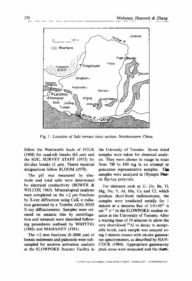
Fig. 1: Location of Sale terrace loess section, Northwestern China.
follow the Wentworth Scale of FOLK the Univesity of Toronto. Seven dried (1968) for sand-silt breaks (63 #m) and samples were taken for chemical analy- the SOIL SURVEY STAFF (1975) for sis. They were chosen to range in mass silt-clay breaks (2 #m). Parent material from 700 to 850 mg in an attempt 1;o designations follow BLOOM (1978). guarantee representative samples. T~J~
The pH was measured by elec- samples were analyzed in Olympic trode and total salts were determined tic flip-top polyvials.
by electrical conductivity (BOWER & For elements such as U, Dy, Ba, Ti, WILCOX 1965). Mineralogical analyses Mg, Na, V, A1, Mn, Ca and CI, which were completed on the <2 #m fractions produce short-lived radioisotopes, the by X-ray diffraction using CuK 0t radia- samples were irradiated serially for 1 tion generated by a Toshiba ADG-301H minute at a neutron flux of 1.0xl011 n X-ray diffractometer. Samples were ori- cm -2. s -1 in the SLOWPOKE nuclear re- ented on ceramic tiles by centrifuga- actor at the University of Toronto. After tion and minerals were identified follow- a waiting time of 19 minutes to allow the ing procedures outlined by WHITTIG very short-lived 28A1 to decay to accept- (1965) and MAHANEY (1981). able levels, each sample was assayed us-
The <2 mm fractions (0-2000 #m) of ing 5 minute counts with on-site gamma- loessic sediments and paleosols were sub- ray spectrometers, as described by HAN- sampled for neutron activation analysis COCK (1984). Appropriate gamma-ray at the SLOWPOKE Reactor Facility in peak areas were measured and the clu~-
CAI'ENA An Interdisciplinary Journal of SOIL SCIENCE HYDROLOGY GEOMORPHOLOC)~¢
Stratigraphy and Paleosols in Loess, N-W China 359
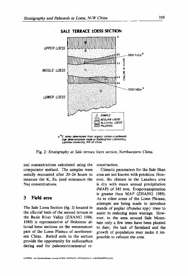
SALE TERRACE LOESS SECTION 0
5000 + llO yr a
33 ~
:':':i':.:.".:.'.'." ":.'::::..'.'.."'.." i" i;.'.?; ~" !.'):.:. M I D D L E L O E S S . : . : : . . . ; . : . . . . . . : . . . . . . . . . . . . " . " . . " "... • . . . . " . . . " , " . ' . : . • m " . . - . . . . . . . . . . : ....:.........:.......-.-.:
4.4 m~
• 4,6
ii:ii!!!ii: !F 753o+_ oyr
LOWER LOESS ~
[] SAMPLE
[]TN AEOLIAN LOESS ALLUVIAL LOESS PALEOSOL
a 14C dotes determined from organic corbon in pdleosoIs. Age tl letormir~tia~ mode at Radiocarbon Laboratory, Lonzhou University, t?1~ of Chino
Fig. 2: Stratigraphy at Sale terrace loess section, Northwestern China.
ical concentrations calculated using the construction. comparator method. The samples were Climatic parameters for the Sale Shan serially recounted after 20-24 hours to area are not known with precision. How- measure the K, Eu (and remeasure the ever, the climate in the Lanzhou area Na) concentrations, is dry with mean annual precipitation
(MAP) of 545 mm. Evapotranspiration is greater than MAP (ZHANG 1989).
3 Field area As in other areas of the Loess Plateau, attempts are being made to introduce
The Sale Loess Section (fig. 2) located in stands of poplar (Populus spp.) trees to the alluvial beds of the second terrace in assist in reducing mass wastage. How- the Baxie River Valley (ZHANG 1986, ever, in the area around Sale Moun- 1989) is representative of Holocene al- tain only a few trees have been planted luvial loess sections on the westernmost to date; the lack of farmland and the part of the Loess Plateau of northwest- growth of population may make it im- ern China. Buried soils in the section possible to reforest the area. provide the opportunity for radiocarbon dating and for paleoenvironmental re-
CATENA--An Interdisciplinary Journal of SOIL SCIENCE--HYDROLOGY--GEOMORPHOLOGY
0
N
Sale
shan
230O
lo
ess
ridge
Qz
= 220
0~4_
_,
I sl
°pew
ask°
es
I G
EO
MO
RP
HIC
LO
CA
TIO
N]
~II~
~---
__:_
--Z
~_-
~ /
of L
OE
SS
PR
OF
ILE
t
N
"1"4 ~
----
----
-~Z
-Z--
----
'--_
--~
- ~
21~)
_
I /
2 ~ I
----
----
----
---
-----;
----. -
-----_
_
• > ..
....
..
- ab
ando
ned
man
mad
e I>
..
....
...
"--
"~
T3
chan
nel
chan
nel
~, ~
" ~-~Z
-_--
_. ~
---.
~---
--~.
--
_- -"
=
---_
-Z-"
----
----
" ---
---"
a"
2000
..
....
....
1"2
flo
odpl
ain
i I
i ~
~-
-Z
--
C-
---- ..
..
• .-_
- T~
I
; T2
J
_...
,=t.
,===
==~=
~,,~
_-_-
-_--
----
----
---.
--
_ _-
__--
---~
__-
-. -
___ _
-_. ..
....
...
- _.
. ~
_'_,
~-~-
_ .
..
.
~ -~
=-_
-___
,_-_
_, _'
____
_ _
_ =
......
.....
3 -
- -
....
. -
..
..
..
..
..
--.
- ----
---
- --
(m
odiF
ied
from
Z~,
'~J,
198
3.)
CR
OS
S-V
AL
LE
Y
PR
OF
ILE
of
th
e B
AX
IE
RIV
ER
in
S
AL
ES
HA
N
LA
ND
SL
IDE
A
RE
A
~--~
= LO
EssS
LOPE
WAS
H-AL
LUVIA
LLoE
SS
(Q2)lQ3
* Q¢)
LO
ES
S J
incl
udin
g pa
leos
ols
~
loes
s i
B A
LLU
VIA
L gr
avel
N2 (R
ed b
eds;
Lin
xia
Zu F
ro)
~
S s Fi
g, 3
: C
ross
-val
ley p
rofil
e .fr
om t
he S
aie
Shah
rid
ge to
the
Bax
ie R
iver
. @
a
Stratigraphy and Paleosols in Loess, N-W China 361
4 Results and discussion younger organic carbon. Hence, the 14C dates are likely reliable giving true times
4.1 Stratigra0hy and paleosols of burial.
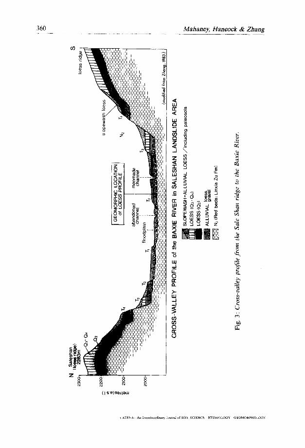
The loess stratigraphy and paleosols are 4.2 Particle size shown in figs. 2 and 3. The lower allu- vial unit appears to have a higher bulk Particle size ratios (tab. l) were analyzed density than the middle and upper units to determine if differences exist among (hence the different degrees of shading the three parent materials and the two in fig. 2), but otherwise they all have paleosols. In all, sand is low but remark- similar bulk densities (1.0-1.2 g/cm-3), ably uniform across the sequence. Silt All alluvial loess belongs to the T2 sur- distributions vary somewhat, and with face (fig. 3) of Holocene age that over- the exception of the lower unit, tend to lies Linzia Zu Formation of Pliocene age increase upwards in the sequence. How- (ZHANG 1989). Color is a nearly uni- ever, there is little overall appreciable form pale yellow (approximately 2.5Y difference in silt content between loess 6/4 to 7/4 on a dry basis) across each beds in the sequence with the exception alluvial and aeolian unit. There is lit- that the lower and upper units contain tie textural variation between the loesses 10 to 15% higher amounts than the mid- and no mottling was observed in the dle unit and the paleosols. With respect field. Radiocarbon dates in the lower to percnt clay, the lower paleosol has paleosol indicate it was buried approxi- the highest amount relative to the under- mately 7530___160 yr BE The upper pa- lying parent material, indicating that it leosol yielded a 14C date of 5000+110 yr may have formed in sito under a slightly BP. The ages of these two paleosols are wetter paleoclimate than today or over based on dates obtained from the organic a longer time interval. The upper pa- carbon fraction of the paleosols. The leosol actually contained less clay than depth relationships show that all loess that found in its parent material. While units are rather thin to the order of 1.0 it is highly possible that some clay was to 3.0 m in thickness (fig. 2). translocated into the underlying parent
The paleosols have colors that range material, it is more likely that insufficient from brownish gray (upper) (10YR 4/1) time had elapsed for its genesis. Because to black (lower) (10YR 2/1) under field the middle unit is so thin, it is likely conditions. After drying in the labora- that some of its clay content is inher- tory these colors lose only one value and ited from erosion of the lower paleosol one or two chroma becoming brownish during the alluvial event that emplaced black and grayish yellow brown. The it. In general, the particle size data tend lower paleosol has the darkest colors to support the stratigraphy observed in suggesting a higher organic carbon con- the field and the available radiocarbon tent, which was confirmed by weight loss dates. on ignition (estimated at ,,~4.0 percent). Because these paleosols are covered with 4.3 Mineralogy fresh unconsolidated alluvial and aeo- lian loess beds that lack root systems, we The mineralogy (tab. 2) of the Sale ter- believe they are not contaminated with race section was analyzed to determine if
CATENA--An Interdiseip/inary Journal of SOIL S C I E N C E ~ Y D R O L O G Y - X i E O M O R P H O L O G Y
362 Mahaney, Hancock & Zhang
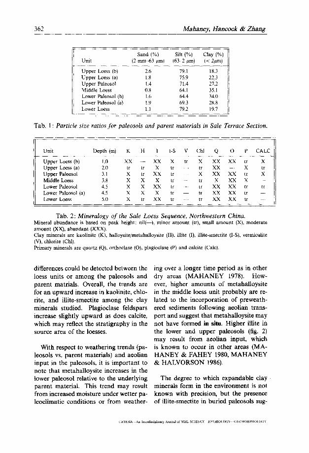
Sand (%) Silt (%) Clay (%) Uni t (2 m m - 6 3 / ~ m ) (63-2 #m) (< 2#m)
Upper Loess (b) 2.6 79.1 18.3 Upper Loess (a) 1.8 75.9 22.3 Upper Paleosol 1.4 71.4 27.2 Middle Loess 0.8 64.1 35.1 Lower Paleosol (b) 1.6 64.4 34.0 Lower Paleosol (a) t.9 69.3 28.8 Lower Loess 1.1 79.2 19.7
Tab. 1 : Particle size ratios for paleosols and parent materials in Sale Terrace Section.
Unit Depth (m) K H I I-S V Chl Q O P C A L C
Upper Loess (b) k0 XX - - XX X tr X XX XX tr X Upper Loess (a) 2.0 tr tr X tr - - tr XX - - X tr Upper Paleosol 3.1 X tr XX tr - - X XX XX tr X Middle Loess 3.8 X X X tr - - tr X XX X - - Lower Paleosol 4.5 X X XX tr -- tr XX XX tr tr Lower Paleosol (a) 4.5 X X X tr - - tr XX XX tr --- Lower Loess 5.0 X tr XX tr - - tr XX XX tr ....
Tab. 2: Mineralogy of the Sale Loess Sequence, Northwestern China. Mineral abundance is based on peak height: nil(--), minor amount (tr), small amount (X), moderate amount (XX), abundant. (XXX). Clay minerals are kaolinite (K), halloysite/metahalloysite (H), illite (I), illite-smectite (I-S), vermiculite (V), chlor i te (Chl). Primary minerals are quartz (Q), orthoclase (O), plagioclase (P) and calcite (Calc).
differences could be detected between the ing over a longer time period as in other loess units or among the paleosols and dry areas (MAHANEY 1978). How- parent matrials. Overall, the trends are ever, higher amounts of metahalloysite for an upward increase in kaolinite, chlo- in the middle loess unit probably are re- rite, and illite-smectite among the clay lated to the incorporation of preweath- minerals studied. Plagioclase feldspars ered sediments following aeolian trans- increase slightly upward as does calcite, port and suggest that metahalloysite may which may reflect the stratigraphy in the not have formed in situ. Higher illite in source area of the loesses, the lower and upper paleosols (fig. 2)
may result from aeolian input, which With respect to weathering trends (pa- is known to occur in other areas (MA-
leosols vs. parent materials) and aeolian HANEY & FAHEY 1980, MAHANEY input in the paleosols, it is important to & HALVORSON 1986). note that metahalloysite increases in the lower paleosol relative to the underlying The degree to which expandable clay parent material. This trend may result minerals form in the environment is not from increased moisture under wetter pa- known with precision, but the presence leoclimatic conditions or from weather- of illite-smectite in buried paleosols sug-
CATENA An Interdisciplinary Journal of SOIL SCIENCE HYDROLOGY GEOMORPHOLOGY
Stratigraphy and Paleosols in Loess, N-W China 363
gests it may have been an important ied. The trend shown on tab. 3 indicates weathering product in middle Holocene a depletion of salts downward in the se- paleoenvironments. The origin of ver- quence with somewhat lower values in miculites in the upper unit is obscure, the paleosols. This might suggest re- but appears to be the result of airfall moval of minor amounts of salt during influx rather than of weathering in situ. the time each paleosol was exposed to Chlorites in the sequence are diochta- subaerial weathering. hedral (Fe chlorites), as indicated by The distributions of the 13 elements the 001 peaks on X-ray diffractograms shown in tab. 4 show an overall simi- (MAHANEY 1978). Because chlorite in- larity among the three loesses and two creases upwards in the sequence, it likely paleosols. The only major break occurs reflects the source area of loess. The between the lower paleosol and underly- upper paleosol was likely exposed for ing loess where CI increases downwards too short a time, under too dry a cli- and this is probably an environmental mate, to chloritize iUite, and illite does rather than a geochemical effect. Slight not decrease with increasing chlorite. In- decreases in Ca in the two paleosols and creasing amounts of calcite upwards in middle loess may be the result of minor the younger units may signal drier pa- leaching effects. leoclimatic conditions, perhaps resulting Ratios of Na/A1, Ca/AI and Mn/A1 from the removal of forests by local in- were analyzed (tab. 5) to determine habitants (see MAHANEY & ZHANG if they provide information on relative 1990). rates of removal of mobile elements rela-
tive to immobile ones. Sodium is only 4.4 Chemistry slightly responsive showing differences
among the two paleosols relative to the The dry colors (tab. 3) of the indi- loesses. The ratio Ca/AI gives somewhat vidual units range from dull yellowish lower quotients in the paleosols, indicat- brown, grayish yellow brown to dull ing a slight tendency towards Ca deple- yellow orange. In general, the pale- tion during the time of paleosol forma- osols are slightly darker (10YR 4/3; tion. The relative movement of Mn in- 5/2) compared with the parent materi- dicates slightly enriched Mn in the lower als. Buried paleosols are actually fos- and upper paleosol as well as in the mid- sil ochric epipedons (SOIL SURVEY die loess. These data indicate also that STAFF 1975). The parent material col- the middle loess contains some preweath- ors indicate a considerable proportion ered material from the lower paleosol, of preweathered sediments were incor- and agrees with the mineralogical analy- porated in the deposits following eo- sis. lian/alluvial transport.
The pH (tab. 3) was measured to de- 4.5 Correlation termine if differences existed between the paleosols and parent materials. Even The nearest sites to the Sale terrace though the paleosols are slightly less al- section with comparable Holocene se- kaline, the differences (~0.5 pH unit) are quences are at Longxi, about 125 km to relatively minor. Total salts also show the southeast, and at Luochuan 300 km few differences among the samples stud- east (fig. 1).
CATENA--An Interdisciplinary Journal of SOIL S C 1 E N C E - - H Y D R O L O G Y ~ E O M O R P H O L O G Y

364 Mahaney, Hancock&Zhang
u nit Color (1:5) (mmhos/25°C) (1:5)
Upper Loess (b) 10YR 6/3 9.0 .54 Upper Loess (a) 10YR 6/3 9.0 .47 Upper Paleosol 10YR 5//2, 5/'3 8.6 .13 Middle Loess 10YR 4/"3 8.5 .19 Lower Paleosol (b) 10YR 4/3 8.7 .14 Lower Paleosol (a) 10YR 4/3, 5/3 8.8 .10 Lower Loess 10YR 6/4 9.0 .11
Tab. 3: Dry color, pH and electrical conductivities of parent materials and paleosols in the Sale Loess Section.
Na Mg A1 CI K Ca Ti V Mn Ba Eu Dy U Sample (%) (%] (%) (%) (%)
Upper Loess (b) 1.28 0.9 6.0 <200 1.9 5.2 3130 68 567 500 0,78 2.4 2.1 Upper Loess (a) 1.30 1.0 6.1 <230 1.9 5.9 3250 70 583 480 0,88 2.6 3.6 Upper Paleosol 1.19 0.9 6.2 _<220 2.1 4.0 3670 72 689 670 0,88 3.1 2.9 Middle Loess 1.17 1.2 6.4 _<180 2.0 4.2 3350 86 743 600 0.90 3.t 2.9 Lower Paleosol (b) 1.14 1.2 6.6 _<200 1.9 4.1 4070 75 722 490 0.86 3.3 2.9 Lower Paleosol (a) 1.22 1.0 6.5 _<190 2.1 3.5 3400 75 739 510 029 3.7 3.6 Lower Loess 1.28 1.2 6.1 600 1.8 5.4 3270 66 613 450 0.86 3.3 3.3
Tab. 4: Elemental chemistry* of the Sale Terrace Section, northwestern China. * Elemental concentrations in ppm unless otherwise indicated.
Caxl00 Naxl000 Sample Na/A1 Ca/A1 Mn/A1 Ti Ti
Upper Loess (b) 0.21 0.87 95 0.17 0.41 Upper Loess (a) 0.21 0.97 96 0.18 0.40 Upper Paleosol 0.19 0.65 111 0.11 0.32 Middle Loess 0.18 0.66 116 0.13 0.35 Lower Paleosol (b) 0.17 0.62 109 0.10 0.28 Lower Paleosol (a) 0.19 0.54 113 0.10 0.36 Lower Loess 0.21 0.89 100 0.17 0.39
Tab. 5: Elemental ratios .from the Sale Terrace Section, northwestern China.
A t L u o c h u a n , H o l o c e n e pa l eoso l s nus) env i ronmen t s . T h e fossil snai l d a t a
(fig. 4A) wi th dep ths o f 0.5 to 1.5 m p rov ide s o m e w h a t less re l iab le pa leoc l i -
in aeo l i an loess h a v e b e e n s tud ied for m a t i c i n f o r m a t i o n ( L I U et al. 1985).
po l l en a n d fossil snai l c o n t e n t ( L I U et H o w e v e r , Metodontia beresowskii indi-
al. 1985). T h e three pa l eoso l s show a ca tes a w a r m e r a n d we t t e r c l ima te t h a n
po l l en success ion d o w n w a r d tha t t r ends p re sen t a n d Cathaica pulveraticula indi-
f r o m s u b h u m i d (Gramineae) a n d semi- cates d r ie r a n d co lde r cond i t ions . Be-
ar id (Artemisia) to h u m i d (Betula, Pi- cause on ly the lower p a l e o s o l at Lu-
(A1ENA An Interdisciplinary Journal of SOIL SCIENCE- HYDROLOGY (iEOMORPHOLOGY
Stratigraphy and Paleosols in Loess, N - W China 365
A. POLLEN FOSSIL SNAILS 0-
,,:~-:,,!:.!.,"..~:.::,-:::... Grom/neoe Metodontia beresowski/ O.5- ( Moel lendorf f )
• ; : ? . . ~ . . . . . . . .
I o - ;':'~:;;~:~:'<":": Artem/s/a sp. Metodonha hausa/ensis ~, (Crosse)
:.~-,~.~-~, ~,~ Betula sp Cathoica pu/vera/?cula LS- ' P/nus sp. (Martens)
2o- ~ LOESS ! : i : i A l luv ia l loess
Aeolian loess
B. 14C P O L L E N ,..,.........-..;.......-...,:.v...., ::::::::::::::::::::::::::::::::::::::::: .:.:.:-:.:.:.:.:,:.:.:.:.:.:.:.:.:.:,:.:.:. :::::::::::::::::::::::::::::::::::::::::
t- .:.:.:.:.:.:.:.:.:.:.:.:.:.:.:.:.:.:.:.:. Befula sp Carpinu$ sp. ....,.......,.-:,.,-.v.......,.....v :':'.,:'..i:i::'!:::;':'i::?..i::.:i:i::;:,:i ~ . : . : . : , ~ 7~,o*_a~o Pinus sp. Fig. 4: Loess stratigraphy o f
z- !":??"-'..::-.~:'.?':.??i:i:"i:i:! Artemisia sp. Polygonoceae northwestern China. ~ asso*_3oo Chenopodioceoe A: Holocene sequence at Luochuan, northwestern China
3- B: Holocene sequence at Longxi, northwestern China
ochuan is dated (8100-t-220 yr BP), it terrace section, the upper paleosol at is possible to tentatively correlate it with Longxi (ZHANG & HU 1989), dated at the oldest paleosol at Longxi which dates 73604-250 yr BP appears to be equivalent from 85504-300 yr BP. If the two upper to the older paleosol in the Sale terrace paleosols at Luochuan are coeval with section. Indeed, one standard deviation the two paleosols from the Sale terrace of the upper Longxi paleosol would in- section, the paleoclimatic trends appear elude the 7530+160 yr BP date of the to be out of phase. Clearly additional lower Sale terrace paleosol. While the investigations are required to adequately mineralogy, soil chemistry and geochem- reconstruct paleoclimate in this part of istry are not available for the Longxi the Loess Plateau. paleosol sequence, the presence of Pinus
At Longxi, the Holocene sequence pollen in the upper Longxi paleosol sug- (LIU et al. 1985) of paleosols (fig. 4B) gests a somewhat wetter climate.
formed in aeolian (lower) and alluvial (upper) loesses give somewhat differ- 5 Conclusions ent ages (WEN et al. 1982). The lower paleosol, ]4C dated at 85504-300 The results of this study suggest that de- yr BP, formed in a drier climate (e.g. tailed analyses of episodic alluvial and Artemisia pollen) after the cessation of aeolian loess deposits and paleosols may aeolian loess deposition. While no cor- yield important information on age of relative paleosol is known at the Sale paleosols and paleoclimates that per-
CATENA--An Interdisciplinary Journal of SOIL S C I E N C E - - H Y D R O L O G Y ~ E O M O R P H O L O G Y
366 Mahane.y, Hancock & Zhang
sisted during the time of their develop- the assistance of David Hinbest) and the ment. At the Sale Terrace Section two Radiocarbon Laboratory of the Geog- paleosols with similar characteristics are raphy Department, Lanzhou University. shown to have slightly different miner- Additional funding from the President's alogic and chemical characteristics after NSERC fund at York Univ. is Grate- closer laboratory study. The lower pale- fully acknowledged. Janet Allin drafted osol, as indicated by stratigraphic posi- the illustrations. tion and a 14C date, is the older, Labora- tory analyses confirm it may have formed References under a wetter paleoclimate (not sup- ported by pH and total salt content) that BIRKELAND, P.W. (1984): Soils and Geomor- may have allowed the formation ofmeta- phology. Oxford, N.Y., 372 p. halloysite. Because the genesis of meta- BLOOM, A.L. (1978): Geomorphology: A Sys- halloysite is slow and requires a humid tematic Analysis of late Cenozoic Landforms.
Prentice Hall, Englewood Cliffs, N.J., 510 p. climate, the magnitude of paleoclimatic change required is likely higher than BOU¥0UCOS, G.J. (1962): Hydrometer
method improved for making particle size anal- can be substantiated from the available yses. Agron. Jour. 54, 464-465. pedological data. Therefore, the meta-
BOWER, C.A. & WILCOX, L.V. (1965): Soluble halloysite is likely preweathered. The salts. In: C.A. Black (ed.), Methods of Soil tendency for calcite to increase upward Analysis: Part 2. Amer. Soc. Agron. Madison, in the sequence suggests that climate has Wisc., 933-951. become drier over the last few millennia DAY, P. (1965): Particle fractionation and parti- or since the middle Holocene. cle size analysis. In: C.A. Black (ed.), Methods
Neutron activation data reveal overall of Soil Analysis. Amer. Soc. Agron,, Madison, Wisc., 545-567.
chemical homogeneity among the loesses and paleosols studied. The paleosols FOLK, R.L. (1968): Petrology of Sedimentary
Rocks, Hemphill Press, Austin, Texas, 170 p. reveal only slight removal of Ca and Na and minor enrichment of Mn (all HANCOCK, R.G.V. (1~4): On the source of
clay used for Cologne Roman pottery. Ar- relative to A1) during paleosol-forming chaeometry 26, 210-217. episodes. The overall conclusion that
LIU, D. et al. (1985): Loess and Environment, some preweathered sediment (formed in Science Press, p. 92.
the lower paleosol) was redistributed by MAHANEY, W.C. (1978): Late Quaternary aeolian activity into the middle loess fol- stratigraphy and soils in the Wind River Moun- lows from the elemental trends, rains, western Wyoming. In: W.C. Mahaney
(ed.), Quaternary Soils. Geoabstracts, Norwich, U.K., 223-264.
Acknowledgements MAHANEY, W.C. (1981): Paleoelimate recon- structed from paleosots: evidence from the
We thank the U.N, Development Pro- Rocky Mountains and East Africa. In: W.C. gramme in China for financial support. Mahaney (ed.), Geoabstracts. Norwich, U.K. Field work was carried out with assis- 227-248. tance from graduate students at Lanzhou MAHANEY, W.C. & HALVORSON, D,L. University, People's Rep. of China. Lab- (1986): Rates of mineral weathering in R.ocky oratory work was completed in the Ge- Mountain glacial sequences: evidence from
western Wyoming. In: S.M, Colman (ed.), Rates omorphology and Pedology Laboratory, of Chemical Weathering of Rocks and Minerals. York University, Atkinson College (with Academic Press, N.Y., 147-167.
CATENA -An Interdisciplinary J¢~utnal of SOIL SCIENCE~ HYDROLOGY GEOMORPHOLOGY
Stratigraphy and Paleosols in Loess, N-W China 367
MAHANEY, W.C. & FAHEY, B.D. (1980): Mor- phology, composition, and age of a buried pa- leosol on Niwot Ridge, Front Range, Colorado, USA. Geoderma 25, 209-218.
MAHANEY, W.C. & ZHANG, L. (1990): Re- moval of local alpine vegetation ( Hamamelis mollis) and overgrazing in the DaLiJia Shan, Northwestern China, Mountain Research and Development, in press.
OYAMA, M. & TAKEHARA, H. (1970): Stan- dard Soil Color Charts, Japan Research Council for Agriculture, Forestry and Fisheries.
SOIL SURVEY STAFF ('1951): Soil Survey Manual. Washington U.S. Gov't. Printing Office, 503 p.
SOIL SURVEY STAFF (1975): Soil Taxon- omy. Agriculture Handbook 436, Washington, U.S,D.A., 754 p.
WEN, Q., ZHENG, H., HAN, J., WANG, J., SHAOMONG, L., QIAO, Y., WEI, L. & DIAO, G. (1982): Loess of the Longxi Basin in Gansu Province. Scientia Geographica Sinica 2(3), 202-209.
WHI'I"rlG, L,D. (1965): X-ray diffraction tech- niques for mineral identification and mineralog- ical composition. In: C.A. Black (ed.), Methods of Soil Analyses. Amer. Soc. Agronomy, Madi- son, Wise., 671--696.
ZHANG, L. (1986): Paleoenvironment factors and development process of Saleshan Landslide area. Landslide Symposium No. 6, Railroad Press (In Chinese).
ZHANG, L. (1989): The landslide history and late Cenozoic environmental factors in Saleshan area, Dongxiang County, Gansu. Internat. Field Addresses of authors: Workshop on Loess geomorphological Process William C. Mahaney and Hazards, May 23-June 5, 1989. Journal of Department of Geography Lanzhou Univ. Geomorphology and Pedology Laboratory
ZHANG, L. & SHIWEI, Z. (19113): The land- Atkinson College York University
slide of Saleshan Ridge in the County of Dongx- 4700 Keele Street iang, Gansu Province, China. Nature Journal North York, Ontario 6(12), 918-923. Canada M3J 1P3
ZHANG, W. & HU, S. (1989): On the age R.G.V. Hancock and processes of formation of Heilusol (Cam- SLOWPOKE Reactor Facility and bisol) in the Loess Plateau Area in Eastern Department of Chemical Engineering and Applied Gansu Province, Kexiu Tongbao (SCIENCE Chemistry BULLETIN), No. 16, 1251-55. University of Toronto
ZHANG, L. & ZHANG, D. (1989): A compar- Toronto, Ontario ative study of paleoenviromnental factors be- Canada M5S 1A4 tween both catastrophic Saleshan and Chana Linyuan Zlmng landslides. Proc. Japan-China Symposium on Department of Geography Landslides and Debris Flows, 1989. Niigata, Lanzhou University Tokyo, Japan. Lanzhou, Peoples Republic of China
CATENA--An Interdisciplinary Journal of SOIL S C I E N C E ~ H Y D R O L O G Y ~ E O M O R P H O L O O Y