Embed Size (px)
Citation preview
Stratigraphic Framework and Correlation of the Tertiary lignite-Bearing Formations from. Southeast Missouri to the Fort Pillow Test Well of West Tennessee
U.S. GEOLOGICAL SURVEY BULLETIN 1644

,j
, I
• -=J~~~~~p . .. ., ll lj
1 F;;;~ "
.,. II ......
. ~1~ ...... ~ = ~ .. ~-~
r' • I '·-,/ ..... ... - -·· • ""i't l
~~ . I. ~
~i r r' ft ~ tij~
.I I' j llo =- !IY"~
II'~"' I.~--
l -if-·r~-Dl ···~ ·=
" -~ ... "otj
• • :II
.ori"" .. ~·~ " 0 "1 I ~ ~.- .:;~·· ., ,_ ~ .... _. .
- • ~.J· ~-.... - • n I .,. - .. ,.
:'" =-:a=-=.
• II t:r fi:. - ~- ~ "a .. \ .. '• .
I I .or.· .. I I
:ll ~, ...... : .
.. ..
Stratigraphic Framework and Correlation of the Tertiary Lignite-Bearing Formations from Southeast Missouri to the Fort Pillow Test Well of West Tennessee
By JOANNE K. OMAN
U.S. GEOLOGICAL SURVEY BULLETIN 1644
DEPARTMENT OF THE INTERIOR
DONALD PAUL HODEL, Secretary
U.S. GEOLOGICAL SURVEY
Dallas L. Peck, Director
UNITED STATES GOVERNMENT PRINTING OFFICE: 1986
For sale by the Books and Open-File Reports Section, U.S. Geological Survey, Federal Center, Box 25425, Denver, CO 80225
Library of Congress Cataloging-in-Publication Data
Oman, joanne K. Stratigraphic framework and correlation of the Tertiary lignite-bearing formations from southeast
Missouri to the Fort Pillow test well of west Tennessee.
(U.S. Geological Survey bulletin ; 1644) Bibliography: p. 7 1. Geology, Stratigraphic-Tertiary. 2. Stratigraphic correla
tion-Missouri-New Madrid Region. 3. Stratigraphic correlation-Tennessee-Fort Pillow Region. 4. BoringsMissouri-New Madrid Region. 5. Borings-TennesseeFort Pillow Region. 6. Lignite-Missouri-New Madrid Region. 7. lignite-Tennessee-Fort Pillow Region. I. Title. II. Series: Geological Survey bulletin ; 1644.
QE75.B9 no. 1644 557.3 s [551.7'8'0976816] 84-600365 IQE69ll
CONTENTS Abstract 1 Introduction 1 Stratigraphic correlation of lignite-bearing formations of southeast Missouri 1
Well A-New Madrid test well 2 Well B 3 Well C 4 Well D 4 WellE 4 Well F 4 Well G 5 Plate 1-Summary 5
Stratigraphic correlation of lignite-bearing formations from the New Madrid test well in southeast Missouri to the Fort Pillow test well in west Tennessee 6
Plate 2-Summary 7 References 7
PLATES [Plates are in pocket]
1. Stratigraphic correlation of lignite-bearing formations in southeast Missouri 2. Stratigraphic correlation of lignite-bearing formations from the New Madrid test well,
southeast Missouri, to the Fort Pillow test well, west Tennessee
TABLES
1. Nomenclature for the stratigraphic sections discussed in this report 2 2. List of wells on file with the Missouri Geological Survey and referred to in this
report 3
Contents Ill

Stratigraphic Framework and Correlation of the Tertiary Lignite-Bearing Formations from Southeast Missouri to the Fort Pillow Test Well of West Tennessee By Joanne K. Oman
Abstract
The Tertiary lignite-bearing formations of southeast Missouri are correlated to the New Madrid test well. The sediments overlay the Cretaceous Owl Creek-McNairy Formations and include the Midway, Wilcox, Claiborne and jackson Groups. The New Madrid test well is correlated to the Fort Pillow test well in west Tennessee. This correlation clearly demonstrates the similarity of the formations in the two States and allows for the continuity of stratigraphic nomenclature in the northern part of the Mississippi Embayment.
INTRODUCTION
This report describes a stratigraphic framework and shows the correlations for the lignite-bearing formations in southeast Missouri that are a part of the northern Mississippi Embayment area. It is one of several studies by the U.S. Geological Survey Branch of Coal Resources that are focused on the lignite occurrences in the Gulf Coast Coal Province. The cross sections prepared from well log data depict the distribution of lignite and associated sediments in this area. The sediments are assigned to the Midway, Wilcox, Claiborne, and Jackson Groups of early Tertiary age and were deposited in a cyclic nearshore-deltaic environment.
The nomenclature for the stratigraphic section discussed in this report is shown in table 1.
The sediments consist of unconsolidated sand, silt, clay, and lignite beds. Unlike most coal beds that can be correlated long distances, most of these lignite beds are very lenticular and have limited areal extent. Thus, the correlation of individual lignite beds is difficult.
Two cross sections prepared from data of wells drilled in southeast Missouri and west Tennessee are included in this report. Plate 1 shows the stratigraphic section of lignitebearing formations from Stoddard County southward through Dunklin County, east through Pemiscot County, and then north into New Madrid County. Table 2 lists the location of Missouri Geological Survey wells used in this report. The six wells that are described by Grohskopf ( 1955) are correlated to strata penetrated by the New Madrid test well which was described by Crone and Russ (1979), Crone (1981), the Frederiksen and others (1982). Crone (1981) described the lithology of the New Madrid well and correlated it with the Fort Pillow well and other wells in Tennes-
see. Frederiksen verified the ages of the formation by palynology and biostratigraphy. Plate 2 shows the New Madrid, Missouri, test well correlated to the Fort Pillow, Tennessee, test well that was described by Moore and Brown (1969). This correlation was done by using electric logs and well log descriptions.
Mean sea level is the datum used to plot the log data. Although the total depth of the wells is below the base of the Tertiary sediments, only the section down to the contact of the Tertiary and Cretaceous rocks was plotted.
STRATIGRAPHIC CORRELATION OF LIGNITE-BEARING FORMATIONS OF SOUTHEAST MISSOURI
The section shown on plate 1 indicates that the sediments thicken from wells G to A with wells C and B showing the thickest sequences. The description of the lignite in most wells (particularly G through B) is poor, and it could not be determined in this study whether the drilling penetrated lignite in individual coalified logs (as in Cretaceous lignite logs in Washington, D.C.; Knox, 1966) or in beds, or both.
Plate 2 shows an attempt to correlate the New Madrid test well. which was drilled in 1978, and the samples described by Crone (1981) and Frederiksen and others (1982) to the older more generalized lithologic logs of the wells drilled by the Missouri Geological Survey (MGS) and described by Grohskopf ( 1955). The sample logs of the MGS wells shown in the cross section are on file with the Missouri Division of Geological Survey and Water Resources in Rolla, Mo. The correlations, made on the basis of lithological similarities, are a more detailed subdivision of stratigraphic units that do not agree with subdivisions used by Grohskopf (1955). In his paper, Grohskopf includes all sediments from the top of the Porters Creek Formation (Paleocene) to the base of the "Lafayette" Formation (Pliocene?) in the Wilcox Group. I have used the terminology of Moore and Brown (1969) and Crone (1981) and have correlated the stratigraphic units recognized in the MGS wells to the stratigraphic units recognized in the New Madrid test well, with the exception of placing the Old Breastworks Formation in the Midway Group (Paleocene). Frederiksen and others (1982) tentatively place the Old Breastworks Formation in the Midway Group.
Introduction 1
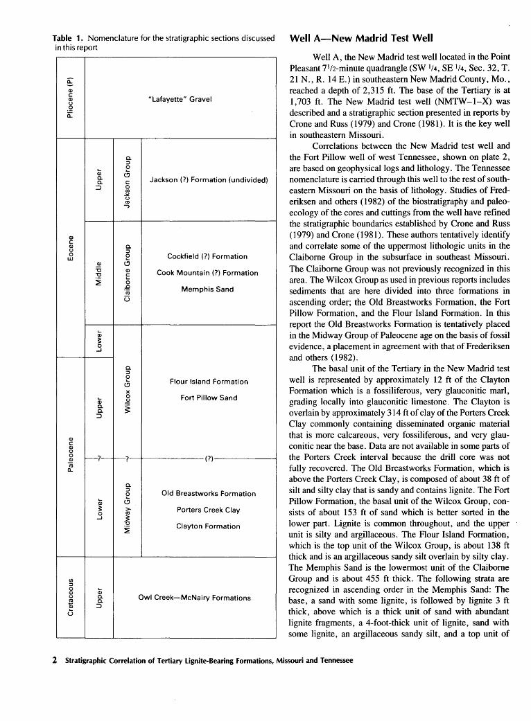
Table 1. Nomenclature for the stratigraphic sections discussed in this report
ii:" Q) c
"Lafayette" Gravel Q) (.)
.2 a:
a. ::J
Q; e a. (.!)
Jackson (?)Formation (undivided) a. c ::::> 0
CIJ ~ (.) ro -,
Q) c Q) a. (.) ::J 0 e Cockfield (?) Formation w
~ (.!)
"C Q) Cook Mountain(?) Formation "C c ~ 0 :e Memphis Sand ro
u
Q; ~ 0
....I
a. ::J e Flour Island Formation (.!)
X
Q; 0 Fort Pillow Sand ~
a. ~ a. :::::>
Q) c Q) (.)
0 -?--? (?) ~ ro a..
a. ::J
Old Breastworks Formation e Q; (.!)
~ > Porters Creek Clay 0 ro
....I ~ ~ Clayton Formation ~
CIJ ::J 0 Q; Q) (.) a. Owl Creek-McNairy Formations ~ a. Q) ::::> u
Well A-New Madrid Test Well
Well A, the New Madrid test well located in the Point Pleasant 7If2-minute quadrangle (SW If4, SE 1/4, Sec. 32, T. 21 N. , R. 14 E.) in southeastern New Madrid County, Mo. , reached a depth of 2,315 ft. The base of the Tertiary is at 1,703 ft. The New Madrid test well (NMTW-1-X) was described and a stratigraphic section presented in reports by Crone and Russ ( 1979) and Crone ( 1981). It is the key well in southeastern Missouri.
Correlations between the New Madrid test well and the Fort Pillow well of west Tennessee, shown on plate 2, are based on geophysical logs and lithology. The Tennessee nomenclature is carried through this well to the rest of southeastern Missouri on the basis of lithology. Studies of Frederiksen and others ( 1982) of the biostratigraphy and paleoecology of the cores and cuttings from the well have refined the stratigraphic boundaries established by Crone and Russ (1979) and Crone (1981). These authors tentatively identify and correlate some of the uppermost lithologic units in the Claiborne Group in the subsurface in southeast Missouri. The Claiborne Group was not previously recognized in this area. The Wilcox Group as used in previous reports includes sediments that are here divided into three formations in ascending order; the Old Breastworks Formation, the Fort Pillow Formation, and the Flour Island Formation. In this report the Old Breastworks Formation is tentatively placed in the Midway Group of Paleocene age on the basis of fossil evidence, a placement in agreement with that of Frederiksen and others (1982).
The basal unit of the Tertiary in the New Madrid test well is represented by approximately 12 ft of the Clayton Formation which is a fossiliferous, very glauconitic marl, grading locally into glauconitic limestone. The Clayton is overlain by approximately 314 ft of clay of the Porters Creek Clay commonly containing disseminated organic material that is more calcareous, very fossiliferous, and very glauconitic near the base. Data are not available in some parts of the Porters Creek interval because the drill core was not fully recovered. The Old Breastworks Formation, which is above the Porters Creek Clay, is composed of about 38 ft of silt and silty clay that is sandy and contains lignite. The Fort Pillow Formation, the basal unit of the Wilcox Group, consists of about 153 ft of sand which is better sorted in the lower part. Lignite is common throughout, and the upper unit is silty and argillaceous. The Flour Island Formation, which is the top unit of the Wilcox Group, is about 138 ft thick and is an argillaceous sandy silt overlain by silty clay. The Memphis Sand is the lowermost unit of the Claiborne Group and is about 455 ft thick. The following strata are recognized in ascending order in the Memphis Sand: The base, a sand with some lignite, is followed by lignite 3 ft thick, above which is a thick unit of sand with abundant lignite fragments, a 4-foot-thick unit of lignite, sand with some lignite, an argillaceous sandy silt, and a top unit of
2 Stratigraphic Correlation of Tertiary Lignite-Bearing Formations, Missouri and Tennessee
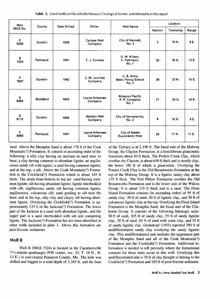
Table 2. List of wells on file with the Missouri Geological Survey and referred to in this report
Well County Date Drilled Driller MGS No.
E Dunklin 1939
Carloss Well 5293 Company
B 7324 Pemiscot 1941 T. J. Conway
F C. M. Journey 7937
Dunklin 1942 Company
G Layne-Arkansas 8363
Stoddard 1943 Company
D Dunklin 1946 Weldon Well
9110 Company
c Pemiscot 1947 Layne-Arkansas 9460 Company
sand. Above the Memphis Sand is about 178ft of the Cook Mountain(?) Formation. It consists in ascending order of the following: a silty clay having an increase in sand near its base; a clay having common to abundant lignite; an argillaceous sandy silt with lignite; a sand having common lignite; and at the top, a silt. Above the Cook Mountain(?) Formation is the Cockfield(?) Formation which is about 145 ft thick. The strata from bottom to top are sand having common lignite; silt having abundant lignite; lignite interbedded with silt; argillaceous sandy silt having common lignite; argillaceous, calcareous silt; sand grading to silt near the base; and at the top, silty clay and clayey silt having abundant lignite. Overlying the Cockfield(?) Formation is approximately 135ft of the Jackson(?) Formation. The lower part of the Jackson is a sand with abundant lignite, and the upper part is a sand interbedded with silt and containing lignite. The Jackson(?) Formation has not been identified in other wells included in plate 1. Above this formation are post-Eocene sediments.
Well B
Well B (MGS 7324) is located in the Caruthersville 71/2-minute quadrangle (NW comer, sec. 33, T. 18 N., R. 13 E.) in east-central Pemiscot County, Mo. The hole was drilled and logged to a total depth of 3,345 ft, and the base
Location Well Name
Section Township Range
City of Kennett, 2 18 N. 9 E. No.3
0. W. Killam, K. Pattinson, 33 18 N. 13 E.
No.1
U.S. Army Basic Flying School 28 23 N. 10 E.
No.2
Missouri Pacific A. A. Company 21 25 N. 10 E.
No.1
City of Hornersville, No.2 8 16 N. 9 E.
City of Steele 26 17 N. 11 E. Exploratory Hole
of the Tertiary is at 2, 190 ft. The basal unit of the Midway Group, the Clayton Formation, is a fossiliferous glauconitic limestone about 10ft thick. The Porters Creek Clay, which overlies the Clayton, is about 650 ft thick and is mostly clay, the lower 180 ft of which is glauconitic. Overlying the Porters Creek Clay is the Old Breastworks Formation at the top of the Midway Group. It is a lignitic sandy clay about 125 ft thick. The Fort Pillow Formation overlies the Old Breastworks Formation and is the lower unit of the Wilcox Group. It is about 135 ft thick and is a sand. The Flour Island Formation consists (in ascending order) of 95 ft of sandy clay, 30 ft of sand, 50 ft of lignitic clay, and 50 ft of calcareous lignitic clay at the top. Overlying the Flour Island Formation is the Memphis Sand, the basal unit of the Claiborne Group. It consists of the following lithologic units: 90ft of sand, 105 ft of sandy clay, 55 ft of sandy lignitic clay, 30 ft of sand, 65 ft of sand with some clay, and 55 ft of sandy lignitic clay. Grohskopf ( 1955) reported 390 ft of undifferentiated sandy clay overlying the sandy lignitic clay. This undifferentiated unit includes the uppermost part of the Memphis Sand and all of the Cook Mountain(?) Formation and the Cockfield(?) Formation. Additional information is needed to tell precisely where the formational contacts for these units occur in this well. Overlying this undifferentiated unit is 70 ft of clay thought to belong to the Cockfield(?) Formation and 185ft of post-Eocene sediment.
Well A-New Madrid Test Well 3
Well C
Well C (MGS 9460) is located in the Steele 7•12-minute quadrangle (SE If4, NW lf4, NE If4, sec. 26, T. I7 N., R. Il E.) in south-central Pemiscot County, Mo. The well was logged to a total depth of 2,337 ft, and the depth to the base of the Tertiary is 2, IIO ft. The basal unit of the Midway Group is the Clayton Formation which is about I4 ft thick and is a glauconitic limestone. Above the Clayton is the Porters Creek Clay, about 498 ft thick, which consists of glauconitic clay in its lower part, micaceous clay in the middle, and argillaceous micaceous silt in the top part. The top unit of the Midway Group overlying the Porters Creek Clay is the Old Breastworks Formation, which is about I43 ft thick and is mostly a sand with some silt. The Fort Pillow Formation at the base of the Wilcox Group is a coarse sand and is about 24S ft thick. The top unit of the Wilcox Group is the Flour Island Formation which consists of 9S ft of clay in the basal part, I20 ft of sand and silt in the middle part, and 3S ft of clay at the top. Overlying the Flour Island Formation is the Memphis Sand which occurs in the lower part of the Claiborne Group. It consists of 60ft of sand and clay in the basal part and 480 ft of sand with some silt in the upper part. The Cook Mountain(?) Formation above the Memphis Sand, is composed of clay in the lower 2S ft, then of 20 ft of sand in the middle part, and about 4S ft of clay in the upper part. Above the Cook Mountain(?) Formation is the Cockfield(?) Formation which was partially or incompletely sampled in this well. About 20ft of sand is reported, above which nothing is recorded. The contact between the Cockfield(?) Formation and the overlying post-Eocene sediment is arbitrarily drawn 3S ft above the top of the reported sand.
Well D
Well D (MGS 9110) is located in the Kennett ISminute quadrangle (SE If4, SW lf4, NE If4, sec. 8, T. I6 N., R. 9 E.), in southern Dunklin County, Mo. The well is logged to a depth of I ,846 ft. The base of the Tertiary (base of the Midway Group) is at a depth of I, 770 ft and is represented by the Clayton Formation, which is a glauconitic limestone IO ft thick. This formation is overlain by about 43S ft of the Porters Creek Clay, a clay unit that is glauconitic in its lower half and locally micaceous in the upper part. The overlying Old Breastworks Formation is about I 00 ft thick and consists of sand with some clay. The top of the Midway Group and base of the Wilcox Group appears to be gradational in this well and in well C. The Fort Pillow Formation is a sand unit about I 00 ft thick and is easily distinguished from the underlying Old Breastworks by the absence of clay. The Flour Island Formation is the top unit of the Wilcox Group. It is about I2S ft thick and is mostly clay with some sand interbeds. The Memphis Sand of the Claiborne Group overlies the Flour Island Formation.
It is about S40 ft thick and consists mostly of sand with occasional thin interbeds of clay, silt, and lignite. The Cook Mountain(?) Formation is about IOO ft thick and consists of silt in the upper part grading to sand at the base. It is distinguished from the underlying Memphis Sand by its higher silt content. The Cockfield(?) Formation, which overlies the Cook Mountain(?) Formation, is also silty and less sandy and is about 110 ft thick. Overlying the Cockfield(?) Formation are about 2SO ft of post-Eocene sediments.
WellE
Well E (MGS S293) is located in the Kennett ISminute quadrangle (SE 1/4, NE If4, sec. 2, T. I8 N., R. 9 E.) in central Dunklin County, Mo. The well is logged to a depth of I ,600 ft. The base of the Tertiary is at a depth of I ,463 ft. The Tertiary Clayton Formation (base of the Midway Group) is approximately I3 ft thick and is represented by a sandy glauconitic limestone. Approximately 470ft of sand grading upward into clay are assigned to the Porters Creek Clay. In places, the Porters Creek Clay is very glauconitic, and it also contains mica and some marine fossils at the base. The Old Breastworks Formation at the top of the Midway Group lies above the Porters Creek and is about 4S ft thick and consists of sand with streaks of clay. It is overlain by approximately 6S ft of sand of the Fort Pillow Formation, the basal formation of the Wilcox Group. Where present, the Fort Pillow Formation is consistent and easy to correlate throughout southeast Missouri. The top of the Wilcox Group is represented by the Flour Island Formation which is a clay interspersed with sand. The Memphis Sand, approximately 32S ft thick, is at the base of the Claiborne Group and is the principal unit of the group. It is mainly sand and in part is cherty with minor interbeds of clay. The Cook Mountain(?) Formation, which lies above the Claiborne Group, is approximately I08 ft thick. It consists of 67ft of silt and clay overlain by IS ft of sand and clay, and at the top, 26 ft of clay with a trace of lignite. The Cockfield(?) Formation, which overlies the Cook Mountain(?), is composed of 97 ft of sand in the lower section and a upper section of 97 ft of clay with some silt and sand. Approximately I7S ft of post-Eocene sediment are present above the Cockfield(?) Formation.
Well F
Well F (MGS 7937) is located in the Malden 71/2-
minute quadrangle (SW 1/4, SW If4, SE lf4, sec. 28, T. 23 N., R. IO E.) in northernmost Dunklin County, Mo. The well has been logged to a depth of 860 ft. The base of the Tertiary is at a depth of 70S ft. The base of the Midway Group (base of the Tertiary) is represented by IO ft of the Clayton Formation, which is composed of a glauconitic,
4 Stratigraphic Correlation of Tertiary Lignite-Bearing Formations, Missouri and Tennessee
fossiliferous limestone. Approximately 335 ft of clay and silt overlying the Clayton Formation are assigned to the Porters Creek Clay. The unconformity between the Midway and Claiborne Groups and the absence of the Wilcox Group reported in well G also occurs in well F. The Claiborne Group is represented by approximately 200 ft of Memphis Sand. The sediments assigned to the Cook Mountain(?) Formation and Cockfield(?) Formation are absent. The Claiborne Group is overlain by approximately 160 ft of post-Eocene sediment.
Well G
Well G (MGS 8363) is located in the Dexter 7112-minute quadrangle (SW If4, NE If4, SE If4, sec. 21, T. 25 N., R. 10 E.) in central Stoddard County, Mo. The well was originally drilled by the Missouri Geological Survey to a depth of 540 ft. The base of the Tertiary is at a depth of 225 ft. The undivided Porters Creek Clay and Clayton Formation (Midway Group), the base of the Tertiary System, is approximately 135 ft thick and is represented by a micaceous clay that is glauconitic at the base. The Midway and Claiborne Groups are separated by an unconformity. The Wilcox Group is missing due to nondeposition or erosion prior to deposition of Claiborne-age sediments. The Claiborne Group is represented by approximately 67 ft of the Memphis Sand. This sand is overlain by 20 ft of postEocene sediment. The Cook Mountain(?) Formation and Cockfield(?) Formation are absent due either to nondeposition or erosion.
Plate 1-Summary
The Clayton Formation, which is the lowest Tertiary formation and is the lowest unit of the Midway Group, is shown on the cross section (pl. 1). The Clayton ranges from 10 to 20 ft in thickness and is a glauconitic fossiliferous limestone throughout, except in well A where it is a fossiliferous, glauconitic marl and in well G where it is reported as a glauconitic clay. This glauconitic clay may be the basal part of the Porters Creek Clay, and if so, the Clayton Formation is absent in this well. The Porters Creek Clay above is generally a clay that is frequently glauconitic near the base. The formation is thinnest in wells G and F due to an unconformity at the top, and it is thickest in wells C and B where the section is complete. The Old Breastworks Formation is generally a sandy and commonly silty clay with lignite, as reported in wells Band A. In wells E, D, and Cit apparently intergrades with the overlying Fort Pillow Formation. The Fort Pillow Formation, which is the basal unit of the Wilcox
Group, is a sand that is lithologically consistent throughout wells E, D, C, B, and A and is thickest in well C. The Flour Island Formation is mostly clay, locally is sandy or silty, and is thicker in wells C, B, and A. Above the Flour Island Formation is the Memphis Sand, which is the basal unit of the Claiborne Group and is present in all the drill holes of the cross section. The Old Breastworks, Fort Pillow, and Flour Island Formations are absent in wells G and F due to nondeposition or erosion, and the Memphis Sand rests unconformably on the Porters Creek Clay. It occasionally contains interbeds of clay and silt and frequently is lignitic. The overlying Cook Mountain(?) Formation consists of interbedded silty clays and silty sandy clay with some lignite. Its upper and lower formational contacts cannot be determined in well B due to the generalized lithologic description of the well. The Cook Mountain(?) Formation is absent in wells G and F where post-Eocene sediments overlie the Memphis Sand. The Cockfield(?) Formation is composed of, in order of abundance, clay, sand, silt, sandy silt, and some lignite. Like the Cook Mountain(?) Formation the Cockfield(?) Formation is undifferentiated in well B and absent in wells G and F. The Cook Mountain(?) Formation and Cockfield(?) Formation are lithologically similar. The contact between these formations, as established in the New Madrid well, was correlated to the other MGS wells on the basis of lithologic changes that in some wells can only be arbitrarily determined from the information available. The Jackson(?) Formation, which overlies the Cockfield(?) Formation, was recognized only in well A. The contact between the formations cannot be precisely defined due to incomplete sampling. The Jackson(?) Formation is mostly sand with some interbedded silt and clay. Lignite occurrences are not reported in the Clayton Formation or Porters Creek Clay (lower-middle Midway). Lignite is reported in the Old Breastworks Formation in the easternmost wells B and A. Lignite was found in the Fort Pillow Formation in well A, but it was not reported in any of the other wells. The Flour Island Formation contains some lignite occurrences which were reported in wells B and A. The Memphis Sand contains lignite occurrences recorded in wells D, B, and A. The Cook Mountain(?) Formation has lignite in wells E and A. The Cockfield(?) Formation has lignite recorded in well A. The Tertiary stratigraphy in southeast Missouri is tentative and is based on the limited data available for this study. Until more wells are drilled and data recorded to provide the necessary information, it will be impossible to correlate specific beds and to determine the lignite resources of the area.
It appears from a study of the cross section in plate 1 that the areas of wells D, B, and A, where the formations are the thickest (perhaps because they are further into the Embayment), are the most likely target areas for lignite exploration. The Memphis Sand contains more lignite occurrences than any of the other formations and is probably the most favorable target for exploration.
Plate 1-Summary 5
STRATIGRAPHIC CORRELATION OF LIGNITE-BEARING FORMATIONS FROM THE NEW MADRID TEST WELL IN SOUTHEAST MISSOURI TO THE FORT PILLOW TEST WELL IN WEST TENNESSEE
The cross section in plate 2 starts in southeast Missouri and extends south-southwest for approximately 55 mi to west Tennessee.
Mean sea level is the datum used to plot the logs. Accompanying each stratigraphic column are a spontaneous potential curve and a resistivity curve which aid in the correlation of the two test wells. Previous work by Moore and Brown (1969), Crone and Russ (1979), Crone (1981), and Frederiksen and others (1982) established the stratigraphic ages in the wells using paleontology and palynology. The lithologic description for the New Madrid test well has been given in the discussion of plate 1 (well A). The following is the lithologic description of the Fort Pillow test well in Tennessee and its correlation with the New Madrid test well.
The Fort Pillow test well, drilled in 1965, is located in the Goldust 7112-minute quadrangle in Lauderdale County, Tenn. The well reached a depth of 3,158 ft; the base of the Tertiary is at 2,352 ft. Data from this well allowed Moore and Brown ( 1969) to redefine the subsurface Eocene stratigraphy of western Tennessee. The previously undivided Wilcox Group was divided into three new formations. They are, in ascending order, the Old Breastworks Formation, the Fort Pillow Sand, and the Flour Island Formation. Moore and Brown (1969) note that there is palynological evidence for a possible Paleocene age for the Old Breastworks Formation, but because of lithologic similarities to the two overlying formations, they prefer to retain it in the Wilcox Group (subsequently changed to upper Midway as noted later). In addition, Moore and Brown (1969) name the Memphis Sand as the basal formation of the Claiborne Group in Tennessee. The Cook Mountain(?) Formation and Cockfield(?) Formation in the upper part of the Claiborne are identified for the first time in Tennessee, but their boundaries are not established. The uppermost Eocene sediments are identified as the Jackson(?) Formation.
The Midway Group of Paleocene age is comprised of the Clayton Formation, Porters Creek Clay, and Old Breastworks Formation (changed from basal Wilcox). As noted earlier in this paper, the Old Breastworks Formation is assigned to the Midway on the basis of palynologic work by Frederiksen and others (1982). The Clayton Formation (17 ft thick) is represented by a calcareous, fossiliferous, and glauconitic clay. It grades upward into the Porters Creek Clay which, in its lower part, is a glauconitic, fossiliferous clay about 230 ft thick and overlain by 52 ft of a silty, shaley, calcareous clay. The upper part of the Porters Creek
Clay, approximately 100 ft thick, consists of a slightly sandy and calcareous clay. The Old Breastworks Formation is approximately 280 ft thick. The lowermost unit of this formation is a calcareous, glauconitic silt approximately 80 ft thick. The overlying unit is a noncalcareous silt that is slightly lignitic and is approximately 40 ft thick. A slightly lignitic sand unit, approximately 20 ft thick and having silt interbeds, occurs near the middle of the Old Breastworks Formation. Overlying this middle unit is 90ft of sandy silt containing minor amounts of glauconite and lignite. The top of the formation is an argillaceous, glauconitic, slightly calcareous, and lignitic silt.
The Fort Pillow Sand, which overlies the Old Breastworks Formation, is the basal unit of the Wilcox Group. It is 160 ft thick. At the base of the formation, 98 ft of pyritic sand containing some chert occurs. Above this base is a 5-foot-thick unit of clay. Overlying this clay is 60 ft of glauconitic sand. The Four Island Formation, the uppermost unit of the Wilcox, consists of 200 ft of silt and clay interbedded with sand and lignite.
The overlying Memphis Sand is the basal unit of the Claiborne Group and is 730 ft thick. The basal 320 ft is a sand with some chert and clear quartz, and it becomes glauconitic near the top. Above this unit is 36 ft of slightly glauconitic and pyritic sand that contains lignite. Next is 184ft of sand, pyritic in part, that has a salt and pepper appearance in the top half. Above this sand is 35 ft of sandy silt that is lignitic and slightly glauconitic. Next is a sand, 70 ft thick, that has a salt and pepper appearance. The top unit of the Memphis Sand is a salt and pepper sand that is lignitic and slightly glauconitic.
The overlying Cook Mountain(?) Formation is approximately 198 ft thick. The basal 56 ft is a silt that is argillaceous and glauconitic. There is no lithic record of the next 31 ft. Next is 23 ft of clay overlain by 36 ft of silt interbedded with clay. Overlying this unit is 34 ft of calcareous, lignitic silt interbedded with clay. The uppermost unit of the Cook Mountain(?) Formation is 18 ft of clay having a bed of pure vitreous lignite at the base.
The Cockfield(?) Formation overlies the Cook Mountain(?) Formation and is 210ft thick. The basal unit is a sand that is 16 ft thick. Overlying that unit is a 30-foot bed of argillaceous silt containing organic and lignitic particles. Next is 46 ft of sand having lignite in the lower one-half. Next again is 12 ft of argillaceous sandy silt followed by 70 ft of sand. The uppermost unit of the Cockfield(?) Formation is a 28-foot-thick clay interbedded with sand and lignite. The contact with the overlying Jackson(?) Formation is thought to be at the top of this unit and at the base of the overlying bed, which is a glauconitic sand 68 ft thick having lignite at its base. The top of the Jackson(?) Formation is a calcareous clay that grades downward to a silty sand; the unit is 30 ft thick. The Jackson(?) Formation is approximately 100ft thick. Overlying the Jackson are postEocene sediments.
6 Stratigraphic Correlation of Tertiary Lignite-Bearing Formations, Missouri and Tennessee
Plate 2-Summary
The lowermost Tertiary formation in the cross section is the Clayton Formation, the basal unit of the Midway Group. In the New Madrid test well it is a glauconitic, fossiliferous marl and is 8 ft thick. In the Fort Pillow test well it is a limy, fossiliferous clay that grades into the Porters Creek Clay and is approximately 17 ft thick. The Porters Creek Clay is calcareous, fossiliferous, and silty in places and is glauconitic near its base. The Old Breastworks Formation consists of a sandy and silty clay and shows lignite occurrences in both wells. In the New Madrid test well the Old Breastworks is 42ft thick. It thickens to 280ft in the Fort Pillow test well and is the uppermost unit in the Midway Group.
The Wilcox Group contains the Fort Pillow and Flour Island Formations. The Fort Pillow Formation is a 153-footthick sand in the New Madrid test well that thickens to 160 ft in the Fort Pillow test well where the sand contains glauconite and chert. In both wells, the Fort Pillow Sand is medium to coarse grained, but only the New Madrid well contains lignite. The Flour Island Formation is a silt (or clayey silt) having thin interbeds of clay and fine sand. It is lignitic in the Fort Pillow well but not in the New Madrid well.
Overlying the Flour Island Formation is the Memphis Sand, the basal unit of the Claiborne Group. The Memphis Sand is generally a fine to coarse-grained lignitic sand. It thickens from 455 ft in the New Madrid test well to 630 ft in the Fort Pillow test well where it contains more chert, silt, and clay. The Cook Mountain(?) Formation consists mainly of interbedded lignitic clays and silts. There is also some sand. The Cockfield(?) Formation, the uppermost unit of the Claiborne Group, is more silty in the New Madrid test well where it consists of silt and sandy silt interbedded with some sand and lignite. In the Fort Pillow test well the Cockfield(?) Formation is composed of interbeds of clays, silts, lignites, and some sand. The upper boundary is tentatively placed at 210ft in this well by Moore and Brown (1969). Overlying the Cockfield(?) Formation is the Jackson(?) Formation, which consists of interbeds of sands, silts, and clays in both wells. The Fort Pillow test well has lignite at the base of the Jackson(?) Formation.
The lithology of the two test wells is very similar. In addition, there is good correlation between the electric logs for both wells. The occurrence of lignite shown in plate 2 is similar to that found in wells A, B, and D shown in plate 1. In both wells shown in plate 2, lignite was found in the Old Breastworks Formation, Memphis Sand, Cook Mountain(?) Formation, Cockfield(?) Formation, and Jackson(?) Formation. These formations are the most favorable for further lignite exploration. The occurrences of lignite in the two wells have been described only in general terms. From the available data it is impossible to tell exactly how far these lignite occurrences extend.
REFERENCES
Crone, A. J., 1981, Sample description and stratigraphic correlation of the New Madrid test well-1-X, New Madrid County, Missouri: U.S. Geological Survey Open-File Report 81-426, 26 p.
Crone, A. J., and Russ, D. P., 1979, Preliminary report on an exploratory drill hole-New Madrid test well-1-X in southeast Missouri: U.S. Geological Survey Open-File Report 79-1216, 11 p.
Grohskopf, J. G., 1955, Subsurface geology of the Mississippi Embayment of southeast Missouri: Missouri Geological Survey and Water Resources, [Report], v. 37, 2d series, 133 p.
Frederiksen, N. 0., Bybell, L. J., Christopher, R. A., Crone, A. 1., Edwards, L. E., Gibson, T. G., Hazel, J. E., Repetski, J. E., Russ, D. P., Smith, C. C., and Ward, L. W., 1982, Biostratigraphy and paleoecology of lower Paleozoic, Upper Cretaceous, and lower Tertiary rocks in U. S. Geological Survey New Madrid test wells, southeastern Missouri: Tulane Studies in Geology and Paleontology, v. 17, no. 2, p. 23-45.
Knox, A. S. 1966, The Walker Interglacial Swamp, Washington, D. C.: Journal of the Washington Academy of Sciences, v. 56, no. 1, p. 1-8.
Moore, G. K., and Brown, D. L., 1969, Stratigraphy of the Fort Pillow test well, Lauderdale County, Tennessee: Tennessee Division of Geology Report of Investigations, 26 p.
References 7