Embed Size (px)
DESCRIPTION
The publication stresses the underlying legal, administrative and financial aspects of monitoring and assessment and discusses the constraints on and opportunities for cooperation. It draws on the experience gained with the implementation of pilot projects for transboundary rivers under the 1992 UNECE Convention on the Protection and Use of Transboundary Watercourses and International Lakes (Water Convention) and proposes step-by-step approaches that take into account the available human and financial resources, particularly in countries with economies in transition.
Citation preview
UNITED NATIONSUNITED NATIONS
STRATEGIES FOR MONITORING
AND ASSESSMENT
OF TRANSBOUNDARY RIVERS,
LAKES AND
GROUNDWATERS
E C O N O M I C C O M M I S S I O N F O R E U R O P E
Convention on the Protection and Use of Transboundary Watercourses and International Lakes
Water Convention secretariatUnited Nations Economic Commission for Europe
Palais des Nations
CH-1211 Geneva 10, Switzerland
Tel.: +41 (0)22 917 2463
Fax: +41 (0)22 917 0107
E-mail: [email protected]
Web site:http://www.unece.org/env/water/
UNECE Environment, Housing and Land Management DivisionFax: +41 (0)22 917 01 07
E-mail: [email protected]
Web site: http://www.unece.org/env/
UNECE Information UnitTel.: +41 (0)22 917 4444
Fax: +41 (0)22 917 0505
E-mail: [email protected]
Web site: http://www.unece.org
Printed at United Nations GE.06-25752–October 2006–2,215
ECE/MP.WAT/20
Unites Nations Publication Sales No. E.06.II.E.15 ISBN 92-1-116951-8

E C O N O M I C C O M M I S S I O N F O R E U R O P E
Convention on the Protection and Use of Transboundary Watercourses
and International Lakes
STRATEGIES FOR MONITORING AND ASSESSMENT
OF TRANSBOUNDARY RIVERS, LAKES AND GROUNDWATERS
UNITED NATIONSNew York and Geneva, 2006
E C O N O M I C C O M M I S S I O N F O R E U R O P E
Convention on the Protection and Use of Transboundary Watercourses and International Lakes
AcKNOWLEDGEMENTS
The UNECE secretariat gratefully acknowledges the funding by the Government of Finland. It also acknowledges the advice provided by the members of the Water Convention’s Working Group on Monitoring and Assessment and the work of the drafting group which finalized the strategies. The drafting group was composed of Ms. Sirkka Haunia and Mr. Pertti Heinonen from the Finnish Environment Institute; Mr. John Chilton from the British Geological Survey; Mr. Jos Timmerman from the Dutch Institute for Inland Water Management and Waste Water Treatment; Mr. Rafig Verdyev from the non-governmental organization ECORES (Azerbaijan); and Ms. Francesca Bernardini and Mr. Rainer Enderlein from the UNECE secretariat. Mr. Rainer Enderlein also chaired the drafting group.
NOTE
The designations employed and the presentation of the material in this publication do not imply the expression of any opinion whatsoever on the part of the Secretariat of the United Nations concerning the legal status of any country, territory, city or area, or of its authorities, or concerning the delimitation of its frontiers or boundaries.
PREFAcE
A core requirement under the 1992 UNECE Convention on the Protection and Use of Transboundary Watercourses and International Lakes (Water Convention) is the establishment of joint monitoring and assessment programmes on transboundary waters. Information based on well-organized monitoring programmes is the key prerequisite for accurate assessments of the status of water resources and the magnitude of water problems. These assessments are essential for preparing proper policy actions at the local, national and transboundary levels. Moreover, integrated water resources management in transboundary basins shared by two or more countries calls for comparable information. There is a need for a common basis for decision-making, which requires harmonized and comparable assessment methods and data management systems as well as uniform reporting procedures.
Since the adoption of the Water Convention, UNECE member States have made particular efforts to strengthen their capacity to monitor and assess transboundary waters. These activities have culminated in a number of guidelines and policy documents to show how monitoring and assessment systems can be set up under the Convention, respecting the limited availability of human and financial resources in some countries. Two important concepts have been identified: monitoring and assessment should be tailored to the specificities of the river basin, and a phased approach should be used when setting up these systems.
The Strategies for Monitoring and Assessment of Transboundary Rivers, Lakes and Groundwaters are based on the experience gained with the implementation of earlier guidelines on monitoring and assessment of transboundary rivers, lakes and groundwaters by the Parties to the Water Convention, and in particular the experience from the implementation of these guidelines in pilot projects, most noticeably in countries in Eastern Europe, Caucasus and Central Asia (EECCA). The Strategies also build on the results of workshops, training courses and other capacity-building activities conducted under the Water Convention.
The Strategies are intended to assist policy and decision makers, representatives of joint bodies, and water managers responsible for establishing and carrying out cooperation between riparian countries. They highlight the underlying legal, administrative and financial aspects of monitoring and assessment, examine the constraints on and opportunities for cooperation, and propose step-by-step approaches that take into account the available human and financial resources, particularly in countries with economies in transition.
I trust that the Strategies will provide valuable guidance to all actors involved in the implementation of the UNECE Water Convention and thereby contribute to sustainable management of transboundary waters in the UNECE region.
Marek BelkaExecutive Secretary
United Nations Economic Commission for Europe
cONTENTS
IntroductIon 1
I. BasIcprIncIplesandapproacHes 2 A. Monitoring and assessment 2 B. River basin approach 3
II. legIslatIonandcommItments 4 A. Relevant UNECE Conventions and Protocols 5 B. EU legislation 6 C. Other international commitments 8
III. estaBlIsHIngtHeInstItutIonalFrameWorK 9 A. Institutional arrangements at the national level 9 B. Institutional arrangements at the transboundary level 10 C. Institutional arrangements related to quality systems 11 D. Frameworks for exchanging and accessing information 11
IV. securIngFundIngFormonItorIngandassessment 12
V. deVelopIngstep-By-stepapproacHes 13 A. Character of step-by-step approaches 13 B. Prioritizing monitoring efforts 14 C. Use of models in monitoring and assessment 15 D. Using pilot projects 15
VI. ImplementIngmonItorIngprogrammes 16 A. Monitoring and assessment cycle 16 B. Information needs 17 C. Information strategy 19 D. Monitoring/data collection 19
VII.managIngdataandmaKIngassessments 20 A. Data management 20 B. Assessment methodology 22
VIII. reportIngandusIngInFormatIon 22 A. Reporting 22 B. Information use 24
INTRODUcTION
Information based on well-organized monitoring programmes is the key prerequisite for accurate assessments of the status of water resources and the magnitude of water problems. These assessments are essential for preparing proper policy actions at the local, national and transboundary levels. Moreover, integrated water resources management in transboundary basins shared by two or more countries calls for comparable information. There is a need for a common basis for decision-making, which requires harmonized and comparable assessment methods and data management systems as well as uniform reporting procedures.
This publication explains the key principles of and approaches to monitoring and assessment of transboundary watercourses and describes strategies for monitoring and assessing these watercourses. It highlights areas of interest to policy and decision makers and provides ground rules for water managers involved in or responsible for establishing and carrying out cooperation between riparian countries, as well as for representatives of joint bodies.
The publication stresses the underlying legal, administrative and financial aspects of monitoring and assessment and discusses the constraints on and opportunities for cooperation. It draws on the experience gained with the implementation of pilot projects for transboundary rivers under the 1992 UNECE Convention on the Protection and Use of Transboundary Watercourses and International Lakes1 (Water Convention) and proposes step-by-step approaches that take into account the available human and financial resources, particularly in countries with economies in transition.
The publication refers extensively to the UNECE Guidelines on monitoring and assessment of transboundary rivers,2 groundwaters3 and lakes4 and other guidance documents developed under the Water Convention. It also draws on the findings of workshops organized under the Water Convention’s “Capacity for Water Cooperation” project.5
1 http://www.unece.org/env/water/2 http://www.unece.org/env/water/publications/documents/guidelinestransrivers2000.pdf3 http://www.unece.org/env/water/publications/documents/guidelinesgroundwater.pdf4 http://www.unece.org/env/water/publications/documents/lakesstrategydoc.pdf and at http://www.unece.org/env/water/publications/documents/lakestechnicaldoc.pdf
5 http://www.unece.org/env/water/cwc.htm
�
�
Driving forces
Pressures
State
Impact
Responses
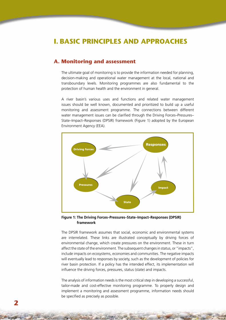
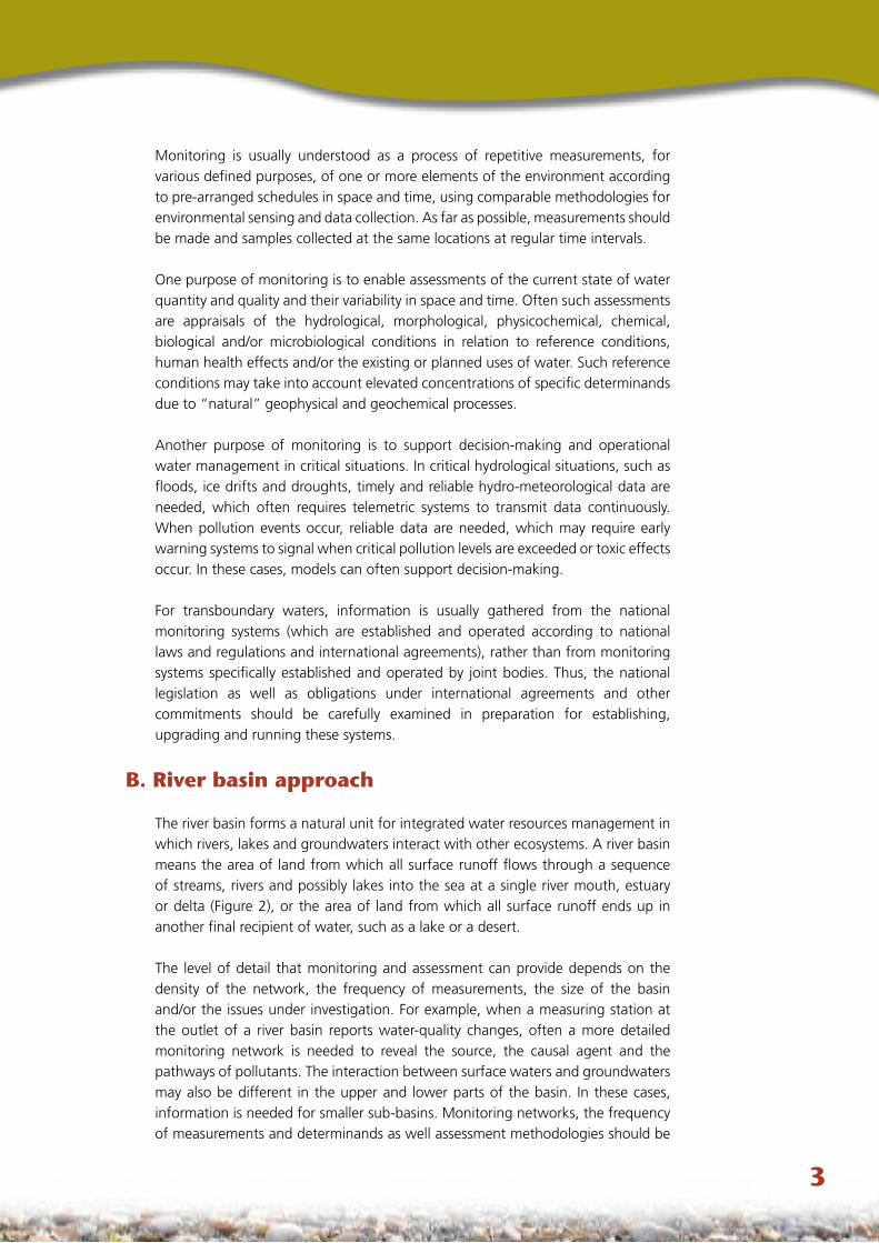
Figure 1: The Driving Forces–Pressures–State–Impact–Responses (DPSIR) framework
I. BASIc PRINcIPLES AND APPROAcHES
A. Monitoring and assessment
The ultimate goal of monitoring is to provide the information needed for planning, decision-making and operational water management at the local, national and transboundary levels. Monitoring programmes are also fundamental to the protection of human health and the environment in general.
A river basin’s various uses and functions and related water management issues should be well known, documented and prioritized to build up a useful monitoring and assessment programme. The connections between different water management issues can be clarified through the Driving Forces–Pressures–State–Impact–Responses (DPSIR) framework (Figure 1) adopted by the European Environment Agency (EEA).
The DPSIR framework assumes that social, economic and environmental systems are interrelated. These links are illustrated conceptually by driving forces of environmental change, which create pressures on the environment. These in turn affect the state of the environment. The subsequent changes in status, or “impacts”, include impacts on ecosystems, economies and communities. The negative impacts will eventually lead to responses by society, such as the development of policies for river basin protection. If a policy has the intended effect, its implementation will influence the driving forces, pressures, status (state) and impacts.
The analysis of information needs is the most critical step in developing a successful, tailor-made and cost-effective monitoring programme. To properly design and implement a monitoring and assessment programme, information needs should be specified as precisely as possible.
�
Monitoring is usually understood as a process of repetitive measurements, for various defined purposes, of one or more elements of the environment according to pre-arranged schedules in space and time, using comparable methodologies for environmental sensing and data collection. As far as possible, measurements should be made and samples collected at the same locations at regular time intervals.
One purpose of monitoring is to enable assessments of the current state of water quantity and quality and their variability in space and time. Often such assessments are appraisals of the hydrological, morphological, physicochemical, chemical, biological and/or microbiological conditions in relation to reference conditions, human health effects and/or the existing or planned uses of water. Such reference conditions may take into account elevated concentrations of specific determinands due to “natural” geophysical and geochemical processes.
Another purpose of monitoring is to support decision-making and operational water management in critical situations. In critical hydrological situations, such as floods, ice drifts and droughts, timely and reliable hydro-meteorological data are needed, which often requires telemetric systems to transmit data continuously. When pollution events occur, reliable data are needed, which may require early warning systems to signal when critical pollution levels are exceeded or toxic effects occur. In these cases, models can often support decision-making.
For transboundary waters, information is usually gathered from the national monitoring systems (which are established and operated according to national laws and regulations and international agreements), rather than from monitoring systems specifically established and operated by joint bodies. Thus, the national legislation as well as obligations under international agreements and other commitments should be carefully examined in preparation for establishing, upgrading and running these systems.
B. River basin approach
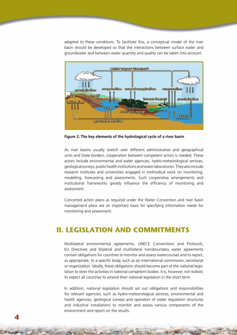
The river basin forms a natural unit for integrated water resources management in which rivers, lakes and groundwaters interact with other ecosystems. A river basin means the area of land from which all surface runoff flows through a sequence of streams, rivers and possibly lakes into the sea at a single river mouth, estuary or delta (Figure 2), or the area of land from which all surface runoff ends up in another final recipient of water, such as a lake or a desert.
The level of detail that monitoring and assessment can provide depends on the density of the network, the frequency of measurements, the size of the basin and/or the issues under investigation. For example, when a measuring station at the outlet of a river basin reports water-quality changes, often a more detailed monitoring network is needed to reveal the source, the causal agent and the pathways of pollutants. The interaction between surface waters and groundwaters may also be different in the upper and lower parts of the basin. In these cases, information is needed for smaller sub-basins. Monitoring networks, the frequency of measurements and determinands as well assessment methodologies should be
�
adapted to these conditions. To facilitate this, a conceptual model of the river basin should be developed so that the interactions between surface water and groundwater and between water quantity and quality can be taken into account.
Figure 2: The key elements of the hydrological cycle of a river basin
As river basins usually stretch over different administrative and geographical units and State borders, cooperation between competent actors is needed. These actors include environmental and water agencies, hydro-meteorological services, geological surveys, public health institutions and water laboratories. They also include research institutes and universities engaged in methodical work on monitoring, modelling, forecasting and assessments. Such cooperative arrangements and institutional frameworks greatly influence the efficiency of monitoring and assessment.
Concerted action plans as required under the Water Convention and river basin management plans are an important basis for specifying information needs for monitoring and assessment.
II. LEGISLATION AND cOMMITMENTS
Multilateral environmental agreements, UNECE Conventions and Protocols, EU Directives and bilateral and multilateral transboundary water agreements contain obligations for countries to monitor and assess watercourses and to report, as appropriate, to a specific body, such as an international commission, secretariat or organization. Ideally, these obligations should become part of the national legis-lation to steer the activities in national competent bodies. It is, however, not realistic to expect all countries to amend their national legislation in the short term.
In addition, national legislation should set out obligations and responsibilities for relevant agencies, such as hydro-meteorological services, environmental and health agencies, geological surveys and operators of water regulation structures and industrial installations to monitor and assess various components of the environment and report on the results.
�
A. Relevant UNEcE conventions and Protocols
UNECE Convention on the Protection and Use of Transboundary Watercourses and International Lakes (Water Convention)
The 1992 Water Convention’s main goal is to prevent, control and reduce any transboundary impacts, which include significant adverse impacts on human health and safety, flora, fauna, soil, air, water, climate, landscape and historical monuments or other physical structures. The Convention is one of the most essential legal instruments for the monitoring and assessment of transboundary waters in the UNECE region. Several bilateral and multilateral agreements on transboundary waters6 among UNECE countries support action required by the Water Convention.
In defining and specifying information needs, establishing monitoring systems and assessing the status of waters, it should be noted that the Convention requires the setting of emission limits for discharges from point sources on the basis of the best available technology (BAT). It also requires authorizations for wastewater discharges and the application of at least biological or equivalent processes to treat municipal wastewater.
The Convention calls for best environmental practices (BEP) to reduce the input of nutrients and hazardous substances from agriculture and other diffuse sources. In addition, Parties must define water-quality objectives for the purpose of preventing, controlling and reducing transboundary impacts.
Obligations relating to the monitoring and assessment of specific river basins that stem from bilateral or multilateral agreements should be in line with the requirements of the Water Convention. In particular, joint bodies – any bilateral or multilateral commission or other appropriate institutional arrangements for cooperation between Riparian Parties – have a specific role in monitoring and assessment.
Protocol on Water and Health to the 1992 Water Convention�
Under the Protocol on Water and Health, effective systems for monitoring and assessing situations likely to result in outbreaks or incidents of water-related disease and for responding to them or preventing them should be established. This will include inventories of pollution sources, surveys on high-risk areas for microbiological contamination and toxic substances, and reporting on infectious and other water-related diseases. The Parties must also develop integrated information systems to handle information about long-term trends in water and health; current concerns, past problems and successful solutions; and the provision of such information to the authorities. Moreover, comprehensive national and/or local early warning systems are to be established, improved or maintained.
6 http://www.unece.org/env/water/partnership/part.htm7 http://www.unece.org/env/water/text/text_protocol.htm
�
Protocol on Civil Liability and Compensation for Damage Caused by the Transboundary Effects of Industrial Accidents on Transboundary Waters (Civil Liability Protocol) �
The Civil Liability Protocol is a joint Protocol to the Water Convention and the Convention on the Transboundary Effects of Industrial Accidents (see below). It contains provisions on measures to reinstate or restore damaged or destroyed components of transboundary waters. For this purpose, it is important to know the conditions of the transboundary waters that would have existed had the industrial accident not occurred. This requires appropriate data and information on the status of transboundary waters and their components.
Convention on the Transboundary Effects of Industrial Accidents (Industrial Accidents Convention) �
The 1992 Industrial Accidents Convention is designed to protect human beings and the environment against industrial accidents by preventing them as far as possible, by reducing their frequency and severity and by mitigating their effects. The UNECE Industrial Accidents Notification System comprises a network of points of contact, which should be consulted if information on the occurrence and impact of accidental pollution on water bodies is required.
Convention on Access to Information, Public Participation in Decision-making and Access to Justice in Environmental Matters (Aarhus Convention) 10
The Aarhus Convention stipulates, inter alia, that any environmental information held by a public authority must usually be provided when requested by a member of the public. The scope of information is quite broad, including information on water and human health and safety. Public authorities may impose a charge for supplying information provided the charge does not exceed a “reasonable” amount. There is an obligation to progressively make environmental information publicly available via electronic databases. The Convention specifies certain categories of information (e.g. state of the environment reports) that should be made available in this form.
B. EU legislation
The legislation of the European Union is a major tool for defining how surface waters and groundwaters should be used, protected and restored. The two main approaches to preventing, controlling and reducing water pollution – the “water quality objective approach” and the “emission limits value approach” – play a decisive role in monitoring and assessing watercourses. The first approach sets minimum quality requirements for waters and the second one establishes maximum allowed quantities for pollutants discharged to watercourses.
8 http://www.unece.org/env/civil-liability/welcome.html9 http://www.unece.org/env/teia/welcome.htm10 http://www.unece.org/env/pp/welcome.html
�
The key directive concerning monitoring is Directive 2000/60/EC of the European Parliament and of the Council of 23 October 2000 establishing a framework for European Community action in the field of water policy (200011, 200112), hereinafter referred to as the Water Framework Directive (WFD). Specific monitoring obligations also result from other Directives applicable to EU member States, commonly referred to respectively as the 1991 Urban Waste Water Treatment Directive,13 the 1996 Integrated Pollution Prevention and Control Directive,14 the 1991 Nitrates (from Agricultural Sources) Directive,15 the 1998 Drinking Water Directive,16 the 2006 Bathing Water Quality Directive17 and the 1976 Directive on pollution caused by certain dangerous substances discharged into the aquatic environment of the European Community.18
The WFD provides the framework for the protection of surface waters, transitional waters, coastal waters and groundwaters in the EU area. The main aims of the WFD are to prevent further deterioration of and protect and enhance the status of aquatic ecosystems, to promote sustainable water use, and to mitigate the effects of floods and droughts. The environmental objective is to achieve good ecological and chemical status for waters by 2015 at the latest.
Within a river basin where use of water may have transboundary effects, the requirements for the achievement of the environmental objectives established under the WFD, and in particular all programmes of measures, should be coordinated for the whole river basin. For river basins extending beyond the boundaries of the Community, member States should endeavour to ensure appropriate coordination with the relevant non-member States. The WFD is meant to contribute to the implementation of Community obligations under international conventions on water protection and management, notably the UNECE Water Convention. The water monitoring network shall be established to provide a coherent and comprehensive overview of the ecological and chemical status of each river basin. In order to address the challenges in a cooperative and coordinated way, member States, Norway and the European Commission agreed on a Common Implementation Strategy. In the first phase of the joint process, a number of guidance documents19 covering, among other issues, monitoring and public participation were prepared.
11 http://europa.eu.int/eur-lex/pri/en/oj/dat/2000/l_327/l_32720001222en00010072.pdf12 http://europa.eu.int/eur-lex/pri/en/oj/dat/2001/l_331/l_33120011215en00010005.pdf13 http://europa.eu.int/eur-lex/en/consleg/main/1991/en_1991L0271_index.html14 http://europa.eu.int/eur-lex/en/consleg/main/1996/en_1996L0061_index.html15 http://europa.eu.int/eur-lex/en/consleg/main/1991/en_1991L0676_index.html16 http://www.europa.eu.int/eur-lex/lex/LexUriServ/LexUriServ.do?uri=CELEX:31998L0083:EN:HTML17 http://eur-lex.europa.eu/LexUriServ/site/en/oj/2006/l_064/l_06420060304en00370051.pdf18 http://europa.eu.int/eur-lex/en/consleg/main/1976/en_1976L0464_index.html19 http://europa.eu.int/comm/environment/water/water-framework/guidance_documents.html
�
c. Other international commitments
Legal obligations
Legal obligations regarding the monitoring and assessment of watercourses also arise from other international legal instruments, such as the Ramsar Convention on Wetlands,20 the Convention on Biodiversity,21 the Convention to Combat Desertification22 and the Barcelona Convention,23 as well as other regional seas conventions.24
The Statistical Office of the European Communities (Eurostat) collects statistics on water resources, water abstraction and use, and wastewater treatment and discharges through the Eurostat/OECD Joint Questionnaire.25
International programmes
One important source of information on the status of rivers, lakes and groundwater aquifers is EUROWATERNET, created by the European Environment Agency (EEA). It is being further developed to comply with the recommendations on the strengthening of national and transboundary environmental monitoring and information systems in countries of Eastern Europe, the Caucasus and Central Asia.26
Monitoring and assessment activities under the auspices of United Nations organizations and programmes produce valuable information which can be used for carrying out assessments of transboundary watercourses. The GEMS/Water Programme27 is a primary source of global water quality data and provides information on the state and trends of regional and global water quality. The Global International Waters Assessment (GIWA)28 produces a comprehensive and integrated global assessment of international waters, their ecological status and causes of environmental problems. The World Water Assessment Programme29 seeks to develop the tools and skills needed to achieve a better understanding of basic processes, management practices and policies that will help improve the supply and quality of global freshwater resources. Its product, the World Water
20 http://www.ramsar.org21 http://www.biodiv.org22 http://www.unccd.int23 http://www.unep.ch/regionalseas/regions/med/t_barcel.htm24 http://www.unep.ch/regionalseas/legal/conlist.htm25 http://epp.eurostat.cec.eu.int26 http://www.unece.org/env/documents/2003/ece/cep/ece.cep.94.rev.1.e.pdf27 http://www.gemswater.org28 http://www.giwa.net29 http://www.unesco.org/water/wwap
�
Development Report, is a valuable source of information on water resources. Data and information on groundwaters can be obtained from the International Shared Aquifer Resources Management (ISARM),30 which aims at developing methods and techniques for improving understanding of the management of shared groundwater systems, considering both technical and institutional aspects. The International Groundwater Resources Assessment Centre (IGRAC),31 which facilitates and promotes worldwide exchange of groundwater knowledge to improve assessment, development and management of groundwater resources, is another important source of information.
The national hydrological/meteorological services of the member States of the World Meteorological Organization (WMO) operate over
475,000 hydrological stations worldwide. National databases are good sources of water-quantity data and related information.
WMO’s Global Runoff Data Centre is a digital worldwide depository of discharge data and associated metadata
and serves as a facilitator between data providers and data users.
Data on water-related disease can be accessed through the Health for All Database 32 of the World Health Organization (WHO). This database includes data on diarrhoeal diseases, viral hepatitis A and malaria incidence as well as on the number of people connected to water supply systems and
having access to sewage systems, septic tanks or other hygienic sewage disposals. Supporting data are
available from the Joint Monitoring Programme (JMP), carried out under the auspices of WHO and the United
Nation’s Children Fund (UNICEF). One of the goals of the JMP is to report on the status of water supply and sanitation.
III. ESTABLISHING THE INSTITUTIONAL FRAMEWORK
A. Institutional arrangements at the national level
Suitable institutional arrangements at the national and local levels are a precondition for monitoring and assessment of transboundary waters, to ensure cooperation among various governmental entities, the private sector and others. In making these arrangements, it is important to note that the responsibility for groundwater monitoring and assessment with regard to water quality and quantity may lie with geological survey organizations rather than environmental or water agencies.
30 http://www.isarm.net/31 http://www.igrac.nl32 http://www.euro.who.int/hfadb
�0
Cooperation among water, environmental and health authorities is needed to ensure the collection and use of data related to human health and safety.
Hydro-meteorological services play an essential role in providing water quantity data and early warning information for extreme hydrological events. Organizations which operate response systems for emergencies involving water regulation structures and industrial plants are important partners in providing data to mitigate the adverse impacts of failures of such installations on transboundary waters. Industrial enterprises that monitor their own water abstractions and wastewater discharges provide data for compliance purposes. Assessment of watercourses also requires socio-economic data, including population and economic statistics, which are collected by statistical offices. In many instances, it is necessary to seek expertise from research institutions, universities or the private sector.
B. Institutional arrangements at the transboundary level
Functioning institutions and suitable institutional arrangements for monitoring and assessment at the national and local levels are a prerequisite for international cooperation, particularly in connection with the work of joint bodies, which includes the implementation of their monitoring- and-assessment-related tasks. Particular efforts should be made to build and strengthen their capacity.
Riparian countries may decide to establish a specific working group under the joint body, in which experts from different disciplines meet regularly to agree upon the implementation of monitoring and assessment activities, including the technical, financial and organizational aspects.
The setting up of permanent secretariats for joint bodies can be an asset but is not a requirement. In any case, the role and functions of ministerial and water/environmental agencies’ staffs that service joint bodies, including their competences in the national context and for transboundary cooperation, should be clearly defined.
Riparian countries should, through their respective joint bodies, establish close cross-border cooperation between authorities dealing with land-use planning and development and the rational use and protection of water at an early stage of the planning process and at all levels of Government. This will help to overcome conflicting interests in sectoral planning in both the national and transboundary contexts.
On the fringe between EU and non-EU countries as well as among non-EU countries, it is advisable to seek the involvement of border guards to facilitate joint sampling near the borderline, the transport of samples across the border, and timely delivery of samples to laboratories.
��
c. Institutional arrangements related to quality systems
A quality system should be set up, as it is essential for ensuring the reliability of information obtained by monitoring. The quality system should be organized around all the elements of the monitoring and assessment cycle, starting with documenting procedures for the specification of information needs and developing an information strategy. Standards, established under the auspices of the International Organization for Standardization (ISO), the European Committee for Standardization (CEN) and other organizations for sample collection, transport and storage, and laboratory analysis, are the basis for the quality system. Protocols for data validation, storage and exchange as well as data analysis and reporting should be established and documented.33 Riparian countries should, where appropriate, assign to their joint bodies responsibilities related to quality systems. Transboundary cooperation at the local level should be encouraged and promoted, including direct contacts between laboratories and institutions involved.
As many decision makers are not aware of laboratory quality systems, it is essential to stress that the trend throughout the broader analytical community is to strengthen laboratory quality assurance in a step-by-step approach: from simple internal quality control measures to laboratory accreditation, and finally to international standards such as ISO/IEC 17025 covering general requirements for the competence of calibration and testing laboratories.34
D. Frameworks for exchanging and accessing information
According to the provisions of the Water Convention and the Aarhus Convention, riparian countries should give each other access to relevant information on surface water and groundwater quality and quantity. Arrangements for the exchange of information among riparian countries should be governed by rules jointly agreed by these countries. The arrangements should specify the format and frequency of reporting. Information should be exchanged free of charge. Also, arrangements for the provision of information to the public should be jointly agreed and should include the establishment and maintenance of a joint website.
33 http://www.unece.org/env/water/publications/documents/quality_assurance.pdf34 http://www.fasor.com/iso25
��
IV. SEcURING FUNDING FOR MONITORING AND ASSESSMENT
Monitoring and assessment of water quality and quantity require adequate resources. Therefore, those who carry out monitoring and assessment need to be able to convincingly demonstrate both the benefits of monitoring for integrated water resources management and the possible costs, in terms of environmental degradation and other impacts, of not monitoring. This is particularly crucial for countries in which monitoring activities still seem to be insufficiently funded.
The costs of monitoring should be estimated before monitoring programmes begin, or when major revisions are planned. If the information needs are well defined, the estimate can be rather detailed. Monitoring costs can be divided into the following components (Table 1):
Network administration, including design and revision;Capital costs of monitoring and sampling equipment, automatic measuring stations and data transmission systems, construction of observation boreholes or surface water sampling sites and gauging stations, transport equipment, data processing hardware and software; Labour and other operating costs of sampling, field analysis of water-quality determinands and field measurements of water levels and discharge characteristics;Operating costs of online data transmission systems (e.g. water levels, accidental water pollution);Labour and other operating costs of laboratory analyses; Labour and associated operating costs of data storage and processing;Assessment and reporting (including joint work for transboundary waters); production of outputs, including geographic information systems (GIS) or presentation software and report printing costs.
The costs associated with administration as well as assessment and reporting are largely fixed and almost independent of the extent of the network. In contrast, the costs of other activities are strongly influenced by the number and types of sampling points, the frequency of sampling and the range of determinands to be analysed. The number of sampling points can be multiplied with frequency and determinands to obtain rough cost estimates.
Because of the continuous character of monitoring, a long-term commitment to funding is crucial to ensure the sustainability of monitoring and assessment activities. This means that funding should come mainly from the State budget. Water users, such as municipalities, water and waste utilities, factories, farmers and irrigators, should contribute to funding the programmes. It may be possible to raise funds by using part of the income from water abstraction fees or by invoking the polluter pays principle. Donor-funded projects concerning transboundary watercourses should be coordinated with national authorities to ensure the continuity of monitoring activities which have been established in the project.
●
●
●
●
●
●
●
��
Table 1. Influence of monitoring components on costs
cost componentSampling points Sampling
frequencychoice of
determinandsType Density
Network administration + + + +
Capital costs for equipment
+++ +++ + ++1
Operating costs of sampling
+ ++ +++ ++2
Operating costs of automatic measuring stations and online data transmission systems
++ ++ + +
Operating costs of analysis + +++ +++ +++
Data storage and processing
+ ++ ++ ++
Assessment and reporting + + + +
Notes: +++ major influence ++ some influence + little influence1 May influence the type of instrumentation required in the laboratory.2 Introduction of field analysis of unstable determinands increases sampling costs.
It is essential that monitoring and assessment programmes for transboundary waters be part of the national monitoring programmes of the riparian countries. These countries should take responsibility for all costs arising on their own territory. Moreover, the riparian countries should jointly decide on funding principles and make clear agreements regarding the funding of specific joint tasks.
V. DEVELOPING STEP-BY-STEP APPROAcHES
A. character of the step-by-step approaches
Monitoring and assessment of transboundary waters have multiple purposes. To make the best use of available resources and knowledge, a step-by-step approach is recommended. This entails identifying and agreeing on priorities for monitoring and assessment and progressively proceeding from general appraisal to more precise assessments and from labour-intensive methods to higher-technology ones. Such a step-by-step approach can also help to specify the information needs and thus focus the assessment activities so that they are as effective as possible.
Developing a step-by-step approach in a transboundary context may also have other implications. It might, for example, mean starting with informal cooperation at an operational level and, as mutual trust increases, lead to more formal
��
agreements and establishment of joint bodies. Experience suggests that it could involve starting with modest objectives – for example, regular exchange of data and information about the sampling methods and instrumentation used. This could lead to jointly agreed measurement and sampling procedures and analytical methodologies, which would pave the way to joint measurements and sampling. The eventual target would be joint data analysis and regular joint assessments backed up by joint monitoring design.
Taking a step-by-step approach could also mean starting with data exchange for stations and sampling points close to the border and then, once this activity is well established, extending it to the whole transboundary basin or aquifer. Finally, a step-by-step approach might mean starting with the exchange of information on water status (quality and quantity) and then, as the relationship between riparian countries becomes stronger, sharing information on pressures and driving forces; evaluating the impacts on the main water uses; and considering possible responses – that is, applying the DPSIR framework.
Countries with economies in transition often stress their difficulties in complying with the recommendations of monitoring and assessment guidelines, without paying sufficient attention to the step-by-step approaches promulgated through these guidelines. Attaining the purposes and objectives of monitoring and assessment is like creating a road map to achieving a final goal. It is a way of building “modules” for transboundary water monitoring and assessment, starting with tasks that can be easily accomplished in a given situation. These are followed by tasks that will be carried out later when there are increased human and financial resources, better knowledge and mutual understanding or otherwise improved conditions for transboundary cooperation.
In countries with economies in transition where it is difficult to amend national legislation in the short term, a step-by-step approach could be followed by accepting the use of water-quality objectives or even ecologically based objectives as a basis for the monitoring and assessment work of joint bodies. This could become part of jointly agreed rules or even protocols to bilateral and multilateral agreements, without the need to amend national law.
B. Prioritizing monitoring efforts
Identification of the main water functions and uses and the main issues relating to it (see section B of chapter VI) is needed in order to determine the most important information needs for water quality and quantity, and the relevant determinands requiring monitoring. National surveys and land-use maps can provide a rapid overview of possible pressures in the basin.
By using risk assessment techniques (and recording how these were applied), those responsible for assessments can decide which monitoring activities have the highest priority. This could be done using the concept of “expected damage” – that is, determining what goes wrong when there is insufficient information because of lack of monitoring, or what losses occur when less than optimal decisions are made as a result.
��
No monitoring programme can measure all the variables at as many sites and as frequently as would be desirable. Therefore, within the monitoring design, risk-based approaches should be used to select variables. For many variables, existing literature on their occurrence in the environment and particularly in freshwater systems can provide guidance in prioritization. Based on their properties, predictions can be made as to which chemicals are most likely to reach surface water and groundwater. In the case of groundwater, the long-established and widely adopted approach of defining and mapping the vulnerability of aquifers to pollution can be used to prioritize monitoring. Based on the physical and chemical properties of the soil and geological materials above the water table, the potential for pollutants to be retarded and attenuated is evaluated and mapped. Where such maps exist, they can be used to help focus monitoring in areas where groundwater has important uses and where it is most vulnerable.
Risk assessment can also be used to determine whether the chosen monitoring strategy will fully meet the information needs. Statistical modelling to help optimize monitoring design (spatial density and sampling frequency) implies an element of risk analysis. It provides, for example, information on whether the resulting decreased level of information will still meet all previously specified information needs if either density or frequency is reduced.
c. Use of models in monitoring and assessment
Models can play several roles in monitoring and assessment. They can be used to screen alternative assessment policies and monitoring strategies, optimize network design, assess the effectiveness of measures, and determine the impact on water bodies and the risks to human health and ecosystems. Models play an important role in flood forecasting and travel time calculations in accidents and spillages.
Models should be carefully calibrated and validated with historical data to avoid unreliable results and misunderstandings of the behaviour of the basin or aquifer. Successful mathematical modelling is only possible if the approach is properly harmonized with data collection, data processing and other techniques for evaluation of the characteristics of the whole transboundary water system. If both the conceptual model and the basic data are agreed on and reliable, then the results should be comparable even if the modelling software used is not the same.
D. Using pilot projects
Pilot projects have played an important role in demonstrating the usefulness of the UNECE Guidelines on monitoring and assessment of transboundary waters and in implementing monitoring obligations under the Water Convention. They helped to establish effective and efficient monitoring and assessment programmes sustainable in the specific economic context of the countries concerned. Furthermore, pilot projects helped to initiate bilateral and multilateral cooperation, leading to institutional strengthening and capacity-building.
��
As part of a step-by-step approach, it is desirable to implement pilot projects before setting up monitoring and assessment systems for all the riparian countries’ transboundary waters. The advantage of such an approach is that organizations with a direct or indirect stake in the use and management of transboundary waters can be involved in pilot projects. Most important, a road map is an inherent part of pilot projects, as the projects have achievable objectives and clear and realistic tasks which take into account the specific characteristics of the basin, lake or aquifer. These characteristics include the number of riparian countries and their proportions in the basin; the political, social, institutional and economic situation of the countries; and the nature of the basin. However, the commitment, resources and time needed should not be underestimated.
VI. IMPLEMENTING MONITORING PROGRAMMES
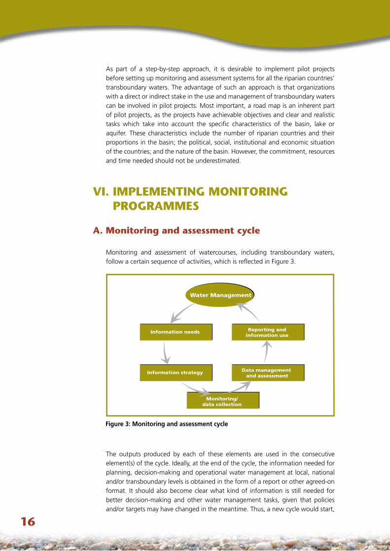
A. Monitoring and assessment cycle
Monitoring and assessment of watercourses, including transboundary waters, follow a certain sequence of activities, which is reflected in Figure 3.
The outputs produced by each of these elements are used in the consecutive element(s) of the cycle. Ideally, at the end of the cycle, the information needed for planning, decision-making and operational water management at local, national and/or transboundary levels is obtained in the form of a report or other agreed-on format. It should also become clear what kind of information is still needed for better decision-making and other water management tasks, given that policies and/or targets may have changed in the meantime. Thus, a new cycle would start,
Water Management
Information needs
Information strategy
Reporting andinformation use
Data management and assessment
Monitoring/data collection
Figure 3: Monitoring and assessment cycle
��
leading to redefined or fine-tuned information needs, an “upgraded” information strategy, and so on.
B. Information needs
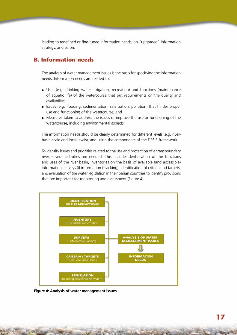
The analysis of water management issues is the basis for specifying the information needs. Information needs are related to:
Uses (e.g. drinking water, irrigation, recreation) and functions (maintenance of aquatic life) of the watercourse that put requirements on the quality and availability; Issues (e.g. flooding, sedimentation, salinization, pollution) that hinder proper use and functioning of the watercourse; andMeasures taken to address the issues or improve the use or functioning of the watercourse, including environmental aspects.
The information needs should be clearly determined for different levels (e.g. river-basin-scale and local levels), and using the components of the DPSIR framework.
To identify issues and priorities related to the use and protection of a transboundary river, several activities are needed. This include identification of the functions and uses of the river basin, inventories on the basis of available (and accessible) information, surveys (if information is lacking), identification of criteria and targets, and evaluation of the water legislation in the riparian countries to identify provisions that are important for monitoring and assessment (Figure 4).
●
●
●
CRITERIA / TARGETSfunctions uses issues
IDENTIFICATIONOF USES/FUNCTIONS
SURVEYSif information lacking
INVENTORYof available information
ANALYSIS OF WATER MANAGEMENT ISSUES
INFORMATIONNEEDS
LEGISLATIONincluding classification system
Figure 4: Analysis of water management issues
��
To specify information needs, information users and producers should interact closely. The institutions responsible for the protection and use of the transboundary watercourses, especially joint bodies, should be involved in the process of identifying and specifying information needs. Information needs have to be specified to such an extent that proper design criteria for the monitoring and assessment system can be derived. The information needs should be based on identified management issues and the decision-making process in river basin management.
Inventories of available information should bring together information that may, while available, be incoherent and distributed among different agencies/institutions. This includes not only the listing of information available from historical data, licenses and the like in administrative databases, but also a general screening and interpretation of all information relevant to the aspects under consideration.
Inventories should cover the major aspects that are relevant to the identification of the issues. These include, for example, water uses and water needs in the river basin; run-off characteristics and the probability of flood waves and ice drifts in the river basin; declines in groundwater levels; water quality; and, most important, sources of pollution from industries and municipal waste (especially the “hot spots”). These should be characterized in terms of, for example, production process, pollution composition and discharge load, land uses, and diffuse pollution sources with a register on the use of fertilizers and pesticides in agriculture. Other sources of pollution may include traffic and airborne pollution (which sometimes cause acid deposition), potential sources of accidental pollution such as pipelines, and other existing point pollution sources (e.g. uncontrolled waste disposal sites). The sources may also include ore and salt deposits, which are responsible for a certain “background” due to geophysical and geochemical processes.
Surveys will be needed if the inventory does not provide sufficient data. Water-quality surveys are intended to give a first insight into the functioning of the aquatic ecosystem and the occurrence of pollution and toxic effects in the water. Investigating the qualitative and quantitative structure of the biocoenose concerned makes it possible to assess the ecological status of a river, lake or estuary. Chemical screening of surface water, groundwater, sediments and effluents at hot spots and key locations can be performed. Additionally, specific target compounds that might be expected according to the inventory can be analysed. Toxic effects in surface water, sediments and effluents can be investigated at these locations. Surveys of water uses may also be required.
Information needs should be further specified so as to be able to design a monitoring and assessment programme. The specified information needs should at least lead to:
Appropriate variables to be monitored; Criteria for assessment (e.g. indicators, early warning criteria for floods or accidental pollution); Specified requirements for reporting and presenting information (e.g. presentation in maps, GIS, degree of aggregation); Relevant accuracy for each monitoring variable;
●
●
●
●
��
Degree of data rel iability;Specified response time (i.e. the period of time within which the information is needed), for example, for flood forecasts or early warning systems (e.g. minutes/hours), for trend detection (e.g. number of weeks after sampling) and other tasks.
The relevant accuracy and the degree of data reliability are decisive factors in the selection of monitoring sites, the determination of monitoring frequencies and the choice of laboratory technology and methodologies for data management.
Information needs should be prioritized. Information is mostly needed on high-priority issues. If the same information need arises from a variety of water management problems, this information need should be given high priority, because collecting this information once makes it possible to address a variety of issues.
c. Information strategy
After information needs have been identified, specified and prioritized, an information strategy should be developed. This defines the best practical way of gathering data from various sources: from the monitoring network, from expert judgments, from statistical publications and the bookshelves of various institutions. The information strategy should culminate in a monitoring plan and a plan for gathering data from other sources.
The information strategy needs to be adapted over time, as water management develops, targets are attained or policies have changed. However, it should be recognized that there is a need for continuity in order to produce time series that make it possible to detect significant and reliable trends. Environmental monitoring programmes should always be seen as requiring long-term commitment.
D. Monitoring/data collection
The most resource- and labour-intensive phase in monitoring is the one that includes sampling, in situ physico-chemical analysis and water-quantity-related measurements, and laboratory analysis. This phase also entails high risks in producing reliable and accurate data. Therefore, it is important to employ qualified and experienced personnel and comply with guidelines and standards.
The main monitoring objectives for rivers, lakes and groundwaters as well as effluents are to generate information, to be used both in national and transboundary contexts, for:
Assessing the actual status of water resources;Detecting possible long-term trends in water levels or pollutant concentrations; Providing for hydrological forecasts;Assessing pollution loads from point and non-point sources; Testing for compliance with permits for water withdrawal or discharges of wastewater and establishing taxes, fines and sanctions;
●
●
●
●
●
●
●
�0
Verifying the effectiveness of policy measures;Contributing to reporting on the state of the environment;Providing early warning to protect the intended water uses in the event of flooding or accidental pollution; Recognizing and understanding processes in water and water-related ecosystems (e.g. flow regime, erosion patterns, hydrobiological processes, natural or background pollution of water bodies);Enabling assessment of imminent or possible health risks and supporting predic-tions of long-term processes, which may have health-relevant outcomes; andRevising, if appropriate, the existing monitoring and assessment activities, including the existing monitoring network.
Each of these objectives may require specific measurement devices or sampling procedures, which are explained in detail in the large body of literature on these subjects.
VII. MANAGING DATA AND MAKING ASSESSMENTS
A. Data management
It is of utmost importance that policy makers and planners better understand the various steps in data management. This will facilitate data exchange among the institutions undertaking the monitoring and assessment, including joint bodies. To safeguard the future uses of the data that have been collected, the following steps are required before assessments can be made.
Developing a data dictionary
To facilitate the comparability of data, clear agreements should be made between the neighbouring countries on the coding of collected data and supporting information. Collected data for a given instance include the date, location, depth and measured values. Supporting information includes information about characteristics of the location, the type of sample and the type of measurement or sampling installation, any preconditioning procedures and analytical techniques, including detection limits. A data dictionary explaining the coding and defining terms should be prepared and agreed on.
Data validation
Data validation is an intrinsic part of data management and includes regular checking and control of newly collected data (detection of outliers, missing values and other obvious mistakes). Computer programmes are available to perform various control functions, but expert judgment and local knowledge of the water systems are also indispensable for validation. When the data have been thoroughly checked and any necessary corrections or additions made, they can be approved and made accessible.
●
●
●
●
●
●
��
Data storage
To be available for future use, data should be stored in databases. The dimensions and units should always be included. Enough supporting information to enable interpretation and reporting should also be stored. This supporting information is often referred to as meta-information. The database should have safeguards against the entering of data without supporting meta-information.
Managing data from multiple sources
Management of data from multiple sources (monitoring datasets, maps, land-use characteristics, satellite imagery, socio-economic data) is not easy and requires computers and suitable software. In particular, simulation models and GIS support the integrated management of data. Given that different concepts for databases may be used, at least compatible interfaces should be developed.
Data exchange
Formats for the exchange of data should be defined and agreed by the users. The data dictionary should be the basis for defining such formats.
The data storage systems in the neighbouring countries need to be able to handle the agreed data exchange formats and allow the data to be imported into modelling or statistical software. For storage of data on transboundary watercourses, the relevant joint body may consider the establishment of a central system. The guidelines for data exchange developed by EUROWATERNET may be suitable for supporting such activities.35
Data analysis and interpretation
The conversion of data into information involves analysis and interpretation. Data analysis should be embedded in a data analysis protocol (DAP) which clearly describes how the data should be analysed and interpreted and what should be done in case of missing data, outliers, non-normality and serial correlation.
The data analysis may be largely a statistical operation or set of operations using generic software packages. Statistical techniques may be used to detect trends and trend reversals and test for compliance with standards. The use of tailor-made adaptations to the software may be desirable. The DAP should therefore include procedures for processing the monitoring data to meet the specific interpretation needs (for example, calculations based on individual measurements or yearly averages, single sites or averages for the whole water body).
The DAP should be extended to reporting formats for the resulting information. Thus, the DAP should specify the format of the report, the frequency of publication, the intended audience, distribution procedures and the types of conclusions to be drawn and represented.
35 http://dd.eionet.eu.int/index.jsp
��
B. Assessment methodology
The assessment methodology will determine or at least influence the design of the monitoring programme. Therefore, it should be drawn up in parallel with undertaking an analysis of information needs and designing the monitoring programme.
Given the purposes of assessments, a simple way of using monitoring results is based on certain key variables and indicators. Especially in cases where binding water protection targets for certain pollutants, like pesticides, have been expressed by numerical norms or standards, comparing the state of the watercourses with them is a straightforward task and can be done in a very early phase. Another simple yet informative method of assessment is to prepare maps of the distribution of the monitored determinands for certain larger water areas. Such an assessment is particularly appealing and understandable for laypeople.
In monitoring programmes, where large amounts of different data are collected continuously over several years, statistical methods are needed to effectively summarize the results of monitoring. In particular, different types of trend calculations are being used to assess monitoring data. In interpreting trends in water quality, particular attention should be paid to water-quantity data, since hydrology strongly affects water quality.
The use of water classification systems to assess watercourses is very common. Some of these systems are based on physico-chemical variables, but biological approaches (such as ecological classification under the WFD) are also used. For transboundary water assessments, whether based on classification systems or on other assessment methods, it is important to strive for comparability of results rather than unification of methods.
VIII. REPORTING AND USING INFORMATION
A. Reporting
Reporting is another essential step in the monitoring and assessment cycle. Reporting has a key role for decision-making in water management and in further development of monitoring and assessment programmes. Reports should be prepared on a regular basis. The main issue is to present the interpreted data in an easily accessible and understandable way tailored to the audience being addressed.
Reporting obligations
Environmental information should be public, according to the Aarhus Convention and Directive 2003/4/EC36 on public access to environmental information. This has
36 http://europa.eu.int/eur-lex/pri/en/oj/dat/2003/l_041/l_04120030214en00260032.pdf
an especially important role in increasing public awareness of water problems and public participation in water management.
An inventory should be made of national and international reporting obligations so as to be able to fulfil reporting requirements laid down in national water management legislation, applicable transboundary agreements and EU Directives as well as relevant decisions taken in international forums. The Reporting Obligations Database37 developed by the European Environment Agency includes an overview of many international reporting obligations.
Reporting formats and audiences
The level of detail included in the reports and the frequency of compilation also depend on the target audience. The content of the report should be targeted at the needs of an audience that includes international bodies, management and scientific institutions, national administrations and the public. Depending on the needs of the target group, the report contains aggregated information (e.g. indicators) and/or detailed information in tables, statistically processed data, graphs and geographically presented information.
Public authorities, including joint bodies, usually request information in a specific format and frequency, which are defined in reporting protocols or reporting schemes. Such reports are usually presented in writing to ensure unambiguous understanding of the results. In addition, public authorities may have ad hoc requests for information which are not predefined in reporting protocols but are related to specific current topics in water management. This kind of reporting has to meet strict requirements concerning response time and flexibility.
Reporting to the public usually follows an ad hoc request for information and can hardly be predefined in reporting protocols. Guidance is provided in the Aarhus Convention and in the EU Guidelines on public participation in water management.38
A state-of-the-environment report should provide concise information for decision-making in water management. These reports typically provide information on the state and functions of the water body, describe the existing problems and the pressure they put on the water body, and give insight into the impacts of corrective measures. Their decision-making value is strongly increased by using visualization tools and indicators, in particular if the elements of the DPSIR framework are reported.
37 http://rod.eionet.europa.eu/index.html38 http://forum.europa.eu.int/Public/irc/env/wfd/library?l=/framework_directive/guidance_documents/
guidancesnos8spublicspar/_EN_1.0_&a=d
��
����
The form of a joint report for the purposes of water management in transboundary basins should be agreed upon in detail by the riparian countries. Harmonization of reporting is strongly encouraged. Joint reporting naturally requires a high level of data comparability. The reports should highlight the links between policy measures and the status of the water body of concern. Periodic assessments under the Water Convention, covering all transboundary water basins in the region, are also recommended (at regular intervals of, say, three years) to encourage the evaluation of progress made under the Convention, stimulate the commitment of the members involved, and make results available to the public.
The Internet provides a powerful tool for sharing and communicating information and can be used to inform and involve the public. Traditionally, authorities have been very cautious in presenting environmental information and data to the public because of the risk of misinterpretation of information by laypeople. However, involving non-governmental organizations and the public in transboundary water management promotes awareness and stimulates more sustainable cooperation between countries.
B. Information use
The information produced must be used and should contribute to management decisions. Therefore, the information products in their various forms need to be made accessible and attractive to users. These products should convey the messages that the information users really need.
The information product should be based on the information needs as specified. In particular, the information should be clearly linked to the relevant components of the DPSIR framework. While much of the information derived from a monitoring programme has its most direct link to the status of transboundary waters, interpretation and assessment in relation to the drivers and pressures and how these are changing over time, and in relation to impacts on (for example) the health of water users, must be included. Information products specifically related to responses – for example, the effectiveness of measures to protect or restore – are required by water managers. The information product should consequently address the full range of the DPSIR framework, thereby enabling decision-making about future actions and measures.
Given the monitoring and assessment cycle, the use of the information should also feed back into the design of monitoring and assessment. This may lead to revision and improvement of the monitoring programme, as well as review of and possibly changes in the information needs and the consequent priorities for monitoring and assessment, including reviewing the most effective use of the available funding. While the monitoring and assessment programme needs stability and continuity to meet information needs, the specific activities that make up the monitoring and assessment cycle should be flexible enough to suit changing drivers and pressures, new legal requirements and obligations, and otherwise changing conditions. The monitoring and assessment cycle should, therefore, be seen as a continuously evolving, gradually improving spiral.

UNITED NATIONSUNITED NATIONS
STRATEGIES FOR MONITORING
AND ASSESSMENT
OF TRANSBOUNDARY RIVERS,
LAKES AND
GROUNDWATERS
E C O N O M I C C O M M I S S I O N F O R E U R O P E
Convention on the Protection and Use of Transboundary Watercourses and International Lakes
Water Convention secretariatUnited Nations Economic Commission for Europe
Palais des Nations
CH-1211 Geneva 10, Switzerland
Tel.: +41 (0)22 917 2463
Fax: +41 (0)22 917 0107
E-mail: [email protected]
Web site:http://www.unece.org/env/water/
UNECE Environment, Housing and Land Management DivisionFax: +41 (0)22 917 01 07
E-mail: [email protected]
Web site: http://www.unece.org/env/
UNECE Information UnitTel.: +41 (0)22 917 4444
Fax: +41 (0)22 917 0505
E-mail: [email protected]
Web site: http://www.unece.org
Printed at United Nations GE.06-25752–October 2006–2,215
ECE/MP.WAT/20
Unites Nations Publication Sales No. E.06.II.E.15 ISBN 92-1-116951-8


![Adopting a Strategic Framework for Transboundary Water ... · Some tensions on these transboundary rivers have been reported by Favre and Kamal [2004] and King and Sturtewagen [2010]](https://img.pdfslide.us/doc/110x75/5ebed6d47728994fa825c608/adopting-a-strategic-framework-for-transboundary-water-some-tensions-on-these.jpg)


![2007 Volume II - legal.un.org · 1 ShAREd NATuRAl RESOuRCES [Agenda item 2] dOCumENT A/CN.4/580 Fourth report on shared natural resources: transboundary groundwaters, by mr. Chusei](https://img.pdfslide.us/doc/110x75/5fc87c7cf6732727c5069083/2007-volume-ii-legalunorg-1-shared-natural-resources-agenda-item-2-document.jpg)