Embed Size (px)
Citation preview
by Timothy J. Walsh and Recep Cakir
WASHINGTON DIVISION OF GEOLOGY
AND EARTH RESOURCES
June 24, 2013
This report has not been edited or reviewed for conformity with Division of Geology and Earth Resources
standards or geologic nomenclature
STRATEGIES FOR ESTABLISHING A
WASHINGTON STATE POST-EARTHQUAKE INFORMATION
CLEARINGHOUSE:
A REPORT TO THE WASHINGTON EMERGENCY MANAGEMENT
DIVISION
R
E
S
O
U
R
C
E
S
N
A
T
U
R
A
L

STRATEGIES FOR ESTABLISHING A WASHINGTON STATE POST-EARTHQUAKE
INFORMATION CLEARINGHOUSE:
A REPORT TO THE WASHINGTON EMERGENCY MANAGEMENT DIVISION
by Timothy J. Walsh and Recep Cakir
WASHINGTON DIVISION OF GEOLOGY
AND EARTH RESOURCES
June 24, 2013
This report has not been edited or reviewed for conformity
with Division of Geology and Earth Resources standards or geologic nomenclature
DISCLAIMER Neither the State of Washington, nor any agency thereof, nor any of their employees, makes any warranty, express or implied, or assumes any legal liability or responsibility for the accuracy, completeness, or usefulness of any information, apparatus, product, or process disclosed, or represents that its use would not infringe privately owned rights. Reference herein to any specific commercial product, process, or service by trade name, trademark, manufacturer, or otherwise, does not necessarily constitute or imply its endorsement, recommendation, or favoring by the State of Washington or any agency thereof. The views and opinions of authors expressed herein do not necessarily state or reflect those of the State of Washington or any agency thereof. WASHINGTON STATE DEPARTMENT OF NATURAL RESOURCES Peter Goldmark—Commissioner of Public Lands DIVISION OF GEOLOGY AND EARTH RESOURCES David K. Norman—State Geologist John P. Bromley—Assistant State Geologist Washington State Department of Natural Resources Division of Geology and Earth Resources Mailing Address: Street Address: MS 47007 Natural Resources Bldg, Rm 148 Olympia, WA 98504-7007 1111 Washington St SE Olympia, WA 98501 Phone:360-902-1450 Fax: 360-902-1785 E-mail: [email protected] Website: http://www.dnr.wa.gov/geology Publications List: http://www.dnr.wa.gov/ResearchScience/Topics/GeologyPublicationsLibrary/Pages/pubs.aspx Washington Geology Library Catalog: http://www.dnr.wa.gov/ResearchScience/Topics/GeologyPublicationsLibrary/Pages/washbib.aspx Washington State Geologic Information Portal: http://www.dnr.wa.gov/geologyportal Published in the United States of America © 2013 Washington Division of Geology and Earth Resources
Strategies for Establishing a Washington State Post-Earthquake Information Clearinghouse: A Report to the Washington Emergency Management Division by Timothy J. Walsh and Recep Cakir
INTRODUCTION
After a significant earthquake, professionals in many disciplines and interested volunteers gather various kinds of information about the effects of the earthquake on people and on the built and natural environments. Earthquake clearinghouses are commonly established to coordinate their data gathering efforts and create a repository for the observations and analyses. The size and impacts of the earthquake determine the size and complexity of these investigations and the need for coordination. A Cascadia subduction zone earthquake (M~9), for instance, will cause damage and injuries in Washington, Oregon, California, and British Columbia, and its tsunami can have impacts as far away as Japan. The February 2001 Nisqually earthquake, on the other hand, caused physical damage only within the state of Washington, although it triggered a Federal Disaster Declaration that engaged multiple federal agencies in the response. An ad hoc clearinghouse was established for this event but did not fully coordinate with the emergency management community in the first few days after the event, and some perishable data were lost.
In 2007, the Washington Department of Natural Resources, Division of Geology and Earth Resources (DGER) and the Washington Military Department, Emergency Management Division (EMD) began planning for a permanent clearinghouse. We made agreements with state and federal agencies and with professional organizations, and prepared a draft document (Appendix). We attempted to exercise it, which exposed some technical and logistical flaws. Attempts to secure funding to revise, train, and exercise the clearinghouse plan were unsuccessful and our clearinghouse plan has lapsed. Since then, other clearinghouse models have emerged and there have been significant advances in communication/information technology as well. In this document we will review both ad hoc and permanent clearinghouses, their funding, staffing, organization, training and exercising, technical means of gathering and disseminating data, timeliness, and the target audience for the information.
REVIEW OF OTHER STATE AND NATIONAL CLEARINGHOUSES
In this section we offer a brief description of clearinghouses: the 2007 Washington plan, Utah Geological Survey Earthquake Clearinghouse, Wells Nevada Earthquake Technical Clearinghouse, the Earthquake Engineering Research Institute (EERI), U.S. Geological Survey (USGS), and Geotechnical Extreme Events Reconnaissance (GEER), and the California Earthquake Clearinghouse.
Washington
After the Nisqually earthquake in February, 2001, responders and researchers operated with little high level coordination for several days. Tim Walsh at Washington Division of Geology and Earth Resources and Tom Pratt of the USGS coordinated geologic and geotechnical investigations of their own agencies as well as could be done with limited cell phone access. Field investigators were asked to call in to the state Emergency Operations Center or the USGS office at the University of Washington (UW) for guidance. After a few days, Steve Kramer and Marc Eberhard of the University of Washington organized nightly
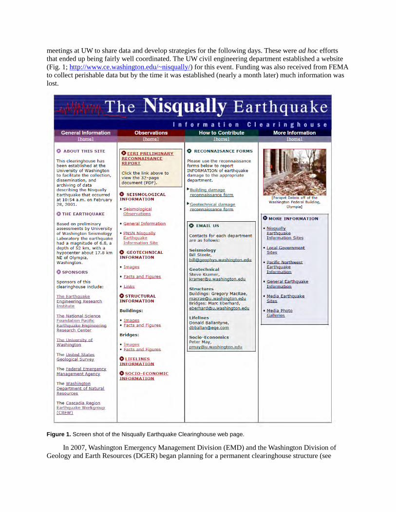
meetings at UW to share data and develop strategies for the following days. These were ad hoc efforts that ended up being fairly well coordinated. The UW civil engineering department established a website (Fig. 1; http://www.ce.washington.edu/~nisqually/) for this event. Funding was also received from FEMA to collect perishable data but by the time it was established (nearly a month later) much information was lost.
Figure 1. Screen shot of the Nisqually Earthquake Clearinghouse web page.
In 2007, Washington Emergency Management Division (EMD) and the Washington Division of Geology and Earth Resources (DGER) began planning for a permanent clearinghouse structure (see
appendix for full text). We made agreements with other state agencies, professional societies, EERI, and the USGS to coordinate and share resources. DGER also tested such a common ground using the Department of Information Services (DIS) (now called Department of Enterprise Services) external Microsoft SharePoint site (a secure place to store, organize, share, and access information from almost any device). Although SharePoint software provided many valuable tools to run an earthquake clearinghouse, it was very difficult to include key responders (such as researchers from universities) and maintain the password changes due to the strict DIS security policies. Also, DIS required continuing funding for the use of disk space (~$50/2GB/Month). This could make the clearinghouse effort extremely expensive after a disaster event if a secure funding mechanism were not obtained, because of the multiple terabytes of information (movies, photos, maps, etc.) storage requirements. (We are also not sure if the DIS current policies and standards are compatible with all the requirements—such as DIS SharePoint does not accept all table forms or formatted forms, etc. It may only accept, for example, Excel .xls but not .xlsx format. We established a password-protected Sharepoint for investigators to upload data, and performed some pilot projects to test the data transfer protocols. These were not entirely successful, and our attempts to acquire grant funding to modify test, and train these protocols were not successful.
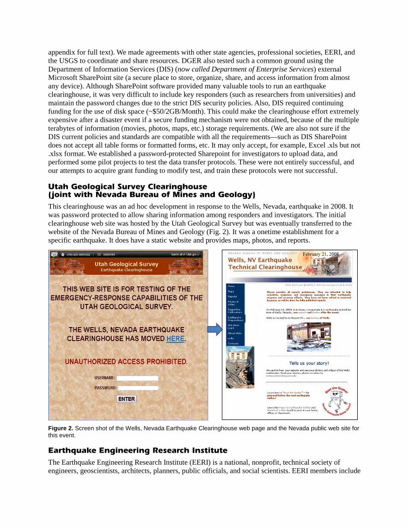
Utah Geological Survey Clearinghouse (joint with Nevada Bureau of Mines and Geology)
This clearinghouse was an ad hoc development in response to the Wells, Nevada, earthquake in 2008. It was password protected to allow sharing information among responders and investigators. The initial clearinghouse web site was hosted by the Utah Geological Survey but was eventually transferred to the website of the Nevada Bureau of Mines and Geology (Fig. 2). It was a onetime establishment for a specific earthquake. It does have a static website and provides maps, photos, and reports.
Figure 2. Screen shot of the Wells, Nevada Earthquake Clearinghouse web page and the Nevada public web site for this event.
Earthquake Engineering Research Institute
The Earthquake Engineering Research Institute (EERI) is a national, nonprofit, technical society of engineers, geoscientists, architects, planners, public officials, and social scientists. EERI members include
researchers, practicing professionals, educators, government officials, and building code regulators. It is supported by dues but also receives funding from the National Science Foundation and the U.S. Geological Survey. One of its principal programs is Learning From Earthquakes (LFE). This program, which has been funded in large part by the U.S. National Science Foundation, sends out multi-disciplinary teams of researchers (e.g., earth scientists, engineers, social scientists) into the field to investigate and to learn from the damaging effects of earthquakes. The reconnaissance team makes a rapid, general damage survey of the affected area, documents initial important observations from the particular earthquake, and assesses the need for follow-up areas of research. These teams are supported by a range of agencies and organizations, including the Pacific Earthquake Engineering Center, the Network for Earthquake Engineering Simulation (NEES) and EERI subscribing member firms, with substantial support coming from the U.S. National Science Foundation. The newest partner to support EERI’s program is the Global Facility for Disaster Risk Reduction (GFDRR) of the World Bank, which will support teams to damaging, important earthquakes in developing countries. The LFE program is managed by an EERI committee, currently chaired by Professor Jack Moehle, University of California, Berkeley (from the EERI website). EERI provides a post-earthquake investigation field guide (EERI, 1996), all forms for data collection and can provide a login ID to upload data and photographs to their website. For many, though not all earthquakes investigated, EERI establishes virtual clearinghouses (http://www.eqclearinghouse.org/). Current active clearinghouse websites are:
Mw 6.0 – Emilia Italy Clearinghouse Website
Mw 7.2 – Eastern Turkey, Clearinghouse Website
Mw 5.8 – Virginia, USA Clearinghouse Website
Mw 9.0 – Tohoku, Japan Clearinghouse Website
Mw 6.3 – Christchurch, New Zealand Clearinghouse Website
Mw 7.1 – Canterbury, New Zealand 2010-09-03 Clearinghouse Website
Mw 7.2 – Baja Earthquake 2010-04-04 Clearinghouse Website
Mw 8.8 – Chile Earthquake 2010-02-27 Clearinghouse Website
Mw 7.0 – Haiti Earthquake 2010-01-12 Clearinghouse Website
Mw 6.5 – Eureka Earthquake 2010-01-10 Clearinghouse Website
Mw 7.6 – Padang Earthquake 2009-09-30 Clearinghouse Website
Mw. 8.0 – Samoa Earthquake 2009-09-29 Clearinghouse Website
Mw 6.3 – L’Aquila, Italy Earthquake 2009-04-06 Clearinghouse Website
These sites compile information on engineering, geotechnical, social, economic, and emergency management impacts of these earthquakes. They are also investigating various smartphone applications for annotating and transmitting photographs. They have also created an action plan for collection and management of earthquake data (EERI, 2003).
EERI and the United States Geological Survey (USGS) share responsibility under a recently completed federal post-earthquake investigation plan (see under U.S. Geological Survey below) to manage reconnaissance efforts in the United States; EERI has primary responsibility in international earthquakes. Typically, management includes coordinating all field investigators. EERI has also forged a partnership with California, which will be described in the California section below.
U.S. Geological Survey
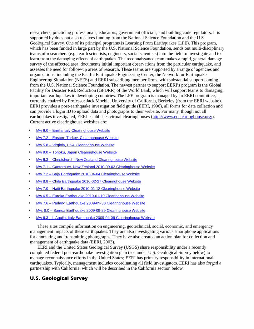
The USGS recently published a plan (Holzer and others, 2003) to coordinate post-earthquake investigations pursuant to the National Earthquake Hazards Reduction Program (NEHRP). NEHRP is a federal partnership of the USGS, the Federal Emergency Management Agency (FEMA), National Institute of Standards and Technology (NIST) and the National Science Foundation (NSF) as well as external partners funded through competitive grants. This plan lays out a timeline of significant actions to be taken following an earthquake, specifically calling for USGS, FEMA, and EERI to establish a clearinghouse within 24 hours, with participation as available from state and local agencies. The design and operation of the clearinghouse is left to the participants to establish, but deference is given to the state if there is an existing clearinghouse framework. The plan identifies three time frames, or phases, for action, and identifies specific activities associated with each phase (Fig. 3).
Figure 3. Activities timeline for NEHRP Post-Earthquake Coordination Plan for Domestic Earthquakes (from Holzer and others, 2003).
Geotechnical Extreme Events Reconnaissance (GEER)
GEER is an NSF-funded organization of professional scientists and engineers that prepares reconnaissance report and coordinates the researchers in/outside the U.S. The Objectives and Purposes of GEER are:
1. Document geotechnical engineering and related effects of important earthquakes and other disasters to advance research and practice.
2. Advance the capabilities of individuals performing post-event reconnaissance. 3. Employ innovative technologies for post-event reconnaissance. 4. Facilitate access to equipment required for sensing and data collection. 5. Train individuals to perform effective post-event reconnaissance. 6. Disseminate timely and accurate post-event web-based reports and data.
7. Develop a coordinated response for geotechnical engineers, engineering geologists, and earth scientists, who have previously self-assembled, to form effective post-event reconnaissance teams.
8. Promote the standardization of measurement and reporting in reconnaissance efforts.
GEER’s responsibilities include other natural disasters besides earthquakes. Its reconnaissance reports are published on-line at http://www.geerassociation.org/index.html
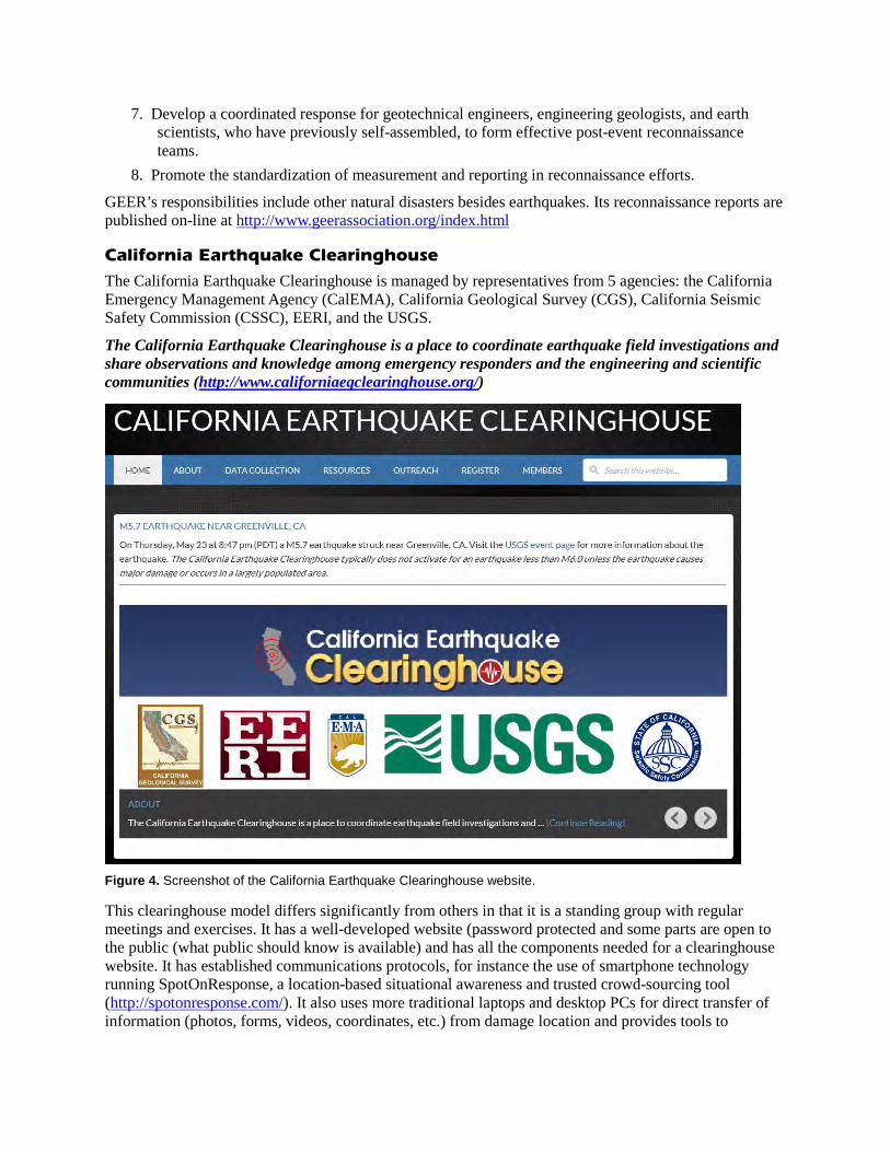
California Earthquake Clearinghouse The California Earthquake Clearinghouse is managed by representatives from 5 agencies: the California Emergency Management Agency (CalEMA), California Geological Survey (CGS), California Seismic Safety Commission (CSSC), EERI, and the USGS.
The California Earthquake Clearinghouse is a place to coordinate earthquake field investigations and share observations and knowledge among emergency responders and the engineering and scientific communities (http://www.californiaeqclearinghouse.org/)
Figure 4. Screenshot of the California Earthquake Clearinghouse website.
This clearinghouse model differs significantly from others in that it is a standing group with regular meetings and exercises. It has a well-developed website (password protected and some parts are open to the public (what public should know is available) and has all the components needed for a clearinghouse website. It has established communications protocols, for instance the use of smartphone technology running SpotOnResponse, a location-based situational awareness and trusted crowd-sourcing tool (http://spotonresponse.com/). It also uses more traditional laptops and desktop PCs for direct transfer of information (photos, forms, videos, coordinates, etc.) from damage location and provides tools to
responders. The forms are simplified and can be electronically uploaded over the smartphones, and are also provided in the static forms. It has established protocols using the Unified Incident Command & Decision Support (UICDS), an Information Sharing Technology Program from the Department of Homeland Security Science and Technology Directorate. UICDS “is a national middleware framework to enable information sharing and decision support among commercial, academic, volunteer, and government incident management technologies used across the country to prevent, protect, respond, and recover from natural, technological, and terrorist events. UICDS is designed around data standards and the National Information Exchange Model (NIEM) to support the National Response Framework (NRF) and the National Incident Management System (NIMS), including the Incident Command System (ICS), and provides the background information and connects the information available through the USGS, NASA, and other appropriate agencies.” (from the UICDS website, www.UICDS.us).
The UICDS regularly holds workshops using their available tools (web meetings, local workshops among the local responders, and connecting them to government agencies FEMA, USGS and NASA).
RECOMMENDATIONS FOR ESTABLISHMENT OF A WASHINGTON STATE CLEARINGHOUSE
The initial draft of the Washington clearinghouse plan (Appendix) identified the primary functions of the clearinghouse, through phases I and II of the USGS model. They are to:
1. collect and verify perishable reconnaissance information; 2. convey that information to the EOC; 3. serve as the “check-in” and “check-out” point for all researchers who arrive at the scene; 4. provide updated damage information to all investigators, through daily briefings and reports; 5. track where investigators are in the damaged area; and 6. introduce method into what is frequently haphazard by arranging for investigators to cover
areas not yet sufficiently reported on; the clearinghouse will channel researchers and observers toward the specific damaged areas where their expertise will be most valuable.
We have compiled a list of recommendations for a Washington State earthquake clearinghouse plan, many of which already exist in some form. Much of this is taken from the California Earthquake Clearinghouse model, which is the most well-developed and integrated with emergency management.
• Organizations and agencies participating in the clearinghouse should be identified in advance and sign on to a memorandum of agreement. Individuals within those organizations and agencies should be identified and their contact information kept in a database. This includes first responders as well as professional social and physical scientists and engineers, and volunteer organizations.
• A website should be established and maintained (similar to California Earthquake Clearinghouse,) covering all the components needed for a clearinghouse. This includes a calendar of events, training and exercising opportunities, data collection protocols, and software tools for acquiring and transmitting data. Additionally, we should solicit recommendations and offers from appropriate Washington State and federal agencies, as well as private sector firms to determine our best website-IT connections for a fast and robust information transfer, mapping and storage capacities. This may require a consultant.
• Use cell phone technology (such used in California – SpotOnResponse). Review other EERI suggestions for cell Apps (forms, transfer photos, information). Although the EERI shows various options, only one recommended smart phone application is free to use. SpotOnRepsonse has been specifically designed for an earthquake clearinghouse needs and operations, and tested with a few
exercises. After a series of exercises and workshops in California, this application has been developed and is open to more developments.
• Training and exercising are essential and should be conducted regularly. Large landslides, flood or storm events should be used to exercise the system using real events. Compared to California and Alaska, the number of damaging EQs in Washington is less, so to keep all clearinghouse developments up-to-date we need to use the same model (maybe with slight modifications) for landslides and storm/flood events.
• A good outreach program and an active staff moderating all the communications and setting up the meetings (online as well) are essential for recruitment as well as for obtaining useful feedback.
• Coordinate with the California Earthquake Clearinghouse for training and exercise opportunities and advice.
Flexibility will be important for maintenance of a clearinghouse. Software will change and new applications are continually being developed. The main initial need is for robust storage on the cloud out-of-area. It could be partitioned so that each professional society or agency can have a space to write to so we can have multiple passwords. Software packages can be recommended but the managers of the clearinghouse need to be able to translate a variety of formats, put data into ArcGIS, and quickly transmit to EMD for situational awareness.
Many of these steps require a secure funding source, both to develop and to maintain continuity. Significant steps to create a functional clearinghouse must await funding, but planning and coordinating with California can proceed and we can build on the previous version of the clearinghouse plan (Appendix).
REFERENCES
Earthquake Engineering Research Institute, 1996, Post-Earthquake Investigation Field Guide: EERI, 1996 p., [accessed May 6, 2013 at https://www.eeri.org/projects/learning-from-earthquakes-lfe/post-earthquake-investigation-field-guide/] Earthquake Engineering Research Institute, 2003, Collection and management of earthquake data: defining issues for an action plan: EERI, 118 p. [accessed May 6, 2013 at https://www.eeri.org/wp-content/uploads/Collection-MgmtEQData.pdf] Holzer, T. L.; Borcherdt, R. D.; Comartin, C. D.; Hanson, R. D.; Tierney, Kathleen; Youd, T. L., 2003, The Plan to Coordinate NEHRP Post-Earthquake Investigations: U.S. Geological Survey Circular 1242, 20 p.
APPENDIX
EMD-DGER POST-EARTHQUAKE TECHNICAL CLEARINGHOUSE
DRAFT
March 24, 2008
Division of Geology and Earth Resources
and
Washington Office of Emergency Management
INTRODUCTION
An earthquake disaster in Washington will attract a large number of earthquake professionals with the intent to learn lessons and lend assistance. These visitors are researchers, engineers, seismologists, geologists, and representatives of organizations concerned with seismic safety. They have a wide range of knowledge and experience, and their observations in the field can add substantially to the information available to officials managing response and recovery operations. However, without a plan for coordinating their reconnaissance activities and integrating their findings into emergency management, their efforts will not be directly useful in response, damage assessment, and early recovery activities. Furthermore, their deployment should be coordinated so that their presence benefits rather than burdens local officials in affected cities and counties. Additionally, a forum for the daily sharing of the information gathered by all observers allows for the capture of much valuable and perishable data that may otherwise be lost to both the government and research communities.
To coordinate the gathering of information, maximize its availability, and better use the talents of those present, a clearinghouse operation is necessary. This plan outlines the purposes to be served, the management and participants, and the operations of the clearinghouse. The plan is adapted from the California Post-Earthquake Information Clearinghouse draft plan, and includes sections taken from that plan with little modification.
PLANS AND INTELLIGENCE
The clearinghouse is intended to facilitate exchange of critical information from field investigations, and to promote its use by technical specialists and emergency managers during response and recovery from damaging earthquakes. The clearinghouse will provide a single point of contact for easy exchange of information among researchers, emergency managers, and practitioners. It will direct information to the State Emergency Operations Center (EOC). It will accommodate investigators from other states and countries, and provide a contact for media to use in gathering more in-depth information on damages and their implications.
The clearinghouse will allow for a more coherent and methodical investigation of all earthquake impacts, the gathering of perishable data, and the tracking of all field investigations. It will help ensure
that all areas have been thoroughly explored, and that optimum value is derived from technical personnel provided by other WSSPC states.
Further, it will make possible the documentation of findings and observations. A record of field observations will be displayed in the clearinghouse, but we do not plan a Geographic Information System (GIS) capability at the clearinghouse. Agencies responsible for mapping of geologic, geotechnical, and engineering effects of the earthquake will use their internal GIS capabilities to document effects, and make them available at the clearinghouse as necessary. A state GIS capability may be available to the clearinghouse through the Department of Natural Resources, but personnel will not necessarily be located at the clearinghouse.
MANAGEMENT
The Division of Geology and Earth Resources (DGER) will request the Washington Emergency Management Division (EMD) and Department of Natural Resources (DNR) to identify a facility for the clearinghouse, and work with them to get it established based on pre-arranged cooperative agreements. Clearinghouse management will be through a team of representatives of the DGER, OEM, U.S. Geological Survey (USGS), Earthquake Engineering Research Institute (EERI), and the Washington Seismic Safety Commission (WSSC). Clearinghouse staff will be flexible in numbers and duties, but at least two positions will be designated: 1) director, and 2) staff coordinator. Both will initially be DGER employees to get the clearinghouse up and running, but once the management team assembles, they will designate a permanent director and identify additional staff as needed. We anticipate that the DGER will supervise its field operations from the clearinghouse, so the DGER field-operations supervisor will act as initial clearinghouse director. The clearinghouse director will provide a technical contact for visiting professionals, and administratively oversee clearinghouse operations. The director will conduct the nightly briefings. The staff coordinator will oversee clearinghouse logistics and office operations, including acquiring equipment and making it operational, providing assistance to clearinghouse users, coordinating activities, overseeing establishment of a website and link with the EOC and DFO, supervising clearinghouse staff, and ensuring that information is widely disseminated.
The director will deal with media representatives and set ground rules for their presence at daily clearinghouse briefings. Media representatives can attend briefings, but not ask questions during the briefings. Following the briefings, media representatives can speak with the investigators who indicated they were available for further discussions.
Organizations that will be active in, and support the work of, the clearinghouse are: Washington Division of Geology and Earth Resources (DGER) Washington Emergency Management Division (EMD) Washington Seismic Safety Committee (WSSC) Pacific Northwest Seismic Network (PNSN) Earthquake Engineering Research Institute (EERI) Federal Emergency Management Agency, Region X (FEMA X) Washington Department of Transportation Washington Department of Ecology Washington Department of Health
Washington State Patrol (Washington Department of Natural Resources (DNR) is substituted as a place holder.
Washington does not have a Division of Construction and Management. It appears California’s DFCM is responsible for procurement of facilities and assists in engineering evaluations. We need to decide who gets this job.)
Structural Engineers Association of Washington (SEAW) American Society of Civil Engineers (ASCE) Seattle-Geotechnical Group U.S. Geological Survey (USGS) Western States Seismic Policy Council (WSSPC)
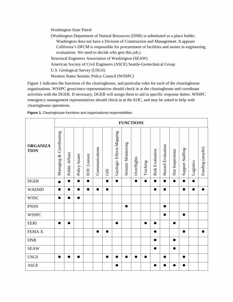
Figure 1 indicates the functions of the clearinghouse, and particular roles for each of the clearinghouse organizations. WSSPC geoscience representatives should check in at the clearinghouse and coordinate activities with the DGER. If necessary, DGER will assign them to aid in specific response duties. WSSPC emergency management representatives should check in at the EOC, and may be asked to help with clearinghouse operations.
Figure 1. Clearinghouse functions and organizational responsibilities.
ORGANIZATION
FUNCTIONS
Man
agin
g &
Coo
rdin
atin
g
Publ
ic A
ffai
rs
Polic
y Is
sues
EOC
Lia
ison
Com
mun
icat
ions
GIS
Geo
logi
c Ef
fect
s Map
ping
Seis
mic
Mon
itorin
g
Ove
rflig
hts
Trac
king
Ris
k Ev
alua
tion
Haz
ard
Eval
uatio
n
Site
Insp
ectio
ns
Supp
ort S
taff
ing
Logi
stic
s
Fund
ing
(may
be)
DGER
WAEMD
WSSC
PNSN
WSSPC
EERI
FEMA X
DNR
SEAW
USGS
ASCE
Other research institutions, professional organizations, and out-of-state agencies may take part in the clearinghouse activities; their participation will be determined by the location and the impacts of the earthquake in question. The EERI Post-Earthquake Response Team will be a valuable resource because of their expertise and experience in post-earthquake response, and we anticipate the Team will play an active role in clearinghouse briefings and operations.
OPERATIONS
The primary functions of the clearinghouse will be to 1) collect and verify perishable reconnaissance information; 2) convey that information to the EOC; 3) serve as the “check-in” and “check-out” point for all researchers who arrive at the scene; 4) provide updated damage information to all investigators, through daily briefings and reports; 5) track where investigators are in the damaged area; and 6) introduce method into what is frequently haphazard by arranging for investigators to cover areas not yet sufficiently reported on. The clearinghouse will channel researchers and observers toward the specific damaged areas where their expertise will be most valuable. Arrangements for access into secured areas will be facilitated by the clearinghouse through provision of letters of passage, badges, and contacts with local governments. All researchers requesting letters of passage will sign in with the clearinghouse staff coordinator, and be asked to observe certain protocols with respect to local emergency managers and residents. No credentials will be supplied by the clearinghouse, but WSSPC will identify and provide credentials to out-of-state WSSPC representatives that are available to assist.
A. Thresholds for Activation
The clearinghouse will be put into operation at the discretion of the Clearinghouse Management Team. An earthquake in an urban area will trigger clearinghouse establishment when it is damaging and/or has a magnitude of 5.5 or above. In cases of relatively small or rural earthquakes where emergency response activities are limited, the clearinghouse may still be activated mainly to coordinate geoscience activities.
The clearinghouse may be established upon recommendation of initial field investigators from DGER and EMD staff deployed to survey the earthquake impacts. A federal disaster declaration is not necessary to activate the clearinghouse, but the clearinghouse will always be activated when there is a federal disaster declaration.
B. Timing
Since the clearinghouse should be operating by the time the first reconnaissance organization or agency arrives on the scene, it is critical to get it operational within 24 hours of the earthquake.
The duration of clearinghouse operation is dependent on the magnitude of the damage and extent of the response and early recovery periods. Clearinghouse operations can be reduced when the need for reconnaissance decreases. Termination will occur after most perishable damage information has been gathered and detailed studies begin.
C. Location and notification The clearinghouse should be as close to the affected area as possible, while still providing space and support services necessary. (Is the compound at the airport centrally located enough for all western
Washington events? Should an eastern Washington location be designated? Does this mean we need a portable clearinghouse? Also, is it big enough?) It should be located such that it affords access to the state or local EOC, although physical proximity may not be as important as electronic connectivity.
For contact and intelligence sharing with safety assessment personnel, the clearinghouse is ideally located proximate to the EOC, which may be a field (local) EOC for earthquakes remote from the State Capitol. Though it will not be located in the EOC, it should be sited so that traffic and communication between it and the EOC is relatively easy to accomplish. The space should be chosen in recognition of the fact that the clearinghouse operation requires electricity, phones, fax machines, copiers, and working and display space. A meeting room large enough for convening a group of a minimum of 50 people is necessary. Lastly, the clearinghouse location should be close enough to the affected area to permit relatively easy access.
DGER will notify the WSSPC home office of the clearinghouse location as soon as it is established. WSSPC will post it on their website and forward the information to WSSPC states interested in sending representatives.
D. Relationship to EOC/DFO
The clearinghouse will supplement the intelligence-gathering and damage assessment activities of the EOC. Every evening the clearinghouse will hold a reconnaissance briefing, during which researchers and field observers will report their observations of damages or impacts in the affected area. The EOC will have a liaison present at each briefing to gather information. This information will also be summarized daily in a written report by the DGER and USGS (geologic and geotechnical aspects) and EERI and SEAW/DNR (engineering aspects) and made available to the EOC and all other participants. Clearinghouse staff will attempt to keep track of researchers' whereabouts.
The Joint Field Office (JFO), FEMA’s primary locus of activity, has a role different from the immediate information-gathering of the EOC and the clearinghouse organizations. The JFO is much more concerned with disaster-recovery activities, and is typically not activated immediately. The clearinghouse will be in action before the DFO, and may cease action shortly after the DFO is set up. Thus, the relationship of the clearinghouse to the JFO will be dependent on what information gathering and dissemination needs remain at the time of JFO activation. The FEMA liaison at the clearinghouse will represent the DFO, and where overlap occurs, DFO GIS capabilities may be used by the clearinghouse.
LOGISTICS
A. Staffing Initially, the clearinghouse director and staff coordinator will come from the DGER. Additional staff will be needed, depending on the size of the earthquake and level of damage and geologic effects. An assignment of a permanent director and early assessment of staff needs will be made by the management team, and if necessary a formal request will be made to FEMA for staff. Potential sources of staff assistance are EMD, FEMA, EERI, USGS, and WSSPC. Radio communications with those in the field will be provided by individual agencies and participants. The clearinghouse will not provide communications assistance.
Participant organization’s staff will be responsible for database and GIS-related activities. Such staff will be elsewhere, probably at their home offices, but in close contact with the clearinghouse. Students should be used where possible to help compile databases and provide other assistance.
Below is a listing of the approximate staffing—some technical and some clerical—that various organizations plan to provide at the clearinghouse location:
DGER 2 staff (initial director and staff coordinator); management team member
EMD 1 staff; EOC liaison/management team member
USGS 1 technical liaison; management team member
FEMA 1 technical liaison and other staff as requested
WSSPC Visiting emergency-management members from other states may provide staff
EERI Management team member
WSSC Management team member
B. Equipment
The following equipment will also assist in the full functioning of the clearinghouse:
Appropriate maps
Computers (2-3), preferably with modems for email and web access
Printers
Bulletin boards
Chalk boards, white boards
Layout tables
Lights
Telephones/cellular phones
Faxes: one incoming, one outgoing
High-speed copier, with collator
First aid kit
TVs and VCR
Overhead projector
Slide projector
Coffee pots
Local road maps
Office Supplies: name tags, note pads, phone message pads, pens, rubber bands, staplers, scotch tape, scissors, tacks, flip charts.
Although some of this equipment may be supplied by OEM or _GS, or purchased or leased in a federally declared disaster, critical equipment should be already available in the clearinghouse facility.
C. Facility
The size of the clearinghouse will be event-specific; the needs of the operation will govern the dimensions. In general, the following are necessary:
Open office space
Wall space for maps and other documents
Work stations for a minimum of three people
Conference room accommodating at least 50 people
Parking
Accessible to airport and damaged areas
This facility will most likely be in a state- or other government-owned building. For nearby earthquakes, if the DGER main office is damaged or inaccessible during the earthquake, the DNR compound at Olympia airport is the preferred alternate location for DGER operations and the clearinghouse. Permission for use of space in the compound or, if needed, in U.S. Government buildings, must be obtained through EMD. GA will assist in obtaining space in other buildings including state facilities. DGER will request GA to identify a facility immediately following the earthquake, and may pre-arrange potential sites in designated areas.
WEBSITE, DATA MANAGEMENT, AND REPORTS
A clearinghouse website will be established to make clearinghouse reports, databases, and maps generally available. Links will be established to/from the DGER, DEM, PNSN, USGS, WSSPC, EERI, and FEMA websites. The clearinghouse staff coordinator will oversee establishment of the website, which will be maintained by the DGER (OR DNR) and may be a page on the DNR website.
The clearinghouse will facilitate uniform data collection and management by providing paper and electronic-format data sheets (Who is responsible for getting these on line?) for geoscience and engineering data collection. Those checking in at the clearinghouse will be asked to voluntarily fill out these data sheets, which will be collected during evening briefings. Appropriate agencies or groups will be responsible for compiling databases, maps, and reports; the clearinghouse will facilitate activities where possible. Responsibility for compiling geoscience (geologic, seismology, and geotechnical engineering) maps and databases will be with the DGER and USGS; compilation of structural engineering/architectural maps and databases will be with EERI and SEAW/ GA Databases may be compiled at the clearinghouse or at a facility of the responsible group. Clearinghouse staff and student volunteers can aid in database compilation. All databases will be compiled in MSAccess and MSExcel. GIS hardware will likely not be available at the clearinghouse, so GIS map compilations will be done at agency home offices, (which are unlikely to be immediately available for some days, what about alternates in Idaho?) GIS agency, or the DFO. ARCVIEW, ARCINFO, and MAPINFO software will be used in GIS map compilation.
Following each evening briefing, a summary report will be compiled by clearinghouse staff for posting on the clearinghouse web page and distribution to the EOC, DFO, media, and other interested parties. DGER and USGS will prepare reports on geoscience effects; EERI and SEAWGA will prepare reports on structural engineering. These reports will be available the following morning.
FINANCING
During a clearinghouse activation, the accounting of costs for operations will be the responsibility of each participating organization. Because the clearinghouse is a response function, it may be possible to cover some of its costs in a presidentially declared disaster. Facility rental, per diem for some investigators, and other eligible charges could be recouped. This possibility will be determined after the disaster scope is known and appreciated. Federal reimbursement should not be counted on, but it should not be ruled out.
In disasters with no federal declaration, costs will be smaller; arrangements will be based on the understanding that the organizations would have undertaken many of the clearinghouse tasks, and funded them, irrespective of clearinghouse activation. Therefore, each organization will bear the costs it would do in its normal post-earthquake investigations.


![18.doc · Web viewQuintet [or Franz Schubert's Piano ... ANSWER: Marxism accept word forms; accept Karl Marx] [10]](https://img.pdfslide.us/doc/110x75/5b3eddd17f8b9a5e528b65df/18doc-web-viewquintet-or-franz-schuberts-piano-answer-marxism-accept-word.jpg)


![AA01-#323419-v1-2013 Lorman Battle of the Forms [Read-Only]](https://img.pdfslide.us/doc/110x75/6195ed9b24bd4f60363feacc/aa01-323419-v1-2013-lorman-battle-of-the-forms-read-only.jpg)

![[Accept] Accept Metal Heart Songbook(BookFi.org)](https://img.pdfslide.us/doc/110x75/55cf99ce550346d0339f4730/accept-accept-metal-heart-songbookbookfiorg.jpg)

