Embed Size (px)
Citation preview
3/11/2019 Appendix 4: Natura Impact Assessment - Google Docs
https://docs.google.com/document/d/1_BUZ50nRf2J00c8LZZfEX1hOphRAmPslxSzagEGZT5c/edit#heading=h.nectouib8lfe 1/21
UCD Students’ Strategic Vision
Draft for Consultation March 2019
Appendix 4: Natura Impact Assessment
Prepared by UCD Planning & Environmental Policy Society
1
3/11/2019 Appendix 4: Natura Impact Assessment - Google Docs
https://docs.google.com/document/d/1_BUZ50nRf2J00c8LZZfEX1hOphRAmPslxSzagEGZT5c/edit#heading=h.nectouib8lfe 2/21
Table of Contents
1. Introduction 3 1.1 Requirements 3 1.2 Stage Process 4
2. Stage 1 - Screening for Appropriate Assessment 6 2.1 Methodology 6 2.2 Identification of Relevant Natura 2000 Sites 6 2.3 Elements with Potential to Give Rise to Effects 12 2.4 Identification of Potential Likely Significant Effects 13 2.5 Potential Likely In-Combination Effects 19 2.6 Screening Conclusions 21
3. Stage 2 - Appropriate Assessment Not applicable
4. Stage 3 - Alternative Solutions Not applicable
5. Stage 4 - Imperative Reasons of Overriding Public Interest (IROPI) Not applicable
2
3/11/2019 Appendix 4: Natura Impact Assessment - Google Docs
https://docs.google.com/document/d/1_BUZ50nRf2J00c8LZZfEX1hOphRAmPslxSzagEGZT5c/edit#heading=h.nectouib8lfe 3/21
1. Introduction
1.1 Requirements The EU Habitats Directive (92/43/EEC) established the Natura 2000 ecological network of protected European sites. This network consists of Special Areas of Conservation (SAC’s) designated by member countries, as well as Special Protection Areas (SPA’s) designated under the earlier Birds Directive. The Habitats Directive requires member states to protect these designated sites. Part of this includes carrying out an appropriate assessment of the likely significant effects of any plans or projects on Natura 2000 sites. Member states can only allow plans or projects to proceed once it has been established that they are not likely to have any significant impact (except in exceptional circumstances). Article 6(3) of the directive requires that:
“Any plan or project not directly connected with or necessary to the management of the site but likely to have a significant effect thereon, either individually or in combination with other plans or projects, shall be subject to appropriate assessment of its implications for the site in view of the site's conservation objectives. In the light of the conclusions of the assessment of the implications for the site and subject to the provisions of paragraph 4, the competent national authorities shall agree to the plan or project only after having ascertained that it will not adversely affect the integrity of the site concerned and, if appropriate, after having obtained the opinion of the general public.”
As a non-statutory student-led plan, the directive does not apply to this Vision, and there is no requirement to carry out an appropriate assessment of the likely significant impacts of this Vision on Natura 2000 sites. This UCD Students’ Strategic Vision simply outlines a Vision, from the perspective of students, of how the UCD Campus should develop into the future. It will not be adopted by any competent national authority, and the Students proposing this Vision do not have the capacity to fully implement it. If any parts of this Vision are later adopted by any competent national authority, they will be subject to an appropriate assessment at that later stage. However, for best practice, and to ensure that this Vision can later be adopted at a higher level, it is nevertheless proposed to carry out an appropriate assessment of its likely significant effects on Natura 2000 sites. This is also consistent with the aim to prepare this Vision as close as possible to a Local Area Plan, which would require an appropriate assessment to be carried out.
3
3/11/2019 Appendix 4: Natura Impact Assessment - Google Docs
https://docs.google.com/document/d/1_BUZ50nRf2J00c8LZZfEX1hOphRAmPslxSzagEGZT5c/edit#heading=h.nectouib8lfe 4/21
1.2 Stage Process There are four main stages in the Appropriate Assessment process:
Stage 1: Screening for Appropriate Assessment The initial, screening stage of the Appropriate Assessment is to determine whether the proposed plan or project is likely to have a significant adverse effect on a Natura 2000 site, either individually or in combination with other plans or projects. For those sites where potential adverse impacts are identified, either alone or in combination with other plans or projects, further assessment is necessary to determine if the proposals will have an adverse impact on the integrity of a European designated site, in view of the sites conservation objectives (i.e. the process proceeds to Stage 2). Stage 2: Appropriate Assessment This stage requires a more in-depth evaluation of the plan or project, and the potential direct and indirect impacts of them on the integrity and interest features of the European designated site(s), alone and in-combination with other plans and projects, taking into account the site's structure, function and conservation objectives. Where required, mitigation or avoidance measures will be suggested. The competent authority can only agree to the plan or project after having ascertained that it will not adversely affect the integrity of the site(s) concerned. If this cannot be determined, and where mitigation cannot be achieved, then alternative solutions will need to be considered (i.e. the process proceeds to Stage 3). Stage 3: Alternative Solutions Where adverse impacts on the integrity of Natura 2000 sites are identified, and mitigation cannot be satisfactorily implemented, alternative ways of achieving the objectives of the plan or project that avoid adverse impacts need to be considered. If none can be found, the process proceeds to Stage 4. Stage 4: Imperative Reasons of Overriding Public Interest (IROPI) Where adverse impacts of a plan or project on the integrity of Natura 2000 sites are identified and no alternative solutions exist, the plan or project will only be allowed to progress if imperative reasons of overriding public interest can be demonstrated. In this case compensatory measures will be required.
The process only proceeds through each of the four stages for certain plans or projects. For example, for a plan or project, not connected with management of a site, but where no likely significant impacts are identified, the process stops at stage 1. Throughout the process, the precautionary principle must be applied, so that any uncertainties do not result in adverse impacts on a site.
4

3/11/2019 Appendix 4: Natura Impact Assessment - Google Docs
https://docs.google.com/document/d/1_BUZ50nRf2J00c8LZZfEX1hOphRAmPslxSzagEGZT5c/edit#heading=h.nectouib8lfe 5/21
The Habitats Directive promotes a hierarchy of avoidance, mitigation and compensatory measures. First, the plan should aim to avoid any impacts on European Sites by identifying possible impacts early in the plan-making process and writing the plan in order to avoid such impacts. Second, mitigation measures should be applied, if necessary, during the AA process to the point where no adverse impacts on the site(s) remain. If the plan is still likely to result in impacts on European Sites, and no further practicable mitigation is possible, then it must be rejected. If no alternative solutions are identified and the plan is required for imperative reasons of overriding public interest (IROPI test) under Article 6(4) of the Habitats Directive, then compensation measures are required for any remaining adverse effect.
5
3/11/2019 Appendix 4: Natura Impact Assessment - Google Docs
https://docs.google.com/document/d/1_BUZ50nRf2J00c8LZZfEX1hOphRAmPslxSzagEGZT5c/edit#heading=h.nectouib8lfe 6/21
2. Stage 1 - Screening for Appropriate Assessment
2.1 Methodology In ecological and environmental impact assessment, for an impact to occur there must be a risk enabled by having a source (e.g. discharges or emissions), a receptor (e.g. a Natura 2000 site or other ecologically sensitive feature), and a pathway between the source and the receptor (i.e. a watercourse which connects the Natura 2000 sites or to its supporting features). Ecological impact assessment of potential impacts on European Sites is conducted following a standard source-pathway-receptor model, where, in order for an impact to be established all three elements of this mechanism must be in place. The absence or removal of one of the elements of the mechanism is sufficient to conclude that a potential effect is not of any relevance or significance.
● Source(s) – e.g. pollutant run-off from proposed works. ● Pathway(s) – e.g. groundwater connecting to nearby qualifying wetland habitats. ● Receptor(s) – qualifying aquatic habitats and species of European Sites.
In the interest of this report, receptors are the ecological features which are known to be utilised by the qualifying interests or special conservation interests of a European Site. A source is any identifiable element of the Draft Plan provision which is known to have interactions with ecological processes. The pathways are any connections or links between the source and the receptor. This report determines if direct, indirect and cumulative adverse effects (however minor) will arise from the proposed development. Following the source-pathway-receptor model, a Zone of Influence (ZOI) will be determined based on the characteristics of the development and the foreseen distribution of likely effects through any pathways identified. Once the ZOI is established, all European Sites within it will be assessed with specific reference to the sensitive receptors of each site and pathways for effect that relate to the ecological integrity of the site.
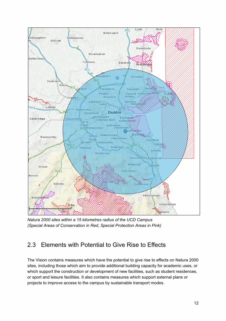
2.2 Identification of Relevant Natura 2000 Sites Guidance on appropriate assessment from the Department of Environment, Heritage and Local Government (2009) recommends that all Natura 2000 sites within a 15 kilometre radius of the plan area are considered, along with any sites greater than 15 kilometres from the plan, where there is potential pathway links. The National Parks and Wildlife Services (NPWS) Map Viewer was used to identify relevant sites. A total of 10 Special Areas of Conservation (SAC’s) and 7 Special Protection Areas
6
3/11/2019 Appendix 4: Natura Impact Assessment - Google Docs
https://docs.google.com/document/d/1_BUZ50nRf2J00c8LZZfEX1hOphRAmPslxSzagEGZT5c/edit#heading=h.nectouib8lfe 7/21
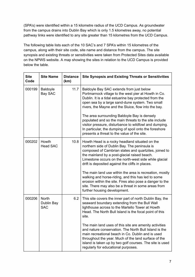
(SPA’s) were identified within a 15 kilometre radius of the UCD Campus. As groundwater from the campus drains into Dublin Bay which is only 1.5 kilometres away, no potential pathway links were identified to any site greater than 15 kilometres from the UCD Campus. The following table lists each of the 10 SAC’s and 7 SPA’s within 15 kilometres of the campus, along with their site code, site name and distance from the campus. The site synopsis and existing threats or sensitivities were taken from Protected Sites data available on the NPWS website. A map showing the sites in relation to the UCD Campus is provided below the table.
Site Code
Site Name Distance (km)
Site Synopsis and Existing Threats or Sensitivities
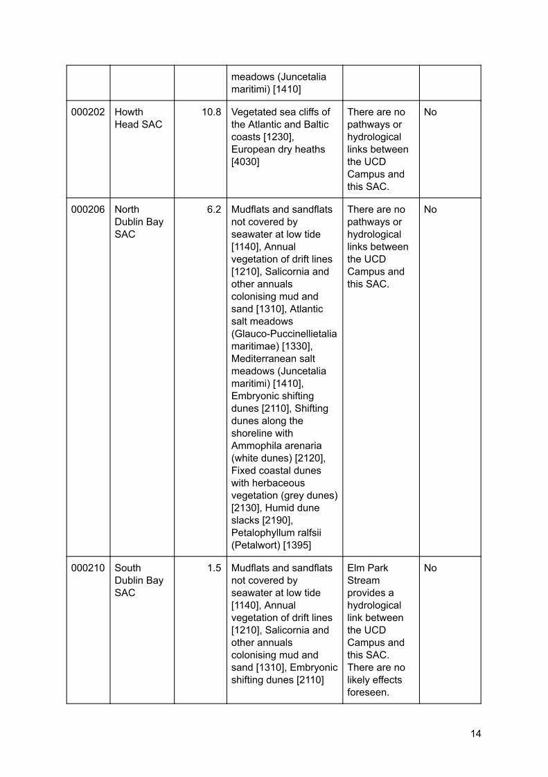
000199 Baldoyle Bay SAC
11.7 Baldoyle Bay SAC extends from just below Portmarnock village to the west pier at Howth in Co. Dublin. It is a tidal estuarine bay protected from the open sea by a large sand-dune system. Two small rivers, the Mayne and the Sluice, flow into the bay. The area surrounding Baldoyle Bay is densely populated and so the main threats to the site include visitor pressure, disturbance to wildfowl and dumping. In particular, the dumping of spoil onto the foreshore presents a threat to the value of the site.
000202 Howth Head SAC
10.8 Howth Head is a rocky headland situated on the northern side of Dublin Bay. The peninsula is composed of Cambrian slates and quartzites, joined to the mainland by a post-glacial raised beach. Limestone occurs on the north-west side while glacial drift is deposited against the cliffs in places. The main land use within the area is recreation, mostly walking and horse-riding, and this has led to some erosion within the site. Fires also pose a danger to the site. There may also be a threat in some areas from further housing development.
000206 North Dublin Bay SAC
6.2 This site covers the inner part of north Dublin Bay, the seaward boundary extending from the Bull Wall lighthouse across to the Martello Tower at Howth Head. The North Bull Island is the focal point of this site. The main land uses of this site are amenity activities and nature conservation. The North Bull Island is the main recreational beach in Co. Dublin and is used throughout the year. Much of the land surface of the island is taken up by two golf courses. The site is used regularly for educational purposes.
7
3/11/2019 Appendix 4: Natura Impact Assessment - Google Docs
https://docs.google.com/document/d/1_BUZ50nRf2J00c8LZZfEX1hOphRAmPslxSzagEGZT5c/edit#heading=h.nectouib8lfe 8/21
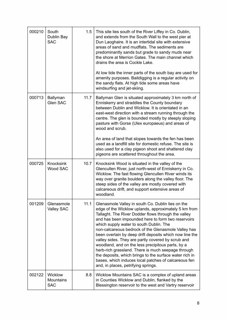
000210 South Dublin Bay SAC
1.5 This site lies south of the River Liffey in Co. Dublin, and extends from the South Wall to the west pier at Dun Laoghaire. It is an intertidal site with extensive areas of sand and mudflats. The sediments are predominantly sands but grade to sandy muds near the shore at Merrion Gates. The main channel which drains the area is Cockle Lake. At low tide the inner parts of the south bay are used for amenity purposes. Baitdigging is a regular activity on the sandy flats. At high tide some areas have windsurfing and jet-skiing.
000713 Ballyman Glen SAC
11.7 Ballyman Glen is situated approximately 3 km north of Enniskerry and straddles the County boundary between Dublin and Wicklow. It is orientated in an east-west direction with a stream running through the centre. The glen is bounded mostly by steeply sloping pasture with Gorse (Ulex europaeus) and areas of wood and scrub. An area of land that slopes towards the fen has been used as a landfill site for domestic refuse. The site is also used for a clay pigeon shoot and shattered clay pigeons are scattered throughout the area.
000725 Knocksink Wood SAC
10.7 Knocksink Wood is situated in the valley of the Glencullen River, just north-west of Enniskerry in Co. Wicklow. The fast flowing Glencullen River winds its way over granite boulders along the valley floor. The steep sides of the valley are mostly covered with calcareous drift, and support extensive areas of woodland.
001209 Glenasmole Valley SAC
11.1 Glenasmole Valley in south Co. Dublin lies on the edge of the Wicklow uplands, approximately 5 km from Tallaght. The River Dodder flows through the valley and has been impounded here to form two reservoirs which supply water to south Dublin. The non-calcareous bedrock of the Glenasmole Valley has been overlain by deep drift deposits which now line the valley sides. They are partly covered by scrub and woodland, and on the less precipitous parts, by a herb-rich grassland. There is much seepage through the deposits, which brings to the surface water rich in bases, which induces local patches of calcareous fen and, in places, petrifying springs.
002122 Wicklow Mountains SAC
8.8 Wicklow Mountains SAC is a complex of upland areas in Counties Wicklow and Dublin, flanked by the Blessington reservoir to the west and Vartry reservoir
8
3/11/2019 Appendix 4: Natura Impact Assessment - Google Docs
https://docs.google.com/document/d/1_BUZ50nRf2J00c8LZZfEX1hOphRAmPslxSzagEGZT5c/edit#heading=h.nectouib8lfe 9/21
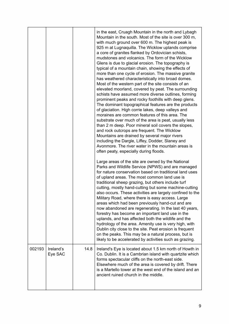
in the east, Cruagh Mountain in the north and Lybagh Mountain in the south. Most of the site is over 300 m, with much ground over 600 m. The highest peak is 925 m at Lugnaquilla. The Wicklow uplands comprise a core of granites flanked by Ordovician schists, mudstones and volcanics. The form of the Wicklow Glens is due to glacial erosion. The topography is typical of a mountain chain, showing the effects of more than one cycle of erosion. The massive granite has weathered characteristically into broad domes. Most of the western part of the site consists of an elevated moorland, covered by peat. The surrounding schists have assumed more diverse outlines, forming prominent peaks and rocky foothills with deep glens. The dominant topographical features are the products of glaciation. High corrie lakes, deep valleys and moraines are common features of this area. The substrate over much of the area is peat, usually less than 2 m deep. Poor mineral soil covers the slopes, and rock outcrops are frequent. The Wicklow Mountains are drained by several major rivers including the Dargle, Liffey, Dodder, Slaney and Avonmore. The river water in the mountain areas is often peaty, especially during floods. Large areas of the site are owned by the National Parks and Wildlife Service (NPWS) and are managed for nature conservation based on traditional land uses of upland areas. The most common land use is traditional sheep grazing, but others include turf cutting, mostly hand-cutting but some machine-cutting also occurs. These activities are largely confined to the Military Road, where there is easy access. Large areas which had been previously hand-cut and are now abandoned are regenerating. In the last 40 years, forestry has become an important land use in the uplands, and has affected both the wildlife and the hydrology of the area. Amenity use is very high, with Dublin city close to the site. Peat erosion is frequent on the peaks. This may be a natural process, but is likely to be accelerated by activities such as grazing.
002193 Ireland’s Eye SAC
14.8 Ireland's Eye is located about 1.5 km north of Howth in Co. Dublin. It is a Cambrian island with quartzite which forms spectacular cliffs on the north-east side. Elsewhere much of the area is covered by drift. There is a Martello tower at the west end of the island and an ancient ruined church in the middle.
9
3/11/2019 Appendix 4: Natura Impact Assessment - Google Docs
https://docs.google.com/document/d/1_BUZ50nRf2J00c8LZZfEX1hOphRAmPslxSzagEGZT5c/edit#heading=h.nectouib8lfe 10/21
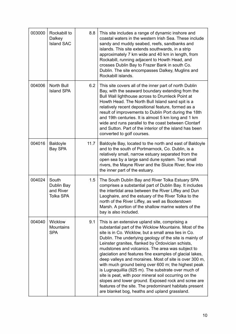
003000 Rockabill to Dalkey Island SAC
8.8 This site includes a range of dynamic inshore and coastal waters in the western Irish Sea. These include sandy and muddy seabed, reefs, sandbanks and islands. This site extends southwards, in a strip approximately 7 km wide and 40 km in length, from Rockabill, running adjacent to Howth Head, and crosses Dublin Bay to Frazer Bank in south Co. Dublin. The site encompasses Dalkey, Muglins and Rockabill islands.
004006 North Bull Island SPA
6.2 This site covers all of the inner part of north Dublin Bay, with the seaward boundary extending from the Bull Wall lighthouse across to Drumleck Point at Howth Head. The North Bull Island sand spit is a relatively recent depositional feature, formed as a result of improvements to Dublin Port during the 18th and 19th centuries. It is almost 5 km long and 1 km wide and runs parallel to the coast between Clontarf and Sutton. Part of the interior of the island has been converted to golf courses.
004016 Baldoyle Bay SPA
11.7 Baldoyle Bay, located to the north and east of Baldoyle and to the south of Portmarnock, Co. Dublin, is a relatively small, narrow estuary separated from the open sea by a large sand dune system. Two small rivers, the Mayne River and the Sluice River, flow into the inner part of the estuary.
004024 South Dublin Bay and River Tolka SPA
1.5 The South Dublin Bay and River Tolka Estuary SPA comprises a substantial part of Dublin Bay. It includes the intertidal area between the River Liffey and Dun Laoghaire, and the estuary of the River Tolka to the north of the River Liffey, as well as Booterstown Marsh. A portion of the shallow marine waters of the bay is also included.
004040 Wicklow Mountains SPA
9.1 This is an extensive upland site, comprising a substantial part of the Wicklow Mountains. Most of the site is in Co. Wicklow, but a small area lies in Co. Dublin. The underlying geology of the site is mainly of Leinster granites, flanked by Ordovician schists, mudstones and volcanics. The area was subject to glaciation and features fine examples of glacial lakes, deep valleys and moraines. Most of site is over 300 m, with much ground being over 600 m; the highest peak is Lugnaquillia (925 m). The substrate over much of site is peat, with poor mineral soil occurring on the slopes and lower ground. Exposed rock and scree are features of the site. The predominant habitats present are blanket bog, heaths and upland grassland.
10
3/11/2019 Appendix 4: Natura Impact Assessment - Google Docs
https://docs.google.com/document/d/1_BUZ50nRf2J00c8LZZfEX1hOphRAmPslxSzagEGZT5c/edit#heading=h.nectouib8lfe 11/21
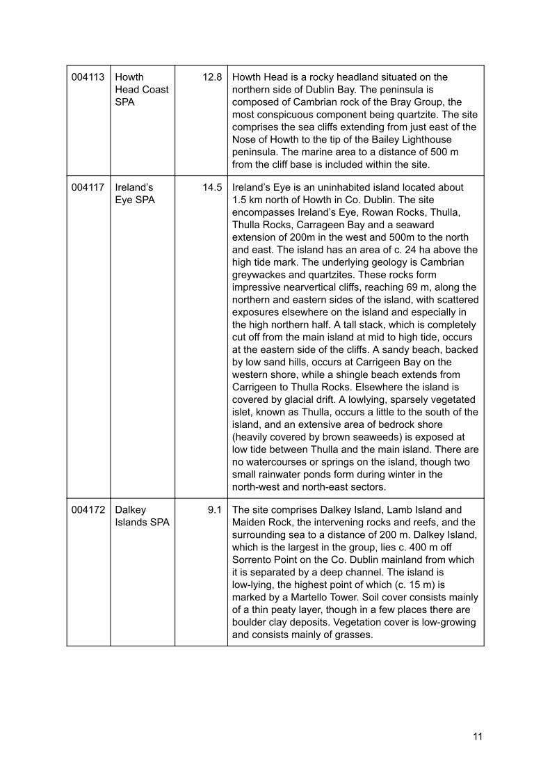
004113 Howth Head Coast SPA
12.8 Howth Head is a rocky headland situated on the northern side of Dublin Bay. The peninsula is composed of Cambrian rock of the Bray Group, the most conspicuous component being quartzite. The site comprises the sea cliffs extending from just east of the Nose of Howth to the tip of the Bailey Lighthouse peninsula. The marine area to a distance of 500 m from the cliff base is included within the site.
004117 Ireland’s Eye SPA
14.5 Ireland’s Eye is an uninhabited island located about 1.5 km north of Howth in Co. Dublin. The site encompasses Ireland’s Eye, Rowan Rocks, Thulla, Thulla Rocks, Carrageen Bay and a seaward extension of 200m in the west and 500m to the north and east. The island has an area of c. 24 ha above the high tide mark. The underlying geology is Cambrian greywackes and quartzites. These rocks form impressive nearvertical cliffs, reaching 69 m, along the northern and eastern sides of the island, with scattered exposures elsewhere on the island and especially in the high northern half. A tall stack, which is completely cut off from the main island at mid to high tide, occurs at the eastern side of the cliffs. A sandy beach, backed by low sand hills, occurs at Carrigeen Bay on the western shore, while a shingle beach extends from Carrigeen to Thulla Rocks. Elsewhere the island is covered by glacial drift. A lowlying, sparsely vegetated islet, known as Thulla, occurs a little to the south of the island, and an extensive area of bedrock shore (heavily covered by brown seaweeds) is exposed at low tide between Thulla and the main island. There are no watercourses or springs on the island, though two small rainwater ponds form during winter in the north-west and north-east sectors.
004172 Dalkey Islands SPA
9.1 The site comprises Dalkey Island, Lamb Island and Maiden Rock, the intervening rocks and reefs, and the surrounding sea to a distance of 200 m. Dalkey Island, which is the largest in the group, lies c. 400 m off Sorrento Point on the Co. Dublin mainland from which it is separated by a deep channel. The island is low-lying, the highest point of which (c. 15 m) is marked by a Martello Tower. Soil cover consists mainly of a thin peaty layer, though in a few places there are boulder clay deposits. Vegetation cover is low-growing and consists mainly of grasses.
11
3/11/2019 Appendix 4: Natura Impact Assessment - Google Docs
https://docs.google.com/document/d/1_BUZ50nRf2J00c8LZZfEX1hOphRAmPslxSzagEGZT5c/edit#heading=h.nectouib8lfe 12/21
Natura 2000 sites within a 15 kilometres radius of the UCD Campus (Special Areas of Conservation in Red, Special Protection Areas in Pink)
2.3 Elements with Potential to Give Rise to Effects The Vision contains measures which have the potential to give rise to effects on Natura 2000 sites, including those which aim to provide additional building capacity for academic uses, or which support the construction or development of new facilities, such as student residences, or sport and leisure facilities. It also contains measures which support external plans or projects to improve access to the campus by sustainable transport modes.
12
3/11/2019 Appendix 4: Natura Impact Assessment - Google Docs
https://docs.google.com/document/d/1_BUZ50nRf2J00c8LZZfEX1hOphRAmPslxSzagEGZT5c/edit#heading=h.nectouib8lfe 13/21
Any projects arising from this Vision, which have the potential to give rise to effects on Natura 2000 sites, will be subject to appropriate assessment during the statutory planning application process. In addition, elements of the Vision, such as the measures set out in Section 4 pertaining to Environment and Sustainability, will have, it is thought, a positive ecological effect on the area.
2.4 Identification of Potential Likely Significant Effects This section documents the final stage of the screening process. It has used the information collected on the sensitivity of each Natura 2000 Site and describes any likely significant effects resulting from the Vision. This assumes the absence of any controls, conditions, or mitigation measures. In determining the potential for significant effects, a number of factors have been taken into account. Firstly, the sensitivity and reported threats to the European Site. Secondly, the individual elements of the Vision and the potential effect they may cause to the site were considered. Sites are screened out based on one or a combination of the following criteria:
● where it can be shown that there are no pathways or links between activities of the Vision, and the site to be screened;
● where the site is located at such a distance from the UCD Campus that effects are not anticipated;
● where known threats or vulnerabilities at a site cannot be linked to potential impacts that may arise from the Vision; and
● where there are no significant in-combination effects. The elements of the Vision with potential to cause effect to Natura 2000 Sites are presented in the table below.
Site Code
Site Name Distance (km)
Qualifying Interests (Sensitive Receptors)
Pathways Potential for Significant Effects
000199 Baldoyle Bay SAC
11.7 Mudflats and sandflats not covered by seawater at low tide [1140], Salicornia and other annuals colonising mud and sand [1310], Atlantic salt meadows (Glauco-Puccinellietalia maritimae) [1330], Mediterranean salt
There are no pathways or hydrological links between the UCD Campus and this SAC.
No
13
3/11/2019 Appendix 4: Natura Impact Assessment - Google Docs
https://docs.google.com/document/d/1_BUZ50nRf2J00c8LZZfEX1hOphRAmPslxSzagEGZT5c/edit#heading=h.nectouib8lfe 14/21
meadows (Juncetalia maritimi) [1410]
000202 Howth Head SAC
10.8 Vegetated sea cliffs of the Atlantic and Baltic coasts [1230], European dry heaths [4030]
There are no pathways or hydrological links between the UCD Campus and this SAC.
No
000206 North Dublin Bay SAC
6.2 Mudflats and sandflats not covered by seawater at low tide [1140], Annual vegetation of drift lines [1210], Salicornia and other annuals colonising mud and sand [1310], Atlantic salt meadows (Glauco-Puccinellietalia maritimae) [1330], Mediterranean salt meadows (Juncetalia maritimi) [1410], Embryonic shifting dunes [2110], Shifting dunes along the shoreline with Ammophila arenaria (white dunes) [2120], Fixed coastal dunes with herbaceous vegetation (grey dunes) [2130], Humid dune slacks [2190], Petalophyllum ralfsii (Petalwort) [1395]
There are no pathways or hydrological links between the UCD Campus and this SAC.
No
000210 South Dublin Bay SAC
1.5 Mudflats and sandflats not covered by seawater at low tide [1140], Annual vegetation of drift lines [1210], Salicornia and other annuals colonising mud and sand [1310], Embryonic shifting dunes [2110]
Elm Park Stream provides a hydrological link between the UCD Campus and this SAC. There are no likely effects foreseen.
No
14
3/11/2019 Appendix 4: Natura Impact Assessment - Google Docs
https://docs.google.com/document/d/1_BUZ50nRf2J00c8LZZfEX1hOphRAmPslxSzagEGZT5c/edit#heading=h.nectouib8lfe 15/21
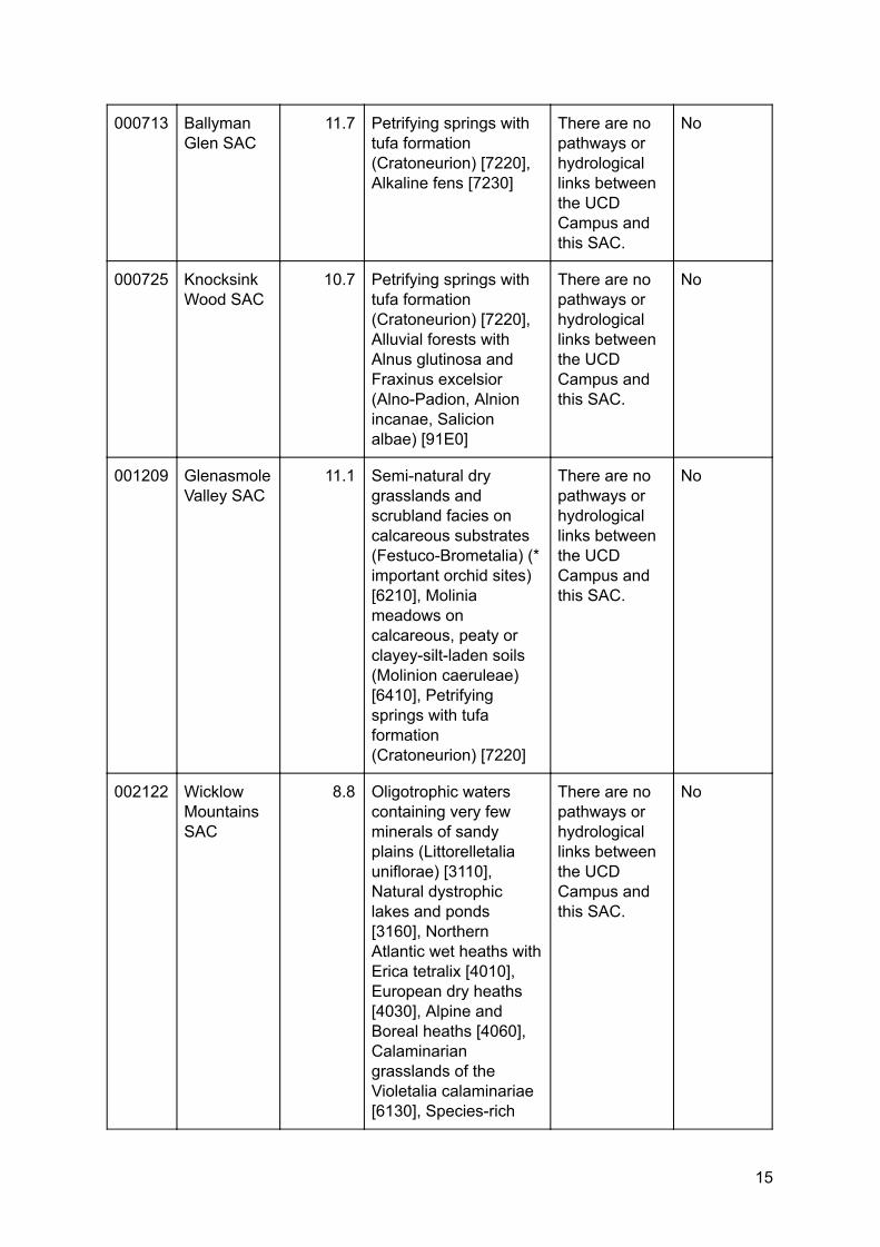
000713 Ballyman Glen SAC
11.7 Petrifying springs with tufa formation (Cratoneurion) [7220], Alkaline fens [7230]
There are no pathways or hydrological links between the UCD Campus and this SAC.
No
000725 Knocksink Wood SAC
10.7 Petrifying springs with tufa formation (Cratoneurion) [7220], Alluvial forests with Alnus glutinosa and Fraxinus excelsior (Alno-Padion, Alnion incanae, Salicion albae) [91E0]
There are no pathways or hydrological links between the UCD Campus and this SAC.
No
001209 Glenasmole Valley SAC
11.1 Semi-natural dry grasslands and scrubland facies on calcareous substrates (Festuco-Brometalia) (* important orchid sites) [6210], Molinia meadows on calcareous, peaty or clayey-silt-laden soils (Molinion caeruleae) [6410], Petrifying springs with tufa formation (Cratoneurion) [7220]
There are no pathways or hydrological links between the UCD Campus and this SAC.
No
002122 Wicklow Mountains SAC
8.8 Oligotrophic waters containing very few minerals of sandy plains (Littorelletalia uniflorae) [3110], Natural dystrophic lakes and ponds [3160], Northern Atlantic wet heaths with Erica tetralix [4010], European dry heaths [4030], Alpine and Boreal heaths [4060], Calaminarian grasslands of the Violetalia calaminariae [6130], Species-rich
There are no pathways or hydrological links between the UCD Campus and this SAC.
No
15
3/11/2019 Appendix 4: Natura Impact Assessment - Google Docs
https://docs.google.com/document/d/1_BUZ50nRf2J00c8LZZfEX1hOphRAmPslxSzagEGZT5c/edit#heading=h.nectouib8lfe 16/21
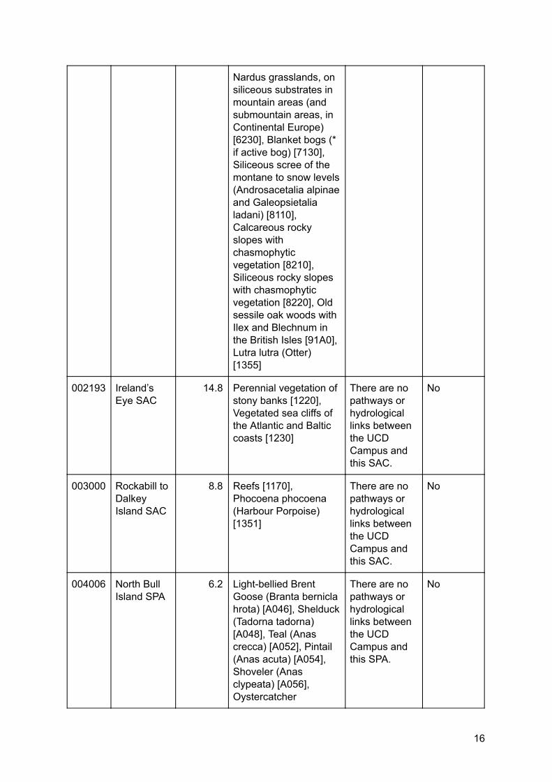
Nardus grasslands, on siliceous substrates in mountain areas (and submountain areas, in Continental Europe) [6230], Blanket bogs (* if active bog) [7130], Siliceous scree of the montane to snow levels (Androsacetalia alpinae and Galeopsietalia ladani) [8110], Calcareous rocky slopes with chasmophytic vegetation [8210], Siliceous rocky slopes with chasmophytic vegetation [8220], Old sessile oak woods with Ilex and Blechnum in the British Isles [91A0], Lutra lutra (Otter) [1355]
002193 Ireland’s Eye SAC
14.8 Perennial vegetation of stony banks [1220], Vegetated sea cliffs of the Atlantic and Baltic coasts [1230]
There are no pathways or hydrological links between the UCD Campus and this SAC.
No
003000 Rockabill to Dalkey Island SAC
8.8 Reefs [1170], Phocoena phocoena (Harbour Porpoise) [1351]
There are no pathways or hydrological links between the UCD Campus and this SAC.
No
004006 North Bull Island SPA
6.2 Light-bellied Brent Goose (Branta bernicla hrota) [A046], Shelduck (Tadorna tadorna) [A048], Teal (Anas crecca) [A052], Pintail (Anas acuta) [A054], Shoveler (Anas clypeata) [A056], Oystercatcher
There are no pathways or hydrological links between the UCD Campus and this SPA.
No
16
3/11/2019 Appendix 4: Natura Impact Assessment - Google Docs
https://docs.google.com/document/d/1_BUZ50nRf2J00c8LZZfEX1hOphRAmPslxSzagEGZT5c/edit#heading=h.nectouib8lfe 17/21
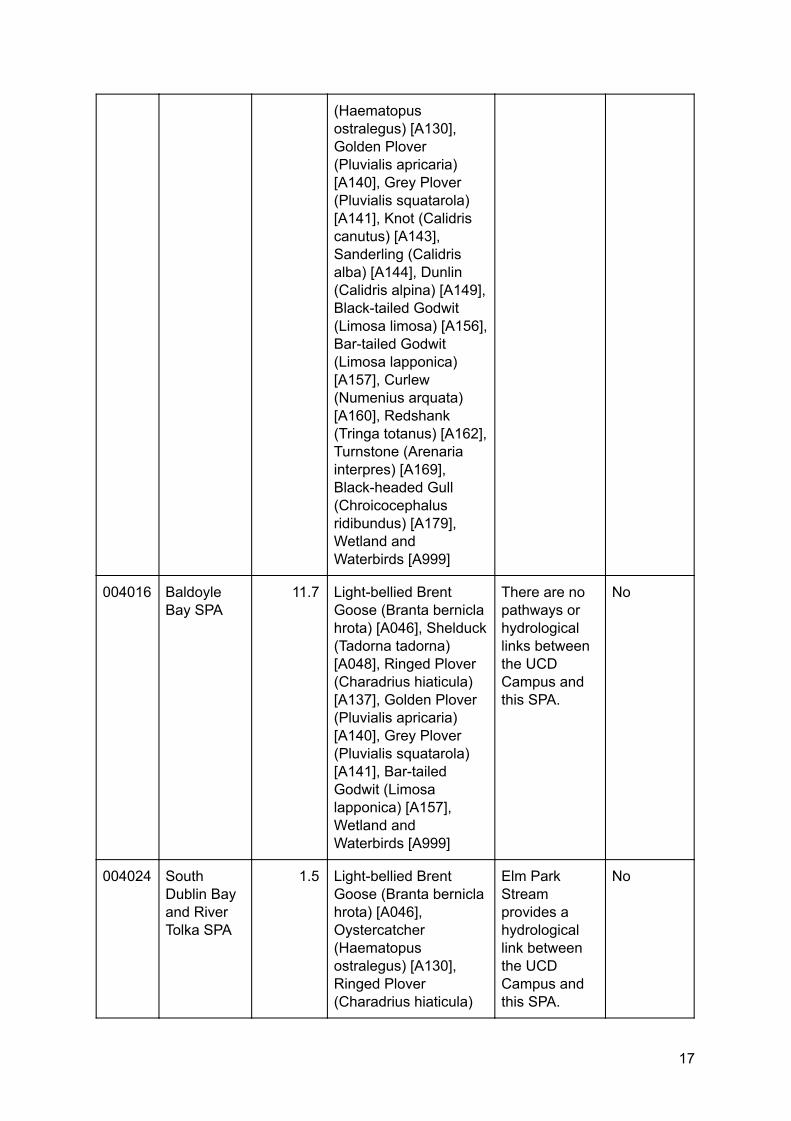
(Haematopus ostralegus) [A130], Golden Plover (Pluvialis apricaria) [A140], Grey Plover (Pluvialis squatarola) [A141], Knot (Calidris canutus) [A143], Sanderling (Calidris alba) [A144], Dunlin (Calidris alpina) [A149], Black-tailed Godwit (Limosa limosa) [A156], Bar-tailed Godwit (Limosa lapponica) [A157], Curlew (Numenius arquata) [A160], Redshank (Tringa totanus) [A162], Turnstone (Arenaria interpres) [A169], Black-headed Gull (Chroicocephalus ridibundus) [A179], Wetland and Waterbirds [A999]
004016 Baldoyle Bay SPA
11.7 Light-bellied Brent Goose (Branta bernicla hrota) [A046], Shelduck (Tadorna tadorna) [A048], Ringed Plover (Charadrius hiaticula) [A137], Golden Plover (Pluvialis apricaria) [A140], Grey Plover (Pluvialis squatarola) [A141], Bar-tailed Godwit (Limosa lapponica) [A157], Wetland and Waterbirds [A999]
There are no pathways or hydrological links between the UCD Campus and this SPA.
No
004024 South Dublin Bay and River Tolka SPA
1.5 Light-bellied Brent Goose (Branta bernicla hrota) [A046], Oystercatcher (Haematopus ostralegus) [A130], Ringed Plover (Charadrius hiaticula)
Elm Park Stream provides a hydrological link between the UCD Campus and this SPA.
No
17
3/11/2019 Appendix 4: Natura Impact Assessment - Google Docs
https://docs.google.com/document/d/1_BUZ50nRf2J00c8LZZfEX1hOphRAmPslxSzagEGZT5c/edit#heading=h.nectouib8lfe 18/21
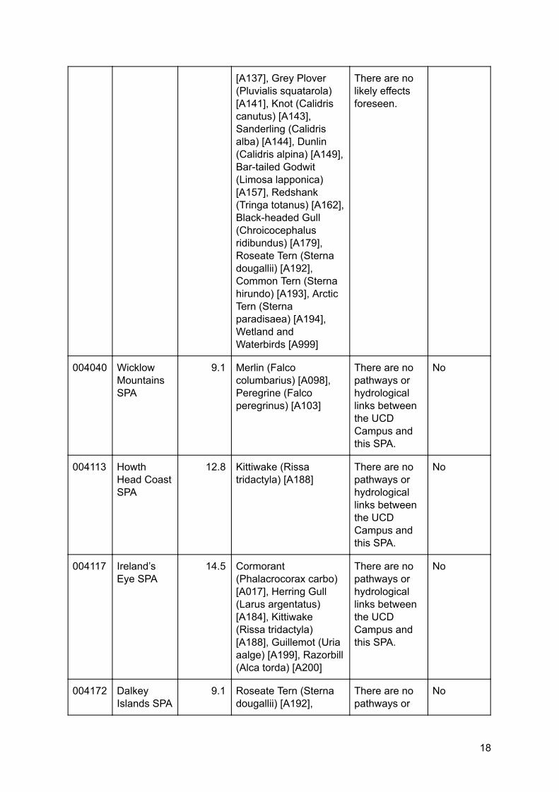
[A137], Grey Plover (Pluvialis squatarola) [A141], Knot (Calidris canutus) [A143], Sanderling (Calidris alba) [A144], Dunlin (Calidris alpina) [A149], Bar-tailed Godwit (Limosa lapponica) [A157], Redshank (Tringa totanus) [A162], Black-headed Gull (Chroicocephalus ridibundus) [A179], Roseate Tern (Sterna dougallii) [A192], Common Tern (Sterna hirundo) [A193], Arctic Tern (Sterna paradisaea) [A194], Wetland and Waterbirds [A999]
There are no likely effects foreseen.
004040 Wicklow Mountains SPA
9.1 Merlin (Falco columbarius) [A098], Peregrine (Falco peregrinus) [A103]
There are no pathways or hydrological links between the UCD Campus and this SPA.
No
004113 Howth Head Coast SPA
12.8 Kittiwake (Rissa tridactyla) [A188]
There are no pathways or hydrological links between the UCD Campus and this SPA.
No
004117 Ireland’s Eye SPA
14.5 Cormorant (Phalacrocorax carbo) [A017], Herring Gull (Larus argentatus) [A184], Kittiwake (Rissa tridactyla) [A188], Guillemot (Uria aalge) [A199], Razorbill (Alca torda) [A200]
There are no pathways or hydrological links between the UCD Campus and this SPA.
No
004172 Dalkey Islands SPA
9.1 Roseate Tern (Sterna dougallii) [A192],
There are no pathways or
No
18
3/11/2019 Appendix 4: Natura Impact Assessment - Google Docs
https://docs.google.com/document/d/1_BUZ50nRf2J00c8LZZfEX1hOphRAmPslxSzagEGZT5c/edit#heading=h.nectouib8lfe 19/21
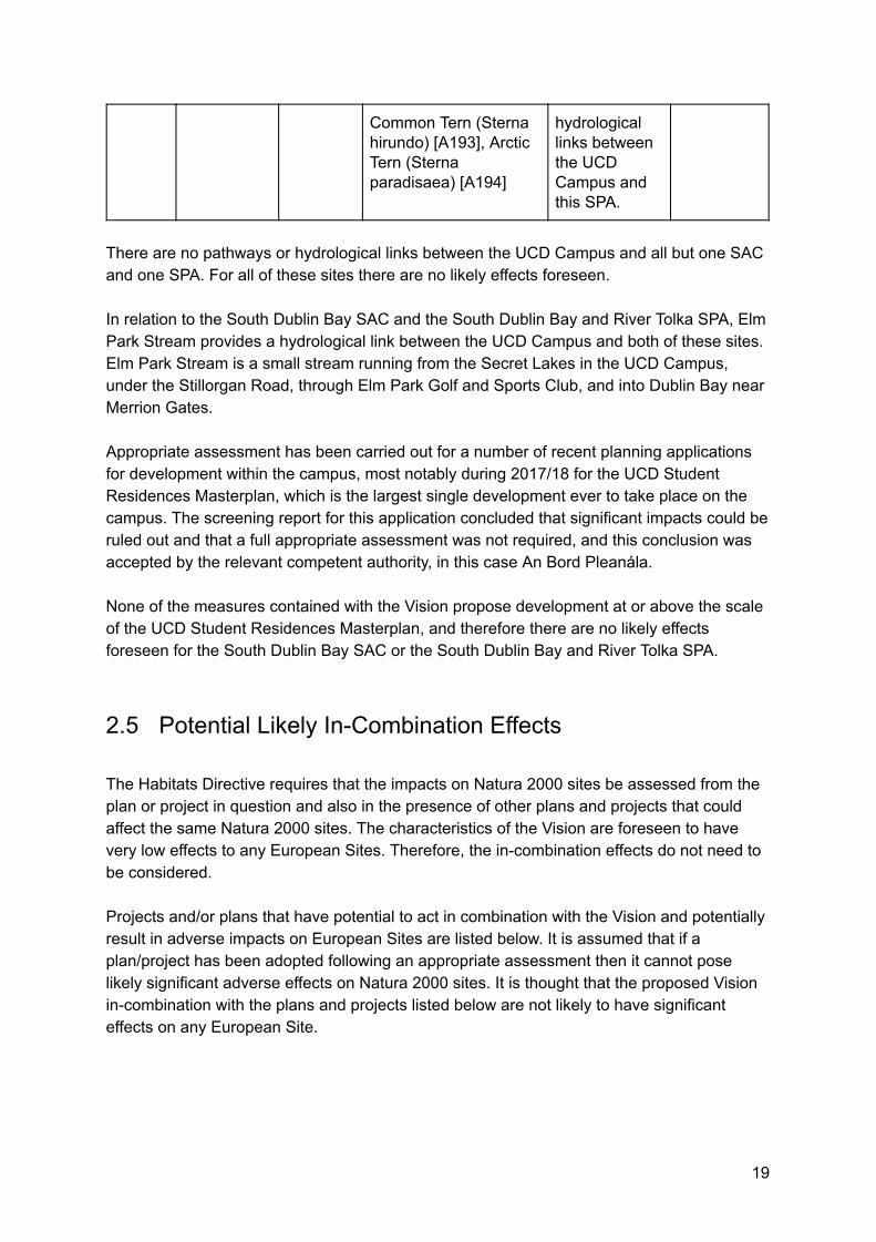
Common Tern (Sterna hirundo) [A193], Arctic Tern (Sterna paradisaea) [A194]
hydrological links between the UCD Campus and this SPA.
There are no pathways or hydrological links between the UCD Campus and all but one SAC and one SPA. For all of these sites there are no likely effects foreseen. In relation to the South Dublin Bay SAC and the South Dublin Bay and River Tolka SPA, Elm Park Stream provides a hydrological link between the UCD Campus and both of these sites. Elm Park Stream is a small stream running from the Secret Lakes in the UCD Campus, under the Stillorgan Road, through Elm Park Golf and Sports Club, and into Dublin Bay near Merrion Gates. Appropriate assessment has been carried out for a number of recent planning applications for development within the campus, most notably during 2017/18 for the UCD Student Residences Masterplan, which is the largest single development ever to take place on the campus. The screening report for this application concluded that significant impacts could be ruled out and that a full appropriate assessment was not required, and this conclusion was accepted by the relevant competent authority, in this case An Bord Pleanála. None of the measures contained with the Vision propose development at or above the scale of the UCD Student Residences Masterplan, and therefore there are no likely effects foreseen for the South Dublin Bay SAC or the South Dublin Bay and River Tolka SPA.
2.5 Potential Likely In-Combination Effects The Habitats Directive requires that the impacts on Natura 2000 sites be assessed from the plan or project in question and also in the presence of other plans and projects that could affect the same Natura 2000 sites. The characteristics of the Vision are foreseen to have very low effects to any European Sites. Therefore, the in-combination effects do not need to be considered. Projects and/or plans that have potential to act in combination with the Vision and potentially result in adverse impacts on European Sites are listed below. It is assumed that if a plan/project has been adopted following an appropriate assessment then it cannot pose likely significant adverse effects on Natura 2000 sites. It is thought that the proposed Vision in-combination with the plans and projects listed below are not likely to have significant effects on any European Site.
19
3/11/2019 Appendix 4: Natura Impact Assessment - Google Docs
https://docs.google.com/document/d/1_BUZ50nRf2J00c8LZZfEX1hOphRAmPslxSzagEGZT5c/edit#heading=h.nectouib8lfe 20/21
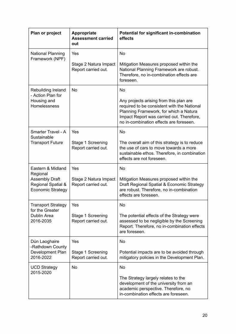
Plan or project Appropriate Assessment carried out
Potential for significant in-combination effects
National Planning Framework (NPF)
Yes Stage 2 Natura Impact Report carried out.
No Mitigation Measures proposed within the National Planning Framework are robust. Therefore, no in-combination effects are foreseen.
Rebuilding Ireland - Action Plan for Housing and Homelessness
No No Any projects arising from this plan are required to be consistent with the National Planning Framework, for which a Natura Impact Report was carried out. Therefore, no in-combination effects are foreseen.
Smarter Travel - A Sustainable Transport Future
Yes Stage 1 Screening Report carried out.
No The overall aim of this strategy is to reduce the use of cars to move towards a more sustainable ethos. Therefore, in combination effects are not foreseen.
Eastern & Midland Regional Assembly Draft Regional Spatial & Economic Strategy
Yes Stage 2 Natura Impact Report carried out.
No Mitigation Measures proposed within the Draft Regional Spatial & Economic Strategy are robust. Therefore, no in-combination effects are foreseen.
Transport Strategy for the Greater Dublin Area 2016-2035
Yes Stage 1 Screening Report carried out.
No The potential effects of the Strategy were assessed to be negligible by the Screening Report. Therefore, no in-combination effects are foreseen.
Dún Laoghaire -Rathdown County Development Plan 2016-2022
Yes Stage 1 Screening Report carried out.
No Potential impacts are to be avoided through mitigatory policies in the Development Plan.
UCD Strategy 2015-2020
No No The Strategy largely relates to the development of the university from an academic perspective. Therefore, no in-combination effects are foreseen.
20
3/11/2019 Appendix 4: Natura Impact Assessment - Google Docs
https://docs.google.com/document/d/1_BUZ50nRf2J00c8LZZfEX1hOphRAmPslxSzagEGZT5c/edit#heading=h.nectouib8lfe 21/21
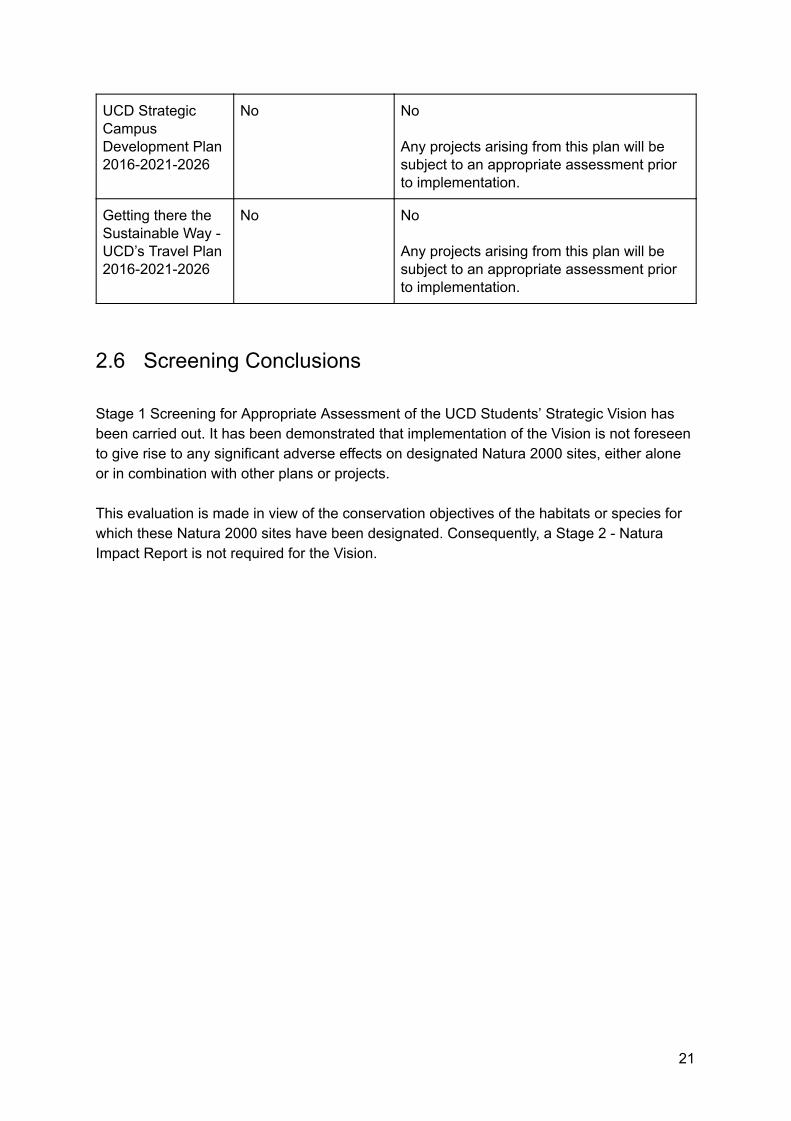
UCD Strategic Campus Development Plan 2016-2021-2026
No No Any projects arising from this plan will be subject to an appropriate assessment prior to implementation.
Getting there the Sustainable Way - UCD’s Travel Plan 2016-2021-2026
No No Any projects arising from this plan will be subject to an appropriate assessment prior to implementation.
2.6 Screening Conclusions Stage 1 Screening for Appropriate Assessment of the UCD Students’ Strategic Vision has been carried out. It has been demonstrated that implementation of the Vision is not foreseen to give rise to any significant adverse effects on designated Natura 2000 sites, either alone or in combination with other plans or projects. This evaluation is made in view of the conservation objectives of the habitats or species for which these Natura 2000 sites have been designated. Consequently, a Stage 2 - Natura Impact Report is not required for the Vision.
21