Embed Size (px)
Citation preview
Transport Scotland Strategic Transport Projects Review Report 1 – Review of Current and Future Network Performance
572
7.16 Corridor 16: Stranraer to North West England and beyond
7.16.1 Setting the Context
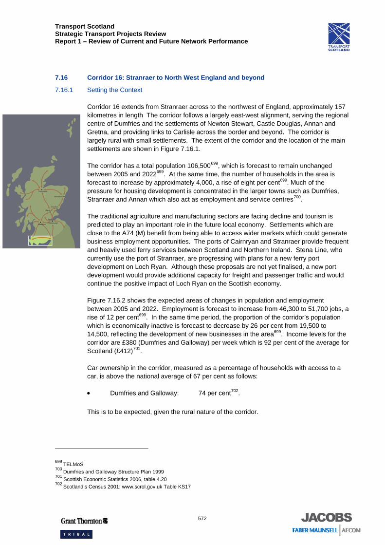
Corridor 16 extends from Stranraer across to the northwest of England, approximately 157 kilometres in length The corridor follows a largely east-west alignment, serving the regional centre of Dumfries and the settlements of Newton Stewart, Castle Douglas, Annan and Gretna, and providing links to Carlisle across the border and beyond. The corridor is largely rural with small settlements. The extent of the corridor and the location of the main settlements are shown in Figure 7.16.1.
The corridor has a total population 106,500699, which is forecast to remain unchanged between 2005 and 2022699. At the same time, the number of households in the area is forecast to increase by approximately 4,000, a rise of eight per cent699. Much of the pressure for housing development is concentrated in the larger towns such as Dumfries, Stranraer and Annan which also act as employment and service centres700.
The traditional agriculture and manufacturing sectors are facing decline and tourism is predicted to play an important role in the future local economy. Settlements which are close to the A74 (M) benefit from being able to access wider markets which could generate business employment opportunities. The ports of Cairnryan and Stranraer provide frequent and heavily used ferry services between Scotland and Northern Ireland. Stena Line, who currently use the port of Stranraer, are progressing with plans for a new ferry port development on Loch Ryan. Although these proposals are not yet finalised, a new port development would provide additional capacity for freight and passenger traffic and would continue the positive impact of Loch Ryan on the Scottish economy.
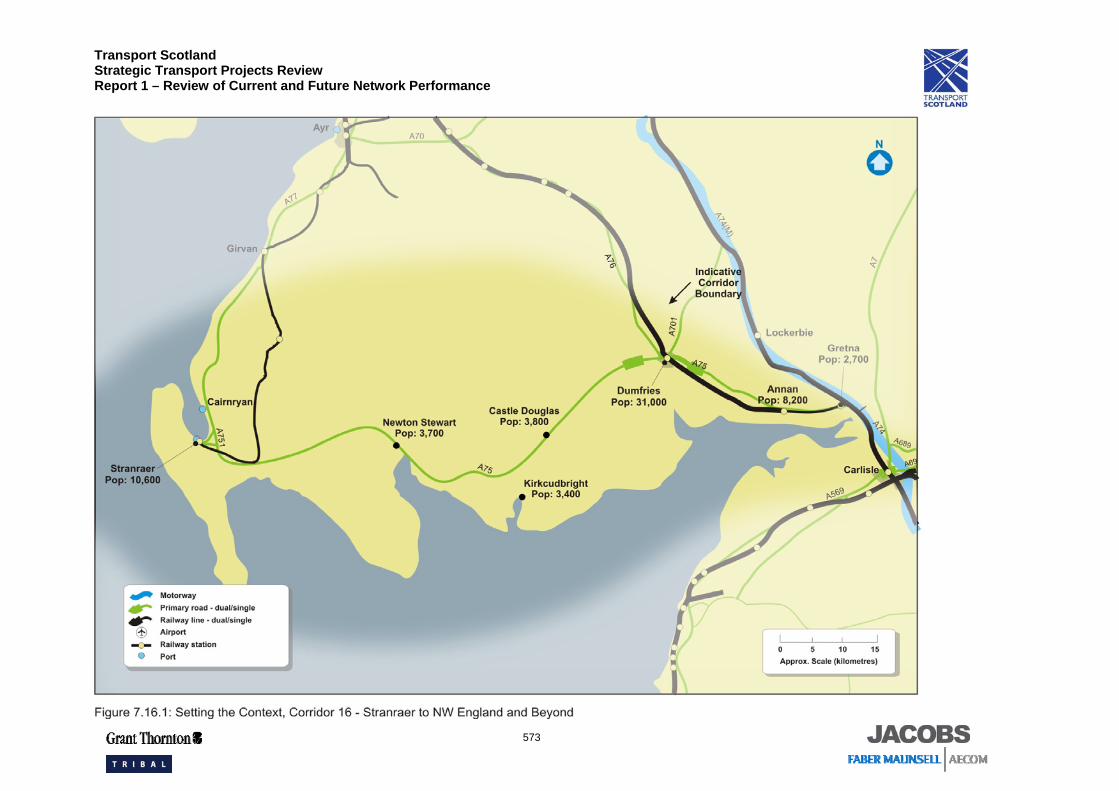
Figure 7.16.2 shows the expected areas of changes in population and employment between 2005 and 2022. Employment is forecast to increase from 46,300 to 51,700 jobs, a rise of 12 per cent699. In the same time period, the proportion of the corridor’s population which is economically inactive is forecast to decrease by 26 per cent from 19,500 to 14,500, reflecting the development of new businesses in the area699. Income levels for the corridor are £380 (Dumfries and Galloway) per week which is 92 per cent of the average for Scotland (£412)701.
Car ownership in the corridor, measured as a percentage of households with access to a car, is above the national average of 67 per cent as follows:
• Dumfries and Galloway: 74 per cent702. This is to be expected, given the rural nature of the corridor.
699 TELMoS 700 Dumfries and Galloway Structure Plan 1999 701 Scottish Economic Statistics 2006, table 4.20 702 Scotland’s Census 2001: www.scrol.gov.uk Table KS17
Transport Scotland Strategic Transport Projects Review Report 1 – Review of Current and Future Network Performance
573
Transport Scotland Strategic Transport Projects Review Report 1 – Review of Current and Future Network Performance
574
Transport Scotland Strategic Transport Projects Review Report 1 – Review of Current and Future Network Performance
575
7.16.2 Transport Network and Operations
Infrastructure and Services
The principal elements of the transport network that play a national strategic role are shown in Figure 7.16.1.
The A75 road from Stranraer to Gretna is the main element of the road network within the south west of Scotland and is the only Scottish Trunk Road to appear in the list of priority Trans European Network projects. It is predominately single carriageway with three short dual carriageway sections at Gretna, Collin (east of Dumfries) and west of Dumfries. The A75 passes through the key settlements on the route and fulfils a dual purpose role of strategic link and local connector. It is a part of the Trans European Network, reflecting its strategic role in connecting with the ports of Loch Ryan.
Other important local roads include the A751 Stranraer Bypass which links the A75 to the A77.
The ports of Cairnryan and Stranraer provide frequent and heavily used ferry services between Scotland and Northern Ireland.
There are no direct rail services which connect the two ends of the corridor. Stranraer is the terminus of the coastal route from Glasgow via Ayr (Corridor 15), whereas Dumfries and Annan are on the route from Glasgow to Carlisle via Kilmarnock. There are approximately 13 rail services per day on the Glasgow – Kilmarnock – Carlisle route serving Dumfries, offering a total capacity of approximately 150 seats per hour in each direction. This is covered in Corridor 18 (Glasgow to North West England). Rail journeys between Carlisle and Stranraer therefore have to travel via Kilmarnock, a lengthy detour. Dumfries is the principal station in the corridor by passenger throughput. Just beyond the corridor, Lockerbie has a railway station on the West Coast Main Line. However, there is no direct rail link or trunk road link to it from Dumfries.
Bus services operate along the length of the corridor. Services are operated by Stagecoach703. Service patterns are generally:
• one service per hour between Carlisle and Dumfries via Annan using the A7, A74, M74, B721, A75 and A780 (Service 79);
• one service per hour between Carlisle and Dumfries via Longtown and Annan using the A7, A6071, B721, A75 and A780 (Service 179); and
• one service every 90 minutes between Dumfries and Stranraer via Castle Douglas and Newton Stewart using the A75 (Service 500 / X75).
Bus capacity on the length of the corridor is approximately 50 seats per hour in each direction. There are several additional services, mainly concentrated on the eastern end of the corridor in the vicinity of Dumfries.
703 Stagecoach West Scotland: http://www.stagecoachbus.com/western/aboutus.html
Transport Scotland Strategic Transport Projects Review Report 1 – Review of Current and Future Network Performance
576
In Dumfries, the rail station is well served by strategic bus services. However, Annan and Gretna rail stations are less well served. Stranraer provides good integration between bus, rail and ferry services to Larne and Belfast but the port of Cairnryan is not served by the rail network.
An integrated ticket is available for rail journeys into Dumfries in the form of the PLUSBUS ticket. This ticket covers rail journeys and unlimited bus travel within Dumfries.
Asset Management
In 2007, five per cent of the trunk road network pavement704 in this corridor is judged to require structural strengthening as it has no theoretical residual strength. This compares with a national level of four per cent705. Under Transport Scotland’s planned maintenance schedule, the net figure for the corridor is expected to fall to four per cent by 2012.
Further details on asset management, including bus and rail, are provided in Chapter 4.
Demand Management
There are no bus priority measures in this corridor. Parking is provided at the railway stations in Dumfries, Gretna and Annan.
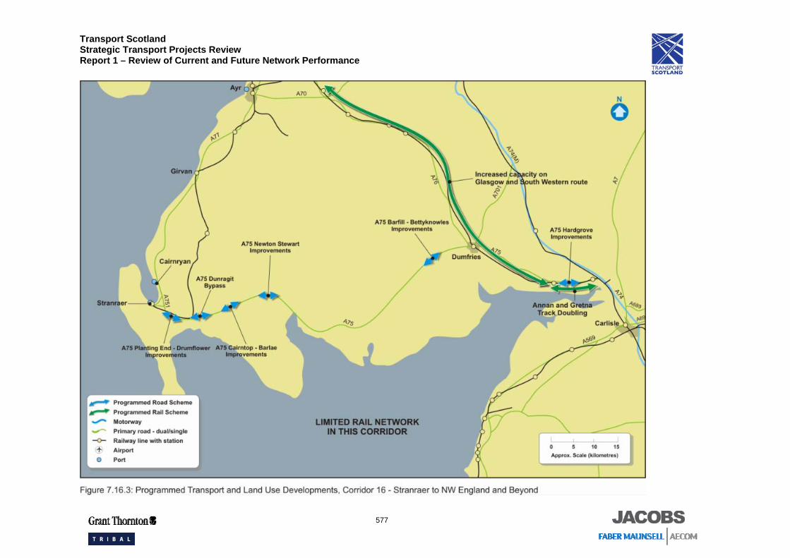
Programmed Schemes
The following are programmed schemes in the corridor (highlighted in Figure 7.16.3):
• A75 Cairntop to Barlae dual carriageway for increased overtaking opportunities;
• A75 Hardgrove to Kinmount, off line scheme for increased overtaking opportunities;
• A75 Barfil to Bettyknowes widening for increased overtaking opportunities;
• A75 Planting End widening for increased overtaking opportunities;
• A75 Newton Stewart widening for increased overtaking opportunities;
• A75 Dunragit Bypass with provision for increased overtaking opportunities;
• Intermediate Block Signals to increase capacity on Glasgow and South Western Railway route; and
• Annan to Gretna rail line doubling.
704 Transport Scotland SERIS Database 705 STS No. 25 (2006) Table 5.5
Transport Scotland Strategic Transport Projects Review Report 1 – Review of Current and Future Network Performance
577
Transport Scotland Strategic Transport Projects Review Report 1 – Review of Current and Future Network Performance
578
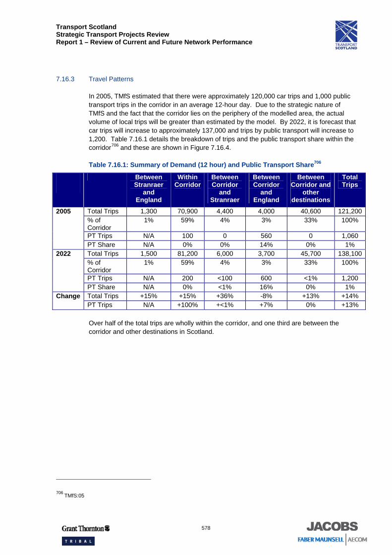
7.16.3 Travel Patterns
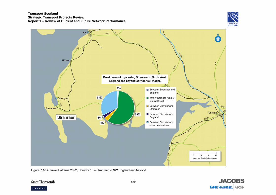
In 2005, TMfS estimated that there were approximately 120,000 car trips and 1,000 public transport trips in the corridor in an average 12-hour day. Due to the strategic nature of TMfS and the fact that the corridor lies on the periphery of the modelled area, the actual volume of local trips will be greater than estimated by the model. By 2022, it is forecast that car trips will increase to approximately 137,000 and trips by public transport will increase to 1,200. Table 7.16.1 details the breakdown of trips and the public transport share within the corridor706 and these are shown in Figure 7.16.4.
Table 7.16.1: Summary of Demand (12 hour) and Public Transport Share706
Between Stranraer
and England
Within Corridor
Between Corridor
and Stranraer
Between Corridor
and England
Between Corridor and
other destinations
Total Trips
Total Trips 1,300 70,900 4,400 4,000 40,600 121,200% of Corridor
1% 59% 4% 3% 33% 100%
PT Trips N/A 100 0 560 0 1,060
2005
PT Share N/A 0% 0% 14% 0% 1% Total Trips 1,500 81,200 6,000 3,700 45,700 138,100% of Corridor
1% 59% 4% 3% 33% 100%
PT Trips N/A 200 <100 600 <1% 1,200
2022
PT Share N/A 0% <1% 16% 0% 1% Total Trips +15% +15% +36% -8% +13% +14% Change PT Trips N/A +100% +<1% +7% 0% +13% Over half of the total trips are wholly within the corridor, and one third are between the corridor and other destinations in Scotland.
706 TMfS:05
Transport Scotland Strategic Transport Projects Review Report 1 – Review of Current and Future Network Performance
579
Transport Scotland Strategic Transport Projects Review Report 1 – Review of Current and Future Network Performance
580
The 2022 figures indicate that the overall distribution of travel is expected to remain largely unchanged over time. Public transport use is expected to remain low.
The AADT levels in the year 2006 on the A75 varied along the corridor from approximately 3,900 vehicles at the Stranraer end of the corridor to around 12,200 vehicles in the Dumfries area. This reflects the higher population and employment at the eastern end of the corridor and trips towards Corridor 18 (Glasgow to North West England). ATC data from the SRTDb gives a figure of approximately 26 per cent HGV traffic on the A75 at Carsluith707. This route experiences a high percentage of HGV traffic and as such is important for freight, which consists largely of traffic using the Loch Ryan ports as well as timber freight.
Rail services from Stranraer railway station provide links to Ayrshire and Glasgow, transporting passengers from the ferry terminal. The corridor is a key route for freight, especially timber, which is transported by road to the north of England and provides access to the A74 (M). Stranraer and Cairnryan ports play a major role in providing tourist and commercial travel to Northern Ireland.
The main railway stations at the end points of this corridor - Dumfries, Gretna and Annan - have a total throughput of some 477,000 passengers per annum (2005). Whilst Dumfries, Annan and Gretna railway stations are all directly connected Stranraer is not directly connected by rail to the rest of the corridor. Stranraer has a total throughput of some 53,200 passengers per annum (2005)708. There is no rail freight on the Stranraer branch, but the Glasgow and South Western line is a significant freight route.
Around 1.2 million passengers and 1.2 million tonnes of freight pass through Stranraer port per annum. Cairnryan handles a further 600,000 passengers and 3.2 million tonnes of freight709.
Details of ferry loading from Stranraer are reported in Corridor 15 (Glasgow to Ayrshire and Stranraer).
7.16.4 Performance Review
Journey Times and Connections
This section addresses the following questions from Table 3.1:
• Does the network offer competitive journey times? • Is the network operating efficiently and reliably? • Where are the delays and when do they occur?
707 SRTDb 708 Rail industry LENNON data (Station Usage 2004/2005) 709 STS No. 25 (2006) Table 10.3, 10.12
Transport Scotland Strategic Transport Projects Review Report 1 – Review of Current and Future Network Performance
581
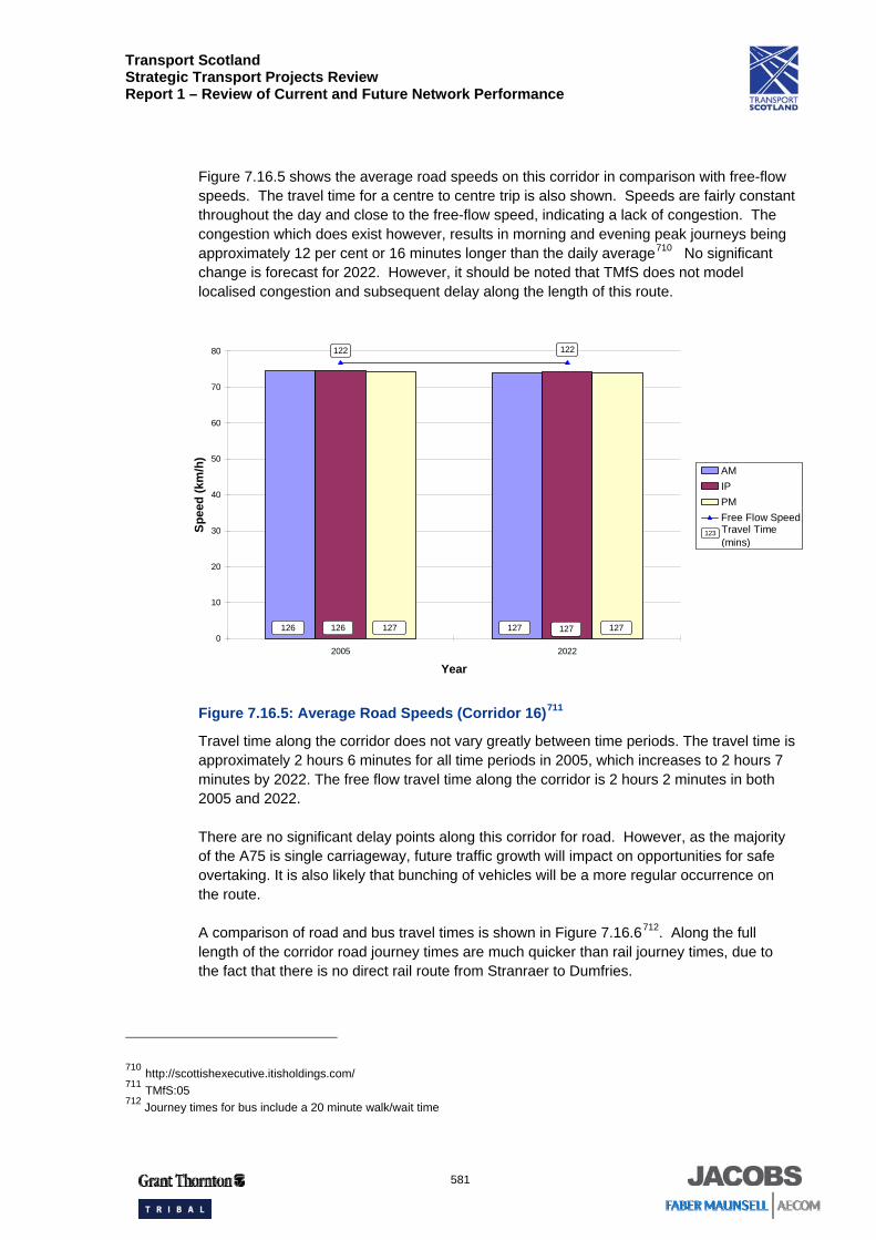
Figure 7.16.5 shows the average road speeds on this corridor in comparison with free-flow speeds. The travel time for a centre to centre trip is also shown. Speeds are fairly constant throughout the day and close to the free-flow speed, indicating a lack of congestion. The congestion which does exist however, results in morning and evening peak journeys being approximately 12 per cent or 16 minutes longer than the daily average710 No significant change is forecast for 2022. However, it should be noted that TMfS does not model localised congestion and subsequent delay along the length of this route.
Figure 7.16.5: Average Road Speeds (Corridor 16)711
Travel time along the corridor does not vary greatly between time periods. The travel time is approximately 2 hours 6 minutes for all time periods in 2005, which increases to 2 hours 7 minutes by 2022. The free flow travel time along the corridor is 2 hours 2 minutes in both 2005 and 2022.
There are no significant delay points along this corridor for road. However, as the majority of the A75 is single carriageway, future traffic growth will impact on opportunities for safe overtaking. It is also likely that bunching of vehicles will be a more regular occurrence on the route.
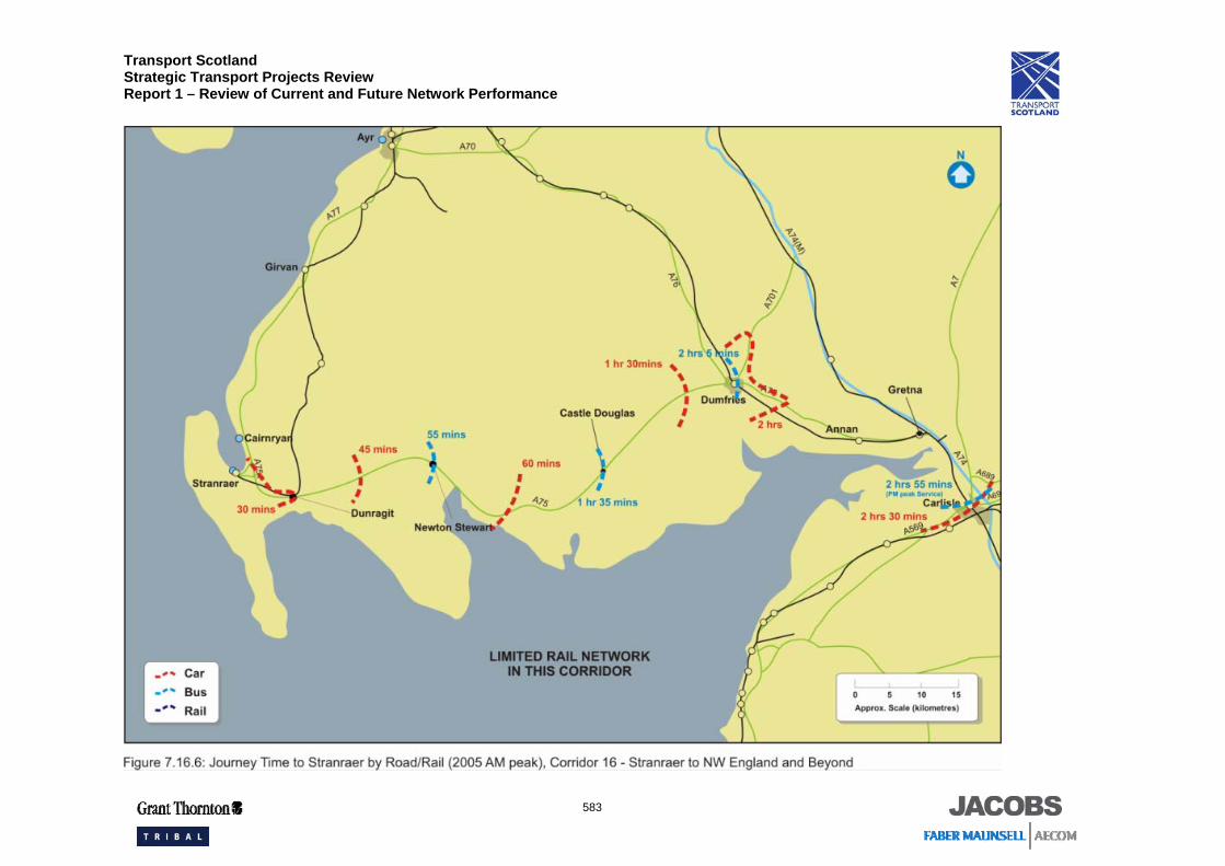
A comparison of road and bus travel times is shown in Figure 7.16.6712. Along the full length of the corridor road journey times are much quicker than rail journey times, due to the fact that there is no direct rail route from Stranraer to Dumfries.
710 http://scottishexecutive.itisholdings.com/ 711 TMfS:05 712 Journey times for bus include a 20 minute walk/wait time
0
10
20
30
40
50
60
70
80
2005 2022
Year
Spee
d (k
m/h
)
AMIPPMFree Flow Speed
127 127127127126 126
Travel Time(mins)
123
122122
Transport Scotland Strategic Transport Projects Review Report 1 – Review of Current and Future Network Performance
582
The travel time from Stranraer to Dumfries by bus is one hour longer than the equivalent car journey due to the bus services stopping in the many settlements along the route.
Transport Scotland Strategic Transport Projects Review Report 1 – Review of Current and Future Network Performance
583
Transport Scotland Strategic Transport Projects Review Report 1 – Review of Current and Future Network Performance
584
Overall, the road network in this corridor is operating effectively with flows well within design capacity. However, there are limited overtaking opportunities due to the A75 being predominately single carriageway. Speeds are reasonable, given the nature of the road network and the high number of HGVs using it, largely transporting freight between Northern Ireland and England. Ferry related HGV traffic may cause a bunching effect, further reducing overtaking opportunities and affecting the journey time reliability for other road users. The programmed road improvements along the A75 will help to address this issue.
Rail service reliability is measured as the percentage of trains actually run in the last 12 months, split into seven service groups. The reliability of the services in Corridor 16 is:
• First ScotRail South West 91.8 per cent (target 92 per cent)713.
There is localised overcrowding on peak services at Dumfries, Annan and Gretna Green. The rail line serving Stranraer is single track and trains are infrequent. Rail journeys along the whole length of the corridor require interchanges and have a circuitous route resulting in uncompetitive journey times.
Emissions (CO2 only)
This section of the report addresses the issue:
• What is the level of transport based emissions within the corridor?
CO2 per person kilometre is forecast to rise from 147 tonnes / million person kilometres to 156 tonnes / million person kilometres between 2005 and 2022 in this corridor. This is a result of CO2 emissions rising at a slightly greater rate than person kilometres between 2005 and 2022714.
The road based transport network produced 131,500 tonnes of CO2 in Corridor 16 in 2005. This equates to two per cent of the total road based transport related CO2 emissions in Scotland.
By 2022, it is forecast that CO2 emissions in Corridor 16 will rise to around 148,500 tonnes, approximately two per cent of Scotland’s road based transport related CO2 emissions in 2022.
713 http://www.firstgroup.com/scotrail/content/aboutus/ourperformance.php 714 TMfS:05
Transport Scotland Strategic Transport Projects Review Report 1 – Review of Current and Future Network Performance
585
Quality / Accessibility / Affordability
The following paragraphs address the issues of:
• Does public transport provision match origin / destination analysis? • How competitive is public transport compared with the car? • Do capacity issues impact on public transport service? • How safe is the network?
There are limited rail services operating between Stranraer and North West England, with one through train per day and a change of train required at other times. Bus infrastructure is in place, but irregular services and impractical travel times do therefore not provide sufficient circumstances for effective business interaction between Stranraer and North West England.
Bus services in the corridor include commuter services from Newton Stewart to Stranraer and from Castle Douglas to Dumfries, longer distance services from Stranraer to Dumfries and beyond, and local services between the settlements in the corridor. There is no direct rail route in the corridor. Trips within the corridor account for over half of all trips. The poor public transport share indicates that it is uncompetitive, whether due to journey times or the difficulty of serving a dispersed population.
Both car and public transport accessibility are low, but car is generally more competitive. This is not forecast to change significantly in the future.
Table 7.16.2 provides an assessment of the quality of strategic bus services in the corridor on a scale of one to five, with one being ‘poor’ and five being ‘excellent’.
Table 7.16.2: Assessment of Bus Service Quality715
Service Operator Annual Journeys
Reliability Frequency Simplicity Value Coverage Vehicle Quality
79, 179, 500, X75
Stagecoach 21,600 3 4 4 3 4 4
There is localised overcrowding on services between Dumfries and Carlisle in the peak periods.
The accident and fatal accident rates on the A75 are both similar to the national rates for this road type. Initial analysis of severe accident clusters indicated safety issues at the A75 / A76 Junction on the Dumfries ring road and also on the A75 to the east of the dual section east of Dumfries. The combination of high relative speeds and limited overtaking potential on the mainly single carriageway road is likely to be a contributory factor716.
715 Bus Users UK (Qualititative Assessment – 1: very poor; 5: excellent) 716 Transport Scotland SERIS Database
Transport Scotland Strategic Transport Projects Review Report 1 – Review of Current and Future Network Performance
586
Summary of Infrastructure and Operational Constraints
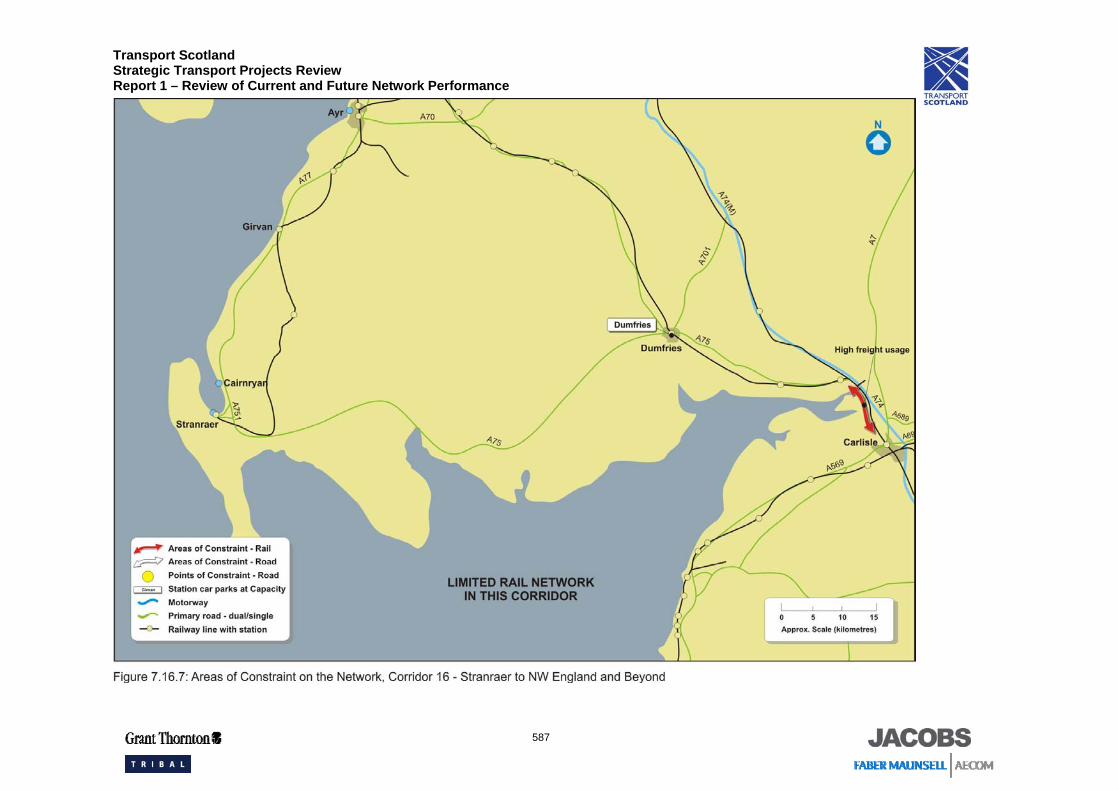
Key constraints and congestion points are shown in Figure 7.16.7, including:
• Paths for additional passenger services are restricted by the freight usage on railway line between Gretna Junction and Carlisle; and
• Paths for additional passenger services are restricted by long intermediate block signal sections.
Transport Scotland Strategic Transport Projects Review Report 1 – Review of Current and Future Network Performance
587
Transport Scotland Strategic Transport Projects Review Report 1 – Review of Current and Future Network Performance
588
7.16.5 Summary and Conclusions
Overall, how well does the transport network perform?
Overall the road network in this corridor is operating effectively and reliably. Speeds are reasonable given the nature of the road network, the relatively high proportion of HGVs, and the interaction with local traffic. However there are safety issues on the predominately single carriageway A75 with its limited overtaking opportunities. The high proportion of HGV ferry traffic can give rise to platooning of vehicles on the A75.
The corridor is poorly served by rail. The Stranraer to Carlisle rail journey is particularly circuitous. Dumfries railway station car park is often at full capacity and there is localised overcrowding on services between Dumfries and Carlisle. Overall there are very limited services available within this corridor with very few trains running combined with long journey times to North West England.
Bus transport is the main form of public transport in the corridor. The corridor’s bus network has a good rating in terms of providing frequent services which provide good coverage to rural areas. However, public transport links to major Scottish cities are very poor.
Will the transport network meet future demand, particularly in areas of economic activity?
Increased traffic flows are forecast on the road network in the corridor but they will still be within its design capacity.
It is expected that rail passengers may have to stand on the Carlisle to Dumfries service in the morning peak with the busiest section being between Carlisle and Annan. There are no expected carrying capacity issues highlighted in the evening peak on the rail network.
What are the key drivers that will impact on performance in the future?
Whilst the population is forecast to remain unchanged between 2005 and 2022 the number of households in the area is forecast to increase with much of the pressure for housing development concentrated in the larger towns such as Dumfries, Stranraer and Annan which also act as employment and service centres.
The increasingly important role played by tourism, as well as timber extraction, is expected to influence the local economy to a much greater extent.
What are the key problems associated with delivering the KSOs?
Overcrowding on the rail network between Carlisle and Dumfries in the morning peak and the associated additional carrying capacity required to accommodate the forecast growth in demand are likely problems for rail. With no direct service to Prestwick Airport from Dumfries, passengers have to travel via Glasgow or Kilmarnock.