Embed Size (px)
Citation preview
Transport Scotland Strategic Transport Projects Review Report 1 – Review of Current and Future Network Performance
384
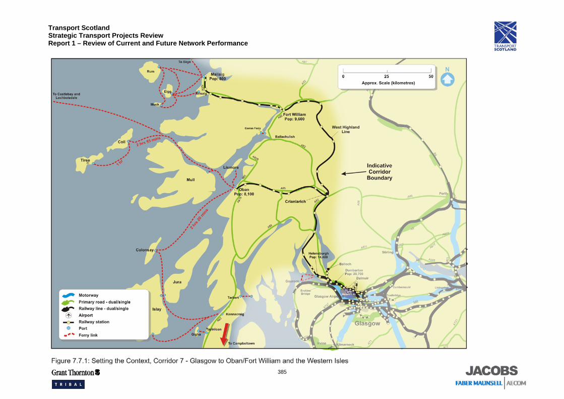
7.7 Corridor 7: Glasgow to Oban / Fort William and Western Isles
7.7.1 Setting the Context
Corridor 7 extends from the outskirts of Glasgow to Oban, Fort William, Mallaig and Campbeltown. It encompasses West Dunbartonshire and Argyll and Bute from Loch Lomond and the Trossachs in the east to the Kintyre peninsula and the islands off the west coast including Mull and Skye, as shown in Figure 7.7.1. The corridor provides an important link to areas north of Fort William, as well as Skye and the Western Isles, from the Central Belt. The south east area of the corridor is more densely populated, around the main towns of Dumbarton and Helensburgh, while from Loch Lomond northwards, the mountainous terrain is sparsely populated until the coastal towns of Oban and Fort William. It is approximately 154 kilometres between Glasgow and Oban.
A key corporate priority of West Dunbartonshire Council is to regenerate its three main town centres, including Dumbarton and its related waterfront. Clydebank, a former centre of industry, is now a development area within the West Dunbartonshire area460, indeed it has been identified it as a national priority461. This development will reclaim Clydebank for communities by developing mixed-use developments, including up to 10,000 additional homes which include the area of Dumbarton. The development will also capitalise upon the rail, ferry and cycleway network that serve the river frontage462. In addition, the redevelopment of Dumbarton town centre aims to provide new jobs by supplying more retail and office space and to increase the number of residential units within the town centre area463.
Argyll and Bute’s traditional industries are forestry, agriculture, fishing and tourism464. The economy of Argyll and Bute is predominantly service based, with the public sector as the largest employer. There is a higher than average percentage of jobs in the hospitality, agriculture, whisky, forestry, hunting and fishing sectors. This is in part due to the natural resources of the area and its established reputation as a holiday destination.
460 Clydebank Local Plan September 2004 461 People and Place: Regeneration Policy Statement, Scottish Executive, 2006 462 Glasgow and Clyde Valley Joint Structure Plan: Written Statement April 2006 463 Dumbarton Town Centre Masterplan: Consultants Brief March 2007 & West Dunbartonshire Council www.wdcweb.info 464 Argyll and Bute Local Plan June 2006
Transport Scotland Strategic Transport Projects Review Report 1 – Review of Current and Future Network Performance
385
Transport Scotland Strategic Transport Projects Review Report 1 – Review of Current and Future Network Performance
386
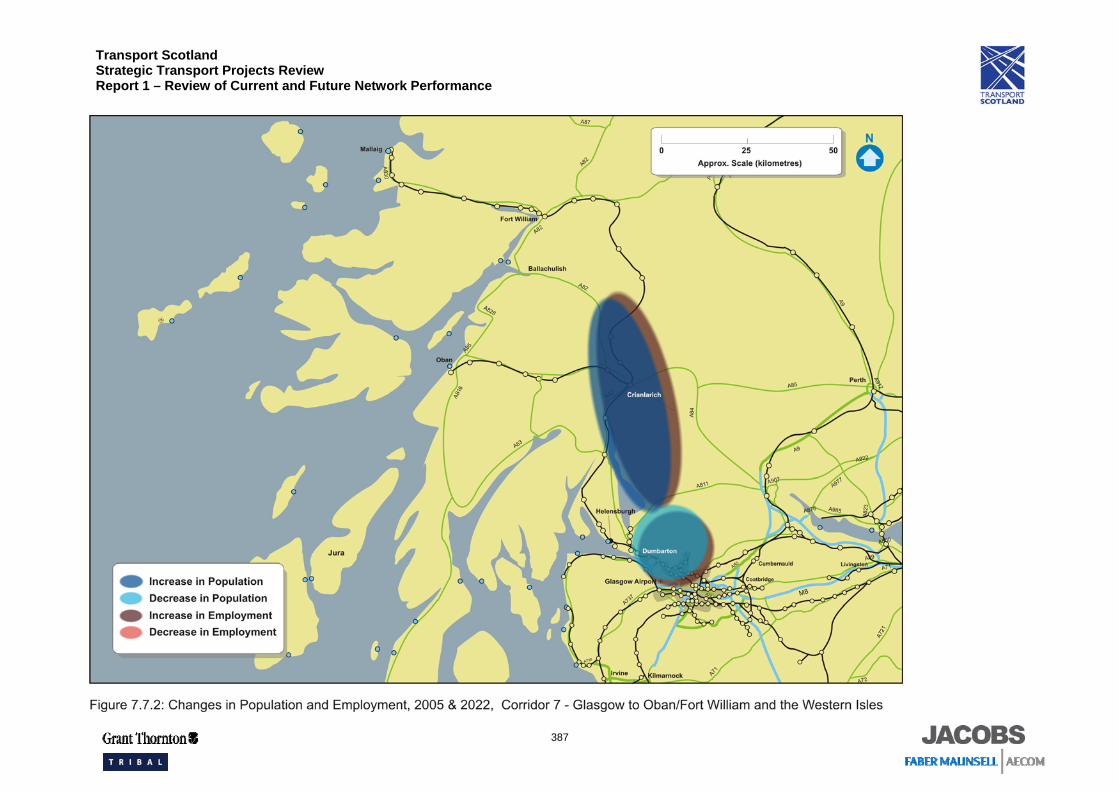
Figure 7.7.2 shows the expected areas of change in population and employment. The population of the main settlements in the corridor was over 150,000 in 2006465. In the Highland and Argyll and Bute council areas, the population is projected to increase by almost four per cent by 2024, while in West Dunbartonshire it is expected to decline by almost nine per cent over the same period466. A concurrent increase in the number of households indicates a continuing reduction in household size467.
It is expected that there will be an increase in employment within the Argyll and Bute council area of nine per cent compared to a one per cent increase in the West Dunbartonshire area by 2022468. The economic inactivity rate in West Dunbartonshire is 24 per cent, higher than the national rate of 21 per cent, whereas in Argyll and Bute it is slightly lower at 19 per cent469. Income levels for the corridor range are £364 per week in West Dunbartonshire, £393 per week in Argyll and Bute and £386 in the Highlands. This equates to 88 per cent, 96 per cent and 94 per cent respectively of the average for Scotland (£412)470.
Car ownership in the corridor, measured as a percentage of households with access to a car, varies, with the more urbanised areas in the south of the corridor below the national average of 67 per cent, while the more rural areas to the north and west have a higher percentage, reflecting a greater dependence on the car:
• West Dunbartonshire: 57 per cent; • Argyll and Bute: 72 per cent; and • Highland: 75 per cent471.
465 General Register for Scotland Mid-2006 population estimates for administrative areas: http://www.gro-scotland.gov.uk/files1/stats/06mype-cahb-t2-revised.xls 466 General Register Office for Scotland 2004-based Population Projections 467 National Planning Framework for Scotland, 2002 468 Scotland Planning Assessment Part 1 Report Volume 2 (Drivers of Change) October 2005 Table A2 469 Scottish Economic Statistics 2006, table 4.3 470 Scottish Economic Statistics 2006, table 4.20 471 Scotland’s Census 2001, www.scrol.gov.uk, Table KS17
Transport Scotland Strategic Transport Projects Review Report 1 – Review of Current and Future Network Performance
387
Transport Scotland Strategic Transport Projects Review Report 1 – Review of Current and Future Network Performance
388
7.7.2 Transport Network and Operations
Infrastructure and Services
The principal elements of the transport network that play a national strategic role are shown in Figure 7.7.1.
The A82 Trunk Road is the main spine of the road network between Glasgow and Fort William. The road is a two-lane dual carriageway from Glasgow to Balloch and is then single carriageway to Fort William. Other important elements of the road network include: • A85 Trunk Road, a single carriageway linking Oban and Crianlarich; • A83 Trunk Road, a single carriageway linking Campbeltown and Tarbet; • A828, a single carriageway linking Oban and Ballachulish; and • A898, the Erskine Bridge, linking the A82 across the Clyde to the M8 and Glasgow
Airport. The A830 Arisaig to Loch nan Uamh single track widening project has recently been completed thus upgrading the last section of single carriageway trunk road in Scotland. The south east area of the corridor is well served by electrified rail services from Glasgow to Dumbarton, Helensburgh and Balloch. The line is double track except for the Balloch branch, which is single track after Dumbarton. Diesel trains serve the rest of the corridor, operating the West Highland Line from Glasgow to Helensburgh, Crianlarich, Oban, Fort William and Mallaig. North of Helensburgh, the line is single track with passing loops.
Service patterns are generally:
• Three trains per day between Glasgow and Fort William;
• Three trains per day between Glasgow and Oban;
• Two trains per hour between Glasgow and Balloch;
• Two trains per hour between Glasgow and Helensburgh;
• One train per day between Edinburgh and Fort William which includes sleeper coaches from London Euston; and
• One freight service per day between Fort William and Mossend.
Bus services in the corridor include commuter services to Glasgow from the Helensburgh and Dumbarton areas, longer distance services from Fort William, Oban and Campbeltown and lifeline services between the settlements in the corridor. Service patterns are generally:
• One service every three hours between Glasgow and Fort William;
• Three services per day between Glasgow and Oban; and
• Three services per day between Glasgow and Campbeltown.
Transport Scotland Strategic Transport Projects Review Report 1 – Review of Current and Future Network Performance
389
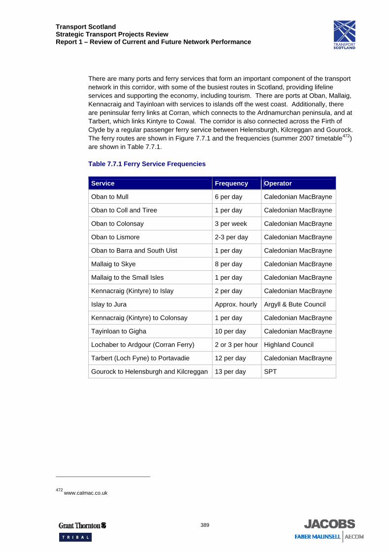
There are many ports and ferry services that form an important component of the transport network in this corridor, with some of the busiest routes in Scotland, providing lifeline services and supporting the economy, including tourism. There are ports at Oban, Mallaig, Kennacraig and Tayinloan with services to islands off the west coast. Additionally, there are peninsular ferry links at Corran, which connects to the Ardnamurchan peninsula, and at Tarbert, which links Kintyre to Cowal. The corridor is also connected across the Firth of Clyde by a regular passenger ferry service between Helensburgh, Kilcreggan and Gourock. The ferry routes are shown in Figure 7.7.1 and the frequencies (summer 2007 timetable472) are shown in Table 7.7.1.
Table 7.7.1 Ferry Service Frequencies
Service Frequency Operator
Oban to Mull 6 per day Caledonian MacBrayne
Oban to Coll and Tiree 1 per day Caledonian MacBrayne
Oban to Colonsay 3 per week Caledonian MacBrayne
Oban to Lismore 2-3 per day Caledonian MacBrayne
Oban to Barra and South Uist 1 per day Caledonian MacBrayne
Mallaig to Skye 8 per day Caledonian MacBrayne
Mallaig to the Small Isles 1 per day Caledonian MacBrayne
Kennacraig (Kintyre) to Islay 2 per day Caledonian MacBrayne
Islay to Jura Approx. hourly Argyll & Bute Council
Kennacraig (Kintyre) to Colonsay 1 per day Caledonian MacBrayne
Tayinloan to Gigha 10 per day Caledonian MacBrayne
Lochaber to Ardgour (Corran Ferry) 2 or 3 per hour Highland Council
Tarbert (Loch Fyne) to Portavadie 12 per day Caledonian MacBrayne
Gourock to Helensburgh and Kilcreggan 13 per day SPT
472 www.calmac.co.uk
Transport Scotland Strategic Transport Projects Review Report 1 – Review of Current and Future Network Performance
390
Glensanda is a major port for aggregate exports but there are no significant land-based movements associated with this. Campbeltown is a significant producer of wind turbine components so there are a number of oversize freight loads using the A83 / A82 route on a regular basis.
The corridor provides access to three minor airports at Campbeltown, Islay and Tiree, which offer scheduled flights to Glasgow. Campbeltown and Islay have two flights per day per direction while Tiree has one per day.
The principal interchange locations on the corridor are:
• Dalmuir (interchange between rail services) • Oban and Mallaig (interchange between rail and ferry to Western Isles); • Helensburgh (interchange between rail and ferry to Kilcreggan and Gourock); and • Fort William (interchange between rail and buses to Inverness). Glasgow city centre and Partick (located in the west end of Glasgow) also both act as interchange points between rail, bus and the subway for trips between Corridor 7 and other corridors, however these are within the Glasgow Urban Network.
Integrated tickets in the corridor are available in the form of the PLUSBUS ticket and the SPT ZoneCard. PLUSBUS covers rail journeys into Glasgow and Fort William and provides the addition of unlimited bus travel within the destination. The SPT ZoneCard is widely used and gives unlimited travel on bus, rail, subway and certain ferry services within designated zones in the SPT area, which covers the south east section of the corridor.
Asset Management
In 2007, nine per cent of the trunk road network pavement473 in this corridor is judged to require structural strengthening as it has no theoretical residual strength. This compares with a national level of four per cent474. Under Transport Scotland’s planned maintenance schedule, the net figure for the corridor is expected to fall to six per cent by 2012.
Further details on asset management, including bus and rail, are provided in Chapter 4.
Demand Management
The only bus priority measures within the corridor are on the approach to Glasgow. Glasgow City Council, in partnership with First Glasgow, SPT and West Dunbartonshire Council, have introduced quality bus corridors between Knightswood and Glasgow city centre along the A82 and between Faifley, Clydebank and Glasgow city centre, and these are dealt with in more detail within the Glasgow Urban Network.
473 Transport Scotland SERIS Database 474 STS No. 25 (2006) Table 5.5
Transport Scotland Strategic Transport Projects Review Report 1 – Review of Current and Future Network Performance
391
Glasgow City Council has adopted a policy of discouraging parking provision within the city centre for commuters to encourage public transport use. Car parking spaces are available at several railway stations on the corridor.
Programmed Schemes
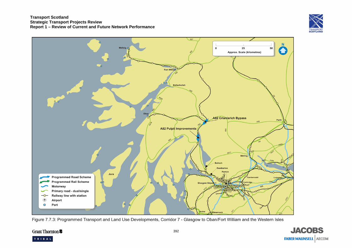
The programmed schemes in the corridor are shown in Figure 7.7.3:
• A82 Crianlarich Bypass; • A82 Loch Lomondside improvements at Pulpit Rock; and • Improvements to Class 156 rolling stock.
Transport Scotland Strategic Transport Projects Review Report 1 – Review of Current and Future Network Performance
392
Transport Scotland Strategic Transport Projects Review Report 1 – Review of Current and Future Network Performance
393
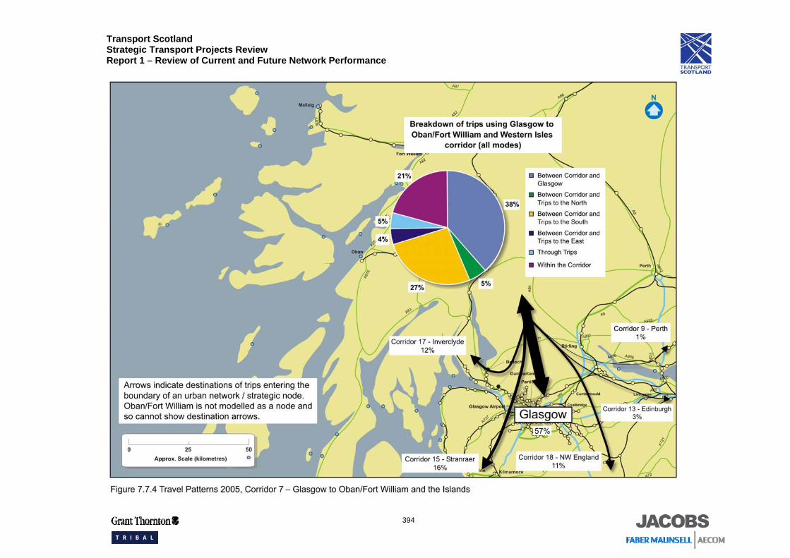
7.7.3 Travel Patterns
As the area is not completely covered by the current TMfS, the approach taken has been to provide a review of travel patterns using the initial output from TMfS:05, supplemented with additional data from the TMfS:05H where appropriate. Demand growth has been based on National Road Traffic Forecasts.
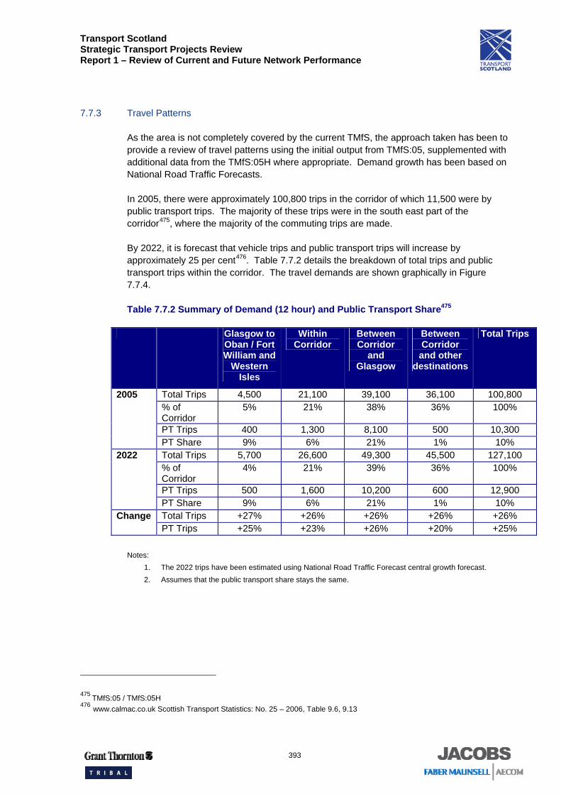
In 2005, there were approximately 100,800 trips in the corridor of which 11,500 were by public transport trips. The majority of these trips were in the south east part of the corridor475, where the majority of the commuting trips are made.
By 2022, it is forecast that vehicle trips and public transport trips will increase by approximately 25 per cent476. Table 7.7.2 details the breakdown of total trips and public transport trips within the corridor. The travel demands are shown graphically in Figure 7.7.4.
Table 7.7.2 Summary of Demand (12 hour) and Public Transport Share475
Glasgow to Oban / Fort William and
Western Isles
Within Corridor
Between Corridor
and Glasgow
Between Corridor and other
destinations
Total Trips
Total Trips 4,500 21,100 39,100 36,100 100,800 % of Corridor
5% 21% 38% 36% 100%
PT Trips 400 1,300 8,100 500 10,300
2005
PT Share 9% 6% 21% 1% 10% Total Trips 5,700 26,600 49,300 45,500 127,100 % of Corridor
4% 21% 39% 36% 100%
PT Trips 500 1,600 10,200 600 12,900
2022
PT Share 9% 6% 21% 1% 10% Total Trips +27% +26% +26% +26% +26% Change PT Trips +25% +23% +26% +20% +25%
Notes:
1. The 2022 trips have been estimated using National Road Traffic Forecast central growth forecast. 2. Assumes that the public transport share stays the same.
475 TMfS:05 / TMfS:05H 476 www.calmac.co.uk Scottish Transport Statistics: No. 25 – 2006, Table 9.6, 9.13
Transport Scotland Strategic Transport Projects Review Report 1 – Review of Current and Future Network Performance
394
Transport Scotland Strategic Transport Projects Review Report 1 – Review of Current and Future Network Performance
395
The dominant travel demand is in the south of the corridor, with two thirds of trips being from the urban areas in West Dunbartonshire to and through Glasgow. Over a third of the trips are between the corridor and Glasgow. The next largest demand is between the corridor and towards the south and to Edinburgh. Travel demand in the more remote parts of the corridor is local, including tourist trips between settlements in the corridor and to ports for ferry connections.
Between the corridor and Glasgow, public transport usage is 21 per cent, which reflects the good bus and rail services in the urbanised south east part of the corridor. The level of public transport use in the corridor as a whole is about 10 per cent, reflecting the mainly rural nature of the corridor and the dispersed population. One third of trips are made between locations in the corridor and areas outside the corridor, beyond Glasgow and east towards Perth and Dundee. The public transport share for those movements is very low at only one per cent, which is considered to be due to the lack of available competitive public transport services directly to these locations. The West Highland Line is popular with tourists, particularly in the summer months, although on an annual basis, it accounts for less than 10 per cent of rail trips in the corridor. Tourism in the area also has a significant seasonal impact on the roads.
ATC data from the SRTDb gives a figure of approximately ten per cent HGV traffic on the A82 at Ballachulish, and of thirteen per cent HGV traffic on the A83 at Ardrishaig477.
The railway stations in the corridor have a total throughput of some 11.5 million passengers per annum (2005), with Partick the busiest station478.
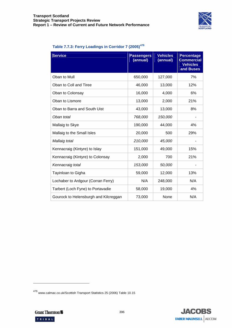
Ferry passenger and car numbers for 2005 are detailed in Table 7.7.3.
477 SRTDb 478 Rail industry LENNON data (Station Usage 2004/2005) The total rail passenger trips do not include SPT zonecard trips
Transport Scotland Strategic Transport Projects Review Report 1 – Review of Current and Future Network Performance
396
Table 7.7.3: Ferry Loadings in Corridor 7 (2005)479
Service Passengers (annual)
Vehicles (annual)
Percentage Commercial
Vehicles and Buses
Oban to Mull 650,000 127,000 7%
Oban to Coll and Tiree 46,000 13,000 12%
Oban to Colonsay 16,000 4,000 6%
Oban to Lismore 13,000 2,000 21%
Oban to Barra and South Uist 43,000 13,000 8%
Oban total 768,000 150,000 -
Mallaig to Skye 190,000 44,000 4%
Mallaig to the Small Isles 20,000 500 29%
Mallaig total 210,000 45,000 -
Kennacraig (Kintyre) to Islay 151,000 49,000 15%
Kennacraig (Kintyre) to Colonsay 2,000 700 21%
Kennacraig total 153,000 50,000 -
Tayinloan to Gigha 59,000 12,000 13%
Lochaber to Ardgour (Corran Ferry) N/A 248,000 N/A
Tarbert (Loch Fyne) to Portavadie 58,000 19,000 4%
Gourock to Helensburgh and Kilcreggan 73,000 None N/A
479 www.calmac.co.uk/Scottish Transport Statistics 25 (2006) Table 10.15
Transport Scotland Strategic Transport Projects Review Report 1 – Review of Current and Future Network Performance
397
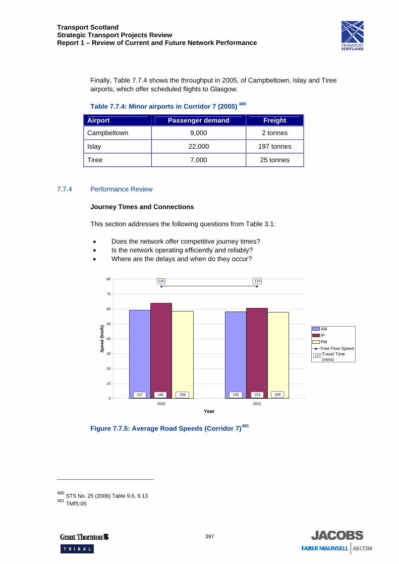
Finally, Table 7.7.4 shows the throughput in 2005, of Campbeltown, Islay and Tiree airports, which offer scheduled flights to Glasgow.
Table 7.7.4: Minor airports in Corridor 7 (2005) 480
Airport Passenger demand Freight
Campbeltown 9,000 2 tonnes
Islay 22,000 197 tonnes
Tiree 7,000 25 tonnes
7.7.4 Performance Review
Journey Times and Connections
This section addresses the following questions from Table 3.1:
• Does the network offer competitive journey times? • Is the network operating efficiently and reliably? • Where are the delays and when do they occur?
Figure 7.7.5: Average Road Speeds (Corridor 7)481
480 STS No. 25 (2006) Table 9.6, 9.13 481 TMfS:05
0
10
20
30
40
50
60
70
80
2005 2022
Year
Spee
d (k
m/h
)
AMIPPMFree Flow Speed
158 160153159157 145
Travel Time(mins)
123
124125
Transport Scotland Strategic Transport Projects Review Report 1 – Review of Current and Future Network Performance
398
Travel time to Oban along the corridor is 2 hours 25 minutes, 2 hours 37 minutes and 2 hours 38 minutes for the off peak, morning peak and evening peak respectively. By 2022 the morning and evening peak are relatively unchanged at 2 hours 39 minutes and 2 hours 40 minutes respectively, however the off peak increases to 2 hours 33 minutes, bringing it more in-line with the morning and evening peak travel times. The free flow travel time reduces slightly from 2 hours 5 minutes to 2 hours 4 minutes between 2005 and 2022.
The A82 between Erskine Bridge and Dumbarton currently experiences congestion that affects journey times, particularly in the peaks. Although the AADT flow (44,000 vehicles)482 is within the theoretical design capacity for this dual carriageway road, interaction of local traffic and the presence of numerous at-grade junctions reduce the efficiency of the road and increase journey times. As traffic volumes increase in future years, so will congestion and thus journey times are likely to be adversely affected. It is forecast that increased congestion will impact the south east section of the corridor due to the higher demand, particularly the commuting element towards Glasgow.
Over the northern part of the corridor, for most of the year the traffic volumes (around 2,000 – 5,000) are within the capacity of the roads and the average speeds are reasonable. However, there is notable congestion during the busy tourist season, particularly from Loch Lomond northwards. Traffic volumes on the A82 can increase by between 30 per cent and 60 per cent in the summer months compared to January483. As the roads go through many of the settlements in the corridor, the speed restriction in each has an effect on the overall journey time.
Delays at the A82 / A85 junction in Crianlarich are also a constraint on the A82. Plans for a Crianlarich Bypass are programmed, which would relieve this constraint484.
Summer traffic also includes many more coaches and caravans. As these tend to travel more slowly, and are more difficult to overtake on these types of roads, journey times are adversely affected.
Much of the freight in this corridor is associated with the agriculture, whisky, fishing and forestry industries and almost all of it is carried on road. There are rail freight services associated with the aluminium smelting plant in Fort William. Again this will affect journey times for other traffic as the roads are single carriageway with limited overtaking opportunities.
482 SRTDb 483 Transport Scotland Scottish Roads Traffic Database 484 A82 Tarbet to Fort William Route Action Plan Study, Scott Wilson
Transport Scotland Strategic Transport Projects Review Report 1 – Review of Current and Future Network Performance
399
The difficult road alignment, due to the topography of the area, and the consequential poor visibility and lack of overtaking opportunities, will cause journey times to vary in this corridor and parts of the A82 and A83 are also susceptible to landslips. However, only a few journeys will face reliability problems and most of these journeys are concentrated within the Glasgow area485. Journey time reliability issues mean that during the morning and evening peaks, journey times are approximately 11 per cent or 13 minutes longer than the daily average486. There is a location on Loch Lomondside where traffic signals control one way flow through tight corners on narrow roads. The A82 Route Action Plan identifies various potential improvements, which would consist of approximately 30 kilometres of road improvements and a 400m tunnel487.
The mix of freight and tourist traffic can exacerbate the situation, as can seasonal fluctuations. Given the number of ferry ports in the corridor, and the importance of making timely connections, certainty of journey time is of particular importance here.
Travelling from Glasgow to Campbeltown by road takes approximately 3 hours and 20 minutes over a distance of 134 miles. Whilst travelling from Oban to Campbeltown by road takes around 2 hours and 10 minutes over a distance of 88 miles488. The average speed of each journey is approximately 40mph. This is considered reasonable for average travel speed on a single carriageway, however this is low over a long journey.
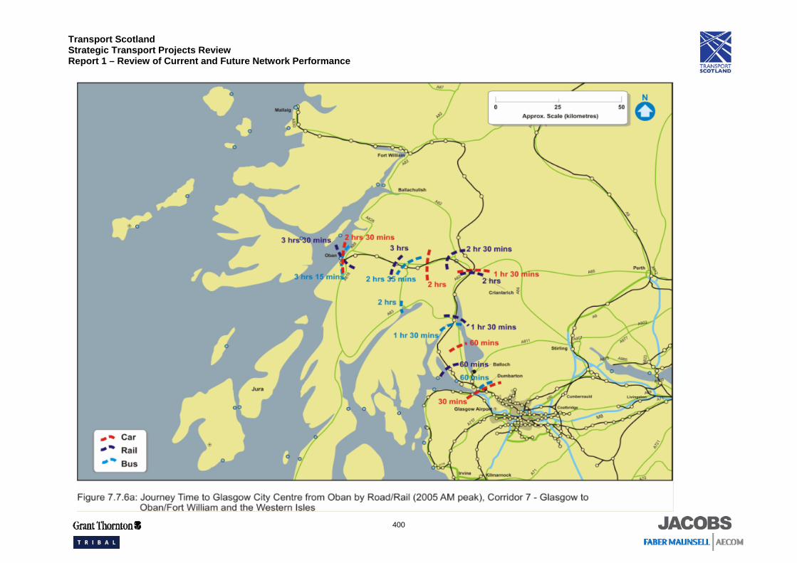
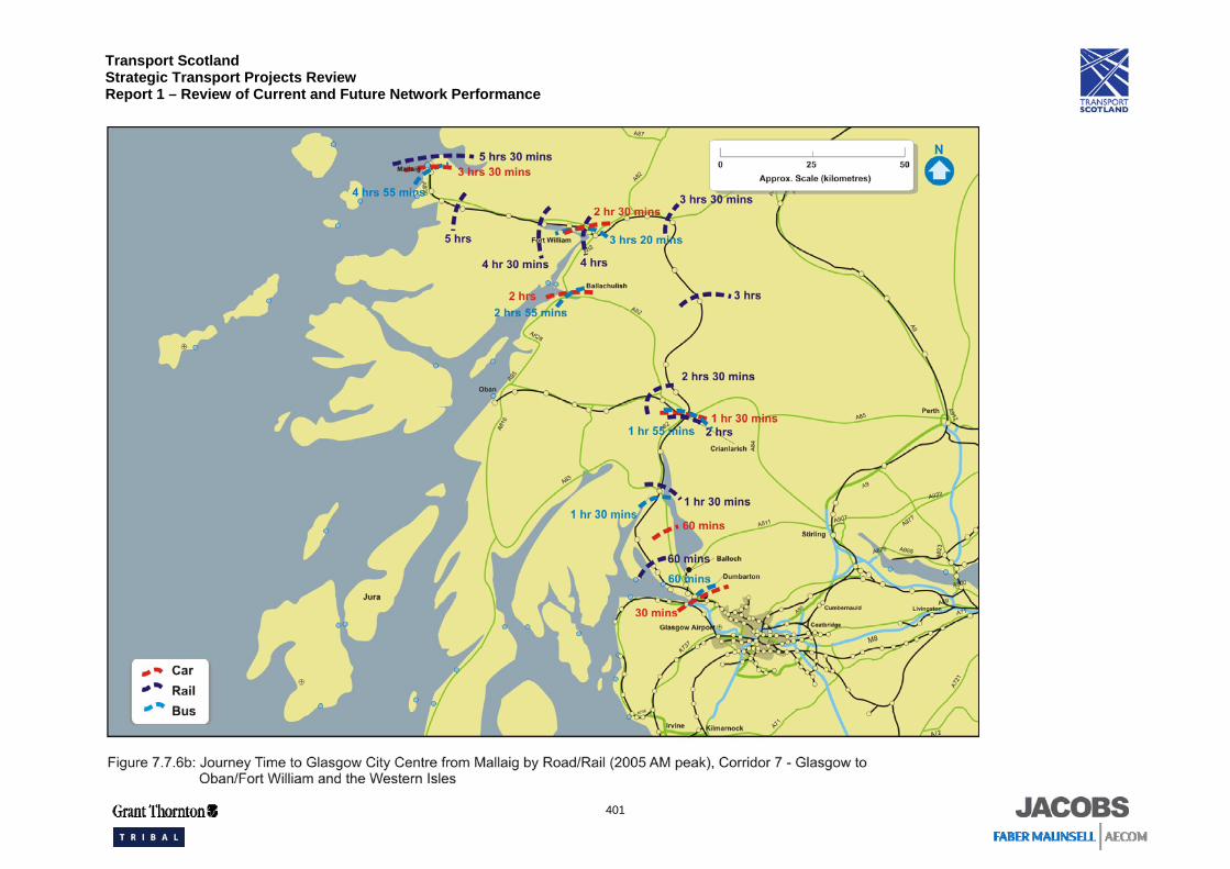
A comparison of road, bus and rail travel times during the morning peak is shown in Figure 7.7.6a and 7.7.6b489 for trips to Glasgow from Oban and Mallaig respectively. This indicates that rail journeys are considerably longer than those by road and do not offer a competitive alternative over most of the corridor. Travelling to Fort William by rail can take an hour longer than by car. The train service pattern is also irregular.
485 TMfS:05 486 http://scottishexecutive.itisholdings.com/ 487 A82 Tarbet to Fort William Route Action Plan Study, Scott Wilson 488 Moving Forward, Argyll and Bute Council, Local Transport Strategy 2007-2010 489 Journey times for bus/rail include a 20 minute walk/wait time
Transport Scotland Strategic Transport Projects Review Report 1 – Review of Current and Future Network Performance
400
Transport Scotland Strategic Transport Projects Review Report 1 – Review of Current and Future Network Performance
401
Transport Scotland Strategic Transport Projects Review Report 1 – Review of Current and Future Network Performance
402
Due to the topography, the railway line takes a circuitous route along the corridor and finally approaches Fort William from the northeast. The line is single track throughout with passing loops at stations. Due to the topography and current infrastructure condition on this route, the speed limit varies between 50 kilometres per hour (30mph) and 70 kilometres per hour (45mph). These factors, and the gradients involved, contribute to the long journey by rail.
The nature of the track layout and signaling system on the West Highland Line constrains the opportunities to improve the timetable or provide additional services. In the south of the corridor, the intensity of the electric services constrain the opportunity for faster and more frequent long distance trains. On the approach to Glasgow Queen Street low level and Glasgow Central low level, the line between Finnieston and Hyndland is constrained where two lines merge and then separate again. This capacity constraint affects services to Balloch, Dumbarton and Helensburgh Central, but not to Oban, Fort William or Mallaig. Capacity constraints within Glasgow are discussed in more detail within the Glasgow Urban Network.
Bus journeys on most routes are affected by road congestion to the same extent as the car, however due to the number of stops and slower speed, bus is not competitive with car.
Some of the railway station car parks are currently operating at or close to capacity490, which is likely to influence future demand to travel by train.
Emissions (CO2 only)
This section of the report addresses the issue:
• What is the level of transport based emissions within the corridor?
CO2 per person kilometre is forecast to rise from 126 tonnes / million person kilometres to 142 tonnes / million person kilometres between 2005 and 2022 in this corridor491.
The road based transport network produced 163,000 tonnes of CO2 in Corridor 7 in 2005. This equates to approximately two per cent of the total road based transport related CO2 emissions in Scotland.
By 2022, it is forecast that CO2 emissions in Corridor 7 will rise to around 180,500 tonnes, approximately two per cent of Scotland’s road based transport related CO2 emissions in 2022.
The rail network produced 1,500 tonnes of CO2 in Corridor 7 in 2007. This equates to approximately two per cent of the total rail based CO2 emissions in Scotland492.
490 First ScotRail Station Facilities: www.firstgroup.com/scotrail 491 TMfS: 05 492 AEA (2001) Rail Emission Model Final Report; www.nationalrail.co.uk; and www.networkrail.co.uk
Transport Scotland Strategic Transport Projects Review Report 1 – Review of Current and Future Network Performance
403
Therefore, it is estimated that the road and rail based transport network collectively produced 164,500 tonnes of CO2 in Corridor 7 in 2005. This equates to approximately two per cent of the total road and rail based transport related CO2 emissions in Scotland.
Quality / Accessibility / Affordability
The following paragraphs address the issues of:
• Does public transport provision match origin/destination analysis? • How competitive is public transport compared with the car? • Do capacity issues impact on public transport service? • How safe is the network?
Bus services in the corridor include commuter services to Glasgow from the Helensburgh and Dumbarton areas, longer distance services from Glasgow to Fort William, Oban and Campbeltown and lifeline services between the settlements in the corridor. A greater number of services, both bus and rail, are available in the south east section of the corridor where demand to travel is higher.
Public transport accessibility is relatively high around Dumbarton, consistent with high levels of demand, although car travel remains more competitive. Further north, public transport accessibility is much less competitive. Increases in both public transport and (to a greater extent) car accessibility are forecast for the future around Dumbarton. These reflect new road and public transport schemes planned for the Glasgow conurbation.
There are people without cars in areas of West Dunbartonshire with a greater dependence on public transport to meet their needs. However, public transport accessibility in these areas is generally higher than average, suggesting that it does not contribute to social exclusion.
On the electrified rail services in the south east part of the corridor, the morning high peak loading factor is 0.89. Since this figure is averaged over a number of services, it suggests that some are already overcrowded.
There is a small bus station in Fort William which is adjacent to the railway station, however low journey frequencies reduce the level of integration available between the modes.
This lack of public transport commuting opportunities is potentially limits effective business interaction between and among the centres of this corridor. The distance between Inverness and either Oban or Fort William means that commuting by private car is not an attractive alternative.
Transport Scotland Strategic Transport Projects Review Report 1 – Review of Current and Future Network Performance
404
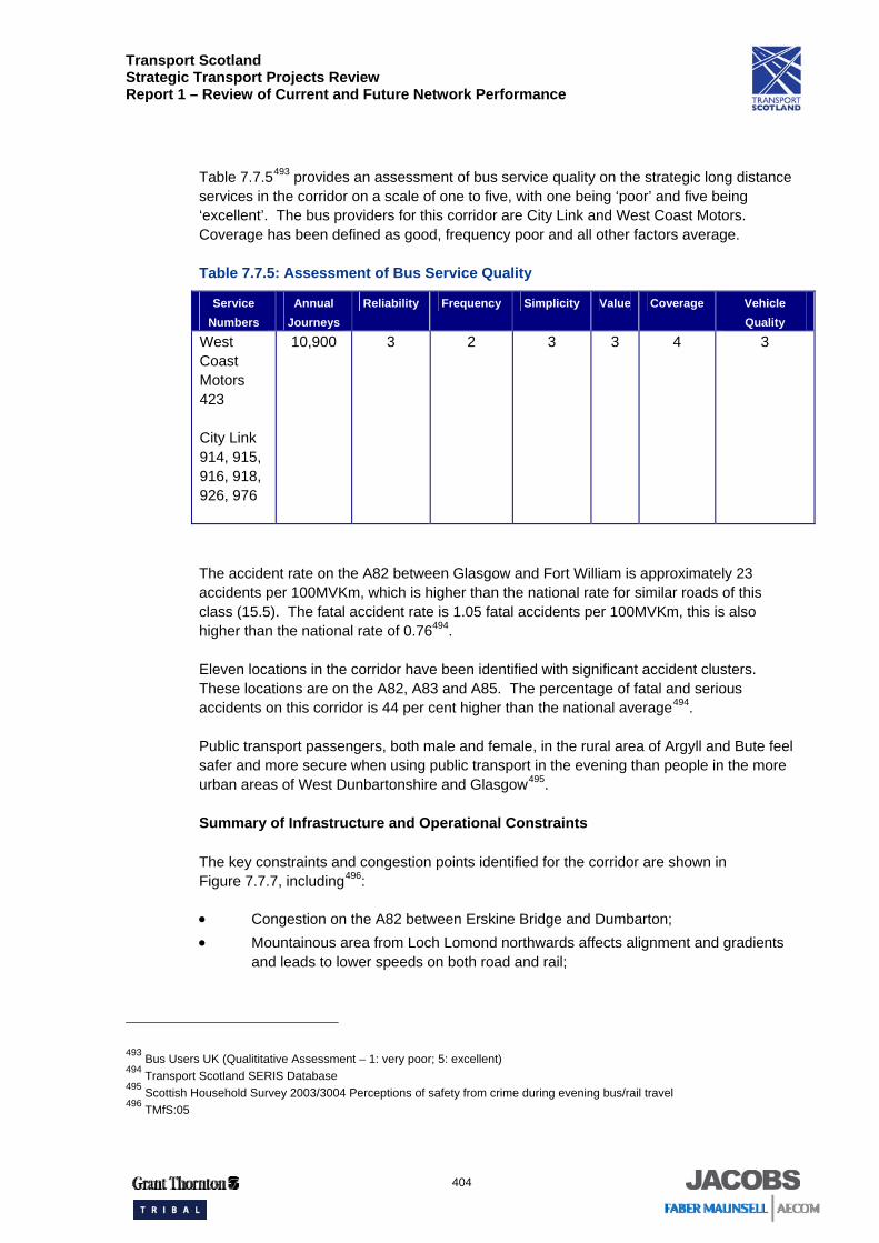
Table 7.7.5493 provides an assessment of bus service quality on the strategic long distance services in the corridor on a scale of one to five, with one being ‘poor’ and five being ‘excellent’. The bus providers for this corridor are City Link and West Coast Motors. Coverage has been defined as good, frequency poor and all other factors average.
Table 7.7.5: Assessment of Bus Service Quality
Service Numbers
Annual Journeys
Reliability Frequency Simplicity Value Coverage Vehicle Quality
West Coast Motors 423
City Link 914, 915, 916, 918, 926, 976
10,900 3 2 3 3 4 3
The accident rate on the A82 between Glasgow and Fort William is approximately 23 accidents per 100MVKm, which is higher than the national rate for similar roads of this class (15.5). The fatal accident rate is 1.05 fatal accidents per 100MVKm, this is also higher than the national rate of 0.76494.
Eleven locations in the corridor have been identified with significant accident clusters. These locations are on the A82, A83 and A85. The percentage of fatal and serious accidents on this corridor is 44 per cent higher than the national average494.
Public transport passengers, both male and female, in the rural area of Argyll and Bute feel safer and more secure when using public transport in the evening than people in the more urban areas of West Dunbartonshire and Glasgow495.
Summary of Infrastructure and Operational Constraints
The key constraints and congestion points identified for the corridor are shown in Figure 7.7.7, including496:
• Congestion on the A82 between Erskine Bridge and Dumbarton; • Mountainous area from Loch Lomond northwards affects alignment and gradients
and leads to lower speeds on both road and rail;
493 Bus Users UK (Qualititative Assessment – 1: very poor; 5: excellent) 494 Transport Scotland SERIS Database 495 Scottish Household Survey 2003/3004 Perceptions of safety from crime during evening bus/rail travel 496 TMfS:05
Transport Scotland Strategic Transport Projects Review Report 1 – Review of Current and Future Network Performance
405
• As traffic must pass through all settlements in the corridor north of Luss, speed restrictions and junctions affect the overall journey time;
• Single track railway with passing loops on the West Highland Line between Helensburgh and Fort William / Oban constrains capacity for additional services and other timetabling options;
• Speed restriction on railway line; • Intensive electric services constrain the opportunity for faster long distance trains;
and • Station car parks are usually full at Helensburgh, Fort William and Oban.
Transport Scotland Strategic Transport Projects Review Report 1 – Review of Current and Future Network Performance
406
Transport Scotland Strategic Transport Projects Review Report 1 – Review of Current and Future Network Performance
407
7.7.5 Summary and Conclusions
Overall, how well does the transport network perform?
There is some local peak congestion on the A82 between the Erskine Bridge and Dumbarton. Otherwise, the roads in this corridor operate reasonably effectively and reliably. While the roads operate freely for most of the year, there is localised congestion during the busy tourist season. The road alignment along this corridor, particularly north of Loch Lomond, restricts speed and reduces visibility. This is exacerbated by the vehicle mix on the road, a high proportion of HGVs and tourist coaches, particularly in summer, which are more difficult to overtake. Furthermore, as the road goes through most of the settlements in the corridor, the speed restrictions affect the overall journey time. Bus services are subject to the same effects on journey time.
The accident rate and the fatal accident rate on the A82 are both higher than the national average. Eleven accident clusters have also been identified on the A82, A83 and A85. Overall, the serious and fatal accident rate is higher than the national average.
Despite the restrictions on travel times by road, rail does not offer a competitive journey time. Factors such as a circuitous route and gradients, imposed by the topography, are compounded by a speed restrictions and a single track layout that restricts timetables, giving an unattractive journey time relative to road.
The electrified rail services from Glasgow to Balloch and Helensburgh are heavily used by commuters. Along this section, the route between Finnieston and Hyndland is currently constrained, restricting the capacity of rail services, although Network Rail is committed to improving this through revised stopping patterns and timetables.
At Oban and Mallaig, the ferry terminals are well integrated with bus services and railway stations. At Fort William, there is interchange between rail and bus services to Inverness.
Will the transport network meet future demand, particularly in areas of economic activity?
Average road speeds are forecast to remain reasonable and relatively unchanged. This indicates that the forecast traffic growth on the corridor will largely be accommodated within the design capacity. However, the existing congestion on the A82 between the Erskine Bridge and Dumbarton will worsen, affecting journey times of all road users including bus travel time. Some of the traffic growth in this area will be associated with the regeneration of Clydebank.
As the Erskine Bridge gives access to Glasgow Airport and to the area of economic activity adjacent to it, congestion will affect journey time reliability in accessing these important destinations.
In the northern part of the corridor, programmed road schemes will address some of the causes of delay. These are the A82 Crianlarich Bypass (removes delays at the A82 / A85 Junction), the A82 Loch Lomondside improvements at Pulpit Rock (removes delays from the signal controlled one lane section).
Transport Scotland Strategic Transport Projects Review Report 1 – Review of Current and Future Network Performance
408
The rail network in the south east part of the corridor can accommodate some growth although some train loadings are approaching capacity in the peaks. The intensity of the electric services constrain the opportunity for faster long distance trains. Capacity to increase frequency will be limited until the constraint between Hyndland and Finnieston is addressed.
Patronage is expected to increase on the West Highland Line. There is limited scope to increase capacity here as the single track formation and the signalling system constrain timetabling options.
What are the key drivers that will impact on performance in the future?
Changing demographics and employment patterns, allied with a reduction in household size, may lead to an increase in travel demand. This change is most marked in Argyll and Bute where the public transport system may be less able to cater for the trips.
The regeneration of Clydebank will also add to the demand on the transport system in that area.
What are the key problems associated with delivering the KSOs?
Addressing the capacity constraints on the rail network, throughout the corridor, will be important to make rail more competitive with car. Increasing the modal share for rail will help relieve congestion on the road, which will also benefit bus services. Meanwhile, for those trips that still go by road, journey times will continue to be affected by the road alignment and the lack of overtaking opportunities.
The identified issue of a high accident rate and accident clusters will continue to make safety a key driver for performance.
Between Glasgow and Fort William / Oban on the West Highland Line, the predominance of single track railway and the geography contribute towards restricting future timetable development. There are also car park capacity issues at the railway stations within this corridor.
The rural nature of much of the corridor is a significant challenge to improving accessibility and there are poor perceptions of safety on public transport.