Embed Size (px)
Citation preview

02/09/2011 1
THE STRATEGIC SIGNIFICANCE OF
GEOGRAPHICAL CHOKE POINTS
THE MASTER KEYS THAT CONTROL WORLD TRADE
With Inspiration from my dear friend Dr Shirish Bhave

02/09/2011 2
A Father was reading a magazine and his little daughter every now and then distracted him. To keep her busy, he tore one page on which was printed the map of the world. He tore it into pieces and asked her to go to her room and put them together to make the map again. He was sure she would take the whole day to get it done. But the little one came back within minutes with perfect map. When he asked how she could do it so quickly, she said, 'Oh Dad, there is a man's face on the other side of the paper. I made the face perfect to get the map right."" she ran outside to play leaving the father surprised..
Moral : There is always the other side to whatever we experience in this world. This story indirectly teaches a lesson..whenever we come across a challenge or a puzzling situation, look at the other side... You will be surprised to see an easy way to tackle the problem…
THE OTHER SIDE

02/09/2011 3
NADI CHIKITSHA

02/09/2011 4

02/09/2011 5
THE HUMAN MERIDIANS

02/09/2011 6
THE HUMAN MERIDIANS

02/09/2011 7
THE PRIME MERIDIAN

02/09/2011 8
THE PRIME MERIDIAN

02/09/2011 9
THE PRIME MERIDIAN

1002/09/2011
THE WORLD MAP

02/09/2011 11
THE GRAND CHESSBOARD

02/09/2011 12
DOG WITH CHOKE CHAIN

02/09/2011 13
THE CHOKE CHAIN

02/09/2011 14
THE 70:80:90 PRINCIPLE
70 % Water
80 % Population
90 % World Trade

Choke points are narrow international waterways where three characteristics are present.
1.The waterway should be narrow and capable of being closed off to both commercial and
military snipping.
2.There should be no readily available maritime route to utilize in the event of closure.
3.Finally, the choke point should be of considerable significance to at least several States.
There are seven “primary” choke points which seem to satisfy these criteria. These are
Gibraltar, Bab el Mandeb, Hormuz, the Danish and Turkish Straits, and the Suez and
Panama Canals. It also identifies eleven “secondary” choke points, where at least one of the
required characteristics is missing. The eleven include Dover, Bering and Magellan Straits,
as well as Malacca-Singapore and a number of others in the Western Pacific.
1502/09/2011
CHOKE POINTS

02/09/2011 16
The most important naval choke points were first identified by John Arbuthnot Fisher in his defense of continued British colonialism (important colonies in parentheses):
1.Hormuz Strait between Oman and Iran at the entrance to the Persian Gulf (UAE)
2.Strait of Malacca between Singapore and Indonesia
3.Bab-el-Mandeb passage from the Arabian Sea to the Red Sea (Yemen and Socotra)
4.Panama Canal and the Panama Pipeline connecting the Pacific and Atlantic Oceans
(British Honduras)
5.Suez Canal and the Sumed Pipeline connecting the Red Sea and Mediterranean Sea
(Egypt)
6.The Turkish Straits/Bosporus linking the Black Sea (and oil coming from the Caspian
Sea region) to the Mediterranean Sea (Cyprus)
7.The Strait of Gibraltar (Gibraltar)
8.Cape Horn (Falklands)
9.The Cape of Good Hope (South Africa)
CHOKE POINTS

02/09/2011 17
THE WORLD MAP

02/09/2011 18
PANAMA CANAL

02/09/2011 19
PANAMA CANAL

02/09/2011 20
PANAMA CANAL

02/09/2011 21
The Panama Canal joins the Atlantic and Pacific Oceans across the Isthmus of
Panama in Central America. Running from Cristobal on Limon Bay, an arm of
the Caribbean Sea, to Balboa, on the Gulf of Panama, the canal is slightly
more than 64 km in length. Its operational characteristics involve a minimum
depth of 12.5 m and a minimum width of 91.5 m. Its construction ranks as one
of the engineering marvels of all time, since it averts a long detour around
South America, thus supporting the maritime flows of world trade. The
Panama Canal is strategically important to the United States because it is a
rapid link between the east and west coast, saving approximately 13 000 km
(from 21 000 km to 8000 km). It is comprised of three main elements, the
Gatun Locks (Atlantic Ocean access) the Gaillard Cut (continental divide) and
the Miraflores Locks (Pacific Ocean access).
PANAMA CANAL

02/09/2011 22
PANAMA CITY

02/09/2011 23
PANAMA CANAL

02/09/2011 24
THE NICARAGUA CANAL

02/09/2011 25
The Inter-Oceanic Nicaragua Canal is a proposed waterway that would connect
the Caribbean Sea, and therefore the Atlantic Ocean, with the Pacific Ocean
through Nicaragua, in Central America. Such a canal would follow rivers up to
Lake Nicaragua and then cut across the isthmus of Rivas to reach the Pacific.
At various times since the Panama Canal opened in 1914, the Nicaragua route
has been reconsidered. Its construction would shorten the water distance between
New York and San Francisco by nearly 800 kilometers (500 miles).
THE NICARAGUA CANAL

CAPE HORN
2602/09/2011

02/09/2011 27
CAPE HORN
02/09/2011 28
Cape Horn is the most southerly point of South America, and marks the northern
boundary of the Drake Passage; for many years it was a major milestone on the
clipper route, by which sailing ships carried trade around the world. However, the
waters around the Cape are particularly hazardous, owing to strong winds, large
waves, strong currents and icebergs; these dangers have made it notorious as a
sailors' graveyard.
The need for ships to round the Cape Horn was greatly reduced by the opening of
the Panama Canal in 1914. However, sailing around the Horn is widely regarded
as one of the major challenges in yachting. Thus, a few recreational sailors
continue to sail this route, sometimes as part of a circumnavigation of the globe,
and almost all of these choosing routes through the channels to the north of the
actual Cape.
CAPE HORN

02/09/2011 29
02/09/2011 30
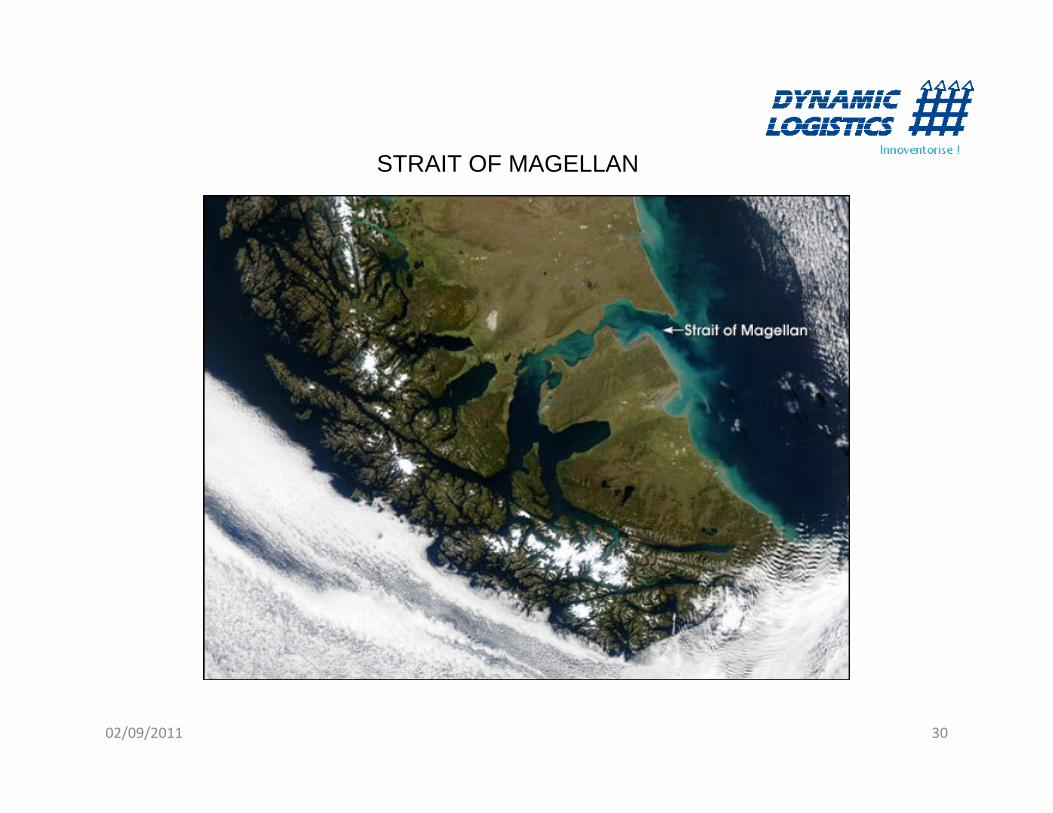
STRAIT OF MAGELLAN

02/09/2011 31
STRAIT OF MAGELLAN

02/09/2011 32
FALKLAND ISLANDS

02/09/2011 33
The Falkland Islands are an overseas territory of the United Kingdom in
the South Atlantic consisting of two main islands known as East Falkland
and West Falkland and a number of smaller islands. The capital Port
Stanley is on East Falkland.
Sovereignty of the islands is also claimed by Argentina where the islands
are known by their name in Spanish, Islas Malvinas. This name comes
from the French, Iles Malouines, so-called from when the islands were
briefly occupied by fishermen from St Malo. The Falkland Islands are
listed by the United Nations Committee on Decolonisation as one of the
16 Non-Self-Governing Territories of the world.
FALKLAND ISLANDS

02/09/2011 34
USHUAIA THE SOUTHERNMOST CITY IN THE WORLD

ROCK OF GIBRALTAR
3502/09/2011

STRAIT OF GIBRALTAR
3602/09/2011

02/09/2011 37
The Strait of Gibraltar is a narrow body of water between Spain and Morocco
that connects the Mediterranean Sea with the Atlantic Ocean. Upwards of 300
cargo vessels pass through the Strait every day. In spite of the heavy
concentration of shipping traffic and the noise caused by it, there is still an
abundance of whales and dolphins in these waters. The Rock is Crown property
of the United Kingdom, and borders Spain. The sovereignty of Gibraltar was
transferred from Spain to the Kingdom of Great Britain by the Treaty of Utrecht
in 1713 after the War of the Spanish Succession.
STRAIT OF GIBRALTAR

02/09/2011 38
ROCK OF GIBRALTAR

02/09/2011 39
STRAITS OF DOVER

02/09/2011 40
STRAITS OF DOVER
02/09/2011 41
The Strait of Dover or Dover Strait is the strait at the narrowest part of the English Channel. The shortest distance across the strait is from the South Foreland, 6 kilometres (some 4 miles) northeast of Dover in the county of Kent, England, to Cap Gris Nez, a cape near to Calais in the French département of Pas-de-Calais, France.
Most maritime traffic between the Atlantic Ocean and the North and Baltic Seas passes through the Strait of Dover, rather than taking the longer and more dangerous route around the north of Scotland. The strait is the busiest international seaway in the world, used by over 400 commercial vessels daily. This has made safety a critical issue, with HM Coastguard maintaining a 24-hour watch over the strait and enforcing a strict regime of shipping lanes.
In addition to the intensive east-west traffic, the strait is criss-crossed from north to south by ferries linking Dover to Calais and Boulogne. Until the 1990s these provided the only ground-based route across it. The Channel Tunnel now provides an alternative route, crossing underneath the strait at an average depth of 45 m (150 feet) underneath the seabed. The town of Dover gives its name to one of the sea areas of the British Shipping Forecast.
STRAITS OF DOVER

02/09/2011 42
VIEW OF THE WHITE CLIFFS OF DOVER FROM FRANCE

02/09/2011 43
THE DANISH STRAITS

02/09/2011 44
THE DANISH STRAITS

02/09/2011 45
The Danish straits are the three channels connecting the Baltic sea to the
North Sea through the Kattegat and Skagerrak. They transect Denmark, and are
not to be confused with the Denmark Strait between Greenland and Iceland.
The three main passages are:
Great Belt, Danish: Storebælt
Little Belt, Danish: Lillebælt
Oresund, Danish: Øresund (Swedish: Öresund)
By closer view there are five straits named Belt (Danish: Bælt), the only ones in
the world, and several straits named Sound (Danish, Swedish, and German:
Sund). Where an Island is situated between a Belt and a Sound, typically the
broader strait is called Belt and the more narrow one is the Sound.
THE DANISH STRAITS

02/09/2011 46
COPENHAGEN

4702/09/2011
BOSPORUS STRAIT

02/09/2011 48
BOSPORUS STRAIT

02/09/2011 49
Straits of Bosporus/Turkish Straits is a 17-mile-long waterway, which connects
the Black Sea with the Mediterranean Sea and supplies Western and Southern
Europe with oil from the Caspian Sea.
The strait is made up of the Bosporus and Dardanelles and divides Asia and
Europe. The Bosporus joins the Black Sea with the Sea of Marmara and the
Dardanelles connects the Sea of Marmara and the Mediterranean Sea. Straits of
Bosporus is the world's narrowest strait used for international navigation.
The Straits are governed under the Montreux Convention, which gives Turkey
control over the Bosporus and the Dardanelles. While Turkish maritime
authorities have the right to levy tolls on the passing tankers and is also
responsible to check ships for sanitary conditions and safety, the Bosporus and
Dardanelles Straits are considered international waterways, and Turkey is
prohibited from restricting their use during peace time.
BOSPORUS STRAIT

02/09/2011 50
ISTANBUL

02/09/2011 51
GREECE

02/09/2011 52
CYPRUS

02/09/2011 53
THE SUEZ CANAL

SUEZ CANAL
5402/09/2011

02/09/2011 55
The Suez Canal is located in Egypt, and connects the Red Sea and Gulf of Suez
with the Mediterranean Sea. The Canal is one of the world’s greatest engineering
feats covering 120 miles.
Oil shipments from the Persian Gulf travel through the Canal primarily to
European ports, but also to the United States. In 2006, an estimated 3.9 million
bbl/d of oil flowed northbound through the Suez Canal to the Mediterranean, while
0.6 million bbl/d travelled southbound into the Red Sea.
Over 3,000 oil tankers pass through the Suez Canal annually, and represent
around 25 percent of the Canal’s total revenues. With only 1,000 feet at its
narrowest point, the Canal is unable to handle large tankers. The Suez Canal
Authority (SCA) has discussed widening and deepening the Canal to
accommodate VLCCs and Ultra Large Crude Carriers (ULCC).
THE SUEZ CANAL

02/09/2011 56
The 200-mile long Sumed Pipeline, or Suez-Mediterranean Pipeline, also
provides a route between the Red and Mediterranean Seas by crossing the
northern region of Egypt from the Ain Sukhna to the Sidi Kerir Terminal. The
pipeline provides an alternative to the Suez Canal, and can transport 3.1
million bbl/d of crude oil. In 2006, nearly all of Saudi Arabia’s northbound
shipments (approximately 2.3 million bbl/d of crude) were transported through
the Sumed pipeline. The pipeline is owned by Arab Petroleum Pipeline Co., a
joint venture between EGPC, Saudi Aramco, AbuDhabi’s ADNOC, and
Kuwaiti companies.
Closure of the Suez Canal and the Sumed Pipeline would divert tankers
around the southern tip of Africa, the Cape of Good Hope, adding 6,000 miles
to transit time.
THE SUEZ CANAL

02/09/2011 57
SUEZ CANAL

02/09/2011 58
CITY OF SUEZ

02/09/2011 59
THE DEAD SEA CANAL

02/09/2011 60
THE DEAD SEA CANAL

02/09/2011 61
THE DEAD SEA CANAL

02/09/2011 62
THE DEAD SEA CANAL

DEAD SEA CANAL
6302/09/2011

02/09/2011 64
The Two Seas Canal (colloquially known as the Dead–Red Canal)
is a proposed canal which would run from the Red Sea to the
Dead Sea and provide electricity and potable water to Jordan,
Israel and the Palestinian Authority. This proposal has a major role
in plans for economic cooperation between Israelis, Jordanians
and Palestinians, through the Peace Valley plan.
THE DEAD SEA CANAL

02/09/2011 65
CAPE OF GOOD HOPE

02/09/2011 66
The Cape of Good Hope is a rocky headland on the Atlantic coast of South Africa.
There is a very common misconception that the Cape of Good Hope is the southern tip of Africa, because it was once believed to be the dividing point between the Atlantic and Indian Oceans. In fact, the southernmost point is Cape Agulhas, about 150 kilometres (90 mi) to the east-southeast. The Atlantic and Indian oceans meet at the point where the warm-water Agulhas current meets the cold-water Benguela current and turns back on itself – a point that fluctuates between Cape Agulhas and Cape Point, about one kilometre east of the Cape of Good Hope.When following the African coastline from the equator, however, the Cape of Good Hope marks the psychologically important point where one begins to travel more eastward than southward. Thus the first rounding of the cape in 1488 by Portuguese explorer Bartolomeu Dias was a major milestone in the attempts by the Portuguese to establish direct trade relations with the Far East. He called the cape Cabo das Tormentas.
CAPE OF GOOD HOPE

02/09/2011 67
CAPE TOWN

02/09/2011 68
BAB – AL - MANDEB

02/09/2011 69
The Strait of Bab el-Mandab is a chokepoint between the horn of Africa and the
Middle East, and a strategic link between the Mediterranean Sea and Indian
Ocean. It is located between Yemen, Djibouti, and Eritrea, and connects the Red
Sea with the Gulf of Aden and the Arabian Sea. Exports from the Persian Gulf
must pass through Bab el-Mandab before entering the Suez Canal. In 2006, an
estimated 3.3 million bbl/d flowed through this waterway toward Europe, the
United States, and Asia. The majority of traffic, around 2.1 million bbl/d, flows
northbound through the Bab el-Mandab to the Suez/Sumed complex.
BAB – AL - MANDEB

02/09/2011 70
ADEN

02/09/2011 71
CITY OF ADEN

STRAIT OF HORMUZ
7202/09/2011

02/09/2011 73
The Strait of Hormuz is a narrow waterway between the Gulf of Oman in the
southeast and the Persian Gulf in the southwest. On the north coast is Iran (Persia)
and on the south is the United Arab Emirates and Musandam, an exclave of Oman.
Description: The narrowest section of the strait is only 21 miles wide, having two
one-milewide channels for marine traffic separated by a two-mile-wide buffer zone.
It is the only sea passage to the open ocean for several petroleum-exporting
Persian Gulf States.
STRAIT OF HORMUZ

02/09/2011 74
Since Oman, Iran, and the United Arab Emirates share the border around
the Straits, all three countries are crucial in fostering a secure environment
there. Oman and the UAE are among the key U.S. allies in the region. The
United States supplies both countries with most of their arms purchases,
including advanced fighter aircraft such as the F-15 and F- 16. In addition,
the United States has maintained a substantial naval carrier task force in the
Persian Gulf area.
STRAIT OF HORMUZ

02/09/2011 75
DUBAI

STRAIT OF MALACCA
7602/09/2011

02/09/2011 77
The Strait of Malacca is a narrow, 805 km (500 mile) stretch of water between
Peninsular Malaysia (West Malaysia) and the Indonesian island of Sumatra. It
is named after the Empire of Melaka that ruled over the archipelago between
1414 to 1511. From an economic and strategic perspective the Strait of
Malacca is one of the most important shipping lanes in the world.
The strait is the main shipping channel between the Indian Ocean and the
Pacific Ocean, linking major Asian economies such as India, China, Japan and
South Korea. Over 50,000 vessels pass through the strait per year, carrying
about one-quarter of the world's traded goods including oil, Chinese
manufactures, and Indonesian coffee.
STRAIT OF MALACCA

02/09/2011 78
About a quarter of all oil carried by sea passes through the strait, mainly from
Persian Gulf suppliers to Asian markets such as China, Japan, and South
Korea. In 2006, an estimated 15 million barrels per day (2,400,000 m3/d) were
transported through the strait. The maximum size of a vessel that can make
passage through the Strait is referred to as Malaccamax.
The strait is not deep enough (at 25 metres or 82 feet) to permit some of the
largest ships (mostly oil tankers) to use it. A ship that exceeds Malaccamax
will typically use the Lombok Strait, Makassar Strait, Sibutu Passage and
Mindoro Strait instead. At Phillips Channel close to the south of Singapore, the
Strait of Malacca narrows to 2.8 km (1.5 nautical miles) wide, creating one of
the world's most significant traffic choke points.
STRAIT OF MALACCA

02/09/2011 79
SINGAPORE CITY

02/09/2011 80
LOMBAK STRAIT

02/09/2011 81
MAKASSAR STRAIT

02/09/2011 82
THE ISTHMUS OF KRA

02/09/2011 83
Proposed Isthmus of Kra Pipeline: A 320 km (193 mile) pipeline is proposed to
be built across the Ishmus of Kra in northern Malaysia from the Kedah state,
across Perak state, to northeastern Kelantan state. The pipeline is expected to
become operational in 2014, transporting about 20% of the oil currently
transiting the strait, and potentially cut three days off the journey from the
Middle East to China, Japan, and South Korea. Several proposals have been
submitted for the pipeline construction, one of which involves the construction
of a coastal refinery. However, in July 2007, Malaysian Prime Minister Abdullah
Ahmad Badawi instead retracted his decision and opted to examine the cost
and environmental impact of the proposed pipeline. Considering the difficulty of
laying pipeline across the northern mountain range and the high cost involved,
the probability of the pipeline project carrying through is debatable.
THE ISTHMUS OF KRA

02/09/2011 84
Thai Government Proposed Canal Via Isthmus of Kra (Thai Canal):
Throughout the course of its history dating back to King Narai the Great, the
Thai government has proposed to build a canal through the Isthmus of Kra.
The canal would shave off 1,200– 1,400 km, or one to three days, versus the
Strait of Malacca route. Compared with the Sunda route, the canal would cut
2,500–3,000 km (four to five days); or 3,000-3,500 km (five to seven days)
instead of Lombok. The Thai Canal is projected to take around five to seven
years to build at a cost of Bt650bn ($22 billion). Although the project has
received strong support from some Thai politicians, it remains somewhat
unlikely to proceed as hoped, given its high price and unfavorable
environmental impact.
THE ISTHMUS OF KRA

02/09/2011 85

02/09/2011 86
THE INDIAN OCEAN RIM

02/09/2011 87
Admiral Timothy J Keating of the US military, Pacific Command (PACOM) has revealed that China offered to divide the Pacific and Indian Ocean regions between China and the US after Beijing launched its own fleet of aircraft carriers.
He added that the incident was disclosed to Indian Navy chief Admiral Sureesh Mehta during their meeting on Thursday May 15, 2009. The proposed “deal”envisaged that after China has its own aircraft carriers — it remains the only major naval power currently without such a capability — the Pacific region could be divided into two areas of responsibility.
“(The Chinese officer said) You, the US, take Hawaii East and we, China, will take Hawai West and the Indian Ocean. Then you will not need to come to the western Pacific and the Indian Ocean and we will not need to go to the Eastern Pacific. If anything happens there, you can let us know and if something happens here, we will let you know,” Keating recalled.
Source: Indian Express Fri May 15 2009
A STARTLING DISCLOSURE

8802/09/2011
APPEARANCES CAN BE VERY DECEPTIVE
THE 90 : 10 RULE

02/09/2011 89
"Whoever controls the Indian Ocean dominates Asia. This ocean
is the key to the seven seas in the twenty-first century, the destiny
of the world will be decided in these waters."
Alfred Thayer Mahan

02/09/2011 90
THE WORLD MAP
Panama
Ushuaia
Cape Town
Copenhagen
Gibraltar
Istanbul
Suez
Dubai
Aden Singapore
Dover
![OWNER’S MANUAL ENGLISH...• Manual choke: Place the choke lever/rod [1] in the CHOKE position when starting a cold engine. Move the choke lever/rod to the OFF position as soon as](https://img.pdfslide.us/doc/110x75/60a7b2c65c7ba02e7841f517/owneras-manual-english-a-manual-choke-place-the-choke-leverrod-1-in.jpg)