Embed Size (px)
Citation preview
STRATEGIC ENVIRONMENTAL NOISE MAPPING & ACTION PLANS IN ATHENS RING ROAD (ATIIKI ODOS) - GREECE
Ass. Prof. KONSTANTINOS VOGIATZIS
Faculty of Civil Engineering, Laboratory of Transportation Environmental Acoustics (L.T.E.A.)
University of Thessaly Pedion Areos - 383 23 Volos
GREECE Email: [email protected]
Abstract: - Attica Tollway, a modern motorway extending along 65 km, constitutes the ring road of the greater metropolitan area of Athens and the backbone of the road network of the whole Attica Prefecture. Attiki Odos during 2008-2010, in close collaboration with the University of Thessaly -Faculty of Civil Engineering (Laboratory of Transportation Environmental Acoustics (L.T.E.A.), has complete a full SNM & NAP (Strategic Noise Maps & Noise Action Plans) study for the road network which resulted in the implementation of an extensive NAP 2010 introducing an important quantity of PMMA transparent noise barriers : some 87.000 sqm of transparent noise barriers in some 138 different locations along the road network. This article presents the main results and conclusion of this research that was completed according to the Directive 2002/49/EC of 25 June 2002 adopted by the European Parliament and Council and the COMMISSION RECOMMENDATION ON AUGUST 6th 2003 (2003/613/EC). A full evaluation of the relevant Strategic Noise Maps & Noise Action Plans is also presented in this article along with comparative analysis of the population exposed to various noises according to the existing legal framework and further the criteria A & B suggested by the Ministry of the Environment for the EU noise indicators Lden & Lnight' Further future action plans which are already under consideration are also presented. Key-Words: Environmental Noise, Environmental monitoring, Road Traffic Noise, Transportation noise
1 Introduction Attica Tollway (Athens Ring Road) is a pioneering project constructed on a concession basis and constitutes one of the biggest co-financed road projects in Europe. It belongs to the first generation of co-financed projects awarded in Greece during the '90s and essentially paved the way and laid the foundations for the execution of future successful concession contracts in Greece and in other European countries [1].
Attica Tollway is a modern motorway extending along 65 km. It constitutes the ring road of the greater metropolitan area of Athens and the backbone of the road network of the whole Attica Prefecture.
It is an urban motorway, with two separate directional carriageways, each consisting of 3 lanes and an emergency lane (hard shoulder).
The suburban railway of Athens has been constructed in the central reservation of the motorway.
Attica Tollway constitutes a unique piece of infrastructure, even in European terms, since it is
essentially a closed toll motorway within a metropolitan capital where the problem of traffic congestion is acute. Attica Tollway is part of the PATHE road axis (Patra - Athens - Thessaloniki - Evzoni) and connects the Athens - Lamia National Road with the Athens - Κorinthοs National Road, by-passing the centre of Athens.
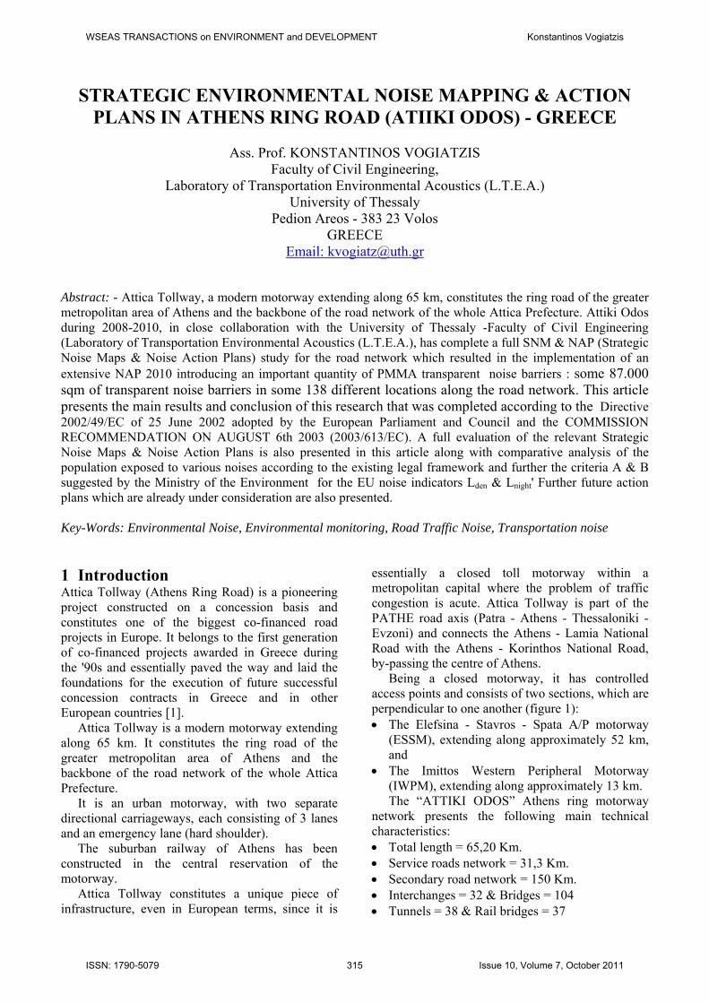
Being a closed motorway, it has controlled access points and consists of two sections, which are perpendicular to one another (figure 1): The Elefsina - Stavros - Spata A/P motorway
(ESSM), extending along approximately 52 km, and
The Imittos Western Peripheral Motorway (IWPM), extending along approximately 13 km. The “ATTIKI ODOS” Athens ring motorway
network presents the following main technical characteristics: Total length = 65,20 Km. Service roads network = 31,3 Km. Secondary road network = 150 Km. Interchanges = 32 & Bridges = 104 Tunnels = 38 & Rail bridges = 37
WSEAS TRANSACTIONS on ENVIRONMENT and DEVELOPMENT Konstantinos Vogiatzis
ISSN: 1790-5079 315 Issue 10, Volume 7, October 2011
Pedestrian over-passes =15 Tunnels & C&C = 63 Tunnel length –C&C = 15,64 Km Services
Services surfaces = 122.000 m2 Environmental Noise & Atm. Pollution
Monitoring Program based on a 24hours mobile monitoring grid according to European directive 2002/49/EC .
Anti Noise barriers (2011) = 87,000 m2
Fig. 1 Attiki Odos motorway (Attica Tollway) The harmonious co-existence of the motorway
with the environment has been a difficult task, but successfully achieved by Attica Tollway regarding environmental noise through the implementation of comprehensive management, including monitoring, assessment & implementation of the appropriate mitigation measures i.e. noise barriers & land use organization.
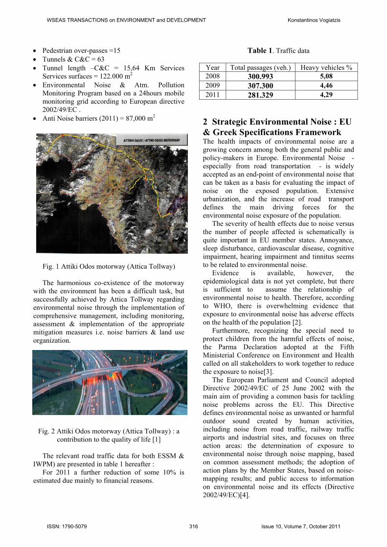
Fig. 2 Attiki Odos motorway (Attica Tollway) : a contribution to the quality of life [1]
The relevant road traffic data for both ESSM &
IWPM) are presented in table 1 hereafter : For 2011 a further reduction of some 10% is
estimated due mainly to financial reasons.
Table 1. Traffic data
Year Total passages (veh.) Heavy vehicles % 2008 300.993 5,08 2009 307.300 4,46 2011 281.329 4,29
2 Strategic Environmental Noise : EU & Greek Specifications Framework The health impacts of environmental noise are a growing concern among both the general public and policy-makers in Europe. Environmental Noise - especially from road transportation - is widely accepted as an end-point of environmental noise that can be taken as a basis for evaluating the impact of noise on the exposed population. Extensive urbanization, and the increase of road transport defines the main driving forces for the environmental noise exposure of the population.
The severity of health effects due to noise versus the number of people affected is schematically is quite important in EU member states. Annoyance, sleep disturbance, cardiovascular disease, cognitive impairment, hearing impairment and tinnitus seems to be related to environmental noise.
Evidence is available, however, the epidemiological data is not yet complete, but there is sufficient to assume the relationship of environmental noise to health. Therefore, according to WHO, there is overwhelming evidence that exposure to environmental noise has adverse effects on the health of the population [2].
Furthermore, recognizing the special need to protect children from the harmful effects of noise, the Parma Declaration adopted at the Fifth Ministerial Conference on Environment and Health called on all stakeholders to work together to reduce the exposure to noise[3].
The European Parliament and Council adopted Directive 2002/49/EC of 25 June 2002 with the main aim of providing a common basis for tackling noise problems across the EU. This Directive defines environmental noise as unwanted or harmful outdoor sound created by human activities, including noise from road traffic, railway traffic airports and industrial sites, and focuses on three action areas: the determination of exposure to environmental noise through noise mapping, based on common assessment methods; the adoption of action plans by the Member States, based on noise-mapping results; and public access to information on environmental noise and its effects (Directive 2002/49/EC)[4].
WSEAS TRANSACTIONS on ENVIRONMENT and DEVELOPMENT Konstantinos Vogiatzis
ISSN: 1790-5079 316 Issue 10, Volume 7, October 2011
To that end the following actions shall be implemented progressively: the determination of exposure to environmental
noise through noise mapping, by methods of assessment common to the Member States;
ensuring that information on environmental noise and its effects is made available to the public;
adoption of action plans by the Member States, based upon noise-mapping results, with a view to preventing and reducing environmental noise where necessary and particularly where exposure levels can induce harmful effects on human health and to preserving environmental noise quality where it is good. This European Directive shall apply to
environmental noise to which humans are exposed in particular in built-up areas, in public parks or other quiet areas in an agglomeration, in quiet areas in open country, near schools, hospitals and other noise sensitive buildings and areas.
Member States shall apply the noise indicators Lden and Lnight that shall be determined by means of the assessment methods. The definition of the Lden level (day-evening-night) is defined by the following formula:
where : Lday is the A-weighted long-term average
sound level as defined in ISO 1996-2: 1987, determined over all the day periods of a year,
Levening is the A-weighted long-term average sound level as defined in ISO 1996-2: 1987, determined over all the evening periods of a year,
Lnight is the A-weighted long-term average sound level as defined in ISO 1996-2: 1987, determined over all the night periods of a year;
According to Article 6 and the Annex II of the Directive 2002/49/EC(ED 2002/49, 2002) the interim computation method for the COMMISSION RECOMMENDATION ON AUGUST 6th 2003 (2003/613/EC) concerning the «Guidelines on the revised interim computation methods for industrial noise, aircraft noise, road traffic noise and railway noise, and related emission data notified under document number C(2003)2807 (Commission Recommendation, 2003) was implemented [5].
Within this research the following technical guidelines & methodologies were adopted: the French methodology «NMPB-Routes-96
(SETRA-CERTU-LCPC-CSTB)», as per the «Arrêté du 5 mai 1995 relatif au bruit des infrastructures routières, Journal Officiel du 10 mai 1995, Article 6» (standard «XPS 31-133») and
the Position Paper (Final Draft) Good Practice for Strategic Noise Mapping and the Production of Associated Data on Noise Exposure, [6]. In Greece, the Joint Ministerial Decision
17252/19.6.1992, Official Journal of Hellenic Republic 395/Β/92 on the “Determination of indicators and maximum permitted noise limits, that come from circulation of on-road and other transportation works”, define the categories of transportation works for which enactment of maximum environmental road transportation noise limit is required while it determines the indicator of traffic noise for the quantitative and qualitative estimation of noise that comes from transportation works.
The maximum noise limits are set as follows: (a) 67 dB(A) for the noise index LeqA (8-20 hours) and (b) 70 dB(A) for the noise index L10 (18 hours). However, special cases such as schools, hospitals, theatres etc., for which special acoustic protection is required, are assessed by introducing limits for the above indices, of 5 or even 10 dB(A) lower.
Even though the Greek environmental law framework applies EU common noise indicators Lden and Lnight, to all environmental noise assessment studies, however, it has not yet defined the relevant corresponding max. permissible limits.
Attiki Odos during 2008-2010, in close collaboration with the University of Thessaly -Faculty of Civil Engineering (Laboratory of Transportation Environmental Acoustics (L.T.E.A.), completed a full SNM & NAP (Strategic Noise Maps & Noise Action Plans) study for the road network.
Specifically for this project, the Greek Ministry of Environment’s preliminary suggestion was the implementation of the following environmental noise criteria: «Criterion Α’» : Lden = 70 dB(A) & Lnight = 60
dB(A) & «Criterion Β’» : Lden = 65 dB(A) & Lnight = 55
dB(A)
10
10
10
5
10 10*810*410*1224
1lg10
nighteveningday LLL
denL
WSEAS TRANSACTIONS on ENVIRONMENT and DEVELOPMENT Konstantinos Vogiatzis
ISSN: 1790-5079 317 Issue 10, Volume 7, October 2011
3 DTM Noise model 2008 : Data Base & Statistical evaluation of Measured vs Predicted values of Lden & Lnight
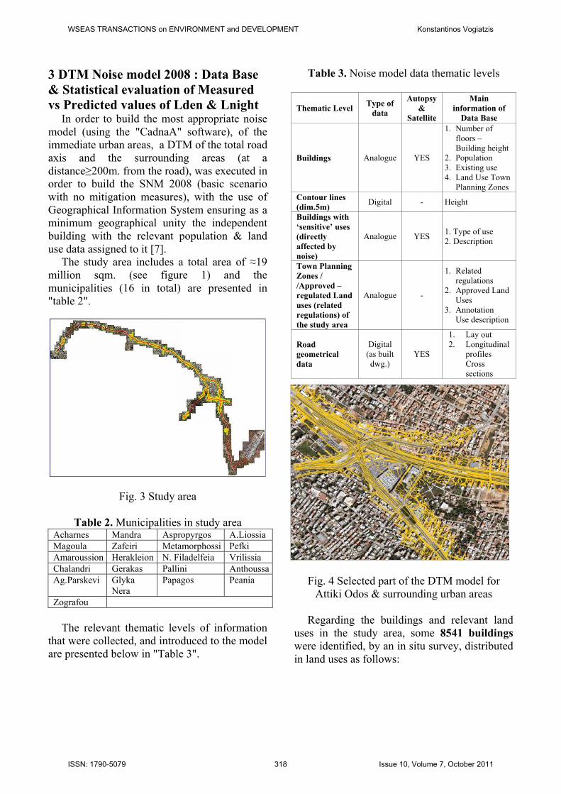
In order to build the most appropriate noise model (using the "CadnaA" software), of the immediate urban areas, a DTM of the total road axis and the surrounding areas (at a distance≥200m. from the road), was executed in order to build the SNM 2008 (basic scenario with no mitigation measures), with the use of Geographical Information System ensuring as a minimum geographical unity the independent building with the relevant population & land use data assigned to it [7].
The study area includes a total area of ≈19 million sqm. (see figure 1) and the municipalities (16 in total) are presented in "table 2".
Fig. 3 Study area
Table 2. Municipalities in study area Acharnes Mandra Aspropyrgos A.Liossia Magoula Zafeiri Metamorphossi Pefki Amaroussion Herakleion N. Filadelfeia Vrilissia Chalandri Gerakas Pallini AnthoussaAg.Parskevi Glyka
Nera Papagos Peania
Zografou The relevant thematic levels of information
that were collected, and introduced to the model are presented below in "Table 3".
Table 3. Noise model data thematic levels
Thematic Level Type of
data
Autopsy &
Satellite
Main information of
Data Base
Buildings Analogue YES
1. Number of floors – Building height
2. Population 3. Existing use 4. Land Use Town
Planning Zones Contour lines (dim.5m)
Digital - Height
Buildings with ‘sensitive’ uses (directly affected by noise)
Analogue YES 1. Type of use 2. Description
Town Planning Zones / /Approved – regulated Land uses (related regulations) of the study area
Analogue -
1. Related regulations
2. Approved Land Uses
3. Annotation Use description
Road geometrical data
Digital (as built dwg.)
YES
1. Lay out 2. Longitudinal
profiles Cross sections
Fig. 4 Selected part of the DTM model for Attiki Odos & surrounding urban areas
Regarding the buildings and relevant land
uses in the study area, some 8541 buildings were identified, by an in situ survey, distributed in land uses as follows:
WSEAS TRANSACTIONS on ENVIRONMENT and DEVELOPMENT Konstantinos Vogiatzis
ISSN: 1790-5079 318 Issue 10, Volume 7, October 2011
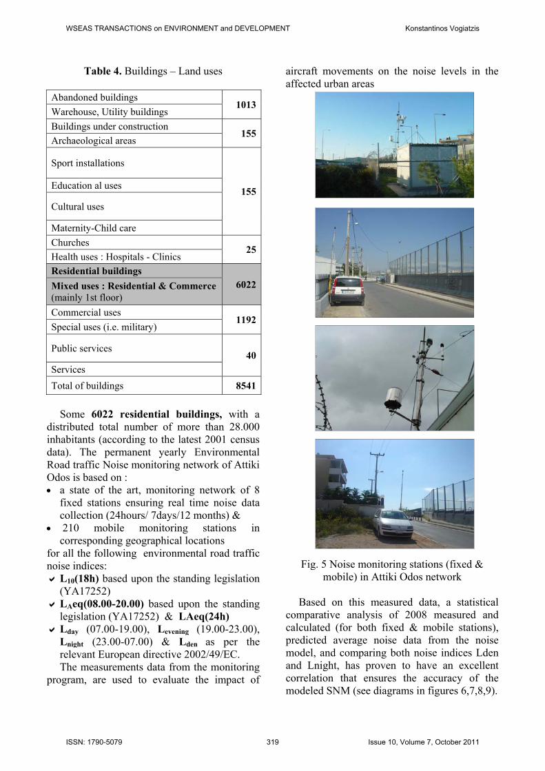
Table 4. Buildings – Land uses
Abandoned buildings 1013
Warehouse, Utility buildings
Buildings under construction 155
Archaeological areas
Sport installations
155Education al uses
Cultural uses
Maternity-Child care
Churches 25
Health uses : Hospitals - Clinics
Residential buildings 6022Mixed uses : Residential & Commerce
(mainly 1st floor)
Commercial uses 1192
Special uses (i.e. military)
Public services 40
Services
Total of buildings 8541
Some 6022 residential buildings, with a
distributed total number of more than 28.000 inhabitants (according to the latest 2001 census data). The permanent yearly Environmental Road traffic Noise monitoring network of Attiki Odos is based on : a state of the art, monitoring network of 8
fixed stations ensuring real time noise data collection (24hours/ 7days/12 months) &
210 mobile monitoring stations in corresponding geographical locations
for all the following environmental road traffic noise indices: L10(18h) based upon the standing legislation
(ΥΑ17252) LΑeq(08.00-20.00) based upon the standing
legislation (ΥΑ17252) & LΑeq(24h) Lday (07.00-19.00), Levening (19.00-23.00),
Lnight (23.00-07.00) & Lden as per the relevant European directive 2002/49/EC. The measurements data from the monitoring
program, are used to evaluate the impact of
aircraft movements on the noise levels in the affected urban areas
Fig. 5 Noise monitoring stations (fixed & mobile) in Attiki Odos network
Based on this measured data, a statistical
comparative analysis of 2008 measured and calculated (for both fixed & mobile stations), predicted average noise data from the noise model, and comparing both noise indices Lden and Lnight, has proven to have an excellent correlation that ensures the accuracy of the modeled SNM (see diagrams in figures 6,7,8,9).
WSEAS TRANSACTIONS on ENVIRONMENT and DEVELOPMENT Konstantinos Vogiatzis
ISSN: 1790-5079 319 Issue 10, Volume 7, October 2011
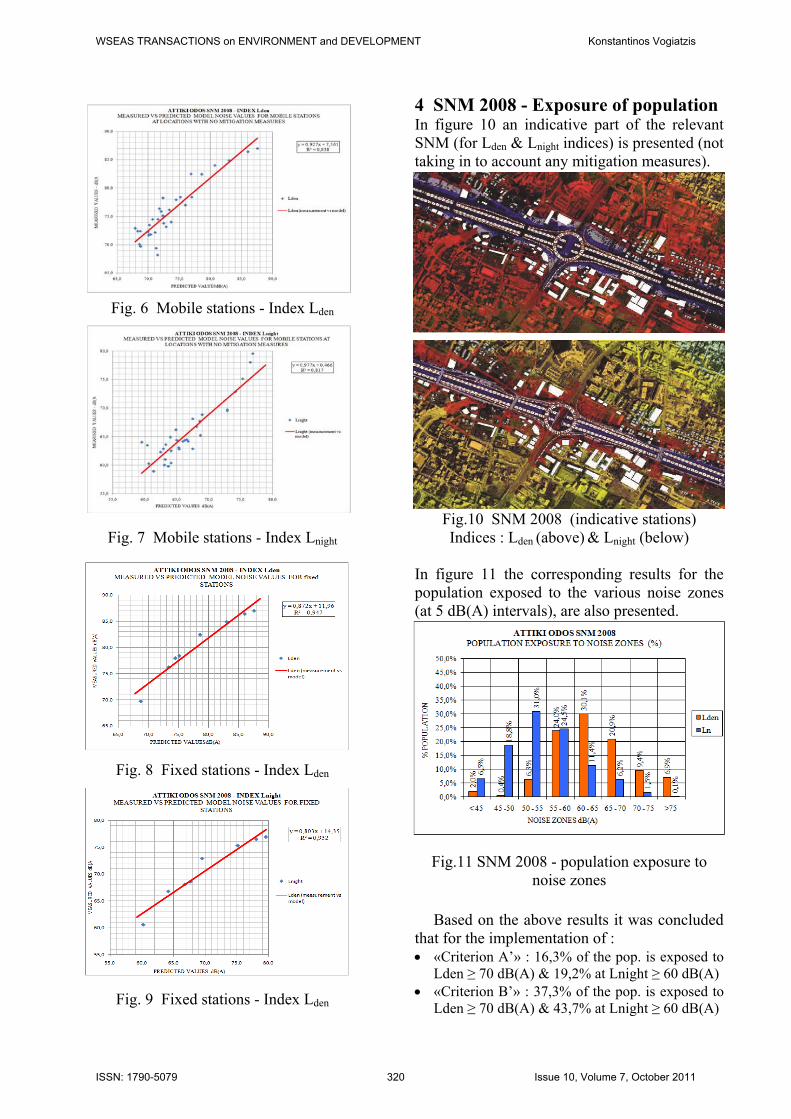
Fig. 6 Mobile stations - Index Lden
Fig. 7 Mobile stations - Index Lnight
Fig. 8 Fixed stations - Index Lden
Fig. 9 Fixed stations - Index Lden
4 SNM 2008 - Exposure of population In figure 10 an indicative part of the relevant SNM (for Lden & Lnight indices) is presented (not taking in to account any mitigation measures).
Fig.10 SNM 2008 (indicative stations) Indices : Lden (above) & Lnight (below)
In figure 11 the corresponding results for the population exposed to the various noise zones (at 5 dB(A) intervals), are also presented.
Fig.11 SNM 2008 - population exposure to
noise zones
Based on the above results it was concluded that for the implementation of : «Criterion Α’» : 16,3% of the pop. is exposed to
Lden ≥ 70 dB(A) & 19,2% at Lnight ≥ 60 dB(A) «Criterion Β’» : 37,3% of the pop. is exposed to
Lden ≥ 70 dB(A) & 43,7% at Lnight ≥ 60 dB(A)
WSEAS TRANSACTIONS on ENVIRONMENT and DEVELOPMENT Konstantinos Vogiatzis
ISSN: 1790-5079 320 Issue 10, Volume 7, October 2011
Based on the relevant population exposure results and the existing legal framework (max allowed limit of the noise index L10(18hr) = 70 dB (A) the implementation of immediate mitigation measures i.e. noise barriers was proven essential introducing the construction of aesthetic noise barriers with effective heights of an acoustically effective height varying from 3,5m, 4,0mm to 4,5m. In this perspective the relevant NAP were developed as per the analysis that follows.
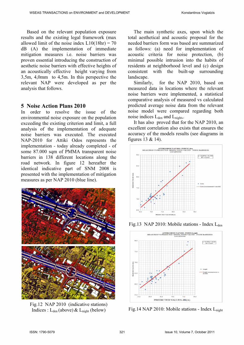
5 Noise Action Plans 2010 In order to resolve the issue of the environmental noise exposure on the population exceeding the existing criterion and limit, a full analysis of the implementation of adequate noise barriers was executed. The executed NAP-2010 for Attiki Odos represents the implementation - today already completed - of some 87.000 sqm of PMMA transparent noise barriers in 138 different locations along the road network. In figure 12 hereafter the identical indicative part of SNM 2008 is presented with the implementation of mitigation measures as per NAP 2010 (blue line).
Fig.12 NAP 2010 (indicative stations) Indices : Lden (above) & Lnight (below)
The main synthetic axes, upon which the total aesthetical and acoustic proposal for the needed barriers form was based are summarized as follows: (a) need for implementation of acoustic criteria for noise protection, (b) minimal possible intrusion into the habits of residents at neighborhood level and (c) design consistent with the built-up surrounding landscape.
Similarly, for the NAP 2010, based on measured data in locations where the relevant noise barriers were implemented, a statistical comparative analysis of measured vs calculated predicted average noise data from the relevant noise model were compared regarding both noise indices Lden and Lnight,.
It has also proved that for the NAP 2010, an excellent correlation also exists that ensures the accuracy of the models results (see diagrams in figures 13 & 14).
Fig.13 NAP 2010: Mobile stations - Index Lden
Fig.14 NAP 2010: Mobile stations - Index Lnight
WSEAS TRANSACTIONS on ENVIRONMENT and DEVELOPMENT Konstantinos Vogiatzis
ISSN: 1790-5079 321 Issue 10, Volume 7, October 2011
In figure 15 the corresponding results for the NAP 2010 regarding the population exposed to the various noise zones (at 5 dB(A) intervals), are also presented.
Fig.15 NAP 2010 - population exposure to
noise zones
Based on the above results it was concluded that for the implementation of : «Criterion Α’» : 7% of the pop. is exposed to
Lden ≥ 70 dB(A) & 9,4% at Lnight ≥ 60 dB(A) «Criterion Β’» : 26% of the pop. is exposed to
Lden ≥ 70 dB(A) & 33,2% at Lnight ≥ 60 dB(A) which indicates a quite important diminution of the population exposed to the respective noise levels as per the SNM 2008.
Further to the above, an additional NAP regarding the protection of the population exposed to environmental noise was assessed regarding 2 major interventions by implementing partial covering of the motorway in the following distinct sections where noise barrier implementation failed to produce adequate results (a) "Avgis street" & (b) "Halandri torrent".
The expected results from these future interventions (currently under study) are presented in the following figures.
In figure 18 a comparative diagram indicates the achieved noise reduction due to NAP 2010 and also due to the future NAP regarding partial covering interventions.
The relevant positive effect in population exposure for both NAP's, and the criteria relating to the EU noise indices Lden & Lnight is therefore established.
Fig. 16 Add. NAP Partial cover at "Avgis street" area : Noise model & noise maps for
Lden & Lnight indices.
WSEAS TRANSACTIONS on ENVIRONMENT and DEVELOPMENT Konstantinos Vogiatzis
ISSN: 1790-5079 322 Issue 10, Volume 7, October 2011
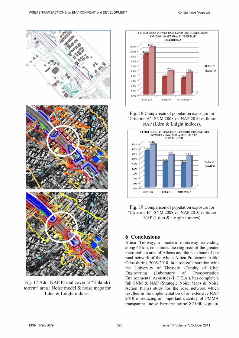
Fig. 17 Add. NAP Partial cover at "Halandri torrent" area : Noise model & noise maps for
Lden & Lnight indices.
Fig. 18 Comparison of population exposure for "Criterion A": SNM 2008 vs NAP 2010 vs future
NAP (Lden & Lnight indices).
Fig. 19 Comparison of population exposure for "Criterion B": SNM 2008 vs NAP 2010 vs future
NAP (Lden & Lnight indices) 6 Conclusions Attica Tollway, a modern motorway extending along 65 km, constitutes the ring road of the greater metropolitan area of Athens and the backbone of the road network of the whole Attica Prefecture. Attiki Odos during 2008-2010, in close collaboration with the University of Thessaly -Faculty of Civil Engineering (Laboratory of Transportation Environmental Acoustics (L.T.E.A.), has complete a full SNM & NAP (Strategic Noise Maps & Noise Action Plans) study for the road network which resulted in the implementation of an extensive NAP 2010 introducing an important quantity of PMMA transparent noise barriers: some 87.000 sqm of
WSEAS TRANSACTIONS on ENVIRONMENT and DEVELOPMENT Konstantinos Vogiatzis
ISSN: 1790-5079 323 Issue 10, Volume 7, October 2011
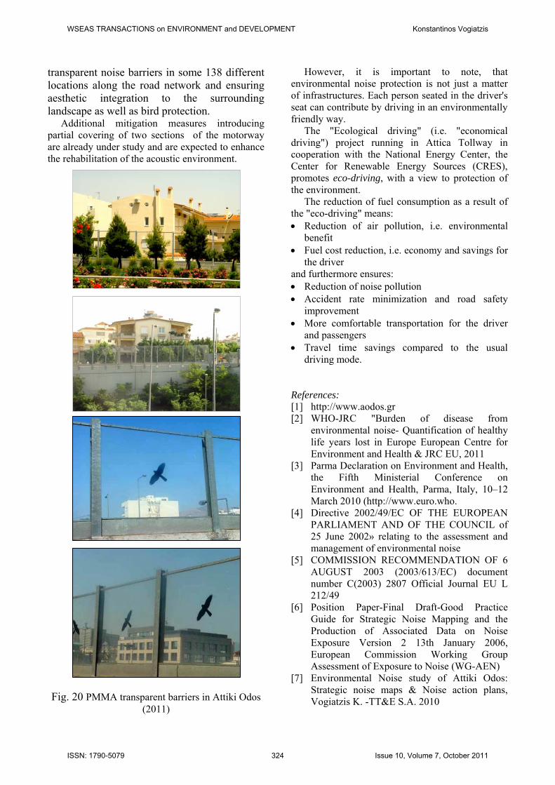
transparent noise barriers in some 138 different locations along the road network and ensuring aesthetic integration to the surrounding landscape as well as bird protection.
Additional mitigation measures introducing partial covering of two sections of the motorway are already under study and are expected to enhance the rehabilitation of the acoustic environment.
Fig. 20 PMMA transparent barriers in Attiki Odos (2011)
However, it is important to note, that environmental noise protection is not just a matter of infrastructures. Each person seated in the driver's seat can contribute by driving in an environmentally friendly way.
The "Ecological driving" (i.e. "economical driving") project running in Attica Tollway in cooperation with the National Energy Center, the Center for Renewable Energy Sources (CRES), promotes eco-driving, with a view to protection of the environment.
The reduction of fuel consumption as a result of the "eco-driving" means: Reduction of air pollution, i.e. environmental
benefit Fuel cost reduction, i.e. economy and savings for
the driver and furthermore ensures: Reduction of noise pollution Accident rate minimization and road safety
improvement More comfortable transportation for the driver
and passengers Travel time savings compared to the usual
driving mode. References: [1] http://www.aodos.gr [2] WHO-JRC "Burden of disease from
environmental noise- Quantification of healthy life years lost in Europe European Centre for Environment and Health & JRC EU, 2011
[3] Parma Declaration on Environment and Health, the Fifth Ministerial Conference on Environment and Health, Parma, Italy, 10–12 March 2010 (http://www.euro.who.
[4] Directive 2002/49/EC OF THE EUROPEAN PARLIAMENT AND OF THE COUNCIL of 25 June 2002» relating to the assessment and management of environmental noise
[5] COMMISSION RECOMMENDATION OF 6 AUGUST 2003 (2003/613/EC) document number C(2003) 2807 Official Journal EU L 212/49
[6] Position Paper-Final Draft-Good Practice Guide for Strategic Noise Mapping and the Production of Associated Data on Noise Exposure Version 2 13th January 2006, European Commission Working Group Assessment of Exposure to Noise (WG-AEN)
[7] Environmental Noise study of Attiki Odos: Strategic noise maps & Noise action plans, Vogiatzis K. -TT&E S.A. 2010
WSEAS TRANSACTIONS on ENVIRONMENT and DEVELOPMENT Konstantinos Vogiatzis
ISSN: 1790-5079 324 Issue 10, Volume 7, October 2011


![Design of Low-phase Noise, Low-power Ring Oscillator for ...€¦ · in data communication that requires low-phase noise performance [1,2]. In an optical communication network as](https://img.pdfslide.us/doc/110x75/5ea04df8b410ef18a7447d7c/design-of-low-phase-noise-low-power-ring-oscillator-for-in-data-communication.jpg)