Embed Size (px)
Citation preview

Empangeni Divisional Meeting of
the ZCCI – 22 September 2016
Presented by Andrew Schultz
Strategic Corridor Plan for the
uMhlathuze-Ulundi-Vryheid
Secondary Corridor
The Spirit of the Emakhosini is a monument to the Zulu people. It comprises, a bronze Zulu beer -pot, surrounded by the horns/tusks of seven animals associated with the Zulu. The pot stands on a beaded plinth accompanied by bronze reliefs of scenes of traditional Zulu life. The beer-pot is an item found in every household and is symbolic both as a receptacle of the heritage of the valley, and of a spirit of togetherness. The horns symbolise the seven Zulu kings who are buried in the valley.

2
CONTENTS OF PRESENTATION A. INTRODUCTION
B. SITUATIONAL ANALYSIS & HIGH LEVEL STRATEGIC ASSESSMENT
1. POLICY CONTEXT AND VISION DIRECTIVES
2. SPATIAL CHALLENGES AND OPPORTUNITIES
3. SYNTHESIS
C. SC1 REGIONAL SDF
1. VISION STATEMENT
2. SPATIAL CONCEPT
3. “PROTECT”, “CHANGE” AND “NEW” STRATEGIES
D. WAY FORWARD
A. INTRODUCTION (1 OF 3) 1. AIM & OBJECTIVES
3
The ‘SC1’ Regional SDF will establish a 25 year strategic framework
The aim is to coordinate public sector resources to support the vision and create a framework for private investment that promotes economic growth and social well-being in an environmentally sustainable manner.
The key objectives of the ‘SC1’ Regional SDF are to:
Support value chain and logistics
Encourage investment growth and development
Coordinate infrastructure development
Guide land use and spatial planning.

A. INTRODUCTION (2 OF 3) 3. STUDY AREA AT COMMENCEMENT OF SITUATIONAL ANALYSIS
4
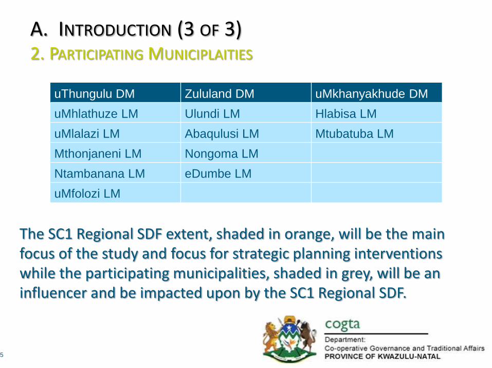
A. INTRODUCTION (3 OF 3) 2. PARTICIPATING MUNICIPLAITIES
5
uThungulu DM Zululand DM uMkhanyakhude DM
uMhlathuze LM Ulundi LM Hlabisa LM
uMlalazi LM Abaqulusi LM Mtubatuba LM
Mthonjaneni LM Nongoma LM
Ntambanana LM eDumbe LM
uMfolozi LM
The SC1 Regional SDF extent, shaded in orange, will be the main focus of the study and focus for strategic planning interventions while the participating municipalities, shaded in grey, will be an influencer and be impacted upon by the SC1 Regional SDF.

6
CONTENTS OF PRESENTATION A. INTRODUCTION
B. SITUATIONAL ANALYSIS & HIGH LEVEL STRATEGIC ASSESSMENT
1. POLICY CONTEXT AND VISION DIRECTIVES
2. SPATIAL CHALLENGES AND OPPORTUNITIES
3. SYNTHESIS
C. SC1 REGIONAL SDF
1. VISION STATEMENT
2. SPATIAL CONCEPT
3. “PROTECT”, “CHANGE” AND “NEW” STRATEGIES
D. WAY FORWARD

1. POLICY CONTEXT & VISION DIRECTIVES (1 OF 12) APPROACH
7
Policy Context and Vision Directives
Theme based –
Biophysical
Socio-Economic
& Built Environment
Scale for Legislative and Policy Framework –
International
National
Provincial
& Municipal

1. POLICY CONTEXT & VISION DIRECTIVES (2 OF 12) PROCESS
8
Built Environment
Analysis Transport
Spatial Planning
Infrastructure
Biophysical Analysis
Socio-Economic Analysis
Key Policy Directives

9
SPLUMA/NDP/NSDP/IUDF
KZN PSEDS/PGDS/PGDP/PSDF
Regional SDFs
District GDPs, IDPs and SDFs
Local IDPs and SDFs
Local Area Plans and Precinct Plans
Land Use Schemes
UUV SC1 Regional
SDF
DRDLR Spatial Development Framework Guidelines
KZN Provincial Human
Settlements Master Spatial
Plan
SIP2 and N2 Strategic
Corridor Plan District and Local
Biodiversity Plans, LED Strategies,
Transport Plans, etc.
PRASA and Intersite Plans, Transnet Plans,
DoT Plans, SANRAL Plans,
etc.
1. POLICY CONTEXT & VISION DIRECTIVES (3 OF 12)

1. POLICY CONTEXT & VISION DIRECTIVES (4 OF 12)
10
Development Corridors:
Ermelo-Richards Bay Freight Corridor
Ermelo - Swaziland
Gauteng - Zimbabwe
Gauteng - Botswana
Mozambique - uMkhanyakhude
NDP Schema

1. POLICY CONTEXT & VISION DIRECTIVES (5 OF 12)
11

1. POLICY CONTEXT & VISION DIRECTIVES (6 OF 12)
12
REGIONAL INDUSTRIAL DEVELOPMENT
STRATEGY

1. POLICY CONTEXT & VISION DIRECTIVES (7 OF 12) MPUMALANGA SDF
13
Ermelo N2
Bethal – N17
Standerton R23
Balfour
Volksrust
Piet Retief

1. POLICY CONTEXT & VISION DIRECTIVES (8 OF 12) MPUMALANGA SDF
14
Ermelo N2
Bethal – N17
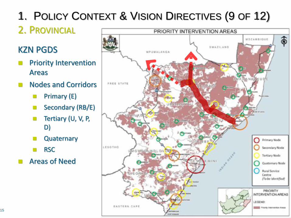
1. POLICY CONTEXT & VISION DIRECTIVES (9 OF 12) 2. PROVINCIAL
15
KZN PGDS
Priority Intervention Areas
Nodes and Corridors
Primary (E)
Secondary (RB/E)
Tertiary (U, V, P, D)
Quaternary
RSC
Areas of Need
Classificatio
n PSEDS/PGDS Definition
Nodes within
Study Area
Nodes outside
Study Area
Primary
Node
An urban centre with very high
existing economic growth and the
potential for expansion thereof.
Provides service to the national and
provincial economy.
eThekwini
Secondary
Node
An urban centre with good existing
economic development and the
potential for growth and services to
the regional economy.
Richards Bay/
Empangeni
Newcastle
Msunduzi
Port Shepstone
Tertiary
Node
A centre which should provide
service to the sub-regional
economy and community needs.
Ulundi
Vryheid
Dundee
Ladysmith
Estcourt
Howick
Stanger, etc.
Quaternary
Node
A centre which should provide
service to the local economy and
community needs.
Ntambanana
KwaMbonambi
Mtubatuba
Melmoth
Hlabisa
Nongoma
Eshowe
Paulpietersburg
Nqutu
Nkandla
Hluhluwe
Mkhuze
Utrecht, etc.
Rural Service
Centre
A centre that serves as the lowest
level of provincial nodes and could
typically be established around
existing traditional administration
centres as well as other accessible
rural points identified as periodic
markets.
To be identified
in consultation
with District
Municipalities
To be identified
in consultation
with District
Municipalities
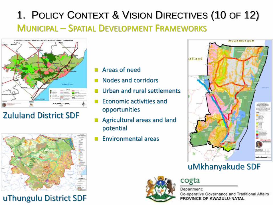
1. POLICY CONTEXT & VISION DIRECTIVES (10 OF 12) MUNICIPAL – SPATIAL DEVELOPMENT FRAMEWORKS
16
Zululand District SDF
uMkhanyakude SDF
uThungulu District SDF
Areas of need
Nodes and corridors
Urban and rural settlements
Economic activities and opportunities
Agricultural areas and land potential
Environmental areas

1. POLICY CONTEXT & VISION DIRECTIVES (11 OF 12) R34
17
P700
R34 - Realignment R34
R66

POLICY CONTEXT & VISION DIRECTIVES ( 12 OF 12) ADJUSTED STUDY AREA
18

19
CONTENTS OF PRESENTATION A. INTRODUCTION
B. SITUATIONAL ANALYSIS & HIGH LEVEL STRATEGIC ASSESSMENT
1. POLICY CONTEXT AND VISION DIRECTIVES
2. SPATIAL CHALLENGES AND OPPORTUNITIES
3. SYNTHESIS
C. SC1 REGIONAL SDF
1. VISION STATEMENT
2. SPATIAL CONCEPT
3. “PROTECT”, “CHANGE” AND “NEW” STRATEGIES
D. WAY FORWARD
20
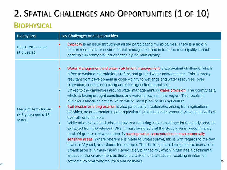
2. SPATIAL CHALLENGES AND OPPORTUNITIES (1 OF 10) BIOPHYSICAL
Biophysical Key Challenges and Opportunities
Short Term Issues
(≤ 5 years)
Capacity is an issue throughout all the participating municipalities. There is a lack in
human resources for environmental management and in turn, the municipality cannot
address environmental issues faced by the municipality.
Medium Term Issues
(> 5 years and ≤ 15
years)
Water Management and water catchment management is a prevalent challenge, which
refers to wetland degradation, surface and ground water contamination. This is mostly
resultant from development in close vicinity to wetlands and water resources, over
cultivation, communal grazing and poor agricultural practices.
Linked to the challenges around water management, is water provision. The country as a
whole is facing drought conditions and water is scarce in the region. This results in
numerous knock-on effects which will be most prominent in agriculture.
Soil erosion and degradation is also particularly problematic, arising from agricultural
activities, no crop rotations, poor agricultural practices and communal grazing, as well as
over utilization of soils.
While urbanisation and urban sprawl is a recurring major challenge for the study area, as
extracted from the relevant IDPs, it must be noted that the study area is predominantly
rural. Of greater relevance then, is rural sprawl or concentration in environmentally
sensitive areas. Where reference is made to urban sprawl, this is with regards to the few
towns in Vryheid, and Ulundi, for example. The challenge here being that the increase in
urbanisation is in many cases inadequately planned for, which in turn has a detrimental
impact on the environment as there is a lack of land allocation, resulting in informal
settlements near watercourses and wetlands.

2. POLICY CONTEXT & VISION DIRECTIVES ( 2 OF 10) AGRICULTURAL LAND COVER
21

2. POLICY CONTEXT & VISION DIRECTIVES ( 3 OF 10) EZEMVELO KZN WILDLIFE CORRIDORS
22
iSimangaliso
Wetland Park
W.H.S
Ithala
Um./Hl.
Ophathe
Ngoye Forest Reserve

2. POLICY CONTEXT & VISION DIRECTIVES ( 4 OF 10) KEY SENSITIVITY AREAS
23

2. POLICY CONTEXT & VISION DIRECTIVES ( 5 OF 10) TREAT WITH CAUTION AREAS
24

25
2. SPATIAL CHALLENGES AND OPPORTUNITIES (6 OF 10) SOCIO-ECONOMIC Socio-Economic Short Term Opportunities Short Term Challenges
Short Term Issues
(≤ 5 years)
P700 Road Linkage
construction/upgrade
Agro-Processing incorporating Bio-
Fuels
Industrial Regeneration
Small Town Regeneration
Hydo-Electricity (Jozini)
Climate change and prolonged periods
of drought
Lack of adequate water supply
High levels of crime and risk
Poor supply of electricity in the District
Medium Term Issues
(> 5 years and ≤ 15
years)
Airport Development (Ulundi)
Eco, Battlefields and Cultural
Heritage Tourism Routes
Makatini Flats Agriculture
Industrial Development Zone (IDZ)
Rural Waste Management Units
Infrastructure degradation and
dilapidated state of roads
Low Levels of skills development and
literacy
Poor spatial planning footprints showing
two separate developments
Lack of coordination and working
together of municipalities.

26
2. SPATIAL CHALLENGES AND OPPORTUNITIES (7 OF 10) BUILT – SPATIAL PLANNING
Planning Key Challenges and Opportunities
Challenges
Uncoordinated spatial development
Spatial fragmentation
Spatial structure and economic inequality
Programmatic service delivery approach and costs
Rapid and unmanaged urbanisation
Low densities and settlement sprawl
Weakly defined settlement hierarchy
Shortage of social and utility services
Integrated land use management challenges
Significant environmental resources
Constrained transport network
Limited infrastructure network capacity
Opportunities
Improved co-ordination and alignment, including SC1 Regional SDF
Human settlement programmes and investments and potential to
strengthen human settlement development
Rail and road infrastructure improvements, including P700
Improved connectivity and access to tourism facilities, urban services,
agricultural distribution, etc.
Proposed Vryheid Airport and industrial development
Local agricultural production and small scale farmer opportunities
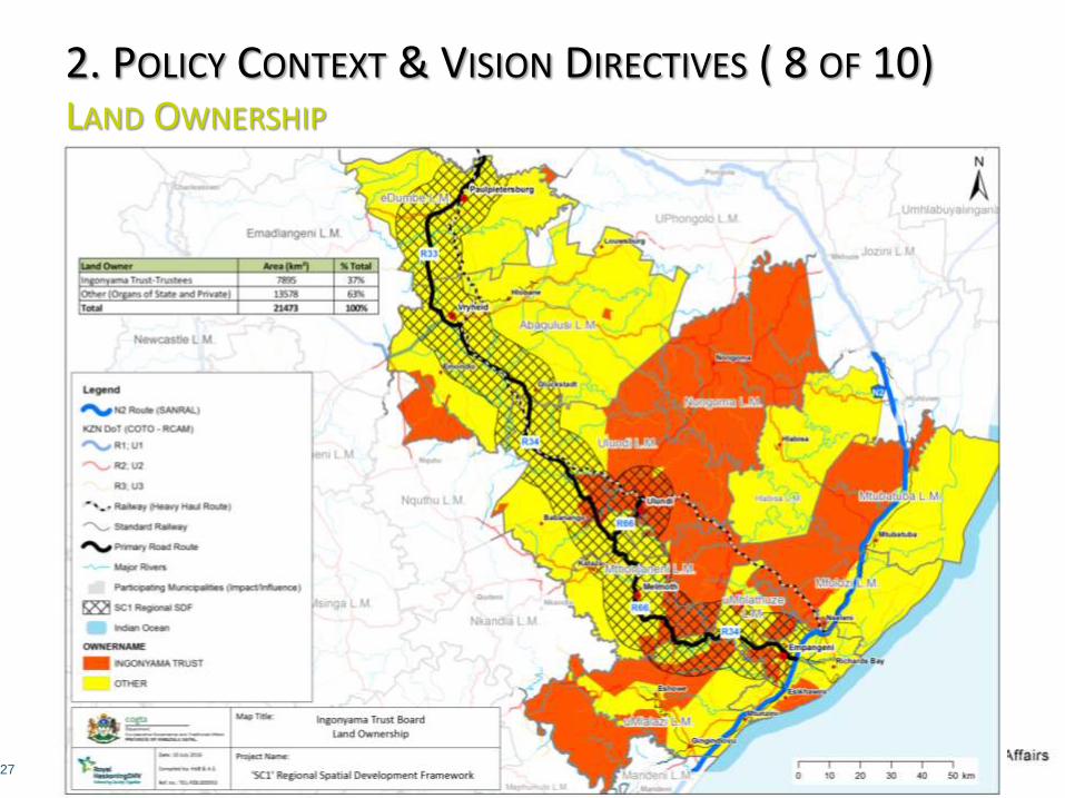
2. POLICY CONTEXT & VISION DIRECTIVES ( 8 OF 10) LAND OWNERSHIP
27
28
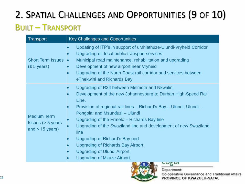
2. SPATIAL CHALLENGES AND OPPORTUNITIES (9 OF 10) BUILT – TRANSPORT
Transport Key Challenges and Opportunities
Short Term Issues
(≤ 5 years)
Updating of ITP’s in support of uMhlathuze-Ulundi-Vryheid Corridor
Upgrading of local public transport services
Municipal road maintenance, rehabilitation and upgrading
Development of new airport near Vryheid
Upgrading of the North Coast rail corridor and services between
eThekwini and Richards Bay
Medium Term
Issues (> 5 years
and ≤ 15 years)
Upgrading of R34 between Melmoth and Nkwalini
Development of the new Johannesburg to Durban High-Speed Rail
Line,
Provision of regional rail lines – Richard’s Bay – Ulundi; Ulundi –
Pongola; and Msunduzi – Ulundi
Upgrading of the Ermelo – Richards Bay line
Upgrading of the Swaziland line and development of new Swaziland
line
Upgrading of Richard’s Bay port
Upgrading of Richards Bay Airport:
Upgrading of Ulundi Airport:
Upgrading of Mkuze Airport
29
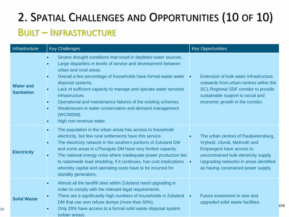
2. SPATIAL CHALLENGES AND OPPORTUNITIES (10 OF 10) BUILT – INFRASTRUCTURE
Infrastructure Key Challenges Key Opportunities
Water and
Sanitation
Severe drought conditions that result in depleted water sources.
Large disparities in levels of service and development between
urban and rural areas.
Overall a few percentage of households have formal waste water
disposal systems.
Lack of sufficient capacity to manage and operate water services
infrastructure.
Operational and maintenance failures of the existing schemes.
Weaknesses in water conservation and demand management
(WC/WDM).
High non-revenue water.
Extension of bulk water infrastructure
outwards from urban centres within the
SC1 Regional SDF corridor to provide
sustainable support to social and
economic growth in the corridor.
Electricity
The population in the urban areas has access to household
electricity, but few rural settlements have this service.
The electricity network in the southern portions of Zululand DM
and some areas in uThungulu DM have very limited capacity.
The national energy crisis where inadequate power production led
to nationwide load shedding, if it continues, has cost implications
whereby capital and operating costs have to be incurred for
standby generators.
The urban centres of Paulpietersburg,
Vryheid, Ulundi, Melmoth and
Empangeni have access to
unconstrained bulk electricity supply.
Upgrading networks in areas identified
as having constrained power supply.
Solid Waste
Almost all the landfill sites within Zululand need upgrading in
order to comply with the relevant legal requirements.
There are a significantly high numbers of households in Zululand
DM that use own refuse dumps (more than 50%).
Only 20% have access to a formal solid waste disposal system
(urban areas).
Future investment in new and
upgraded solid waste facilities.

30
CONTENTS OF PRESENTATION A. INTRODUCTION
B. SITUATIONAL ANALYSIS & HIGH LEVEL STRATEGIC ASSESSMENT
1. POLICY CONTEXT AND VISION DIRECTIVES
2. SPATIAL CHALLENGES AND OPPORTUNITIES
3. SYNTHESIS
C. SC1 REGIONAL SDF
1. VISION STATEMENT
2. SPATIAL CONCEPT
3. “PROTECT”, “CHANGE” AND “NEW” STRATEGIES
D. WAY FORWARD

3. SYNTHESIS (1 OF 4) SPATIAL CONCEPTS
31
Develop Accessibility Framework
Define and Strengthen Settlement Hierarchy
Reinforce and Develop Activity Nodes and Corridors
Address Housing and Social Needs and Develop Integrated Human Settlements
Contain Urban and Rural Sprawl
Promote Quality Settlement Design
Protect Tourism, Agricultural, Heritage and Natural Assets
Develop Local Economic Opportunities

3. SYNTHESIS (2 OF 4) CAPITAL INVESTMENT FRAMEWORK – DEVELOPMENT NODES
32
Hierarchy Definition Relationship to other classifications Nodes Identified
Metro Node
Significant urban centre with high
existing economic growth and the
potential for expansion thereof.
Provides services to the provincial
and regional economy and community
needs.
Second order nodes in KZN
PSEDS/PGDS.
Proposed metro node in uThungulu
SDF.
Richards Bay/ Empangeni
Primary Node
Urban centre with good economic
development and the potential for
growth.
Provides services to the sub-regional
and district economy and community
needs.
Third order nodes in KZN
PSEDS/PGDS.
First order nodes in district SDFs.
Vryheid
Ulundi
Mtubatuba
Secondary Node
Centre with important service delivery
and commercial functions within the
district and local economies of their
respective municipalities.
Fourth order nodes in KZN
PSEDS/PGDS.
Second order nodes in district SDFs
or first order nodes in local SDFs.
Eshowe
Melmoth
Ntambanana
Heatonville
KwaMbonambi
Nongoma
Paulpietersburg/ eDumbe
Hlabisa
Tertiary Node
Centre that provides basic
government service delivery to the
surrounding communities with limited
commercial activities and little to no
services sector.
Not specifically identified in KZN
PSEDS/PGDS.
Third order nodes in district SDFs
and/or secondary nodes in local
SDFs.
Identified in district and local SDFs.
Quaternary Nodes
Small rural centres that provide lower
order services to surrounding rural
settlements.
Not specifically identified in KZN
PSEDS/PGDS or district SDFs.
Third order nodes in local SDFs.
Identified in local SDFs.

3. SYNTHESIS (3 OF 4) SPATIAL CONCEPT DIAGRAM
33

3. SYNTHESIS (4 OF 4) PILLARS OF THE VISION AND DRAFT VISION STATEMENT
34
To develop a sustainable regional corridor that reflects the people, heritage and landscape connected by the corridor and which supports an economically viable and diverse region and an improved quality of life for local communities through economic growth, job creation, urban and rural development, improved service delivery and the protection of the environment.
Diverse and Growing Economy
Equitable Access to Services,
Facilities and Amenities
Sustainable Natural
Environment
Liveable Built
Environment

35
CONTENTS OF PRESENTATION A. INTRODUCTION
B. SITUATIONAL ANALYSIS & HIGH LEVEL STRATEGIC ASSESSMENT
1. POLICY CONTEXT AND VISION DIRECTIVES
2. SPATIAL CHALLENGES AND OPPORTUNITIES
3. SYNTHESIS
C. SC1 REGIONAL SDF
1. VISION STATEMENT
2. SPATIAL CONCEPT
3. “PROTECT”, “CHANGE” AND “NEW” STRATEGIES
D. WAY FORWARD

3. SC1 REGIONAL SDF (1 OF 7) VISION STATEMENT
36
Incorporating -
Feasible alternative access to Port from Gauteng with road improvements
Tourism: iSimangaliso Wetland Park (W.H.S.), Hluhluwe–Imfolozi Park, The eMakhosini - Ophathe Heritage Park and Ithala Game Reserve
Cultural Heritage: Zulu, Afrikaner and German, and Anglo-Zulu and Anglo-Boer War
National Strategic Water Resources, Pongola, Mfolozi, Mhlathuze Headwaters and Coastal Wetlands
Agriculture incl. Forestry

3. SC1 REGIONAL SDF (2 OF 7) SPATIAL CONCEPT
37
Legend
Key
Nodes

3. SC1 REGIONAL SDF (3 OF 7) “PROTECT”, “CHANGE” AND “NEW” STRATEGIES: ENVIRONMENT
38

3. SC1 REGIONAL SDF (4 OF 7) “PROTECT”, “CHANGE” AND “NEW” STRATEGIES: SOCIO-ECON.
39

3. SC1 REGIONAL SDF (5 OF 7) “PROTECT”, “CHANGE” AND “NEW” STRATEGIES: PLANNING
40

3. SC1 REGIONAL SDF (6 OF 7) “PROTECT”, “CHANGE” AND “NEW” STRATEGIES: TRANSPORT
41

3. SC1 REGIONAL SDF (7 OF 7) “PROTECT”, “CHANGE” AND “NEW” STRATEGIES: INFRASTRUCTURE
42

43
CONTENTS OF PRESENTATION A. INTRODUCTION
B. SITUATIONAL ANALYSIS & HIGH LEVEL STRATEGIC ASSESSMENT
1. POLICY CONTEXT AND VISION DIRECTIVES
2. SPATIAL CHALLENGES AND OPPORTUNITIES
3. SYNTHESIS
C. SC1 REGIONAL SDF
1. VISION STATEMENT
2. SPATIAL CONCEPT
3. “PROTECT”, “CHANGE” AND “NEW” STRATEGIES
D. WAY FORWARD

C. WAY FORWARD 1. KEY MILESTONE DATES (1 OF 2)
44
Deliverable 1: Inception
Report
21 April 2016
Deliverable 2: Situational Analysis & High Level Strategic Assessment
15 July 2016
Deliverable 3: Strategic Corridor Development
Plan
1 November 2016
Deliverable 4: Focus Area Plans
11 May 2016
Deliverable 5: Implementation Plan
28 June 2016
Deliverable 6: Close Out Report
24 July 2016
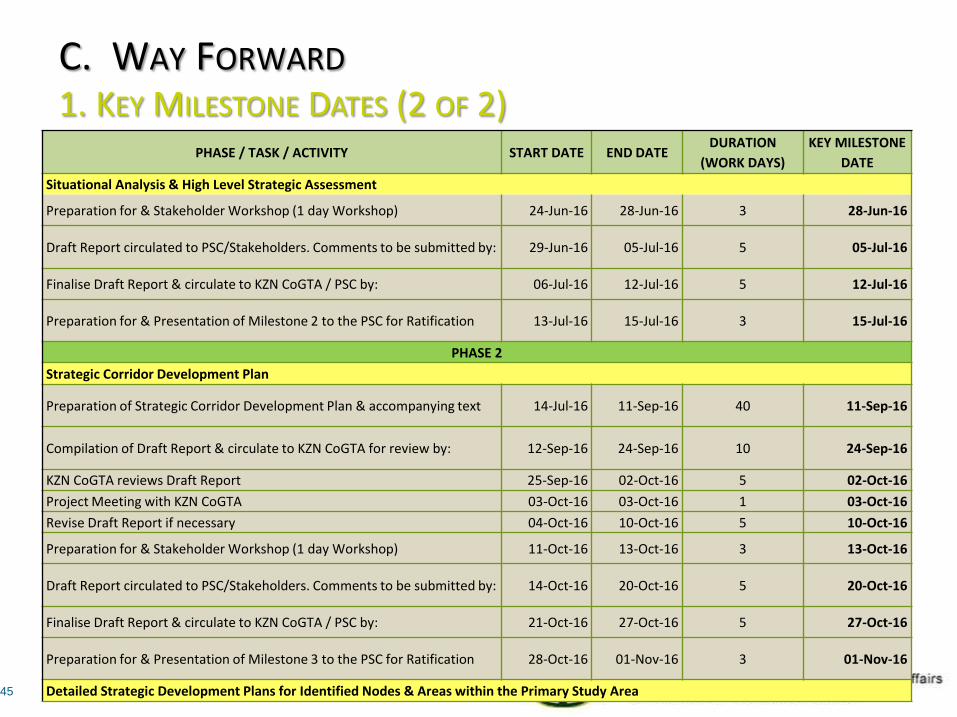
C. WAY FORWARD 1. KEY MILESTONE DATES (2 OF 2)
45
PHASE / TASK / ACTIVITY START DATE END DATE
DURATION
(WORK DAYS)
KEY MILESTONE
DATE
Situational Analysis & High Level Strategic Assessment
Preparation for & Stakeholder Workshop (1 day Workshop) 24-Jun-16 28-Jun-16 3 28-Jun-16
Draft Report circulated to PSC/Stakeholders. Comments to be submitted by: 29-Jun-16 05-Jul-16 5 05-Jul-16
Finalise Draft Report & circulate to KZN CoGTA / PSC by: 06-Jul-16 12-Jul-16 5 12-Jul-16
Preparation for & Presentation of Milestone 2 to the PSC for Ratification 13-Jul-16 15-Jul-16 3 15-Jul-16
PHASE 2
Strategic Corridor Development Plan
Preparation of Strategic Corridor Development Plan & accompanying text 14-Jul-16 11-Sep-16 40 11-Sep-16
Compilation of Draft Report & circulate to KZN CoGTA for review by: 12-Sep-16 24-Sep-16 10 24-Sep-16
KZN CoGTA reviews Draft Report 25-Sep-16 02-Oct-16 5 02-Oct-16
Project Meeting with KZN CoGTA 03-Oct-16 03-Oct-16 1 03-Oct-16
Revise Draft Report if necessary 04-Oct-16 10-Oct-16 5 10-Oct-16
Preparation for & Stakeholder Workshop (1 day Workshop) 11-Oct-16 13-Oct-16 3 13-Oct-16
Draft Report circulated to PSC/Stakeholders. Comments to be submitted by: 14-Oct-16 20-Oct-16 5 20-Oct-16
Finalise Draft Report & circulate to KZN CoGTA / PSC by: 21-Oct-16 27-Oct-16 5 27-Oct-16
Preparation for & Presentation of Milestone 3 to the PSC for Ratification 28-Oct-16 01-Nov-16 3 01-Nov-16
Detailed Strategic Development Plans for Identified Nodes & Areas within the Primary Study Area