Embed Size (px)
Citation preview
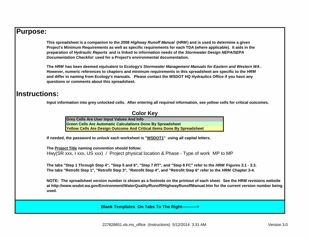
Purpose:
Instructions:
Grey Cells Are User Input Values And Info
Green Cells Are Automatic Calculations Done By Spreadsheet Yellow Cells Are Design Outcome And Critical Items Done By Spreadsheet
The Project Title naming convention should follow:
NOTE: The spreadsheet version number is shown as a footnote on the printout of each sheet. See the HRM revisions website
at http://www.wsdot.wa.gov/Environment/WaterQuality/Runoff/HighwayRunoffManual.htm for the current version number being
used.
Blank Templates On Tabs To The Right---------->
Hwy(SR xxx, I xxx, US xxx) / Project physical location & Phase - Type of work MP to MP
This spreadsheet is a companion to the 2008 Highway Runoff Manual (HRM ) and is used to determine a given
Project's Minimum Requirements as well as specific requirements for each TDA (where applicable). It aids in the
preparation of Hydraulic Reports and is linked to information needs of the Stormwater Design NEPA/SEPA
Documentation Checklist used for a Project's environmental documentation.
Color Key
The tabs "Step 1 Through Step 4", "Step 5 and 6", "Step 7 RT", and "Step 8 FC" refer to the HRM Figures 3.1 - 3.3.
The tabs "Retrofit Step 1", "Retrofit Step 3", "Retrofit Step 4", and "Retrofit Step 6" refer to the HRM Chapter 3-4.
If needed, the password to unlock each worksheet is "WSDOT1" using all capital letters.
Input information into grey unlocked cells. After entering all required information, see yellow cells for critical outcomes.
The HRM has been deemed equivalent to Ecology's Stormwater Management Manuals for Eastern and Western WA .
However, numeric references to chapters and minimum requirements in this spreadsheet are specific to the HRM
and differ in naming from Ecology's manuals. Please contact the WSDOT HQ Hydraulics Office if you have any
questions or comments about this spreadsheet.
227828651.xls.ms_office (Instructions) 5/12/2014 3:31 AM Version 3.0
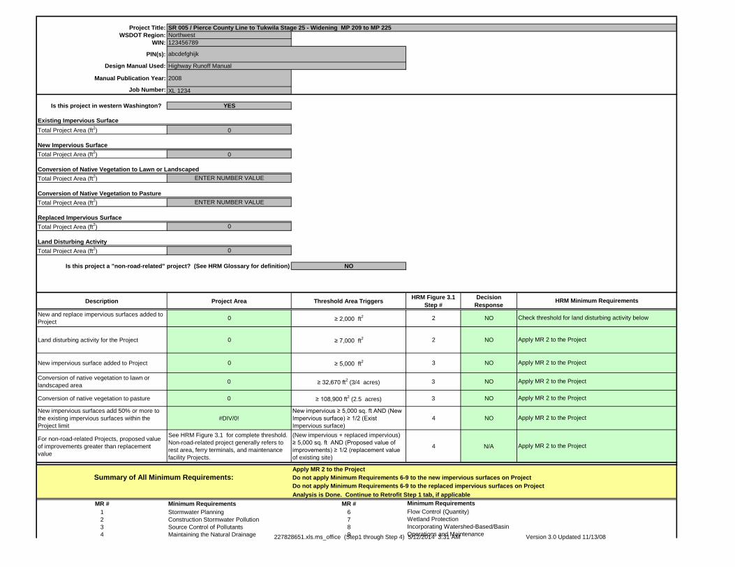
Project Title:
WSDOT Region: Northwest
WIN: 123456789
PIN(s):
Design Manual Used:
Manual Publication Year: 2008
Job Number: XL 1234
Is this project in western Washington? YES
Existing Impervious Surface
Total Project Area (ft2) 0
New Impervious Surface
Total Project Area (ft2) 0
Conversion of Native Vegetation to Lawn or Landscaped
Total Project Area (ft2) ENTER NUMBER VALUE
Conversion of Native Vegetation to Pasture
Total Project Area (ft2) ENTER NUMBER VALUE
Replaced Impervious Surface
Total Project Area (ft2) 0
Land Disturbing Activity
Total Project Area (ft2) 0
Is this project a "non-road-related" project? (See HRM Glossary for definition) NO
Description Project Area Threshold Area TriggersHRM Figure 3.1
Step #
Decision
Response
New and replace impervious surfaces added to
Project0 ≥ 2,000 ft
2 2 NO
Land disturbing activity for the Project 0 ≥ 7,000 ft2 2 NO
New impervious surface added to Project 0 ≥ 5,000 ft2 3 NO
Conversion of native vegetation to lawn or
landscaped area0 ≥ 32,670 ft
2 (3/4 acres) 3 NO
Conversion of native vegetation to pasture 0 ≥ 108,900 ft2 (2.5 acres) 3 NO
New impervious surfaces add 50% or more to
the existing impervious surfaces within the
Project limit
#DIV/0!
New impervious ≥ 5,000 sq. ft AND (New
Impervious surface) ≥ 1/2 (Exist
Impervious surface)
4 NO
For non-road-related Projects, proposed value
of improvements greater than replacement
value
See HRM Figure 3.1 for complete threshold.
Non-road-related project generally refers to
rest area, ferry terminals, and maintenance
facility Projects.
(New impervious + replaced impervious)
≥ 5,000 sq. ft AND (Proposed value of
improvements) ≥ 1/2 (replacement value
of existing site)
4 N/A
Apply MR 2 to the Project
Do not apply Minimum Requirements 6-9 to the new impervious surfaces on Project
Do not apply Minimum Requirements 6-9 to the replaced impervious surfaces on Project
Analysis is Done. Continue to Retrofit Step 1 tab, if applicable
MR # Minimum Requirements MR #
1 Stormwater Planning 6
2 Construction Stormwater Pollution 7
3 Source Control of Pollutants 8
4 Maintaining the Natural Drainage 9
SR 005 / Pierce County Line to Tukwila Stage 25 - Widening MP 209 to MP 225
Highway Runoff Manual
HRM Minimum Requirements
Check threshold for land disturbing activity below
Incorporating Watershed-Based/Basin
Operations and Maintenance
Summary of All Minimum Requirements:
abcdefghijk
Wetland Protection
Apply MR 2 to the Project
Minimum Requirements
Flow Control (Quantity)
Apply MR 2 to the Project
Apply MR 2 to the Project
Apply MR 2 to the Project
Apply MR 2 to the Project
Apply MR 2 to the Project
227828651.xls.ms_office (Step1 through Step 4) 5/12/2014 3:31 AM Version 3.0 Updated 11/13/08

5 Runoff Treatment (quality)
227828651.xls.ms_office (Step1 through Step 4) 5/12/2014 3:31 AM Version 3.0 Updated 11/13/08
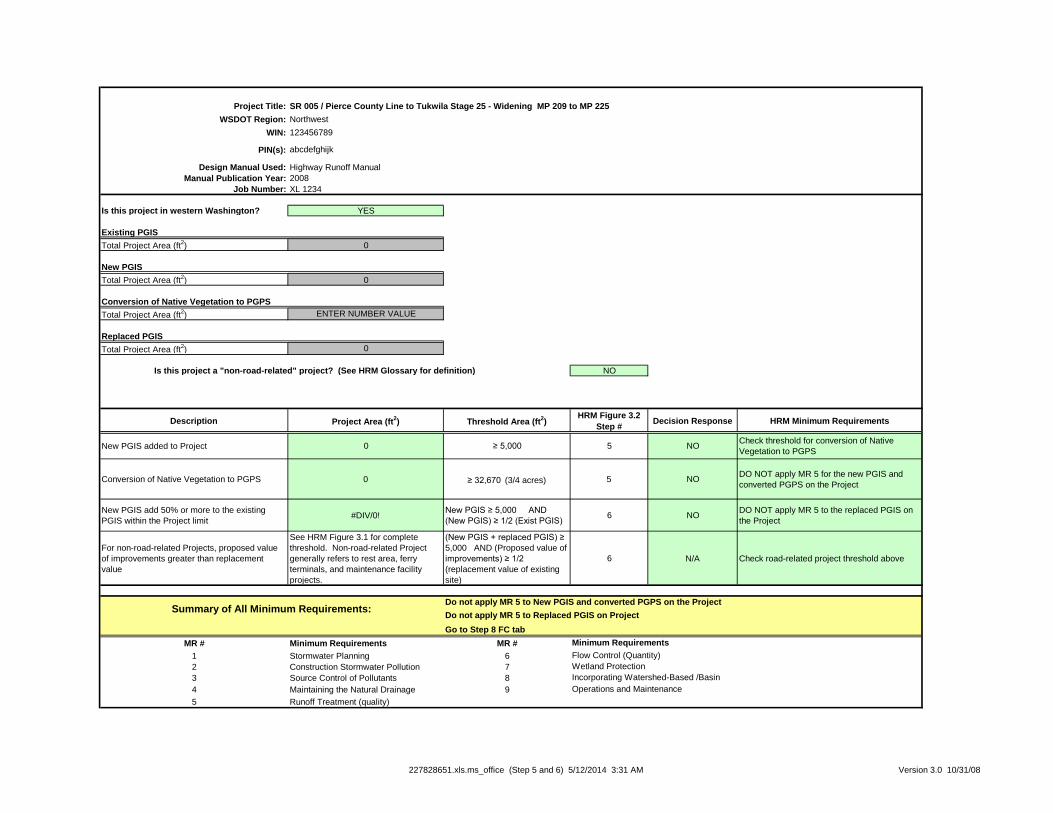
Project Title:
WSDOT Region: Northwest
WIN: 123456789
PIN(s):
Design Manual Used:
Manual Publication Year: 2008
Job Number: XL 1234
Is this project in western Washington? YES
Existing PGIS
Total Project Area (ft2) 0
New PGIS
Total Project Area (ft2) 0
Conversion of Native Vegetation to PGPS
Total Project Area (ft2) ENTER NUMBER VALUE
Replaced PGIS
Total Project Area (ft2) 0
Is this project a "non-road-related" project? (See HRM Glossary for definition) NO
Description Project Area (ft2) Threshold Area (ft
2)
HRM Figure 3.2
Step #Decision Response HRM Minimum Requirements
New PGIS added to Project 0 ≥ 5,000 5 NOCheck threshold for conversion of Native
Vegetation to PGPS
Conversion of Native Vegetation to PGPS 0 ≥ 32,670 (3/4 acres) 5 NO
DO NOT apply MR 5 for the new PGIS and
converted PGPS on the Project
New PGIS add 50% or more to the existing
PGIS within the Project limit#DIV/0!
New PGIS ≥ 5,000 AND
(New PGIS) ≥ 1/2 (Exist PGIS)6 NO
DO NOT apply MR 5 to the replaced PGIS on
the Project
For non-road-related Projects, proposed value
of improvements greater than replacement
value
See HRM Figure 3.1 for complete
threshold. Non-road-related Project
generally refers to rest area, ferry
terminals, and maintenance facility
projects.
(New PGIS + replaced PGIS) ≥
5,000 AND (Proposed value of
improvements) ≥ 1/2
(replacement value of existing
site)
6 N/A Check road-related project threshold above
Go to Step 8 FC tab
MR # Minimum Requirements MR #
1 Stormwater Planning 6
2 Construction Stormwater Pollution 7
3 Source Control of Pollutants 8
4 Maintaining the Natural Drainage 9
5 Runoff Treatment (quality)
Operations and Maintenance
Minimum Requirements
Flow Control (Quantity)
Wetland Protection
Incorporating Watershed-Based /Basin
abcdefghijk
Highway Runoff Manual
SR 005 / Pierce County Line to Tukwila Stage 25 - Widening MP 209 to MP 225
Summary of All Minimum Requirements:Do not apply MR 5 to New PGIS and converted PGPS on the Project
Do not apply MR 5 to Replaced PGIS on Project
227828651.xls.ms_office (Step 5 and 6) 5/12/2014 3:31 AM Version 3.0 10/31/08
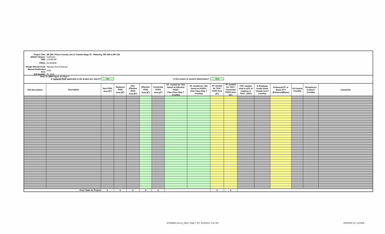
Project Title:
WSDOT Region: Northwest
WIN: 123456789
PIN(s):
Design Manual Used:
Manual Publication
Year:2008
Job Number: XL 1234
NO Is this project in western Washington? YES
TDA DescriptionNew PGIS
Area (ft2)
Replaced
PGIS
Area (ft2)
Non-
Effective
PGIS
Area (ft2)
Effective
PGIS
Area (ft2)
Converted
PGPS
Area (ft2)
RT needed for TDA
based on Effective
PGIS?
Flow Chart Step 7
(Yes/No)
RT needed for TDA
based on PGPS?
Flow Chart Step 7
(Yes/No)
RT needed
for TDA?
PGIS Area
(ft2)
RT needed
for TDA?
Converted
PGPS Area
(ft2)
If RT needed,
what is ADT of
roadway in
TDA? (ADT)
Is Roadway
inside Urban
Growth Area?
(Yes/No)
Enhanced RT or
Basic RT?
(Enhanced/Basic)
Oil Control
(Yes/No)
Phosphorus
Control?
(Yes/No)
Comments
0 0 0 0 0 0 0
Description
SR 005 / Pierce County Line to Tukwila Stage 25 - Widening MP 209 to MP 225
abcdefghijk
Highway Runoff Manual
Is replaced PGIS applicable to the project per step 6?
Refer to HRM Figure 3.3 Step 7
Area Totals for Project
227828651.xls.ms_office (Step 7 RT) 5/12/2014 3:31 AM VERSION 3.0 11/13/08
Project Title:
WSDOT Region: Northwest
WIN: 123456789
PIN(s):
Design Manual Used:
Manual Publication Year: 2008
Job Number: XL 1234
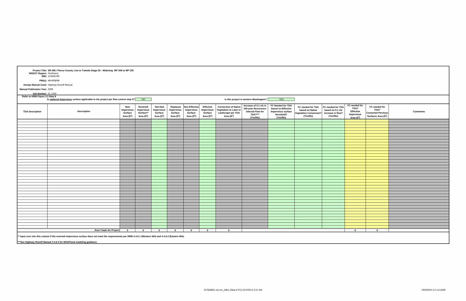
Refer to HRM Figure 3.3 Step 8
Is replaced Impervious surface applicable to the project per flow control step 5? NO Is this project in western Washington? YES
TDA Description
New
Impervious
Surface
Area (ft2)
Reverted
Impervious
Surface**
Area (ft2)
Net-New
Impervious
Surface
Area (ft2)
Replaced
Impervious
Surface
Area (ft2)
Non-Effective
Impervious
Surface
Area (ft2)
Effective
Impervious
Surface
Area (ft2)
Conversion of Native
Vegetation to Lawn or
Landscape per TDA
Area (ft2)
Increase of 0.1 cfs in
100-year Recurrence
Interval Flow for
TDA?***
(Yes/No)
FC Needed for TDA
based on Effective
Impervious surface
threshold?
(Yes/No)
FC needed for TDA
based on Native
Vegetation Conversion?
(Yes/No)
FC needed for TDA
based on 0.1 cfs
increase in flow?
(Yes/No)
FC needed for
TDA?
Effective
Impervious
Area (ft2)
FC needed for
TDA?
Converted Pervious
Surfaces Area (ft2)
Comments
0 0 0 0 0 0 0 0 0
** Input zero into this column if the reverted impervious surface does not meet the requirements per HRM 4-3.6.1 (Western WA) and 4-4.6.2 (Eastern WA).
***See Highway Runoff Manual 3-3.6.3 for MGSFlood modeling guidance.
SR 005 / Pierce County Line to Tukwila Stage 25 - Widening MP 209 to MP 225
abcdefghijk
Highway Runoff Manual
Description
Area Totals for Project
227828651.xls.ms_office (Step 8 FC) 5/12/2014 3:31 AM VERSION 3.0 11/13/08
Project Title:
WSDOT Region:
WIN:
PIN(s):
Design Manual Used:
Manual Publication Year:
Job Number:
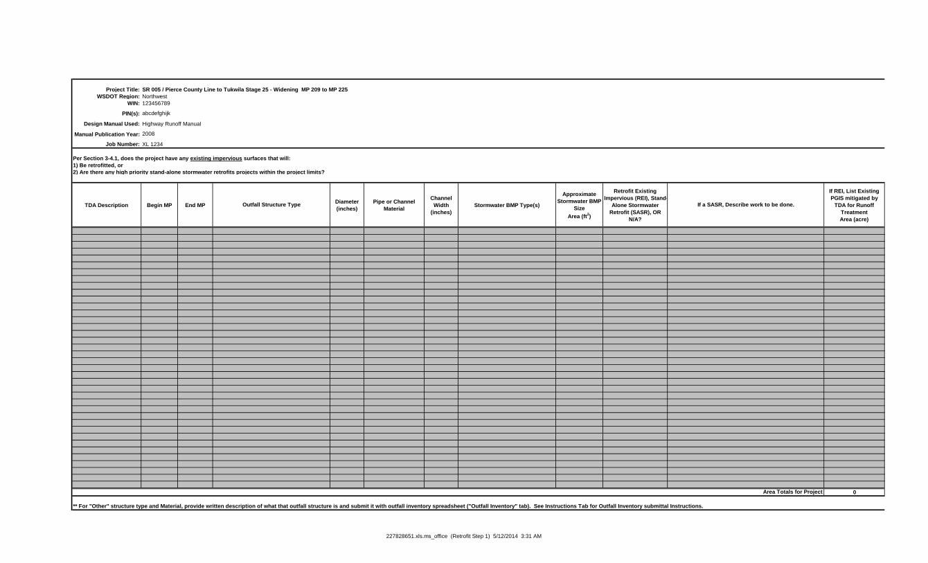
Per Section 3-4.1, does the project have any existing impervious surfaces that will:
2) Are there any high priority stand-alone stormwater retrofits projects within the project limits?
TDA Description Begin MP End MPDiameter
(inches)
Pipe or Channel
Material
Channel
Width
(inches)
Stormwater BMP Type(s)
Approximate
Stormwater BMP
Size
Area (ft2)
Retrofit Existing
Impervious (REI), Stand-
Alone Stormwater
Retrofit (SASR), OR
N/A?
If REI, List Existing
PGIS mitigated by
TDA for Runoff
Treatment
Area (acre)
0
** For "Other" structure type and Material, provide written description of what that outfall structure is and submit it with outfall inventory spreadsheet ("Outfall Inventory" tab). See Instructions Tab for Outfall Inventory submittal Instructions.
Area Totals for Project
SR 005 / Pierce County Line to Tukwila Stage 25 - Widening MP 209 to MP 225
Northwest
123456789
abcdefghijk
Highway Runoff Manual
1) Be retrofitted, or
2008
XL 1234
Outfall Structure Type If a SASR, Describe work to be done.
227828651.xls.ms_office (Retrofit Step 1) 5/12/2014 3:31 AM
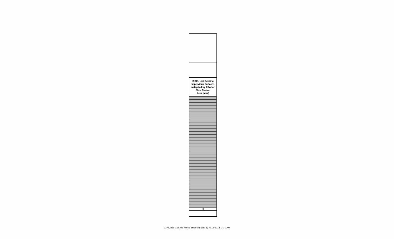
If REI, List Existing
Impervious Surfaces
mitigated by TDA for
Flow Control
Area (acre)
0
227828651.xls.ms_office (Retrofit Step 1) 5/12/2014 3:31 AM
Project Title:
WSDOT Region:
WIN:
PIN(s):
Design Manual Used:
Manual Publication Year:
Job Number:
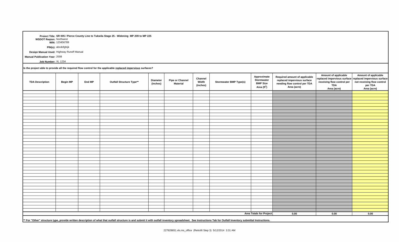
Is the project able to provide all the required flow control for the applicable replaced impervious surfaces?
TDA Description Begin MP End MP Outfall Structure Type**Diameter
(inches)
Pipe or Channel
Material
Channel
Width
(inches)
Stormwater BMP Type(s)
Approximate
Stormwater
BMP Size
Area (ft2)
Required amount of applicable
replaced impervious surface
needing flow control per TDA
Area (acre)
Amount of applicable
replaced impervious surface
receiving flow control per
TDA
Area (acre)
Amount of applicable
replaced impervious surface
not receiving flow control
per TDA
Area (acre)
0.00 0.00 0.00
** For "Other" structure type, provide written description of what that outfall structure is and submit it with outfall inventory spreadsheet. See Instructions Tab for Outfall Inventory submittal Instructions.
Highway Runoff Manual
2008
Area Totals for Project
SR 005 / Pierce County Line to Tukwila Stage 25 - Widening MP 209 to MP 225
Northwest
123456789
abcdefghijk
XL 1234
227828651.xls.ms_office (Retrofit Step 3) 5/12/2014 3:31 AM
Project Title:
WSDOT Region:
WIN:
PIN(s):
Design Manual Used:
Manual Publication Year:
Job Number:
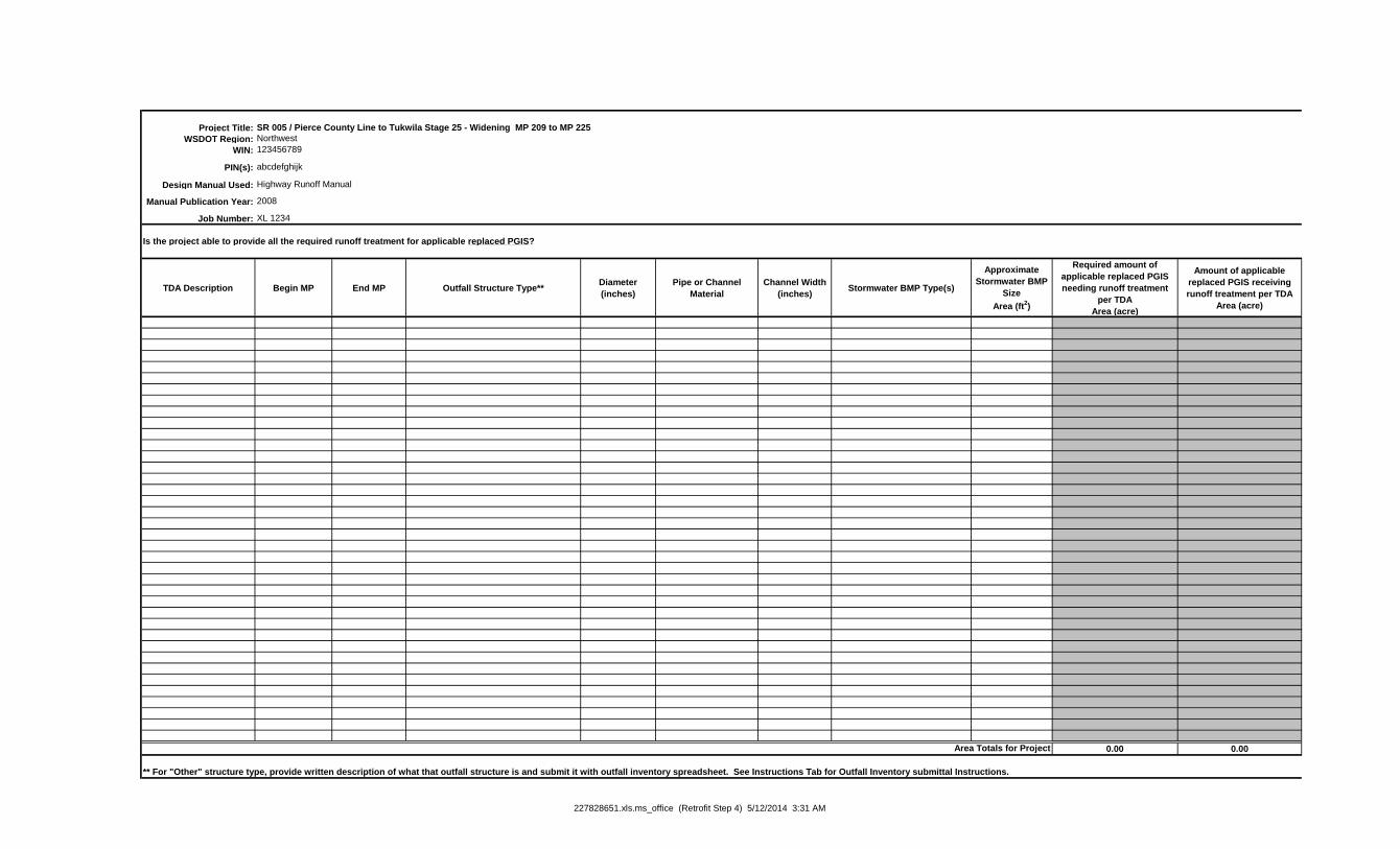
Is the project able to provide all the required runoff treatment for applicable replaced PGIS?
TDA Description Begin MP End MP Outfall Structure Type**Diameter
(inches)
Pipe or Channel
Material
Channel Width
(inches)Stormwater BMP Type(s)
Approximate
Stormwater BMP
Size
Area (ft2)
Required amount of
applicable replaced PGIS
needing runoff treatment
per TDA
Area (acre)
Amount of applicable
replaced PGIS receiving
runoff treatment per TDA
Area (acre)
0.00 0.00
** For "Other" structure type, provide written description of what that outfall structure is and submit it with outfall inventory spreadsheet. See Instructions Tab for Outfall Inventory submittal Instructions.
SR 005 / Pierce County Line to Tukwila Stage 25 - Widening MP 209 to MP 225
Northwest
123456789
Area Totals for Project
abcdefghijk
Highway Runoff Manual
2008
XL 1234
227828651.xls.ms_office (Retrofit Step 4) 5/12/2014 3:31 AM
Amount of applicable
replaced PGIS not receiving
runoff treatment per TDA
Area (acre)
0.00
227828651.xls.ms_office (Retrofit Step 4) 5/12/2014 3:31 AM
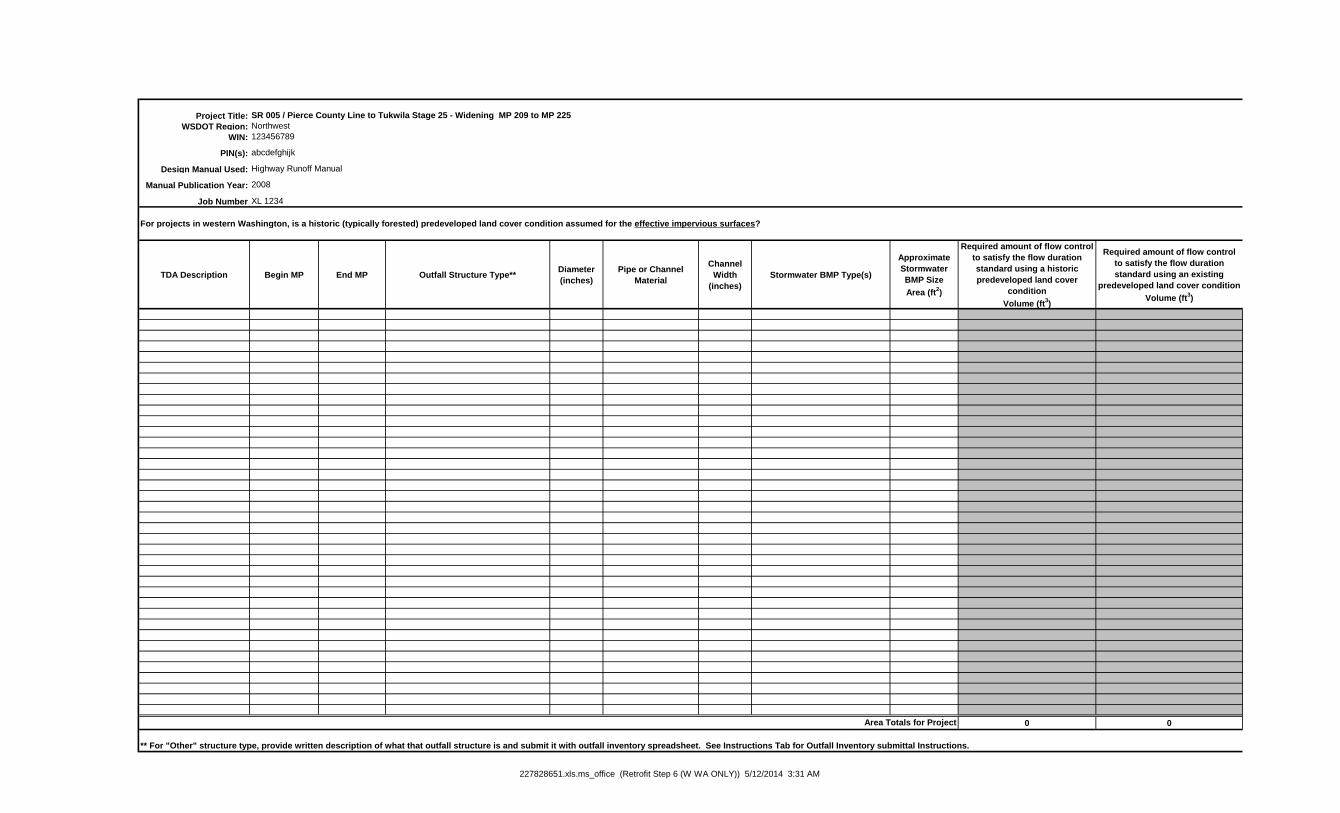
Project Title:
WSDOT Region:
WIN:
PIN(s):
Design Manual Used:
Manual Publication Year:
Job Number
For projects in western Washington, is a historic (typically forested) predeveloped land cover condition assumed for the effective impervious surfaces?
TDA Description Begin MP End MP Outfall Structure Type**Diameter
(inches)
Pipe or Channel
Material
Channel
Width
(inches)
Stormwater BMP Type(s)
Approximate
Stormwater
BMP Size
Area (ft2)
Required amount of flow control
to satisfy the flow duration
standard using a historic
predeveloped land cover
condition
Volume (ft3)
Required amount of flow control
to satisfy the flow duration
standard using an existing
predeveloped land cover condition
Volume (ft3)
0 0
** For "Other" structure type, provide written description of what that outfall structure is and submit it with outfall inventory spreadsheet. See Instructions Tab for Outfall Inventory submittal Instructions.
Area Totals for Project
Highway Runoff Manual
2008
SR 005 / Pierce County Line to Tukwila Stage 25 - Widening MP 209 to MP 225
Northwest
123456789
abcdefghijk
XL 1234
227828651.xls.ms_office (Retrofit Step 6 (W WA ONLY)) 5/12/2014 3:31 AM

Volumetric differnce between using
a historic predeveloped land cover
condition and an exisitng land
cover condition per TDA
Volume (ft3)
0
227828651.xls.ms_office (Retrofit Step 6 (W WA ONLY)) 5/12/2014 3:31 AM