Embed Size (px)
Citation preview

Storm Surge on a Coral Atoll: The Case of Fongafale Islet in Tuvalu
Lawrence BurkettUND
8 April 2016
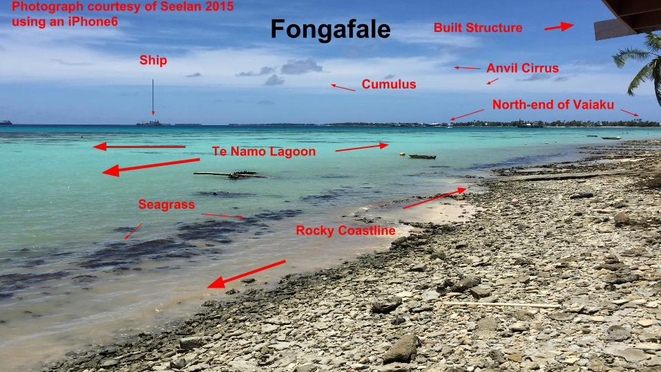
FongafaleShip
Te Namo Lagoon
Anvil Cirrus
Seagrass
CumulusNorth-end of Vaiaku
Rocky Coastline
Built StructurePhotograph courtesy of Seelan 2015using an iPhone6
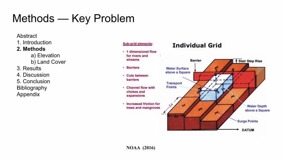
Methods — Key Problem
Abstract 1. Introduction2. Methods
a) Elevation b) Land Cover
3. Results 4. Discussion 5. Conclusion Bibliography Appendix
NOAA (2016)
Abstract 1. Introduction2. Methods
a) Elevation b) Land Cover
3. Results 4. Discussion 5. Conclusion Bibliography Appendix
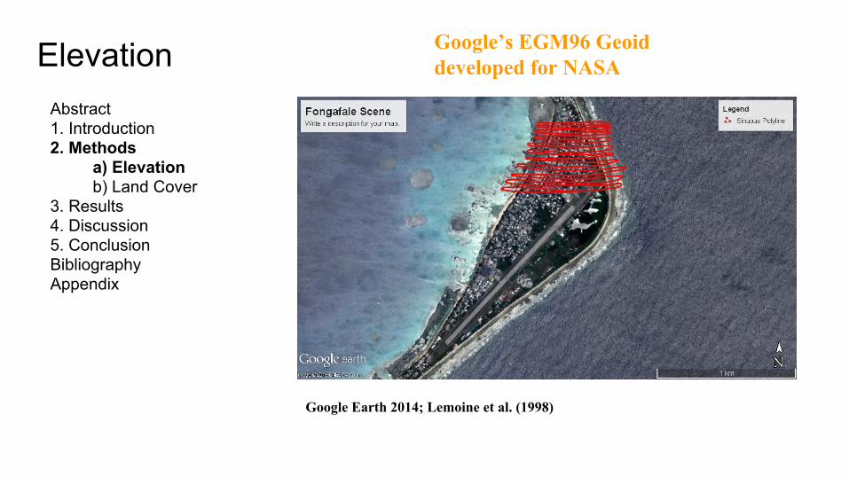
Elevation
Google’s EGM96 Geoid developed for NASA
Google Earth 2014; Lemoine et al. (1998)
Abstract 1. Introduction2. Methods
a) Elevation b) Land Cover
3. Results 4. Discussion 5. Conclusion Bibliography Appendix
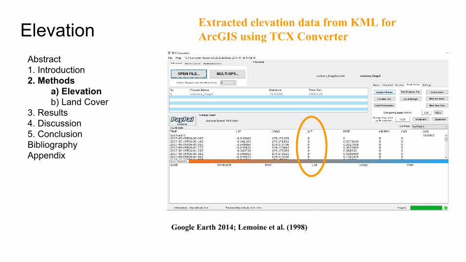
Elevation
Extracted elevation data from KML for ArcGIS using TCX Converter
Google Earth 2014; Lemoine et al. (1998)
Abstract 1. Introduction2. Methods
a) Elevation b) Land Cover
3. Results 4. Discussion 5. Conclusion Bibliography Appendix
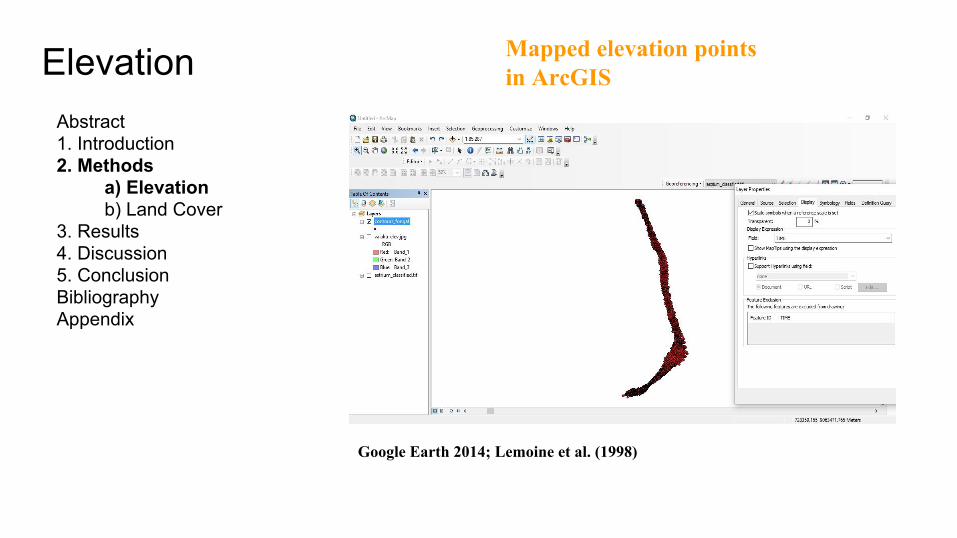
Elevation
Mapped elevation points in ArcGIS
Google Earth 2014; Lemoine et al. (1998)
Abstract 1. Introduction2. Methods
a) Elevation b) Land Cover
3. Results 4. Discussion 5. Conclusion Bibliography Appendix
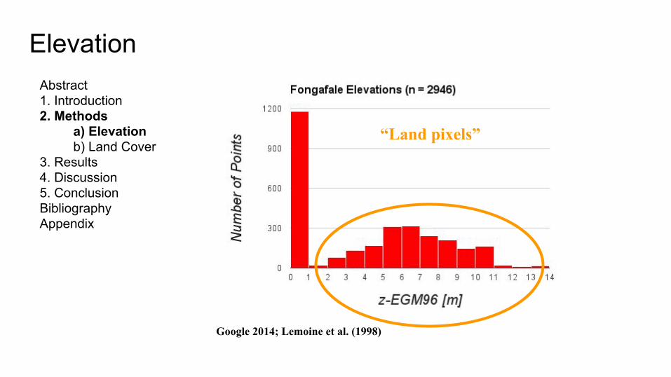
Google 2014; Lemoine et al. (1998)
“Land pixels”
Elevation
Abstract 1. Introduction2. Methods
a) Elevation b) Land Cover
3. Results 4. Discussion 5. Conclusion Bibliography Appendix
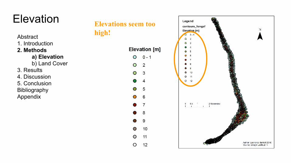
Elevation
Elevations seem too high!
Abstract 1. Introduction2. Methods
a) Elevation b) Land Cover
3. Results 4. Discussion 5. Conclusion Bibliography Appendix
Elevation
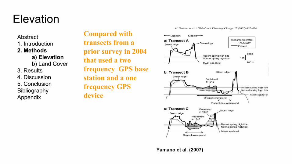
Yamano et al. (2007)
Compared with transects from a prior survey in 2004 that used a two frequency GPS base station and a one frequency GPS device
Abstract 1. Introduction2. Methods
a) Elevation b) Land Cover
3. Results 4. Discussion 5. Conclusion Bibliography Appendix
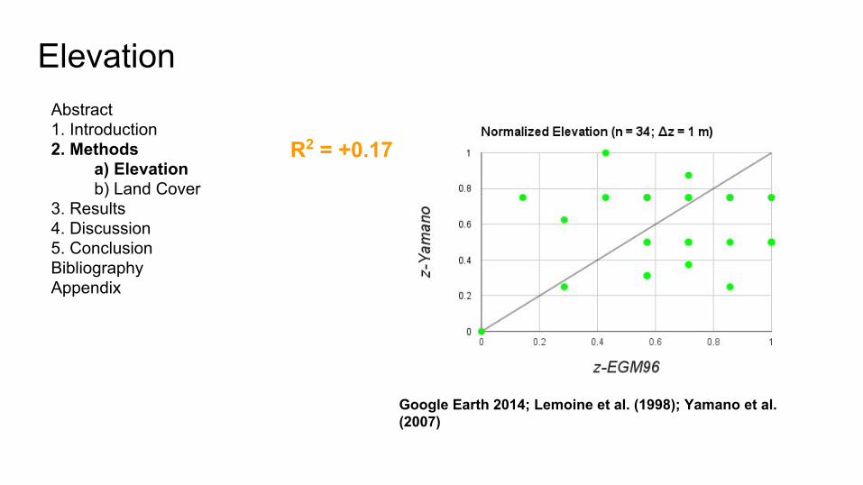
Elevation
Google Earth 2014; Lemoine et al. (1998); Yamano et al. (2007)
R2 = +0.17

Abstract 1. Introduction2. Methods
a) Elevation b) Land Cover
3. Results 4. Discussion 5. Conclusion Bibliography Appendix
Elevation
Google Earth 2014; Lemoine et al. (1998); iPhone6 2015
R2 = -0.05
iPhone6 reports elevation but this is from a pressure sensor
Abstract 1. Introduction2. Methods
a) Elevation b) Land Cover
3. Results 4. Discussion 5. Conclusion Bibliography Appendix
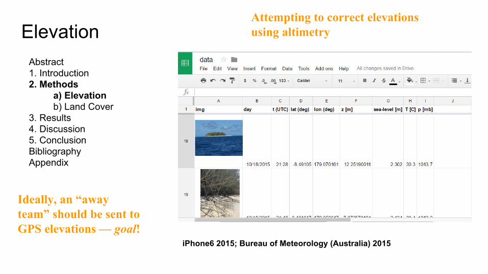
Elevation
iPhone6 2015; Bureau of Meteorology (Australia) 2015
Attempting to correct elevations using altimetry
Ideally, an “away team” should be sent to GPS elevations — goal!
Abstract 1. Introduction2. Methods
a) Elevation b) Land Cover
3. Results 4. Discussion 5. Conclusion Bibliography Appendix
Elevation
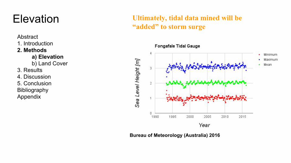
Bureau of Meteorology (Australia) 2016
Ultimately, tidal data mined will be “added” to storm surge
Land Cover
Abstract 1. Introduction2. Methods
a) Elevation b) Land Cover
3. Results 4. Discussion 5. Conclusion Bibliography Appendix
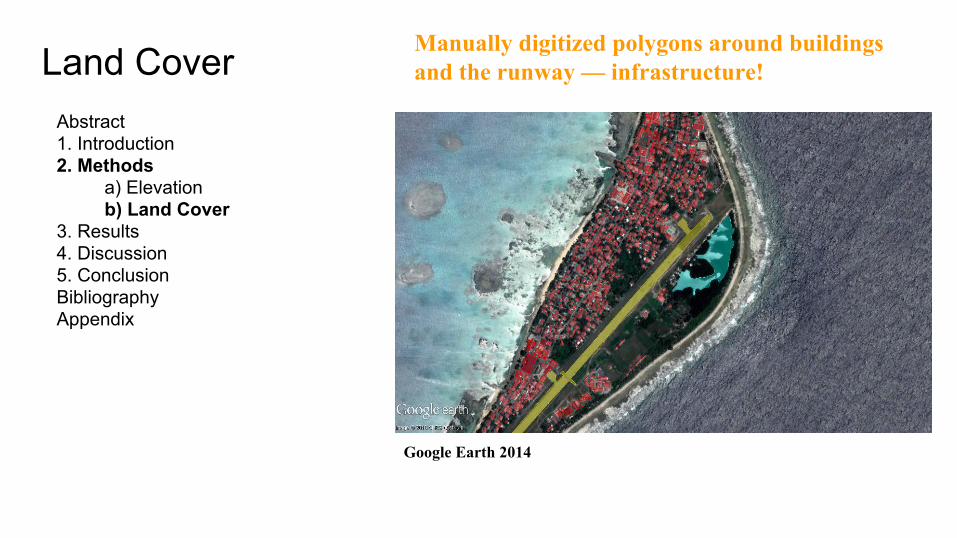
Manually digitized polygons around buildings and the runway — infrastructure!
Google Earth 2014
Land Cover
Abstract 1. Introduction2. Methods
a) Elevation b) Land Cover
3. Results 4. Discussion 5. Conclusion Bibliography Appendix
Google Earth 2014
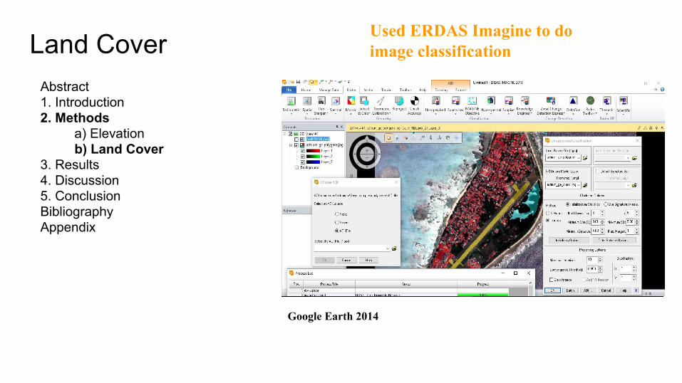
Used ERDAS Imagine to do image classification
Land Cover
Abstract 1. Introduction2. Methods
a) Elevation b) Land Cover
3. Results 4. Discussion 5. Conclusion Bibliography Appendix
Google Earth 2014
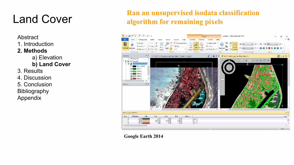
Ran an unsupervised isodata classification algorithm for remaining pixels
Land Cover
Abstract 1. Introduction2. Methods
a) Elevation b) Land Cover
3. Results 4. Discussion 5. Conclusion Bibliography Appendix
Google Earth 2014
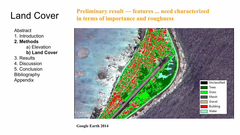
Preliminary result — features ... need characterized in terms of importance and roughness

Abstract 1. Introduction2. Methods 3. Results 4. Discussion 5. Conclusion Bibliography
I. LiteratureII. Software
Appendix
Bibliography
Lemoine, Frank G., Steve C. Kenyon, John K. Factor, Ronald G. Trimmer, Nikolaos K. Pavlis, Douglas S. Chinn, Christopher M. Cox et al. "The development of the joint NASA GSFC and the National Imagery and Mapping Agency (NIMA) geopotential model EGM96." (1998).
National Oceanic and Atmospheric Administration (NOAA). “Storm Surge and Coastal Inundation.” http://www.stormsurge.noaa.gov/models_observations.html (accessed: February 15, 2016).
Yamano, Hiroya, Hajime Kayanne, Toru Yamaguchi, Yuji Kuwahara, Hiromune Yokoki, Hiroto Shimazaki, and Masashi Chikamori. "Atoll island vulnerability to flooding and inundation revealed by historical reconstruction: Fongafale Islet, Funafuti Atoll, Tuvalu." Global and Planetary Change 57, no. 3 (2007): 407-416
“Abbreviated” listing
Abstract 1. Introduction2. Methods 3. Results 4. Discussion 5. Conclusion Bibliography
I. LiteratureII. Software
Appendix
Bibliography
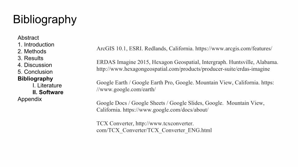
ArcGIS 10.1, ESRI. Redlands, California. https://www.arcgis.com/features/
ERDAS Imagine 2015, Hexagon Geospatial, Intergraph. Huntsville, Alabama. http://www.hexagongeospatial.com/products/producer-suite/erdas-imagine
Google Earth / Google Earth Pro, Google. Mountain View, California. https://www.google.com/earth/
Google Docs / Google Sheets / Google Slides, Google. Mountain View, California. https://www.google.com/docs/about/
TCX Converter, http://www.tcxconverter.com/TCX_Converter/TCX_Converter_ENG.html

Abstract 1. Introduction2. Methods 3. Results 4. Discussion 5. Conclusion Bibliography Appendix
Questions
?