Embed Size (px)
Citation preview
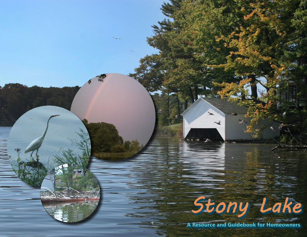
A Resource and Guidebook for Homeowners
Stony Lake
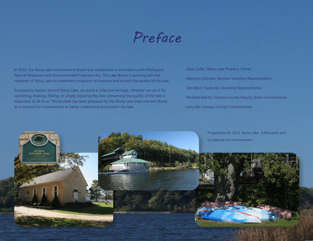
In 2010, the Stony Lake Improvement Board was established in accordance with Michigan’s Natural Resources and Environmental Protection Act. The Lake Board is working with the residents of Stony Lake to implement programs to improve and protect the quality of the lake.
As property owners around Stony Lake, we share a collective heritage. Whether we use it for
important to all of us. This booklet has been prepared by the Stony Lake Improvement Board as a resource for homeowners to better understand and protect the lake.
Preface
Dave Zoller, Stony Lake Property Owner
MaryLou Schuyler, Benona Township Representative
Tom Best, Claybanks Township Representative
Michelle Martin, Oceana County Deputy Drain Commissioner
Larry Byl, Oceana County Commissioner
Progressive AE. 2014. Stony Lake: A Resource and
Guidebook for Homeowners
An Historical Perspective ..................................................................................................................................................... p. 1-‐2
Lake Facts ................................................................................................................................................................................... p. 3-‐4
Watershed Facts ...................................................................................................................................................................... p. 5-‐6
Water Quality ............................................................................................................................................................................ p. 7-‐8
Aquatic Plants ........................................................................................................................................................................p. 9-‐10
What You Can Do .............................................................................................................................................................. p. 11-‐12
Contents
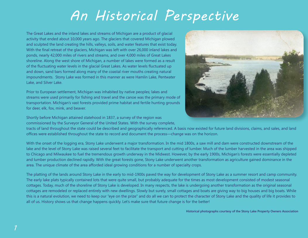
An Historical Perspective
1
The Great Lakes and the inland lakes and streams of Michigan are a product of glacial activity that ended about 10,000 years ago. The glaciers that covered Michigan plowed and sculpted the land creating the hills, valleys, soils, and water features that exist today.
ponds, nearly 42,000 miles of rivers and streams, and over 4,000 miles of Great Lakes shoreline. Along the west shore of Michigan, a number of lakes were formed as a result
and down, sand bars formed along many of the coastal river mouths creating natural impoundments. Stony Lake was formed in this manner as were Hamlin Lake, Pentwater Lake, and Silver Lake.
Prior to European settlement, Michigan was inhabited by native peoples; lakes and
transportation. Michigan’s vast forests provided prime habitat and fertile hunting grounds for deer, elk, fox, mink, and beaver.
Shortly before Michigan attained statehood in 1837, a survey of the region was commissioned by the Surveyor General of the United States. With the survey complete, tracts of land throughout the state could be described and geographically referenced. A basis now existed for future land divisions, claims, and sales, and land
lake and the level of Stony Lake was raised several feet to facilitate the transport and cutting of lumber. Much of the lumber harvested in the area was shipped to Chicago and Milwaukee to fuel the tremendous growth underway in the Midwest. However, by the early 1900s, Michigan’s forests were essentially depleted and lumber production declined rapidly. With the great forests gone, Stony Lake underwent another transformation as agriculture gained dominance in the area. The unique climate of the area afforded ideal growing conditions for a number of specialty crops.
The platting of the lands around Stony Lake in the early to mid-‐1900s paved the way for development of Stony Lake as a summer resort and camp community. The early lake plats typically contained lots that were quite small, but probably adequate for the times as most development consisted of modest seasonal cottages. Today, much of the shoreline of Stony Lake is developed. In many respects, the lake is undergoing another transformation as the original seasonal cottages are remodeled or replaced entirely with new dwellings. Slowly but surely, small cottages and boats are giving way to big houses and big boats. While
all of us. History shows us that change happens quickly. Let’s make sure that future change is for the better!
Historical photographs courtesy of the Stony Lake Property Owners Association
2
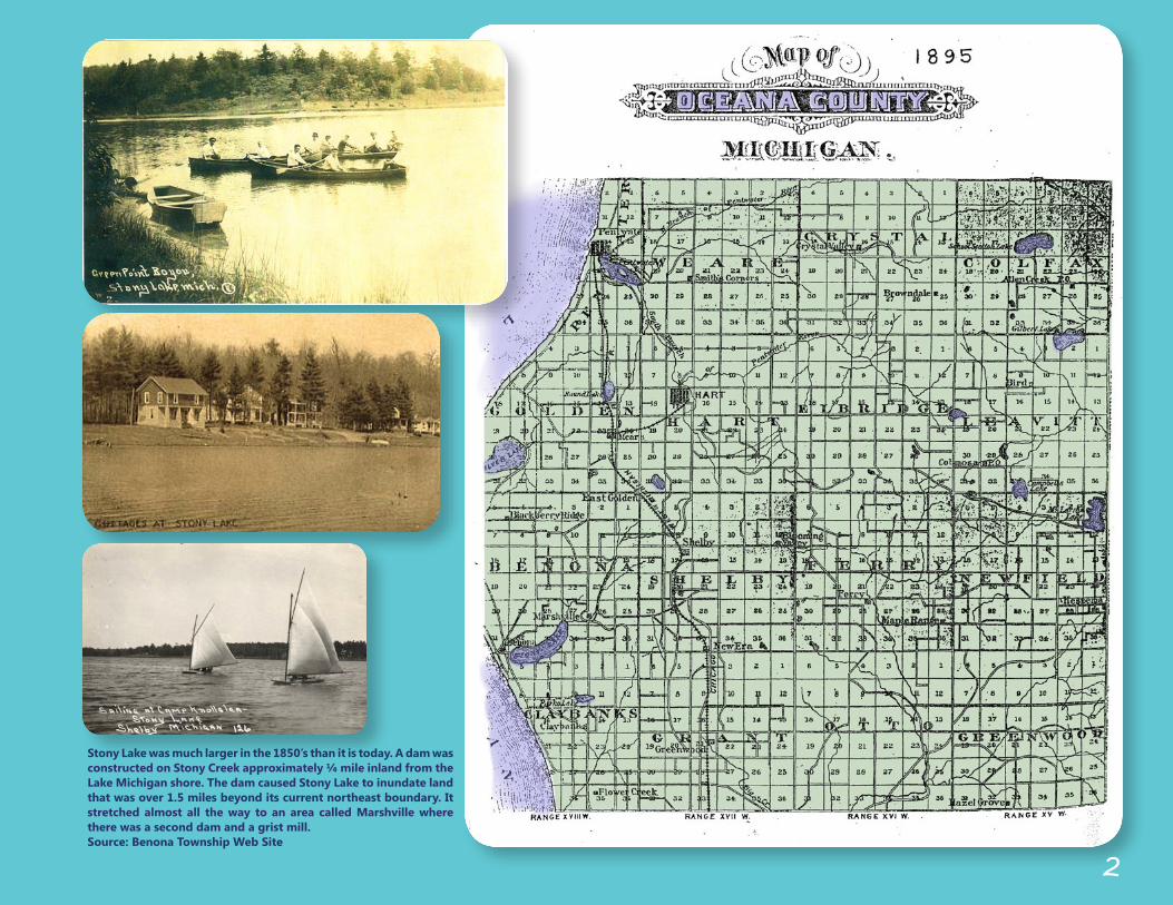
Stony Lake was much larger in the 1850’s than it is today. A dam was constructed on Stony Creek approximately ¼ mile inland from the Lake Michigan shore. The dam caused Stony Lake to inundate land that was over 1.5 miles beyond its current northeast boundary. It stretched almost all the way to an area called Marshville where there was a second dam and a grist mill. Source: Benona Township Web Site
3
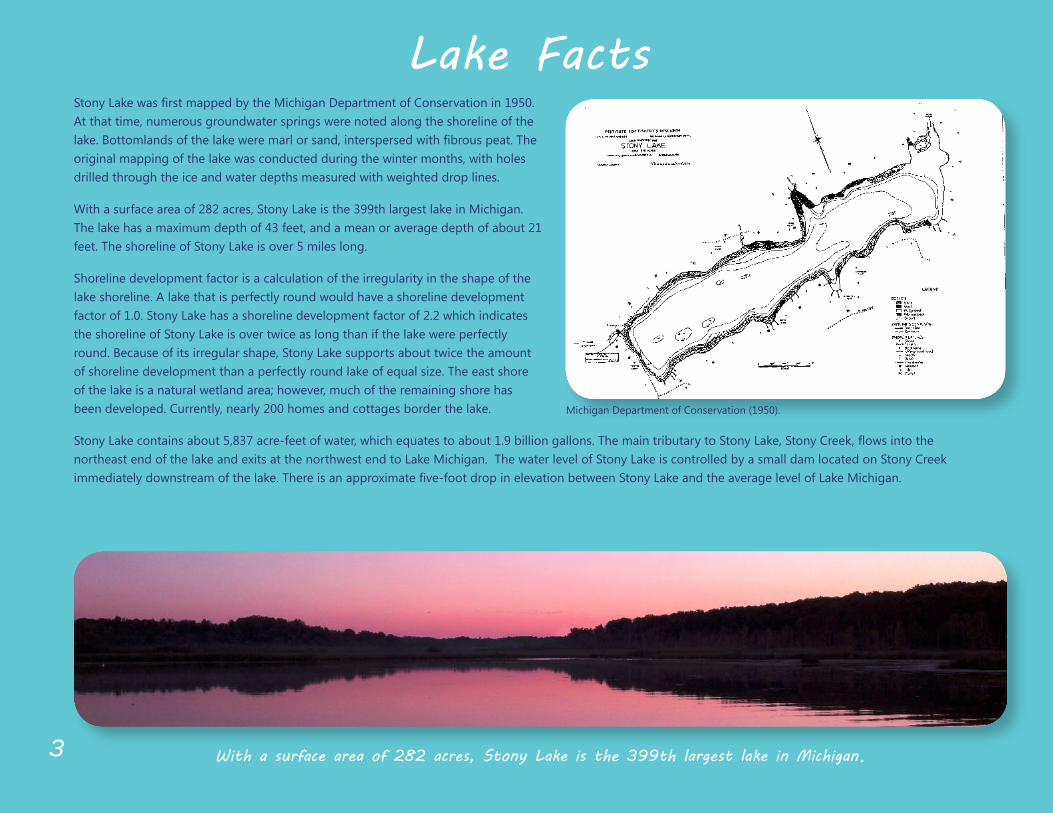
Lake FactsAt that time, numerous groundwater springs were noted along the shoreline of the
original mapping of the lake was conducted during the winter months, with holes drilled through the ice and water depths measured with weighted drop lines.
With a surface area of 282 acres, Stony Lake is the 399th largest lake in Michigan. The lake has a maximum depth of 43 feet, and a mean or average depth of about 21 feet. The shoreline of Stony Lake is over 5 miles long.
Shoreline development factor is a calculation of the irregularity in the shape of the lake shoreline. A lake that is perfectly round would have a shoreline development factor of 1.0. Stony Lake has a shoreline development factor of 2.2 which indicates the shoreline of Stony Lake is over twice as long than if the lake were perfectly round. Because of its irregular shape, Stony Lake supports about twice the amount
of the lake is a natural wetland area; however, much of the remaining shore has been developed. Currently, nearly 200 homes and cottages border the lake.
northeast end of the lake and exits at the northwest end to Lake Michigan. The water level of Stony Lake is controlled by a small dam located on Stony Creek
With a surface area of 282 acres, Stony Lake is the 399th largest lake in Michigan.
Michigan Department of Conservation (﴾1950)﴿.
4
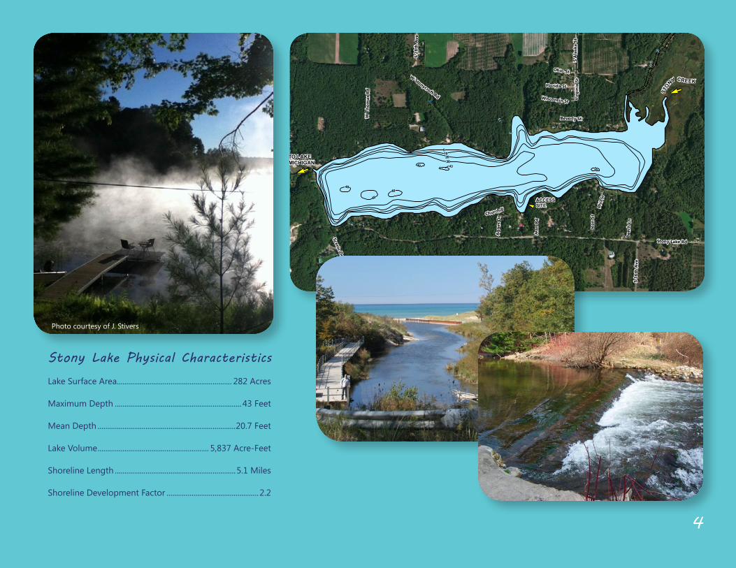
Stony Lake Physical Characteristics
Lake Surface Area............................................................ 282 Acres
Maximum Depth .................................................................. 43 Feet
Mean Depth ........................................................................20.7 Feet
Lake Volume .......................................................... 5,837 Acre-‐Feet
Shoreline Length ...............................................................5.1 Miles
Shoreline Development Factor ................................................2.2
STON
Y CREEK
E
TO LAKEMICHIGAN
E
43
! ACCESSSITE
0
5
0
102030
40
40
30
0
40
4040
Scenic Dr
Stony Lake Rd
W T
hom
as R
d
Beverly St
Ohio StW Stonycroft Rd
Phil
St
Churchill
S A
lask
a St
S 36
th A
ve
Virg
inia
St
Jean
St
Jean
Rd
Beec
h Ln
Florida St
S 28
th A
ve
Agn
es D
r
Wisconsin St
Source: Esri, DigitalGlobe, GeoEye, i-cubed, USDA, USGS, AEX, Getmapping, Aerogrid, IGN, IGP,swisstopo, and the GIS User Community
STONY LAKEDEPTH CONTOUR MAPOCEANA COUNTY, MICHIGANSOURCE: DEPTH CONTOURS PROVIDED BY MICHIGAN CONSERVATION DEPARTMENT 1950
´1 inch = 1,000 feet
Photo courtesy of J. Stivers
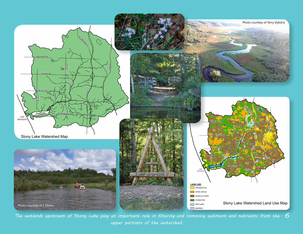
Watershed Facts
Primary controllable sources of pollution in the Stony Lake watershed include lawn fertilizer and septic system seepage.
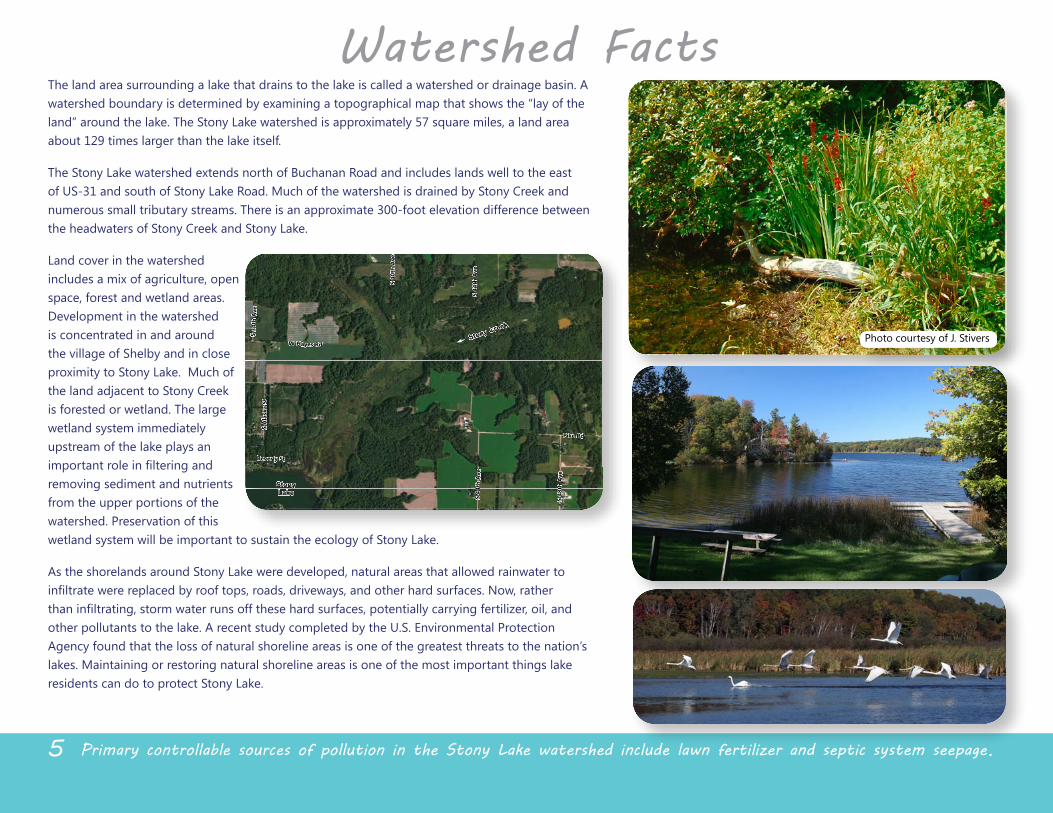
The land area surrounding a lake that drains to the lake is called a watershed or drainage basin. A watershed boundary is determined by examining a topographical map that shows the “lay of the
about 129 times larger than the lake itself.
The Stony Lake watershed extends north of Buchanan Road and includes lands well to the east of US-‐31 and south of Stony Lake Road. Much of the watershed is drained by Stony Creek and numerous small tributary streams. There is an approximate 300-‐foot elevation difference between the headwaters of Stony Creek and Stony Lake.
Land cover in the watershed includes a mix of agriculture, open space, forest and wetland areas. Development in the watershed is concentrated in and around the village of Shelby and in close proximity to Stony Lake. Much of
is forested or wetland. The large wetland system immediately upstream of the lake plays an
removing sediment and nutrients from the upper portions of the watershed. Preservation of this wetland system will be important to sustain the ecology of Stony Lake.
As the shorelands around Stony Lake were developed, natural areas that allowed rainwater to
other pollutants to the lake. A recent study completed by the U.S. Environmental Protection Agency found that the loss of natural shoreline areas is one of the greatest threats to the nation’s lakes. Maintaining or restoring natural shoreline areas is one of the most important things lake residents can do to protect Stony Lake.
5
Photo courtesy of J. Stivers
Pike Rd
Stony Lake Rd
W Hayes Rd
S 44
th A
ve
S 48
th A
ve
S 34
th A
ve
S 40
th A
ve
S A
lask
a St
Beverly St
Phil
St
S 44
th A
ve
Source: Esri, DigitalGlobe, GeoEye, i-cubed, USDA, USGS, AEX, Getmapping, Aerogrid, IGN, IGP,swisstopo, and the GIS User Community
Stony Cre
ek
E
StonyLake
Ston
y Cr
eek
W Buchanan Rd
W Shelby Rd
W Grant Rd
S 28
th A
ve
S 48
th A
ve
S US
31
Hart Montague
N S
tate
St
Stony Lake RdSTONY LAKE
LAKEMICHIGAN
SOURCE: LAND USE DATA PROVIDED BY THE MICHIGAN DEPARTMENT OF NATURAL RESOURCES & ENVIRONMENT
STONY LAKELAND USE MAPOCEANA COUNTY, MICHIGAN
´NO SCALE
LAND USERESIDENTIAL
OPEN SPACE
AGRICULTURAL
FORESTED
WETLAND
BARREN
The wetlands upstream of Stony Lake play an important role in filtering and removing sediment and nutrients from the upper portions of the watershed.
Photo courtesy of J. Stivers
Photo courtesy of Terry Dykstra
Stony Lake Watershed Map
Stony Lake Watershed Land Use Map
6
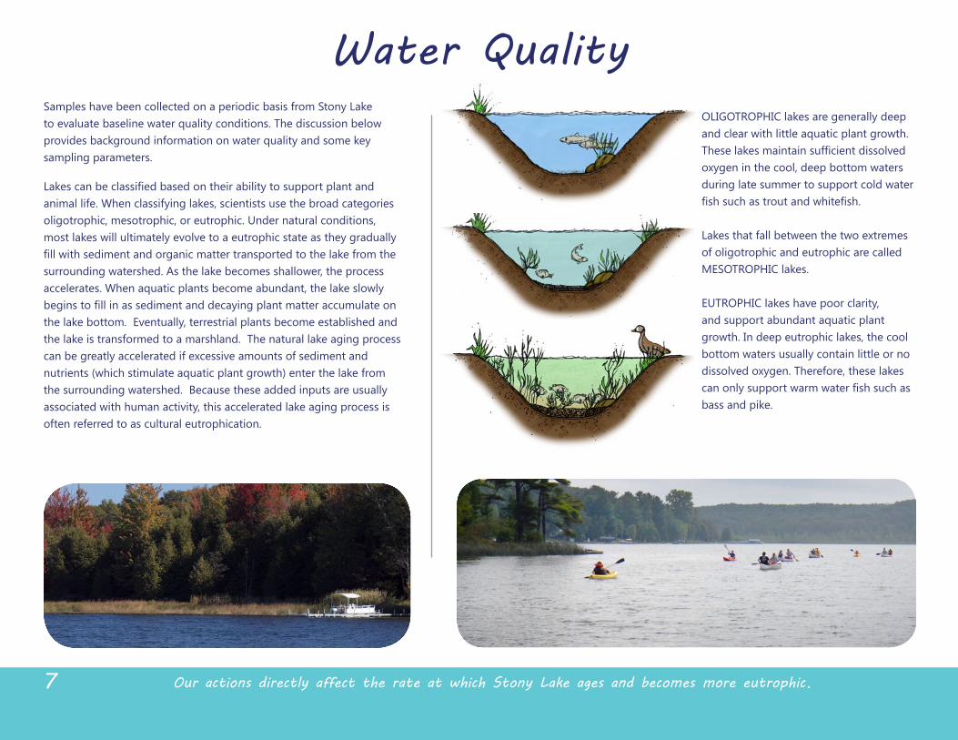
OLIGOTROPHIC lakes are generally deep and clear with little aquatic plant growth.
oxygen in the cool, deep bottom waters during late summer to support cold water
Lakes that fall between the two extremes of oligotrophic and eutrophic are called MESOTROPHIC lakes. EUTROPHIC lakes have poor clarity, and support abundant aquatic plant growth. In deep eutrophic lakes, the cool bottom waters usually contain little or no dissolved oxygen. Therefore, these lakes
bass and pike.
Water QualitySamples have been collected on a periodic basis from Stony Lake to evaluate baseline water quality conditions. The discussion below provides background information on water quality and some key sampling parameters.
animal life. When classifying lakes, scientists use the broad categories oligotrophic, mesotrophic, or eutrophic. Under natural conditions, most lakes will ultimately evolve to a eutrophic state as they gradually
surrounding watershed. As the lake becomes shallower, the process accelerates. When aquatic plants become abundant, the lake slowly
the lake bottom. Eventually, terrestrial plants become established and the lake is transformed to a marshland. The natural lake aging process can be greatly accelerated if excessive amounts of sediment and nutrients (﴾which stimulate aquatic plant growth)﴿ enter the lake from the surrounding watershed. Because these added inputs are usually associated with human activity, this accelerated lake aging process is often referred to as cultural eutrophication.
Our actions directly affect the rate at which Stony Lake ages and becomes more eutrophic. 7
8Stony Lake is moderately eutrophic.
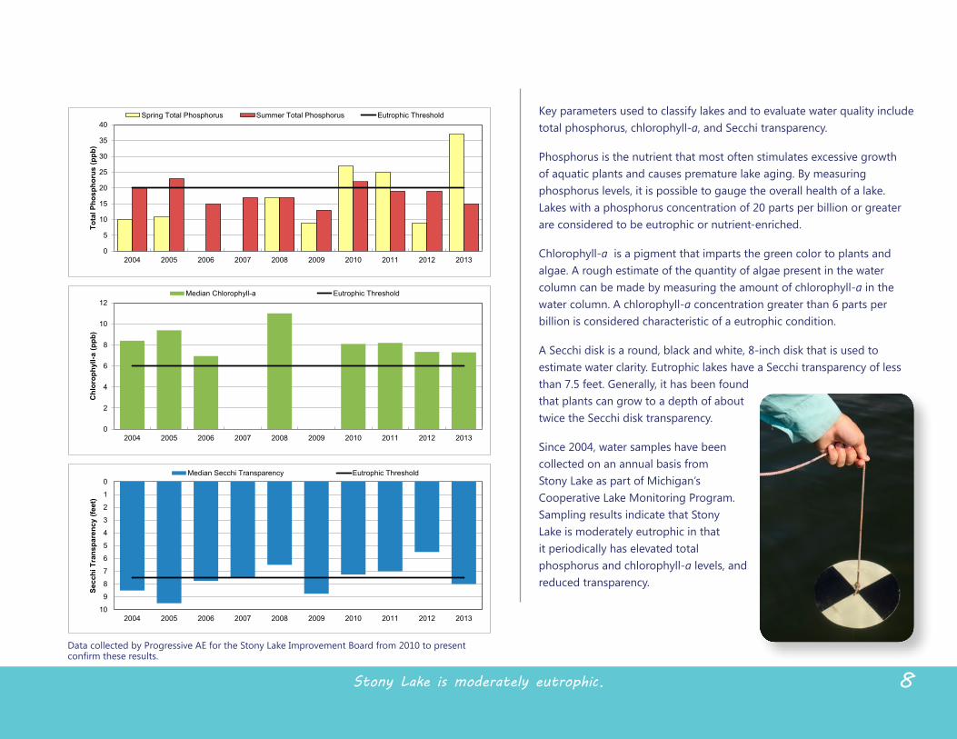
Key parameters used to classify lakes and to evaluate water quality include total phosphorus, chlorophyll-‐a, and Secchi transparency.
Phosphorus is the nutrient that most often stimulates excessive growth of aquatic plants and causes premature lake aging. By measuring phosphorus levels, it is possible to gauge the overall health of a lake. Lakes with a phosphorus concentration of 20 parts per billion or greater are considered to be eutrophic or nutrient-‐enriched.
Chlorophyll-‐a is a pigment that imparts the green color to plants and algae. A rough estimate of the quantity of algae present in the water column can be made by measuring the amount of chlorophyll-‐a in the water column. A chlorophyll-‐a concentration greater than 6 parts per billion is considered characteristic of a eutrophic condition.
A Secchi disk is a round, black and white, 8-‐inch disk that is used to estimate water clarity. Eutrophic lakes have a Secchi transparency of less than 7.5 feet. Generally, it has been found that plants can grow to a depth of about twice the Secchi disk transparency.
Since 2004, water samples have been collected on an annual basis from Stony Lake as part of Michigan’s Cooperative Lake Monitoring Program. Sampling results indicate that Stony Lake is moderately eutrophic in that it periodically has elevated total phosphorus and chlorophyll-‐a levels, and reduced transparency.
0
5
10
15
20
25
30
35
40
2004 2005 2006 2007 2008 2009 2010 2011 2012 2013
Total Phosphorus (ppb)
Spring Total Phosphorus Summer Total Phosphorus Eutrophic Threshold
0
2
4
6
8
10
12
2004 2005 2006 2007 2008 2009 2010 2011 2012 2013
Chlorophyll-a (ppb)
Median Chlorophyll-a Eutrophic Threshold
0
1
2
3
4
5
6
7
8
9
102004 2005 2006 2007 2008 2009 2010 2011 2012 2013
Secchi Transparency (feet)
Median Secchi Transparency Eutrophic Threshold
Data collected by Progressive AE for the Stony Lake Improvement Board from 2010 to present
0
5
10
15
20
25
30
35
40
2004 2005 2006 2007 2008 2009 2010 2011 2012 2013
Total Phosphorus (ppb)
Spring Total Phosphorus Summer Total Phosphorus Eutrophic Threshold
0
2
4
6
8
10
12
2004 2005 2006 2007 2008 2009 2010 2011 2012 2013
Chlorophyll-a (ppb)
Median Chlorophyll-a Eutrophic Threshold
0
1
2
3
4
5
6
7
8
9
102004 2005 2006 2007 2008 2009 2010 2011 2012 2013
Secchi Transparency (feet)
Median Secchi Transparency Eutrophic Threshold
0
5
10
15
20
25
30
35
40
2004 2005 2006 2007 2008 2009 2010 2011 2012 2013
Total Phosphorus (ppb)
Spring Total Phosphorus Summer Total Phosphorus Eutrophic Threshold
0
2
4
6
8
10
12
2004 2005 2006 2007 2008 2009 2010 2011 2012 2013
Chlorophyll-a (ppb)
Median Chlorophyll-a Eutrophic Threshold
0
1
2
3
4
5
6
7
8
9
102004 2005 2006 2007 2008 2009 2010 2011 2012 2013
Secchi Transparency (feet)
Median Secchi Transparency Eutrophic Threshold
Aquatic plants are an essential component of the lake environment.
Aquatic Plants
9
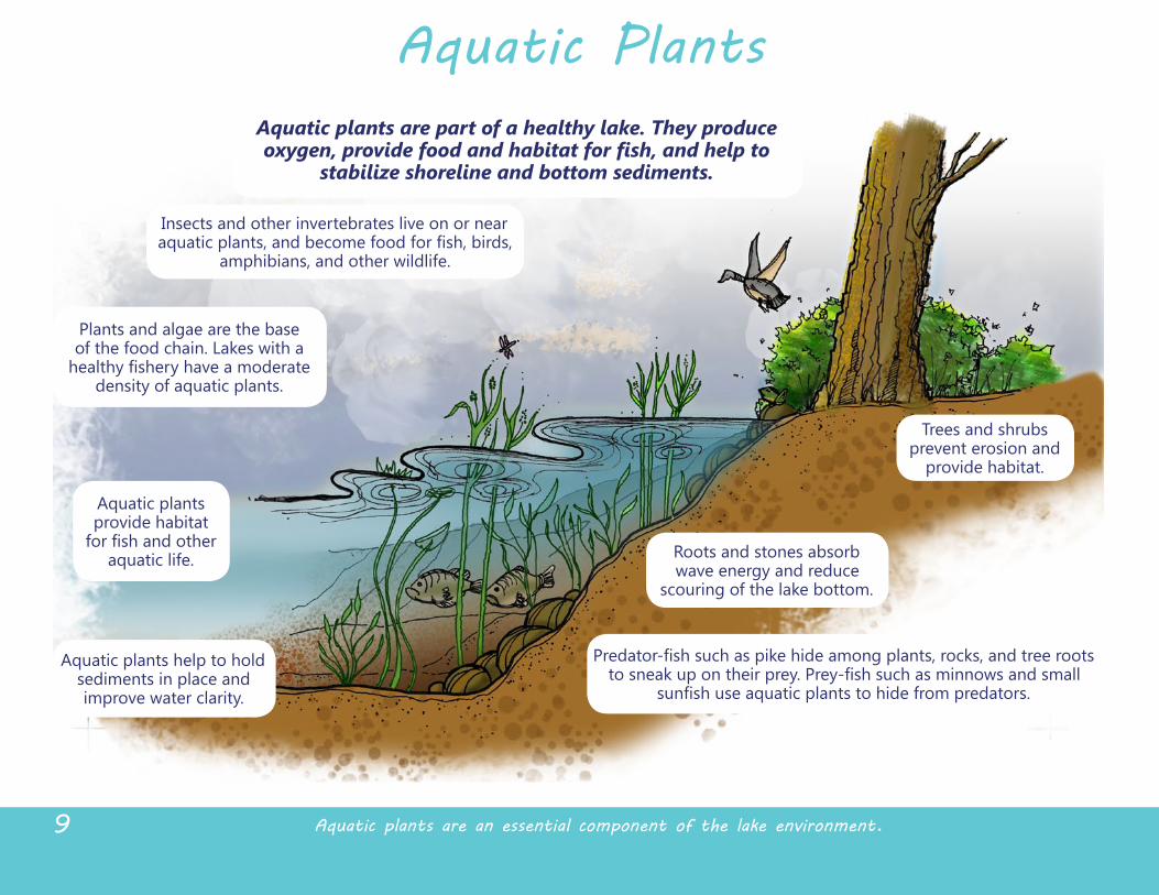
Aquatic plants are part of a healthy lake. They produce
stabilize shoreline and bottom sediments.
Insects and other invertebrates live on or near
amphibians, and other wildlife.
Plants and algae are the base of the food chain. Lakes with a
density of aquatic plants.
Aquatic plants provide habitat
aquatic life.
Aquatic plants help to hold sediments in place and improve water clarity.
Roots and stones absorb wave energy and reduce
scouring of the lake bottom.
Trees and shrubs prevent erosion and
provide habitat.
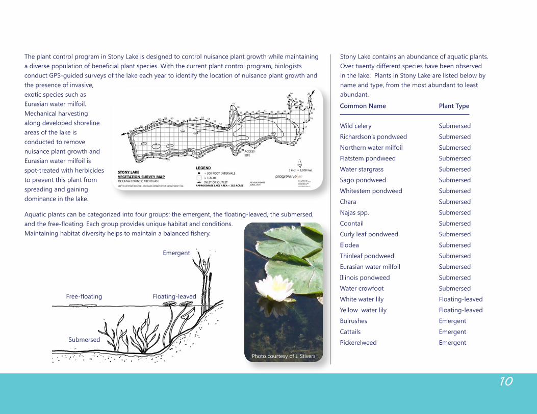
The plant control program in Stony Lake is designed to control nuisance plant growth while maintaining
conduct GPS-‐guided surveys of the lake each year to identify the location of nuisance plant growth and the presence of invasive, exotic species such as Eurasian water milfoil. Mechanical harvesting along developed shoreline areas of the lake is conducted to remove nuisance plant growth and Eurasian water milfoil is spot-‐treated with herbicides to prevent this plant from spreading and gaining dominance in the lake.
Common Name Plant Type
Wild celery Submersed
Richardson’s pondweed Submersed
Northern water milfoil Submersed
Flatstem pondweed Submersed
Water stargrass Submersed
Sago pondweed Submersed
Whitestem pondweed Submersed
Chara Submersed
Coontail Submersed
Curly leaf pondweed Submersed
Elodea Submersed
Thinleaf pondweed Submersed
Eurasian water milfoil Submersed
Illinois pondweed Submersed
Water crowfoot Submersed
White water lily Floating-‐leaved
Yellow water lily Floating-‐leaved
Bulrushes Emergent
Cattails Emergent
Pickerelweed Emergent
10
Floating-‐leaved
Emergent
Submersed
Free-‐floating
Stony Lake contains an abundance of aquatic plants. Over twenty different species have been observed in the lake. Plants in Stony Lake are listed below by name and type, from the most abundant to least abundant.
Photo courtesy of J. Stivers
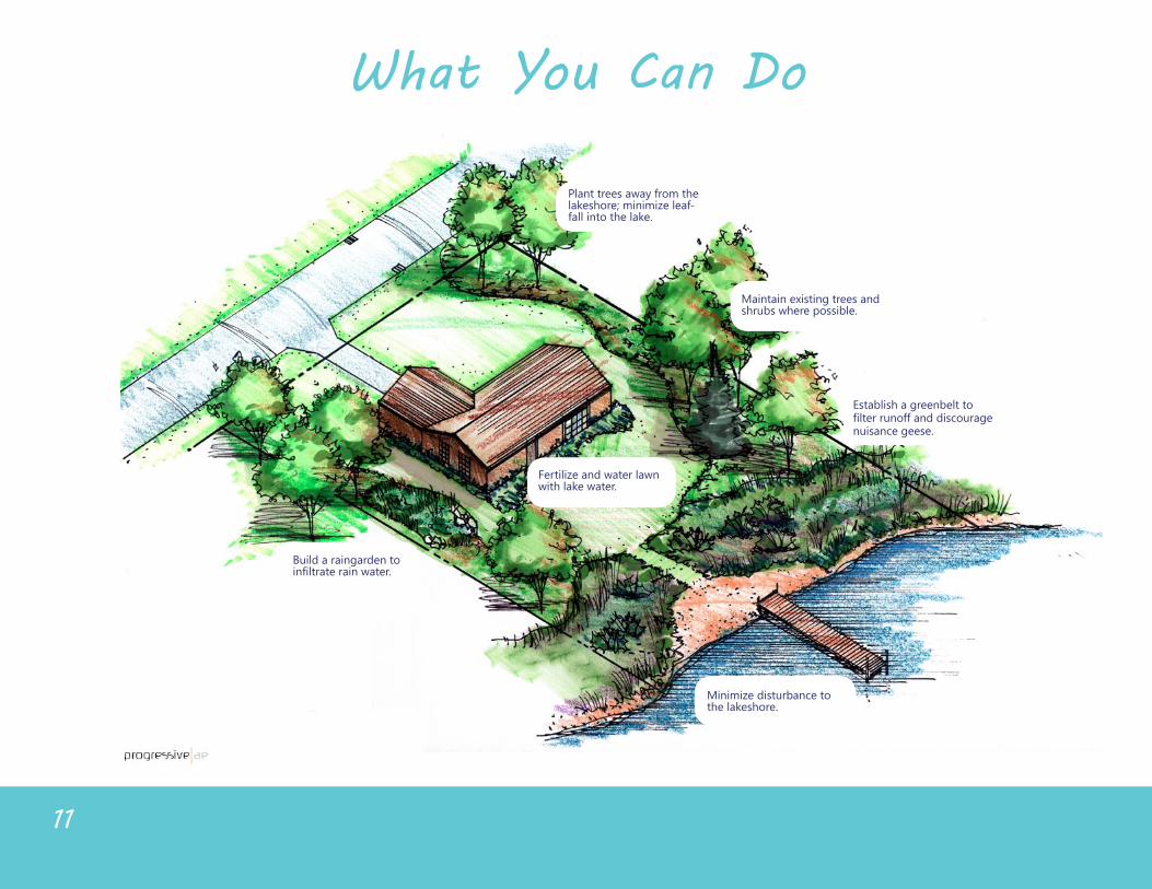
Maintain existing trees and shrubs where possible.
Plant trees away from the
fall into the lake.
Establish a greenbelt to
nuisance geese.
with lake water.
Build a raingarden to
the lakeshore.
What You Can Do
11
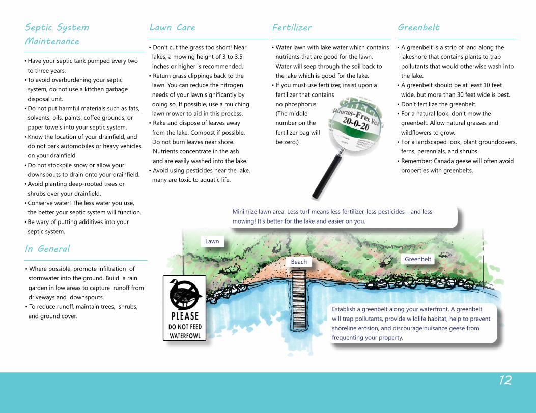
Establish a greenbelt along your waterfront. A greenbelt will trap pollutants, provide wildlife habitat, help to prevent shoreline erosion, and discourage nuisance geese from frequenting your property.
Lawn
Beach Greenbelt
mowing! It’s better for the lake and easier on you.
In General
stormwater into the ground. Build a rain garden in low areas to capture runoff from driveways and downspouts.
and ground cover.
Septic System Maintenance
to three years.
system, do not use a kitchen garbage disposal unit.
solvents, oils, paints, coffee grounds, or paper towels into your septic system.
do not park automobiles or heavy vehicles
the better your septic system will function.
septic system.
Greenbelt
lakeshore that contains plants to trap pollutants that would otherwise wash into the lake.
wide, but more than 30 feet wide is best.
greenbelt. Allow natural grasses and
ferns, perennials, and shrubs.
properties with greenbelts.
Fertilizer
nutrients that are good for the lawn. Water will seep through the soil back to the lake which is good for the lake.
no phosphorus. (﴾The middle number on the
12
Lawn Care
lakes, a mowing height of 3 to 3.5 inches or higher is recommended.
lawn. You can reduce the nitrogen
doing so. If possible, use a mulching lawn mower to aid in this process.
from the lake. Compost if possible. Do not burn leaves near shore.
Nutrients concentrate in the ash and are easily washed into the lake.
many are toxic to aquatic life.
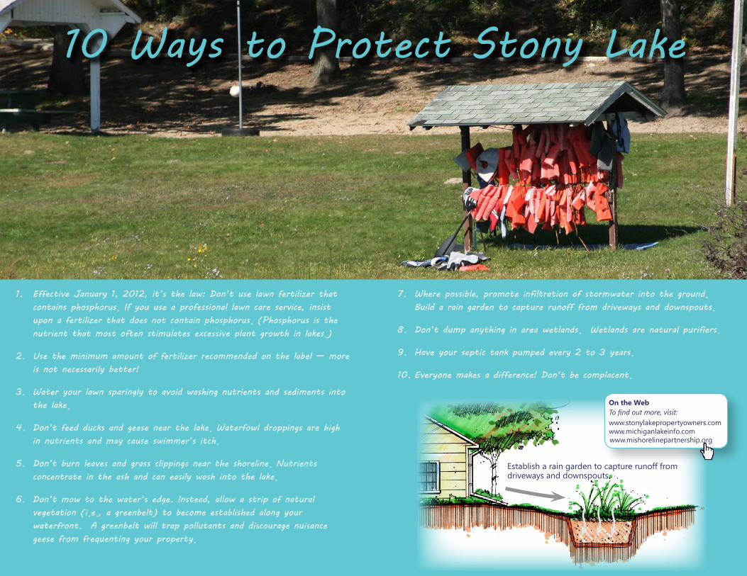
10 Ways to Protect Stony Lake
1. Effective January 1, 2012, it’s the law: Don’t use lawn fertilizer that contains phosphorus. If you use a professional lawn care service, insist upon a fertilizer that does not contain phosphorus. (Phosphorus is the nutrient that most often stimulates excessive plant growth in lakes.)
2. Use the minimum amount of fertilizer recommended on the label — more is not necessarily better!
3. Water your lawn sparingly to avoid washing nutrients and sediments into the lake.
4. Don’t feed ducks and geese near the lake. Waterfowl droppings are high in nutrients and may cause swimmer’s itch.
5. Don’t burn leaves and grass clippings near the shoreline. Nutrients concentrate in the ash and can easily wash into the lake.
6. Don’t mow to the water’s edge. Instead, allow a strip of natural vegetation (i.e., a greenbelt) to become established along your waterfront. A greenbelt will trap pollutants and discourage nuisance geese from frequenting your property.
7. Where possible, promote infiltration of stormwater into the ground. Build a rain garden to capture runoff from driveways and downspouts.
8. Don’t dump anything in area wetlands. Wetlands are natural purifiers.
9. Have your septic tank pumped every 2 to 3 years.
10. Everyone makes a difference! Don’t be complacent.
On the WebTo find out more, visit:www.stonylakepropertyowners.comwww.michiganlakeinfo.com www.mishorelinepartnership.org
Establish a rain garden to capture runoff from driveways and downspouts.