Embed Size (px)
Citation preview

STEPS IN AMOY STREET, WAN CHAI, HONG KONG

1
Contents
1. Background of the Study
2. Research on the Study Area
2.1 Early History of the Study Area
2.2 Amoy Street: Origins and Early Development
3. The Steps in Amoy Street: Preliminary Findings
3.1 Site Observations
3.2 Land Records
4. Findings of Ground Investigations at No. 186 Queen’s Road East
5. Comparison with Swatow Street
6. Conclusions
7. Bibliography
8. Chronology of Events
9. Plates
1 Pottinger’s Map (1842)
2 Gordon’s Map (1843)
3 Lt Collinson’s Ordnance Survey (1845)
4 Plan of Marine Lot 40 (1859)
5 Plan of Marine Lot 40 (1866)
6 Plan of Marine Lot 40 (1889)
7 Plan of Amoy & Swatow Lanes (1901)
8 Plan of Amoy & Swatow Streets (1921)
9 Plan of Amoy & Swatow Streets (1936)
10 Widening of Amoy Street (1949)
11 Surrender of Sec. A of I.L. 4333 (1949)
12 Plan of Amoy & Swatow Streets (1959)
13 Plan of Swatow Street (1938)
14 Plan of Amoy & Swatow Streets (1963)
15 Plan of Amoy & Swatow Streets (1967)

2
1. Background of the Study
1.1 The Urban Renewal Authority (URA) will redevelop the site of Lee Tung
Street and McGregor Street for a comprehensive commercial and residential
development with GIC facilities and public open space. Shophouses at
186-190 Queen’s Road East (Grade II) will be conserved for adaptive re-use.
The Town Planning Board (TPB) at its meeting on 22 May 2007 approved
the Master Layout Plan submitted by URA with conditions including the
submission of a conservation plan for the shophouses to be preserved within
the site to the satisfaction of the Director of Leisure and Cultural Services or
of the TPB.
1.2 Under the redevelopment scheme, a lay-by and turnaround along Amoy
Street (廈門街) is proposed to provide through traffic southbound to
Queen’s Road East, as a result of the closing of Lee Tung Street for
pedestrianization. This would entail the demolition of a set of steps at the
level difference between Amoy Street and Queen’s Road East.
1.3 An assessment of the site, with particular emphasis on the steps in Amoy
Street and Swatow Street and their adjoining areas, has been conducted by
the Antiquities and Monuments Office (AMO) of the Leisure and Cultural
Services Department (LCSD). Archaeological excavation has been
conducted in accordance with existing policy and practice.
Proposed lay-by and turnaround along Amoy Street (as at 16 August 2007)
The steps in
Amoy Street

3
1.4 Photos of the steps in Amoy Street and Swatow Street are on the following
pages.

4
Steps in Amoy Street
Photo 1. Viewing from north to south
Photo 2. Viewing from south to north
Photo 3. Stone tablet “I.L. 4333” Photo 4. Stone tablet “I.L. 4333”
Photo 5. Side view of the Steps Photo 6. Side view of the Steps
The stone
tablet

5
Steps in Swatow Street
Photo 7. Steps in Swatow Street
Photo 8. The flight of six concrete steps
close to Queen’s Road East
Photo 9. The two flights of narrow concrete steps
connected by landings
Photo 10. Part of steps repaired with concrete
Stone
Concrete
Public utilities
manhole cover

6
2. Research on the Study Area
2.1 Early History of the Study Area
2.1.1 The early coastline of Wan Chai (literally, “small bay”) extended from the
west of Morrison Hill to Queen’s Road East around Hung Shing Temple
(also known as Tai Wong Temple), which may have existed as a shrine long
before the British came to Hong Kong Island (Mak et al. 1974, 203). Wan
Chai was developed into a European centre in 1840s to 1850s and has
become an increasingly Chinese residential, labouring and shop-keeping
community by 1860s.
2.1.2 The coastline of Wan Chai underwent considerable changes in the last
century. Several reclamation projects were carried out over the years to
meet the growing demand for land arising from population growth and
economic development. The Praya Reclamation Scheme during 1921-1931
doubled the area of Wan Chai (Hong Kong Legislative Council Sessional
Papers, No.1/1931, 6; Hong Kong Daily Press Office 1940, A-477).
2.1.3 In the early days numerous sampans gathered along the shoreline near the
Hung Shing Temple which was a landmark seen from the water. Local
fishermen and boat builders plied their trade here, and later the British built
shipyards, piers (Burns’ Pier and Larkin’s Pier) and godowns. Shops such
as ships’ chandlers and other maritime trades were set up (Wordie 2002, 102;
Er 2003, 185-186). This association with the sea is still remembered today
in street names such as Ship Street (船街), Schooner Street (捷船街) and
Sam Pan Street (三板街).
2.1.4 The area now known as Wan Chai was developed into a European
commercial and residential centre after the arrival of the British in 1841.
Queen’s Road East, one of the oldest roads along the oldest northern shore
of Wan Chai, was built in 1840s to become the main thoroughfare of the
British settlement (Eitel 1983, 185).

7
2.2 Amoy Street: Origins and Early Development
2.2.1 The British arrived at Hong Kong in January 1841 and the first land sales, by
public auction, took place on 14 June. Thirty marine lots were then ready
for sale, each having a frontage along Queen’s Road, and varying in depth to
the shore according to the shape of the coastline (Endacott 1973, 28; Eitel
1983, 172-173).
2.2.2 Amoy Street was opened up on Marine Lot 40 (M.L. 40), north of Queen’s
Road East (Hong Kong Administrative Report 1915, Q-23). According to
British colonial records, M.L. 40 measured 6,000 square feet. Its first
purchaser was MacVicar & Co. which used the lot as warehouse and paid an
annual rent of £75 to the Hong Kong government (Ho 2004, 29).
2.2.3 M.L. 40 passed in succession through the hands of several owners. Since
the 1840s, this site (then being the sea front) was once occupied by a pier
named Burn’s Pier, probably named after leading British merchant and
Justice of the Peace, D.L. Burn (Eitel 1983, 159). Later on, it became a
property of Dr Patrick Manson (founder of Dairy Farm) who came to Hong
Kong in 1883 from Amoy where he had been serving as a medical officer in
the Chinese Maritime Customs, as well as the site of sugar factories, etc.
(Crisswell 1979; Smith 1995, 125).
2.2.2 Amoy Street originally was called Amoy Lane. By 1915, Amoy Lane was
a private lane as well as ‘cul-de-sac’ (i.e. a short road which is closed at one
end by houses or by a barrier of some kind) opening off Queen’s Road East,
its northern ends being blocked by godowns which occupied the northern
portion of M.L. 40 (Hong Kong Administrative Report 1915, Q-59).
2.2.3 In 1914/15, the owner of the godowns having decided to erect houses on his
lot, it became necessary for him to lay out streets. Accordingly, Amoy
Lane was extended through the rest of the lot (M.L. 40) to the Praya East
(the present Johnston Road). Forming, surfacing, kerbing, channeling and
paving extensions (30 feet wide) were done in 1915. In view of the altered
conditions, the ‘lane’ was renamed ‘street’ (Hong Kong Government Gazette,
25 June 1915, 325; Hong Kong Hansard 24 June 1915, 46).

8
2.2.4 In 1916, re-surfacing and other repairs under the provisions of Section 186
of the Buildings Ordinance were carried out by the Public Works
Department at the cost of the frontagers in Amoy Street and Swatow Street
(Hong Kong Administrative Report 1916, Q-17).
2.2.5 In 1923 and 1926, storm-water drains and sewers were laid at Amoy Street,
as part of the Praya East Reclamation Scheme which necessitated not only
the raising of certain roads with all sewers and storm-water drains but also
the ground floor levels of some of the old houses. This was necessary in
order to provide satisfactory gradients and outfalls for the discharge of storm
water and sewers on the line of the new sea wall (Hong Kong Administrative
Report 1923, Q-102; 1926, Q-81; Hong Kong Legislative Council Sessional
Papers, No.1/1931, 1).
3. The Steps in Amoy Street: Preliminary Findings
3.1 Site Observations
3.1.1 The existing seven steps of Amoy Street (the Steps) are built of modern
concrete, flanked by two modern railings at each side. They are ordinary
steps with no architectural merits.
3.1.2 Traces on the Steps indicate that half of the Steps have been altered recently.
An old-time resident, who has been living in Wan Chai since 1956 and
working in Amoy Street for some 20 years, recalled that the Steps have been
repaired in recent years, and that there were no railings on the Steps in the
past (Kwan Yau-fen pers. comm.).
3.1.3 From evidence in other places the original steps were probably granite slabs.
The present concrete steps show a distinct joint in the centre probably
because the steps were built in two halves so as not to disrupt pedestrian
access to and fro (Photo 11).

9
3.1.4 The platform at the junction of Amoy Street and Queen’s Road East is paved
by red bricks, and the area close to the Steps (about 3 x 7 m) has more than
twelve marks of public service utilities, e.g., electricity, drainage, gas,
drinkable water and tele-communication, which pipe works are probably laid
underneath, so the area has been disturbed.
3.1.5 The possibility of discovery of original stone steps is relatively low, while
road blockage and suspension of relevant public service utilities (which are
not practicable) are required for conducting archaeological excavation. In
view of the above, ground investigations are conducted at the vacant
pre-Second World War building in No.186 Queen’s Road East nearby.
3.2 Land Records
3.2.1 Maps of early Hong Kong (e.g. Pottinger’s Map of 1842, Gordon’s Map of
1843, Lt Collinson’s Ordnance Survey of 1845, as well as a map of 1859)
indicate that Amoy Street falls on Marine Lot 40 (M.L. 40) which adjoined
the early coastline of Victoria Harbour (Plates 1 to 3).
3.2.2 From the early days of the British settlement, the lots of land had all fronted
on Queen’s Road East and the marine lot holders had been left to provide
piers or effect any improvements on the sea fronts they chose (Endacott
1973, 101). Queen’s Road ran parallel to the sea through this area.
Photo 11. The joint at the centre of the Steps in Amoy Street
The joint

10
3.2.3 The early maps also show that the existing steps in Amoy Street, which falls
on M.L. 40, are geographically close to the early coastline of Old Wan Chai
where a pier, namely, Burn’s Pier, was constructed.
3.2.4 By 1866 (1859 to 1866), Praya East (the present Johnston Road) was built to
the north of M.L. 40. The praya involved the construction of a sea wall and
a measure of reclamation since it could not follow the uneven coastline
(Plates 4 to 6).
3.2.5 According to a 1901 map (Plate 7), Amoy Street (formerly Amoy Lane) was
assigned a house number 158 and it might not be opening off Queen’s Road
East up to 1901. Also, the map does not indicate any steps in Amoy Lane.
On the other hand, many steps in other parts of Wan Chai (such as those in
Ship Street and Tik Lung Lane) are shown in the same map.
3.2.6 A 1921 map (Plate 8) indicates that Queen’s Road East and Amoy Street and
Johnston Road might be accessed through before 1921; however, no steps in
Amoy Street are indicated. Once again, many steps in other parts of Wan
Chai (including the small ones in Tik Lung Lane) are shown in the same
map.
3.2.7 According to another old map dated 1936 (Plate 9), there is no evidence that
the existing steps in Amoy Street were built before World War II.
3.2.8 The steps in Amoy Street were shown in a drawing of the then Public Works
Department dated 21 January 1949 (Plate 10). At the time, the government
intended to acquire land for road widening.
3.2.9 The steps in Amoy Street were shown in another drawing dated 28 July 1949
(Plate 11). At the time, a parcel of land of Inland Lot 4333 (I.L. 4333)
required for the widening of Amoy Street was surrendered to the government.
Nowadays, a stone tablet engraved “I.L. 4333” still exists on site.
3.2.10 A comparison of the land records of 1949 (aforesaid) and maps of a later
year such as those of 1959 (Plate 12) indicates that the existing steps in
Amoy Street appear to be identical in size and location during the past half
century or so.

11
4. Findings of Ground Investigations at No. 186 Queen’s Road East
4.1 Ground investigations in the form of excavation and visual inspection have
been conducted by a consultant of the Urban Renewal Authority (URA) in
order to obtain informed data underneath the building at No. 186 Queen’s
Road East, which is adjacent to the existing steps in Amoy Street. In
addition, the Antiquities and Monuments Office (AMO) conducted manual
augering at one of the trial pits for further information.
4.2 In the first place, four trial pits were excavated by URA’s consultant at No.
186 Queen’s Road East. The findings revealed that the building
foundations are 2 metre below ground level resting on a loose to medium
compact fill or coarse sand and gravel. In one of the trial pits at the rear of
the building, the top 1.8 metre was imported backfill material and sand was
found below 1.8 m. It is not known if the sand is natural marine sand (The
Team Consultant 2007, 3).
4.3 An additional (fifth) trial pit within the building was excavated by URA’s
consultant on 24 September 2007. The excavation ceased at the depth of
1.5 metre below the existing surface due to site safety. Section of this trial
pit showed no soil change below the surface, i.e., dark grey sandy soil mixed
with gravels and tile fragments.
4.4 Further to the excavation of URA’s consultant, AMO conducted manual
augering at the bottom of the fifth trial pit. Augering ceased at 2.6 metre
below the existing surface due to underground water (water level at -2.2
metre). Fill materials were found at approximately -1.5 metre to -2.15
metre, and a layer of light brown loose coarse sand was found at
approximately -2.3 metre to -2.6 metre.
4.5 Based on the above findings, it is highly likely that the steps of Amoy Street
were laid on backfill materials. The possibility that the light brown loose
coarse sand is original marine sand could not be completely ruled out;
however, the above findings give no direct evidence to confirm that the steps
of Amoy Street are markers of the first coastline before 1842.

12
5. Comparison with Swatow Street
5.1 Amoy Street and Swatow Street (one street to the west of Amoy Street) were
both situated in M.L. 40. They appeared as “lanes” in the 1910 map (Plate
8) and became streets in 1915 when they were extended through M.L. 40 to
the Praya East (Hong Kong Administrative Report 1915, Q-59).
5.2 Presently, there is a flight of six concrete steps built on Swatow Street close
to Queen’s Road East, and two wide granite steps located in the close
proximity of the concrete steps (1/3 were damaged).
5.3 Alongside these steps in Swatow Street there are two further flights of
concrete steps about 1 metre wide connected by landings, with a public
utilities manhole cover inscribed “HGC BROADBAND” set in the middle
landing.
5.4 The forms and sizes of the existing steps at Amoy Street and Swatow Street
are different. They were not aligned on the same line, and situated at two
different levels.
5.5 According to a drawing of the Superintendent of Crown Lands & Survey for
1938 (Plate 13), there is no evidence that the existing concrete steps in
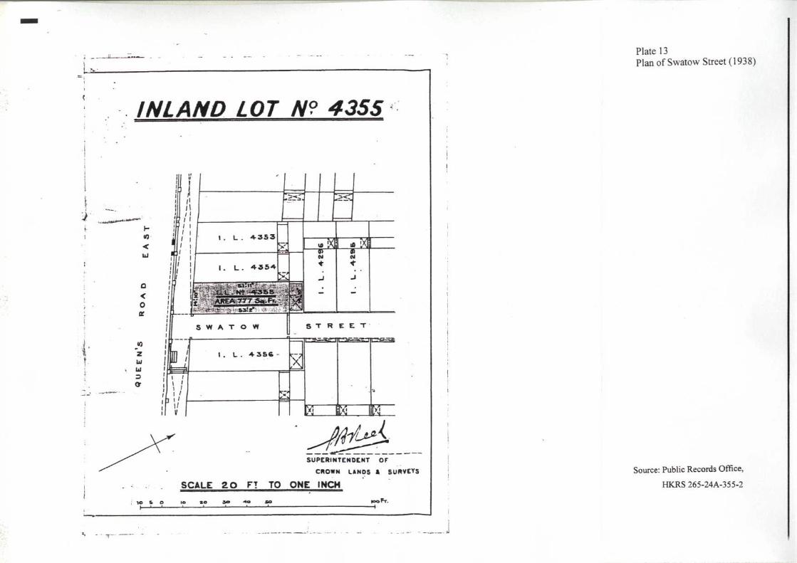
Swatow Street were built before World War II. The two levels of granite
steps, however, have probably existed by 1938.
5.6 In a 1949 drawing of the Public Works Department (Plate 10, aforesaid),
there is an indication that the two levels of granite steps in Swatow Street
probably existed in 1949. There is, however, no indication that the existing
concrete steps in Swatow Street were built before that time.
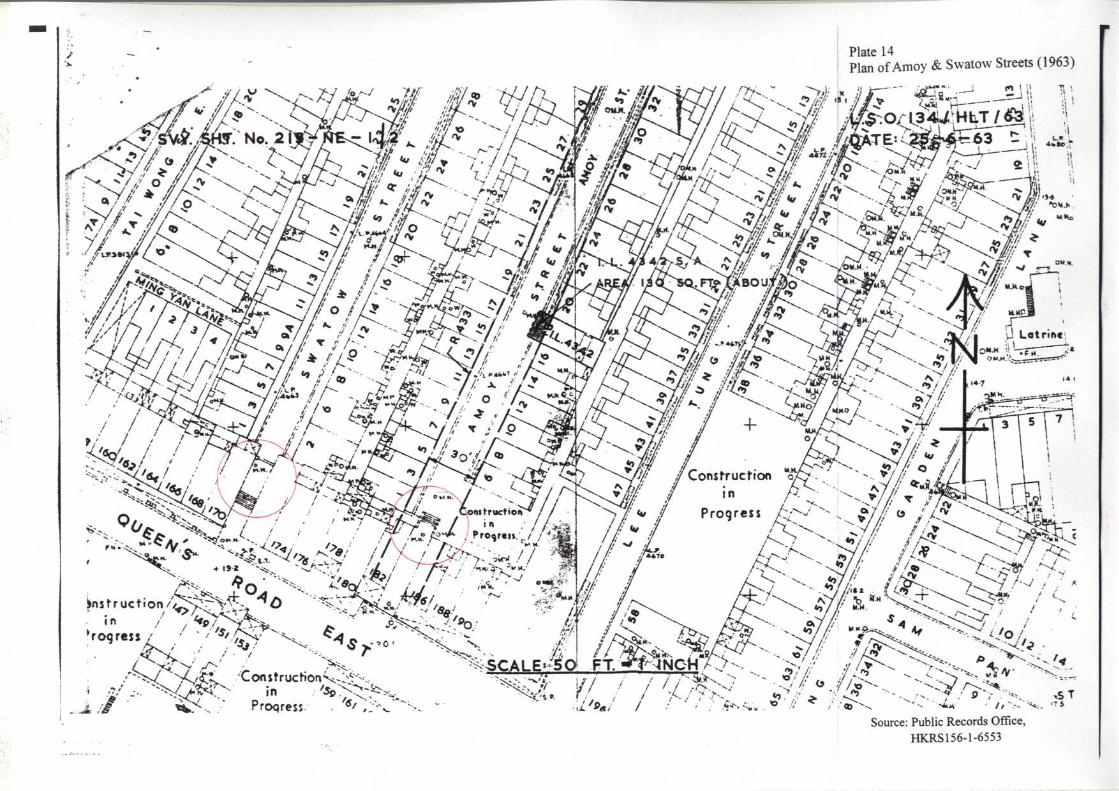
5.7 A comparison of Plate 10 (dated 1949), Plate 14 (dated 1963) and Plate 15
(dated 1967) shows that the two flights of narrow concrete steps connected
by landings in Swatow Street were probably built between 1963 and 1967,
when a portion of Inland Lot 4356 (I.L. 4356) was resumed for the purpose
of road widening.

13
6. Conclusions
6.1 Amoy Street and Swatow Street were opened up on part of Marine Lot 40
(M.L. 40) which marked where the coastline of Wan Chai was at the time
when the British arrived at Hong Kong Island in 1841.
6.2 It is possible that the level differences between Queen’s Road East and
Amoy Street / Queen’s Road East and Swatow Street are indicative of the
early landform of the old seashore of Wan Chai. But there is also evidence
that the difference in level was brought about by the raising of road levels,
storm-water drains and sewers as part of the Praya East Reclamation Scheme
completed in 1930.
6.3 Government land records show no evidence of the existence of the present
Amoy Street steps before the Second World War. There is, however, clear
evidence that such steps existed in 1949.
6.4 The six concrete steps built on Swatow Street close to Queen’s Road East
are shown in a map for 1959, whilst the two levels of granite steps located in
the close proximity of the concrete steps probably existed in 1938. The
two narrow flights of steps connected by landings appear to have been built
between 1963 and 1967 after resumption of a portion of I.L. 4356.

14
7. Bibliography
Official Reports and Documents
Hong Kong Administrative Report. 1915, 1916, 1923, 1926. Hong Kong: Noronha &
Co.
Hong Kong Government Gazette. 1915. Hong Kong: Noronha & Co.
Hong Kong Hansard, Printed Proceedings of the Legislative Council. 1915. Hong
Kong: Noronha & Co.
Hong Kong Legislative Council Sessional Papers. 1931. Hong Kong: Noronha & Co.
Archives in Public Records Office, Hong Kong
HKRS 156-1-6553. Amoy Street, Hong Kong – Acquisition of Land for the
Widening of … (24.06.1958 – 16.08.1963)
HKRS 156-2-3248. Swatow Street, Hong Kong – Acquisition of Land for the
Widening of … (14.08.1967)
HKRS 265-11A-3059. I.L. No. 4333, S.A. – Deed of Surrender of Section A of
Inland Lot No. 4333 (09.04.1952)
HKRS 265-11D-3133-1. Praya East Reclamation L. No. 40; Praya East Reclamation
L. No. 40, S.A; Praya East Reclamation L. No.43, S.A- Agreement (23.11.1921)
HKRS 265-24A-355-2. I.L. 4355 – Crown Lease of Inland Lot No. 4355
(23.03.1938)
Archives in Survey and Mapping Office, Hong Kong
HD 32. Plan of Marine Lot 40 (1866)
HG 20-1. Plan of Marine Lot 40 (1850)
HG 28-5. Plan of Marine Lot 40 (1889)
HG 34-4. Plan of Amoy & Swatow Streets (1936)
HG 35-2. Plan of Marine Lot 40 (1859)
HH 19. Plan of Amoy & Swatow Lanes (1901)
Sheet No. 213-NE-1 (1959). Plan of Amoy & Swatow Streets (1959)
Sheet No. 213-NE-1 (1967). Plan of Amoy & Swatow Streets (1967)
Books, Monographs and Articles
Cheng, Po-hung (2001) A Century of Hong Kong Island Roads and Streets. Trans.
Paul Levine and Judy Chang. Hong Kong: Joint Pub. (Hong Kong) Co.
Crisswell, Colin (1979) ‘The Vanishing City: Poor Business in Wanchai,’ South
China Morning Post (Hong Kong), 7 January.

15
Eitel, E.J. (1983) Europe in China. Reprint of the 1895 original with the addition of
an introduction by H.J. Lethbridge. Hong Kong: Oxford University Press.
Empson, Hal (1992) Mapping Hong Kong: A Historical Atlas. Hong Kong: Hong
Kong Government Printer.
Endacott, G.B. (1973) A History of Hong Kong. Revised edition. Hong Kong: Oxford
University Press.
Er, Tong (爾東) (2004) Qutan Xianggang jiedao 趣談香港街道 (Gossip on Hong
Kong streets). Hong Kong: Ming Pao Publication Ltd.
Ho, Pui-yin (2004) Challenges for an Evolving City: 160 years of Port and Land
Development in Hong Kong. Trans. C.S. Johnson. Hong Kong: Commercial Press.
Hong Kong Daily Press Office (1940) The Directory and Chronicle of China, Japan,
Corea, Indo-China, Straits Settlements, Malay States, Siam, Netherlands India,
Borneo, The Philippines & C. Hong Kong: Hong Kong Daily Press Office.
Mak, K.Y., Mackreth, A.H., Liu, B. and Werle, H. (1974) ‘Programme Notes for Visits
to Older Parts of Hong Kong Island (Urban Areas), and to Kowloon, in 1974,’
Journal of the Hong Kong Branch of the Royal Asiatic Society, 14: 196-234.
Smith, Carl T. (1995) A Sense of History: Studies in the Social and Urban History of
Hong Kong. Hong Kong: Hong Kong Educational Publishing Co.
The Team Consultant (2007) ‘Brief Description on the Steps at the Junction of Both
Swatow Street and Amoy Street with Queen’s Road East.’ Unpublished report
prepared in association with Urban Renewal Authority.
Wordie, Jason (2002) Streets: Exploring Hong Kong Island. Hong Kong: Hong
Kong University Press.
Oral Interviews
Kwan Yau-fen (關友芬). October 8, 2007. Interviewer: Fung Chi-ming. Mr. Kwan
is a staff of Kwan King Kee Machinery Engineering (關敬記機器工程), No.27
Amoy Street, Wan Chai, Hong Kong.

16
8. Chronology of Events
Year
Event Source
1842 Burn’s Pier at M.L. 40 projecting from
shoreline.
Pottinger’s Map (1842)
1843 Extension of the shoreline at M.L. 40
toward the harbour.
Gordon’s Map (1843)
1845 � The shoreline at the section of M.L. 40
was situated at about 200 feet north of
Queen’s Road East.
� The structure building on M.L.40 is
behind the coast.
Lt
Collinson’s Ordinance
Survey (1845)
1850 Further extension of the coastline of M.L.
40 toward the harbour.
Plan of Marine Lot 40, 1859
and 1866
1859-66 Extension of the shoreline to the present
Johnston Road (formerly, Praya East)
Plan of Marine Lot 40, 1859
and 1866
1862 Procurator of the Dominican Mission
bought M.L. 40 as an investment.
Smith (1995, 125)
1868-69 The building on M.L. 40 was rented to the
military.
Smith (1995, 125)
1876 Oriental Sugar Co. (太古糖廠) commenced
business on M.L. 40 and closed down after
a few years.
Crisswell (1979)
1888 Jardine, Matheson & Co. purchased M.L.
40 and changed the name of the factory as
China Sugar Refinery (中國煉煻廠).
Smith (1995, 125)

17
Year
Event Source
1889 (after) The land was redeveloped with Chinese
houses after the pull down of the refinery in
1889.
Smith (1995, 125)
1912 The government demolished the riding
floors over the entrance to Amoy Lane for
the provision of scavenging lanes.
Hong Kong Administrative
Report 1912, 20
1915 Amoy Lane and Swatow Lanes were
renamed ‘streets’ and, by arrangement with
the leasee, the new portions were taken
over as public streets.
Hong Kong Government
Gazette, 25 June 1915, 325
1916 Re-surfacing and other repairs to Amoy
Street and Swatow Street.
Hong Kong Administrative
Report 1916, Q-17
1923, 1926 Storm-water drains and sewers were laid at
Amoy Street.
Hong Kong Administrative
Report 1923, Q-102; 1926,
Q-81.
1921-30 Praya East Reclamation Scheme. The
coastline was extended to Gloucester Road.
Cheng (2001, 70)
1949 Widening of Amoy Street and Swatow
Street.
Public Records Office,
HKRS 265-11A-3059
1963-67 The two flights of narrow concrete steps
connected by landings in Swatow Street
were built.
Public Records Office,
HKRS 156-1-6553
Survey and Mapping Office,
Sheet No. 213-NE-1 (1967)