Embed Size (px)
Citation preview
137
Steelhead/rainbow trout resources of Monterey County
Salinas River
The Salinas River consists of more than 75 stream miles and drains a watershed of about 4,780 square miles. The river flows
northwest from headwaters on the north side of Garcia Mountain to its mouth near the town of Marina.
A stone and concrete dam is located about 8.5 miles downstream from the Salinas Dam. It is approximately 14 feet high and is
considered a total passage barrier (Hill pers. comm.). The dam forming Santa Margarita Lake is located at stream mile 154 and
was constructed in 1941. The Salinas Dam is operated under an agreement requiring that a “live stream” be maintained in the
Salinas River from the dam continuously to the confluence of the Salinas and Nacimiento rivers. When a “live stream” cannot
be maintained, operators are to release the amount of the reservoir inflow. At times, there is insufficient inflow to ensure a “live
stream” to the Nacimiento River (Biskner and Gallagher 1995).
In addition, two of the three largest tributaries of the Salinas River have large water storage projects. Releases are made from both
the San Antonio and Nacimiento reservoirs that contribute to flows in the Salinas River. Operations are described in an appendix
to a 2001 EIR:
“ During periods when…natural flow in the Salinas River reaches the north end of the valley, releases are cut back to
minimum levels to maximize storage. Minimum releases of 25 cfs are required by agreement with CDFG and flows
generally range from 25-25[sic] cfs during the minimum release phase of operations. If flow is low in the Salinas River
and no flow reaches the north end of the valley, conservation releases are made to bring end of flow downstream to
about Spreckels. Conservation releases during the winter steelhead spawning period are typically around 300 cfs…”
(Needham and Taft 1934).
Staff from DFG met in 1959 to discuss fisheries of the Salinas River watershed. Notes from the meeting indicate the position of
DFG at the time, notably that “in wet years there is a rudimentary [steelhead] run” and “primary areas for fish life are…sections
up to 5-10 miles below dams, e.g. below Nacimiento, because of lower water temperatures and spawning areas which will be
scoured out by releases; this to be a trout fishery…” (DFG 1959a). Additionally, the notes state, “We do not see any fishery values
in the main Salinas River…” (DFG 1959a).
The Salinas River upstream of Santa Margarita Lake was surveyed by DFG in 1961. The survey report states, “Success of fishes is
nil due to lack of water” (DFG 1961a).
Field notes by DFG staff from 1963 summarized the Salinas system thusly:
“ The historical background of the anadromous fish runs in the Salinas River is basically as follows. In the historical
past, the river did support a fair steelhead run. It was probably largely supported by spawning and nursery areas in the
upper main river, Nacimiento, San Antonio and Arroyo Seco rivers. The water development projects in the drainage
have gradually reduced these steelhead runs, probably due mainly to the reduction of available spawning and nursery

138
areas. The Salinas Dam cut off the upper main river area. The Nacimiento River dam further reduced this. The San
Antonio Dam will eliminate any runs remaining in that tributary. The Arroyo Seco River only will remain. Water
development will no doubt reduce the availability of water from this tributary. This results in insufficient spawning and
nursery areas remaining in the drainage to support any sizeable run. Also, it can be anticipated in the future that there
will be very little runoff to the ocean in future years, except in wet years when the dams spill. With the construction of
the Nacimiento and San Antonio Dams, an endeavor will be made to store the winter runoff and percolate it into the
underground basin. There will therefore be an attempt to prevent loss of water to the ocean. There will still be water
reaching the ocean on wet years. For percolation purposes, the entire channel of the Salinas River will be utilized to a
point opposite Spreckels, which is 16 miles above the ocean.
It can be concluded that the utilization of the Salinas River by anadromous fishes is largely a thing of the past. This is based upon
(1) winter runoff of water to the ocean will not be sufficient to attract steelhead runs and permit them to enter from the ocean,
(2) adequate spawning and nursery areas are no longer present, (3) conditions in the Salinas River proper are not suitable for the
development of anadromous fishes” (DFG 1963a).
As part of the 1965 state fish and wildlife plan, DFG prepared an inventory of anadromous salmonids. According to the
inventory, about 404 mile of steelhead habitat, “much of which is of very poor quality,” exists in the Salinas River system. At the
time of the inventory the Salinas steelhead run was estimated to consist of about 500 individuals. The plan states, “The most
critical factors are the lack of water and the need to develop what water there is for agriculture” (DFG 1965a, p. 398)
In a 1994 report Jerry Smith states about the Salinas River system:
“ …surface flow reaches the mouth only during the winter and during the spring of wet years. Spring passage flows for
steelhead smolts are not required and rarely occur. Steelhead rearing habitat is probably extensive and is also probably
present in most years in the three tributaries, but can seldom be used because of the poor migration conditions” (Smith
1994).
The report also notes that Salinas River steelhead may be of “mixed genetic origin” due to poor conditions for steelhead
production in the watershed and the stocking of steelhead by the Monterey Bay Salmon and Steelhead Trout Project (Smith
1994). An anecdotal account of steelhead in the Salinas near Atascadero in the winter of 1995 was reported by DFG staff (DFG
1999a).
A 2001 report included discussion of the “Upper Salinas”, which was defined as the 14-mile reach downstream from Santa
Margarita Lake. The report summarized steelhead resources of the watershed as follows:
“ There is some suitable habitat for steelhead in the Upper Salinas Basin and possibly remnant steelhead populations.
However, habitat in the Upper Salinas is of lower quality and is less extensive than that in the Arroyo Seco and its
tributaries…The Upper Salinas is also less accessible for steelhead than the Arroyo Seco” (EDAW 2001).
139
In a 2001 memorandum, DFG staff recommended the following:
“ Information on the flow releases from Nacimiento, San Antonio and the Salinas Dam needs to be compiled or obtained
in order to determine if flow in the Salinas River is sufficient to allow upstream passage of adult steelhead from late
November through April and downstream passage of juveniles from December through May.
Concurrent with obtaining the flow data, select channel measurements of the Salinas River need to be made in order to calculate
the flow needed to provide a minimum of 10 to 12 inches depth” (DFG 2001b).
The Salinas River lagoon is managed by sandbar breaching “when flow in the Salinas River is predicted to be sufficiently high to
cause an increase in lagoon stage that threatens to flood adjacent agricultural lands” (HES 2004, p. 2). The lagoon was monitored
during 2003-2005 in association with the lagoon breaching program, and steelhead were not observed. A resulting report notes
that the absence of rearing juvenile steelhead in the lagoon “…is consistent with results of previous surveys going back to 1990”
(HES 2004, p. 1).
As part of the Salinas Valley Water Project, an inflatable dam is planned for construction on the Salinas River at about river
mile 4.0. The project will include a fishway and a steelhead population and habitat monitoring program, and has been tied to
re-operation of the Nacimiento and San Antonio rivers reservoirs to facilitate steelhead passage (NMFS 2007). The Biological
Opinion for the project identified an “Upper Salinas” O. mykiss population consisting of resident rainbow trout that “co-occur”
with steelhead.
Gabilan Creek
In a 1960 memo, Gabilan Creek was called tributary to Tembladero Slough. It drains to Elkhorn Slough via the Old Salinas River
channel. The creek consists of about 19.3 stream miles flowing overall southwest from headwaters in Fremont Peak State Park.
The lower reaches are referred to as the Reclamation Ditch.
A 1959 survey report notes that steelhead spawning could occur in upper Gabilan Creek during wet years (DFG 1959b). Resident
rainbow trout, likely descended from planted O. mykiss was said to be “fairly successful” in the creek (DFG 1959b). In a 1960
memo DFG states, “…Gabilan Creek…supports a small trout fishery. It is not known whether the existent trout fishery involves
young steelhead or resident rainbow” (DFG 1960a).
Gabilan Creek was surveyed in 2000. The survey found multiple age classes of steelhead (DFG 2000a). An adult steelhead was
collected from Gabilan Creek in 2004 (DFG 2004).
Natividad
Natividad Creek consists of about seven stream miles and is tributary to Gabilan Creek. It flows southwest, entering Gabilan
Creek in the city of Salinas.
A 2002 DFG letter states, “Natividad Creek is known as a migration route for steelhead trout” (DFG 2002). The basis for the
statement is not provided.

140
Pilarcitos Canyon
Pilarcitos Canyon Creek consists of about 4.8 stream miles and is tributary to the Salinas River. It flows northwest, entering the
Salinas at about stream mile 11.
Pilarcitos Canyon Creek appears on an undated list of Monterey County streams with historical steelhead populations. The basis
for inclusion is not provided.
El Toro
El Toro Creek consists of more than 16 stream miles and is tributary to the Salinas River. It flows east from headwaters at Mt.
Toro through Calera Canyon, then north to its confluence with the Salinas at about stream mile 12.
As part of a steelhead range contraction study, NMFS staff visited El Toro Creek 2003. It was found to be dry and therefore not
capable of supporting O. mykiss (NMFS 2005).
Watson
Watson Creek consists of about 6.5 stream miles and is tributary to El Toro Creek. It flows west through the Corral de Tierra
Valley.
Watson Creek appears on an undated list of Monterey County streams with historical steelhead populations. The basis for
inclusion is not provided.
Limekiln
Limekiln Creek consists of about five stream miles and is tributary to the Salinas River. It flows east to its confluence with the
Salinas west of the town of Gonzalez.
Limekiln Creek appears on an undated list of Monterey County streams with historical steelhead populations. The basis for
inclusion is not provided.
Arroyo Seco
Arroyo Seco is one of the three main tributaries of the Salinas River. It flows east from the Santa Lucia range and has its
confluence with the Salinas River near Greenfield. It consists of about 37 stream miles and has a watershed of about 303 square
miles. A fishway is located at the Thorne Road crossing at about stream mile 7.5. Various problems with passing fish at this
location have led to a planned road crossing replacement that is expected in 2008 (Hill pers. comm.). Several reports note that
flows in the lower ten miles of the Arroyo Seco go “underground most years” (DFG 1957a; Bianchi and Miller 1994).
141
A 1948 DFG letter characterized the typical steelhead run in the Arroyo Seco as “heavy” (DFG 1948a). A 1957 DFG survey
report calls the upper Arroyo Seco “an excellent stream with good year round flow but with a definitely limited capacity” (DFG
1957a).
In a letter in 1986 DFG stated, “Steelhead have returned to the Arroyo Seco River eight of the last ten year” (DFG 1986). The
lack of a run during the other two years was ascribed to the bar at the mouth not being breached due to drought. A 1992 DFG
memo noted, “…no steelhead have gone through the [Thorne Road] ladder between 1987 and 1992” (DFG 1992a). Staff from
DFG believed that insufficient Arroyo Seco flows existed to reach the Salinas River confluence.
Surveys of five streams were conducted in 1992 by DFG to inform management, including about four miles of the Arroyo Seco.
In the survey report, O. mykiss population density was estimated to be 362 individuals per mile, which was characterized as “poor”
(DFG 1993a). The survey report states, “Two possible factors for the low estimated trout population are the lack of stream flow
(measured in August at 0.3 cfs) and suitable spawning substrate” (DFG 1993a). A 1994 report by a consulting firm examined
passage flows in the Arroyo Seco and documented steelhead migration and spawning. The surveys “revealed areas of excellent
trout habitat” largely inaccessible to steelhead due to insufficient inmigration flows (Bianchi and Miller 1994).
In 1999, NMFS stated that the recommended “long-term fix for [the Thorne Road Crossing] migration barrier would be to
replace the low-flow crossing with a bridge or a series of short-span structures…[that] would eliminate the need for the fish ladder
and allow passage at all flows through a natural stream channel” (NMFS 1999). Staff from USFS surveyed Arroyo Seco in 1999
and 2000 and observed multiple O. mykiss year classes (USFS 1999a).
Arroyo Seco was surveyed as part of a Salinas River system fish distribution study in 2001. Multiple O. mykiss year classes were
observed between Government Camp and the Willow Creek confluence. The resulting report states, “Today the best remaining
habitat [in the Salinas River system] for anadromous salmonids is in the Arroyo Seco Watershed” (Casagrande 2003, p. 48). A
biological opinion prepared for a water supply project on the Salinas River states, “[T]he Arroyo Seco River is the most important
remaining steelhead habitat in the Salinas River watershed” (NMFS 2007, p. 65). Staff from DFG recovered the carcass of an
adult steelhead (about 28 inches in length) at the Thorne Road crossing in August 2008 (Highland pers. comm.).
Reliz
Reliz Creek consists of about 16.5 stream miles and is tributary to Arroyo Seco. It flows north, entering Arroyo Seco west of the
town of Greenfield.
In a 1969 document, Reliz Creek is listed as having “spawning and nursery areas” for steelhead (SWRCB 1969).
Vaqueros
Vaqueros Creek consists of about eight stream miles and is tributary to Arroyo Seco. The confluence is downstream from
Sycamore Flat.

142
Trout were noted in winter 1993-1994 by consulting biologists surveying Vaqueros Creek (Bianchi and Miller 1994). As part of
a study of steelhead in the Salinas River, Vaqueros Creek was surveyed again in 1996. The biologists observed “resident rainbow
trout” in Vaqueros Creek during the surveys (HES 1996).
As part of a fish distribution study published in 2002, historical accounts of steelhead observations were reviewed and described.
The resulting report notes an observation of several steelhead in Vaqueros Creek in 1998 (Casagrande 2003).
Sweetwater
Sweetwater Creek consists of about 5.1 stream miles and is tributary to Arroyo Seco. The confluence is downstream from
Sycamore Flat.
No fish were observed in a winter 1993-1994 survey of Sweetwater Creek by consulting biologists (Bianchi and Miller 1994).
Horse
Horse Creek consists of about 7.2 stream miles and is tributary to Arroyo Seco. The confluence is upstream from Sycamore Flat.
The creek is referred to as Horse Canyon Creek in reports.
In 1936, DFG stocked Brookdale Hatchery steelhead in Horse Canyon Creek (DFG 1938).
Piney
Piney Creek consists of about ten stream miles and is tributary to Arroyo Seco. It enters the arroyo from the north downstream
from Millers Ranch.
In a 1992 memo DFG states that Piney Creek “supports a spawning population of trout in good water years” (DFG 1992a).
Several surveys between 1994 and 2001 by consultants and staff from the U.S. Forest Service and NFMS found O. mykiss in
Piney Creek (Bianchi and Miller 1994; Chubb 1997; NMFS 2003a). As part of a fish distribution study published in 2002,
historical accounts of steelhead observations were reviewed and described. The resulting report notes an observation of up to 50
steelhead “throughout the winter in a pool on Piney Creek” in the mid to late 1990s (Casagrande 2003). The context for the
observation suggests that the individuals were adult in-migrants.
Rocky
Rocky Creek consists of about 4.2 stream miles and is tributary to Arroyo Seco. It flows southeast, entering Arroyo Seco upstream
from the Arroyo Seco Station.
A 1948 DFG letter states that Rocky Creek is not accessible to steelhead because of a natural falls at the confluence (DFG 1948b).
143
Santa Lucia
Santa Lucia Creek consists of about ten stream miles and is tributary to Arroyo Seco. It flows northwest, entering Arroyo Seco
upstream from The Lakes Campground.
A 1945 DFG survey of Santa Lucia Creek found “extensive” natural production of O. mykiss in the stream (DFG 1945a). Surveys
between 1997 and 2000 indicated the presence of O. mykiss in Santa Lucia Creek (Chubb 1997; Murphy 2000).
As part of a larger study of streams of the Los Padres National Forest, USFS staff surveyed Santa Lucia Creek in 1999 and 2000.
Multiple O. mykiss year classes were observed at two sampling locations (USFS 1999a).
Tassajara
Tassajara Creek consists of about 10.7 stream miles and is tributary to Arroyo Seco. It consists of about eight stream miles. Survey
reports note this creek as tributary to Willow Creek.
In the remarks from a 1945 survey DFG relays, “The caretaker at Tassajara Hot Springs…said that there is a very large run of sea-
run steelhead in Tassajara Creek and that the fish run up to the falls…above Tassajara Hot Springs” (DFG 1945b).
Notes by DFG staff from 1959 indicate that the creek supported both resident rainbow trout and steelhead (DFG 1959c). Staff
also commented, “This stream gets very low in the summer time and goes dry in places” (DFG 1959c).
Staff from USFS observed O. mykiss in Tassajara Creek in 1997 (Chubb 1997). As part of a larger study of streams of the Los
Padres National Forest, USFS staff surveyed Tassajara Creek in 1999. Multiple O. mykiss year classes were observed (USFS 1999a).
Tassajara Creek was sampled in 2003 as part of a study of O. mykiss genetic structure in southern California. A resulting 2006
paper states, “…differences between above and below barrier groups were not significantly different from zero for the Salinas
[River drainage]” (Girman and Garza 2006, p. 16).
Willow
Willow Creek consists of about 2.8 stream miles and is tributary to Tassajara Creek. Survey reports note this creek as tributary to
Arroyo Seco, though its flow is substantially less than that of Tassajara Creek.
In 1957 DFG characterized Willow Creek by stating,
“In general, flows and temperatures were quite suitable for fish life and pool development was excellent. On the other hand the
capacity of the stream appeared limited due to limitations in amount of food present and the lack of much suitable spawning
gravel” (DFG 1957b).
Staff from USFS observed O. mykiss in Tassajara Creek in 1997 (Chubb 1997). Observations also were made by NMFS staff in
2001 (NMFS 2001).
144
Lost Valley
Lost Valley Creek consists of about 6.6 stream miles and is tributary to Arroyo Seco. It flows northwest, then east, before entering
Arroyo Seco. It drains a portion of the Santa Lucia Range in the Ventana Wilderness.
A 1971 DFG memo includes a juvenile steelhead standing crop estimate of 360-980 individuals per mile in three miles of Lost
Valley Creek (DFG 1971). In 1979 DFG stated, “Lost Valley Creek supports an excellent rainbow trout fishery and the stream
conditions are generally good” (DFG 1979a).
Staff from USFS observed O. mykiss in Lost Valley Creek in 1997 (Chubb 1997).
ZigZag
ZigZag Creek consists of about 5.6 steam miles and is tributary to Lost Valley Creek. It flows southeast from headwaters in the
Strawberry Valley.
A 1971 DFG memo includes a juvenile steelhead standing crop estimate of 689 individuals per mile in one mile of Zigzag Creek
(DFG 1971). Staff from DFG observed O. mykiss in 1978 and noted, “conditions were excellent for trout” (DFG 1979a).
Higgins
Higgins Creek consists of about 4.8 stream miles and is the principal tributary to Lost Valley Creek. It flows southeast, entering
Lost Valley Creek at Lost Valley.
In 1957 DFG characterized Lost Valley Creek as follows, “Flows, temperatures and spawning areas on Higgins Creek were
suitable for fish life. Pool development is also good and forage is fair” (DFG 1957b).
A 1971 DFG memo includes a juvenile steelhead standing crop estimate of 796-901 individuals per mile in two miles of Higgins
Creek (DFG 1971).
Staff from USFS observed juvenile O. mykiss in Higgins Creek in 1997 (Chubb 1997).
San Antonio River
The San Antonio River is one of the three main tributaries of the Salinas River. The river consists of about 40 stream miles and its
watershed is about 342 square miles. The dam forming San Antonio Reservoir, at stream mile 8.4, was completed in 1965. Under
an MOU between the MCWRA and DFG, the minimum release from San Antonio Reservoir is three cubic feet per second,
although low storage conditions can lead to reduction of this flow (EDAW 2001).

145
In a review of the application to construct San Antonio Reservoir in 1956 DFG states, “…there is no foreseeable opportunity
to use the stream area below the reservoir for any kind of fishery and therefore no such recommendation is made” (DFG 1956).
A DFG survey report from 1958 notes, “Upper section of stream is only section having fish. Lower section flows underground
except during heavy rains” (DFG 1958a). In a 1965 survey of upper San Antonio Creek, DFG found “good” natural propagation
of O. mykiss (DFG 1965b).
As part of 1994 surveys of upper San Antonio Creek, DFG estimated O. mykiss density in the reach downstream from the
Salsipuedes Creek confluence, the reach between Salsipuedes Creek and Fresno Camp, and the headwaters. According to DFG in
1994, the San Antonio River upstream of the reservoir “…does not provide significant amounts of summer rearing habitat for a
large number of medium…to large…trout” (DFG 1995).
Staff from NMFS observed O. mykiss in the upper San Antonio River during surveys reported in 2005 (NMFS 2005). The
San Antonio River upstream of the reservoir was sampled in 2003 as part of a study of O. mykiss genetic structure in southern
California. A resulting 2006 paper indicates that populations from above the dam and below it “form a well supported cluster”
(Girman and Garza 2006, p. 21).
Bear Canyon
Bear Canyon Creek is tributary to the San Antonio River and consists of about 15 stream miles. It flows south, entering the San
Antonio River upstream of the Forest Creek confluence.
In a DFG survey report from the 1960s, the stream was called an “intermittent tributary” (DFG ca 1965b). However, O. mykiss
was observed at a density of three individuals per 100 feet and natural propagation was deemed “good” (DFG ca 1965b).
North Fork San Antonio River
The North Fork San Antonio River consists of about 6.8 stream miles and is tributary to the San Antonio River. The confluence
is in the vicinity of Merle Ranch.
Staff from DFG surveyed the North Fork San Antonio River in 1965. The survey report notes, “Condition, success and natural
propagation for [O. mykiss] is good” (DFG 1965c).
Staff from DFG also surveyed a portion of the upper North Fork in 1965. This reach likely was mis-characterized as a “major
tributary to the San Antonio River, North Fork” (DFG 1965d). The survey report stated, “Success, condition and natural
propagation of [rainbow trout] were good” (DFG 1965d).
Rattlesnake
Rattlesnake Creek is tributary to the North Fork San Antonio River and consists of about seven stream miles. It enters the North
Fork San Antonio River at about stream mile 1.0.

146
Staff from DFG surveyed Rattlesnake Creek and observed O. mykiss with “fair” natural propagation (DFG ca 1965a). The survey
likely was conducted in the 1960s.
Pinal
Pinal Creek is tributary to Rattlesnake Creek and consists of about ten stream miles. It flows south, entering Rattlesnake Creek at
about stream mile 0.4.
Staff from DFG observed O. mykiss with “fair” natural propagation in Pinal Creek downstream from a natural falls (DFG ca
1965a). The survey likely was conducted in the 1960s.
Santa Lucia (Sycamore)
Santa Lucia Creek consists of more than stream miles and is tributary to the North Fork San Antonio River. It flows south,
entering the North Fork in the vicinity of The Indian Ranch.
The report for a 1960s survey of Santa Lucia Creek states, “Success of rainbow trout, the condition and natural propagation were
also good” (DFG ca 1960).
A trip report indicates that Santa Lucia Creek was surveyed in 2000 and O. mykiss was observed. The report form appears to be of
a format used by USFS staff (Weddle 2000).
Carrizo
Carrizo Creek is tributary to the North Fork San Antonio River and consists of about two stream miles. It flows east, entering the
North Fork San Antonio south of The Indian Ranch.
Staff from DFG surveyed Carrizo Creek in 1965. The survey report notes, “Success, condition and natural propagation for [O.
mykiss] is good” (DFG 1965e).
Wizard Gulch
Wizard Gulch is tributary to the San Antonio River and consists of about 2.5 stream miles. It flows north, entering the San
Antonio River upstream from the North Fork confluence.
A DFG field note from 1961 states, “This is reported to have been a good trout stream near the headwaters in the past” (DFG
1961b). The observer found the gulch dry during his visit.
Salsipuedes
Salsipuedes Creek consists of over five stream miles and is tributary to the San Antonio River. The confluence is south of
Avila Ranch.
147
Staff from DFG surveyed the Salsipuedes Creek in 1965. The survey report called the stream a “minor tributary” but noted,
“Success, condition and natural propagation for [O. mykiss] was good” (DFG 1965c).
San Antonio River tributary
This unnamed creek consists of about 2.5 stream miles and is tributary to the San Antonio River. It flows southeast, entering the
San Antonio at San Antonio Campsite.
Staff from DFG surveyed this creek in the 1960s and observed multiple O. mykiss year classes. The survey report states, “Success,
condition, and natural propagation of the rainbow trout was good” (DFG 1965f ).
Nacimiento River
The Nacimiento River is the largest of the three main tributaries of the Salinas River in terms of streamflow. The river consists of
about 50 stream miles and has a watershed of about 380 square miles. The dam forming Lake Nacimiento, at river mile 12.1, was
completed in 1957. Under an MOU between the MCWRA and DFG, the minimum release from Lake Nacimiento is 25 cubic
feet per second, although low storage can lead to reduction of this flow (EDAW 2001). A pipeline is planned to deliver a portion
of the water stored in the reservoir to users outside of the Salinas River basin.
Extensive O. mykiss stocking has occurred in the Nacimiento River both upstream and downstream from the reservoir. According
to DFG staff, the presence of piscivorous warm water assemblage species in the reservoir makes its use by an adfluvial O. mykiss
population unlikely (Hill pers. comm.).
A 1912 academic paper notes the presence of steelhead spawners in the Nacimiento River. The paper states, “…especially good
fishing may be had in Nacimiento and San Antonio Creeks” (Snyder 1912, p. 70).
In 1965 DFG summarized the steelhead resources of the Nacimiento River:
“Historically, the Nacimiento River supported a fair-sized run of steelhead rainbow trout. However, due primarily to changes in
land and water uses, the run has dwindled to a remnant of its previous magnitude. At present, a few fish occasionally enter the
Nacimiento River, but only when winter releases are being made from the dam” (DFG 1965g).
Surveys of five streams were conducted in 1992 by DFG to inform management, including about five miles of the Nacimiento
River upstream of the reservoir. In the survey report, the O. mykiss population density was estimated to be 1,036 individuals per
mile, which was characterized as “one of the lowest” of the surveyed streams (DFG 1993a). The survey report states, “The overall
shelter value is low…showing little habitat for trout production” (DFG 1993a). However, DFG notes that the area upstream
from the Nacimiento-Ferguson Road bridge “does show much greater potential for a wild trout sport fishery” (DFG 1993a).
“Abundant” resident rainbow trout were observed in a 1994 survey about five miles downstream of the dam (Cummings 1995).
Staff from DFG surveyed the Nacimiento River downstream of the dam in 2001 and stated, “Although the physical habitat
features are present in the Nacimiento River for steelhead spawning and rearing, other parameters may not be optimal and
may preclude steelhead from using the river” (DFG 2001b). According to a 2002 biological assessment, the Nacimiento River

148
downstream of the dam offers “only marginal steelhead habitat” (Entrix 2002). The assessment noted that the last steelhead
reported in this reach was taken by an angler in 1998.
As part of a fish distribution study of the Salinas River system, the upper Nacimiento River was surveyed during summer and fall
of 2002. Multiple O. mykiss year classes were observed near the Summit Ranger Station (Casagrande 2003).
Staff from NMFS surveyed the Nacimiento River downstream from the dam in 2003 and did not observe O. mykiss (NMFS
2005). Observations of O. mykiss were made by NMFS upstream of the reservoir and were reported in a 2005 study, which listed
the population as “resident, residualized, or stocked” (NMFS 2005). Nacimiento Creek upstream of the reservoir was sampled in
2003 as part of a study of O. mykiss genetic structure in southern California. A resulting 2006 paper states, “…differences between
above and below barrier groups were not significantly different from zero for the Salinas [River drainage]” (Girman and Garza
2006, p. 16).
In 2005 and 2006, DFG staff sampled upstream reaches of the Nacimiento River on USFS land west of Fort Hunter Liggett. A
small population of wild O. mykiss was observed in both years (Hill pers. comm.).
Dip
Dip Creek flows northwest, entering the Nacimiento River via the Nacimiento Reservoir. The reservoir fills the lower portion of
the creek’s valley.
Dip Creek appears on a 1969 list of streams in the Salinas River basin identified as having steelhead spawning and rearing habitat
(SWRCB 1969).
Las Tablas
Las Tablas Creek consists of about 25 stream miles and is tributary to the Nacimiento River. The Nacimiento Reservoir fills the
lower portion of the Las Tablas Creek valley.
A 1966 DFG survey report noted, “Historically, some steelhead used this creek prior to the construction of Nacimiento
Reservoir” (DFG 1966a). The surveyor estimated the condition of the creek as follows:
“The upper portions of this stream support a limited trout fishery. Habitat is good to excellent” (DFG 1966a).
Staff from DFG also noted that O. mykiss in Nacimiento Reservoir move into Las Tablas Creek during the spring period,
presumably to spawn (DFG 1966b).
Little Burnett
Little Burnett Creek consists of about 8.9 stream miles and is tributary to the Nacimiento River. It flows southeast, entering the
Nacimiento upstream from Grizzly Bend.

149
A long-time Salinas Valley resident produces an account of steelhead in the Salinas River and its tributaries. The account included
reports of steelhead in Little Burnett Creek (Franklin 1999).
Tobacco
Tobacco Creek consists of about 4.9 stream miles and is tributary to Little Burnett Creek. It flows northwest, entering Little
Burnett Creek at about stream mile 1.8.
A long-time Salinas Valley resident produced an account of steelhead in the Salinas River and its tributaries. The account included
reports of steelhead in Tobacco Creek (Franklin 1999).
Stony
Stony Creek consists of about 11 stream miles and is tributary to the Nacimiento River. It flows southeast, entering the
Nacimiento south of San Miguelito Ranch. Stony Creek Reservoir is located in the lower portion of the drainage basin.
Surveys and sampling occurred in 1945 and 1961, but O. mykiss was not observed (DFG 1945c; DFG 1962). Stony Creek
appears on a 1969 list of streams in the Salinas River basin identified as being “spawning and nursery areas” for steelhead
(SWRCB 1969).
San Miguel
San Miguel Creek consists of about 8.4 stream miles and is tributary to the Nacimiento River. It flows east, entering the
Nacimiento west of San Miguelito Ranch.
A 1979 DFG inventory of Monterey County streams indicates that rainbow trout occurs in the creek (DFG 1979b). Previously,
permission had been given to stock the creek (DFG 1978a).
Negro Fork Nacimiento River
The Negro Fork is tributary to the Nacimiento River and consists of about three stream miles. It flows northeast from headwaters
on Chalk Peak.
A 1961 survey of the Negro Fork found multiple O. mykiss year classes (DFG 1961c). A 1979 stream inventory also cites O.
mykiss in the Negro Fork (DFG 1979b).
Surveys of five streams were conducted in 1992 by DFG to inform management, including four stations in the Old Negro Fork.
In the survey report, O. mykiss population density was characterized as “one of the best” of the surveyed streams (DFG 1993a).
The survey report states, “Because of the low summer stream flows the pool habitats and riparian vegetation play a critical role in
maintaining a resident trout population in this stream” (DFG 1993a).
150
Huerhuero
Huerhuero Creek is tributary to the Salinas River. It flows west, entering the Salinas north of Paso Robles.
A 1982 DFG memo listed Huerhuero Creek as having a “known” historical steelhead run (DFG 1982a). The basis for this
determination is not provided in the memo.
As part of a steelhead range contraction study, NMFS staff visited Huerhuero Creek in 2003. It was found to be dry and therefore
not capable of supporting O. mykiss (NMFS 2005). Staff from DFG consider Huerhuero Creek as lacking suitable O. mykiss
habitat due to the seasonal nature of flows (Hill pers. comm.).
Paso Robles
Paso Robles Creek consists of about eight stream miles and is tributary to the Salinas River. The confluence is just south of
Templeton.
During a 1957 survey of Paso Robles Creek, DFG staff found intermittent flow and “no fish life” (DFG 1957c). The survey
report states, “Because of the lack of sufficient water in the Salinas River this tributary is of no value to steelhead” (DFG 1957c).
A 1960 survey report states, “[Paso Robles Creek] is probably one of the few streams in the Salinas River system that is capable of
providing a steelhead trout fishery within the Salinas River” (DFG 1960b). The report also provides the following estimate:
“Although reports from local residents and the local warden indicate that the steelhead runs are small in the stream, it is noted…
the juvenile steelhead trout are quite numerous and are found along the entire length of the stream…[T]he stream becomes
almost dry during the late summer months and that..is a very marked limiting factor to the survival of fish…” (DFG 1960b).
Staff from DFG sampled Paso Robles Creek in 1997 and observed two O. mykiss year classes (DFG 1999a). As part of a steelhead
range contraction study, NMFS staff surveyed Paso Robles Creek in 2003 and observed O. mykiss (NMFS 2005). Additional
observations by DFG staff occurred near York Mountain Road in 2002 and near the Jack Creek confluence in 2005 (Hill pers.
comm.).
Santa Rita
Santa Rita Creek consists of about 7.6 stream miles and is tributary to Paso Robles Creek. The creek flows east from headwaters in
the Santa Lucia Range.
A 1960 survey report for Paso Robles Creek states, “Santa Rita Creek below the forks [and] the north fork of Santa Rita Creek…
contain steelhead trout although it is a marginal fishery due to the low or non-existent summer flow” (DFG 1960b).
As part of a steelhead range contraction study, NMFS staff surveyed Santa Rita Creek in 2003 and observed O. mykiss (NMFS
2005).
151
Rocky
Rocky Creek consists of about 5.2 stream miles and is tributary to Santa Rita Creek. It flows southeast, entering Santa Rita Creek
south of York Mountain.
A long-time Salinas Valley resident produced an account of steelhead in the Salinas River and its tributaries. The account included
reports of steelhead in Rocky Creek (Franklin 1999).
Sheepcamp
Sheepcamp Creek consists of about 5.6 stream miles and is tributary to Paso Robles Creek. It flows south, entering Paso Robles
Creek at about stream mile 6.4.
A long-time Salinas Valley resident produced an account of steelhead in the Salinas River and its tributaries. The account included
a report of “native trout” in Sheepcamp Creek in the 1940s (Franklin 1999).
Jack
Jack Creek is tributary to Paso Robles Creek. It consists of about 7.5 stream miles and has a watershed of about 25.3 square miles.
It flows southeast, entering Paso Robles Creek at about stream mile 7.5.
Regarding Jack Creek, a 1957 DFG survey report states, “This tributary is of no value to the Salinas steelhead fishery” (DFG
1957d). A 1960 survey report for Paso Robles Creek states, “Jack Creek…contain[s] steelhead trout although it is a marginal
fishery due to the low or non-existent summer flow” (DFG 1960b).
A site visit to Jack Creek was conducted in March 1998 as part of a larger water resources study. The consultants found “good”
habitat conditions for O. mykiss (EDAW 2001).
Staff from DFG note that water diversion appears to lead to frequent dewatering of Jack Creek. The creek is expected to offer
suitable habitat should flows be maintained (Hill pers. comm.).
Graves
Graves Creek consists of about 10.4 stream miles and is tributary to the Salinas River. It flows northeast, entering the Salinas
north of Atascdero.
Anecdotal accounts by a local resident indicate that trout were abundant in Graves Creek until the 1950s (NMFS 2003b).
A 1999 DFG survey of Graves Creek noted that flow in the creek “normally disappears in June/July” (DFG 1999b). Oncorhynchus
mykiss was not observed during the survey. Graves Creek was “spot checked” downstream of the most downstream barrier by
NMFS staff and the results reported in a 2005 study. Oncorhynchus mykiss was absent from the creek and the population was
deemed “extirpated” (NMFS 2005).
152
Atascadero
Atascadero Creek consists of about 9.4 steam miles and is tributary to the Salinas River. It flows east from headwaters on Cerro
Alo, entering the Salinas River at Atascadero.
Notes from a 1961 stream survey indicate the presence of O. mykiss in Atascadero Creek (Unknown 1960).
Adult steelhead were reported in Atascadero Creek in January 1999 (DFG 1999a). Field notes and survey reports from DFG visits
between 1999 and 2005 describe multiple O. mykiss year classes (DFG 2000b; Highland 2005).
Eagle
Eagle Creek consists of about 1.7 stream miles and is tributary to Atascadero Creek. It drains the north flank of Eagle Peak.
Staff from DFG surveyed Eagle Creek in 1999. Multiple O. mykiss year classes were observed (DFG 2000b). Since the confluence
of Eagle and Atascadero creeks is upstream from a 17 foot bedrock waterfall on Atascadero Creek, it appears unlikely that O.
mykiss observed in Eagle Creek are of anadromous origin (Nelson pers. comm.).
Hale
Hale Creek is tributary to Atascadero Creek. It consists of about 3.2 stream miles and drains the south flank of Eagle Peak. A dam
is located at about stream mile 1.7.
Staff from DFG surveyed Hale Creek on two occasions in 1999. Multiple O. mykiss year classes were observed (DFG 2000b).
Since the confluence of Hale and Atascadero creeks is upstream from a 17 foot bedrock waterfall on Atascadero Creek, it appears
unlikely that O. mykiss observed in Hale Creek are of anadromous origin (Nelson pers. comm.).
Kathleen Valley
Kathleen Valley Creek consists of about 1.7 streams miles and is tributary to Hale Creek. The confluence is just downstream from
the Eagle Ranch Dam on Hale Creek.
Staff from DFG surveyed Kathleen Valley Creek on two occasions in 1999. Multiple O. mykiss year classes were observed (DFG
2000b). Since the confluence of Hale and Atascadero creeks is upstream from a 17 foot bedrock waterfall on Atascadero Creek, it
appears unlikely that O. mykiss observed in Kathleen Valley Creek are of anadromous origin (Nelson pers. comm.).
Santa Margarita
Santa Margarita Creek consists of about nine stream miles and is tributary to the Salinas River. It flows northeast, entering the
Salinas north of Cushing.

153
A 1947 DFG letter indicated that “a smaller number” of steelhead spawned in Santa Margarita Creek at that time (DFG 1947).
An adult steelhead was reported caught by a fisherman in Santa Margarita Creek in 1997 (DFG 1999a). As part of a steelhead
range contraction study, NMFS staff surveyed Santa Margarita Creek in 2003 and observed O. mykiss (NMFS 2005).
Trout
Trout Creek consists of about ten steam miles and is tributary to Santa Margarita Creek. It flows north, entering Santa Margarita
Creek immediately upstream from latter’s confluence with the Salinas River.
A DFG stream survey report from the 1940s documented the presence of O. mykiss in Trout Creek (DFG ca 1940). The report
stated, “Not much to be expected from this stream”, apparently due to low streamflows (DFG ca 1940). However, DFG staff
noted that sportsmen considered the creek to offer some of the best fishing in the area.
In 1999 DFG memo DFG staff stated, “I found that [Trout Creek] offered no real steelhead habitat” (DFG 1999d).
Tassajera
Tassajara Creek consists of about three stream miles and is tributary to Santa Margarita Creek. It flows east, entering Santa
Margarita Creek west of the town of Santa Margarita.
An undated DFG stream survey (likely from the 1940s) indicates the presence of O. mykiss in Tassajera Creek and notes past
stocking (DFG ca 1934c). The creek is deemed “small, brushy…and hard to fish” (DFG ca 1934c).
A summary of DFG field notes indicates sighting of adult steelhead and observations of multiple O. mykiss year classes in Tassajera
Creek between 1995 and 1999 (DFG 1999a).
Tassajera was sampled in 2003 as part of a study of O. mykiss genetic structure in southern California. A resulting 2006 paper
states, “…differences between above and below barrier groups were not significantly different from zero for the Salinas [River
drainage]” (Girman and Garza 2006, p. 16). Staff from DFG observed juvenile O. mykiss in Tassajera Creek about one mile
upstream from the Santa Margarita Creek confluence in 2004 (Hill pers. comm.).
Rinconada
Rinconada Creek is tributary to the Salinas River. It consists of about seven stream miles and enters the Salinas River about 4.3
miles downstream of the Salinas Dam (Santa Margarita Lake).
A stream survey report from the 1940s indicates that Rinconada Creek was stocked with “very poor success” due to low flows and
high temperature (DFG ca 1934b). However, O. mykiss was observed during the survey.

154
Carmel River
The Carmel River consists of about 35 stream miles and has a watershed of approximately 255 square miles. According to a 1965
DFG report, there are seven major tributaries to the Carmel River that comprise about 30 stream miles collectively (DFG 1993a).
The San Clemente Dam, located at river mile 18.5, was constructed in 1921. The Los Padres Dam was constructed in 1949 at
river mile 24.8. Conditions downstream of the dam are described in a 1994 DFG report:
“ Carmel River flows decrease in early summer, due to reduced runoff and water diversions… These diversions significantly alter
the stream flows in the lower portions of the Carmel River to the extent that several miles of river are dewatered each summer
and fall and a sand bar is formed at the mouth of the river. The dewatering of the stream channel significantly reduces rearing
habitat below San Clemente Dam and strands early migrating juvenile trout in isolated pools in the lower river. Fish rescue
operations are conducted by the Monterey Peninsula Water Management District in an effort to mitigate for water diversions.
Fish rescued are transported and released into upstream reaches of perennial stream flow…[The] sand bar is artificially breached
each winter in order to allow the upstream migration of steelhead from the ocean…” (DFG 1995).
As part of the 1965 state fish and wildlife plan, DFG prepared an inventory of anadromous salmonids. According to the
inventory, the Carmel River system contained about 93 stream miles of steelhead habitat (DFG 1965a). The annual steelhead run
of the Carmel was estimated to consist of about 1,500 individuals. The inventory notes “Increased water use and diversion results
in less favorable water conditions for salmonids. It may be possible to sustain this run if adequate minimum flows are provided”
(DFG 1965a, p. 399).
According to a 1983 DFG letter, the historical steelhead run (prior to dam construction) in the Carmel River was 8,000 adults
annually (DFG 1983a).
San Clemente Reservoir is operated by California-American Water Company (Cal-Am) under a 2001 agreement with
DFG. Flows are stipulated, “…no less than 10 cfs during June and July, 7.5 cfs during August, and 6 cfs September through
December…” (DFG 2001a).
Rainbow trout have been stocked in various portions of the watershed historically including the reach between the San
Clemente and Los Padres dams, upstream from Los Padres Dam (DFG 1957e; DFG 1957f ). The ancestry (i.e., native, hatchery,
residualized) of O. mykiss observed or otherwise sampled therefore is largely a matter of speculation.
In a report on a 1957 survey of the portion of the Carmel River downstream of San Clemente Dam, the river was said to be “a
good spawning stream, but only a fair to poor nursery” (DFG 1957g). About the reach between the dams DFG stated, “This
section of the Carmel River contains the best spawning and nursery areas observed in the entire drainage… It is the most
productive part of the entire river” (DFG 1957e). The reach upstream from Los Padres Dam also was surveyed. The report notes,
“This appears to be an excellent resident trout stream. However, because of the limited spawning areas available in the main
stream and tributaries, the productive capacity for steelhead in this stream section is considered to be limited” (DFG 1957f ).
In a 1967 report concerning Love Creek (tributary to the San Lorenzo River), the annual steelhead run of the Carmel River was
estimated to consist of 1,500 individuals (DFG 1967).

155
A 1982 DFG memo notes, “…the entire steelhead population located between Los Padres dam and Syndicate Camp, 2.2
river miles downstream, were (sic) lost due to deposition of large volumes of silt and adverse water quality conditions” (DFG
1982b). The source of the silt was prolonged release of sediment from Los Padres Dam in October 1981. As part of the process
of determining mitigation for the damage DFG prepared an estimate of the juvenile steelhead population for the Carmel River
watershed, which was more than 114,000 individuals (DFG 1982b).
A draft consultants report from 1982 offered the following summary of Carmel River steelhead resources:
“ The Carmel River supports an annual run of steelhead that the Department of Fish and Game estimates averages about 2000
adults per year. Adults…spawn in the lower Carmel between Shulte Road and the San Clemente Dam. Some climb the ladder at
San Clemente, spawn in the river between the two dams or in the tributaries of that reach, and some are passed over Los Padres
to spawn in the upper Carmel and its tributaries” (Kelley 1983).
The report also states, “…April-May flows below San Clemente Dam are inadequate for the emigration of juveniles downstream
to the ocean” (Kelley 1983). A 1983 DFG study estimated the O. mykiss standing crop and concluded, “The lower Carmel River
definitely has the capacity to sustain large populations of juvenile steelhead” (DFG 1983b).
Surveys of five streams were conducted in 1992 by DFG to inform management, including three stations in the Carmel River
upstream of the Los Padres Reservoir. In the survey report, the O. mykiss population density was estimated to be 5,269 individuals
per mile, which was characterized as “good” (DFG 1993a). The survey report characterized the fishery in the sampled area as
follows:
“This drainage is historically a steelhead drainage, but does contain a (sic) undefined population of resident rainbow trout…
It is the opinion of several biologists that there are inadequate hydraulic conditions to encourage outmigrating smolts and kelts
to enter and pass over the Los Padres Dam spillway…Upon sexual maturity, these trout trapped in the reservoir appear to seek
suitable spawning habitat in the upper river and spawn successfully as evidenced by the high yearling population sampled” (DFG
1993a).
A 1992 memo summarized conditions in the Carmel system for the previous several years. It stated, “No sea run adults spawned
in the Carmel River drainage in 1988, 1989 and 1990. Limited spawning occurred in 1991 and 1992. During the 1992 season,
only 14 adult steelhead were recorded passing through the San Clemente Dam fishway” (Murphy 1992). In 1991, only a single
steelhead was counted. An additional report notes, “Counts at the fishway increased to 317 for the 1993 migration period” (DFG
1995).
Surveys of three Carmel River reaches upstream from Los Padres Dam were conducted in 1994. The survey report included an
average O. mykiss density estimate of 4,528 individuals per mile, with juvenile trout comprising more than 98 percent of the
population (DFG 1995). Staff from DFG concluded, “Even though only a small number of adult steelhead have been passed over
the Los Padres Dam to spawn in the headwaters, the population size structure still reflects that of a steelhead population” (DFG
1995).
As part of a larger study of streams of the Los Padres National Forest, USFS staff surveyed the Carmel River in 1999. Multiple O.
mykiss year classes were observed at three sampling locations (USFS 1999a).
156
According to a 2002 breach monitoring report, “In order to reduce the potential for flooding, the [Carmel River lagoon] sandbar
is breached in advance of winter storms” (HES 2002a, p. 3). In 2001-2002, consultants determined that most of the shallow
waters of the Carmel River lagoon provided suitable habitat for juvenile steelhead during the fall, but noted previous studies
indicating that over-summering conditions “are not considered to be good” (HES 2002a). The monitoring program did not find
evidence that juvenile steelhead were swept from the lagoon by breaching. The Carmel River lagoon was surveyed between 2004
and 2006 in association with a lagoon enhancement project. The 2006 survey results were used to prepare an estimate of the
smolt population in the lagoon. The result was an estimate of 3,734 juvenile fish (Urquhart pers. comm.).
The trap and truck program at Los Padres Dam is conducted annually. Out-migration of smolts occurs via a spillway about
600 feet long. While mortality and injury of outmigrants previously caused concern, the rates appear to have been lessened by
modifications of the plunge pool at the base of the spillway (Highland pers. comm.).
The Carmel River Steelhead Association conducts fish rescues in the Carmel system wherein juvenile steelhead in drying
tributaries are collected and transported to the Carmel River lagoon or other suitable habitat areas. In 2002, more than 3,000
young-of-year fish were released into the lagoon (HES 2003). In 2007, 2,780 juvenile steelhead reared at the Sleepy Hollow
Steelhead Rearing Facility were released to the lagoon and to suitable mainstem habitat. A fish counter was installed at the San
Clemente Dam fish facility in December 2007. In 2008, 412 adult steelhead were counted (MPWMD 2008). A total of 158
adult steelhead were counted in 2008 at the Los Padres Dam fish trap and truck facility. More than 69,000 juvenile steelhead
were rescued from drying portions of the Carmel in 2008, the largest number ever processed. More than 48,000 steelhead
were transported to the rearing facility, while more than 11,000 were released into the Carmel mainstem and more than 9,600
individuals were released into the lagoon.
Potrero Canyon
Potrero Canyon Creek consists of about 5.3 stream miles and is tributary to the Carmel River. It flows northwest, entering the
Carmel at about stream mile 3.6.
Fish rescues were carried out in Potrero Canyon Creek in 2002. Only yearling O. mykiss individuals were observed (CRWA 2004).
Consultants prepared an assessment of conditions for steelhead in Potrero Creek in 2002 and observed “a few” rainbow trout
during the associated survey. The resulting report states, “Channel conditions in the continuously wetted 1.7 miles of Potrero
Creek…provide fair to good steelhead rearing habitat” (Entrix 2003a, p. 7).
Robinson Canyon
Robinson Canyon Creek consists of about 3.3 stream miles and is tributary to the Carmel River. It flows north, entering the
Carmel at about stream mile 7.5.
A 1979 DFG stream inventory lists Robinson Canyon Creek as having steelhead (DFG 1979b). According to a 1992 DFG letter,
Robinson Canyon Creek supported a steelhead population and was an important habitat component of the Carmel River fishery
(DFG 1992b).
Consultants prepared an assessment of conditions for steelhead in Robinson Canyon Creek in 2002 and did not observe O. mykiss
during the associated survey. The resulting report states, “Wet or above normal years are probably necessary to provide adequate

157
upstream migration flows and to sustain rearing flows through the summer. In dry and below normal years, it appears that most of
Robinson Canyon Creek provides very limited opportunities for migration and rearing” (Entrix 2003a, p. 12). Fish rescues were
carried out in Robinson Canyon Creek in 2004. Two O. mykiss year classes were observed (CRWA 2004).
Las Garzas
Las Garzas Creek consists of about 8.4 stream miles. It flows northeast, entering the Carmel River at about river mile 12.5.
Upstream of San Francisquito Flat, it is called on maps and in reports “Las Gazas.”
Notes from a 1912 DFG visit to Las Garzas Creek state, “plenty water+fish” (Oyer 1912). The term “fish” is assumed to indicate
O. mykiss. A 1958 DFG field note indicates spawning steelhead in Las Gazas Creek (DFG 1958b).
In 2000 DFG surveyed Las Garzas Creek and observed multiple O. mykiss year classes of (DFG 2000c). The survey report noted,
“The major factors limiting steelhead production are inadequate sized gravels for spawning and low stream flows… The low
stream flows during the summer could be supplemented with flow releases from Moore Lake, especially later in the summer when
Las Garzas Creek becomes intermittent” (DFG 2000c). Staff from DFG also recommended cattle exclusion from the stream and
riparian corridor. According to DFG staff, a series of boulder falls at stream mile 4.3 is the upstream limit of anadromy (DFG
2000c).
Consultants prepared an assessment of conditions for steelhead in lower Las Garzas Creek in 2002. Juvenile O. mykiss were
observed at six locations during the survey. The resulting report states, “Excellent rearing habitat is available in the 1.8 miles [of
the middle reach]” (Entrix 2003b, p. 6). A bedrock falls at stream mile 2.6 was noted to be the upstream limit of anadromy.
Hitchcock Canyon
Hitchcock Canyon Creek consists of about 3.7 stream miles and is tributary to the Carmel River. It flows northeast, entering the
Carmel near the town of Carmel Valley.
A 1988 draft management plan states, “The creek reportedly supports a few steelhead in wet years…” (Greenwood 1988).
Staff from DFG visited Hitchcock Canyon Creek in 1998 and observed O. mykiss YOY in several locations (Highland 1998).
Fish rescues were carried out in Hitchcock Canyon Creek in 2002. Only yearling O. mykiss individuals were observed
(CRWA 2004).
Tularcitos
Tularcitos Creek consists of about 14.2 stream miles and is tributary to the Carmel River. It flows northwest, entering the Carmel
southeast of the town of Carmel Valley.
Notes from a 1986 advisory committee meeting indicate that approximately 15,000 steelhead juveniles rescued from the Carmel
River were planted in Tularcitos Creek (Wehner 1986). A draft watershed management plan from 1988 states, “…with little

158
gravel and almost no cobbles, the stream provides sparse rearing habitat” (Greenwood 1988, p. 5-24). The plan ascribes value to
the stream in supplying some summer flow to the lower mainstem Carmel River.
Chupines
Chupines Creek consists of more than eight stream miles and is tributary to Tularcitos Creek. It flows southwest, entering
Tularcitos Creek at about stream mile 1.5.
A 1988 draft management plan states, “…in 1983 steelhead spawned in Chupines Creek…, reportedly for the first time since the
flood year of 1958” (Greenwood 1988).
San Clemente
San Clemente Creek consists of about eight stream miles and is tributary to the Carmel River. The historical confluence is flooded
by the San Clemente Reservoir. A small reservoir (Trout Lake) is located on San Clemente Creek about 1.5 miles upstream from
the reservoir. A fishway downstream from the reservoir is considered to be of poor design and in a poor state of repair (Highland
pers. comm.).
Based on a survey in 1957, DFG staff deemed the natural reproduction of O. mykiss in San Clemente Creek to be “fair” (DFG
1957h). In 1960 DFG stated, “The upper section of San Clemente Creek appears to be a poor spawning and nursery stream due
to lack of suitable gravel and intermittent flow” (DFG 1960c).
As part of a fisheries study of the Carmel system, DFG staff estimated “sea-run steelhead production” from various streams. The
mean production from San Clemente Creek in 1973 and 1974 was estimated to be 278 individuals, or about 11.5 percent of total
production (DFG 1983c).
San Clemente Creek was sampled between the San Clemente Reservoir and Trout Lake in 1992 and two O. mykiss year classes
were observed. The resulting memo states, “San Clemente Creek contains quality salmonid spawning and rearing habitats
accessible to steelhead trout” (Murphy 1992).
A migrant trap was operated on San Clemente Creek in spring of 2003. Almost 300 O. mykiss YOY and age 1+ individuals were
captured (Froke and Reis 2003).
Consultants prepared an assessment of conditions for steelhead in upper San Clemente Creek in 2002 and observed
O. mykiss only “rarely” during the associated survey. The resulting report states, “Rearing habitat conditions are good to
excellent throughout most of the sections of San Clemente Creek that were surveyed… Spawning habitat is limited…”
(Entrix 2003a, p. 15).
Black Rock
Black Rock Creek consists of about 4.5 stream miles and is tributary to San Clemente Creek. A DFG report notes that a 30-40
foot bedrock falls is located at about stream mile 3.0 or 3.5.
159
Information generated in 1948 by DFG staff indicates that Black Rock Creek offers 3.5 miles of spawning habitat (DFG 1970).
A 1957 survey report states, “This appears to be a fair steelhead spawning area and a very good nursery stream for steelhead
ascending from San Clemente Reservoir” (DFG 1957i).
According to DFG staff, sterile trout are planted in “White Rock Lake”, an artificial pond upstream of the falls. Also, the lake is
screened to limit the possibility of the progeny of stocked fish entering downstream reaches (Hill pers. comm.).
South Fork Black Rock
The South Fork Black Rock Creek consists of about three stream miles and is tributary to Black Rock Creek. It drains the north
side of the Ponciano Ridge.
Information generated in 1948 by DFG staff indicates that South Fork Black Rock Creek offers two miles of spawning habitat
(DFG 1970). In a 1957 survey report DFG deemed South Fork to be an “unimportant tributary to Black Rock Creek” (DFG
1957j). However, O. mykiss was observed downstream of a 10-12 foot high rock falls located about 100 feet upstream from the
mouth of the creek.
Pine Creek
Pine Creek consists of about six stream miles and is tributary to the Carmel River. It flows northeast, entering the Carmel
about four miles upstream from the San Clemente Dam. A 1948 DFG document suggests that a natural falls at stream mile 2.0
constitutes the upstream limit of anadromy.
Information generated in 1948 by DFG staff indicates that Pine Creek offers two miles of spawning habitat (DFG 1970). Staff
from DFG surveyed Pine Creek in 1957. The survey report states, “This tributary appears to be a very good steelhead spawning
and nursery tributary to the Carmel River. Judging by the abundance of fingerlings throughout the stream section, natural
propagation is very good to excellent” (DFG 1957k).
As part of a fisheries study of the Carmel system, DFG staff estimated “sea-run steelhead production” from various streams.
The mean production from Pine Creek in 1973 and 1974 was estimated to be 978 individuals, or about 40.5 percent of total
production (DFG 1983c).
Cachagua
Cachagua Creek consists of about 12 stream miles and is tributary to the Carmel River. Upstream from the Conejo Creek
confluence, Cachagua Creek is called Finch Creek (described separately below).
Information generated in 1948 by DFG staff indicates that Cachagua Creek does not offer spawning habitat due to low flow
(DFG 1970). A 1959 DFG field note states, “…this stream dries up early and many fish are lost” (DFG 1959d). In 1963, DFG
staff characterized the steelhead run in Cachagua Creek as “erratic” and “small”. The population of juvenile fish is the creek also
was deemed “negligible” (DFG 1963b).
160
As part of a fisheries study of the Carmel system, DFG staff estimated “sea-run steelhead production” from various streams. The
mean production from Cachagua Creek in 1973 and 1974 was estimated to be 128 individuals, or about 5.3 percent of total
production (DFG 1983c).
Fish rescues were carried out in Cachagua Creek in 2003. Two O. mykiss year classes were observed (CRWA 2004).
Boronda
Boranda Creek consists of about 3.4 stream miles and is tributary to Cachagua Creek. It flows north, entering Cachagua Creek at
about stream mile 2.2.
Information generated in 1948 by DFG staff indicates that Boronda Creek does not offer spawning habitat (DFG 1970).
Notations suggest that low flow precluded access to potential suitable habitat.
Conejo
Conejo Creek consists of about five stream miles and is tributary to Cachagua Creek. It flows southwest to its confluence with
Finch Creek, which constitutes the headwaters of Cachagua Creek.
Information generated in 1948 by DFG staff indicates that Conejo Creek does not offer spawning habitat (DFG 1970). A 1979
stream inventory notes the presence of “SH” in Conejo Creek (DFG 1979b). The basis for the determination in not provided.
Finch
Finch Creek consists of about eight stream miles and is tributary to Cachagua Creek. It flows northwest to its confluence with
Conejo Creek, which constitutes the headwaters of Cachagua Creek.
Finch Creek appears in a 1979 DFG stream inventory in which fish species present in various streams is noted. The creek is
shown to support steelhead and rainbow trout in the inventory (DFG 1979b).
Danish
Danish Creek consists of about seven stream miles and is tributary to the Carmel River. It flows east, entering the Carmel via Los
Padres Reservoir.
Information generated in 1948 by DFG staff indicates that Danish Creek offers one mile of spawning habitat (DFG 1970). A
1957 DFG survey report states, “Although a very nice, small, densely shaded mountainous stream, it is considered to have very
limited fishery value because of its short length and poor spawning areas” (DFG 1957l). According to DFG notes from 1959,
“This stream gets very low in the summer and goes dry in many places” (DFG 1959c). Staff also commented, “This is only a
small stream and many fish are lost when it gets low” (DFG 1959c).
161
Staff from DFG sampled O. mykiss in 1973 and 1974 in Danish Creek. The population was considered to be resident rainbow
trout due to passage issues (DFG 1983c).
Rattlesnake
Rattlesnake Creek consists of about three stream miles and is tributary to Danish Creek. It flows northeast, entering Danish Creek
at about stream miles 1.6. A 15 foot falls may be the upstream limit of anadromy.
Rattlesnake Creek was stocked in 1930 and in subsequent years (DFG 1939). A stream survey report, probably from the 1930s,
calls natural O. mykiss propagation “limited” and states, “Past several years stream has gone dry below the falls, and in places above
the falls” (DFG ca 1934a). Information generated in 1948 by DFG staff indicates that Rattlesnake Creek does not offer spawning
habitat (DFG 1970).
Miller Fork Carmel River
The Miller Fork of the Carmel River consists of about seven stream miles. It flows northwest through Miller Canyon, entering the
Carmel about three miles upstream of the Los Padres Dam.
Information generated in 1948 by DFG staff indicates that the Miller Fork offers two miles of spawning habitat (DFG 1970).
Staff from DFG surveyed the Miller Fork in 1957, finding O. mykiss to be “scarce” (DFG 1957m). The survey report states,
“Because of the limited suitable spawning areas available, this tributary is considered to be of minor importance to the Carmel
steelhead fishery” (DFG 1957m). According to DFG notes from 1959, “This stream gets very low in the summer and goes dry in
many places” (DFG 1959c). Staff also commented, “Fish go into this stream from the Carmel River” (DFG 1959c).
A sampling results form indicates that multiple O. mykiss year classes were observed in the Miller Fork in 1994 (Dvorsky 1994). A
survey of the Miller Fork in 1999 noted trout “in entire [seven mile] reach” (USFS 1999b). Staff from USFS surveyed the Miller
Fork in the vicinity of Nason Cabin in 2000. Field notes indicate “large numbers” of trout between one and six inches in length
(USFS 2000).
Staff from MPWMD visited the most downstream reach of the Miller Fork in 2005. Young of the year and age 1+ O. mykiss were
observed (Hamilton pers. comm.).
Bruce Fork
The Bruce Fork consists of about 1.5 stream miles and is tributary to the Carmel River. It enters the Carmel River about 0.5 miles
downstream from the Miller Fork confluence with the Carmel.
Information generated in 1948 by DFG staff indicates that the Bruce Fork offers one mile of spawning habitat (DFG 1970). Staff
from DFG surveyed the Bruce Fork in 1957 and did not observe O. mykiss. The survey report states, “This is an unimportant
spawning or nursery tributary to the Carmel River” (DFG 1957n).
162
Hiding Canyon
Hiding Canyon Creek consists of about two stream miles and is tributary to the Carmel River. It flows west, entering the Carmel
downstream from Round Rock Campsite.
A 1979 stream inventory notes the presence of “RT” in Hiding Canyon Creek (DFG 1979b). The basis for inclusion is
not provided.
Carmel River tributary
This creek drains the north slope of the Ventana Cone. It enters the Carmel River near the Round Rock Campsite.
Staff from DFG surveyed the unnamed tributary in 1957 and observed O. mykiss. The survey report states, “Appears to be of
relatively minor importance judging by evidence of natural reproduction” (DFG 1957o).
San Jose
San Jose Creek consists of about 8.3 stream miles. It flows northwest, entering the Pacific Ocean at Monastery Beach.
A 1989 consultants’ report cites a 1963 DFG estimate of 50 to 100 spawning steelhead in the creek “during good water years”
(JSA 1989). The report states, “Isolated, small populations of rainbow trout reside permanently in the upper stream sections of
San Jose Creek. These fish are probably ‘residualized’ steelhead trout that remain in the stream, mature, and spawn without ever
going to the ocean” (JSA, p. 13).
Staff from DFG surveyed San Jose Creek in 1993, and observed multiple O. mykiss year classes (DFG 1993b). The survey report
states, “…the summer/fall slow situation is a concern” (DFG 1993b). The report also noted sedimentation of the creek, possibly
associated with on-going logging, upstream of an impoundment at stream mile 4.2.
Consultants prepared an assessment of conditions for steelhead in San Jose Creek in 2002 and observed juvenile O. mykiss during
the associated survey. The resulting report states, “There are about 2.5 miles of accessible steelhead habitat on San Jose Creek
between the [Santa Lucia Preserve] property line and the Pond [at Rancho San Carlos Properties]…” (Entrix 2003a, p. 7).
A memo describing a reconnaissance survey in 2002 notes, “…it is not possible to determine conclusively whether [juvenile
O. mykiss] were the progeny of anadromous steelhead or resident spawning rainbow trout” (HES 2002b). The memo cites the
stream as “in a relatively natural state” but notes relatively high sand concentration in the substrate and some evidence of cattle
grazing impacts.
Staff from DFG observed “good densities” of O. mykiss YOY and age 1+ individuals in San Jose Creek downstream from
Rancho in the mid 2000s. According to DFG staff, sedimentation and water diversion are the two factors mostly likely to limit
production in the creek (Nelson pers. comm.).

163
Seneca
Seneca Creek consists of about 2.4 stream miles is tributary to San Jose Creek. It flows north through Palo Corona Ranch before
entering San Jose Creek.
Staff from DFG recently observed O. mykiss YOY and age 1+ individuals throughout about three miles of Seneca Creek. Road
crossings of the creek may be problematic for fish passage and excessive sedimentation appears to be occurring in the drainage
(Nelson pers. comm.).
Williams Canyon
Williams Canyon Creek consists of about 3.6 stream miles and is tributary to San Jose Creek. It drains the north flank of Palo
Corona.
Staff from DFG surveyed Williams Canyon Creek in 1990 and observed one O. mykiss year class. The resulting memo states,
“The stream is in very poor condition. Heavy sedimentation from road construction and maintenance has buried any spawning
areas that may have been present” (DFG 1990a).
Staff from DFG recently observed O. mykiss YOY and age 1+ individuals throughout about three miles of Williams Canyon
Creek. Excessive sedimentation appears to be occurring in the drainage (Nelson pers. comm.).
Gibson
Gibson Creek consists of about 2.4 stream miles and drains the south side of the Santa Lucia Range. It enters the Pacific Ocean at
Sandy Beach, north of Carmel Highlands.
A 1944 note indicates that Gibson Creek was dry by June of that year (DFG 1944). Staff from DFG surveyed the creek in 1981.
The report notes, “No fish were observed in the creek. The small flow along with the barriers would preclude fish access” (DFG
1981a).
According to a 2003 NMFS report on steelhead distribution, Gibson Creek had a total barrier that precluded spawning in the
stream (NMFS 2003a).
Malpaso
Malpaso Creek consists of about 4.6 stream miles. It enters the Pacific Ocean south of Yankee Point. A 48-inch high diversion
dam is located near the downstream boundary of Garrapata State Park.
Multiple O. mykiss year classes were observed during sampling in Malpaso Creek 1989 and 1990 (DFG 1989; DPR 1990a). A
draft DPR report speculates that the rainbow trout population in Malpaso Creek is resident and of unknown origin. However,
the report states, “Since no barrier[s] are known to exist in the 1-1/2 miles of stream below the park, some part of Malpaso Creek
is probably used by steelhead (DPR 1990b, p. 31)”. The report adds, “…withdrawals from Malpaso Creek appear to be in excess
164
of permitted volumes… Low flows, the diversion dam, and the debris barrier probably combine to prevent anadromous fish from
reaching waters in Garrapata State Park (DPR 1990b, p. 32)”.
In 2002, NMFS conducted a systematic survey of historical steelhead streams in central and south coast streams. Researchers
found O. mykiss in Malpaso Creek near the mouth (NMFS 2003a).
Garrapata
Garrapata Creek consists of about 7.4 stream miles draining a watershed of about 11 square miles. It enters the Pacific Ocean via
a lagoon north of Kasler Point. According to a 2005 DFG study, the anadromous reach could extend to a bedrock fall at stream
mile 3.4.
Staff from DFG surveyed Garrapata Creek in 1990 and observed multiple O. mykiss year classes in the creek. The survey
report states, “Garrapata Creek is a degrading steelhead stream due to the heavy granite sand erosion problem occurring in the
watershed” (DFG 1990b).
In 1997, State Board staff published an analysis of protested water right applications in Garrapata Creek. The analysis
recommended that rights be contingent upon maintaining flow records and implementing conservation strategies when dry
season flows fell below 0.25 and 0.10 cubic feet per second thresholds (SWCRB 1997). Testimony in 1999 by DFG staff states,
“…a minimum bypass flow of 60 percent of the mean annual unimpaired flow is required to protect steelhead trout resource in
Garrapata Creek” (SWRCB 1999).
Staff from DFG prepared a steelhead population assessment for Garrapata Creek in 2005. Data were collected from three
stations and indicated that four O. mykiss year classes were present (DFG 2005). A watershed assessment and restoration plan
for the watershed was published in 2006. The document notes key limiting factors to the steelhead fishery including excessive
sedimentation from road erosion, migration barriers, and poor riparian condition due to invasive species (GCWC 2006). Four
fish passage barriers in the lower portion of the creek are identified as high priority for removal.
Joshua
Joshua Creek consists of about 3.4 stream miles and is tributary to Garrapta Creek. It flows west, entering Garrapata Creek at
about stream mile 0.8. A 40 foot waterfall at about stream mile 0.7 is considered the upstream limit of anadromy.
Joshua Creek appears in a 1979 DFG stream inventory in which fish species present in various creeks is noted. The creek is shown
to support rainbow trout in the inventory (DFG 1979b).
In 2002, NMFS conducted a systematic survey of historical steelhead streams in central and south coast streams and found O.
mykiss YOY in Joshua Creek (NMFS 2003a). Staff noted excessive sedimentation in the sampling notes (NMFS 2002a).
A watershed assessment and restoration plan for the Garrapata Creek watershed was published in 2006. The plan recommends
addressing four high priority fish passage barriers in lower Joshua Creek (GCWC 2006).

165
Wildcat Canyon
Wildcat Canyon Creek is tributary to Garrapata Creek. It flows southwest, entering Garrapata Creek at about stream mile 2.2. A
30 foot falls located at about stream mile 0.2 is considered the upstream limit of anadromy.
In a 1964 DFG letter staff stated, “I believe that this stream has been completely ruined for steelhead and trout for a period of
6-12 years…” (DFG 1964). The source of the damage was said to be sedimentation resulting from improper grading.
Staff from DFG sampled Wildcat Canyon Creek in 1990 and observed O. mykiss (DFG 1990c). A watershed assessment and
restoration plan for the Garrapata Creek watershed was published in 2006. The plan recommends addressing two structures that
act as fish passage barriers in Wildcat Canyon Creek (GCWC 2006).
Rocky
Rocky Creek consists of about 6.9 stream miles. It enters the Pacific Ocean north of Castle Rock.
Rocky Creek appears in a 1979 DFG stream inventory in which fish species present in various creeks is noted. The creek is
shown to support steelhead and rainbow trout in the inventory (DFG 1979b). A 1991 DFG memo states, “Even under ‘natural’
conditions, low streamflow in summer and fall months is a limiting factor for trout survival in Rocky Creek” (DFG 1991).
In 2002, NMFS conducted a systematic survey of historical steelhead streams in central and south coast streams and found O.
mykiss YOY in Rocky Creek (NMFS 2003a). A local landowner told NMFS staff that trout of edible size were present in Rocky
Creek historically.
Bixby
Bixby Creek consists of about 4.1 stream miles. It enters the Pacific Ocean south of Castle Rock.
Staff from DFG surveyed Bixby Creek in 1981 and observed O. mykiss. The survey report states, “Bixby Creek appears to be
a good spawning and nursery stream for steelhead/rainbow trout” (DFG 1981b). The report recommended abandoning road
crossings contributing to sedimentation in the creek.
In 2002, NMFS conducted a systematic survey of historical steelhead streams in central and south coast streams. One O. mykiss
year class was observed in Bixby Creek (NMFS 2003a).
Little Sur River
The Little Sur River consists of about 14.3 stream miles draining a watershed of about 40 square miles. It enters the ocean north
of Point Sur. An impassable natural barrier located at about stream mile 17 was noted in a 1965 DFG report. Stocking has been
documented between at least 1913 and 1941 (Kittleson 2003).
166
As part of the 1965 state fish and wildlife plan, DFG prepared an inventory of anadromous salmonids. According to the
inventory, the Little Sur River system contained about 30 miles of steelhead habitat (DFG 1965a). The annual steelhead run of
the Little Sur River was estimated to consist of about 500 individuals. The inventory noted “Heavy siltation from the county road
system” as a critical factor impacting habitat (DFG 1965a, p. 400).
In testimony in the 1980s, Dr. Jerry Smith likened the Little Sur River to north coast streams in terms of steelhead spawning as
“…generally unaffected by drought” (Smith 1989).
Staff from USFS surveyed the Little Sur River in the vicinity of the Pico Blanco Boy Scout Camp. The survey notes indicated
“a lot of trout throughout” (USFS 1999c). A DFG memo from 1999 said about the Little Sur River, “This is one of the best
steelhead streams in the county” (DFG 1999e).
The Little Sur River in the vicinity of the Pico Blanco Camp was surveyed in 2002 by DFG staff, and “numerous” steelhead fry
and fingerlings were observed. The survey report describes primary impacts to the steelhead fishery including sedimentation from
land uses adjacent to the stream and hindrance of movement due to the flashboard dam and numerous rock dams (DFG 2003). It
recommended operating the flashboard dam so as not to inundate redds or dewater downstream reaches.
In 2002 NMFS and DFG studied the steelhead fishery of the Little Sur River in relation to the Camp Pico Summer Dam. In
a the resulting 2003 report NMFS stated, “Little Sur drainage is probably the most productive steelhead river south of the San
Francisco Bay at this time” (NMFS 2003c). The study concluded that operation of the summer dam adversely affected steelhead.
According to DFG staff, the dam was modified to include a fishway in about 2005 (Hill pers. comm.).
South Fork Little Sur River
The South Fork of the Little Sur River consists of about 11.1 stream miles and is tributary to the Little Sur River. It flows
northwest, entering the Little Sur at about stream mile 1.8. An impassable falls, approximately 12 to 14 feet high, is located about
five miles upstream from the Highway 1 crossing (Hill pers. comm.).
South Fork Little Sur River appears in a 1979 DFG stream inventory in which fish species present in various streams is noted. The
stream is shown to support “SH/RT” in the inventory (DFG 1979b).
In 2002, NMFS conducted a systematic survey of historical steelhead streams in central and south coast streams. Oncorhynchus
mykiss YOY were observed in South Fork Little Sur River. Notes from the survey state, “…good flow…, clear water, low fines”
(NMFS 2002b). A report on a steelhead assessment of the South Fork was published in 2003. The report notes that steelhead
have access to the lower five miles of the stream, and that juvenile steelhead were observed most frequently in the lower 3.75 miles
(Kittleson 2003). According to the report, the size distribution “…implies a predominantly resident rainbow population upstream
of Andrew Molera Park” (Kittleson 2003, p. 7). The assessment found the South Fork to be “in largely pristine condition” and
adds, “In general, habitat quality is excellent throughout…” (Kittleson 2003, p. 16). A steelhead redd was noted by DFG staff
during a visit to the river in 2005 (Hill pers. comm.).

167
Big Sur River
The Big Sur River consists of about 21 stream miles draining a watershed of about 60 square miles. It enters the Pacific Ocean
northwest of the town of Big Sur.
In a 1957 stream survey report, DFG noted “good” spawning areas in the four mile reach between Barlow Flat and Sykes Camp
(DFG 1957p). Other reaches were “poor” to “fair” in terms of spawning habitat. The survey report notes “good” O. mykiss
populations both upstream and downstream of natural barriers and assumes that the upstream population consists of “resident
trout that are propagating under natural conditions” (DFG 1957p).
As part of the 1965 state fish and wildlife plan, DFG prepared an inventory of anadromous salmonids. According to the
inventory, the Big Sur River system contained about 17 miles of steelhead habitat (DFG 1965a). The annual steelhead run of the
Big Sur River was estimated to consist of about 250 individuals.
A 1981 memo summarized conditions in the Big Sur watershed:
“The clean, free-flowing waters provide ideal conditions for natural steelhead trout spawning. The lower seven miles of stream
from the State Park to the ocean support a substantial run of steelhead; however, fish migration above the Park is blocked by a 26-
foot barrier of boulders and compacted gravel” (DFG 1981c).
The middle reach of the Big Sur River between Ventana and Barlow Flats camps) was surveyed in 1981 by USFS staff. The survey
report cites a “large, thriving rainbow trout fishery” comprised of mainly smaller fish. The observed size range was about three
to seven inches (USFS 1981a). The upper reach (from Barlow Camp to the confluence of the North and South forks) also had
“abundant” rainbow trout (USFS 1981b)
A protected waterway management plan for the Big Sur was certified in 1986. It recommended permitting well withdrawals
adjacent to the lower Big Sur, limiting dry season diversion, and adopting a Riparian Corridor Protection Ordinance (County of
Monterey 1986). A 1990 resources inventory notes approximately three miles of “excellent habitat” in the lower portions of the
watershed. The report states, “The majority of steelhead move upstream beyond Andrew Molera State Park to spawn… There are
no barriers to migration for 8 miles “ (DPR 1990c, p. 8).
Extensive sampling in the Big Sur watershed in 1993 revealed that O. mykiss classified as smolts occurred in the lagoon and river
outlet and not in the mainstem. The 1994 report on this study noted, “The lagoon appeared to be heavily used by presmolt
steelhead as rearing habitat” (DFG 1994a). Staff from DFG surveyed the Big Sur River in 1994 between the Pfeiffer Big Sur
Campground and the North Fork confluence. Rainbow trout were said to be “abundant” and included individuals from one to
twelve inches in length. “Numerous” spawning areas were noted throughout the survey reach. The survey report states, “The Big
Sur River has excellent potential as a wild trout fishery” (DFG 1994b).
An enhancement plan was prepared for a portion of the Big Sur River watershed and published in 2003. The report notes two
key limiting factors to the steelhead population of the system and states, “Where visitor use is concentrated, the visible impacts
to salmonid habitat occur through trail erosion, trampling of riparian and instream habitat, and construction of rock dams and
channel modifications” (Duffy 2003, p. 15). The plan noted that “reconnaissance” snorkel surveys found juvenile steelhead

168
in multiple sites in Andrew Molera State Park and the gorge area in Pfeifer Big Sur State Park. Adult steelhead were observed
immediately upstream from the park headquarters in June 2005 and in June 2007 (Stoecker pers. comm.).
Pheneger
Pheneger Creek consists of about 1.4 stream miles and is tributary to the Big Sur River. It enters the Big Sur River at the town of
Big Sur.
Staff from DFG inspected Pheneger Creek in 1978. Notes from the visit state, “…there are many natural falls blocking
anadromous fish passage… The creek is silted apparently from poor road construction” (DFG 1978b). A 1979 DFG inventory of
Monterey County streams indicates that steelhead and rainbow trout occur in the creek (DFG 1979b).
Juan Higuera
Juan Higuera Creek consists of about two stream miles and is tributary to the Big Sur River. It enters the Big Sur River southeast
of the town of Big Sur. The creek is the largest perennial tributary to the lower Big Sur.
Staff from DFG surveyed Juan Higuera Creek in 1961. The survey report relayed anecdotal information that the creek supported
a small population of trout but was valuable in contributing between 16 and 25 percent of the flow in the Big Sur River “during
critical periods” (DFG 1961d).
A 1994 report on a study of the Big Sur River noted, “The [O. mykiss] population in lower Juan Higuera Creek was…clearly
dominated by young-of-the-year… In contrast, sampling in upper Juan Higuera Creek suggested a resident rainbow trout
population” (DFG 1994a).
A 2003 enhancement plan prepared for the Big Sur River watershed notes, “Post Creek in [Pfeifer-Big Sur State Park] and Juan
Higuera Creek are the only two tributaries to the Big Sur known to support steelhead” (Duffy 2003, p. 1). A private road crossing
of the creek approximately 50 feet upstream from the confluence is considered a passage barrier under some flow conditions
(Highland pers. comm.).
Juan Higuera tributary
This creek consists of about 1.1 stream miles. It drains the north flank of Hopkins Ridge.
A 1979 DFG inventory of Monterey County streams indicates that steelhead and rainbow trout occur in the creek (DFG 1979b).
The basis for the determination is not provided.
Pfeiffer-Redwood
Pfeiffer-Redwood Creek consists of about 1.6 stream miles and is tributary to the Big Sur River. It flows southwest, entering the
Big Sur downstream from the park headquarters. According to notes from 1953, “there are large falls 30’ to 40’ high, which act as
a barrier to all fishlife” (DFG 1953).
169
Staff from DFG surveyed Pfeiffer-Redwood Creek in 1940 and did not observe O. mykiss. The report notes that the creek is
“probably barren” due to low flow (DFG 1940). Field notes from 1953 indicate that the creek “is of no importance to fishlife”
(DFG 1953). However, a 1979 DFG inventory of Monterey County streams indicates that steelhead and rainbow trout occur in
the creek (DFG 1979b).
A 1990 draft report by DPR noted impacts to the channel from “facility development.” It states, “Pfeiffer-Redwood Creek flows
intermittently and, in its channelized state, is of little habitat value” (DPR 1990d, p. 32).
Post
Post Creek consists of about 1.5 stream miles and is tributary to the Big Sur River. It flows northwest, entering the Big Sur
upstream from the park headquarters at about stream mile seven.
A 1980 study of lower Post Creek found multiple O. mykiss year classes. The study report states, “General stream conditions and
the abundance of available food provide an excellent nursery and spawning habitat for steelhead” (DFG 1980).
In a 1993 survey, DFG staff recommended stabilizing bare banks in the portion of the creek in the vicinity of the campground.
The survey report also states, “…the young of adult steelhead that spawn in intermittent streams [like Post Creek] usually migrate
down to the main river to rear” (DFG 1993c).
Post Creek was observed and electrofished in 1993 by DFG staff. Steelhead YOY and age 1+ fish were found in the survey and
the resulting report states, “From a steelhead production perspective, Post Creek functions primarily as a nursery for age 0+
fish… A lack of depth/cover in the stream, at least within the sample section, precluded greater inhabitation by age 1+ and
older steelhead or resident rainbow trout” (DFG 1993d). A 1994 report on a study of the Big Sur River noted, “Post Creek has
probably supported more extensive steelhead spawning and rearing, as current poor conditions for steelhead production appear
to be the product of logging effects and water diversion” (DFG 1994a). The report states, “Post Creek is a smaller tributary, with
interrupted flow in many summers” (DFG 1994a).
A 2003 enhancement plan prepared for the Big Sur River watershed notes, “Post Creek in [Pfeifer-Big Sur State Park] and Juan
Higuera Creek are the only two tributaries to the Big Sur known to support steelhead” (Duffy 2003, p. 1). The plan noted that
young of the year steelhead were observed in the lower 600 feet of Post Creek in summer 2002.
Ventana
Ventana Creek consists of about 4.2 stream miles and is tributary to the Big Sur River. It flows southwest, entering the Big Sur
near the Ventana Campsite.
A 1979 letter from a fisherman to the USFS documents the angler’s 31 years of trout fishing in Ventana Creek (Flodberg 1979).
A response from DFG acknowledges the presence of a naturally propagating O. mykiss population in the creek (DFG 1979c). A
1979 DFG inventory of Monterey County streams indicates that rainbow trout occur in Ventana Creek (DFG 1979b).
170
Terrace
Terrace Creek consists of about one stream mile and is tributary to the Big Sur River. It flows north, entering the Big Sur near the
Terrace Creek Campsite.
Staff from DFG surveyed Terrace Creek in 1945 and observed O. mykiss. “Excellent” pools and shelter were indicated in the
survey report (DFG 1945d).
Terrace Creek appears in a 1979 DFG stream inventory in which fish species present in various creeks is noted. The creek is not
shown to support O. mykiss in the inventory (DFG 1979b).
According to a 1981 stream survey report, Terrace Creek was “not accessible to fish because of [a] high waterfall…” at its mouth
(USFS 1981c).
Lion
Lion Creek consists of about 3.1 stream miles and is tributary to the Big Sur River. It flows south, entering the Big Sur
downstream from the Sykes Campsite.
Staff from USFS surveyed Lion Creek in 1981 and observed multiple O. mykiss year classes. The survey report states, “Lion Creek
is a narrow, steady flowing creek which provides additional water to the Big Sur River. This creek has a good fishery and serves as a
spawning area” (USFS 1981d).
North Fork Big Sur River
The North Fork Big Sur River consists of about 6.5 stream miles. Downstream of the confluence of the North and South forks is
referred to as Big Sur River. A 20 foot waterfall at the Cienaga Creek confluence is considered the upstream limit of anadromy.
A 1979 DFG inventory of Monterey County streams indicates that steelhead and rainbow trout occur in the North Fork Big Sur
River (DFG 1979b). Staff from USFS surveyed the North Fork in 1981 and observed multiple O. mykiss year classes. The survey
report provides an overall fishery rating of “excellent” for the North Fork (USFS 1981e).
Staff from USFS surveyed North Fork Big Sur River in 1999 and observed “common” O. mykiss between two and ten inches in
length. Natural reproduction was deemed “good” (USFS 1999d).
Redwood
Redwood Creek consists of about 3.3 stream miles and is tributary to the North Fork Big Sur River. It flows southwest, entering
the North Fork Big Sur upstream from Sykes Campsite.
Redwood Creek appears in a 1979 DFG stream inventory in which fish species present in various creeks is noted. The creek is
shown to support steelhead with the annotation “(?)” in the inventory (DFG 1979b).
171
South Fork Big Sur River
The South Fork Big Sur River consists of about 5.9 stream miles. Downstream of the confluence of the North and South forks is
referred to as Big Sur River. A 12-foot falls separates the south fork into “upper” and “lower” sections in stream surveys.
A 1979 DFG inventory of Monterey County streams indicates that steelhead and rainbow trout occur in the South Fork Big Sur
River (DFG 1979b). Staff from USFS surveyed the South Fork in 1981 and observed O. mykiss between about four and eight
inches in length. The survey report states, “The South Fork of the Big Sur River is the larger of the two forks, providing cool,
clean water to the main river stem. This fork supports a large, healthy rainbow trout population” (USFS 1981f ).
Mocho
Mocho Creek consists of about 1.1 stream miles and is tributary to the South Fork Big Sur River.
It flows northeast, entering the South Fork Big Sur downstream from Rainbow Campsite.
Staff from DFG surveyed Mocho Creek, probably in the 1950s and observed O. mykiss. The survey report notes that “Natural
spawn and recently planted” rainbow trout are present with “good” success (DFG ca 1950).
Pick
Pick Creek consists of about 3.4 stream miles and is tributary to South Fork Big Sur River. It flows east, entering the South Fork
Big Sur upstream from South Fork Campsite.
Pick Creek was stocked in 1938 and 1939 (DFG ca 1939).
Partington
Partington Creek consists of about 2.2 stream miles. It enters the Pacific Ocean south of Partington Point.
In a 1937 stream survey report, DFG staff notes that a long culvert may be a barrier to steelhead migration and conveys others’
observations of steelhead in a downstream pool (DFG 1937a).
A 1979 DFG inventory of Monterey County streams indicates that “SH/RT” occurs in Partington Creek (DFG 1979b). Staff
from DPR sampled Partington Creek in 1988 and 1989 and observed multiple O. mykiss year classes at three sampling stations.
The survey report states, “…it is the conclusion of DPR staff that these fish are resident rainbow trout…” (DPR 1990e, p. 6)
In 2002, NMFS conducted a systematic survey of historical steelhead streams in central and south coast streams and found O.
mykiss in Partington Creek (NMFS 2003a).

172
Partington tributary 1
This unnamed creek consists of about 1.9 stream miles and is tributary to Partington Creek. It flows southwest, entering
Partington Creek at about stream mile 0.7.
A 1979 DFG inventory of Monterey County streams indicates that rainbow trout occurs in the unnamed Partington Creek
tributary (DFG 1979b). The basis for the determination is not provided.
Partington tributary 2
This unnamed creek consists of about 1.9 stream miles and is tributary to Partington Creek. It flows south, entering Partington
Creek at about stream mile 0.8.
A 1979 DFG inventory of Monterey County streams indicates that rainbow trout occurs in the unnamed Partington Creek
tributary (DFG 1979b). The basis for the determination is not provided.
McWay Canyon
McWay Canyon Creek consists of about 2.5 stream miles. It flows south, entering the Pacific Ocean southeast of McWay Rocks.
A 40-foot waterfall occurs near the mouth of the creek.
Staff from DPR surveyed McWay Canyon Creek in 1988 and 1989 and did not observe fish. The survey report indicates that
O. mykiss was observed in 1984 and previously in the creek. It states, however, “Fish noticed in the past, probably introduced
rainbow trout, are presumed extirpated in 1985 (DPR 1990e, p. 8)”.
Anderson Canyon
Anderson Canyon Creek consists of about 2.8 stream miles. It enters the Pacific Ocean north of Anderson Landing.
A 1937 stream survey report notes that falls near the mouth are impassable to steelhead (DFG 1937b). In 1952, the Division
of Water Resources noted that juvenile steelhead were present in Anderson Creek (DWR 1952). The context of the document
suggests that the authors meant Anderson Canyon Creek.
Staff from DPR surveyed Anderson Canyon Creek in 1988 and 1989 and did not observe O. mykiss. The resulting report states,
“Rainbow trout have been caught in the past but none have been observed since the winter of 1985/86…(DPR 1990e, p. 9)”.
The report author’s opinion was that O. mykiss in Anderson Canyon Creek were introduced.
Burns
Burns Creek consists of about 0.7 stream miles. It enters the Pacific Ocean south of Anderson Landing.
173
A 1979 DFG inventory of Monterey County streams indicates that steelhead and rainbow trout occur in Burns Creek (DFG
1979b). The basis for the determination is not provided.
Lime Creek
Lime Creek consists of about 1.6 stream miles. It enters the Pacific Ocean at the John Little State Reserve.
A 1963 DFG memo states, “Lime Creek supports a small steelhead run. The fish have been known to spawn in the one mile
section above the mouth. In addition, young fish use this section as a nursery” (DFG 1963c). A 1979 DFG inventory of
Monterey County streams indicates that steelhead and rainbow trout occur in Lime Creek (DFG 1979b).
A NMFS report regarding the range of steelhead in southern California involved reviewing passage in coastal watersheds. The
report notes that a barrier exists on Lime Creek that is assumed to prevent steelhead access into the watershed (NMFS 2005).
Big
Big Creek consists of about five stream miles. It enters the Pacific Ocean south of Square Black Rock. According to a 1946 DFG
report, “High falls, impassable to upstream fish, are located at an altitude of 1,000 feet…” (DFG 1946).
A DFG report from 1946 includes the following description of steelhead resources in Big Creek:
“Good runs of steelhead ascend the stream from the sea and spawn in both forks below the falls. Resident fish of the steelhead-
rainbow complex and possibly some survivors and descendants of stocked trout are present both above and below the falls in each
fork” (DFG 1946).
In a 1961 DFG survey report for Devil’s Canyon Creek DFG describes Big Creek, stating, “This watershed is by far the largest
steelhead trout stream in the immediate Southern Monterey County area, being surpassed only by the Big Sur drainage on
the north and the San Carpojo to the south, in San Luis Obispo County (DFG 1961e). The report from a 1961 survey of Big
Creek states, “This stream provides approximately 1.5 miles of good to excellent steelhead waters… The crucial limiting factor is
believed to be the lack of suitable spawning gravels” (DFG 1961f ).
The steelhead population of the Big Creek watershed is the subject of on-going research by staff at NMFS. Sampling during
August 2005, May and October 2006, and May and October 2007 produced observations of YOY, and 1+ and 2+ year classes
in lower Big Creek. Otolith analyses indicate that the population contains progeny of both anadromous and resident females
(Rundio pers. comm.).
According to the resident director of the Big Creek Reserve, the undeveloped nature of the watershed has led to few habitat
impacts in the watershed. Poor maintenance in portions of the road adjacent to Big Creek may produce excess sedimentation in
some proximate stream reaches (Merg pers. comm.). Also, an instream road crossing on private property should be addressed to
improve fish passage.

174
Devils Canyon (South Fork Big)
Devils Canyon Creek is formed by the confluence of the Middle and South forks of Devil’s Canyon Creek. It is tributary to
Big Creek. A natural falls located about 0.5 miles upstream from the North Fork confluence is considered the upstream limit of
anadromy (Rundio pers. comm.).
In a 1961 DFG survey report for Devils Canyon Creek DFG staff states, “It provides approximately 1-1/2 to 1-3/4 miles of
good spawning and nursery area for fish moving upstream from the ocean” (DFG 1961e). Based on a survey in 1981, USFS staff
deemed there was a “good size rainbow trout fishery” in Devil’s Canyon Creek (USFS 1981g).
In 2004, staff from NMFS observed O. mykiss upstream from the falls cited above. The ancestry of resident O. mykiss upstream
from the natural falls has not been determined. Sampling during August 2005, May and October 2006, and May and October
2007 produced observations of YOY, and 1+ and 2+ year classes in Devils Canyon Creek (Rundio pers. comm.).
North Fork Devils Canyon
The North Fork Devil’s Canyon Creek consists of about 2.6 stream miles. It is tributary to Devil’s Canyon Creek.
North Fork Devil’s Canyon Creek appears in a 1979 DFG stream inventory in which fish species present in various creeks is
noted. The creek is shown to support rainbow trout in the inventory (DFG 1979b).
Middle Fork Devils Canyon
Middle Fork Devil’s Canyon Creek consists of about 4.3 stream miles. It flows southwest out of the Santa Lucia Range and may
be considered the headwaters of the mainstem Devil’s Canyon Creek.
Middle Fork Devil’s Canyon Creek appears in a 1979 DFG stream inventory in which fish species present in various creeks
is noted. The creek is shown to support rainbow trout in the inventory (DFG 1979b). During a survey in 1981, USFS staff
observed multiple O. mykiss year classes in Middle Fork Devil’s Canyon Creek (USFS 1981g).
South Fork Devils Canyon
South Fork Devil’s Canyon Creek consists of about 6.8 stream miles. It flows northwest and joins the Middle Fork to form Devil’s
Canyon Creek.
South Fork Devil’s Canyon Creek appears in a 1979 DFG stream inventory in which fish species present in various creeks is
noted. The creek is shown to support steelhead and rainbow trout in the inventory (DFG 1979b). In 2004, staff from NMFS
observed O. mykiss in the lower portion of South Fork Devils Canyon Creek. The ancestry of resident O. mykiss upstream from
the natural falls has not been determined (Rundio pers. comm.).
175
Vicente
Vicente Creek consists of about four stream miles. It flows west, entering the Pacific Ocean south of Gamboa Point.
A 1961 field note indicates that steelhead cannot access the creek due to a ten foot bedrock falls immediately upstream from the
mouth (DFG 1961g). The inspection by DFG staff in 1961 found rainbow trout in Vicente Creek “not in great numbers” in
pools beneath the Highway 1 bridge (DFG 1961g).
In the late 1990s, DFG staff observed O. mykiss comprising two year classes in Vicente Creek upstream from the Highway 1
crossing and upstream from the bedrock falls. The origin of the fish was unknown (Highland pers. comm.).
In 2002, NMFS conducted a systematic survey of historical steelhead streams in central and south coast streams. Oncorhynchus
mykiss was observed in Vicente Creek near the mouth (NMFS 2003a).
Limekiln
Limekiln Creek consists of about 4.1 stream miles. It enters the Pacific Ocean at Rockland Landing.
According to a 1961 survey report, Limekiln Creek and its tributaries have combined about two stream miles accessible to
steelhead. The survey report states, “Fish appear to be very scarce in this drainage”, which DFG staff attributed to the lack of
suitable spawning gravel (DFG 1961h).
In 2002, NMFS conducted a systematic survey of historical steelhead streams in central and south coast streams and found
multiple O. mykiss year classes in lower Limekiln Creek (NMFS 2002c). In 2006, a 17-inch individual with “silver coloration” was
observed in the lower portion of Limekiln Creek (Stoecker pers. comm.).
Hare Canyon
Hare Canyon Creek consists of about 3.7 stream miles and is tributary to Limekiln Creek. It flows southwest, entering Limekiln
Creek at about stream mile 0.3.
Hare Canyon Creek appears in a 1979 DFG stream inventory in which fish species present in various creeks is noted. The creek is
shown to support steelhead and rainbow trout in the inventory (DFG 1979b).
In a 1981 survey, USFS staff observed “few” O. mykiss in Hare Canyon Creek representing multiple year classes (USFS 1981h).
The survey report attributes low productivity to heavy mineralization and states, “Hare Canyon has a very low improvement
potential” (USFS 1981h). A stream inventory involving surveys of more than 100 Hare Creek stream reaches was conducted in
1990. Staff from USFS observed O. mykiss YOY and individuals to about ten inches in length (USFS 1990).
According to a 1993 USFS survey report, the creek is perennial (USFS 1993). Staff from NMFS surveyed Hare Canyon Creek in
2002 and observed two O. mykiss year classes (NMFS 2002d).
176
West Fork Limekiln
West Fork Limekiln Creek is tributary to Limekiln Creek and consists of about 4.1 stream miles. It flows south, entering Limekiln
Creek at about stream mile 0.4.
West Fork Limekiln Creek appears in a 1979 DFG stream inventory in which fish species present in various creeks is noted. The
creek is shown to support steelhead and rainbow trout in the inventory (DFG 1979b).
In 2002, NMFS conducted a systematic survey of historical steelhead streams in central and south coast streams and found
multiple O. mykiss year classes in West Fork Limekiln Creek (NMFS 2002e).
Mill
Mill Creek consists of about four stream miles and has a watershed of about 6.2 square miles. It reaches the Pacific Ocean south of
Rockland Landing. The concrete apron under the Highway 1 bridge is considered a passage barrier at some flows (Highland pers.
comm.).
Staff from DFG surveyed Mill Creek in 1961 and observed multiple O. mykiss year classes. The survey report states, “Silt from
erosion will hamper use of approximately 80 percent of the coarse sand used for spawning… This is estimated to have been a
good steelhead stream, in past years” (DFG 1961i).
Staff from USFS surveyed Mill Creek in 1992. The survey report noted, “Young-of-the-year trout were seen in perennial reaches
of Mill Creek. Adult trout…were seen in the upper reaches of Mill Creek” (USFS 1992). Additionally, the report cites streambank
erosion due to grazing and low woody debris recruitment from past logging as limiting the productivity of the stream.
In 2002, NMFS conducted a systematic survey of historical steelhead streams in central and south coast streams and found
multiple O. mykiss year classes in Mill Creek. The creek was described as “fishy,” likely indicating high potential productivity
(NMFS 2002f ).
Prewitt
Prewitt Creek consists of about 4.5 stream miles and drains a watershed of about 7.4 square miles. In enters the Pacific Ocean
near the town of Gorda. A waterfall at about stream mile 1.8 was identified as the upstream limit of anadromy in a 1997 survey.
Prewitt Creek appears in a 1979 DFG stream inventory in which fish species present in various creeks is noted. The creek is
shown to support steelhead and rainbow trout in the inventory (DFG 1979b).
Staff from USFS surveyed Prewitt Creek in 1981 and observed “common” O. mykiss between one and eight inches in length. The
surey report states, “Prewitt Creek is a small but significant steelhead spawning stream. It is in serious danger of deterioration by
livestock which are destroying the stream bed, lower banks, and riparian vegetation” (USFS 1981i).

177
Staff from DFG surveyed Prewitt Creek in 1997. Two stations were sampled and O. mykiss between about 2.2 and 5.3 inches in
length were observed. The survey report indicates that fine sediment was not problematic at the time and water diversions were
not noted (DFG 1997). As part of a larger study of streams of the Los Padres National Forest, USFS staff surveyed Prewitt Creek
in 1999 and 2000. Multiple O. mykiss year classes were observed (USFS 1999a).
In 2002, NMFS conducted a systematic survey of historical steelhead streams in central and south coast streams and found
multiple O. mykiss year classes in Prewitt Creek (NMFS 2002g).
South Fork Prewitt
South Fork Prewitt Creek consists of about 2.0 stream miles and is tributary to Prewitt Creek. It flows southwest, entering Prewitt
Creek at about stream mile 1.4. A waterfall is located at about stream mile 0.15.
Staff from DFG surveyed South Fork Prewitt Creek, presumably in 1997. Oncorhynchus mykiss fry were observed throughout the
reach downstream from the waterfall (Nelson pers. comm.).
Plaskett
Plaskett Creek consists of about 1.5 stream miles. It flows west, entering the Pacific Ocean near the town of Plaskett.
Staff from USFS surveyed Plaskett Creek in 1993 and observed perennial flow and “few” O. mykiss representing multiple year
classes. The survey report notes, “[Plaskett Creek] is being quickly deteriorated by grazing livestock that threaten its small fishery”
(USFS 1981j).
As part of a larger study of streams of the Los Padres National Forest, USFS staff surveyed Plaskett Creek in 1999 and 2000.
Multiple O. mykiss year classes were observed (USFS 1999a).
In 2002, NMFS conducted a systematic survey of historical steelhead streams in central and south coast streams and found O.
mykiss in Plaskett Creek (NMFS 2003a).
Willow
Willow Creek consists of about six stream miles. It enters the Pacific Ocean north of Cape San Martin.
A report on a DFG survey in 1961 offered this assessment of Willow Creek:
“Fairly large numbers of steelhead are reported to utilize this drainage during normal years. These fish, moving upstream, have
approximately 7 to 8 miles of stream available for spawning. This stream is one of the better steelhead streams of the Southern
Monterey County Coastal area” (DFG 1961j).
178
The report noted, “Large steelhead spawning and nursery areas have recently been lost due to water being diverted to other uses”
(DFG 1961j). Also in 1961 DFG staff stated, “…the size of the steelhead run…is probably of moderate size which might number
anywhere from 100 to 1,000 fish” (DFG 1961k).
Staff from USFS surveyed Willow Creek in 1981 and observed “common” rainbow trout. The report states, “The streambed is
being degraded by bank erosion from mining, debris barriers, and natural massing” (USFS 1981k).
As part of a larger study of streams of the Los Padres National Forest, USFS staff surveyed Willow Creek in 1999. Multiple O.
mykiss year classes were observed, and the associated estuary was deemed “uniquely productive habitat” (USFS 1999a).
According to a 2003 report on steelhead distribution, O. mykiss was documented in 2001 in Willow Creek by NMFS staff
(NMFS 2003a).
North Fork Willow
North Fork Willow Creek is tributary to Willow Creek. It flows southwest, entering Willow Creek at about stream mile 2.7. A
1961 survey report notes a steelhead barrier 200 yards upstream from the Willow Creek confluence.
Staff from DFG surveyed North Fork Willow Creek in 1961. Multiple O. mykiss year classes were observed (DFG 1961l).
Alder
Alder Creek consists of about 3.7 stream miles. The headwaters of this coastal watershed are on Alder Peak.
Staff from DFG surveyed Alder Creek in 1961 and observed multiple O. mykiss year classes. The survey report states, “This stream
appears to be a good trout stream although low water conditions have rendered the fish vulnerable to predators” (DFG 1961m).
The report notes that steelhead enter the lower reaches during wet years.
A 1981 USFS survey of Alder Creek found “few” O. mykiss and concluded, “Surprisingly, there is a small rainbow trout fishery,
and small to moderate steelhead runs up this creek are anticipated (USFS 1981l).
In 2002, NMFS conducted a systematic survey of historical steelhead streams in central and south coast streams and found
multiple O. mykiss year classes in Alder Creek (NMFS 2003a).
Villa
Villa Creek consists of about 4.3 stream miles. It flows southwest to the Pacific Ocean from headwaters north of Silver Peak. A
1981 USFS survey report indicates that a 20 foot high barrier near the mouth is a total barrier to upstream migration of steelhead
(USFS 1981m).
Staff from DFG surveyed Villa Creek in 1961 and observed multiple O. mykiss year classes and referred to the fish as “rainbow
and steelhead trout.” The survey report noted “limited” spawning area in the creek (DFG 1961o).
179
Staff from USFS surveyed Villa Creek in 1981 and observed multiple O. mykiss year classes. The survey report indicates that
the “good fishery of rainbow trout” occurring in the creek is of hatchery origin as the creek is not accessible to steelhead (USFS
1981m).
In 2002, NMFS conducted a systematic survey of historical steelhead streams in central and south coast streams and found
multiple O. mykiss year classes in Villa Creek (NMFS 2003a).
Redwood Gulch
Redwood Gulch Creek consists of about 2.3 stream miles. This creek flows southwest to the Pacific Ocean.
Redwood Gulch Creek appears in a 1979 DFG stream inventory in which fish species present in various creeks is noted. The
creek is shown to support steelhead/rainbow trout in the inventory (DFG 1979b).
Salmon
Salmon Creek consists of about 4.4 stream miles. In enters the Pacific Ocean north of the Monterey and San Luis Obispo
counties border. A waterfall near the mouth of the creek is believed to be a passage barrier (Nelson pers. comm.).
Staff from DFG surveyed Salmon Creek in 1961 and observed multiple O. mykiss year classes. The report states, “This stream
appears to be one of the better streams in the area”, although only a “small portion of the stream [is] accessible to steelhead during
normal years” (DFG 1961n).
Staff from USFS surveyed Salmon Creek in 1999 and observed “several small trout” (USFS 1999e). In 2002, NMFS conducted
a systematic survey of historical steelhead streams in central and south coast streams and found multiple O. mykiss year classes in
Salmon Creek (NMFS 2003a).
Staff from DFG observed O. mykiss likely to be resident in “great” habitat in Salmon Creek in June 2005. The population
included YOY and larger individuals to about 12 inches in length and was noted to be of unknown origin (Nelson pers. comm.).
Other Monterey County information
As part of the 1965 state fish and wildlife plan, DFG prepared an inventory of anadromous salmonids. The major steelhead
streams of Monterey County were said to include the Salinas, Carmel, Little Sur, and Big Sur rivers. Steelhead habitat in these
systems combined was estimated at about 540 stream miles, including a substantial amount of “very poor quality” habitat in the
Salinas River watershed. The combined steelhead run in these streams was estimated at about 2,750 individuals. According to the
inventory, “There are about 121 miles of steelhead habitat in the minor streams of Monterey County” (DFG 1965a, p. 410). The
combined spawning population in the minor streams was estimated to be about 3,000 steelhead individuals. Thus, the 1965 DFG
estimate for the average annual run in streams of Monterey County was almost 6,000 individuals. The estimation method could
not be determined.
180
References
Bianchi, E. and G. Miller, Monterey County Water Resources Agency. 1994. Winter Aquadic Studies.
Biskner, A. and T. Gallagher, San Luis Obispo County Parks & Open Space Division. 1995. An Overview of the Upper Salinas
River Coordinated Resource Management & Planning Process, Accomplishments & Resource Summary, 1992-1995.
Casagrande, J., et al., The Watershed Institute. 2003. Fish Species Distribution and Habitat Quality for Selected Streams of the
Salinas Watershed; Summer/Fall 2002.
Chubb, S.L., 1997. Walking Stream Surveys.
County of Monterey. 1986. Big Sur River Protected Waterway Management Plan.
[CRWA] Carmel River Watershed Association. 2004. Information on the Carmel River.
Cummings, K.S., et al., Center for Biodiversity Illinois Natural History Survey. 1995. Aquatic Faunal Survey of Camp Roberts
National Guard Training Site and Camp San Luis Obispo National Guard Training Site, California with and Emphasis
on Rare Species.
[DFG] Department of Fish and Game. 1937a. Partington Creek Stream Survey, May 25. Report by Leo Shapovalov and Alan C. Taft.
[DFG] Department of Fish and Game. 1937b. Anderson Canyon Creek Stream Survey, May 25. Report by Leo Shapovalov and
Alan C. Taft.
[DFG] Department of Fish and Game. 1938. Fish Stocking Record.
[DFG] Department of Fish and Game. 1939. Fish Stocking Record.
[DFG] Department of Fish and Game. 1940. Pfeiffer-Redwood Creek Stream Survey, April 9. Report by Leo Shapovalov.
[DFG] Department of Fish and Game. 1944. Observations, June 27. Report by Leo Shapovalov.
[DFG] Department of Fish and Game. 1945a. Santa Lucia Stream Survey, June 28. Report by Leo Shapovalov.
[DFG] Department of Fish and Game. 1945b. Tassajara Creek Stream Survey, June 29. Report by Leo Shapovalov.
[DFG] Department of Fish and Game. 1945c. Stony Creek Stream Survey, July 25.
[DFG] Department of Fish and Game. 1945d. Terrace Creek Stream Survey, July 10. Report by Leo Shapovalov.
[DFG] Department of Fish and Game. 1946. The Management of a Relatively Small Coastal Steelhead Stream System, with
Special Reference to Big Creek. Report by Leo Shapovalov.
[DFG] Department of Fish and Game. 1947. Steelhead - Salinas Reservoir Upper Dam. Report by Fred W. Hecker.
[DFG] Department of Fish and Game. 1948a. Arroyo Seco, Monterey County.
[DFG] Department of Fish and Game. 1948b. Rocky Creek (Tributary to Arroyo Seco), Monterey County. Report by Leo
Shapovalov.
[DFG] Department of Fish and Game. 1953. Field Notes, Pfeiffer-Redwood Creek, September 16. Report by Willis A. Evans.
[DFG] Department of Fish and Game. 1956. Proposed Dam on San Antonio R.: Water Application 16761. Report by Willis A.
Evans, et al.
[DFG] Department of Fish and Game. 1957a. Arroyo Seco Stream Survey, June 6. Report by Alex Campbell, et al.
[DFG] Department of Fish and Game. 1957b. Summary of Findings on Selected Tributaries of Arroyo Seco. Report by Herbert
E. Pintler.
[DFG] Department of Fish and Game. 1957c. Paso Robles Creek Stream Survey, January 6. Report by Robert F. Elwell.
[DFG] Department of Fish and Game. 1957d. Jack Creek Stream Survey, January 6. Report by Robert F. Elwell.
[DFG] Department of Fish and Game. 1957e. Carmel River Stream Survey, July 23. Report by Robert F. Elwell.
[DFG] Department of Fish and Game. 1957f. Carmel River Stream Survey, June 26-27. Report by Willis A. Evans, et al.
[DFG] Department of Fish and Game. 1957g. Carmel River Stream Survey, September 24-25. Report by Stephen C. Smedley.
181
[DFG] Department of Fish and Game. 1957h. Results of Survey Between Los Padres Dam and San Clemente Dam, July. Report
by Robert F. Elwell.
[DFG] Department of Fish and Game. 1957i. Black Rock Creek Stream Survey, July 24. Report by Robert F. Elwell.
[DFG] Department of Fish and Game. 1957j. SouthFork Black Rock Stream Survey, July 24. Report by Robert F. Elwell.
[DFG] Department of Fish and Game. 1957k. Pine Creek Stream Survey, July 22. Report by Robert F. Elwell.
[DFG] Department of Fish and Game. 1957l. Danish Creek Stream Survey. Report by Robert F. Elwell.
[DFG] Department of Fish and Game. 1957m. Miller Fork Carmel River Stream Survey, June. Report by Robert F. Elwell and
Willis A. Evans.
[DFG] Department of Fish and Game. 1957n. Bruce Fork Stream Survey, June 27. Report by Willis A. Evans and Robert F.
Elwell.
[DFG] Department of Fish and Game. 1957o. Unnamed Tributary to Carmel River Stream Survey, June 26. Report by Willis A.
Evans and Robert F. Elwell.
[DFG] Department of Fish and Game. 1957p. Big Sur River Stream Survey, July 24 and August 20. Report by Hand, et al.
[DFG] Department of Fish and Game. 1958a. San Antonio River Stream Survey and Field Note. Report by Stephen C. Smedley.
[DFG] Department of Fish and Game. 1958b. Field Note (SH Spawning), Las Gazos Creek. Report by Stephen C. Smedley.
[DFG] Department of Fish and Game. 1959a. Notes, December 16. Report by Herbert E. Pintler.
[DFG] Department of Fish and Game. 1959b. Gabilan Creek Stream Survey, May 12, 22. Report by John S. Day and Charles K.
Fisher.
[DFG] Department of Fish and Game. 1959c. Watershed Summaries.
[DFG] Department of Fish and Game. 1959d. Field Note, Cachagua Creek, September 12. Report by Willis A. Evans.
[DFG] Department of Fish and Game. 1960a. PL 566 Project, Alisal Water Project. Report by Robert L. Jones.
[DFG] Department of Fish and Game. 1960b. Paso Robles Creek Stream Survey, May 19. Report by Max R. Schreiber.
[DFG] Department of Fish and Game. 1960c. San Clemente Creek Stream Survey, November 23. Report by Charles K. Fisher
and Ralph N. Hinton.
[DFG] Department of Fish and Game. 1961a. Salinas River Stream Survey. Report by Ralph N. Hinton.
[DFG] Department of Fish and Game. 1961b. Field Note, Wizard Gulch, September 13. Report by Richard L. Moore.
[DFG] Department of Fish and Game. 1961c. Negro Fork Nacimiento River Stream Survey, October 15. Report by Richard L.
Moore and Russ Wolgamott.
[DFG] Department of Fish and Game. 1961d. Juan Higuera Creek Stream Survey, August 8. Report by Richard L. Moore.
[DFG] Department of Fish and Game. 1961e. Devils Canyon Creek Stream Survey, August 29. Report by Richard L. Moore.
[DFG] Department of Fish and Game. 1961f. Big Creek Stream Survey, September 6. Report by Richard L. Moore.
[DFG] Department of Fish and Game. 1961g. Vicente Creek, Monterey County. Report by Richard L. Moore.
[DFG] Department of Fish and Game. 1961h. Limekiln Creek and Tributaries Stream Survey, August 28 and September 8.
Report by Richard L. Moore.
[DFG] Department of Fish and Game. 1961i. Mill Creek Stream Survey, July 20. Report by Richard L. Moore.
[DFG] Department of Fish and Game. 1961j. Willow Creek Stream Survey, July 25 and August 3. Report by Richard L. Moore.
[DFG] Department of Fish and Game. 1961k. Field Note, Willow Creek, June 14. Report by Jack T. Allen.
[DFG] Department of Fish and Game. 1961l. North Fork Willow Creek Stream Survey, August 3.
[DFG] Department of Fish and Game. 1961m. Alder Creek Stream Survey, July 19. Report by Richard L. Moore.
[DFG] Department of Fish and Game. 1961n. Salmon Creek Stream Survey, August 3 and 4. Report by Richard L. Moore.
[DFG] Department of Fish and Game. 1961o. Villa Creek Stream Survey. Report by Dick Moore.
[DFG] Department of Fish and Game. 1962. Population Sampling on Nacimiento River Drainage. Report by Ralph N. Hinton.
182
[DFG] Department of Fish and Game. 1963a. Field Note, Salinas River, November 15. Report by Willis A. Evans.
[DFG] Department of Fish and Game. 1963b. Cachagua Cr - Monterey Co. Report by Michael L. Johnson.
[DFG] Department of Fish and Game. 1963c. Lime Creek, Monterey County. Report by Willard Greenwald.
[DFG] Department of Fish and Game. 1964. Resume of Logging and Siltation Problem. Report by Michael L. Johnson.
[DFG] Department of Fish and Game. 1965a. California Fish and Wildlife Plan, Vol. III, Supporting Data, Pt. B, Inventory
(Salmon-Steelhead and Marine Resources).
[DFG] Department of Fish and Game. 1965b. South Fork San Antonio River Stream Survey, August 16. Report by J. Witt.
[DFG] Department of Fish and Game. 1965c. North Fork San Antonio River Stream Survey. Report by J. Witt.
[DFG] Department of Fish and Game. 1965d. North Fork San Antonio River Tributary Stream Survey. Report by J. Witt.
[DFG] Department of Fish and Game. 1965e. Carrizo Creek Stream Survey, August 18. Report by J. Witt.
[DFG] Department of Fish and Game. 1965f. Unnamed Tributary to South Fork of San Antonio River Stream Survey. Report by
J. Witt.
[DFG] Department of Fish and Game. 1965g. The Catchable Trout Fishery of the Lower Nacimiento River. Report by Michael
L. Johnson.
[DFG] Department of Fish and Game. 1966a. Las Tablas Creek Stream Survey, March 25. Report by Michael L. Johnson.
[DFG] Department of Fish and Game. 1966b. General Summary of Results of Stream Survey and Management
Recommendations. Report by Michael L. Johnson.
[DFG] Department of Fish and Game. 1967. The Effect of Application 22111, for Unappropriated Water from Love Creek.
Report by William H. Thomson and Richard Wood.
[DFG] Department of Fish and Game. 1970. Carmel River Systems Above San Clemente Dam. Report by Leo Shapovalov.
[DFG] Department of Fish and Game. 1971. Standing Crop Estimates - Southern District Streams, Region 3. Report by Larry K.
Puckett.
[DFG] Department of Fish and Game. 1978a. Stocking of Rainbow Trout from Silver King Oceanic Farms. Report by Eugene V.
Toffoli.
[DFG] Department of Fish and Game. 1978b. WA 25573. Report by Dennis M. Eimoto
[DFG] Department of Fish and Game. 1979a. South Monterey County Trout Plants. Report by Paul P. Chappell.
[DFG] Department of Fish and Game. 1979b. Stream Inventory. Report by Gary Cherr and Fred Griffin.
[DFG] Department of Fish and Game. 1979c. Fishery Resources. Report by Eugene V. Toffoli.
[DFG] Department of Fish and Game. 1980. Post Creek Stream Survey, November 5, 6. Report by Randal C. Benthin, et al.
[DFG] Department of Fish and Game. 1981a. Gibson Creek Stream Survey, April 28. Report by Joanne Guerrero and Larry
Turner.
[DFG] Department of Fish and Game. 1981b. Bixby Creek Stream Survey, June 28, July 1, 13, 14 and August 17, 1976. Report
by Paul P. Chappell, et al.
[DFG] Department of Fish and Game. 1981c. Summary of Activities Relative to a Stream Clearance Project on the Big Sur River.
[DFG] Department of Fish and Game. 1982a. Known Steelhead Runs, San Luis Obispo County. Report by Cathy A. Dampier.
[DFG] Department of Fish and Game. 1982b. Monetary Value of Resources Lost Due to Sediment Release from Los Padres
Dam. Report by Howard W. Jong.
[DFG] Department of Fish and Game. 1983a. Draft Assessment of Carmel River Resource, August. Report by Brian Hunter.
[DFG] Department of Fish and Game. 1983b. Electrofishing Survey, October 24.
[DFG] Department of Fish and Game. 1983c. Reconnaissance of the Steelhead Resource of the Carmel River Drainage. Report
by William M. Snider.
[DFG] Department of Fish and Game. 1986. Fishery Resources. Report by Ken Aasen.
183
[DFG] Department of Fish and Game. 1989. Field Notes, Malpaso Creek, April 4. Report by Douglas Rischbieter.
[DFG] Department of Fish and Game. 1990a. Stream Survey and Fish Population Sampling. Report by Frank Roddy.
[DFG] Department of Fish and Game. 1990b. Garrapata Creek Stream Survey, April 13. Report by Mike Berry, et al.
[DFG] Department of Fish and Game. 1990c. Garrapata Creek Stream Survey, February 5, 7, 8, 9. Report by Steve Matsuoka
and Frank Roddy.
[DFG] Department of Fish and Game. 1991. Water Application 29260 of Brandon Creek Mutual Water Corporation. Report by
Keith R. Anderson.
[DFG] Department of Fish and Game. 1992a. Darl Dillard Letter of 22 Feb., 1992 Re: Arroyo Seco River. Report by Doug
Huckins.
[DFG] Department of Fish and Game. 1992b. Rancho San Carlos Subsequent Draft EIR. Report by Brian Hunter.
[DFG] Department of Fish and Game. 1993a. Wild Trout Populations of Five Central Coast Streams Surveyed in 1992. Report
by Kyle Murphy.
[DFG] Department of Fish and Game. 1993b. San Jose Creek Stream Survey, July 1. Report by Melanie Capps and Jennifer
Nelson.
[DFG] Department of Fish and Game. 1993c. Post Creek Stream Survey, April 14. Report by Jennifer Nelson, et al.
[DFG] Department of Fish and Game. 1993d. Steelhead Use of Post Creek as a Spawning and Nursery Area. Report by Robert
G. Titus.
[DFG] Department of Fish and Game. 1994a. Progress on Big Sur River Steelhead Habitat Use Study and Related Work. Report
by Robert G. Titus.
[DFG] Department of Fish and Game. 1994b. Big Sur River Stream Survey, October 18, 20, 21. Report by Eric; Murphy Amy
Ogorsolka.
[DFG] Department of Fish and Game. 1995. Wild Trout Populations of Three Central Coast Streams Surveyed in 1994. Report
by Kyle Murphy.
[DFG] Department of Fish and Game. 1997. Prewitt Creek Stream Survey, February 2.
[DFG] Department of Fish and Game. 1999a. Salinas River and Tributaries Summary of Field Notes Regarding the Presence of
Steelhead. Report by Dave Highland, et al.
[DFG] Department of Fish and Game. 1999b. Graves Creel Steelhead Survey, May 19.
[DFG] Department of Fish and Game. 1999d. Santa Margarita Ranch Field Tour. Report by Chuck Marshall.
[DFG] Department of Fish and Game. 1999e. Fishing in the Central Coast Region.
[DFG] Department of Fish and Game. 2000a. Stream Inventory Report, Gabilan Creek. Report by Jennifer Jenkins and Daria
Leibel.
[DFG] Department of Fish and Game. 2000b. Atascadero Creek Stream Survey. Report by Jennifer Nielson dated April 7, 2000.
[DFG] Department of Fish and Game. 2000c. Las Garzas Creek Stream Survey, October 11.
[DFG] Department of Fish and Game. 2001a. Memorandum of Agreement between the California-American Water Company,
The Monterey Peninsula Water Management District, and the State of California Department of Fish and Game to
Release Water into the Carmel River from San Clemente Reservoir.
[DFG] Department of Fish and Game. 2001b. Nacimiento River Survey conducted on April 25 and 26, 2000. Report by Jennifer
Nelson.
[DFG] Department of Fish and Game. 2002. Natividad Creek Storm Water Detention and Wetland Restoration Project
Mitigated Negative Declaration SCH# 2002021046. Report by Robert W. Floerke.
[DFG] Department of Fish and Game. 2003. Little Sur River Stream Survey, June 14, 2002 and September 16, 2002.
[DFG] Department of Fish and Game. 2004. Results of dissection on a recently recovered adult steelhead. Report by Jennifer Nelson.
184
[DFG] Department of Fish and Game. 2005. Garrapata Creek Steelhead Population Assessment, October. Report by Jennifer
Nelson.
[DFG] Department of Fish and Game. ca 1934a. Rattlesnake Creek Stream Survey. Report by Fred H. Post.
[DFG] Department of Fish and Game. ca 1934b. Rinconaja Creek Stream Survey. Report by C.A. Bauder and P. Turner.
[DFG] Department of Fish and Game. ca 1934c. Tassajera Creek Stream Survey. Report by Paul Turner.
[DFG] Department of Fish and Game. ca 1939. Fish Stocking Record, Pick Creek.
[DFG] Department of Fish and Game. ca 1940. Trout Creek Stream Survey. Report by C.A. Bauder and P. Turner.
[DFG] Department of Fish and Game. ca 1950. Mocho Creek Stream Survey, October 21. Report by D.A. Clanton and Kenneth
Emigh.
[DFG] Department of Fish and Game. ca 1960. Santa Lucia (Sycamore) Creek Stream Survey.
[DFG] Department of Fish and Game. ca 1965a. Pinal Creek Stream Survey. Report by J. Witt.
[DFG] Department of Fish and Game. ca 1965b. Bear Canyon Creek Stream Survey. Report by J. Witt.
[DFG] Department of Fish and Game. ca 1990. Monterey County Streams with Historic Steelhead Populations.
[DPR] Department of Parks and Recreation. 1990a. Fish and Habitat Survey. Report by Douglas Rischbieter.
[DPR] Department of Parks and Recreation. 1990b. Draft Resource Element, Garrapata State Park.
[DPR] Department of Parks and Recreation. 1990c. Aquatic Life, Andrew Molera State Park. Report by Douglas Rischbieter.
[DPR] Department of Parks and Recreation. 1990d. Draft Resource Element, Pfeiffer Big Sur State Park.
[DPR] Department of Parks and Recreation. 1990e. Aquatic Life, Julia Pfeiffer Burns State Park. Report by Douglas Rischbieter.
[Duffy] Denise Duffy & Associates, Inc. 2003. Big Sur River Steelhead Enhancement Plan.
Dvorsky, J., et al., 1994. Fish Sheet, October 26, 27.
[DWR] Division of Water Resources. 1952. Estimated Minimum Flow during July in Coastal Streams Possessing No Records of
Flow and Draining the West Slope of the Coast Range between San Luis Obispo and Crescent City.
[EDAW] EDAW, Inc. 2001. Draft Environmental Impact Report/Environmental Impact Statement for the Salinas Valley Water
Project Report for Monterey County Water Resources Agency and U.S. Army Corp of Engineers.
[Entrix] Entrix, Inc. 2002. Biological Assessment for the Salinas Valley Water Project. Report by Entrix Inc. and EDAW Inc.
[Entrix] Entrix, Inc. 2003a. An Assessment of Steelhead Access and Rearing Habitat Conditions in Upper San Jose Creek, Potrero
Creek; Robinson Canyon Creek, and Upper San Clemente Creek on the Santa Lucia Preserve Late Fall 2002.
[Entrix] Entrix, Inc. 2003b. An Assessment of Steelhead Access, Rearing Habitat, and Spawning Conditions in Lower Las Garzas
Creek, Spring 2002.
Flodberg, W.J., 1979. Fishing in Ventana Creek.
Franklin, H.A., 1999. Steelhead and Salmon Migrations in the Salinas River.
Froke, J.B. and D. Reis, Entrix, Inc. 2003. Final Report for the San Clemente Dam Drawdown Project, June-July 2003.
[GCWC] Garrapata Creek Watershed Council. 2006. Garrapata Creek Watershed Assessment and Restoration Plan.
Girman, D. and J.C. Garza, 2006. Population structure and ancestry of O. mykiss populations in South-Central California
based on genetic analysis of microsatellite data, Final Report for California Department of Fish and Game Project No.
P0350021 and Pacific States Marine Fisheries Contract No. AWIP-S-1.
Greenwood, K.R., MPWMD. 1988. Draft - Carmel River Watershed Management Plan.
[HES] Hagar Environmental Science. 1996. Salinas River Steelhead Status and Migration Flow Requirements.
[HES] Hagar Environmental Science. 2002a. Carmel River Lagoon Breach Monitoring Report, 2001-2002.
[HES] Hagar Environmental Science. 2002b. San Jose Creek Reconnaissance Aquatic Survey.
[HES] Hagar Environmental Science. 2003. Carmel River Lagoon and Salinas River Lagoon Breach Monitoring Report.
[HES] Hagar Environmental Science. 2004. Salinas River Lagoon 2003-2004 Breach Monitoring Report - Final.
185
Highland, D., 1998. Field Notes, Hitchcock Canyon Creek, August 6.
Highland, D., 2005. Atascadero Creek.
Highland, D. Department of Fish and Game. Personal communication with G. Becker on July 24, 2006.
[JSA] Jones & Stokes Associates, Inc. 1989. Point Lobos Ranch Biological Resources Assessment and Management Plan.
[Kelley] D.W. Kelley & Associates. 1983. The Effect of Water Development on the Carmel River Steelhead Resource.
[Kittleson] Kittleson Environmental Consulting. 2003. South Fork Little Sur River Steelhead Assessment.
[MPWMD] Monterey Peninsula Water Management District. 2008. Carmel River fishery report. Report provided by Kevan
Urquhart.
Murphy, K., 1992. Resource Assessment.
Murphy, T., 2000. Notes.
Needham, P.R. and A.C. Taft, American Fisheries Society. 1934. Observations on the Spawning of Steelhead Trout.
[NMFS] National Marine Fisheries Service. 1999. Thorne Road Crossing. Report by Patrick J. Rutten
[NMFS] National Marine Fisheries Service. 2001. Summary Report Willow Creek Experimental Brown Trout Study.
[NMFS] National Marine Fisheries Service. 2002a. Steelhead Presence/Absence Data Form for Joshua Creek. Dated June 13,
2002.
[NMFS] National Marine Fisheries Service. 2002b. Steelhead Presence/Absence Data Form for South Fork Little Sur River. Dated
June 20, 2002.
[NMFS] National Marine Fisheries Service. 2002c. Steelhead Presence/Absence Data Form for Lower Limekiln Creek. Dated
June 20, 2002.
[NMFS] National Marine Fisheries Service. 2002d. Steelhead Presence/Absence Data Form for Hare Canyon Creek. Dated June
20, 2002.
[NMFS] National Marine Fisheries Service. 2002e. Steelhead Presence/Absence Data Form for West Fork Limekiln Creek. Dated
June 20, 2002.
[NMFS] National Marine Fisheries Service. 2002f. Steelhead Presence/Absence Data Form for Mill Creek. Dated June 21, 2002.
[NMFS] National Marine Fisheries Service. 2002g. Steelhead Presence/Absence Data Form for Prewitt Creek. Dated June 20,
2002.
[NMFS] National Marine Fisheries Service. 2003a. New Data on Steelhead Distribution in Southern and South-Central
California. Report by David A. Boughton and Heidi Fish.
[NMFS] National Marine Fisheries Service. 2003b. Steelhead Presence/Absence Data Form for Graves Creek. Dated August 7,
2003.
[NMFS] National Marine Fisheries Service. 2003c. Effects of the Camp Pico Summer Dam on Little Sur River Steelhead
Abundance and Habitat Use During July, August, September 2002.
[NMFS] National Marine Fisheries Service. 2005. Contraction of the Southern Range Limit for Anadromous Oncorhynchus
mykiss. Report by David A. Boughton, et al.
[NMFS] National Marine Fisheries Service. 2007. Biological Opinion, Salinas River Diversion Facility.
Oyer, P.H., 1912. Creek Report, August.
Smith, J.J., 1989. Declaration of Jerry J. Smith.
Smith, J.J., San Jose State University. 1994. Status of Steelhead in Central California.
Snyder, J.O., Stanford University. 1912. The Fishes of the Streams Tributary to Monterey Bay.
[SWCRB] State Water Resources Control Board. 1997. Staff Analysis of Minor Protested Applications.
[SWRCB] State Water Resources Control Board. 1969. Water Quality Control Policy for Salinas River Basin and Underlying
Ground Waters. Report by Norman B. Livermore Jr.
186
[SWRCB] State Water Resources Control Board. 1999. Declaration of Patricia Anderson in Support of Petition for
Reconsideration of The Department of Fish and Game. Report by Patricia Anderson.
Unknown. 1960. Summary of Stream Condition Data (concerning Atascadero Creek).
[USFS] United States Forest Service. 1981a. Big Sur River Stream Survey, July 26 and August 4. Report by Kelly Stater, et al.
[USFS] United States Forest Service. 1981b. Big Sur River Stream Survey, July 23 and August 4. Report by Kelly Stater and
Randal C. Benthin.
[USFS] United States Forest Service. 1981c. Big Sur River Stream Survey, July 21. Report by Randal C. Benthin and Kelly Stater.
[USFS] United States Forest Service. 1981d. Lion Creek Stream Survey, July 23. Report by Randal C. Benthin and Kelly Stater.
[USFS] United States Forest Service. 1981e. North Fork Big Sur River Stream Survey. Report by Randal C. Benthin and Kelly
Stater.
[USFS] United States Forest Service. 1981f. South Fork Big Sur River Stream Survey, July 26 and August 4. Report by Randal C.
Benthin, et al.
[USFS] United States Forest Service. 1981g. Devils Canyon Creek Stream Survey, October 4 & 5. Report by Kelly Stater and
Larry Turner.
[USFS] United States Forest Service. 1981h. Hare Canyon Creek Stream Survey, October 17. Report by Tracy Prater and Kelly
Stater.
[USFS] United States Forest Service. 1981i. Prewitt Creek Stream Survey, July 16. Report by Sandy Prater and Kelly Stater.
[USFS] United States Forest Service. 1981j. Plaskett Creek Stream Survey, July 15. Report by Sandy Prater and Kelly Stater.
[USFS] United States Forest Service. 1981k. Willow Creek Stream Survey, September 26, 27. Report by Kelly Stater and Larry
Turner.
[USFS] United States Forest Service. 1981l. Alder Creek Stream Survey, September 17. Report by Kelly Stater.
[USFS] United States Forest Service. 1981m. Villa Creek Stream Survey, September 19. Report by Kelly Stater and Larry Turner.
[USFS] United States Forest Service. 1990. Hare Canyon Creek Biological Inventory, July 26.
[USFS] United States Forest Service. 1992. Mill Creek Watershed. Report by
[USFS] United States Forest Service. 1993. Limekiln Creek Stream Survey. Report by
[USFS] United States Forest Service. 1999a. Impact Assessment and Numbers of Oncorhynchus mykiss in streams of the Los Padres
National Forest. Report by Nick Kautzman and J. C. Uyehara
[USFS] United States Forest Service. 1999b. Herp Day Habitat Reach Surver, Miller Canyon Fork of Carmel River, August 17.
Report by R.; Weddle T. Raymond
[USFS] United States Forest Service. 1999c. Blue Canyon Creek and Little Sur River Stream Surveys, October. Report by V.
Hubbart
[USFS] United States Forest Service. 1999d. North Fork Big Sur River Stream Survey, November 11. Report by Cindy
Carpanzano, et al.
[USFS] United States Forest Service. 1999e. Salmon Creek Stream Survey, August 17-19. Report by Crissy Slaughter
[USFS] United States Forest Service. 2000. Miller Fork Carmel River Stream Survey, August 22. Report by T. Murphey.
Weddle, T., 2000. Trip Report Site Effectiveness Monitoring.
Wehner, R. 1986. Monterey/Santa Cruz Anadromous Advisory Committee Meeting, October 22.
187
Personal communications
Hamilton. Monterey Peninsula Water District. Conversation in November 2006.
Highland, Dave. California Department of Fish and Game. Conversation in July 2007 and email messages in October 2008.
Hill, Mike. California Department of Fish and Game. Conversation in July 2007.
Merg, K. University of California Santa Cruz. Telephone interview in August 2007.
Nelson, Jennifer. California Department of Fish and Game. Conversations in April and November 2007, and email messages in
March and April 2008.
Rundio, Dave. National Marine Fisheries Service. Emails in December 2007 and March 2008.
Stoecker, Matt. Stoecker Ecological. Comment letter dated August 2007.
Urquhart, Kevan. Monterey Peninsula Water District. Conversation in November 2006.

188
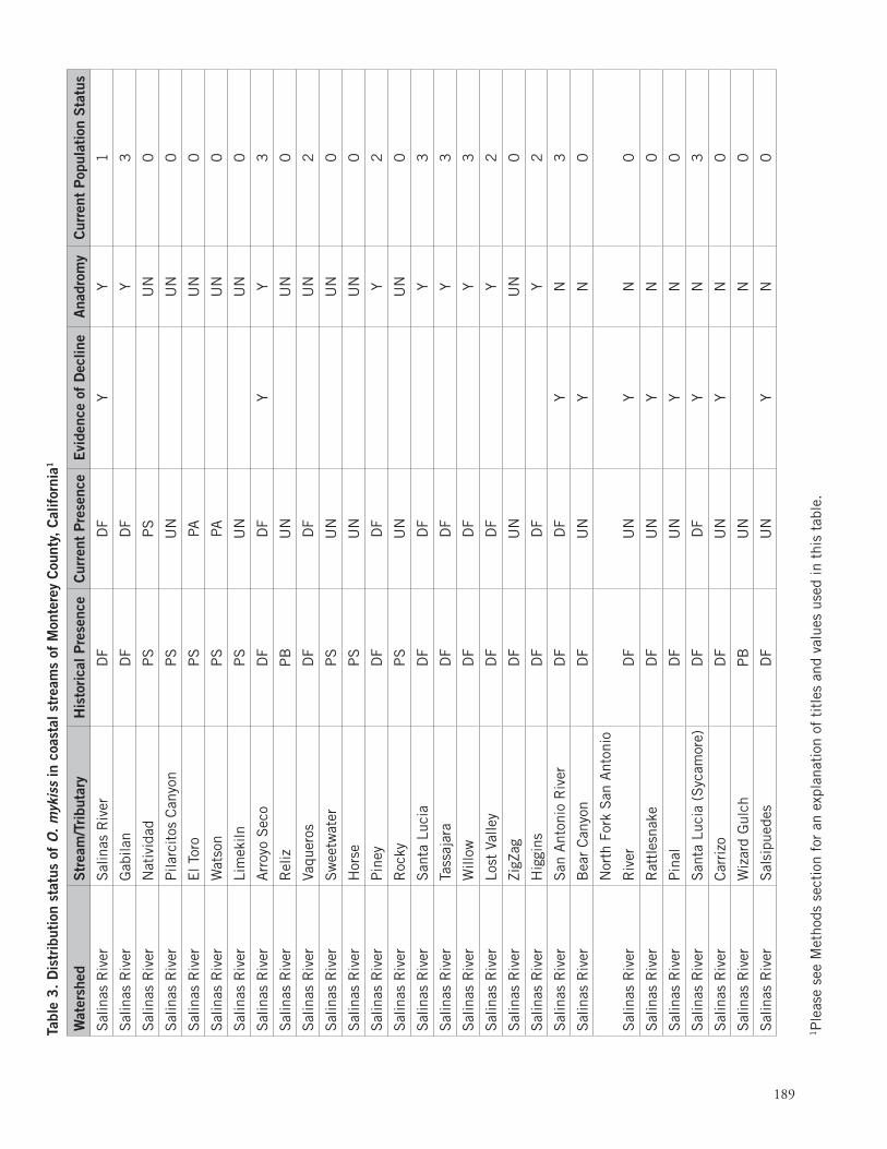
189
1P
leas
e se
e M
etho
ds s
ecti
on f
or a
n ex
plan
atio
n of
tit
les
and
valu
es u
sed
in t
his
tabl
e.
1P
leas
e se
e M
etho
ds s
ecti
on f
or a
n ex
plan
atio
n of
tit
les
and
valu
es u
sed
in t
his
tabl
e.
Tabl
e 3
. D
istr
ibut
ion
stat
us o
f O
. m
ykis
s in
coa
stal
str
eam
s of
Mon
tere
y C
ount
y, C
alif
orni
a1
Wat
ersh
edS
trea
m/T
ribu
tary
His
tori
cal P
rese
nce
Cur
rent
Pre
senc
eE
vide
nce
of D
eclin
eA
nadr
omy
Cur
rent
Pop
ulat
ion
Sta
tus
Sal
inas
Riv
erS
alin
as R
iver
DF
DF
YY
1
Sal
inas
Riv
erG
abila
nD
FD
FY
3
Sal
inas
Riv
erN
ativ
idad
PS
PS
UN
0
Sal
inas
Riv
erP
ilarc
itos
Can
yon
PS
UN
UN
0
Sal
inas
Riv
erE
l Tor
oP
SPA
UN
0
Sal
inas
Riv
erW
atso
nP
SPA
UN
0
Sal
inas
Riv
erLi
mek
ilnP
SU
NU
N0
Sal
inas
Riv
erA
rroy
o S
eco
DF
DF
YY
3
Sal
inas
Riv
erR
eliz
PB
UN
UN
0
Sal
inas
Riv
erVa
quer
osD
FD
FU
N2
Sal
inas
Riv
erS
wee
twat
erP
SU
NU
N0
Sal
inas
Riv
erH
orse
PS
UN
UN
0
Sal
inas
Riv
erP
iney
DF
DF
Y2
Sal
inas
Riv
erR
ocky
PS
UN
UN
0
Sal
inas
Riv
erS
anta
Luc
iaD
FD
FY
3
Sal
inas
Riv
erTa
ssaj
ara
DF
DF
Y3
Sal
inas
Riv
erW
illow
DF
DF
Y3
Sal
inas
Riv
erLo
st V
alle
yD
FD
FY
2
Sal
inas
Riv
erZi
gZag
DF
UN
UN
0
Sal
inas
Riv
erH
iggi
nsD
FD
FY
2
Sal
inas
Riv
erS
an A
nton
io R
iver
DF
DF
YN
3
Sal
inas
Riv
erB
ear
Can
yon
DF
UN
YN
0
Sal
inas
Riv
er
Nor
th F
ork
San
Ant
onio
Riv
erD
FU
NY
N0
Sal
inas
Riv
erR
attl
esna
keD
FU
NY
N0
Sal
inas
Riv
erP
inal
DF
UN
YN
0
Sal
inas
Riv
erS
anta
Luc
ia (
Syc
amor
e)D
FD
FY
N3
Sal
inas
Riv
erC
arri
zoD
FU
NY
N0
Sal
inas
Riv
erW
izar
d G
ulch
PB
UN
N0
Sal
inas
Riv
erS
alsi
pued
esD
FU
NY
N0
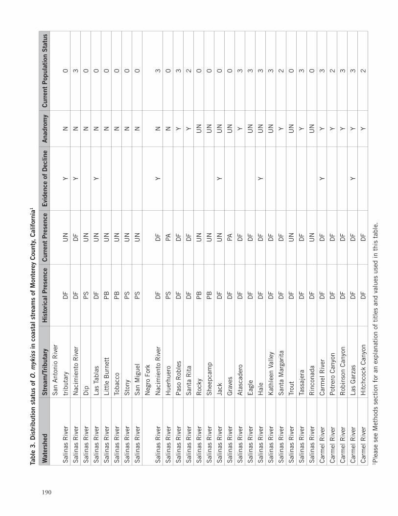
190
1P
leas
e se
e M
etho
ds s
ecti
on f
or a
n ex
plan
atio
n of
tit
les
and
valu
es u
sed
in t
his
tabl
e.
Tabl
e 3
. D
istr
ibut
ion
stat
us o
f O
. m
ykis
s in
coa
stal
str
eam
s of
Mon
tere
y C
ount
y, C
alif
orni
a1
1P
leas
e se
e M
etho
ds s
ecti
on f
or a
n ex
plan
atio
n of
tit
les
and
valu
es u
sed
in t
his
tabl
e.
Wat
ersh
edS
trea
m/T
ribu
tary
His
tori
cal P
rese
nce
Cur
rent
Pre
senc
eE
vide
nce
of D
eclin
eA
nadr
omy
Cur
rent
Pop
ulat
ion
Sta
tus
Sal
inas
Riv
er
San
Ant
onio
Riv
er
trib
utar
yD
FU
NY
N0
Sal
inas
Riv
erN
acim
ient
o R
iver
DF
DF
YN
3
Sal
inas
Riv
erD
ipP
SU
NN
0
Sal
inas
Riv
erLa
s Ta
blas
DF
UN
YN
0
Sal
inas
Riv
erLi
ttle
Bur
nett
PB
UN
N0
Sal
inas
Riv
erTo
bacc
oP
BU
NN
0
Sal
inas
Riv
erS
tony
PS
UN
N0
Sal
inas
Riv
erS
an M
igue
lP
SU
NN
0
Sal
inas
Riv
er
Neg
ro F
ork
Nac
imie
nto
Riv
erD
FD
FY
N3
Sal
inas
Riv
erH
uerh
uero
PS
PAN
0
Sal
inas
Riv
erP
aso
Rob
les
DF
DF
Y3
Sal
inas
Riv
erS
anta
Rit
aD
FD
FY
2
Sal
inas
Riv
erR
ocky
PB
UN
UN
0
Sal
inas
Riv
erS
heep
cam
pP
BU
NU
N0
Sal
inas
Riv
erJa
ckD
FU
NY
UN
0
Sal
inas
Riv
erG
rave
sD
FPA
UN
0
Sal
inas
Riv
erA
tasc
ader
oD
FD
FY
3
Sal
inas
Riv
erE
agle
DF
DF
UN
3
Sal
inas
Riv
erH
ale
DF
DF
YU
N3
Sal
inas
Riv
erK
athl
een
Valle
yD
FD
FU
N3
Sal
inas
Riv
erS
anta
Mar
gari
taD
FD
FY
2
Sal
inas
Riv
erTr
out
DF
UN
UN
0
Sal
inas
Riv
erTa
ssaj
era
DF
DF
Y3
Sal
inas
Riv
erR
inco
nada
DF
UN
UN
0
Car
mel
Riv
erC
arm
el R
iver
DF
DF
YY
3
Car
mel
Riv
erP
otre
ro C
anyo
nD
FD
FY
2
Car
mel
Riv
erR
obin
son
Can
yon
DF
DF
Y3
Car
mel
Riv
erLa
s G
arza
sD
FD
FY
Y3
Car
mel
Riv
erH
itch
cock
Can
yon
DF
DF
Y2
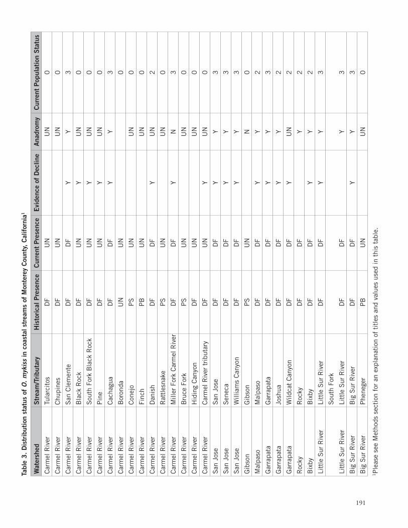
1P
leas
e se
e M
etho
ds s
ecti
on f
or a
n ex
plan
atio
n of
tit
les
and
valu
es u
sed
in t
his
tabl
e.
191
1P
leas
e se
e M
etho
ds s
ecti
on f
or a
n ex
plan
atio
n of
tit
les
and
valu
es u
sed
in t
his
tabl
e.
1P
leas
e se
e M
etho
ds s
ecti
on f
or a
n ex
plan
atio
n of
tit
les
and
valu
es u
sed
in t
his
tabl
e.
Tabl
e 3
. D
istr
ibut
ion
stat
us o
f O
. m
ykis
s in
coa
stal
str
eam
s of
Mon
tere
y C
ount
y, C
alif
orni
a1
Wat
ersh
edS
trea
m/T
ribu
tary
His
tori
cal P
rese
nce
Cur
rent
Pre
senc
eE
vide
nce
of D
eclin
eA
nadr
omy
Cur
rent
Pop
ulat
ion
Sta
tus
Car
mel
Riv
erTu
larc
itos
DF
UN
UN
0
Car
mel
Riv
erC
hupi
nes
DF
UN
UN
0
Car
mel
Riv
erS
an C
lem
ente
DF
DF
YY
3
Car
mel
Riv
erB
lack
Roc
kD
FU
NY
UN
0
Car
mel
Riv
erS
outh
For
k B
lack
Roc
kD
FU
NY
UN
0
Car
mel
Riv
erP
ine
DF
UN
YU
N0
Car
mel
Riv
erC
acha
gua
DF
DF
YY
3
Car
mel
Riv
erB
oron
daU
NU
N0
Car
mel
Riv
erC
onej
oP
SU
NU
N0
Car
mel
Riv
erFi
nch
PB
UN
UN
0
Car
mel
Riv
erD
anis
hD
FD
FY
UN
2
Car
mel
Riv
erR
attl
esna
keP
SU
NU
N0
Car
mel
Riv
erM
iller
For
k C
arm
el R
iver
DF
DF
YN
3
Car
mel
Riv
erB
ruce
For
kP
SU
NU
N0
Car
mel
Riv
erH
idin
g C
anyo
nD
FU
NU
N0
Car
mel
Riv
erC
arm
el R
iver
tri
buta
ryD
FU
NY
UN
0
San
Jos
eS
an J
ose
DF
DF
YY
3
San
Jos
eS
enec
aD
FD
FY
Y3
San
Jos
eW
illia
ms
Can
yon
DF
DF
YY
3
Gib
son
Gib
son
PS
UN
N0
Mal
paso
Mal
paso
DF
DF
YY
2
Gar
rapa
taG
arra
pata
DF
DF
YY
3
Gar
rapa
taJo
shua
DF
DF
YY
2
Gar
rapa
taW
ildca
t C
anyo
nD
FD
FY
UN
2
Roc
kyR
ocky
DF
DF
Y2
Bix
byB
ixby
DF
DF
YY
2
Litt
le S
ur R
iver
Litt
le S
ur R
iver
DF
DF
YY
3
Litt
le S
ur R
iver
Sou
th F
ork
Litt
le S
ur R
iver
DF
DF
Y3
Big
Sur
Riv
erB
ig S
ur R
iver
DF
DF
YY
3
Big
Sur
Riv
erP
hene
ger
PB
UN
UN
0
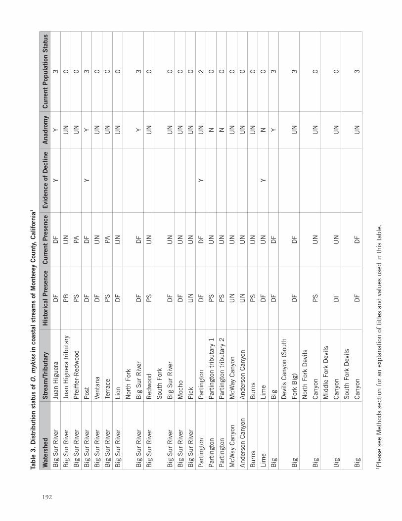
192
1P
leas
e se
e M
etho
ds s
ecti
on f
or a
n ex
plan
atio
n of
tit
les
and
valu
es u
sed
in t
his
tabl
e.
Tabl
e 3
. D
istr
ibut
ion
stat
us o
f O
. m
ykis
s in
coa
stal
str
eam
s of
Mon
tere
y C
ount
y, C
alif
orni
a1
1P
leas
e se
e M
etho
ds s
ecti
on f
or a
n ex
plan
atio
n of
tit
les
and
valu
es u
sed
in t
his
tabl
e.
Wat
ersh
edS
trea
m/T
ribu
tary
His
tori
cal P
rese
nce
Cur
rent
Pre
senc
eE
vide
nce
of D
eclin
eA
nadr
omy
Cur
rent
Pop
ulat
ion
Sta
tus
Big
Sur
Riv
erJu
an H
igue
raD
FD
FY
Y3
Big
Sur
Riv
erJu
an H
igue
ra t
ribu
tary
PB
UN
UN
0
Big
Sur
Riv
erP
feif
fer-
Red
woo
dP
SPA
UN
0
Big
Sur
Riv
erP
ost
DF
DF
YY
3
Big
Sur
Riv
erVe
ntan
aD
FU
NU
N0
Big
Sur
Riv
erTe
rrac
eP
SPA
UN
0
Big
Sur
Riv
erLi
onD
FU
NU
N0
Big
Sur
Riv
er
Nor
th F
ork
Big
Sur
Riv
erD
FD
FY
3
Big
Sur
Riv
erR
edw
ood
PS
UN
UN
0
Big
Sur
Riv
er
Sou
th F
ork
Big
Sur
Riv
erD
FU
NU
N0
Big
Sur
Riv
erM
ocho
DF
UN
UN
0
Big
Sur
Riv
erP
ick
UN
UN
UN
0
Par
ting
ton
Par
ting
ton
DF
DF
YU
N2
Par
ting
ton
Par
ting
ton
trib
utar
y 1
PS
UN
N0
Par
ting
ton
Par
ting
ton
trib
utar
y 2
PS
UN
N0
McW
ay C
anyo
nM
cWay
Can
yon
UN
UN
UN
0
And
erso
n C
anyo
nA
nder
son
Can
yon
UN
UN
UN
0
Bur
nsB
urns
PS
UN
UN
0
Lim
eLi
me
DF
UN
YN
0
Big
Big
DF
DF
Y3
Big
Dev
ils C
anyo
n (S
outh
Fork
Big
)D
FD
FU
N3
Big
Nor
th F
ork
Dev
ils
Can
yon
PS
UN
UN
0
Big
Mid
dle
Fork
Dev
ils
Can
yon
DF
UN
UN
0
Big
Sou
th F
ork
Dev
ils
Can
yon
DF
DF
UN
3
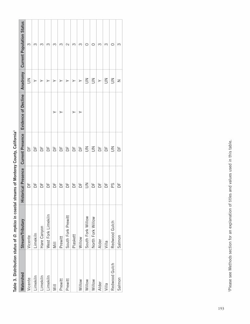
1P
leas
e se
e M
etho
ds s
ecti
on f
or a
n ex
plan
atio
n of
tit
les
and
valu
es u
sed
in t
his
tabl
e.
193
1P
leas
e se
e M
etho
ds s
ecti
on f
or a
n ex
plan
atio
n of
tit
les
and
valu
es u
sed
in t
his
tabl
e.
1P
leas
e se
e M
etho
ds s
ecti
on f
or a
n ex
plan
atio
n of
tit
les
and
valu
es u
sed
in t
his
tabl
e.
Tabl
e 3
. D
istr
ibut
ion
stat
us o
f O
. m
ykis
s in
coa
stal
str
eam
s of
Mon
tere
y C
ount
y, C
alif
orni
a1
Wat
ersh
edS
trea
m/T
ribu
tary
His
tori
cal P
rese
nce
Cur
rent
Pre
senc
eE
vide
nce
of D
eclin
eA
nadr
omy
Cur
rent
Pop
ulat
ion
Sta
tus
Vice
nte
Vice
nte
DF
DF
UN
3
Lim
ekiln
Lim
ekiln
DF
DF
Y3
Lim
ekiln
Har
e C
anyo
nD
FD
FY
3
Lim
ekiln
Wes
t Fo
rk L
imek
ilnD
FD
FY
3
Mill
Mill
DF
DF
YY
3
Pre
wit
tP
rew
itt
DF
DF
YY
3
Pre
wit
tS
outh
For
k P
rew
itt
DF
DF
Y2
P
lask
ett
DF
DF
YY
3
Will
owW
illow
DF
DF
YY
3
Will
owS
outh
For
k W
illow
UN
UN
UN
0
Will
owN
orth
For
k W
illow
DF
UN
UN
0
Ald
erA
lder
DF
DF
Y3
Villa
Villa
DF
DF
UN
3
Red
woo
d G
ulch
Red
woo
d G
ulch
PS
UN
UN
0
Sal
mon
Sal
mon
DF
DF
N3

194
1P
leas
e se
e M
etho
ds s
ecti
on f
or a
n ex
plan
atio
n of
tit
les
and
valu
es u
sed
in t
his
tabl
e.
Tabl
e 3
. D
istr
ibut
ion
stat
us o
f O
. m
ykis
s in
coa
stal
str
eam
s of
Mon
tere
y C
ount
y, C
alif
orni
a1