Embed Size (px)
Citation preview
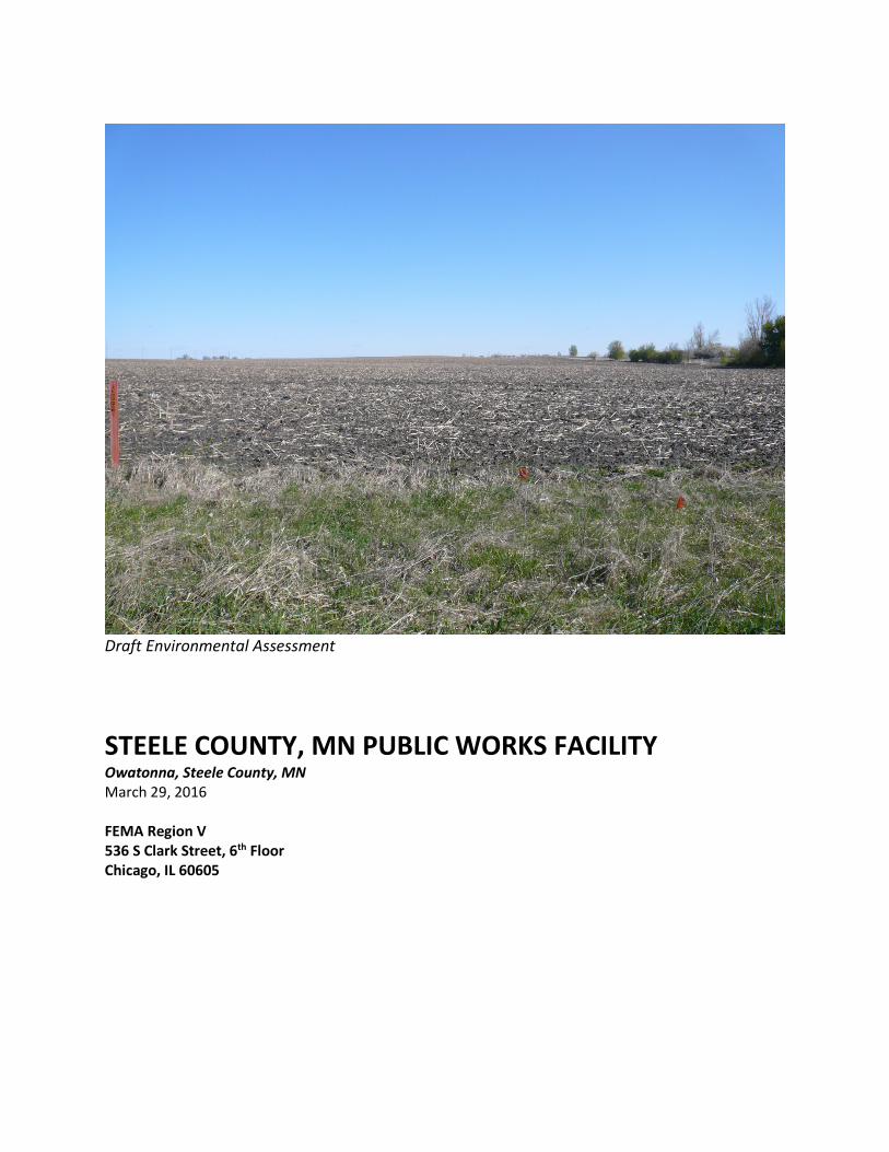
Draft Environmental Assessment
STEELE COUNTY, MN PUBLIC WORKS FACILITY Owatonna, Steele County, MN March 29, 2016 FEMA Region V 536 S Clark Street, 6th Floor Chicago, IL 60605
TITLE PAGE
ENVIRONMENTAL ASSESSMENT
for
STEELE COUNTY PUBLIC WORKS FACILITY
COUNTY OF STEELE, MINNESOTA
STEELE COUNTY PUBLIC WORKS 635 Florence Avenue Owatonna, MN 55060
and
DEPARTMENT OF HOMELAND SECURITY (DHS)/
FEDERAL EMERGENCY MANAGEMENT AGENCY (FEMA) REGION V
536 S Clark Street, 6th Floor Chicago, IL 60605
Document Prepared By:
Alison Harwood WSB & ASSOCIATES INC.
701 XENIA AVE S, STE 300 MINNEAPOLIS, MN
55416
and
Nicholas Mueller Regional Environmental Officer
Federal Emergency Management Agency, Region V
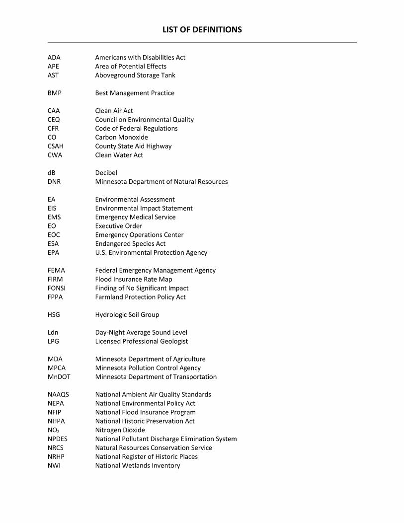
LIST OF DEFINITIONS ADA Americans with Disabilities Act APE Area of Potential Effects AST Aboveground Storage Tank BMP Best Management Practice CAA Clean Air Act CEQ Council on Environmental Quality CFR Code of Federal Regulations CO Carbon Monoxide CSAH County State Aid Highway CWA Clean Water Act dB Decibel DNR Minnesota Department of Natural Resources EA Environmental Assessment EIS Environmental Impact Statement EMS Emergency Medical Service EO Executive Order EOC Emergency Operations Center ESA Endangered Species Act EPA U.S. Environmental Protection Agency FEMA Federal Emergency Management Agency FIRM Flood Insurance Rate Map FONSI Finding of No Significant Impact FPPA Farmland Protection Policy Act HSG Hydrologic Soil Group Ldn Day-Night Average Sound Level LPG Licensed Professional Geologist MDA Minnesota Department of Agriculture MPCA Minnesota Pollution Control Agency MnDOT Minnesota Department of Transportation NAAQS National Ambient Air Quality Standards NEPA National Environmental Policy Act NFIP National Flood Insurance Program NHPA National Historic Preservation Act NO2 Nitrogen Dioxide NPDES National Pollutant Discharge Elimination System NRCS Natural Resources Conservation Service NRHP National Register of Historic Places NWI National Wetlands Inventory
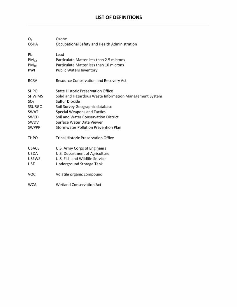
LIST OF DEFINITIONS O3 Ozone OSHA Occupational Safety and Health Administration Pb Lead PM2.5 Particulate Matter less than 2.5 microns PM10 Particulate Matter less than 10 microns PWI Public Waters Inventory RCRA Resource Conservation and Recovery Act SHPO State Historic Preservation Office SHWIMS Solid and Hazardous Waste Information Management System SO2 Sulfur Dioxide SSURGO Soil Survey Geographic database SWAT Special Weapons and Tactics SWCD Soil and Water Conservation District SWDV Surface Water Data Viewer SWPPP Stormwater Pollution Prevention Plan THPO Tribal Historic Preservation Office USACE U.S. Army Corps of Engineers USDA U.S. Department of Agriculture USFWS U.S. Fish and Wildlife Service UST Underground Storage Tank VOC Volatile organic compound WCA Wetland Conservation Act
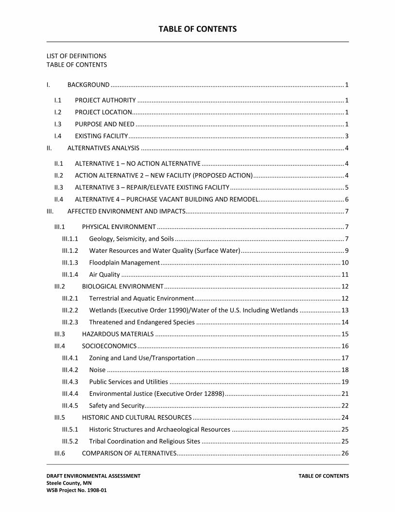
TABLE OF CONTENTS
DRAFT ENVIRONMENTAL ASSESSMENT TABLE OF CONTENTS Steele County, MN WSB Project No. 1908-01
LIST OF DEFINITIONS TABLE OF CONTENTS
I. BACKGROUND ................................................................................................................................... 1
I.1 PROJECT AUTHORITY .................................................................................................................... 1
I.2 PROJECT LOCATION....................................................................................................................... 1
I.3 PURPOSE AND NEED ..................................................................................................................... 1
I.4 EXISTING FACILITY ......................................................................................................................... 3
II. ALTERNATIVES ANALYSIS .................................................................................................................. 4
II.1 ALTERNATIVE 1 – NO ACTION ALTERNATIVE ................................................................................ 4
II.2 ACTION ALTERNATIVE 2 – NEW FACILITY (PROPOSED ACTION) ................................................... 4
II.3 ALTERNATIVE 3 – REPAIR/ELEVATE EXISTING FACILITY ................................................................ 5
II.4 ALTERNATIVE 4 – PURCHASE VACANT BUILDING AND REMODEL ................................................ 6
III. AFFECTED ENVIRONMENT AND IMPACTS ......................................................................................... 7
III.1 PHYSICAL ENVIRONMENT ......................................................................................................... 7
III.1.1 Geology, Seismicity, and Soils ............................................................................................... 7
III.1.2 Water Resources and Water Quality (Surface Water) .......................................................... 9
III.1.3 Floodplain Management ..................................................................................................... 10
III.1.4 Air Quality ........................................................................................................................... 11
III.2 BIOLOGICAL ENVIRONMENT ................................................................................................... 12
III.2.1 Terrestrial and Aquatic Environment .................................................................................. 12
III.2.2 Wetlands (Executive Order 11990)/Water of the U.S. Including Wetlands ....................... 13
III.2.3 Threatened and Endangered Species ................................................................................. 14
III.3 HAZARDOUS MATERIALS ........................................................................................................ 15
III.4 SOCIOECONOMICS .................................................................................................................. 16
III.4.1 Zoning and Land Use/Transportation ................................................................................. 17
III.4.2 Noise ................................................................................................................................... 18
III.4.3 Public Services and Utilities ................................................................................................ 19
III.4.4 Environmental Justice (Executive Order 12898) ................................................................. 21
III.4.5 Safety and Security.............................................................................................................. 22
III.5 HISTORIC AND CULTURAL RESOURCES ................................................................................... 24
III.5.1 Historic Structures and Archaeological Resources ............................................................. 25
III.5.2 Tribal Coordination and Religious Sites .............................................................................. 25
III.6 COMPARISON OF ALTERNATIVES ............................................................................................ 26
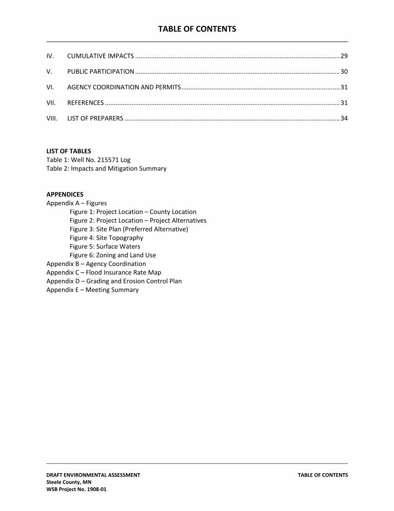
TABLE OF CONTENTS
DRAFT ENVIRONMENTAL ASSESSMENT TABLE OF CONTENTS Steele County, MN WSB Project No. 1908-01
IV. CUMULATIVE IMPACTS ................................................................................................................... 29
V. PUBLIC PARTICIPATION ................................................................................................................... 30
VI. AGENCY COORDINATION AND PERMITS ......................................................................................... 31
VII. REFERENCES .................................................................................................................................... 31
VIII. LIST OF PREPARERS ......................................................................................................................... 34
LIST OF TABLES Table 1: Well No. 215571 Log Table 2: Impacts and Mitigation Summary APPENDICES Appendix A – Figures Figure 1: Project Location – County Location Figure 2: Project Location – Project Alternatives Figure 3: Site Plan (Preferred Alternative) Figure 4: Site Topography Figure 5: Surface Waters Figure 6: Zoning and Land Use Appendix B – Agency Coordination Appendix C – Flood Insurance Rate Map Appendix D – Grading and Erosion Control Plan Appendix E – Meeting Summary
SECTION I
DRAFT ENVIRONMENTAL ASSESSMENT Steele County, MN WSB Project No. 1908-01 Page 1
I. BACKGROUND
I.1 PROJECT AUTHORITY
Steele County, Minnesota has applied to the Federal Emergency Management Agency (FEMA) for assistance with replacing the existing flood damaged Steele County Highway Operations Complex with a Public Works Facility located outside of the floodplain. The project is funded under Minnesota Severe Storms and Flooding (DR-1941-MN), Project worksheets 939, 941, 952, 947, and 959. This Environmental Assessment (EA) has been prepared in accordance with the National Environmental Policy Act (NEPA) of 1969, the President’s Council on Environmental Quality regulations to implement NEPA (40 Code of Federal Regulations Parts 1500-1508), and FEMA’s regulations implementing NEPA (44 CFR Part 10). FEMA is required to consider potential environmental impacts before funding or approving actions and projects. The purpose of the EA is to analyze the potential environmental impacts of the new Steele County Public Works Facility, and to use the findings in this EA to determine whether to prepare an Environmental Impact Statement (EIS) or a Finding of No Significant Impact (FONSI).
I.2 PROJECT LOCATION Steele County is located in southeastern Minnesota (Figure 1, Appendix A). The original, flood damaged Public Works Facility consists of five buildings on adjacent properties and is located at 828 Hoffman Drive N. and 360 North Street, Owatonna, MN. The proposed Public Works Facility, Alternative 2, will be located near the northwest city limits of Owatonna, Minnesota which is located on Interstate 35, approximately 45 miles south of the Minneapolis/St. Paul Metro Area. Specifically, the new facility will be located north of County State Aid Highway 2 (CSAH 2, formerly US Highway 14), approximately 4,400 feet west of Interstate 35 (Figure 2, Appendix A). The City of Owatonna has a population of approximately 25,600, while the population of Steele County is about 36,500 (US Census, 2010).
I.3 PURPOSE AND NEED The objectives of the FEMA's Public Assistance Grant Program are to assist communities in recovering from the damage caused by natural disasters. The purpose of the proposed project is to construct a Public Works Facility that provides the county with a safe, reliable, and consolidated space to perform all public works operations necessary for the County. When referring to Public Works, Steele County includes three departments within this area of its government: the Environmental Services Department, the Planning and Zoning Department, and the Transportation (Highway) Department. See, Steele County Public Works, http://www.co.steele.mn.us/public_works.html. The benefits of a consolidated Public
SECTION I
DRAFT ENVIRONMENTAL ASSESSMENT Steele County, MN WSB Project No. 1908-01 Page 2
Works Facility would include access during large flood events, improved facility conditions for staff and the public, and improvements to other deficiencies and needs. The existing Public Works site has several deficiencies. The primary deficiency is that the site is located within a FEMA-mapped 100-year floodplain. Since the facility was constructed in the 1930s, it has flooded to inoperable levels twice; once in 1965, under MnDOT ownership, and again in 2010, under County ownership. This flooding made the site inaccessible which significantly hindered the Highway Department’s ability as first responders, especially during natural disasters such as floods. During the 2010 floods the County Public Works emergency response materials and equipment needed during the flood were evacuated during the flood event. Emergency management and highway personnel had to be dedicated to evacuation of the site and were therefore unavailable to assist in other emergency operations. The evacuated equipment was moved to various offsite facilities. The lack of availability of personnel coupled with the lack of a central operations facility for all equipment and personnel resulted in decreased response times during a natural disaster. A need exists to provide protection to the public during flood events by having County Public Works first responders available with materials, equipment, and an operations base at all times. Other site needs and deficiencies at the existing facility include: • Inadequate salt/sand storage, main storage offsite at MnDOT facility • Insufficient storage space for vehicles and equipment, no drive aisles, equipment
crammed in • No vehicle wash areas • Inadequate vehicle servicing and maintenance space resulting in equipment being
serviced in truck bays, parking lot, and contracted out • Roof height limits the ability to lift equipment for repair • Site is difficult to secure • Above-ground fuel tanks are undersized for current vehicle fuel needs • Site is not Americans with Disabilities Act (ADA) compliant • Inadequate staff space- Highway Administrative, Engineering, and Maintenance
management staff is housed in a separate location Since the 2010 flood, the maintenance operations moved to a temporary leased facility that is insufficient for highway department use. Deficiencies of the leased facility include: • Building undersized for county’s needs • Limited security • No fuel tanks present at the site to permit the fueling of operations vehicles In accordance with federal laws and FEMA regulations, the EA process for a proposed federal action must include an evaluation of alternatives and a discussion of the potential environmental impacts. This EA was prepared in accordance with FEMA's
SECTION I
DRAFT ENVIRONMENTAL ASSESSMENT Steele County, MN WSB Project No. 1908-01 Page 3
regulations as required under NEPA. As part of this NEPA review, the requirements of other environmental laws and executive orders are addressed.
I.4 EXISTING FACILITY The existing Public Works Facility site is 7.19 acres in size and, prior to vacancy, provided about 40,000 square feet of space for the following public works and public safety departments’ facilities and amenities: • Steele County Highway Department Maintenance Operations • Veteran's Service Van Garage • S.W.A.T. Vehicle Storage • Sheriff's Evidence Storage • Secondary Sand/Salt and Equipment Storage – 360 North Street About 21,500 square feet of offsite space is also used for county public works, public safety and emergency management facilities/amenities that do not fit onsite. These facilities/amenities include: • Office Annex for Administration, Engineering, and Maintenance Staff • Highway Vehicle Storage Annex • Highway Vehicle Storage Landfill • Primary Salt/Sand Storage – MnDOT Facility • Secondary Sheriff's Storage • Emergency Management Equipment Storage – various locations County wide The facility is located in the northwest quadrant of the intersection of Hoffman Drive and West North Street, and on the west side of Hoffman Drive south of North Street in Owatonna Minnesota (Alternative 3 location, Figure 2, Appendix A). Specifically, the facility is located at 828 Hoffman Drive N. and 360 North Street, Owatonna, MN in Section 9, Township 107N, Range 20W at geographic coordinates 44° 5’ 32.32” N, 93° 13’ 48.35” W. This facility is currently within 250 feet of the Straight River, within a FEMA-designated 100-year floodplain. The offsite spaces are located at various areas throughout Steele County.
SECTION III
DRAFT ENVIRONMENTAL ASSESSMENT Steele County, MN WSB Project No. 1908-01 Page 4
II. ALTERNATIVES ANALYSIS As part of the NEPA process, all reasonable alternatives to the Proposed Action must be analyzed. Reasonable alternatives are those that are considered practical or feasible from the technical and economic standpoint, as well as from a common sense standpoint. This section provides information on the development and evaluation of the no action alternative, Proposed Action alternative, and other alternatives considered and eliminated. The development of alternatives is directly related to the purpose and need for the project.
II.1 ALTERNATIVE 1 – NO ACTION ALTERNATIVE Under this alternative, no action would be taken in response to the purpose and need. The Public Works Facility would remain within the floodplain and would continue to flood to levels that make the site inaccessible. The other site deficiencies listed in Section 1.3 would also not be addressed.
II.2 ACTION ALTERNATIVE 2 – NEW FACILITY (PROPOSED ACTION) Under this alternative, Steele County would ultimately use a new, purchased site to house the existing public works facilities, described in Section I.4. The Proposed Action project area is located at PID 170053400, north of CSAH 2, approximately 4,400 feet west of Interstate 35, in the southwest 1/4 of Section 5, Township 107N, Range 20W (Figure 2, Appendix A). The geographic coordinates of the proposed project area are 44° 5' 52.25" N, 93° 15' 51.97" W. The proposed project area itself is an agricultural crop field. The site is surrounded on the northwest by agricultural crop land, on the east residential and commercial, and on the south by rural residential and industrial land.
The entire proposed site is approximately 45 acres in size, although only 24.25 acres would be disturbed immediately for the new facility. Approximately 1.62 acres would be used for the facility building, 3.57 acres for pavement or class V rock pad, and 19.06 acres of green pervious surface. The remaining 20.75 acres would be available for future facility expansion. In the interim, these remaining acres could be leased as farmland. The site would provide space for the following facilities and amenities (also shown on Figure 3, Appendix A): • Offices for Administration, Engineering, and Maintenance Staff • 60-stall parking lot • Vehicle Storage • Veteran's Service Van Garage • Vehicle Maintenance and Wash Areas • Fueling Island containing two, 10,000 gallon below ground tanks located along the
asphalt pavement entrance to the southeast of the building • Lab Space • Salt/Sand Storage Building (5,376 sq ft) with fabric cover and concrete ‘T’ push
walls • Brine Building containing two, 2,000 gallon storage tanks and mixing tank
SECTION III
DRAFT ENVIRONMENTAL ASSESSMENT Steele County, MN WSB Project No. 1908-01 Page 5
• Highway Department Vehicle Storage • Exterior Class V Rock Pad Storage Yard (1.67 ac) • Security Gate • Two stormwater ponds located along the south side of the property with a total
storage capacity of approximately 5.7 acre-feet. • Space for Future Expansion: possible emergency management vehicle and
equipment storage, Sheriff’s storage, impound storage, interior storage building, emergency management equipment and vehicle storage among other County facility needs.
All of the facilities listed in Section I.4 (both on and off-site) would be housed on the proposed site, with the exception of: • S.W.A.T. Vehicle Storage • Sheriff’s Evidence Storage, Secondary Sheriff's Storage • Emergency Management Equipment Storage
These needs are currently being met at other locations. The preliminary construction plans call for grading and paving of the existing area and construction of buildings or areas to house the above-listed facilities. Stormwater ponds would be constructed onsite to address stormwater runoff from the new impervious surfaces. The types of equipment typical of commercial facility construction would be used to construct this facility. Utilities for the facility would be connected to the City of Owatonna's existing systems which are adjacent to the site.
II.3 ALTERNATIVE 3 – REPAIR/ELEVATE EXISTING FACILITY Five buildings were originally located at the existing facility; one at 360 W North Street and four at 828 Hoffman Drive. The building located at 360 W North Street was demolished in 2011. Alternative 3 would involve repairing two of the four remaining buildings that were substantially damaged during the 2010 flood. These buildings have been vacant since 2010, when maintenance operations moved to a temporary facility. The flood resulted in standing water in two of the buildings that lasted for four days. The damage included furnishings and equipment and structurally damaged and contaminated wood, masonry, and mortar. Cost estimates to repair the damage to these two buildings exceeded half of the property’s market value. In addition to repairing the flood-damaged buildings, all four of the remaining buildings would be required to be in compliance with the local floodplain ordinance. Bringing the buildings into compliance with the floodplain ordinance would involve either constructing flood walls or raising the elevation of the land. Due to site constraints and cost, building flood walls was not a feasible solution. Therefore, all of the existing buildings would need to be demolished and the site elevation raised 5 feet out of the floodplain. This would result in needing to place approximately 4.55 acre-feet of fill material at the Hoffman Drive site and 5.59 acre-feet of fill at the North Street site. This
SECTION III
DRAFT ENVIRONMENTAL ASSESSMENT Steele County, MN WSB Project No. 1908-01 Page 6
increase in elevation would cause all access roads to the buildings to be at a 6% grade and the public roadway access to the sites would remain within the floodplain rendering the site inaccessible during floods. Effectively, this alternative requires the demolition and replacement of all the existing buildings. Although this alternative would bring the facilities into compliance with floodplain ordinance requirements and replace the flood-damaged building, several deficiencies would remain as detailed in Section I.3. These deficiencies would be exacerbated due to the reduction in usable land area from raising the site approximately 5 feet to meet floodplain ordinance requirements. The facility would experience the following deficiencies:
• The floodplain ordinance and setbacks would result in a building design that
would make maneuvering large trucks and equipment difficult. • The overall size of the building would have to be reduced to meet the floodplain
ordinance and setback requirements and therefore would not provide adequate space for Public Works operations. Some equipment would have to be stored offsite.
• Although the building site itself would be raised out of the floodplain, the road that provides access to the site would remain within the floodplain. As a result, access to the site would be restricted during major flood events, such as the flood that occurred in 2010.
• The facilities would not have adequate space for salt/sand storage. Under Alternative 3, the County would need to expand its use of offsite facilities to meet the basic Highway Department operational space needs. The existing site (7.19 acres) and buildings (39,350 square feet) were already undersized for modern highway operations and many pieces of equipment were already stored elsewhere prior to the 2010 flood (e.g., salt and sand storage, pipe and materials stockpiles). An estimated 70,000 square feet of space is required to house all County Highway operations staff and equipment in one location. A reduction in the size of the building would result in inefficient design and added operation costs due to storage of equipment offsite.
II.4 ALTERNATIVE 4 – PURCHASE VACANT BUILDING AND REMODEL
Alternative 4 would involve purchasing an existing facility and repurposing the building to fit the needs of the county. The proposed property was a manufacturing facility and is located approximately one mile south of Owatonna, within Owatonna Township in parcels 08-125-0101 and 08-119-0101 (Figure 2, Appendix A). The building is approximately 147,472 square feet, which is larger than the county requires for the Public Works Facility. Due to its age and set up (purposed for a manufacturing facility), remodeling of the existing facility would be necessary prior to being usable as a public works facility. The facility would be large enough to house all of the county facilities/amenities, but a portion of the building would need to be left vacant to reduce operating costs. No city sewer or water services are available and would need to be brought in or provided via septic systems and wells. The Township would lose a tax base if the property were to become a public facility. The Township passed a Resolution objecting to County acquisition of this site due to concerns with loss of tax base. The
SECTION III
DRAFT ENVIRONMENTAL ASSESSMENT Steele County, MN WSB Project No. 1908-01 Page 7
City of Owatonna expressed preference that this facility to remain a manufacturing facility, although vacant at the time, to market as an economic development opportunity for a new business to locate or an existing businesses to expand.
III. AFFECTED ENVIRONMENT AND IMPACTS
III.1 PHYSICAL ENVIRONMENT
The proposed facility is located on the west side of Owatonna north of CSAH 2 on the fringe of the City (Figure 2, Appendix A). The site lies in a stable geologic terrain underlain by Wisconsin Age glacial till which cover Paleozoic sedimentary rock. The topography is level to slightly undulating and the thick soils have traditionally been used for row crops and pasture.
III.1.1 Geology, Seismicity, and Soils Surficial Geology: According to the Minnesota Geological Survey, unconsolidated glacial drift covers all of Steele County to a depth of more than 50 feet; no bedrock is found at or near the surface in the vicinity of the proposed new Public Works Facility. A review of eight well drilling records available from the Minnesota Department of Health County Well Index for a one mile radius of the site shows that first encountered bedrock is at a depth of 70 to 90 feet. A mixture of clay rich glacial drift inter-bedded with thin layers of sand underlies the site. Bedrock Geology and Aquifers: The first encountered bedrock of the area is the Upper Ordovician Age (450 million year old) Galena Limestone; a hard, gray, fractured limestone that is a locally important aquifer. Wells completed into the fractured Galena limestone have static water levels of 39 to 49 feet below the surface. Underlying the Galena Limestone is the 100 foot thick Decorah Shale, Platteville Limestone, and Glenwood Shale; a 120 foot sequence of rocks that are considered confining units and aquitards that separate the shallower Galena aquifer from the deeper St. Peter Sandstone, a high yielding sandstone aquifer. The 343 foot deep well, Unique Number 215571, located in the southwest 1/4 of the southwest 1/4S of Section 6, Township 107 N, and Range 20 W, logs the following stratigraphic units and depths.
Table 1: Well No. 215571 Log
Formation Depth From Depth to Glacial Drift 0 80 Galena Limestone 80 120 Decorah Shale 120 223 Platteville Limestone 223 235 Glenwood Shale 235 240 St. Peter Sandstone 240 343
SECTION III
DRAFT ENVIRONMENTAL ASSESSMENT Steele County, MN WSB Project No. 1908-01 Page 8
Steele County has not yet been mapped by the County Geologic Atlas program; however, geologic maps produced at a scale of 1:100,000 show the site to be near the center of the Hollandale embayment, a broad synclinal depositional basin that is structurally stable and does not display structural faults. Seismicity and Earthquake Risk A review of the site seismicity was conducted by Jeffrey S. Broberg, a Minnesota Licensed professional Geologist (LPG #30019) and revealed that Steele County is located in the seismically inactive Glaciated Paleozoic Plateau which is underlain by Paleozoic sedimentary rock in the middle of the North American craton. A review of data from the United States Geologic Survey Seismicity Data for the years 1973 through March 2012 show no seismicity or earthquakes in Steele County or anywhere within 150 miles northwest of the site. There have been no historically recorded seismic events to affect the geology or soils in the area. There is little to no likelihood of a seismicity event causing property damage at the site or in the vicinity of the site. Soils The U.S. Department of Agriculture (USDA), Natural Resources Conservation Service’s (NRCS) Soil Survey Geographic (SSURGO) Database for Steele County classified the soils within the proposed project area (Proposed Action) as Clarion loam with 2 to 12 percent slopes, Nicollet loam with 0 to 4 percent slopes, and Webster loam. The soils have moderate (Hydrologic Soil Group; HSG of B) to very low (HSG of B/D) infiltration potential. The Webster loam soils are considered hydric. The Farmland Protection Policy Act (FPPA) (Pub. L. 97-98, Sec. 1539-1549; 7 U.S.C. §§ 4201, et seq.), which states that federal agencies must "minimize the extent to which Federal programs contribute to the unnecessary and irreversible conversion of farmland to nonagricultural uses" was considered in this EA. 7 U.S.C. § 4201(b). Portions of the proposed project area are considered prime farmland. Areas classified as prime farmland are generally subject to the FPPA. The FPPA form AD 1006 was completed and submitted to the NRCS for review (Appendix B). No comments have been received to date and mitigation for impacts to prime farmland is not anticipated to be required. Alternative 1: No Action – Under the No Action Alternative no impacts to geology, seismicity, or soils are anticipated. Alternative 2: New Site and Facility (Proposed Action) – Under Alternative 2, the construction activities are not anticipated to be deep enough to impact underlying geologic resources. Temporary, short-term impacts to the soils are anticipated during construction. A Stormwater Pollution Prevention Plan (SWPPP) and Erosion Control Plan will be created for the project. Stormwater Best Management Practices (BMPs) would be implemented during construction to reduce the risk of erosion
SECTION III
DRAFT ENVIRONMENTAL ASSESSMENT Steele County, MN WSB Project No. 1908-01 Page 9
from the site. BMPs implemented during construction may include, but are not limited to, silt fencing, covering of stock-piled soils, and turf establishment within 14 days of completing soil-disturbing activities. The NRCS was consulted regarding the Farm Protection Policy Act (FPPA). Although some of the site contains areas of prime farmland, mitigation for impacts to these areas is not anticipated. Alternative 3: Repair/Elevate Existing Facility – Under this alternative, no impacts to the underlying geologic features or farmland are anticipated. Significant fill placement needs to occur to raise the sites approximately 5 feet in order to meet floodplain ordinance. A SWPPP and Erosion Control Plan would be developed for the site. Stormwater BMPs such as silt fence would be implemented during construction. Stock-piling of soils would not be expected under this alternative. Alternative 4: Purchase Vacant Buildings and Renovate – Under Alternative 4, no impacts to the underlying geologic features are anticipated. Soil disturbance would be minimal and temporary in nature. A SWPPP and Erosion Control Plan would be developed for the site. Stormwater BMPs such as silt fence would be implemented during construction. Stock-piling of soils would not be expected under this alternative.
III.1.2 Water Resources and Water Quality (Surface Water) The Clean Water Act (CWA), as amended in 1977, 33 U.S.C. § 1251 et seq., established the basic framework for regulating discharges of pollutants into waters of the United States. The nearest waterbodies to the proposed site are Lake Chase located approximately 1.2 miles to the northeast, Crane Creek located 1.80 miles to the west, and the Straight River located 1.60 miles to the east. Several small wetlands also occur within 1 mile of the proposed site, with the nearest being an excavated shallow open water wetland (PUBHx) located approximately 700 feet northwest of the site. Existing site topography is shown on the Figure 4, Appendix A. The 44.3-acre project area is currently an agricultural field used for crop production. The topography of the project area is generally flat with a slight sloping to the southeast. The proposed project consists of a single-story public works facility with a parking lot and sidewalks around the building. (Figure 3, Appendix A) New curb and gutter and storm sewer will be constructed to drain runoff from the parking lot. Sufficient stormwater detention volume will be provided to compensate for new impervious area that is being constructed. The proposed site grading plan includes two stormwater basins located on the south side of the project area. The west pond has a storage capacity volume of 2.54 acre-feet and the east pond has a storage capacity volume of 3.16 acre-feet. Additional details are provided in the Grading and Erosion Control Plans provided in Appendix D. Alternative 1: No Action – Under the No Action alternative, no adverse impacts to surface waters are anticipated.
SECTION III
DRAFT ENVIRONMENTAL ASSESSMENT Steele County, MN WSB Project No. 1908-01 Page 10
Alternative 2: New Site and Facility (Proposed Action) – Under the Proposed Alternative, permanent impacts to surface waters are not anticipated. All runoff from impervious surfaces would be retained onsite by being directed to stormwater basins prior to discharge. Outlet structures at the stormwater basins discharge to the north roadside ditch along CSAH 2 and do not flow directly to a Public Water. The County would also implement appropriate BMPs, such as installing silt fences and revegetation of bare soils in order to reduce transport of sediment.
Alternative 3: Repair/Elevate Existing Facility – The nearest waterbody to the existing site is the Straight River, located approximately 250 feet to the east. Under this alternative the existing, vacant, public works facility would be brought into compliance with floodplain ordinance by raising the site by 5 feet. The existing buildings would be demolished and rebuilt. The existing site is currently paved and runoff is directed to the City’s storm sewer system. This system would remain in place following construction. The County would implement appropriate BMPs during construction, such as installing silt fences and revegetation of bare soils in order to reduce impacts to downstream surface waters. Permanent impacts to surface waters would not be expected. Fill would be placed within the floodplain, which is discussed in Section III.1.3, below. Alternative 4: Purchase Vacant Building and Renovate – Under Alternative 4, an existing manufacturing facility south of Owatonna would be purchased and renovated for use by Steele County. The building proposed to be purchased is located 1.36 miles north of Turtle Creek and 1.45 miles east of the Straight River. The existing site consists of impervious surfaces and stormwater runoff is directed to infiltration basins. This method of stormwater treatment would remain under Alternative 4. The County would implement appropriate BMPs during construction, such as installing silt fences and revegetation of bare soils in order to reduce impacts to downstream surface waters. No permanent impacts to surface waters would be anticipated.
III.1.3 Floodplain Management (Executive Order 11988)
Executive Order (EO) 11988 requires federal agencies to take action to minimize occupancy and modification of the floodplain. Specifically, EO 11988 prohibits federal agencies from funding construction in the 100 year floodplain unless there are no practicable alternatives. FEMA’s regulations for complying with EO 11988 are promulgated in 44 C.F.R. Part 9. This project is not within the 100 year floodplain (or 500 year floodplain for critical facility) as indicated in the Flood Insurance Rate Map (FIRM), panel 271470132C, effective date 12/2/2011, for Steele County (Appendix C). Alternative 1: No Action – Under the no action alternative, no impacts to floodplain are anticipated.
SECTION III
DRAFT ENVIRONMENTAL ASSESSMENT Steele County, MN WSB Project No. 1908-01 Page 11
Alternative 2: New Site and Facility (Proposed Action) – Under the Proposed Action, no floodplain impacts are anticipated. The development of a Public Works Facility at a site located outside of the floodplain will provide numerous benefits to the County. This proposed alternative does not affect a floodplain by placing fill and potentially altering water levels. Additionally, the new site will consolidate all of the County public works operations into one facility, enabling personnel easy and efficient access to all equipment and increasing preparedness of the County. Locating the facility outside of the floodplain improves the safety of the community by allowing the County’s first responders to have continued access to the operations base and equipment during natural disasters such as floods.
Alternative 3: Repair/Elevate Existing Facility – Under this alternative, the existing buildings would be required to be in compliance with floodplain ordinances, which would involve either constructing flood walls or raising the elevation of the land. County consultants evaluated these options and raising the sites was determined to be the most cost effective solution over flood walls. This alternative would result in fill within FEMA floodplain and a critical County facility remaining within the 100 year floodplain. Placement of fill within the floodplain may negatively impact downstream communities by limiting available storage capacity within the floodplain and potentially raising the levels of flooding. Even with the raised site, the facilities would remain inaccessible during flood events due to access road flooding. Alternative 4: Purchase Vacant Buildings and Renovate – Under Alternative 4, no floodplain impacts are anticipated. The building that would be purchased by the county for this alternative is not located in the 100 year floodplain (FEMA FIRM 27147C0161C, effective date 12-2-2011).
III.1.4 Air Quality
The Clean Air Act, 42 U.S.C. § 7401 et seq., requires the U.S. Environmental Protection Agency (EPA) to set National Ambient Air Quality Standards (NAAQS) for pollutants considered harmful to public health and the environment. The Clean Air Act established two types of national air quality standards:
1. Primary standards set limits to protect public health, including the health of "sensitive" populations such as asthmatics, children, and the elderly.
2. Secondary standards set limits to protect public welfare including protection against decreased visibility and damage to animals, crops, vegetation, and buildings.
The current criteria pollutants are: Carbon Monoxide (CO), Nitrogen Dioxide (NO₂), Ozone (O₃), Lead (Pb), Particulate Matter (PM₁₀) and Sulfur Dioxide (SO₂). The proposed project area is not located within an air quality attainment area.
SECTION III
DRAFT ENVIRONMENTAL ASSESSMENT Steele County, MN WSB Project No. 1908-01 Page 12
Alternative 1: No Action – Under the No Action Alternative, no impacts to air quality would be expected because construction would not occur. Alternative 2: New Site and Facility (Proposed Action) – Under the Proposed Action Alternative, temporary, minor air quality impacts are anticipated as a result of the construction on the parcel. To reduce these impacts, the project proponent would require construction contractors to water down construction areas as necessary to reduce the risk of fugitive dust and maintain factory-installed emissions controls on their equipment that meet state emissions standards. Although emissions from fuel-burning equipment could increase the levels of some criteria pollutants, these increases would be temporary and equipment would not be running unless necessary for construction. Alternative 3: Repair/Elevate Existing Facility – Under this alternative, temporary impacts are anticipated during the demolition and construction activities at the existing facility. To reduce impacts, construction contractors would be required to water down construction areas as necessary to reduce the risk of fugitive dust and maintain factory-installed emissions controls on their equipment that meet state emissions standards. Although emissions from fuel-burning equipment could increase the levels of some criteria pollutants, these increases would be temporary and equipment would not be running unless necessary for construction. Alternative 4: Purchase Vacant Buildings and Renovate – Under Alternative 4, temporary impacts are anticipated during renovation activities at the existing facility. To reduce impacts, construction contractors would be required to water down construction areas as necessary to reduce the risk of fugitive dust and maintain factory-installed emissions controls on their equipment that meet state emissions standards. Although emissions from fuel-burning equipment could increase the levels of some criteria pollutants, these increases would be temporary and equipment would not be running unless necessary for construction.
III.2 BIOLOGICAL ENVIRONMENT
III.2.1 Terrestrial and Aquatic Environment
The proposed project area has been used for agricultural production for at least the last 20 years and has limited value for wildlife or fish. The site is surrounded on the north and west by agricultural crop land and on the east by residential and commercial land uses. CSAH 2, which is a four lane divided highway, and one residence bound the project area to the south. Across from CSAH 2, residential and industrial land uses exist. A small grove of trees surrounds the residence to the south of the project and may provide habitat for wildlife that are accustomed to frequent disturbance such as robins, red-winged black birds, white-tailed deer, skunk, raccoon, and rabbits. Because the project area has been farmed, it provides little habitat value for wildlife species. There are no aquatic resources located in the project area.
SECTION III
DRAFT ENVIRONMENTAL ASSESSMENT Steele County, MN WSB Project No. 1908-01 Page 13
Alternative 1: No Action – Under the No Action Alternative, no impacts to wildlife or fish, or their habitats, are anticipated. Alternative 2: New Site and Facility (Proposed Action) – The proposed project is located within a cultivated agricultural field with no natural vegetation present. As a result, the project area has limited value for wildlife or fish. No impacts to fish and wildlife are expected during either the construction or operation phases. The new site will include two stormwater ponds, which may provide some habitat for waterfowl and amphibians. Alternative 3: Repair/Elevate Existing Facility – Under this alternative, no impacts to the immediate terrestrial environment are anticipated. The existing public works facility is surrounded on the north, south, and west by fully developed land and CSAH 2 is located to the east. The existing facilities have limited value for wildlife. The Straight River is located to the east of the existing facility and CSAH 45 (Hoffman Drive). Impacts to the aquatic environment could occur during construction as a result of decreased quality of stormwater runoff. These impacts would be minimized by using BMPs such as silt fence. In addition, the fill within the floodplain that would be required by this alternative could result in adverse impacts to downstream environments due to displacement of flood waters and potentially raising flood elevations downstream. Alternative 4: Purchase Vacant Buildings and Renovate – Under Alternative 4, the existing facility located at the site would be renovated to fulfill the needs of Steele County. No impacts to the terrestrial or aquatic environment are anticipated. The existing facility is surrounded by agricultural lands and rural residential areas. The existing facilities and surrounding areas have limited value for wildlife.
III.2.2 Wetlands (Executive Order 11990) / Water of the U.S. Including Wetlands
Executive Order (EO) 11990, Protection of Wetlands, requires federal agencies to minimize the loss of wetlands. The NEPA compliance process requires federal agencies to consider direct and indirect impacts to wetlands, which may result from federally-funded actions. Based on consultation with the Army Corps of Engineers (USACE), Steele County Soil and Water Conservation District (SWCD), and DNR no wetlands are located within the proposed project area (refer to Appendix B for record of correspondence). Alternative 1: No Action – Under the No Action Alternative, no impacts to wetlands would be expected since construction would not occur. Alternative 2: New Site and Facility (Proposed Action) – Under the Proposed Action Alternative, wetlands would not be impacted because no wetlands exist on site
SECTION III
DRAFT ENVIRONMENTAL ASSESSMENT Steele County, MN WSB Project No. 1908-01 Page 14
(Figure 5, Appendix A). This conclusion was made based on the following information:
• On April 9, 2012, correspondence was received from the Steele County SWCD, which is the regulatory authority for the Wetland Conservation Act (WCA), which stated that no jurisdictional wetlands exist on the proposed project area.
• On April 12, 2012, correspondence was received from the DNR stating that if no Public Waters are located on the proposed site, no permits or approvals from the DNR are necessary. Based on the Public Water Inventory (PWI) maps, no Public Waters exist on site.
• On April 27, 2012, Steele County Highway Department received correspondence from the USACE that indicated that the work proposed at the project location was not within the regulatory jurisdiction of the USACE.
• The National Wetlands Inventory (NWI) does not map any wetlands within the project area.
The record of correspondence from these agencies is located in Appendix B. The nearest mapped wetland is located approximately 700 feet northwest of the project area (Figure 5, Appendix A). Given the location of the project and slope of the landscape, indirect impacts to this wetland are not expected. During construction, BMPs to minimize the movement of sediment off of the project area will be implemented, as required by the NPDES permit.
Alternative 3: Repair/Elevate Existing Facility – There are no mapped NWI wetlands within the existing building site. The site is fully-developed. There are mapped NWI wetlands located east of the building site, adjacent to the Straight River. These wetlands would not be impacted by Alternative 3. Alternative 4: Purchase Vacant Buildings and Renovate – There are no mapped NWI wetlands located within either parcel. The site is currently developed as a manufacturing operation. Renovation of the existing buildings to meet the needs of Steele County would not impact any wetlands.
III.2.3 Threatened and Endangered Species The proposed project area is located within an existing agricultural crop field northwest of Owatonna. The site and surrounding lands have been in agricultural production for at least the past 20 years. In accordance with Section 7 of the Endangered Species Act (ESA) of 1973, 16 U.S.C. § 1531, Sec. 7, the project area was evaluated for the potential occurrences of federally listed threatened and endangered species. The ESA requires any federal agency that funds, authorizes, or carries out an action to ensure that their action is not likely to jeopardize the continued existence of any endangered or threatened
SECTION III
DRAFT ENVIRONMENTAL ASSESSMENT Steele County, MN WSB Project No. 1908-01 Page 15
species (including plant species) or result in the destruction or adverse modification of designated critical habitats. On October 15, 2015, FEMA completed a review in accordance with Section 7 of the ESA and determined that there were two federally listed species within Steele County. These species are listed below:
• Northern long-eared bat (Myotis septentrionalis) – Threatened: Habitat includes caves and mines in the winter, upland forests in the spring and summer, and wooded areas in the fall.
• Dwarf trout lily (Erythronium propullans) – Endangered: Habitat includes north-facing slopes and floodplains in deciduous forests.
Both listed species have habitat requirements that do not exist within the project area. The proposed project will have no adverse effect on the listed species. Documentation of the “no effect” determination is provided in Appendix B.
A review of the DNR’s Natural Heritage Information Database (License No. LA-685) was also conducted and revealed one species within one mile of the project area. This species, rattlesnake master (Eryngium yucifolium), is located approximately 0.50 mile southwest of the project area. The plant itself occurs primarily in prairies. Alternative 1: No Action – Under the No Action Alternative, no impacts to threatened or endangered species or their critical habitats are anticipated. Alternative 2: New Site and Facility (Proposed Action) – The proposed project is located within a cultivated agricultural field with no natural vegetation present. As a result, none of the rare species listed above or their habitats are likely to be present on site. No impacts to these species will occur during either the construction or operation phases. Correspondence from the applicable agencies is included in Appendix B. Alternative 3: Repair/Elevate Existing Facility – This alternative would not result in impacts to any threatened or endangered species. Alternative 4: Purchase Vacant Buildings and Renovate – Renovation of the existing facility located at PIN 081250101 and 081190101 would not involve manipulation of the surrounding land use, so would not result in impacts to any threatened or endangered species.
III.3 HAZARDOUS MATERIALS The Minnesota Pollution Control Agency’s (MPCA) What’s in My Neighborhood and Minnesota Department of Agriculture’s (MDA) What’s in My Neighborhood databases were reviewed for potential hazardous materials.
SECTION III
DRAFT ENVIRONMENTAL ASSESSMENT Steele County, MN WSB Project No. 1908-01 Page 16
Alternative 1: No Action – Under the No Action Alternative, the existing building site would remain vacant and secured by the county until such time that a redevelopment plan is developed or the property is sold. Based on a review of the MPCA’s What’s In My Neighborhood database search, there is one aboveground storage tank (AST) at the site. There are no underground storage tanks (UST) located on the site. One leak has been identified at the site and may have contaminated the groundwater. This record has been closed, although closure of the site does not preclude the potential for remaining contamination. An inspection of the existing buildings for hazardous materials such as lead paint or asbestos has been completed. Asbestos and lead-based paint containing materials were documented in each of the four remaining buildings. Various other hazardous materials (e.g., fluorescent bulbs, thermostats, tires) were documented in each building. Upon redevelopment or sale of the property any hazardous materials will be required to be disposed of in accordance with state and local regulations. Alternative 2: New Site and Facility (Proposed Action) – Under this alternative, the new facility would be out of the 100 year floodplain and stored hazardous materials would comply with local, state, and federal requirements. No hazardous materials or USTs are identified within the site. Any hazardous materials found onsite during excavation will be disposed of or stored in compliance with all local, state, and federal regulations. Alternative 3: Repair/Elevate Existing Facility – Under this alternative, the building site would partially remain within the 100 year floodplain. Stored hazardous materials would still have the potential to escape containment during flood events. Based on a review of the MPCA’s What’s In My Neighborhood web search, there is one AST at the site. There are no USTs located on the site. One leak has been identified at the site and may have contaminated groundwater. This record has been closed, although closure of the site does not preclude potential remaining contamination. An inspection of the existing buildings for hazardous materials such as lead paint or asbestos has been completed. Asbestos and lead-based paint containing materials were documented in each of the four remaining buildings. Various other hazardous materials (e.g., fluorescent bulbs, thermostats, tires) were documented in each building. Demolition of the buildings would require hazardous materials to be disposed of in accordance with state and local regulations. Alternative 4: Purchase Vacant Buildings and Renovate – Under this alternative, the facility would be out of the 100 year floodplain and stored hazardous materials would be more safely contained. The current manufacturing facility is listed as having small to minimal amounts of hazardous waste production. No above or underground storage tanks are identified.
III.4 SOCIOECONOMICS
The proposed project area is located north of CSAH 2, approximately one mile west of Interstate 35, in the southwest 1/4 of Section 5, Township 107N, Range 20W (Figure 2, Appendix A).
SECTION III
DRAFT ENVIRONMENTAL ASSESSMENT Steele County, MN WSB Project No. 1908-01 Page 17
III.4.1 Zoning and Land Use/Transportation Alternative 1: No Action – The No Action Alternative would continue to utilize the existing leased space located at 900 30th Place NW in the City of Owatonna. This property is zoned I-2 (Heavy Industrial; Figure 6, Appendix A). “Governmental and public utility buildings and structures” is listed as a permitted use in the I-2 district. The property and surrounding area are guided for Industrial use in the Owatonna Development Plan. The continued use of the property as a public works facility appears to be consistent with the current zoning and the Owatonna Development Plan. Zoning and land use patterns in the area should not be affected if no project action is taken. Alternative 2: New Site and Facility (Proposed Action) – The proposed site for the new facility is zoned I-1 (Light Industrial) in the City of Owatonna (Figure 6, Appendix A). “Governmental and public utility buildings and structures” is listed as a permitted use in the I-1 district. The current and past land use of the property is agriculture; however, the City of Owatonna Development Plan designates the property for future Industrial use. The proposed use of the site for a new public works facility is consistent with the current zoning and the Owatonna Development Plan. In addition, the Proposed Action should not have an impact on zoning and land use patterns in the area. The proposed location is on the edge of the city limits of Owatonna. A manufactured home community exists to the east; however, property to the north and west, which is currently in Owatonna Township, is guided for future industrial use in the City of Owatonna Development Plan. Property south of CSAH 2, within the City of Owatonna is also primarily industrial. The proposed use will fit in with the future development of the surrounding area.
Alternatives 3: Repair/Elevate Existing Facility – This alternative would utilize the original Public Works facility located at 828 Hoffman Drive N and 360 North Street in the City of Owatonna. This property is zoned B-2 (Community Business District, Figure 6, Appendix A). “Government and utility offices” as well as “Public Garages” are listed as permitted uses within the B-2 district. It is unclear if a public works facility is consistent with these types of uses. Confirmation would be required from the City of Owatonna Planning Department to determine if a public works facility would be permitted in the B-2 district. The Owatonna Zoning Ordinance states that the purpose of the B-2 district is “to provide for medium density retail or service activities on a community and regional market scale and to provide goods and services to transient motor vehicle traffic. Such districts should be located in areas well served by collectors or arterial street facilities ” The properties were previously used as a public works facility but have been vacant since 2010; therefore, any legal non-conforming status the use may have held would no longer apply, as the use has ceased for more than a year. The City of Owatonna Development Plan guides the property for Commercial use. This Alternative does
SECTION III
DRAFT ENVIRONMENTAL ASSESSMENT Steele County, MN WSB Project No. 1908-01 Page 18
not appear to be consistent with the purpose of the B-2 zoning district or the City of Owatonna Development Plan.
Alternative 4: Purchase Vacant Buildings and Renovate – Alternative 4, acquire and repurpose an existing facility, would utilize an existing facility located at 3249 County Road 45 S, Owatonna, Minnesota. The property was a manufacturing facility and is located approximately one mile south of Owatonna, within Owatonna Township. The property is zoned Agriculture on the Steele County zoning map (Figure 6, Appendix A). It does not appear that a public works facility is consistent with the list of permitted, conditional, or interim uses in the agriculture district. The County Planning Department has stated that if the public works facility were to be located at this location, the property would likely be rezoned to an industrial district. It is unlikely that this alternative would have any short or long term impacts on zoning and land use patterns as it is unlikely that the surrounding area will experience significant development over the next thirty years. The current land use surrounding this property is primarily agriculture with some storage and industrial buildings and farmsteads.
III.4.2 Noise
Noise is defined herein as undesirable sound and is federally regulated by the Noise Control Act of 1972, 42 U.S.C. § 4901 et seq.. An average measure of sound is known as the day-night average sound level (Ldn) and is used by agencies for estimating sound impacts and establishing guidelines for compatible land uses. An EPA document, Information on Levels of Environmental Noise Requisite to Protect Public Health and Welfare with an Adequate Margin of Safety (EPA, 1974) provides a basis for State and local governments' judgments in setting standards. The document identifies a 24-hour exposure level of 70 decibels (dB) as the level of environmental noise that will prevent any measurable hearing loss over a lifetime. Also, levels of 55 dB outdoors and 45 dB indoors are identified as preventing activity interference and annoyance. These levels are considered those which will permit spoken conversation and other activities such as sleeping, working and recreation. The levels are not single event, or "peak" levels, but rather, they represent averages over long periods of time. An occasional higher noise levels would be consistent with a 24-hour average of 70 dB, as long as a sufficient amount of relative quiet is experienced. Alternative 1: No Action – Under the No Action Alternative, no impacts related to noise are anticipated. Alternative 2: New Site and Facility (Proposed Action) – Under Alternative 2, only temporary short-term increases in noise levels would be anticipated during construction. To reduce noise levels during that period,
SECTION III
DRAFT ENVIRONMENTAL ASSESSMENT Steele County, MN WSB Project No. 1908-01 Page 19
construction activities would be restricted to the hours of 7 a.m. and 10 p.m., to be consistent with the City’s noise ordinance, unless otherwise approved by the City of Owatonna. The land use at this proposed site will change from agriculture to the operations of the Public Works Facility which will have a slight increase in noise levels from pre-existing conditions. The area is zoned I-1 Light Industrial. Any increases in noise level should not be greater than other conditional uses of I-1 Light Industrial land or of the I-2 Heavy Industrial zoned areas that are located south of the site. To address both visual and noise, vegetated berms are proposed along the east side of the public works facility. This will aid in the partial screening of the facility from the view of the neighboring residents and will also provide some noise screening. For noise during normal operation of the facility, normal hours of operation in the summer are weekdays from 7 a.m. to 3 p.m., Monday through Friday. During the winter months, this same timeframe applies unless there is a snow event, which would result in a 5 a.m. start for the snowplow operators or weekends if the snow event occurs on the weekends. During summer months, equipment that would be leaving and entering the facility would generally be smaller maintenance vehicles such as be one ton trucks and small-pick-up trucks, trailers, and tractors, with limited use of tandem trucks. During winter months, the snowplowing equipment includes tandem axle plow trucks. There is no scheduled work on weekends or holidays. However, this is a critical facility, so there will be times that vehicles will be entering and leaving the facility for emergency response due to severe weather or other critical events such as flooding, traffic crashes, or major snow events. Overall, the facility will be in operation less hours than the surrounding industrial uses and long term significant increases in noise levels would not be anticipated. Alternative 3: Repair/Elevate Existing Facility – Under this alternative, only temporary short-term increases in noise levels would be anticipated during demolition and construction. To reduce noise levels during that period, construction activities would be restricted to the hours of 7 a.m. and 10 p.m., to be consistent with the City’s noise ordinance, unless otherwise approved by the City of Owatonna. Long term significant increases in noise levels would not be anticipated. Alternative 4: Purchase Vacant Buildings and Renovate – Under Alternative 4, only temporary short-term increases in noise levels would be anticipated during renovation activities at the vacant building. To reduce noise levels during that period, construction activities would be conducted to the hours of 7 a.m. and 10 p.m. Long term significant increases in noise levels would not be anticipated.
III.4.3 Public Services and Utilities Public services and utilities to both the existing Public Works Facility and proposed site are provided through the City of Owatonna. These include police and fire services, and sewer and water utilities. Garbage services are provided through
SECTION III
DRAFT ENVIRONMENTAL ASSESSMENT Steele County, MN WSB Project No. 1908-01 Page 20
Waste Management and natural gas and electric are provided by Steele-Waseca Cooperative Electric. Alternative 1: No Action – Under the No Action alternative, there would be no changes to the current public services and utilities. Public works management equipment and personnel would continue to be housed at various locations throughout the City and County. Separate housing does not offer maximum efficiency of the County’s operations or funds which can have adverse effects on the community; in particular, this could reduce response time during emergency situations because equipment may not be housed with staff. Alternative 2: New Site and Facility (Proposed Action) – With the Proposed Action, the building site would be served by the existing public services provided by or available within the City. Under this alternative, all Highway equipment, material and personnel equipment would be housed at one location. Housing large vehicles such as snow plows with sand and salt storage, or public works equipment with the Public Works first responder staff will increase preparedness and help to expedite response during emergency situations, such as floods or snow storms. This will also increase the overall effectiveness and efficiency of Highway Department operations through increased storage capability of large vehicles and equipment, easy access to equipment for maintenance, and increased communication between administrative, engineering, and maintenance staff.
Alternative 3: Repair/Elevate Existing Facility – Under this alternative the existing, vacated, buildings would be demolished, elevated out of the floodplain, rebuilt, and flood-proofed. However, the driveway into the site would remain within the floodplain which would limit access during flood events. Due to limited space, some equipment and vehicles will be housed onsite while others will continue to be housed at offsite facilities throughout the City and County. As a result it would still be likely that the building, equipment, and materials needed by Public Works first responders will be inaccessible to them during flood events, either due to limited access or separate housing of equipment and staff. The City would continue to provide police and fire services. There would be no changes to the current utilities that serve the site. Alternative 4: Purchase Vacant Building and Renovate – Under Alternative 4, an existing facility located south of Owatonna would be renovated to meet the needs of Steele County. This area is not served by city sewer or water, so it would need to either be brought in or provided via septic systems and wells. Public safety and fire services would be provided by Steele County Sheriff’s office and Owatonna Fire Department, respectively. Electric and heat would be provided by Steele-Waseca Cooperative Electric.
SECTION III
DRAFT ENVIRONMENTAL ASSESSMENT Steele County, MN WSB Project No. 1908-01 Page 21
III.4.4 Environmental Justice (Executive Order 12898)
On February 11, 1994, President Clinton signed Executive Order (EO) 12898, entitled, “Federal Actions to Address Environmental Justice in Minority Populations and Low-Income Populations.” The EO directs federal agencies, “to make achieving environmental justice part of its mission by identifying and addressing, as appropriate, disproportionately high and adverse human health or environmental effects of its programs, policies, and activities on minority populations and low-income populations in the United States….” In compliance with FEMA’s policy implementing EO 12898, Environmental Justice, the socioeconomic conditions and potential effects related to the No Action, Proposed Action, and Action Alternatives have been reviewed. Data on minority populations and low-income populations for Steele County and the State of Minnesota were gathered for comparison to each of the Alternatives below. For the purpose of this analysis, “minority” comprises all races other than those reporting their race as “white alone.” The 2010 US Census data reported that the percentage of the population made up of minority individuals is 6.9 percent for Steele County and 14.7 percent for the State of Minnesota. Income related data is only available as an estimate and is available at the Census Tract level. The 2008-2012 American Community Survey (ACS) 5-Year Estimates were used for the purpose of obtaining this data. The median household income for Steele County is estimated at $58,403 and the percentage of individuals with incomes below the poverty level is estimated at 8.6 percent. The median household income for the State of Minnesota is estimated at $59,126 and the percentage of individuals with incomes below the poverty level is estimated at 11.2 percent. Alternative 1: No Action – The No Action Alternative would continue to utilize the existing leased space; located at 900 30th Place NW in the City of Owatonna. This property is located within Census Tract 9604 Block Group 2, within the City of Owatonna. The 2010 US Census data reported that the percentage of minority individuals living within this census tract block group is 12.3 percent. The median income for Census Tract 9604 in the City of Owatonna is estimated at $41,227 and the percentage of individuals with incomes below the poverty level is estimated at 13.8 percent. Although the data indicates a slightly higher percentage of minority individuals in comparison to Steele County and a higher concentration of low income individuals in comparison to the County and the State, this Alternative should not have a disproportionately high or adverse impact on minority or low-income populations as the property is located within an industrial area with no residential uses in the surrounding area.
Alternative 2: New Site and Facility (Proposed Action) – The proposed site is located within Census Tract 9604, Block Group 2, Owatonna Township. The 2010 US Census data reported that the percentage of minority individuals living within this census tract block group is 17.9 percent. The median income for Census Tract 9604 in Owatonna Township is estimated at $18,333 and the percentage of individuals
SECTION III
DRAFT ENVIRONMENTAL ASSESSMENT Steele County, MN WSB Project No. 1908-01 Page 22
with incomes below the poverty level is estimated at 33.3 percent. In addition, the proposed site is located directly adjacent to a manufactured home community, although this is located within Census Tract 9604, Block Group 2 in the City of Owatonna. This community is currently surrounded by areas that are zoned I-2 Heavy Industrial and B-2 Community Business. The operations of the public works facility at the proposed site are not anticipated to have adverse effects to the community, which is currently adjacent to many heavy industrial businesses. Although it is believed that the manufactured home community likely houses a concentration of minority and/or low income populations, the proposed project should not result in increased impacts to these populations beyond what might be expected from other permitted and conditional uses allowed in the I-1 zoning district. Vegetated berms are proposed along the east side of the Public Works Facility to partially screen the facility from the view of the residents of the manufactured home community.
Alternative 3: Repair/Elevate Existing Facility – This alternative would utilize the original Public Works facility located at 828 Hoffman Drive N and 360 North Street in the City of Owatonna. These properties are also located within Census Tract 9604, Block Group 2, City of Owatonna. The 2010 US Census data reported that the percentage of minority individuals living within this census tract block group is 12.3 percent. The median income for Census Tract 9604 in the City of Owatonna is estimated at $41,227 and the percentage of individuals with incomes below the poverty level is estimated at 13.8 percent. Although the data indicates a slightly higher percentage of minority individuals in comparison to Steele County and a higher concentration of low income individuals in comparison to the County and the State, this alternative should not have an impact to minority or low income populations as the property is located within an industrial area. The nearest residential land uses are single family homes located to the southwest separated by railroad tracks and on the other side of Riverside Avenue and to the east separated by Hoffman Drive and the Straight River. As such, this alternative would not have a disproportionately high or adverse impact on minority or low-income populations. Alternative 4: Purchase Vacant Building and Renovate – This property is located within Census Tract 9601 Block Group 3, within Owatonna Township. The 2010 US Census data reported that the percentage of minority individuals living within this census tract block group is 0.8 percent. The median income for Census Tract 9601 in Owatonna Township is estimated at $71,429 and the percentage of individuals with incomes below the poverty level is estimated at 9.4 percent. There are relatively few homes located along County Road 45 in the near vicinity to this property. This alternative would not have a disproportionately high or adverse impact on minority or low-income populations.
III.4.5 Safety and Security
To minimize risks to safety and human health, all construction activities would be performed using qualified personnel trained in the proper use of the appropriate equipment including all appropriate safety precautions; additionally, all activities
SECTION III
DRAFT ENVIRONMENTAL ASSESSMENT Steele County, MN WSB Project No. 1908-01 Page 23
would be conducted in a safe manner in accordance with the standards specified in Occupational Safety and Health Act (OSHA) regulations. Alternative 1: No Action – Under this alternative, emergency and public works equipment would continue to be housed at various locations throughout the City and County. As a result, emergency response times may be slower and pose a risk to public safety. Alternative 2: New Site and Facility (Proposed Action) – Under this alternative, overall public safety would increase due to the increased access to Public Works maintenance supplies and vehicles housed in the new Public Works building. Increased access and consolidated equipment allows first responders to effectively respond to emergencies and natural disasters in a prepared and planned manner. The new facility would be ADA-compliant allowing all community members equal and safe access to the new building. The facility would also have increased gated security. Construction activities would present safety risks to those performing the activities. Access to the site would be restricted to protect the public and to minimize risks to safety and human health. The appropriate signage and barriers would be in place prior to construction activities to alert pedestrians and motorists of project activities. There would be no disproportionate health and safety risks to children.
Alternative 3: Repair/Elevate Existing Facility – Under this alternative, the safety issues that occur as a result of flooding events would be relieved with rebuilding the site above flood elevations. However, due to flood ordinances and setbacks the building would not be large enough to house all of the needed facilities. In addition, the driveway into the facility would not be raised out of the floodplain. Therefore, access during flood events could still be restricted. In addition, housing public works equipment at various locations around the city and county slows response during emergency situations and hinders the effectiveness and efficiency of the Highway department operations. Construction activities would present safety risks to those performing the activities. Access to the site would be restricted to protect the public and to minimize risks to safety and human health. The appropriate signage and barriers would be in place prior to construction activities to alert pedestrians and motorists of project activities. The new elevated facility would be ADA-compliant allowing all community members equal and safe access to the new building. There would be no disproportionate health and safety risks to children. Alternative 4: Purchase Vacant Buildings and Renovate – Under Alternative 4, overall public safety would increase due to the increased access to maintenance supplies and vehicles housed in the new Public Works building.
SECTION III
DRAFT ENVIRONMENTAL ASSESSMENT Steele County, MN WSB Project No. 1908-01 Page 24
Construction activities would present safety risks to those performing the activities. Access to the site would be restricted to protect the public and to minimize risks to safety and human health. The appropriate signage and barriers would be in place prior to construction activities to alert pedestrians and motorists of project activities. The renovated facility would be ADA-compliant allowing all community members equal and safe access to the new building. There would be no disproportionate health and safety risks to children.
III.5 HISTORIC AND CULTURAL RESOURCES
In addition to review under NEPA, consideration of effects to historic properties is mandated under Section 106 of the National Historic Preservation Act (NHPA), as amended, and implemented by 36 CFR Part 800. Requirements include identification of significant historic properties that may be affected by the Proposed Action. Historic properties are defined as buildings, structures, objects, sites, or districts included or eligible for listing in or eligible for listing in the National Register of Historic Places (NRHP) (36 C.F.R. § 60.4). As defined in the regulations implementing the NHPA, the Area of Potential Effect (APE) “is the geographic area or areas within which an undertaking may directly or indirectly cause changes in the character or use of historic properties, if such properties exist.” 36 C.F.R. § 800.16(d). In addition to identifying historic properties that may exist in the proposed project’s APE, in consultation with the appropriate State Historic Preservation Officer (SHPO)/Tribal Historic Preservation Officer (THPO), FEMA must also determine what effect, if any, the action will have on historic properties. Moreover, if the project would have an adverse effect on these properties, FEMA must consult with SHPO/THPO on ways to avoid, minimize, or mitigate the adverse effect. Alternative 1: No Action – Under the No Action Alternative, no impacts to historic or cultural resources are anticipated. Alternative 2: New Site and Facility (Proposed Action) – An archeological assessment of the project area was conducted in August 2015. A pedestrian survey was conducted within the project area. No cultural materials were encountered. An architectural inventory was conducted for the proposed project area in August 2015. No eligible properties were identified within half a mile of the project area. The proposed project is not anticipated to impact historic or cultural resources. Alternative 3: Repair/Elevate Existing Facility – This alternative would not result in any impacts to historic or cultural resources. No identified archeological resources have been identified at the existing facility, and due to previous ground-disturbing activities, the potential for discovery of intact archeological resources is low. Two buildings at the existing public works site are over 50 years old, the Main Highway Department Building and the Shop Building. Neither of these buildings is eligible for listing in the NRHP either
SECTION III
DRAFT ENVIRONMENTAL ASSESSMENT Steele County, MN WSB Project No. 1908-01 Page 25
as individual properties or as part of a historic district. (Appendix B, Letter from the SHPO to FEMA) Alternative 4: Purchase Vacant Building and Renovate – Renovation of the existing, vacated building, constructed in various stages between 1972 and 1989, would not result in any impacts to historic or cultural resources.
III.5.1 Historic Structures and Archaeological Resources
On October 30, 2015, a letter and supporting documentation was submitted to the SHPO in order to initiate and conclude consultation and receive concurrence regarding FEMA’s finding for the project. On February 1, 2016, a follow-up letter and additional, requested, documentation was provided to the SHPO. The documentation provided justification for FEMA’s finding of no adverse effect on historic properties. The SHPO concurred with this assessment and the documentation is available in Appendix B.
III.5.2 Tribal Coordination and Religious Sites
On November 6, 2000, President Clinton signed Executive Order (EO) 13175, entitled, “Consultation and Coordination with Indian Tribal Governments,” The EO directs federal agencies “to establish regular and meaningful consultation and collaboration with tribal officials in the development of Federal policies that have tribal implications, to strengthen the United States government-to-government relationships with Indian tribes, and to reduce the imposition of unfunded mandates upon Indian tribes….” Requests for evaluation of the presence or absence of known archaeological and Indian Religious sites within the proposed project areas were submitted to the following federally recognized tribal groups on October 21, 2015.
• Flandreau Santee Sioux of South Dakota • Santee Sioux Tribe • Shakopee Mdewakanton Sioux Community of Minnesota • Upper Sioux Community of Minnesota • Lower Sioux Indian Community of Minnesota • Ho-Chunk Nation
To date, no tribal groups have commented on the proposed project.
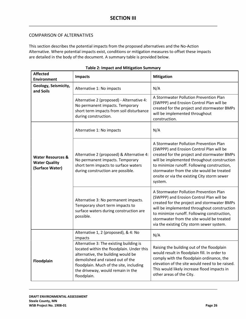
SECTION III
DRAFT ENVIRONMENTAL ASSESSMENT Steele County, MN WSB Project No. 1908-01 Page 26
COMPARISON OF ALTERNATIVES This section describes the potential impacts from the proposed alternatives and the No-Action Alternative. Where potential impacts exist, conditions or mitigation measures to offset these impacts are detailed in the body of the document. A summary table is provided below.
Table 2: Impact and Mitigation Summary Affected Environment Impacts Mitigation
Geology, Seismicity, and Soils Alternative 1: No impacts N/A
Geology, Seismicity, and Soils
Alternative 2 (proposed) - Alternative 4: No permanent impacts. Temporary short term impacts from soil disturbance during construction.
A Stormwater Pollution Prevention Plan (SWPPP) and Erosion Control Plan will be created for the project and stormwater BMPs will be implemented throughout construction.
Water Resources & Water Quality (Surface Water)
Alternative 1: No impacts N/A
Water Resources & Water Quality (Surface Water)
Alternative 2 (proposed) & Alternative 4: No permanent impacts. Temporary short term impacts to surface waters during construction are possible.
A Stormwater Pollution Prevention Plan (SWPPP) and Erosion Control Plan will be created for the project and stormwater BMPs will be implemented throughout construction to minimize runoff. Following construction, stormwater from the site would be treated onsite or via the existing City storm sewer system.
Water Resources & Water Quality (Surface Water)
Alternative 3: No permanent impacts. Temporary short term impacts to surface waters during construction are possible.
A Stormwater Pollution Prevention Plan (SWPPP) and Erosion Control Plan will be created for the project and stormwater BMPs will be implemented throughout construction to minimize runoff. Following construction, stormwater from the site would be treated via the existing City storm sewer system.
Floodplain Alternative 1, 2 (proposed), & 4: No impacts N/A
Floodplain
Alternative 3: The existing building is located within the floodplain. Under this alternative, the building would be demolished and raised out of the floodplain. Much of the site, including the driveway, would remain in the floodplain.
Raising the building out of the floodplain would result in floodplain fill. In order to comply with the floodplain ordinance, the elevation of the site would need to be raised. This would likely increase flood impacts in other areas of the City.
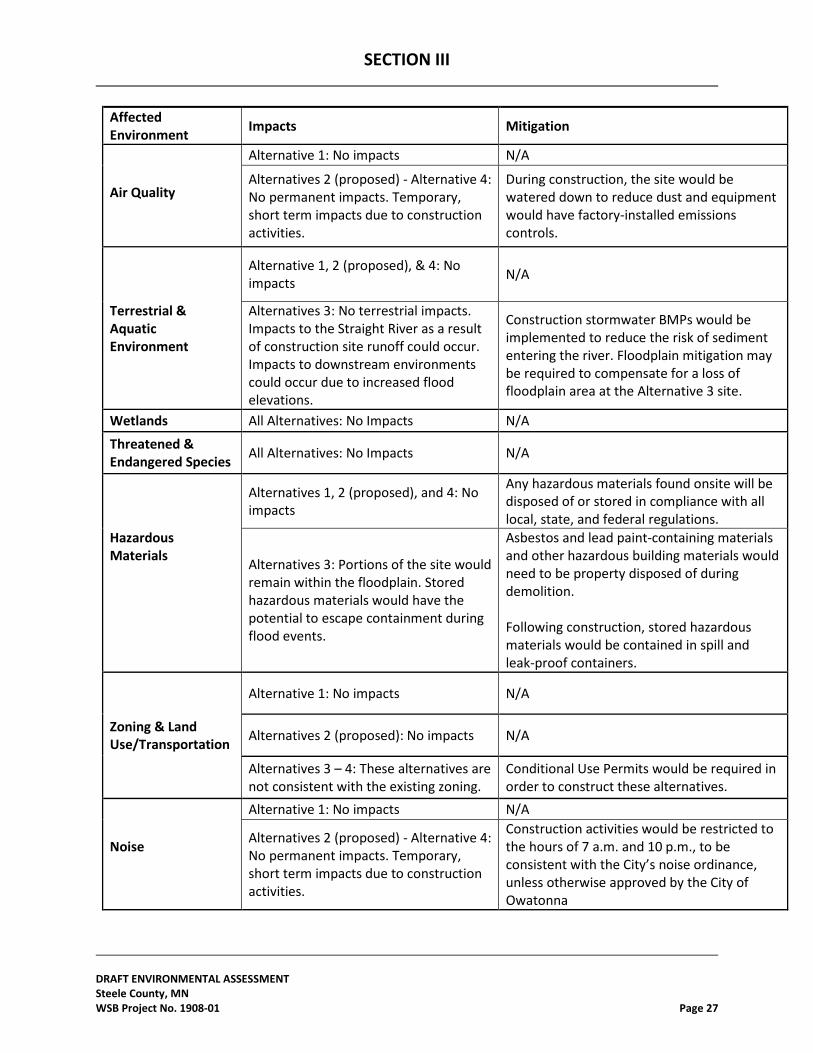
SECTION III
DRAFT ENVIRONMENTAL ASSESSMENT Steele County, MN WSB Project No. 1908-01 Page 27
Affected Environment Impacts Mitigation
Air Quality Alternative 1: No impacts N/A Air Quality
Alternatives 2 (proposed) - Alternative 4: No permanent impacts. Temporary, short term impacts due to construction activities.
During construction, the site would be watered down to reduce dust and equipment would have factory-installed emissions controls.
Terrestrial & Aquatic Environment
Alternative 1, 2 (proposed), & 4: No impacts N/A
Terrestrial & Aquatic Environment
Alternatives 3: No terrestrial impacts. Impacts to the Straight River as a result of construction site runoff could occur. Impacts to downstream environments could occur due to increased flood elevations.
Construction stormwater BMPs would be implemented to reduce the risk of sediment entering the river. Floodplain mitigation may be required to compensate for a loss of floodplain area at the Alternative 3 site.
Wetlands All Alternatives: No Impacts N/A
Threatened & Endangered Species All Alternatives: No Impacts N/A
Hazardous Materials
Alternatives 1, 2 (proposed), and 4: No impacts
Any hazardous materials found onsite will be disposed of or stored in compliance with all local, state, and federal regulations.
Hazardous Materials Alternatives 3: Portions of the site would
remain within the floodplain. Stored hazardous materials would have the potential to escape containment during flood events.
Asbestos and lead paint-containing materials and other hazardous building materials would need to be property disposed of during demolition. Following construction, stored hazardous materials would be contained in spill and leak-proof containers.
Zoning & Land Use/Transportation Alternative 1: No impacts N/A
Zoning & Land Use/Transportation Alternatives 2 (proposed): No impacts N/A
Zoning & Land Use/Transportation
Alternatives 3 – 4: These alternatives are not consistent with the existing zoning.
Conditional Use Permits would be required in order to construct these alternatives.
Noise Alternative 1: No impacts N/A Noise Alternatives 2 (proposed) - Alternative 4:
No permanent impacts. Temporary, short term impacts due to construction activities.
Construction activities would be restricted to the hours of 7 a.m. and 10 p.m., to be consistent with the City’s noise ordinance, unless otherwise approved by the City of Owatonna
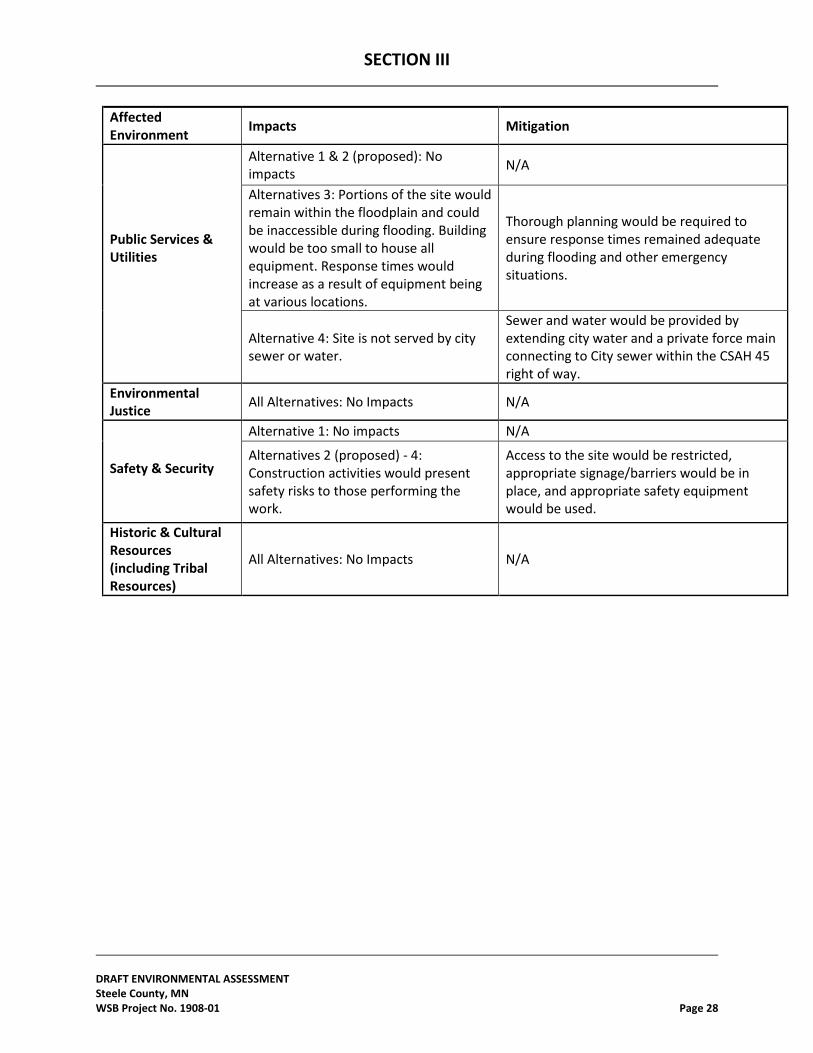
SECTION III
DRAFT ENVIRONMENTAL ASSESSMENT Steele County, MN WSB Project No. 1908-01 Page 28
Affected Environment Impacts Mitigation
Public Services & Utilities
Alternative 1 & 2 (proposed): No impacts N/A
Public Services & Utilities
Alternatives 3: Portions of the site would remain within the floodplain and could be inaccessible during flooding. Building would be too small to house all equipment. Response times would increase as a result of equipment being at various locations.
Thorough planning would be required to ensure response times remained adequate during flooding and other emergency situations.
Public Services & Utilities
Alternative 4: Site is not served by city sewer or water.
Sewer and water would be provided by extending city water and a private force main connecting to City sewer within the CSAH 45 right of way.
Environmental Justice All Alternatives: No Impacts N/A
Safety & Security Alternative 1: No impacts N/A Safety & Security
Alternatives 2 (proposed) - 4: Construction activities would present safety risks to those performing the work.
Access to the site would be restricted, appropriate signage/barriers would be in place, and appropriate safety equipment would be used.
Historic & Cultural Resources (including Tribal Resources)
All Alternatives: No Impacts N/A
SECTION IV
DRAFT ENVIRONMENTAL ASSESSMENT Steele County, MN WSB Project No. 1908-01 Page 29
IV. CUMULATIVE IMPACTS
According to Council on Environmental Quality (CEQ) regulations, cumulative impacts represent the “impact on the environment which results from the incremental impact of the action when added to other past, present, and reasonably foreseeable future actions, regardless of what agency (Federal or non-Federal) or person undertakes such other actions. Cumulative impacts can result from individually minor but collectively significant actions taking place over a period of time (40 C.F.R. § 1508.7).” In accordance with NEPA and to the extent reasonable and practical, this EA considered the combined effect of the Proposed Action Alternative and other actions occurring or proposed in the vicinity of the proposed project area. Alternative 1: No Action – There would be no cumulative impacts under the No Action Alternative. Alternative 2: New Site and Facility (Proposed Action) – The Proposed Action would result in impacts to the immediate development area including soil disturbance, farmland impacts, and an increase in stormwater runoff. Best Management Practices will be utilized in order to minimize impacts resulting from soil disturbance and stormwater runoff. The Farmland Impacts will be vetted through the USDA, but mitigation is not anticipated. There are no ongoing projects occurring or projects proposed within the vicinity of the Proposed Action that would combine with the Proposed Action to create cumulative impacts.
Alternative 3: Repair/Elevate Existing Facility – This alternative would result in temporary, short-term impacts to the soil and result in a building site that remained partially within the floodplain. Best Management Practices will be utilized in order to minimize impacts resulting from soil disturbance. The land surrounding the existing building is fully developed. There are no ongoing or proposed projects that would combine with this alternative to create cumulative impacts. Alternative 4: Purchase Vacant Building and Renovate – Alternative 4 would involve renovating an existing building. Temporary, short-term impacts to the soil are anticipated. Best Management Practices will be utilized in order to minimize impacts resulting from soil disturbance. There are no ongoing or proposed projects that would combine with Alternative 4 to create cumulative impacts.
SECTION V
DRAFT ENVIRONMENTAL ASSESSMENT Steele County, MN WSB Project No. 1908-01 Page 30
V. PUBLIC PARTICIPATION
Information regarding the project is available on Steele County’s website at: http://www.co.steele.mn.us/departments/transportation(highway)/highway_operations_complex.html. This site includes background and up-to-date information on the progress of the project. In 2010, shortly after the DR 1941 Flood Event, the County Board began discussing options and making decisions on the process and project. This decision making continues today. In early 2011, the County Board set up a Facilities Committee made up of appropriate county staff and two County Commissioners. The Facility committee was tasked with guiding the project development process. All meetings were open to the public and the local newspaper reporters were invited to all Facilities Committee meetings. A summary of County Board meeting actions is provided in Appendix E. A taskforce made up of community members was also formed to provide input from the community. The task force included five members of the community and one alternate. The taskforce met monthly from January through April 2013 and again in June, July, and September 2013 to review the proposed project and alternatives. In addition to the community taskforce, meetings open to the general public have also been held for this project. A summary of meetings that were held for this project and records of public support can be found in Appendix E.
SECTION VII
DRAFT ENVIRONMENTAL ASSESSMENT Steele County, MN WSB Project No. 1908-01 Page 31
VI. AGENCY COORDINATION, PERMITS AND CONDITIONS
The following agencies and organizations were consulted or were contacted to request project review during the preparation of this EA. Responses received to date are included in Appendix B.
In accordance with applicable local, State, and Federal regulations the applicant would be responsible for acquiring any necessary permits prior to commencing construction at the proposed project area. The following permits and approvals may be required prior to construction:
1. The Corps of Engineers was contacted in early 2012 to determine if the project fell under their jurisdiction. On April 27, 2012, it was determined that since there was no work being done in a navigable water of the United States, and no dredging or fill material being discharged into any water of the U.S., no permit would be required from the USACE for this project.
2. On April 12, 2012, the Department of Natural Resources confirmed that no public
waters permit would be needed.
3. The Soil and Water Conservation District determined that no WCA jurisdictional wetlands were found on site on April 9, 2012.
4. Preliminary searching through the U.S. Fish & Wildlife Service on July 19, 2012 and
August 20, 2014 showed that the northern long-eared bat and dwarf trout lily are both present in Steele County. However, based on the site properties, both of these species are highly unlikely to be present.
5. On July 16, 2012, the DNR was contacted to review the project area for rare features. A
finding of “no effect” was received on July 25, 2012. Correspondence with the DNR on October 5, 2015 confirmed that the information received in 2012 is still valid.
6. In August 2015, a Phase I Cultural Resources Assessment was completed for the Project
area. The results were submitted to FEMA for review under Section 106 of the National Historic Preservation Act. The FEMA concluded that the project would have no effect on cultural resources.
7. City of Owatonna permits for Building, Plumbing, Electrical, and Mechanical will be
required for the project. Environmental Conditions
1. Appropriate construction BMPs will be implemented to minimize soil erosion. The measures will be implemented, installed, and maintained as required by the SWPPP Permit and meeting local erosion control standards. The measures may include, but are not limited to,
SECTION VII
DRAFT ENVIRONMENTAL ASSESSMENT Steele County, MN WSB Project No. 1908-01 Page 32
minimizing the disturbed area, maintaining vegetative cover, inlet protection, stabilized construction entrances, silt fence, and erosion mat.
2. Measures will be taken to reduce the potential for temporary air quality impacts during construction, including keeping fuel-burning equipment running time to a minimum, minimizing open construction areas, and watering open construction areas to control dust when necessary.
3. To mitigate for potential impacts to the terrestrial and aquatic environment, native vegetation will be planted throughout the disturbed area. If hazardous materials are encountered during construction, materials will be handled and disposed of in accordance with all applicable rules and regulations.
4. To minimize the risks to safety and human health, all construction activities will be performed using qualified personnel trained in the proper use of the appropriate equipment including all appropriate safety precautions; additionally, all activities would be conducted in a safe manner in accordance with the standards specified in the OSHA regulations.
5. Equipment will be maintained in good working order to minimize noise and pollution. 6. If any human or archeological remains are encountered during construction, work at the site
would be stopped immediately and FEMA and the Minnesota SHPO would be contacted by the sub-recipient immediately.
7. If deviations from the proposed scope of work result in substantial design changes, including the need for additional ground disturbance, additional removal of vegetation, or in any other unanticipated changes to the physical environment, the Recipient must contact FEMA, and a re-evaluation under NEPA and other applicable environmental laws will be conducted by FEMA.
8. The applicant is responsible for obtaining and complying with all required local, State and Federal permits and approvals.
9. Construction activities would be restricted to the hours of 7:00 AM to 10:00 PM to be consistent with City of Owatonna noise ordinance.
10. Any hazardous materials found onsite will be disposed of or stored in compliance with all local, state, and federal regulations.
11. No spoil material removed from construction area may be stored or disposed of in a regulated floodplain or wetland area.
No spoil material removed from construction area may be stored or disposed of in a regulated floodplain or wetland area.
SECTION VII
DRAFT ENVIRONMENTAL ASSESSMENT Steele County, MN WSB Project No. 1908-01 Page 33
VII. REFERENCES
FEMA Flood Map Service Center | Search By Address (FEMA Flood Map Service Center | Search By Address) https://msc.fema.gov/portal/search?AddressQuery=Steele%20County%2C%20Minnesota. Accessed 9/23/2015.
Minnesota Department of Natural Resources Public Waters Inventory (PWI) Maps (Public
Waters Inventory Maps). http://www.dnr.state.mn.us/waters/watermgmt_section/pwi/maps.html. Accessed 11/20/2014.
Minnesota Geological Survey. 1979. Earthquake History of Minnesota. Report of Investigations
23. ISSN 0076-9177. Minnesota Pollution Control Agency (What's in My Neighborhood). http://www.pca.state.mn.us/index.php/data/wimn-whats-in-my-neighborhood/whats-in-my-
neighborhood.html. Accessed 10/14/2015. National Wetlands Inventory Update (National Wetlands Inventory project: Minnesota DNR).
http://www.dnr.state.mn.us/eco/wetlands/nwi_proj.html. Accessed 11/20/2014. Soil Survey Staff, Natural Resources Conservation Service, United States Department of
Agriculture. Web Soil Survey, Minnesota. http://websoilsurvey.nrcs.usda.gov/. Accessed 9/9/2015.
U.S. Census Bureau. 2010. American Fact Finder. http://factfinder.census.gov. Accessed
10/20/2015. What's In My Neighborhood Agricultural Interactive Mapping (What's In My Neighborhood
Agricultural Interactive Mapping). http://www.mda.state.mn.us/chemicals/spills/incidentresponse/neighborhood.aspx. Accessed 10/14/2015.
SECTION VIII
DRAFT ENVIRONMENTAL ASSESSMENT Steele County, MN WSB Project No. 1908-01 Page 34
VIII. LIST OF PREPARERS
Preparation and quality control review of the Draft and Final EA: Alison Harwood, WSB & Associates, Inc. Anita Benson, Steele County Nicholas Mueller, Regional Environmental Officer, FEMA Region V

APPENDIX A
DRAFT ENVIRONMENTAL ASSESSMENT Steele County, MN WSB Project No. 1908-01 APPENDIX A
Figures
APPENDIX B
DRAFT ENVIRONMENTAL ASSESSMENT Steele County, MN WSB Project No. 1908-01 APPENDIX B
Agency Coordination
APPENDIX C
DRAFT ENVIRONMENTAL ASSESSMENT Steele County, MN WSB Project No. 1908-01 APPENDIX C
Flood Insurance Rate Map
APPENDIX D
DRAFT ENVIRONMENTAL ASSESSMENT Steele County, MN WSB Project No. 1908-01 APPENDIX D
Grading and Erosion Control Plan

APPENDIX E
DRAFT ENVIRONMENTAL ASSESSMENT Steele County, MN WSB Project No. 1908-01 APPENDIX E
Meeting Summary