Embed Size (px)
Citation preview
Status Survey of Ouachita Rock Pocketbook, Arkansia wheeleri Ortmann and
Walker 1912, Scaleshell, Leptodea leptodon (Rafinesque 1820), and
Rabbitsfoot, Quadrula c. cylindrica (Say 1817),
in the Little River Basin, Arkansas
Jennifer Bouldin1, William R. Posey II
2, and John L. Harris
1
1Arkansas State University, Department of Biological Sciences, P.O. Box 599, State
University AR 72467, 2Arkansas Game and Fish Commission, Perrytown, AR
Final Report
30 September 2013
TABLE OF CONTENTS
Introduction .............................................................................................................. 1
Methods ..................................................................................................................... 1
Results ....................................................................................................................... 2
Cossatot River ............................................................................................................ 2
Saline River ................................................................................................................ 3
Rolling Fork of Little River ....................................................................................... 3
Discussion .................................................................................................................. 4
Acknowledgements................................................................................................... 5
Literature Cited ........................................................................................................ 6
Table 1 ........................................................................................................................ 7
Table 1 ........................................................................................................................ 8
Table 2 ......................................................................................................................13
Table 3 ......................................................................................................................17
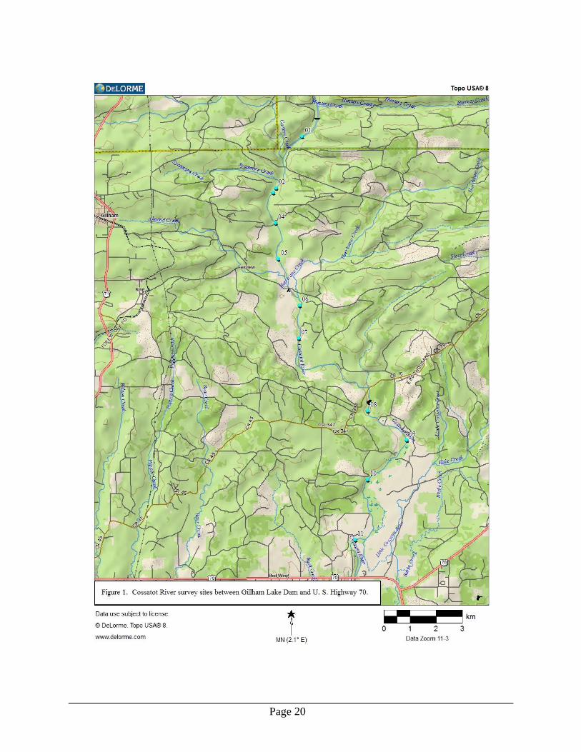
Figure 1 ....................................................................................................................20
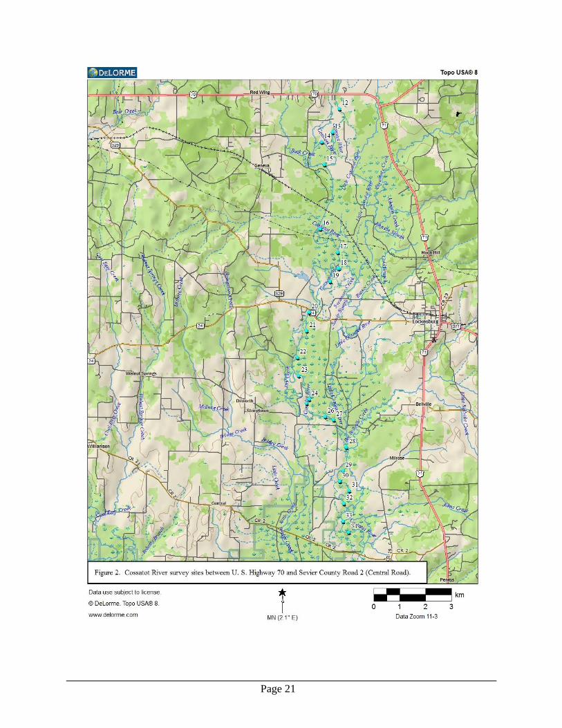
Figure 2 ....................................................................................................................21
Figure 3 ....................................................................................................................22
Figure 4 ....................................................................................................................23
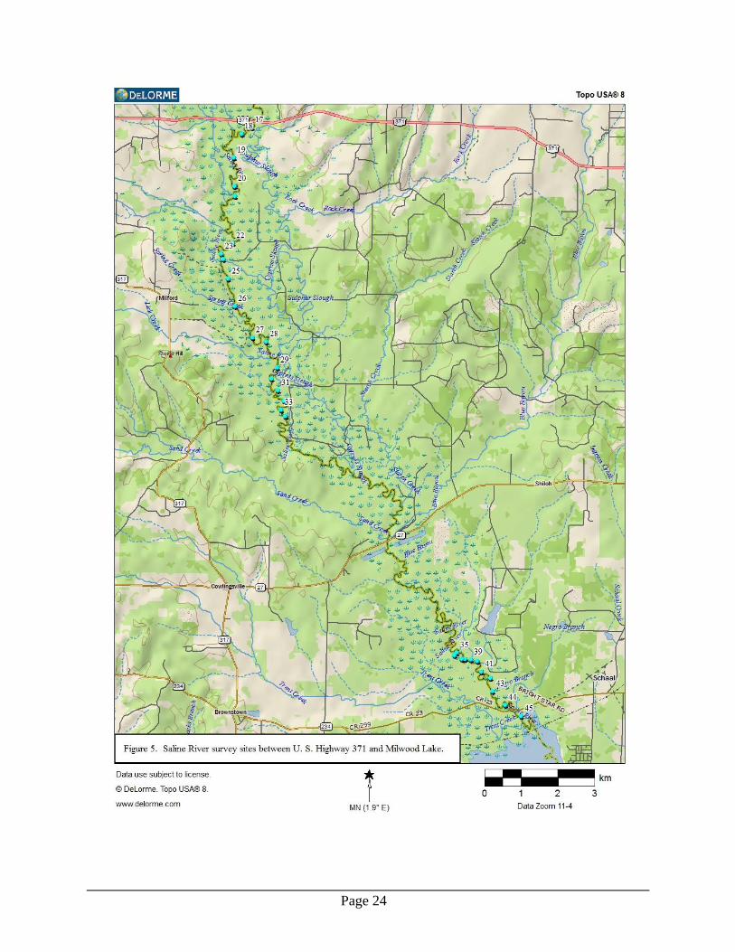
Figure 5 ....................................................................................................................24
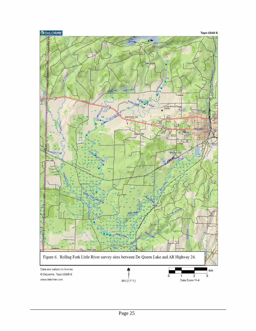
Figure 6 ....................................................................................................................25
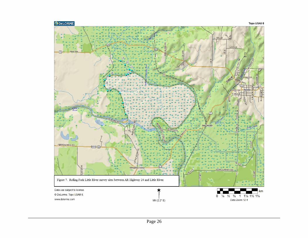
Figure 7 ....................................................................................................................26
Appendix A
Page 1
Status Survey of Ouachita Rock Pocketbook, Arkansia wheeleri Ortmann and
Walker 1912, Scaleshell, Leptodea leptodon (Rafinesque 1820), and Rabbitsfoot,
Quadrula c. cylindrica (Say 1817), in the Little River Basin, Arkansas
Introduction
Both Arkansia wheeleri and Leptodea leptodon are extremely rare species globally and
within Arkansas, and the vast majority of occurrences for Quadrula c. cylindrica in
Arkansas are known from the Ouachita and White River drainages with a few listed for
the Little River (Red River Drainage) (Harris et al. 2010). Surprisingly, there have never
been systematic mussel surveys conducted in major Little River tributaries such as the
Cossatot River, Saline River, and Rolling Fork Little River. This project addresses the
lack of status information for Arkansia wheeleri, Leptodea leptodon, and Quadrula c.
cylindrica in Little River Basin streams (Red River Drainage) that have not been
intensively surveyed for freshwater mussels in the past.
In addition, there are numerous mussel taxa which likely occur in the Cossatot, Saline,
and Rolling Fork rivers that are not federally protected but that are currently listed as S1,
S2 or S3 by the Arkansas Natural Heritage Commission. State ranking definitions
(ANHC 2013) include: S1 (critically imperiled) - often 5 or fewer populations, very steep
declines or other factors making it vulnerable to extirpation; S2 (imperiled) - very few
populations (often 20 or fewer), steep declines or other factors making it vulnerable to
extirpation; S3 (vulnerable) - relatively few populations (often 80 or fewer), recent and
widespread declines or other factors making it vulnerable to extirpation. Information
regarding distribution and population status is required for conservation management of
these species in the Little River Basin. These species include Arcidens confragosus (S3),
Ellipsaria lineolata (S3), Lampsilis abrupta (S2, G2), Lampsilis hydiana (S3), L. satura
(S2), L. siliquoidea (S3), L. sp. B cf hydiana (S2?), Lasmigona costata (S3), Obovaria
arkansasensis (S2, G1G2), O. olivaria (S3), Pleurobema cordatum (S2), P. riddellii
(S2?) P. rubrum (S2, G2), P. sintoxia (S3), Ptychobranchus occidentalis (S3), Quadrula
apiculata (S2), Strophitus undulatus (S3), Toxolasma texasense (S3), Truncilla
donaciformis (S3), and Villosa lienosa (S3) (Harris, et al. 2010, ANHC 2013).
Methods
Each river segment was navigated by boat, canoe or pedestrian means. A jon-boat with
jet-prop outboard motor was used to access the downstream limits of each river and
motor as far upstream as possible before systematically working sample sites
downstream. Upstream reaches of each river were canoed from the upstream study limits
downstream to the limits of jon-boat access. Approximately 200 river kilometers (rkm)
[ca. 125 river miles (rmi)] were assessed during this project. Stream segments assessed
Page 2
included the Cossatot River from Gillham Lake Dam downstream to the confluence with
Little River, the Saline River from U. S. Highway 70 downstream to the influence of
Millwood Lake, and the Rolling Fork of Little River from De Queen Lake to confluence
with Little River.
Good quality sites with evidence of mussel assemblages (live or dead shell visible) were
time searched using both snorkeling and hookah dive techniques. In addition,
depositional areas (gravel bars, overflow secondary channels, vegetated channels) were
searched for fresh dead shells. For specimens of Quadrula cylindrica, length, height, and
width dimensions were measured to the nearest 0.1 mm with a Mitutoyo digital caliper,
and the sex was determined when possible. All mussels encountered were identified to
species, recorded on site specific data sheets that included GPS site coordinates, and the
mussels replaced in the substrate. Coordinates were obtained with a Garmin Venture HC
GPS receiver. Voucher specimens were fixed and preserved in absolute ethanol and will
be deposited in the Mollusk Collection, Museum of Zoology, Arkansas State University.
Nomenclature generally follows scientific names used by Harris, et al. (2010). Use of
Toxolasma lividum follows Williams, et al. (2008), and the synonomy of Obovaria
jacksoniana and Villosa arkansasensis as O. arkansasensis follows Inoue et al. (2013).
We also followed Harris, et al. (2004) in listing all specimens in the Lampsilis cardium
clade as L. cardium rather than L. satura.
Results
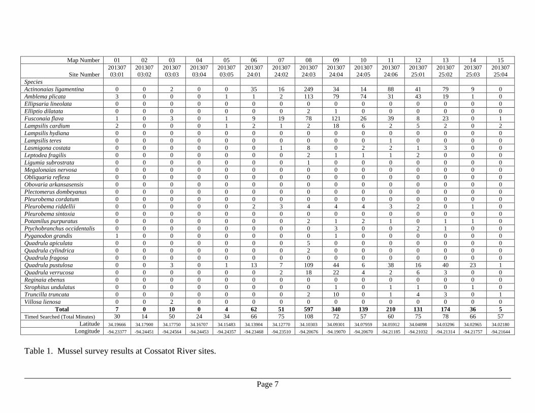
Cossatot River
The Cossatot River was surveyed over 10 field days in 2013 that included May 30-31,
July 1-3, 9-10, 24-25, and September 5. In addition, 5 sites were surveyed August 29,
2003, and they are included in the results. A total of 80 rkm (49.7 rmi) was traversed,
and 24 person-days effort was expended on the Cossatot River. The 77 Cossatot River
sample sites are illustrated in Figures 1-3, and the results are presented in Table 1. The
Cossatot River mussel fauna was comprised of 29 species collected alive distributed
among the 5,537 individuals examined. The Cossatot River mussel assemblage was
dominated by Quadrula pustulosa (35.2% of total mussels) followed by Amblema plicata
(12.9%), Actinonaias ligamentina (11.7%), and Fusconaia flava (11.4%).
One additional species identified as the federally endangered winged mapleleaf
(Quadrula fragosa) was collected in the Cossatot River as a relict shell only. Twenty
specimens (~0.4% of total) of the recently federally listed as threatened Quadrula
cylindrica were encountered at 6 sample sites; however, measurements were taken for
only 17 of the 20, as the other 3 were reproductively displaying females left undisturbed.
Measurements for Q. cylindrica encountered during this project from all rivers are
Page 3
located in Appendix A. No live or dead specimens of Arkansia wheeleri, Lampsilis
abrupta or Leptodea leptodon were encountered in the Cossatot River samples.
One S1, two S2, and four S3 species were found in the Cossatot River. Three specimens
tentatively identified as Pleurobema cordatum (S1) were found at two survey sites. The
S2 species included Pleurobema riddellii (148 specimens, 2.7% of total, 39 of 77 survey
sites) and Quadrula apiculata (36 specimens, 0.7%, 19 of 77 sites). The S3 species
included Lasmigona costata (24 specimens, 0.4%, 12 sites), Ptychobranchus occidentalis
(6 specimens, 0.1%, 3 sites), Strophitus undulatus (19 specimens, 0.3%, 15 sites), and
Villosa lienosa (7 specimens, 0.1%, 5 sites).
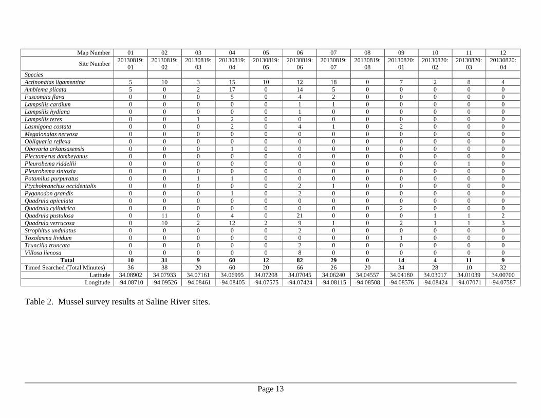
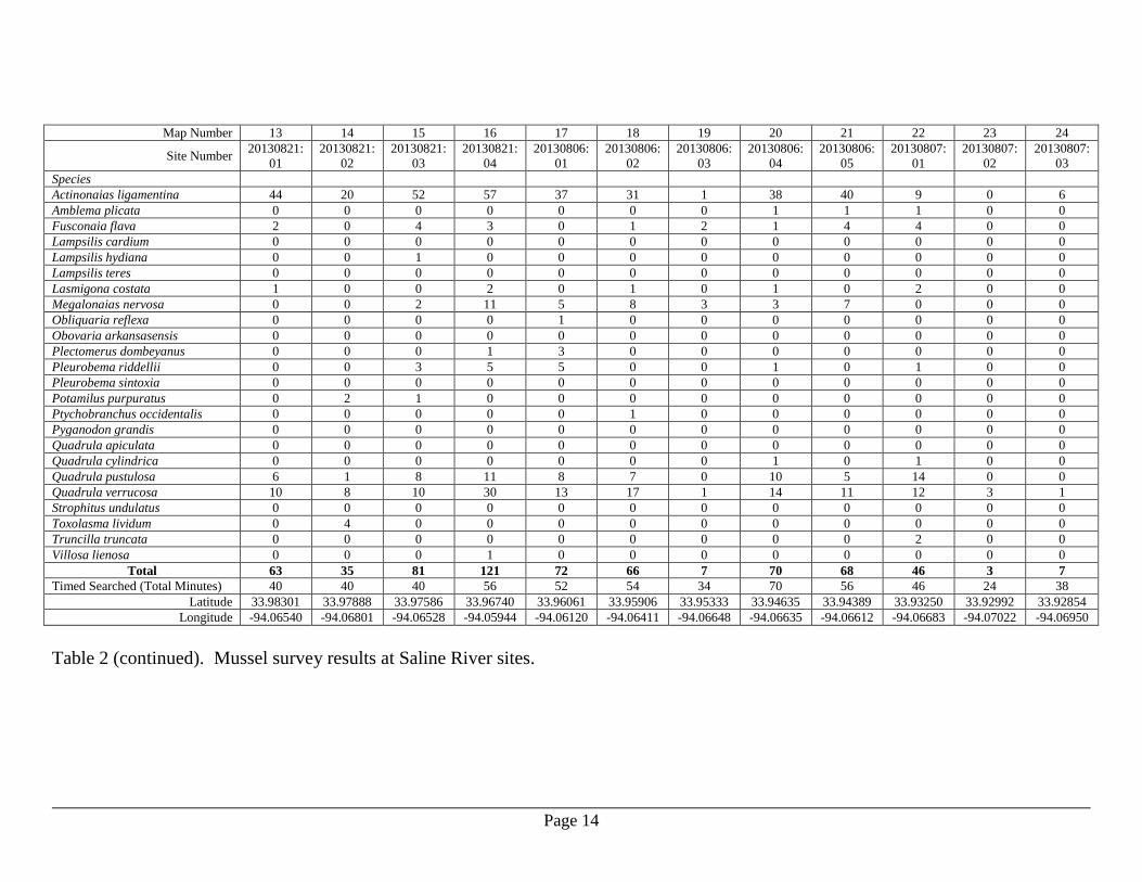
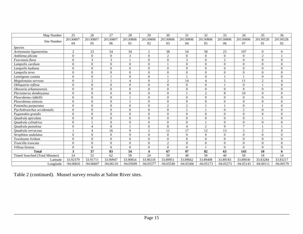
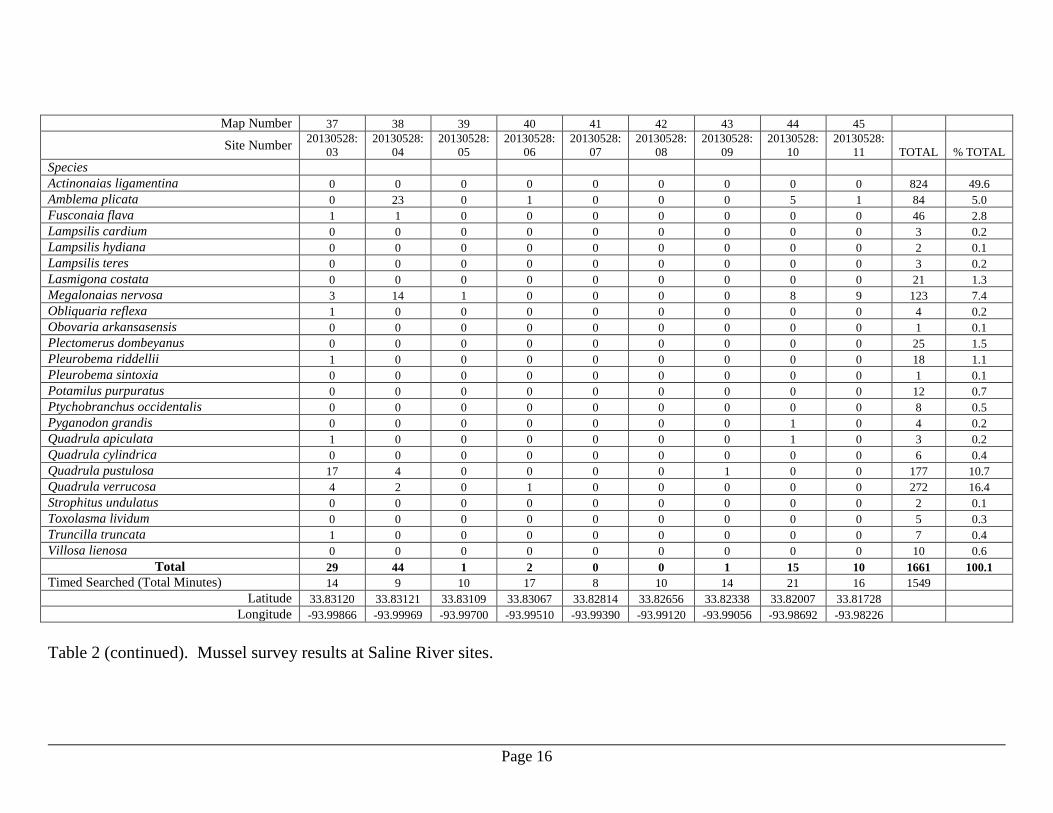
Saline River
The Saline River was sampled over 7 field days in 2013 that included May 28, August 6-
8 and August 19-21. A total of 14 person-days was expended surveying the Saline River,
and approximately 65.1 rkm (40.5 rmi) was assessed. The 45 Saline River sample sites
are illustrated in Figures 4-5, and the results are presented in Table 2. Twenty four
species were identified from the 1,661 specimens examined. Quadrula cylindrica was
represented by 6 specimens (0.4% of total, 5 survey sites), and no individuals of Arkansia
wheeleri, Lampsilis abrupta or Leptodea leptodon were encountered. The Saline River
mussel assemblage was dominated by Actinonaias ligamentina (49.6% of total) followed
by Quadrula verrucosa (16.4%) and Q. pustulosa (10.7%).
Four S2 and five S3 species were collected from the Saline River. The S2 species were
Obovaria arkansasensis (1 specimen, 0.1% of total, 1 site), Pleurobema riddellii (18
specimens, 1.1%, 8 sites), Quadrula apiculata (3 specimens, 0.2%, 3 sites), and
Toxolasma lividum (5 specimens, 0.3%, 2 sites). The S3 species included Lampsilis
hydiana (2 specimens, 0.1%, 2 sites), Lasmigona costata (21 specimens, 1.3%, 14 sites),
Ptychobranchus occidentalis (8 specimens, 0.5%, 6 sites), Strophitus undulatus (2
specimens, 0.1%, 1 site), and Villosa lienosa (10 specimens, 0.6%, 3 sites).
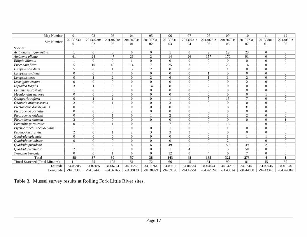
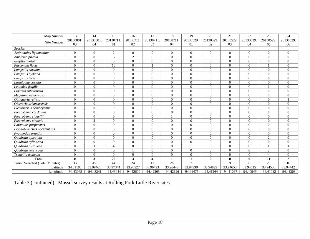
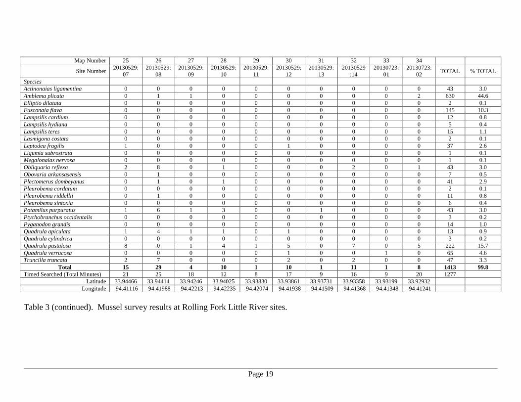
Rolling Fork of Little River
The Rolling Fork of Little River was sampled over 6 field days during 2013 that included
May 29, July 11, July 30-31, and August 1. A total of 16 person-days was utilized to
survey approximately 34.7 rkm (21.6 rmi) and sample the 34 sites illustrated in Figures 6-
7. The 1,413 specimens examined represented 25 species, and Amblema plicata was
numerically dominant (44.6% of total) followed by Quadrula pustulosa (15.7%), and
Fusconaia flava (10.3%) (Table 3). A total of 3 Quadrula cylindrica (0.2% of total, 2
sites) was found, and no individuals of Arkansia wheeleri, Lampsilis abrupta or Leptodea
leptodon were encountered.
Page 4
One S1, three S2 and three S3 species were found in the Rolling Fork of Little River.
Two specimens (0.1% of total mussels) tentatively identified as Pleurobema cordatum
(S1) were encountered at a single site. The S2 species were comprised of Obovaria
arkansasensis (7 specimens, 0.5%, 4 sites), Pleurobema riddellii (11 specimens, 0.8%, 7
sites), and Quadrula apiculata (13 specimens, 0.9%, 9 sites). The S3 species were
represented by Lampsilis hydiana (5 specimens, 0.4 %, 2 sites), Lasmigona costata (2
specimens, 0.1%, 1 site), and Ptychobranchus occidentalis (3 specimens, 0.2%, 3 sites).
Discussion
Quadrula c. cylindrica populations were found in each of the three rivers explored during
this project, and although they represented relatively low percentages of the total mussels
sampled in each river (0.2%-0.4%), each of the populations appears viable and recruiting.
Although no live or dead specimens of the target species Arkansia wheeleri or Leptodea
leptodon were found, we feel there is potential for these species to exist, albeit in low
numbers, in the lower reach of the Cossatot River. A dead Quadrula fragosa shell was
collected at Cossatot River Site 73. We feel the river reach between Sites 56-77 holds the
potential for live A. wheeleri and Q. fragosa given the relatively high species richness
and densities at some of these sites and the similarity of habitat (substrate type, flow
velocity, river morphology) to other rivers inhabited by these species. Future quantitative
sampling should be conducted at 3-5 sites within this reach.
The identification of the S1 species Pleurobema cordatum in Arkansas is problematic due
to convergence of shell morphological characteristics with P. rubrum and P. sintoxia.
Christian et al. (2008) were unable to firmly document P. cordatum in Arkansas due to
lack of useable DNA sequences from topotypic specimens (type locality Ohio River). In
Arkansas, specimens morphologically similar to topotypic P. cordatum occur in the
Ouachita, White, and St. Francis river drainages (Christian et al. 2008, Harris, et al.
2010). Harris et al. (2010) did not include P. cordatum as occurring in the Little River
drainage basin; however, Hayes (2010) had one specimen from the Little River, AR that
assorted with the P. cordatum clade in phylogenetic analysis of the COI gene. We
believe that specimens collected for genetic analysis during this survey will be essential
to resolving the Pleurobema problem west of the Mississippi River, and P. cordatum will
be documented as a component of the Little River Basin mussel community.
Specimens identified as Pleurobema riddellii were a substantial numerical component
(0.8%-2.7%) of each river examined during this project. Christian et al. (2008)
recognized P. riddellii from the Ouachita and Saline rivers based on both molecular and
morphological analyses. Subsequent molecular analyses placed the species in the Little
River (Hayes 2010), and Harris et al. (2010) predicted it would occur in other Red River
drainage streams (i.e. Cossatot and Saline rivers) as well. There appears to be
phylogeographic structuring when comparing molecular data between P. riddellii from
Page 5
the Ouachita and Red River drainages (Hayes 2010). It is possible that P. riddellii from
the Little River drainage is a distinct species from the form in the Ouachita River
drainage. At the very least, they represent biogeographically unique subsets of P.
riddellii.
Habitat instability due to large woody debris dams was commonplace and extensive in
both the Saline River and Rolling Fork Little River survey reaches. Main channels of
both rivers were diverted or subdivided, substantial bank erosion was prominent, and
long reaches of each river extending many river kilometers were unsuitable for mussel
habitation due to substrate instability (silt/sand smothering, loose gravel flows). The
Saline River was so influenced by large woody debris that is was impassable between
Sites 34 and 35 upstream and downstream of AR Highway 27, a distance of
approximately 17 rkm (10.6 rmi). The Rolling Fork Little River was passable but
inhospitable to mussels in the vicinity of AR Highway 24 as the river was divided into
east and west forks with meager water quantity and disturbed physical habitat. It is
unknown whether habitat instability in these two rivers is the result of man-altering
activities such as reservoir construction, timber harvest, land clearing for farming, and/or
transportation infrastructure or the result of natural phenomena centered around soils and
flood events.
Acknowledgements
Thanks to J. H. Seagraves, Arkansas Highway and Transportation Department and D.
Filipek, Arkansas Game and Fish Commission, for assistance in the field. Also thanks to
Sherriff Benny Simmons (Sevier Co.) and Al Wright (John Hendrix Company) for
providing access to the Saline River and Rolling Fork Little River, respectively.
Page 6
Literature Cited
Arkansas Natural Heritage Commission (ANHC). 2013. Rare species of Arkansas. Little
Rock(AR): Arkansas Heritage Program. Available from
http://www.naturalheritage.com/program/rarespecies/. (Accessed: September 30,
2013).
Christian, A. D., J. L. Harris, J. S. Serb, D. L. Hayes, K. Inoue. 2008. Preliminary
analysis for identification, distribution, and conservation status of species of
Pleurobema and Fusconaia in Arkansas. Final Report prepared for Arkansas
Game & Fish Commission, Fisheries Division, Non-game Species Office,
Perrytown, AR. 40p.
Harris, J. L., W. R. Hoeh, A. D. Christian, R. D. Johnson, J. L. Farris, and M. E. Gordon.
2004. Species limits and phylogeography of Lampsilinae (Bivalvia: Unionoida) in
Arkansas with emphasis on species of Lampsilis. Arkansas State University,
Jonesboro. Prepared for the Arkansas Game and Fish Commission and the U. S.
Fish and Wildlife Service. 89 p.
Harris, J. L., W. R. Posey II, C. L. Davidson, J. L. Farris, S. Rogers Oetker, J. N.
Stoeckel, B. G. Crump, M. Scott Barnett, H. C. Martin, M. W. Matthews, J. H.
Seagraves, N. J. Wentz, R. Winterringer, C. Osborne, and A. D. Christian. 2010.
Unionoida (Mollusca: Margaritiferidae, Unionidae) in Arkansas, third status
review. Journal of the Arkansas Academy of Science 63:50-86. Hayes, D. M. 2010. Genetic diversity and distribution of selected freshwater mollusks
(Gastropoda and Bivalvia) from west of the Mississippi River with an emphasis on
Arkansas taxa. Ph.D. dissertation, Department of Biological Sciences, Arkansas
State University, Jonesboro. 130 p. Inoue, K., D. M. Hayes, J. L. Harris, and A. D. Christian. 2013. Phylogenetic and
morphometric analyses reveal ecophenotypic plasticity in freshwater mussels Obovaria jacksoniana and Villosa arkansasensis (Bivalvia: Unionidae). Ecology and Evolution. 3(8), 2670–2683.
Williams, J. D., A. E. Bogan, and J. T. Garner. 2008. Freshwater mussels of Alabama
and the Mobile Basin in Georgia, Mississippi, and Tennessee. University of
Alabama Press, Tuscaloosa. 908 p.
Page 7
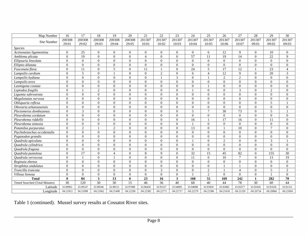
Map Number 01 02 03 04 05 06 07 08 09 10 11 12 13 14 15
Site Number
201307
03:01
201307
03:02
201307
03:03
201307
03:04
201307
03:05
201307
24:01
201307
24:02
201307
24:03
201307
24:04
201307
24:05
201307
24:06
201307
25:01
201307
25:02
201307
25:03
201307
25:04
Species
Actinonaias ligamentina 0 0 2 0 0 35 16 249 34 14 88 41 79 9 0
Amblema plicata 3 0 0 0 1 1 2 113 79 74 31 43 19 1 0
Ellipsaria lineolata 0 0 0 0 0 0 0 0 0 0 0 0 0 0 0
Elliptio dilatata 0 0 0 0 0 0 0 2 1 0 0 0 0 0 0
Fusconaia flava 1 0 3 0 1 9 19 78 121 26 39 8 23 0 1
Lampsilis cardium 2 0 0 0 1 2 1 2 18 6 2 5 2 0 2
Lampsilis hydiana 0 0 0 0 0 0 0 0 0 0 0 0 0 0 0
Lampsilis teres 0 0 0 0 0 0 0 0 0 0 1 0 0 0 0
Lasmigona costata 0 0 0 0 0 0 1 8 0 2 2 1 3 0 0
Leptodea fragilis 0 0 0 0 0 0 0 2 1 1 1 2 0 0 0
Ligumia subrostrata 0 0 0 0 0 0 0 1 0 0 0 0 0 0 0
Megalonaias nervosa 0 0 0 0 0 0 0 0 0 0 0 0 0 0 0
Obliquaria reflexa 0 0 0 0 0 0 0 0 0 0 0 0 0 0 0
Obovaria arkansasensis 0 0 0 0 0 0 0 0 0 0 0 0 0 0 0
Plectomerus dombeyanus 0 0 0 0 0 0 0 0 0 0 0 0 0 0 0
Pleurobema cordatum 0 0 0 0 0 0 0 0 0 0 0 0 0 0 0
Pleurobema riddellii 0 0 0 0 0 2 3 4 4 4 3 2 0 1 0
Pleurobema sintoxia 0 0 0 0 0 0 0 0 0 0 0 0 0 0 0
Potamilus purpuratus 0 0 0 0 0 0 0 2 1 2 1 0 1 1 0
Ptychobranchus occidentalis 0 0 0 0 0 0 0 0 3 0 0 2 1 0 0
Pyganodon grandis 1 0 0 0 0 0 0 0 1 0 0 0 0 0 0
Quadrula apiculata 0 0 0 0 0 0 0 5 0 0 0 0 0 0 0
Quadrula cylindrica 0 0 0 0 0 0 0 2 0 0 0 0 0 0 0
Quadrula fragosa 0 0 0 0 0 0 0 0 0 0 0 0 0 0 0
Quadrula pustulosa 0 0 3 0 1 13 7 109 44 6 38 16 40 23 1
Quadrula verrucosa 0 0 0 0 0 0 2 18 22 4 2 6 3 0 0
Reginaia ebenus 0 0 0 0 0 0 0 0 0 0 0 0 0 0 0
Strophitus undulatus 0 0 0 0 0 0 0 0 1 0 1 1 0 1 0
Truncilla truncata 0 0 0 0 0 0 0 2 10 0 1 4 3 0 1
Villosa lienosa 0 0 2 0 0 0 0 0 0 0 0 0 0 0 0
Total 7 0 10 0 4 62 51 597 340 139 210 131 174 36 5
Timed Searched (Total Minutes) 30 14 50 24 34 66 75 108 72 57 60 75 78 66 57
Latitude 34.19666 34.17900 34.17750 34.16707 34.15483 34.13904 34.12770 34.10303 34.09301 34.07959 34.05912 34.04098 34.03296 34.02965 34.02180
Longitude -94.23377 -94.24451 -94.24564 -94.24453 -94.24357 -94.23468 -94.23510 -94.20676 -94.19070 -94.20670 -94.21185 -94.21032 -94.21314 -94.21757 -94.21644
Table 1. Mussel survey results at Cossatot River sites.
Page 8
Map Number 16 17 18 19 20 21 22 23 24 25 26 27 28 29 30
Site Number 200308
29:01
200308
29:02
200308
29:03
200308
29:04
200308
29:05
201307
10:01
201307
10:02
201307
10:03
201307
10:04
201307
10:05
201307
10:06
201307
10:07
201307
09:01
201307
09:02
201307
09:03
Species
Actinonaias ligamentina 0 25 0 0 0 0 0 0 0 6 12 9 0 10 0
Amblema plicata 0 19 0 0 0 4 0 0 57 11 19 14 0 22 9
Ellipsaria lineolata 0 0 0 0 0 0 0 0 0 0 0 0 0 0 0
Elliptio dilatata 0 0 0 0 0 0 0 0 0 0 0 0 0 0 0
Fusconaia flava 0 11 0 5 0 11 1 0 24 5 17 12 1 23 4
Lampsilis cardium 0 5 0 1 0 0 2 0 6 4 12 9 0 20 3
Lampsilis hydiana 0 0 0 0 0 0 1 3 0 1 2 2 0 0 0
Lampsilis teres 0 0 0 0 0 0 0 0 0 0 0 0 0 0 0
Lasmigona costata 0 0 0 0 0 0 0 0 0 1 0 0 0 0 0
Leptodea fragilis 0 1 2 0 0 0 0 0 1 0 0 3 0 2 0
Ligumia subrostrata 0 0 0 0 0 0 0 0 0 0 0 0 0 0 0
Megalonaias nervosa 0 0 0 0 0 0 0 0 0 0 0 0 0 0 0
Obliquaria reflexa 0 0 0 0 0 0 0 0 0 0 0 0 0 5 1
Obovaria arkansasensis 0 0 0 0 0 0 0 0 0 0 0 0 0 0 0
Plectomerus dombeyanus 0 3 0 0 0 0 0 0 5 7 30 73 0 5 1
Pleurobema cordatum 0 0 0 0 0 0 0 0 0 0 0 0 0 0 0
Pleurobema riddellii 0 0 0 0 0 0 0 0 16 1 17 16 0 11 0
Pleurobema sintoxia 0 0 0 0 0 0 0 0 1 0 0 0 0 0 0
Potamilus purpuratus 0 2 1 2 0 0 0 0 13 0 1 10 0 7 0
Ptychobranchus occidentalis 0 0 0 0 0 0 0 0 0 0 0 0 0 0 0
Pyganodon grandis 0 0 0 0 0 0 0 0 0 0 0 0 0 0 0
Quadrula apiculata 0 0 0 0 0 0 0 0 1 0 2 0 0 3 1
Quadrula cylindrica 0 0 0 0 0 0 0 0 0 0 0 0 0 0 0
Quadrula fragosa 0 0 0 0 0 0 0 0 0 0 0 0 0 0 0
Quadrula pustulosa 0 17 0 4 0 8 9 0 32 15 45 82 0 155 30
Quadrula verrucosa 0 1 0 1 0 0 0 0 11 0 10 7 0 13 19
Reginaia ebenus 0 0 0 0 0 0 0 0 0 0 0 0 0 0 0
Strophitus undulatus 0 0 0 0 0 0 0 0 0 0 1 1 0 0 0
Truncilla truncata 0 0 0 0 0 0 3 0 0 2 1 4 0 5 2
Villosa lienosa 0 0 0 0 0 0 0 0 1 2 0 0 0 1 0
Total 0 84 3 13 0 23 16 3 168 55 169 242 1 282 70
Timed Searched (Total Minutes) 30 120 30 30 15 46 36 40 68 40 44 78 30 60 44
Latitude 33.99965 33.99147 33.98546 33.98151 33.97088 33.96450 33.95527 33.94895 33.94088 33.93950 33.93482 33.93377 33.92426 33.91626 33.91251
Longitude -94.21812 94.21098 -94.21062 -94.21408 -94.22290 -94.22382 -94.22771 -94.22717 -94.22279 -94.22386 -94.21618 -94.21259 -94.20734 -94.20866 -94.21004
Table 1 (continued). Mussel survey results at Cossatot River sites.
Page 9
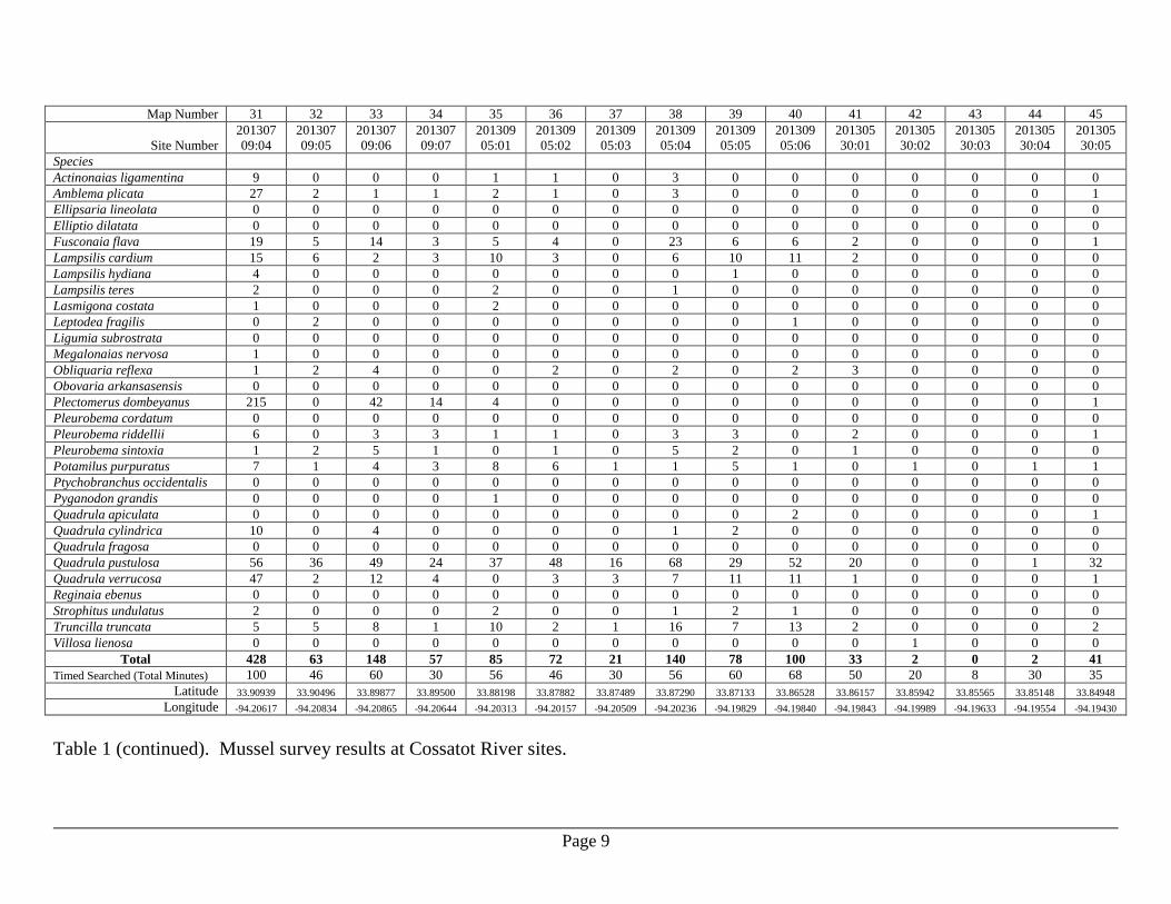
Map Number 31 32 33 34 35 36 37 38 39 40 41 42 43 44 45
Site Number
201307
09:04
201307
09:05
201307
09:06
201307
09:07
201309
05:01
201309
05:02
201309
05:03
201309
05:04
201309
05:05
201309
05:06
201305
30:01
201305
30:02
201305
30:03
201305
30:04
201305
30:05
Species
Actinonaias ligamentina 9 0 0 0 1 1 0 3 0 0 0 0 0 0 0
Amblema plicata 27 2 1 1 2 1 0 3 0 0 0 0 0 0 1
Ellipsaria lineolata 0 0 0 0 0 0 0 0 0 0 0 0 0 0 0
Elliptio dilatata 0 0 0 0 0 0 0 0 0 0 0 0 0 0 0
Fusconaia flava 19 5 14 3 5 4 0 23 6 6 2 0 0 0 1
Lampsilis cardium 15 6 2 3 10 3 0 6 10 11 2 0 0 0 0
Lampsilis hydiana 4 0 0 0 0 0 0 0 1 0 0 0 0 0 0
Lampsilis teres 2 0 0 0 2 0 0 1 0 0 0 0 0 0 0
Lasmigona costata 1 0 0 0 2 0 0 0 0 0 0 0 0 0 0
Leptodea fragilis 0 2 0 0 0 0 0 0 0 1 0 0 0 0 0
Ligumia subrostrata 0 0 0 0 0 0 0 0 0 0 0 0 0 0 0
Megalonaias nervosa 1 0 0 0 0 0 0 0 0 0 0 0 0 0 0
Obliquaria reflexa 1 2 4 0 0 2 0 2 0 2 3 0 0 0 0
Obovaria arkansasensis 0 0 0 0 0 0 0 0 0 0 0 0 0 0 0
Plectomerus dombeyanus 215 0 42 14 4 0 0 0 0 0 0 0 0 0 1
Pleurobema cordatum 0 0 0 0 0 0 0 0 0 0 0 0 0 0 0
Pleurobema riddellii 6 0 3 3 1 1 0 3 3 0 2 0 0 0 1
Pleurobema sintoxia 1 2 5 1 0 1 0 5 2 0 1 0 0 0 0
Potamilus purpuratus 7 1 4 3 8 6 1 1 5 1 0 1 0 1 1
Ptychobranchus occidentalis 0 0 0 0 0 0 0 0 0 0 0 0 0 0 0
Pyganodon grandis 0 0 0 0 1 0 0 0 0 0 0 0 0 0 0
Quadrula apiculata 0 0 0 0 0 0 0 0 0 2 0 0 0 0 1
Quadrula cylindrica 10 0 4 0 0 0 0 1 2 0 0 0 0 0 0
Quadrula fragosa 0 0 0 0 0 0 0 0 0 0 0 0 0 0 0
Quadrula pustulosa 56 36 49 24 37 48 16 68 29 52 20 0 0 1 32
Quadrula verrucosa 47 2 12 4 0 3 3 7 11 11 1 0 0 0 1
Reginaia ebenus 0 0 0 0 0 0 0 0 0 0 0 0 0 0 0
Strophitus undulatus 2 0 0 0 2 0 0 1 2 1 0 0 0 0 0
Truncilla truncata 5 5 8 1 10 2 1 16 7 13 2 0 0 0 2
Villosa lienosa 0 0 0 0 0 0 0 0 0 0 0 1 0 0 0
Total 428 63 148 57 85 72 21 140 78 100 33 2 0 2 41
Timed Searched (Total Minutes) 100 46 60 30 56 46 30 56 60 68 50 20 8 30 35
Latitude 33.90939 33.90496 33.89877 33.89500 33.88198 33.87882 33.87489 33.87290 33.87133 33.86528 33.86157 33.85942 33.85565 33.85148 33.84948
Longitude -94.20617 -94.20834 -94.20865 -94.20644 -94.20313 -94.20157 -94.20509 -94.20236 -94.19829 -94.19840 -94.19843 -94.19989 -94.19633 -94.19554 -94.19430
Table 1 (continued). Mussel survey results at Cossatot River sites.
Page 10
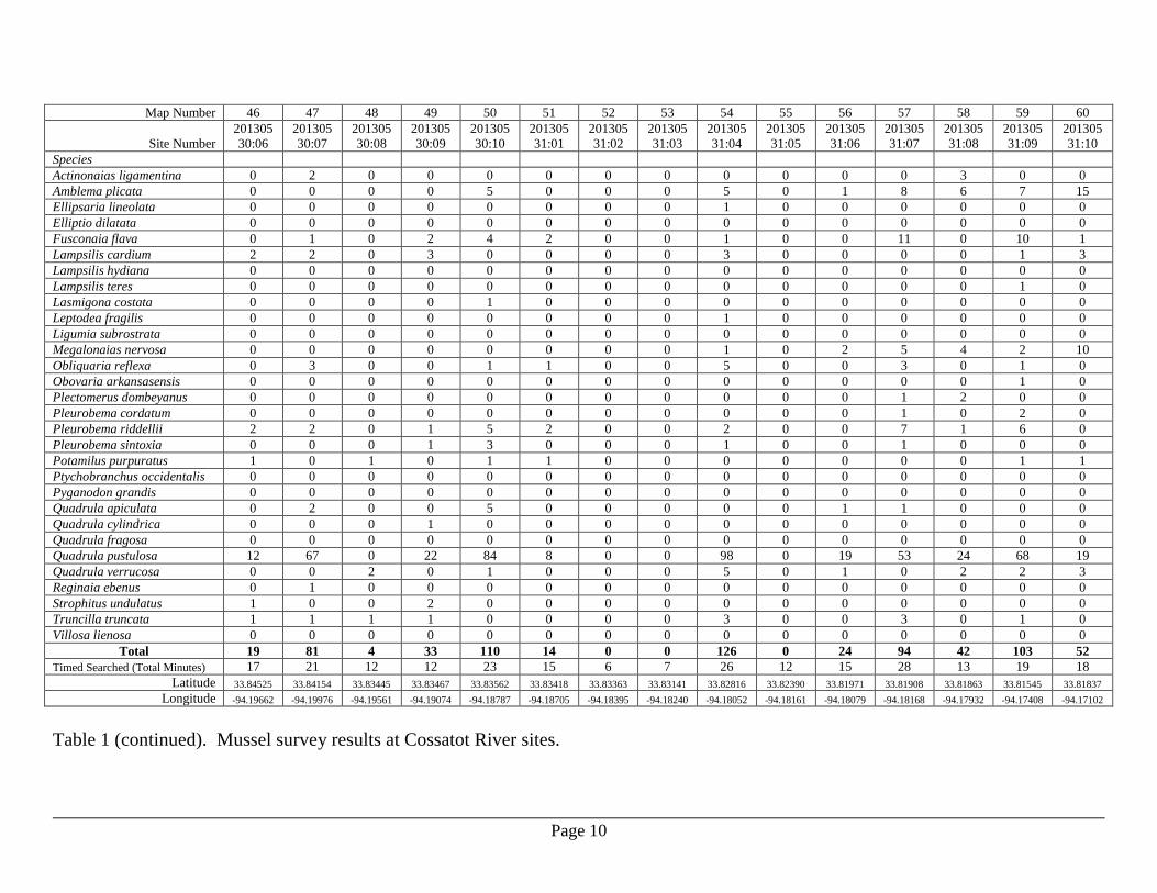
Map Number 46 47 48 49 50 51 52 53 54 55 56 57 58 59 60
Site Number
201305
30:06
201305
30:07
201305
30:08
201305
30:09
201305
30:10
201305
31:01
201305
31:02
201305
31:03
201305
31:04
201305
31:05
201305
31:06
201305
31:07
201305
31:08
201305
31:09
201305
31:10
Species
Actinonaias ligamentina 0 2 0 0 0 0 0 0 0 0 0 0 3 0 0
Amblema plicata 0 0 0 0 5 0 0 0 5 0 1 8 6 7 15
Ellipsaria lineolata 0 0 0 0 0 0 0 0 1 0 0 0 0 0 0
Elliptio dilatata 0 0 0 0 0 0 0 0 0 0 0 0 0 0 0
Fusconaia flava 0 1 0 2 4 2 0 0 1 0 0 11 0 10 1
Lampsilis cardium 2 2 0 3 0 0 0 0 3 0 0 0 0 1 3
Lampsilis hydiana 0 0 0 0 0 0 0 0 0 0 0 0 0 0 0
Lampsilis teres 0 0 0 0 0 0 0 0 0 0 0 0 0 1 0
Lasmigona costata 0 0 0 0 1 0 0 0 0 0 0 0 0 0 0
Leptodea fragilis 0 0 0 0 0 0 0 0 1 0 0 0 0 0 0
Ligumia subrostrata 0 0 0 0 0 0 0 0 0 0 0 0 0 0 0
Megalonaias nervosa 0 0 0 0 0 0 0 0 1 0 2 5 4 2 10
Obliquaria reflexa 0 3 0 0 1 1 0 0 5 0 0 3 0 1 0
Obovaria arkansasensis 0 0 0 0 0 0 0 0 0 0 0 0 0 1 0
Plectomerus dombeyanus 0 0 0 0 0 0 0 0 0 0 0 1 2 0 0
Pleurobema cordatum 0 0 0 0 0 0 0 0 0 0 0 1 0 2 0
Pleurobema riddellii 2 2 0 1 5 2 0 0 2 0 0 7 1 6 0
Pleurobema sintoxia 0 0 0 1 3 0 0 0 1 0 0 1 0 0 0
Potamilus purpuratus 1 0 1 0 1 1 0 0 0 0 0 0 0 1 1
Ptychobranchus occidentalis 0 0 0 0 0 0 0 0 0 0 0 0 0 0 0
Pyganodon grandis 0 0 0 0 0 0 0 0 0 0 0 0 0 0 0
Quadrula apiculata 0 2 0 0 5 0 0 0 0 0 1 1 0 0 0
Quadrula cylindrica 0 0 0 1 0 0 0 0 0 0 0 0 0 0 0
Quadrula fragosa 0 0 0 0 0 0 0 0 0 0 0 0 0 0 0
Quadrula pustulosa 12 67 0 22 84 8 0 0 98 0 19 53 24 68 19
Quadrula verrucosa 0 0 2 0 1 0 0 0 5 0 1 0 2 2 3
Reginaia ebenus 0 1 0 0 0 0 0 0 0 0 0 0 0 0 0
Strophitus undulatus 1 0 0 2 0 0 0 0 0 0 0 0 0 0 0
Truncilla truncata 1 1 1 1 0 0 0 0 3 0 0 3 0 1 0
Villosa lienosa 0 0 0 0 0 0 0 0 0 0 0 0 0 0 0
Total 19 81 4 33 110 14 0 0 126 0 24 94 42 103 52
Timed Searched (Total Minutes) 17 21 12 12 23 15 6 7 26 12 15 28 13 19 18
Latitude 33.84525 33.84154 33.83445 33.83467 33.83562 33.83418 33.83363 33.83141 33.82816 33.82390 33.81971 33.81908 33.81863 33.81545 33.81837
Longitude -94.19662 -94.19976 -94.19561 -94.19074 -94.18787 -94.18705 -94.18395 -94.18240 -94.18052 -94.18161 -94.18079 -94.18168 -94.17932 -94.17408 -94.17102
Table 1 (continued). Mussel survey results at Cossatot River sites.
Page 11
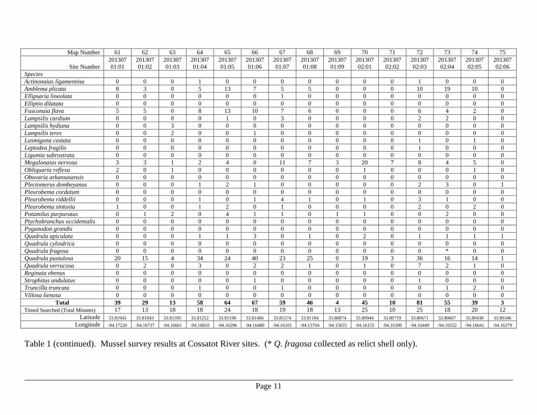
Map Number 61 62 63 64 65 66 67 68 69 70 71 72 73 74 75
Site Number
201307
01:01
201307
01:02
201307
01:03
201307
01:04
201307
01:05
201307
01:06
201307
01:07
201307
01:08
201307
01:09
201307
02:01
201307
02:02
201307
02:03
201307
02:04
201307
02:05
201307
02:06
Species
Actinonaias ligamentina 0 0 0 1 0 0 0 0 0 0 0 1 0 0 0
Amblema plicata 8 3 0 5 13 7 5 5 0 0 0 10 19 10 0
Ellipsaria lineolata 0 0 0 0 0 0 1 0 0 0 0 0 0 0 0
Elliptio dilatata 0 0 0 0 0 0 0 0 0 0 0 0 0 0 0
Fusconaia flava 5 5 0 8 13 10 7 6 0 0 0 6 4 2 0
Lampsilis cardium 0 0 0 0 1 0 3 0 0 0 0 2 2 0 0
Lampsilis hydiana 0 0 3 0 0 0 0 0 0 0 0 0 0 0 0
Lampsilis teres 0 0 2 0 0 1 0 0 0 0 0 0 0 0 0
Lasmigona costata 0 0 0 0 0 0 0 0 0 0 0 1 0 1 0
Leptodea fragilis 0 0 0 0 0 0 0 0 0 0 0 1 0 0 0
Ligumia subrostrata 0 0 0 0 0 0 0 0 0 0 0 0 0 0 0
Megalonaias nervosa 3 3 1 2 4 0 11 7 3 20 7 8 4 5 0
Obliquaria reflexa 2 0 1 0 0 0 0 0 0 1 0 0 0 1 0
Obovaria arkansasensis 0 0 0 0 0 0 0 0 0 0 0 0 0 0 0
Plectomerus dombeyanus 0 0 0 1 2 1 0 0 0 0 0 2 3 0 1
Pleurobema cordatum 0 0 0 0 0 0 0 0 0 0 0 0 0 0 0
Pleurobema riddellii 0 0 0 1 0 1 4 1 0 1 0 3 1 0 0
Pleurobema sintoxia 1 0 0 1 2 0 1 0 0 0 0 2 0 2 0
Potamilus purpuratus 0 1 2 0 4 1 1 0 1 1 0 0 2 0 0
Ptychobranchus occidentalis 0 0 0 0 0 0 0 0 0 0 0 0 0 0 0
Pyganodon grandis 0 0 0 0 0 0 0 0 0 0 0 0 0 0 0
Quadrula apiculata 0 0 0 1 1 3 0 1 0 2 0 1 1 1 1
Quadrula cylindrica 0 0 0 0 0 0 0 0 0 0 0 0 0 0 0
Quadrula fragosa 0 0 0 0 0 0 0 0 0 0 0 0 * 0 0
Quadrula pustulosa 20 15 4 34 24 40 23 25 0 19 3 36 16 14 1
Quadrula verrucosa 0 2 0 3 0 2 2 1 0 1 0 7 2 1 0
Reginaia ebenus 0 0 0 0 0 0 0 0 0 0 0 0 0 0 0
Strophitus undulatus 0 0 0 0 0 1 0 0 0 0 0 1 0 0 0
Truncilla truncata 0 0 0 1 0 0 1 0 0 0 0 0 1 2 0
Villosa lienosa 0 0 0 0 0 0 0 0 0 0 0 0 0 0 0
Total 39 29 13 58 64 67 59 46 4 45 10 81 55 39 3
Timed Searched (Total Minutes) 17 13 18 18 24 18 19 18 13 25 10 25 18 20 12
Latitude 33.81943 33.81943 33.81595 33.81252 33.81190 33.81466 33.81574 33.81184 33.80874 33.80944 33.80719 33.80671 33.80607 33.80438 33.80346
Longitude -94.17220 -94.16737 -94.16661 -94.16810 -94.16296 -94.16480 -94.16101 -94.15704 -94.15655 -94.16155 -94.16390 -94.16449 -94.16552 -94.16641 -94.16379
Table 1 (continued). Mussel survey results at Cossatot River sites. (* Q. fragosa collected as relict shell only).
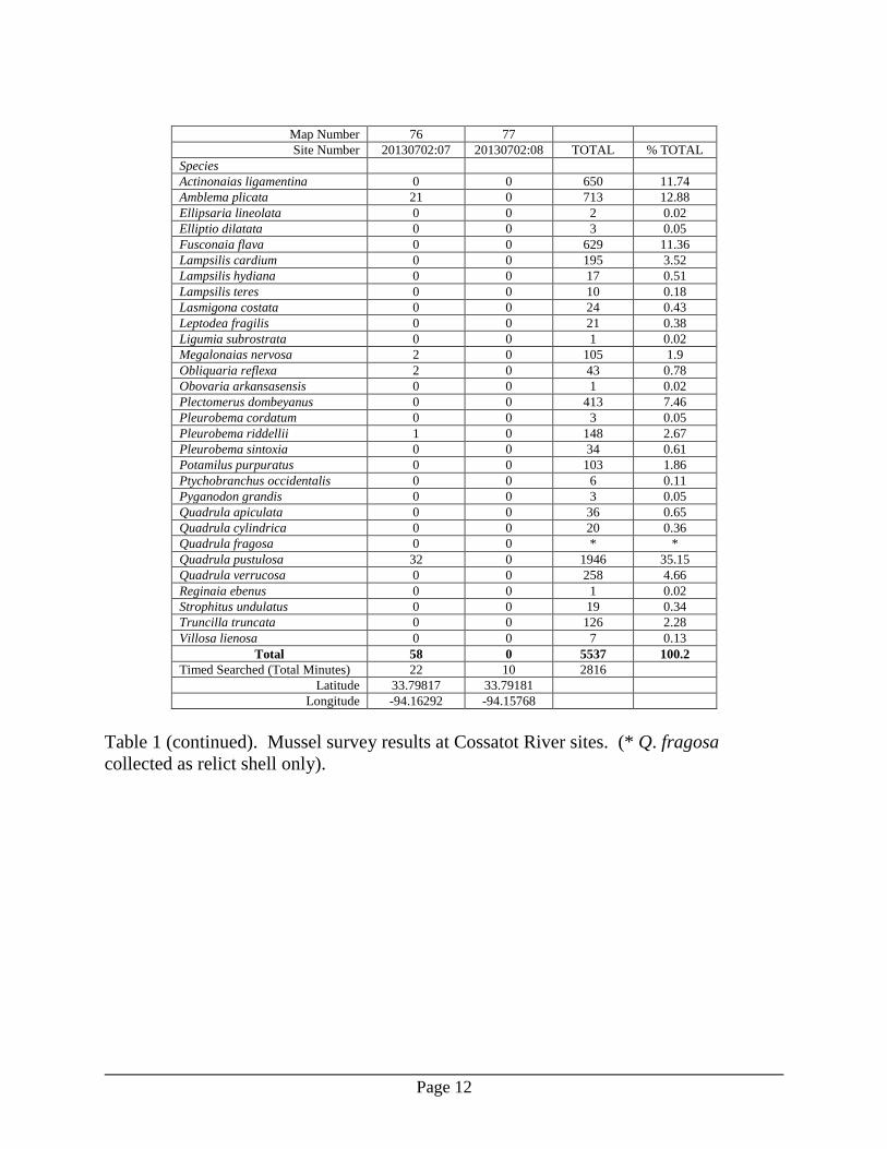
Page 12
Map Number 76 77
Site Number 20130702:07 20130702:08 TOTAL % TOTAL
Species
Actinonaias ligamentina 0 0 650 11.74
Amblema plicata 21 0 713 12.88
Ellipsaria lineolata 0 0 2 0.02
Elliptio dilatata 0 0 3 0.05
Fusconaia flava 0 0 629 11.36
Lampsilis cardium 0 0 195 3.52
Lampsilis hydiana 0 0 17 0.51
Lampsilis teres 0 0 10 0.18
Lasmigona costata 0 0 24 0.43
Leptodea fragilis 0 0 21 0.38
Ligumia subrostrata 0 0 1 0.02
Megalonaias nervosa 2 0 105 1.9
Obliquaria reflexa 2 0 43 0.78
Obovaria arkansasensis 0 0 1 0.02
Plectomerus dombeyanus 0 0 413 7.46
Pleurobema cordatum 0 0 3 0.05
Pleurobema riddellii 1 0 148 2.67
Pleurobema sintoxia 0 0 34 0.61
Potamilus purpuratus 0 0 103 1.86
Ptychobranchus occidentalis 0 0 6 0.11
Pyganodon grandis 0 0 3 0.05
Quadrula apiculata 0 0 36 0.65
Quadrula cylindrica 0 0 20 0.36
Quadrula fragosa 0 0 * *
Quadrula pustulosa 32 0 1946 35.15
Quadrula verrucosa 0 0 258 4.66
Reginaia ebenus 0 0 1 0.02
Strophitus undulatus 0 0 19 0.34
Truncilla truncata 0 0 126 2.28
Villosa lienosa 0 0 7 0.13
Total 58 0 5537 100.2
Timed Searched (Total Minutes) 22 10 2816
Latitude 33.79817 33.79181
Longitude -94.16292 -94.15768
Table 1 (continued). Mussel survey results at Cossatot River sites. (* Q. fragosa
collected as relict shell only).
Page 13
Map Number 01 02 03 04 05 06 07 08 09 10 11 12
Site Number 20130819:
01
20130819:
02
20130819:
03
20130819:
04
20130819:
05
20130819:
06
20130819:
07
20130819:
08
20130820:
01
20130820:
02
20130820:
03
20130820:
04
Species
Actinonaias ligamentina 5 10 3 15 10 12 18 0 7 2 8 4
Amblema plicata 5 0 2 17 0 14 5 0 0 0 0 0
Fusconaia flava 0 0 0 5 0 4 2 0 0 0 0 0
Lampsilis cardium 0 0 0 0 0 1 1 0 0 0 0 0
Lampsilis hydiana 0 0 0 0 0 1 0 0 0 0 0 0
Lampsilis teres 0 0 1 2 0 0 0 0 0 0 0 0
Lasmigona costata 0 0 0 2 0 4 1 0 2 0 0 0
Megalonaias nervosa 0 0 0 0 0 0 0 0 0 0 0 0
Obliquaria reflexa 0 0 0 0 0 0 0 0 0 0 0 0
Obovaria arkansasensis 0 0 0 1 0 0 0 0 0 0 0 0
Plectomerus dombeyanus 0 0 0 0 0 0 0 0 0 0 0 0
Pleurobema riddellii 0 0 0 0 0 0 0 0 0 0 1 0
Pleurobema sintoxia 0 0 0 0 0 0 0 0 0 0 0 0
Potamilus purpuratus 0 0 1 1 0 0 0 0 0 0 0 0
Ptychobranchus occidentalis 0 0 0 0 0 2 1 0 0 0 0 0
Pyganodon grandis 0 0 0 1 0 2 0 0 0 0 0 0
Quadrula apiculata 0 0 0 0 0 0 0 0 0 0 0 0
Quadrula cylindrica 0 0 0 0 0 0 0 0 2 0 0 0
Quadrula pustulosa 0 11 0 4 0 21 0 0 0 1 1 2
Quadrula verrucosa 0 10 2 12 2 9 1 0 2 1 1 3
Strophitus undulatus 0 0 0 0 0 2 0 0 0 0 0 0
Toxolasma lividum 0 0 0 0 0 0 0 0 1 0 0 0
Truncilla truncata 0 0 0 0 0 2 0 0 0 0 0 0
Villosa lienosa 0 0 0 0 0 8 0 0 0 0 0 0
Total 10 31 9 60 12 82 29 0 14 4 11 9
Timed Searched (Total Minutes) 36 38 20 60 20 66 26 20 34 28 10 32
Latitude 34.08902 34.07933 34.07161 34.06995 34.07208 34.07045 34.06240 34.04557 34.04180 34.03017 34.01039 34.00700
Longitude -94.08710 -94.09526 -94.08461 -94.08405 -94.07575 -94.07424 -94.08115 -94.08508 -94.08576 -94.08424 -94.07071 -94.07587
Table 2. Mussel survey results at Saline River sites.
Page 14
Map Number 13 14 15 16 17 18 19 20 21 22 23 24
Site Number 20130821:
01
20130821:
02
20130821:
03
20130821:
04
20130806:
01
20130806:
02
20130806:
03
20130806:
04
20130806:
05
20130807:
01
20130807:
02
20130807:
03
Species
Actinonaias ligamentina 44 20 52 57 37 31 1 38 40 9 0 6
Amblema plicata 0 0 0 0 0 0 0 1 1 1 0 0
Fusconaia flava 2 0 4 3 0 1 2 1 4 4 0 0
Lampsilis cardium 0 0 0 0 0 0 0 0 0 0 0 0
Lampsilis hydiana 0 0 1 0 0 0 0 0 0 0 0 0
Lampsilis teres 0 0 0 0 0 0 0 0 0 0 0 0
Lasmigona costata 1 0 0 2 0 1 0 1 0 2 0 0
Megalonaias nervosa 0 0 2 11 5 8 3 3 7 0 0 0
Obliquaria reflexa 0 0 0 0 1 0 0 0 0 0 0 0
Obovaria arkansasensis 0 0 0 0 0 0 0 0 0 0 0 0
Plectomerus dombeyanus 0 0 0 1 3 0 0 0 0 0 0 0
Pleurobema riddellii 0 0 3 5 5 0 0 1 0 1 0 0
Pleurobema sintoxia 0 0 0 0 0 0 0 0 0 0 0 0
Potamilus purpuratus 0 2 1 0 0 0 0 0 0 0 0 0
Ptychobranchus occidentalis 0 0 0 0 0 1 0 0 0 0 0 0
Pyganodon grandis 0 0 0 0 0 0 0 0 0 0 0 0
Quadrula apiculata 0 0 0 0 0 0 0 0 0 0 0 0
Quadrula cylindrica 0 0 0 0 0 0 0 1 0 1 0 0
Quadrula pustulosa 6 1 8 11 8 7 0 10 5 14 0 0
Quadrula verrucosa 10 8 10 30 13 17 1 14 11 12 3 1
Strophitus undulatus 0 0 0 0 0 0 0 0 0 0 0 0
Toxolasma lividum 0 4 0 0 0 0 0 0 0 0 0 0
Truncilla truncata 0 0 0 0 0 0 0 0 0 2 0 0
Villosa lienosa 0 0 0 1 0 0 0 0 0 0 0 0
Total 63 35 81 121 72 66 7 70 68 46 3 7
Timed Searched (Total Minutes) 40 40 40 56 52 54 34 70 56 46 24 38
Latitude 33.98301 33.97888 33.97586 33.96740 33.96061 33.95906 33.95333 33.94635 33.94389 33.93250 33.92992 33.92854
Longitude -94.06540 -94.06801 -94.06528 -94.05944 -94.06120 -94.06411 -94.06648 -94.06635 -94.06612 -94.06683 -94.07022 -94.06950
Table 2 (continued). Mussel survey results at Saline River sites.
Page 15
Map Number 25 26 27 28 29 30 31 32 33 34 35 36
Site Number 20130807:
04
20130807:
05
20130807:
06
20130808:
01
20130808:
02
20130808:
03
20130808:
04
20130808:
05
20130808:
06
20130808:
07
20130528:
01
20130528:
02
Species
Actinonaias ligamentina 2 23 54 34 2 38 54 58 23 107 0 0
Amblema plicata 0 0 0 3 0 2 0 0 0 0 2 1
Fusconaia flava 0 3 3 1 0 0 3 0 2 0 0 0
Lampsilis cardium 0 0 0 0 0 1 0 0 0 0 0 0
Lampsilis hydiana 0 0 0 0 0 0 0 0 0 0 0 0
Lampsilis teres 0 0 0 0 0 0 0 0 0 0 0 0
Lasmigona costata 0 0 1 0 0 1 1 0 1 1 0 0
Megalonaias nervosa 0 2 1 4 0 2 14 4 5 11 2 4
Obliquaria reflexa 0 0 0 0 0 0 0 0 1 0 1 0
Obovaria arkansasensis 0 0 0 0 0 0 0 0 0 0 0 0
Plectomerus dombeyanus 0 0 0 0 0 0 1 2 8 10 0 0
Pleurobema riddellii 0 0 0 1 0 0 0 0 0 0 0 0
Pleurobema sintoxia 0 0 0 1 0 0 0 0 0 0 0 0
Potamilus purpuratus 0 0 0 0 0 2 2 1 1 0 1 0
Ptychobranchus occidentalis 0 0 0 0 0 0 1 1 0 2 0 0
Pyganodon grandis 0 0 0 0 0 0 0 0 0 0 0 0
Quadrula apiculata 0 0 0 0 0 0 0 0 0 0 1 0
Quadrula cylindrica 0 1 0 0 0 0 0 1 0 0 0 0
Quadrula pustulosa 0 4 8 1 0 8 4 2 9 7 1 1
Quadrula verrucosa 1 4 16 9 2 11 17 12 13 5 2 0
Strophitus undulatus 0 0 0 0 0 0 0 0 0 0 0 0
Toxolasma lividum 0 0 0 0 0 0 0 0 0 0 0 0
Truncilla truncata 0 0 0 0 0 2 0 0 0 0 0 0
Villosa lienosa 0 0 0 0 0 0 0 1 0 0 0 0
Total 3 37 83 54 4 67 97 82 63 143 10 6
Timed Searched (Total Minutes) 24 52 62 58 24 50 48 50 40 50 18 14
Latitude 33.92379 33.91711 33.90947 33.90854 33.90218 33.89951 33.89662 33.89408 33.89183 33.89030 33.83284 33.83217
Longitude -94.06816 -94.06607 -94.06110 -94.05699 -94.05377 -94.05549 -94.05366 -94.05173 -94.05273 -94.05143 -94.00111 -94.00179
Table 2 (continued). Mussel survey results at Saline River sites.
Page 16
Map Number 37 38 39 40 41 42 43 44 45
Site Number 20130528:
03
20130528:
04
20130528:
05
20130528:
06
20130528:
07
20130528:
08
20130528:
09
20130528:
10
20130528:
11 TOTAL % TOTAL
Species
Actinonaias ligamentina 0 0 0 0 0 0 0 0 0 824 49.6
Amblema plicata 0 23 0 1 0 0 0 5 1 84 5.0
Fusconaia flava 1 1 0 0 0 0 0 0 0 46 2.8
Lampsilis cardium 0 0 0 0 0 0 0 0 0 3 0.2
Lampsilis hydiana 0 0 0 0 0 0 0 0 0 2 0.1
Lampsilis teres 0 0 0 0 0 0 0 0 0 3 0.2
Lasmigona costata 0 0 0 0 0 0 0 0 0 21 1.3
Megalonaias nervosa 3 14 1 0 0 0 0 8 9 123 7.4
Obliquaria reflexa 1 0 0 0 0 0 0 0 0 4 0.2
Obovaria arkansasensis 0 0 0 0 0 0 0 0 0 1 0.1
Plectomerus dombeyanus 0 0 0 0 0 0 0 0 0 25 1.5
Pleurobema riddellii 1 0 0 0 0 0 0 0 0 18 1.1
Pleurobema sintoxia 0 0 0 0 0 0 0 0 0 1 0.1
Potamilus purpuratus 0 0 0 0 0 0 0 0 0 12 0.7
Ptychobranchus occidentalis 0 0 0 0 0 0 0 0 0 8 0.5
Pyganodon grandis 0 0 0 0 0 0 0 1 0 4 0.2
Quadrula apiculata 1 0 0 0 0 0 0 1 0 3 0.2
Quadrula cylindrica 0 0 0 0 0 0 0 0 0 6 0.4
Quadrula pustulosa 17 4 0 0 0 0 1 0 0 177 10.7
Quadrula verrucosa 4 2 0 1 0 0 0 0 0 272 16.4
Strophitus undulatus 0 0 0 0 0 0 0 0 0 2 0.1
Toxolasma lividum 0 0 0 0 0 0 0 0 0 5 0.3
Truncilla truncata 1 0 0 0 0 0 0 0 0 7 0.4
Villosa lienosa 0 0 0 0 0 0 0 0 0 10 0.6
Total 29 44 1 2 0 0 1 15 10 1661 100.1
Timed Searched (Total Minutes) 14 9 10 17 8 10 14 21 16 1549
Latitude 33.83120 33.83121 33.83109 33.83067 33.82814 33.82656 33.82338 33.82007 33.81728
Longitude -93.99866 -93.99969 -93.99700 -93.99510 -93.99390 -93.99120 -93.99056 -93.98692 -93.98226
Table 2 (continued). Mussel survey results at Saline River sites.
Page 17
Map Number 01 02 03 04 05 06 07 08 09 10 11 12
Site Number 20130730:
01
20130730:
02
20130730:
03
20130731:
01
20130731:
02
20130731:
03
20130731:
04
20130731:
05
20130731:
06
20130731:
07
20130801:
01
20130801:
02
Species
Actinonaias ligamentina 1 0 0 0 0 1 0 3 13 23 0 0
Amblema plicata 61 24 47 26 2 14 26 157 170 91 0 0
Elliptio dilatata 1 0 0 1 0 0 0 0 0 0 0 0
Fusconaia flava 5 10 18 14 7 35 3 0 25 16 0 0
Lampsilis cardium 5 0 1 3 2 0 0 0 1 0 0 0
Lampsilis hydiana 0 0 4 0 0 0 0 1 0 0 0 0
Lampsilis teres 0 1 2 0 2 6 0 1 1 2 0 0
Lasmigona costata 0 0 0 0 0 0 0 0 0 2 0 0
Leptodea fragilis 3 1 0 1 14 8 5 2 0 0 0 0
Ligumia subrostrata 1 0 0 0 0 0 0 0 0 0 0 0
Megalonaias nervosa 0 0 0 0 0 0 0 0 0 0 1 0
Obliquaria reflexa 0 1 1 0 0 1 0 5 13 7 0 0
Obovaria arkansasensis 2 0 1 0 0 3 0 0 0 0 0 0
Plectomerus dombeyanus 0 0 0 0 0 0 0 0 8 31 0 0
Pleurobema cordatum 0 0 0 2 0 0 0 0 0 0 0 0
Pleurobema riddellii 0 0 1 0 1 2 0 0 3 2 0 0
Pleurobema sintoxia 3 0 0 0 0 0 0 0 0 0 0 1
Potamilus purpuratus 0 0 1 0 1 7 2 3 16 1 0 0
Ptychobranchus occidentalis 1 0 0 0 0 1 0 0 1 0 0 0
Pyganodon grandis 2 0 1 2 3 3 3 0 0 0 0 0
Quadrula apiculata 0 0 0 0 0 0 0 0 1 1 1 0
Quadrula cylindrica 0 0 0 0 0 0 0 0 2 1 0 0
Quadrula pustulosa 1 0 2 8 6 49 5 9 59 39 2 0
Quadrula verrucosa 2 0 0 0 0 1 4 0 3 50 0 0
Truncilla truncata 0 0 1 0 0 12 0 4 6 7 0 0
Total 88 37 80 57 38 143 48 185 322 273 4 1
Timed Searched (Total Minutes) 111 75 105 51 72 66 45 51 99 81 45 39
Latitude 34.08385 34.07185 34.06724 34.06266 34.05764 34.05611 34.04334 34.04474 34.04236 34.03449 34.02046 34.01376
Longitude -94.37389 -94.37445 -94.37765 -94.38123 -94.38929 -94.39196 -94.42551 -94.42924 -94.43314 -94.44080 -94.43346 -94.42684
Table 3. Mussel survey results at Rolling Fork Little River sites.
Page 18
Map Number 13 14 15 16 17 18 19 20 21 22 23 24
Site Number 20130801:
03
20130801:
04
20130711:
01
20130711:
02
20130711:
03
20130711:
04
20130529:
01
20130529:
02
20130529:
03
20130529:
04
20130529:
05
20130529:
06
Species
Actinonaias ligamentina 0 0 2 0 0 0 0 0 0 0 0 0
Amblema plicata 0 0 6 2 0 0 0 0 0 0 0 0
Elliptio dilatata 0 0 0 0 0 0 0 0 0 0 0 0
Fusconaia flava 0 0 10 0 1 0 0 0 0 0 1 0
Lampsilis cardium 0 0 0 0 0 0 0 0 0 0 0 0
Lampsilis hydiana 0 0 0 0 0 0 0 0 0 0 0 0
Lampsilis teres 0 0 0 0 0 0 0 0 0 0 0 0
Lasmigona costata 0 0 0 0 0 0 0 0 0 0 0 0
Leptodea fragilis 0 0 0 0 0 0 0 0 0 0 1 0
Ligumia subrostrata 0 0 0 0 0 0 0 0 0 0 0 0
Megalonaias nervosa 0 0 0 0 0 0 0 0 0 0 0 0
Obliquaria reflexa 0 0 0 0 0 0 0 0 0 0 0 1
Obovaria arkansasensis 0 0 0 0 0 0 0 0 0 0 0 0
Plectomerus dombeyanus 0 0 0 0 0 0 0 0 0 0 0 0
Pleurobema cordatum 0 0 0 0 0 0 0 0 0 0 0 0
Pleurobema riddellii 0 0 0 0 0 1 0 0 0 0 0 0
Pleurobema sintoxia 0 2 0 0 0 0 0 0 0 0 0 0
Potamilus purpuratus 0 0 0 0 0 0 0 0 0 0 0 0
Ptychobranchus occidentalis 0 0 0 0 0 0 0 0 0 0 0 0
Pyganodon grandis 0 0 0 0 0 0 0 0 0 0 0 0
Quadrula apiculata 0 0 0 0 0 0 0 0 0 0 2 0
Quadrula cylindrica 0 0 0 0 0 0 0 0 0 0 0 0
Quadrula pustulosa 0 1 4 0 3 0 1 0 0 0 1 1
Quadrula verrucosa 0 0 0 1 0 0 0 0 0 0 2 0
Truncilla truncata 0 0 0 0 0 0 0 0 0 0 4 0
Total 0 3 22 3 4 1 1 0 0 0 11 2
Timed Searched (Total Minutes) 33 45 44 24 42 26 7 8 9 8 20 16
Latitude 34.01108 33.99461 33.97344 33.96527 33.96493 33.96443 33.94990 33.94829 33.94653 33.94615 33.94508 33.94442
Longitude -94.43065 -94.43241 -94.43444 -94.42600 -94.42365 -94.42126 -94.41475 -94.41264 -94.41067 -94.40949 -94.41012 -94.41208
Table 3 (continued). Mussel survey results at Rolling Fork Little River sites.
Page 19
Map Number 25 26 27 28 29 30 31 32 33 34
Site Number 20130529:
07
20130529:
08
20130529:
09
20130529:
10
20130529:
11
20130529:
12
20130529:
13
20130529
:14
20130723:
01
20130723:
02 TOTAL % TOTAL
Species
Actinonaias ligamentina 0 0 0 0 0 0 0 0 0 0 43 3.0
Amblema plicata 0 1 1 0 0 0 0 0 0 2 630 44.6
Elliptio dilatata 0 0 0 0 0 0 0 0 0 0 2 0.1
Fusconaia flava 0 0 0 0 0 0 0 0 0 0 145 10.3
Lampsilis cardium 0 0 0 0 0 0 0 0 0 0 12 0.8
Lampsilis hydiana 0 0 0 0 0 0 0 0 0 0 5 0.4
Lampsilis teres 0 0 0 0 0 0 0 0 0 0 15 1.1
Lasmigona costata 0 0 0 0 0 0 0 0 0 0 2 0.1
Leptodea fragilis 1 0 0 0 0 1 0 0 0 0 37 2.6
Ligumia subrostrata 0 0 0 0 0 0 0 0 0 0 1 0.1
Megalonaias nervosa 0 0 0 0 0 0 0 0 0 0 1 0.1
Obliquaria reflexa 2 8 0 1 0 0 0 2 0 1 43 3.0
Obovaria arkansasensis 0 1 0 0 0 0 0 0 0 0 7 0.5
Plectomerus dombeyanus 0 1 0 1 0 0 0 0 0 0 41 2.9
Pleurobema cordatum 0 0 0 0 0 0 0 0 0 0 2 0.1
Pleurobema riddellii 0 1 0 0 0 0 0 0 0 0 11 0.8
Pleurobema sintoxia 0 0 0 0 0 0 0 0 0 0 6 0.4
Potamilus purpuratus 1 6 1 3 0 0 1 0 0 0 43 3.0
Ptychobranchus occidentalis 0 0 0 0 0 0 0 0 0 0 3 0.2
Pyganodon grandis 0 0 0 0 0 0 0 0 0 0 14 1.0
Quadrula apiculata 1 4 1 1 0 1 0 0 0 0 13 0.9
Quadrula cylindrica 0 0 0 0 0 0 0 0 0 0 3 0.2
Quadrula pustulosa 8 0 1 4 1 5 0 7 0 5 222 15.7
Quadrula verrucosa 0 0 0 0 0 1 0 0 1 0 65 4.6
Truncilla truncata 2 7 0 0 0 2 0 2 0 0 47 3.3
Total 15 29 4 10 1 10 1 11 1 8 1413 99.8
Timed Searched (Total Minutes) 21 25 18 12 8 17 9 16 9 20 1277
Latitude 33.94466 33.94414 33.94246 33.94025 33.93830 33.93861 33.93731 33.93358 33.93199 33.92932
Longitude -94.41116 -94.41988 -94.42213 -94.42235 -94.42074 -94.41938 -94.41509 -94.41368 -94.41348 -94.41241
Table 3 (continued). Mussel survey results at Rolling Fork Little River sites.
Page 20
Page 21

Page 22

Page 23
Page 24
Page 25
Page 26

Appendix A
Quadrula cylindrica Data
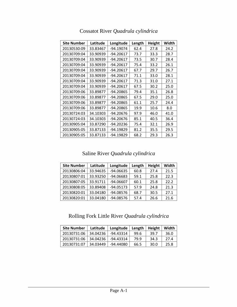
Page A-1
Cossatot River Quadrula cylindrica
Site Number Latitude Longitude Length Height Width
20130530:09 33.83467 -94.19074 62.4 27.8 24.2
20130709:04 33.90939 -94.20617 73.7 33.3 28.7
20130709:04 33.90939 -94.20617 73.5 30.7 28.4
20130709:04 33.90939 -94.20617 75.4 33.2 26.1
20130709:04 33.90939 -94.20617 67.7 29.7 26.7
20130709:04 33.90939 -94.20617 71.1 33.0 28.1
20130709:04 33.90939 -94.20617 71.3 31.0 27.1
20130709:04 33.90939 -94.20617 67.5 30.2 25.0
20130709:06 33.89877 -94.20865 79.4 35.1 26.8
20130709:06 33.89877 -94.20865 67.5 29.0 25.0
20130709:06 33.89877 -94.20865 61.1 25.7 24.4
20130709:06 33.89877 -94.20865 19.9 10.6 8.0
20130724:03 34.10303 -94.20676 97.9 46.0 41.0
20130724:03 34.10303 -94.20676 85.1 40.5 36.4
20130905:04 33.87290 -94.20236 75.4 32.1 26.9
20130905:05 33.87133 -94.19829 81.2 35.5 29.5
20130905:05 33.87133 -94.19829 68.2 29.3 26.3
Saline River Quadrula cylindrica
Site Number Latitude Longitude Length Height Width
20130806:04 33.94635 -94.06635 60.8 27.4 21.5
20130807:01 33.93250 -94.06683 59.1 25.8 22.3
20130807:05 33.91711 -94.06607 60.1 25.8 22.2
20130808:05 33.89408 -94.05173 57.9 24.8 21.3
20130820:01 33.04180 -94.08576 68.7 30.5 27.1
20130820:01 33.04180 -94.08576 57.4 26.6 21.6
Rolling Fork Little River Quadrula cylindrica
Site Number Latitude Longitude Length Height Width
20130731:06 34.04236 -94.43314 99.6 39.7 36.0
20130731:06 34.04236 -94.43314 79.9 34.3 27.4
20130731:07 34.03449 -94.44080 66.5 30.0 25.8