Embed Size (px)
Citation preview

The intentionof thisdocument is toreflectallrelevant topicsdiscussed,anywork issuedanddecisionsreachedduring thecourseofthemeeting.Anyquestions,commentsorconcernsregardingthecontentasdocumentedshallbesubmittedtoOCTOGIS.AllmeetingminutesareconsideredDRAFTuntilvotedandapprovedbytheGISSC.
Status of Minutes:
FINAL
Meeting Title: District of Columbia GIS Steering Committee (GISSC) Meeting Date: Sept 21, 2010 Meeting Location:
441 4th Street NW, Washington, DC 20001; Conference Room 1107
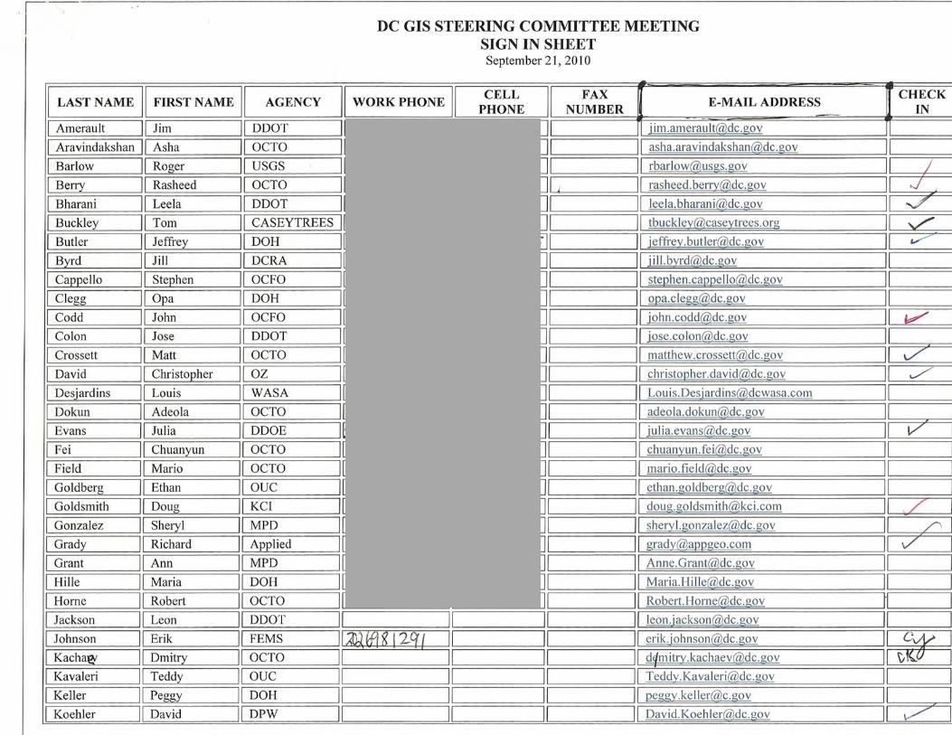
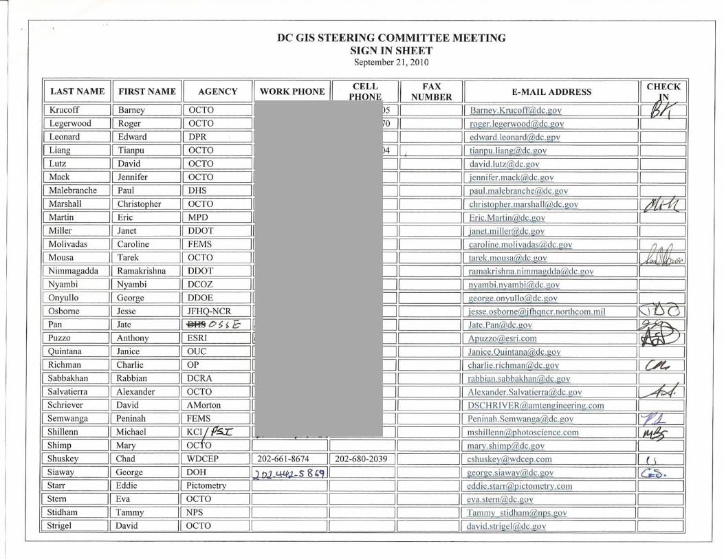
Meeting Attendees:
See Attached Sign-In Sheet
# Speaker Topic Discussed Action/Conclusion Representing Party Due Date 1 Round of Introductions 2 Barney Krucoff DC GIS News Presentation OCTO
3 2011 Budget Remarks – Success in recent procurements and doing okay in terms of funds. Operating budget is tight. Capital budget is good and can be used for capital projects.
4 DC GIS has now moved to 1100 15th Street NW, 9th Floor with other OCTO applications groups.
5 3D DC government WiFi access – a demonstration of using the Google Earth 3D browser plugin: http://3ddc.dc.gov/dcnet/wifi/
6 New Citrix Issue – the current issue is that if one user crashes, then the server is disabled making it unavailable to all users until it is restarted.
7
Residential Units in MAR – Just completed a project with USPS. We now have between 96 to 98% of residential units in the MAR to geocode against. New issue concerns the retirement of old residential units. Should we keep track of retired units?
Question/Concern
8 Charlie Richman
Yes. It is important to the Office of Planning to keep track of past units such as those in affordable housing. Will there be a service to mail all residential units?
Response OP
9 Barney Krucoff Yes we will, but that service essentially already exists with the notification tool in DC Atlas Response OCTO
10 Lindsley Williams
Could primary addresses have a count of units within it for the MAR? Question/Concern Holland
11 David Jackson Yes, we can add this to primary addresses Response OCTO
12 Barney Krucoff Notification – We’ve received positive feedback with the new notifications via the Gov Delivery system. Do people want additional notifications via

# Speaker Topic Discussed Action/Conclusion Representing Party Due Date facebook or twitter? It wouldn’t be new content, but another place to post notifications.
13 ArcGIS.com Demonstration – This will be postponed for a later time. Anthony Puzzo of ESRI has volunteered to host a separate meeting for this along with OCTO.
14 Barney Krucoff ESRI Enterprise License Agreement Presentation OCTO
15 Signed and completed by both the Offices of Contracting and Procurement and the Chief Technology Office.
16 Two year contract expiring September 2012
17 There is a lot of availability in terms of software with a few limitations. Limitations are third party software that ESRI does not own. (See presentation for details)
18 Data availability includes business analyst and also tapestry data (demographics on what persons purchase what).
19 Private ESRI technical advisor – Chris Schielein will be working with DC developers mainly in OCTO GIS
20 300 Credits for training, technical consulting, system design and more.
21 Enjoy the show now, but we need to be mindful of what we acquire. At the end of the contract we will have to pay maintenance on what we have deployed.
22 We will continue to use the large license pool that already exists.
23 We’ll focus on large scale ArcGIS Server deployments for everyone’s use.
24 Agencies that are GIS intense users will have a POC that can contact ESRI directly; however OCTO GIS will be main POC for most cases.
25 Anthony Puzzo
Remarks – There will be a change to the license model that DC now uses. Instead of standalone or concurrent licenses, they will be handled more like a check in/out process. Users can check out a license for a period of time. Additionally, mobile GIS has traditionally been on the server side, but is now included in ArcGIS desktop 10. Additional newer software includes Geoportal and Image Server extensions. Are there any questions?
Question/Concern ESRI
26 Timothy Abdella Is ESRI going to be hosting any of the DC GIS services? Or will OCTO continue to serve them? Question/Concern JMT
27 Anthony Puzzo DC central servers will continue to host DC GIS services. ESRI hosting services is not a part of the ELA. But there are other opportunities. DC GIS could chose to use the Amazon cloud for hosting services.
Response ESRI
28 Barney Krucoff District agencies that paid maintenance for this fiscal year are entitled to a credit from ESRI. Please let OCTO GIS know if you have paid for maintenance and we will coordinate with ESRI
OCTO
29 Charlie Richman
Can we install an additional software extension to track patterns of use, not just monitoring the check out of licenses? Question/Concern OP
30 Anthony Puzzo We’re looking into this option to increase this capability. We’ll follow up. Response ESRI
# Speaker Topic Discussed Action/Conclusion Representing Party Due Date
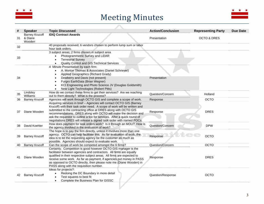
31 Barney Krucoff & Diane Wooden
IDIQ Contract Awards Presentation OCTO & DRES
32 40 proposals received; 6 vendors chosen to perform lump sum or labor hour task orders.
33
3 subject areas; 2 firms chosen in subject area Photogrammetric Survey and LiDAR Terrestrial Survey Quality Control and GIS Technical Services
34
4 Minute Presentation by each firm: A. Morton Thomas & Associates (Daniel Schriever) Applied Geographics (Richard Grady) Dewberry and Davis (not present) Furgro EarthData (Brian Wegner) KCI Engineering and Photo Science JV (Douglas Goldsmith) New Light Technologies (Robert Pitts)
Presentation
35 Lindsley Williams
How do we contact these firms to get their services? Are we reaching out to them directly? What is the process? Question/Concern Holland
36 Barney Krucoff Agencies will work through OCTO GIS and complete a scope of work. Response OCTO
37 Diane Wooden
Acquiring services in brief – Agencies will contact OCTO GIS (Barney Krucoff) with their task order need. A scope of work will be written and submitted to the contracting office at DRES along with OCTO GIS recommendations. DRES along with OCTO will make the decision and ask the requestor to outline a fee for services. After a quick round of negotiations DRES will release a signed task order with named POCs.
Response DRES
38 David Koehler How does payment for task orders work? Is it through an MOU? How is the agency involved in the evaluation of work? Question/Concern DPW
39 Barney Krucoff
The hope is to pay the firm directly, unless it involves more than one agency. OCTO can help facilitate this. As for evaluation of work, the idea is to let the requesting agency be the customer as much as possible. Agencies should expect to evaluate work.
Response OCTO
40 Barney Krucoff Can the scope of work be competed amongst the 6 firms? Question/Concern OCTO
41 Diane Wooden
Certainly. Competition is good however OCTO GIS manager is the facilitator between agencies and contractors. All firms are equally qualified in their respective subject areas. All firms are expected to receive some work. As far as payment, if agencies put money in PASS as opposed to OCTO directly, then please note me (Diane Wooden) in PASS along with the requisition number.
Response DRES
42 Barney Krucoff
Ideas for projects?: Redoing the DC Boundary in more detail Test squares to best fit Complete the Business Plan for GISSC
Question/Response OCTO
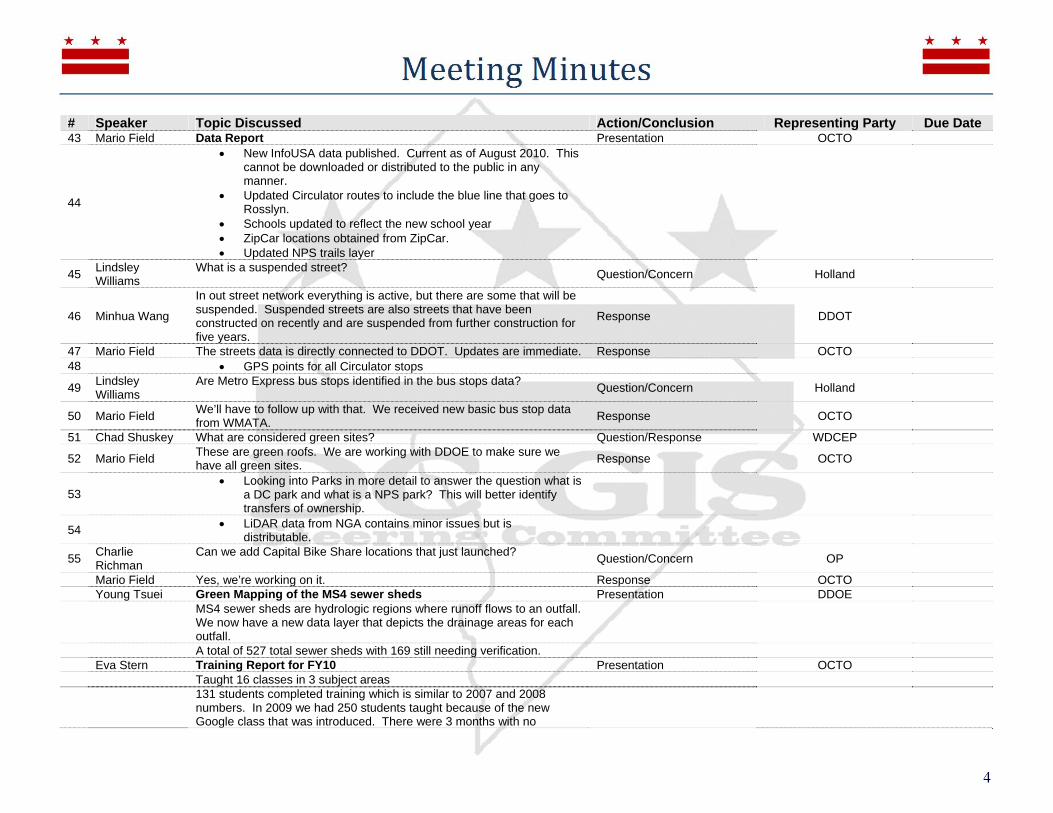
# Speaker Topic Discussed Action/Conclusion Representing Party Due Date 43 Mario Field Data Report Presentation OCTO
44
New InfoUSA data published. Current as of August 2010. This cannot be downloaded or distributed to the public in any manner.
Updated Circulator routes to include the blue line that goes to Rosslyn.
Schools updated to reflect the new school year ZipCar locations obtained from ZipCar. Updated NPS trails layer
45 Lindsley Williams
What is a suspended street? Question/Concern Holland
46 Minhua Wang
In out street network everything is active, but there are some that will be suspended. Suspended streets are also streets that have been constructed on recently and are suspended from further construction for five years.
Response DDOT
47 Mario Field The streets data is directly connected to DDOT. Updates are immediate. Response OCTO 48 GPS points for all Circulator stops
49 Lindsley Williams
Are Metro Express bus stops identified in the bus stops data? Question/Concern Holland
50 Mario Field We’ll have to follow up with that. We received new basic bus stop data from WMATA. Response OCTO
51 Chad Shuskey What are considered green sites? Question/Response WDCEP
52 Mario Field These are green roofs. We are working with DDOE to make sure we have all green sites. Response OCTO
53 Looking into Parks in more detail to answer the question what is
a DC park and what is a NPS park? This will better identify transfers of ownership.
54 LiDAR data from NGA contains minor issues but is distributable.
55 Charlie Richman
Can we add Capital Bike Share locations that just launched? Question/Concern OP
Mario Field Yes, we’re working on it. Response OCTO Young Tsuei Green Mapping of the MS4 sewer sheds Presentation DDOE
MS4 sewer sheds are hydrologic regions where runoff flows to an outfall. We now have a new data layer that depicts the drainage areas for each outfall.
A total of 527 total sewer sheds with 169 still needing verification. Eva Stern Training Report for FY10 Presentation OCTO Taught 16 classes in 3 subject areas
131 students completed training which is similar to 2007 and 2008 numbers. In 2009 we had 250 students taught because of the new Google class that was introduced. There were 3 months with no

# Speaker Topic Discussed Action/Conclusion Representing Party Due Date attendance. See presentation for additional details.
Dmitry Kachaev Open 311 API Presentation OCTO
A new API plugin that allows the public to build applications that directly enter service requests into the District’s 311 call center. This structures information that is entered into 311 and allows for information to reach 311 more quickly.
Timothy Abdella What about security concerns with entering service requests directly into 311 from the public? Question/Concern JMT
Dmitry Kachaev We have license keys that are distributed. It is free and available to anyone, but it provides a way for us to track and ensure appropriate use. Response OCTO
Minhua Wang What about concerns of integrating with existing systems that take service requests such as the CRS system? Question/Concern DDOT
Dmitry Kachaev Essentially the API provides the same capabilities within the service request center. It’s the same data in the database and same procedure. Response OCTO
Jim Amerault
How are you managing expectations of customers? For example a user that submits a tree that needs to be removed. But the arborist that inspects the tree confirms that the tree is fine and doesn’t need to be removed.
Question/Concern DDOT
Dmitry Kachaev There are specific types of service requests that customers can choose from. There are business processes that exist for each type of service request.
Response OCTO
Barney Krucoff Unfortunately Open 311 doesn’t resolve current issues with the 311 system such as unreasonable requests. This only provided another tool Response OCTO
Continued discussion on business processes of the 311 system Barney Krucoff Call to vote on the May 14th meeting minutes Approved Barney Krucoff Redistricting Presentation OCTO
DC government will be redistricting the administrative boundaries in DC such as Wards and ANCs
DC Council has the final approval over redistricting
We will need a process to help agencies migrate to the new boundaries since most of our tables include Wards. For example the Master Address Repository.
There will be new TIGERline shapefiles coming from US Census. Deliveries begin in mid February of 2011 and finished by March 2011
Gottlieb Simon
This time next year we will know what the new Wards are. We have 8 Wards that have to be equal size in population. We can make a reasonable projection that Ward 1will be smaller in terms of land mass. Wards will be decided in a 90 day session starting March 2011. ANCs will follow.
ANC
Barney Krucoff Called for a subcommittee to carefully track redistricting and report to the GISSC. Members thus far include: Charlie Richman, David Jackson, Timothy Abdella, Mario Field and Lindsley Williams. Final subcommittee
OCTO

# Speaker Topic Discussed Action/Conclusion Representing Party Due Date members are to be determined.
Douglas Goldsmith
Planimetric Project Update Presentation KCI
DC has received ortho areas 1 and 2 and currently reviewing. KCI has area 3 and undergoing QC.
Lessons learned from 2008 and applied to 2010 update: Include east/west flight lines to reduce building lean All flights occurred within 24 hours of each other on April 2nd
and 3rd of 2010. All flights were below 5,000 feet Predominantly leaf off photography Correction of a 3 meter planimetric shift in the downtown area
from 1999 planimetric update. Resolved geometry issues from legacy data. Additional planimetric features:
o Recreation courts broken down into tennis, basketball and other. This was done for impervious surface purposes
o Wheelchair ramp points 117 additional control points
Charlie Richman
Will we be able to identify changes from the old 1999 planimetrics with the 3 meter shift and the new 2010 planimetrics? Question/Concern OP
Douglas Goldsmith
The changes will not be visible since it is relatively small area. But yes, we can show and help you identify the changes. Response KCI
Roger Barlow It looks like the Virginia shoreline along area 2 of the Potomac is missing. It would be good to have at least the shoreline for other jurisdictions to match up with.
Question/Concern USGS
Douglas Goldsmith
We will look into the shoreline. The captured areas are the same as 2005 and 2008. Response KCI
Lindsley Williams
Can you identify what geometry issues from the legacy data that were resolved? Question/Concern Holland
Douglas Goldsmith
Yes, we can provide a listing of these. Response KCI
Barney Krucoff The deliverable will have data identified as deleted, added, etc. Response OCTO
Roger Barlow Can you describe the de-resolution of the imagery in protected areas such as the White House? Question/Concern USGS
Michael Shillenn
The original request by the Secret Service was to degrade the image by 3 meters. What was ultimately agreed upon was to degrade the image by 1.5 meters around protected areas. These were manually degraded by technicians in a secure location. These are the same areas as in previous orthophotos. The originals will be permanently deleted after the completion of the Planimetric project.
Response PSI
# Speaker Topic Discussed Action/Conclusion Representing Party Due Date Barney Krucoff Meeting Adjourned – The next GISSC is tentatively scheduled for
December 2010. Dismissal OCTO