Embed Size (px)
Citation preview
Disaster Mitigation of Debris Flows, Slope Failures and Landslides 815
Status of Landslide Hazard Mapping in Nepal
Vishnu DangolDepartment of Geology, Tri-Chandra Campus, Tribhuvan University, Ghantaghar, Kathmandu, Nepal([email protected])
Abstract
Landslides are one of the main natural disasters in Nepal, responsible for huge social and economiclosses for mountain populations. The annual loss of lives and property due to landslides floods is significantlyhigh in Nepal. Landslide hazard mapping is an important tool for disaster management, basic data collectionand their management. The landslide hazard maps provide required knowledge of landslide susceptibilitycondition of certain region, which is useful for the community in planning, mitigating, and avoiding the danger.On the other hand, the landslide hazard maps of a specific site are prepared for landslide monitoring as well asfor delineating areas requiring mitigation measures. Various methods of hazard assessment have been proposedand demonstrated in Nepal. With the advent of Geographic Information Systems (GIS), their use for landslidehazard assessment has been increasing constantly in recent years in Nepal. This paper describes briefly differenthazard maps carried out in Nepal and discusses the present status of hazard mapping in the country.
Keywords: landslide, hazard, hardrock, north-alpine, mountanous forest
Introduction
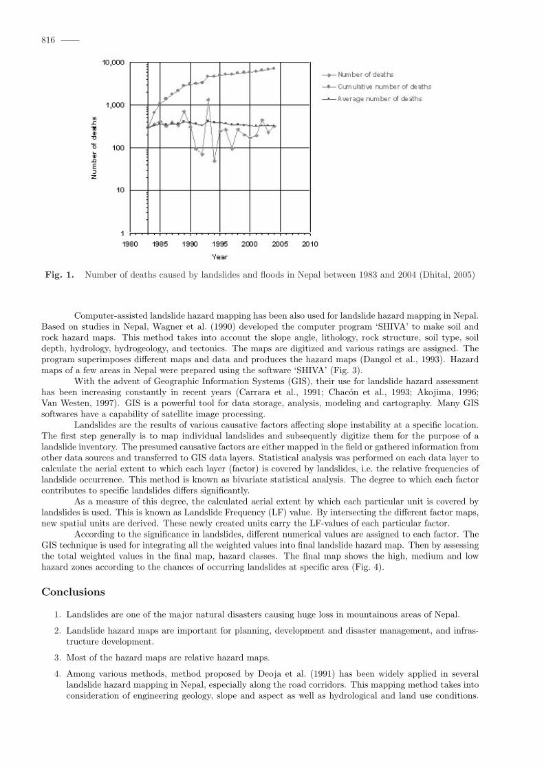
In Nepal, landslide and flood are the main natural disasters, which are responsible for huge social andeconomic losses for mountain populations. The number of deaths due to landslide and flood has remainedsignificantly high at least since the last two decades (Fig. 1). The twenty-two year average number of deathsis 329 persons, whereas the annual loss of life is as high as 1,336 persons (Dhital, 2005).
Landslide hazard mapping is an important tool for disaster management, basic data collection andlandslide management. The landslide hazard maps provide required knowledge of landslide susceptibilitycondition of certain region, which is useful for the community in planning, mitigating, and avoiding the danger.On the other hand, the landslide hazard maps of a specific site are prepared for landslide monitoring as wellas for delineating areas requiring mitigation measures.
Various methods of hazard assessment have been proposed and demonstrated in Nepal (e.g. Brundsenet al., 1975; Kojan, 1978; Wagner, 1981; Kienholz et al., 1983; Kienholz et al., 1984; Deoja et al., 1991; Dhitalet al., 1991, Dangol et al., 1993; DPTC/TU, 1994a and 1994b; DPTC, 1998; Sikrikar et al., 1998; Dangol,2000). With the advent of Geographic Information Systems (GIS), their use for landslide hazard assessmenthas been increasing constantly in recent years in Nepal. This paper describes briefly different hazard mapscarried out in Nepal and discusses the present status of hazard mapping in the country.
Landslide hazard mapping in Nepal
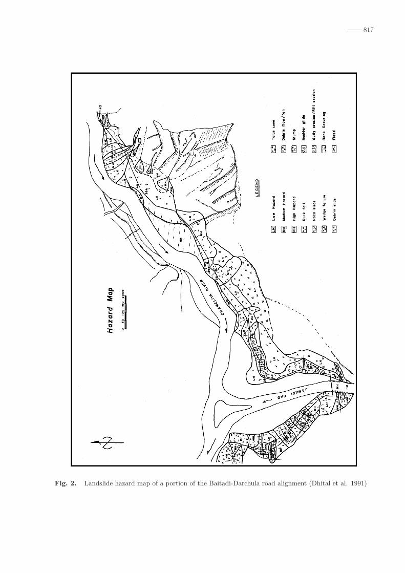
Among the several methods available for landslide hazard mapping, the method proposed by Deojaet al. (1991) has been widely applied in several landslide hazard mapping in Nepal, especially along the roadcorridors. For this mapping method requires the preparation of maps, which deal with engineering geologicalconcerns such as engineering geological, slope and aspect as well as hydrological and land use conditionsThe data for engineering geological conditions are acquired by the study of aerial photos, topographical andgeological maps, and fieldwork. The landslide hazard map is finally prepared by superimposing all of theconcerned maps and other relevant data (Fig. 2). It can show not only the hazard level, but also the main typeof failure, extent, and direction of movement in case of failure.
Broadly speaking, hazard assessment is mainly based on the study of nature (rock, soil, geomorphology,and so on), danger (old, dormant, recent landslides), and types of landslide trigger (cloudbursts, earthquakes,etc.). For the production of the final hazard map, ratings are given to the state of nature, average annualrainfall, danger and triggers, and then the values are summed up. In this method, soil slope hazard maps androck slope hazard maps are prepared separately. The hazard levels are categorized as low, medium and highdepending upon the total value of ratings.
pp. 815–819 c©2006 by Universal Academy Press, Inc. / Tokyo, Japan
816
Fig. 1. Number of deaths caused by landslides and floods in Nepal between 1983 and 2004 (Dhital, 2005)
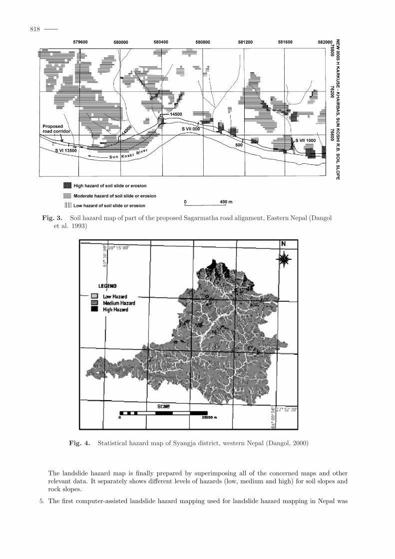
Computer-assisted landslide hazard mapping has been also used for landslide hazard mapping in Nepal.Based on studies in Nepal, Wagner et al. (1990) developed the computer program ‘SHIVA’ to make soil androck hazard maps. This method takes into account the slope angle, lithology, rock structure, soil type, soildepth, hydrology, hydrogeology, and tectonics. The maps are digitized and various ratings are assigned. Theprogram superimposes different maps and data and produces the hazard maps (Dangol et al., 1993). Hazardmaps of a few areas in Nepal were prepared using the software ‘SHIVA’ (Fig. 3).
With the advent of Geographic Information Systems (GIS), their use for landslide hazard assessmenthas been increasing constantly in recent years (Carrara et al., 1991; Chacon et al., 1993; Akojima, 1996;Van Westen, 1997). GIS is a powerful tool for data storage, analysis, modeling and cartography. Many GISsoftwares have a capability of satellite image processing.
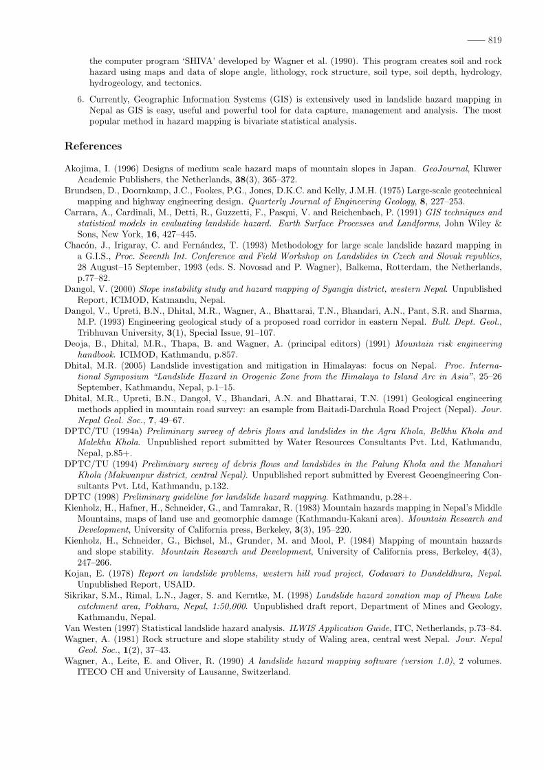
Landslides are the results of various causative factors affecting slope instability at a specific location.The first step generally is to map individual landslides and subsequently digitize them for the purpose of alandslide inventory. The presumed causative factors are either mapped in the field or gathered information fromother data sources and transferred to GIS data layers. Statistical analysis was performed on each data layer tocalculate the aerial extent to which each layer (factor) is covered by landslides, i.e. the relative frequencies oflandslide occurrence. This method is known as bivariate statistical analysis. The degree to which each factorcontributes to specific landslides differs significantly.
As a measure of this degree, the calculated aerial extent by which each particular unit is covered bylandslides is used. This is known as Landslide Frequency (LF) value. By intersecting the different factor maps,new spatial units are derived. These newly created units carry the LF-values of each particular factor.
According to the significance in landslides, different numerical values are assigned to each factor. TheGIS technique is used for integrating all the weighted values into final landslide hazard map. Then by assessingthe total weighted values in the final map, hazard classes. The final map shows the high, medium and lowhazard zones according to the chances of occurring landslides at specific area (Fig. 4).
Conclusions
1. Landslides are one of the major natural disasters causing huge loss in mountainous areas of Nepal.
2. Landslide hazard maps are important for planning, development and disaster management, and infras-tructure development.
3. Most of the hazard maps are relative hazard maps.
4. Among various methods, method proposed by Deoja et al. (1991) has been widely applied in severallandslide hazard mapping in Nepal, especially along the road corridors. This mapping method takes intoconsideration of engineering geology, slope and aspect as well as hydrological and land use conditions.
817
Fig. 2. Landslide hazard map of a portion of the Baitadi-Darchula road alignment (Dhital et al. 1991)
818
Fig. 3. Soil hazard map of part of the proposed Sagarmatha road alignment, Eastern Nepal (Dangolet al. 1993)
Fig. 4. Statistical hazard map of Syangja district, western Nepal (Dangol, 2000)
The landslide hazard map is finally prepared by superimposing all of the concerned maps and otherrelevant data. It separately shows different levels of hazards (low, medium and high) for soil slopes androck slopes.
5. The first computer-assisted landslide hazard mapping used for landslide hazard mapping in Nepal was
819
the computer program ‘SHIVA’ developed by Wagner et al. (1990). This program creates soil and rockhazard using maps and data of slope angle, lithology, rock structure, soil type, soil depth, hydrology,hydrogeology, and tectonics.
6. Currently, Geographic Information Systems (GIS) is extensively used in landslide hazard mapping inNepal as GIS is easy, useful and powerful tool for data capture, management and analysis. The mostpopular method in hazard mapping is bivariate statistical analysis.
References
Akojima, I. (1996) Designs of medium scale hazard maps of mountain slopes in Japan. GeoJournal, KluwerAcademic Publishers, the Netherlands, 38(3), 365–372.
Brundsen, D., Doornkamp, J.C., Fookes, P.G., Jones, D.K.C. and Kelly, J.M.H. (1975) Large-scale geotechnicalmapping and highway engineering design. Quarterly Journal of Engineering Geology, 8, 227–253.
Carrara, A., Cardinali, M., Detti, R., Guzzetti, F., Pasqui, V. and Reichenbach, P. (1991) GIS techniques andstatistical models in evaluating landslide hazard. Earth Surface Processes and Landforms, John Wiley &Sons, New York, 16, 427–445.
Chacon, J., Irigaray, C. and Fernandez, T. (1993) Methodology for large scale landslide hazard mapping ina G.I.S., Proc. Seventh Int. Conference and Field Workshop on Landslides in Czech and Slovak republics,28 August–15 September, 1993 (eds. S. Novosad and P. Wagner), Balkema, Rotterdam, the Netherlands,p.77–82.
Dangol, V. (2000) Slope instability study and hazard mapping of Syangja district, western Nepal. UnpublishedReport, ICIMOD, Katmandu, Nepal.
Dangol, V., Upreti, B.N., Dhital, M.R., Wagner, A., Bhattarai, T.N., Bhandari, A.N., Pant, S.R. and Sharma,M.P. (1993) Engineering geological study of a proposed road corridor in eastern Nepal. Bull. Dept. Geol.,Tribhuvan University, 3(1), Special Issue, 91–107.
Deoja, B., Dhital, M.R., Thapa, B. and Wagner, A. (principal editors) (1991) Mountain risk engineeringhandbook. ICIMOD, Kathmandu, p.857.
Dhital, M.R. (2005) Landslide investigation and mitigation in Himalayas: focus on Nepal. Proc. Interna-tional Symposium “Landslide Hazard in Orogenic Zone from the Himalaya to Island Arc in Asia”, 25–26September, Kathmandu, Nepal, p.1–15.
Dhital, M.R., Upreti, B.N., Dangol, V., Bhandari, A.N. and Bhattarai, T.N. (1991) Geological engineeringmethods applied in mountain road survey: an esample from Baitadi-Darchula Road Project (Nepal). Jour.Nepal Geol. Soc., 7, 49–67.
DPTC/TU (1994a) Preliminary survey of debris flows and landslides in the Agra Khola, Belkhu Khola andMalekhu Khola. Unpublished report submitted by Water Resources Consultants Pvt. Ltd, Kathmandu,Nepal, p.85+.
DPTC/TU (1994) Preliminary survey of debris flows and landslides in the Palung Khola and the ManahariKhola (Makwanpur district, central Nepal). Unpublished report submitted by Everest Geoengineering Con-sultants Pvt. Ltd, Kathmandu, p.132.
DPTC (1998) Preliminary guideline for landslide hazard mapping. Kathmandu, p.28+.Kienholz, H., Hafner, H., Schneider, G., and Tamrakar, R. (1983) Mountain hazards mapping in Nepal’s Middle
Mountains, maps of land use and geomorphic damage (Kathmandu-Kakani area). Mountain Research andDevelopment, University of California press, Berkeley, 3(3), 195–220.
Kienholz, H., Schneider, G., Bichsel, M., Grunder, M. and Mool, P. (1984) Mapping of mountain hazardsand slope stability. Mountain Research and Development, University of California press, Berkeley, 4(3),247–266.
Kojan, E. (1978) Report on landslide problems, western hill road project, Godavari to Dandeldhura, Nepal.Unpublished Report, USAID.
Sikrikar, S.M., Rimal, L.N., Jager, S. and Kerntke, M. (1998) Landslide hazard zonation map of Phewa Lakecatchment area, Pokhara, Nepal, 1:50,000. Unpublished draft report, Department of Mines and Geology,Kathmandu, Nepal.
Van Westen (1997) Statistical landslide hazard analysis. ILWIS Application Guide, ITC, Netherlands, p.73–84.Wagner, A. (1981) Rock structure and slope stability study of Waling area, central west Nepal. Jour. Nepal
Geol. Soc., 1(2), 37–43.Wagner, A., Leite, E. and Oliver, R. (1990) A landslide hazard mapping software (version 1.0), 2 volumes.
ITECO CH and University of Lausanne, Switzerland.


![A Combined Model for Landslide Susceptibility, Hazard and ... · 18]. However, landslide hazard and risk evaluation are not a frequent topic in recent landslide literature [19, 20]](https://img.pdfslide.us/doc/110x75/5e744b3821bc3621652d4065/a-combined-model-for-landslide-susceptibility-hazard-and-18-however-landslide.jpg)