Embed Size (px)
Citation preview
CONSERVATIONCONSERVATION
REPORT REPORT
SERIESSERIES
Status and Distribution of ArcticGrayling (Thymallus arcticus) in the Pembina River, Alberta

CONSERVATIONCONSERVATION
REPORT REPORT
SERIESSERIES 25% Post Consumer Fibre
When separated, both the binding and paper in this document are recyclable
The Alberta Conservation Association is a Delegated Administrative Organization under Alberta’s Wildlife Act.
Status and Distribution of Arctic grayling (Thymallus arcticus) in the Pembina River, Alberta
Mike Blackburn and Craig F. Johnson
Alberta Conservation Association, #203, Provincial Building, 111 – 54 Street,
Edson, Alberta, Canada, T7E 1T2

Report Series Editor PETER AKU P.O. Box 40027 Baker Centre Postal Outlet Edmonton, AB, T5J 4M9 Conservation Report Series Type Data, Technical ISBN printed: 978‐0‐7785‐5407‐3 ISBN online: 978‐0‐7785‐5408‐0 Publication Number: T/122 Disclaimer: This document is an independent report prepared by the Alberta Conservation Association. The authors are solely responsible for the interpretations of data and statements made within this report. Reproduction and Availability: This report and its contents may be reproduced in whole, or in part, provided that this title page is included with such reproduction and/or appropriate acknowledgements are provided to the authors and sponsors of this project. Suggested citation: Blackburn, M., and C.F. Johnson. 2004. Status and distribution of Arctic grayling
(Thymallus arcticus) in the Pembina River, Alberta. Technical Report, T‐2004‐003, produced by Alberta Conservation Association, Edson, Alberta, Canada. 25 pp +App.
Digital copies of this and other conservation reports can be obtained from: Alberta Conservation Association P.O. Box 40027, Baker Centre Postal Outlet Edmonton, AB, T5J 4M9 Toll Free: 1‐877‐969‐9091 Tel: (780) 427‐5192 Fax: (780) 422‐6441 Email: info@ab‐conservation.com Website: www.ab‐conservation.com
i
ii
EXECUTIVE SUMMARY
The Pembina River sub‐basin, found in the Athabasca River Drainage, supports the
most southern, naturally occurring population of Arctic grayling in Alberta. Prior to
the 1970’s, Arctic grayling were considered common throughout the mid to upper
reaches of the Pembina River mainstem. However, since that time, surveys on the
Pembina River mainstem suggest low numbers of this species. Consequently, the
Alberta Conservation Association, in collaboration with the Alberta Sustainable
Resource Development, conducted a study during the open water seasons of 2002 and
2003 to assess the present status and distribution of Arctic grayling in the Pembina
River.
The proposed study area included the Pembina River mainstem from the Lovett River
confluence downstream to the Paddle River. After preliminary sampling in 2002, the
study area was redefined in 2003 to include the Pembina River mainstem from the
mouth of the Lovett River downstream to the Highway 16 river crossing at Evansburg.
Species distribution, relative abundance, and population structure data were collected
using float electrofishing, angling, and snorkelling. Quantitative habitat data were also
collected including: wetted river widths, rooted river widths, and water temperature
data collected continuously through time from several locations in the study area. All
fish and habitat data were entered into Alberta Sustainable Resource Development’s
provincial fisheries database: the Fisheries Management Information System.
Over the two years, a total (combined float electrofishing, angling, and snorkelling) of
2817 fish were captured or observed in the Pembina River. Arctic grayling were rare,
accounting for less than 2.5% of the recorded total. Forty‐six Arctic grayling were
captured in 52.8 km and 591.7 minutes of electrofishing and 22.7 km and 56.5 hours of
angling. An additional 22 Arctic grayling were observed during four snorkelling
events for a total of 68 grayling. Arctic grayling float electrofishing and angling catch
rates from the Pembina River were considerably lower than reported for other Alberta
rivers. Angling accounted for 42 of the 46 Arctic grayling which were caught near a
road access; 33 of the 42 angling captures were from one pool immediately downstream
of a bridge crossing.
The mean fork length of Arctic grayling captured was 213 mm (range = 115 ‐ 339 mm).
Ninety‐five percent of the captured Arctic grayling were juveniles of either 1 or 2 years
of age.
Sampling was initiated during the spring and summer of 2002. Extremely low water
conditions during both 2002 and 2003 prevented spring, summer, and fall re‐sampling
of the float electrofishing sites. Although grayling were captured upstream from the
confluence with Paddy Creek only, we were unable to describe Arctic grayling seasonal
distribution.
Low numbers of Arctic grayling captured or observed in two years of sampling, low
electrofishing and angling catch rates, and a limited river distribution, suggests that
Arctic grayling stocks in the Pembina River are probably collapsed.
Key words: Alberta, Pembina River, Arctic grayling, distribution, abundance, size composition, float electrofishing, angling, snorkelling, age, size‐at‐age, catch rate.
iii

iv
ACKNOWLEDGEMENTS
This work was funded by the Alberta Conservation Association (ACA). In addition, the
ACA received in‐kind support from Alberta Sustainable Resource Development,
Fisheries Management Division in Edson, Hinton, and Stony Plain.
Stephen Spencer, Area Fisheries Biologist, Fisheries Management Division in Stony
Plain, and George Sterling, Area Fisheries Biologist, Fisheries Management Division in
Edson provided critical review of the project design and of this report, and contributed
to field data collection.
Special thanks to Calvin McLeod, East Slopes Business Unit Leader, ACA; and Kevin
Fitzsimmons, Fisheries Biologist, ACA, for critical review of this report.
Christian Weik, Geographic Information System Analyst, Foothills Model Forest
(Hinton, AB), provided assistance with generating the Pembina River profile data.
Thanks to Rudy Hawryluk, Don Hildebrandt, Julie Hebert, Corey Rasmussen, James
Milner, Norm Rodseth and Susan Parsons for their contributions to field data
collection.


v
TABLE OF CONTENTS
EXECUTIVE SUMMARY.............................................................................................. ii
ACKNOWLEDGEMENTS........................................................................................... iv
TABLE OF CONTENTS ................................................................................................ v
LIST OF FIGURES ......................................................................................................... vi
LIST OF TABLES .......................................................................................................... vii
LIST OF APPENDICES ..............................................................................................viii
1.0 INTRODUCTION.................................................................................................1
1.1 General introduction ............................................................................................1 1.2 Study rationale ......................................................................................................2 1.3 Study objectives ....................................................................................................2
2.0 STUDY AREA .......................................................................................................3
3.0 MATERIALS AND METHODS..........................................................................5
3.1 Site selection ..........................................................................................................5 3.2 Site length ..............................................................................................................6 3.3 Fish capture and data collection.........................................................................6 3.4 Habitat data ...........................................................................................................7 3.5 Data management and analysis..........................................................................8
4.0 RESULTS................................................................................................................9
4.1 Electrofishing.......................................................................................................10 4.2 Angling.................................................................................................................12 4.3 Snorkelling...........................................................................................................13 4.4. Size distribution of Arctic grayling..................................................................14 4.5 Age composition of Arctic grayling.................................................................15 4.6 Distribution of Arctic grayling .........................................................................16 4.7 Water temperature data.....................................................................................17
5.0 DISCUSSION.......................................................................................................18
6.0 REFERENCES......................................................................................................21
7.0 APPENDIX ..........................................................................................................26
vi
LIST OF FIGURES
Figure 1. Location of the 2002‐2003 Arctic grayling study sites on the Pembina River, Alberta. ...................................................................................................4
Figure 2. Sites sampled using float electrofishing on the Pembina River, Alberta from May to October 2002 and 2003. ............................................................11
Figure 3. Sites angled as part of the Arctic grayling population assessment conducted on the Pembina River, Alberta in June to October 2002 and 2003....................................................................................................................12
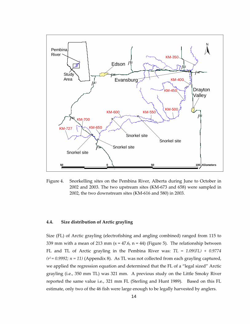
Figure 4. Snorkelling sites on the Pembina River, Alberta during June to October in 2002 and 2003...............................................................................................14
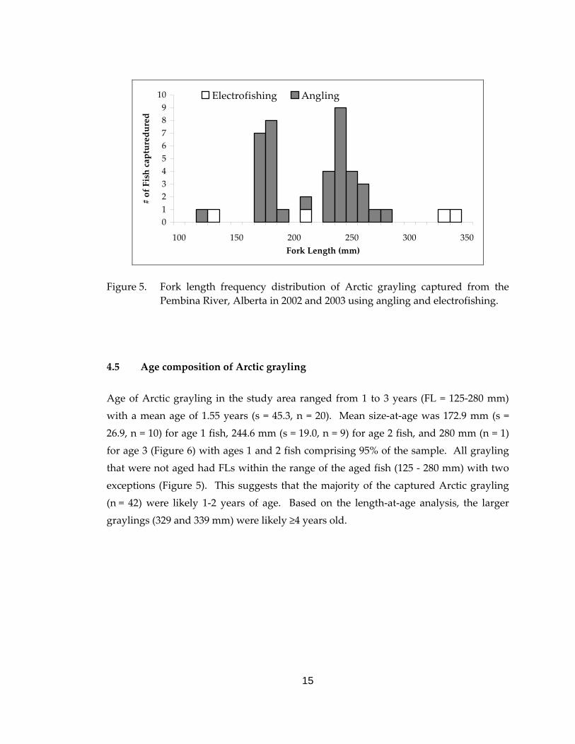
Figure 5. Fork length frequency distribution of Arctic grayling captured from the Pembina River, Alberta in 2002 and 2003 using angling and electrofishing....................................................................................................15
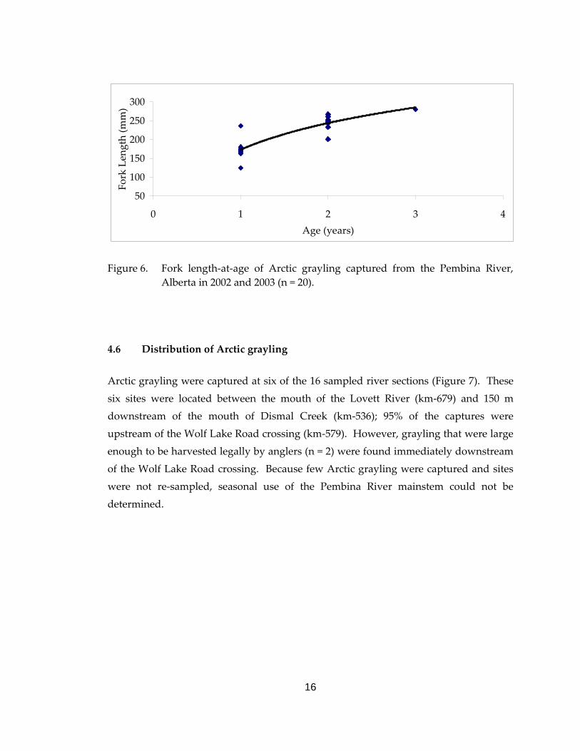
Figure 6. Fork length‐at‐age of Arctic grayling captured from the Pembina River, Alberta in 2002 and 2003. ...............................................................................16
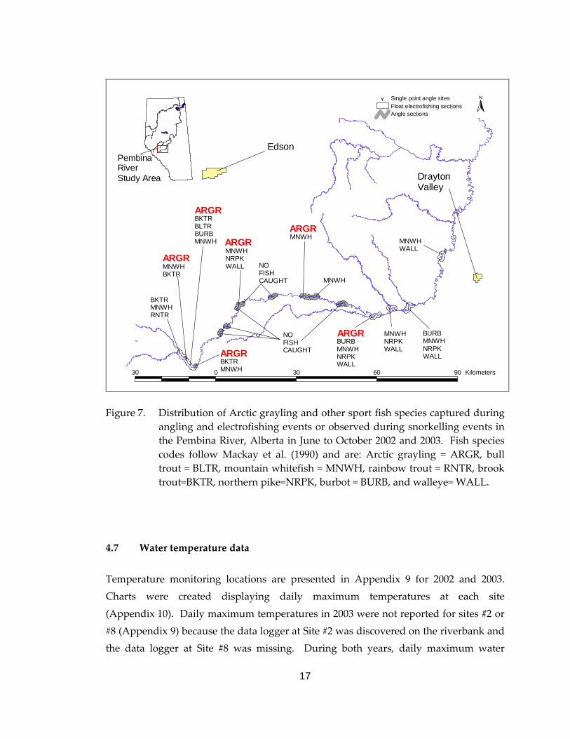
Figure 7. Distribution of Arctic grayling and other sport species captured during angling and electrofishing events or observed during snorkelling events in the Pembina River, Alberta in June to October 2002 and 2003. ..........17
Figure 8. Number of days the maximum water temperatures surpassed 25oC in the Pembina River in 2002 and 2003....................................................................18

vii
LIST OF TABLES
Table 1. Fish species composition encountered during the Pembina River study in 2002 and 2003; n = 2817. Species codes after Mackay et. al. (1990). .........10
viii
LIST OF APPENDICES
Appendix 1. Gradient or slope profile (meters above sea level) of the 2002‐2003 study sites on the Pembina River, Alberta..............................................................26
Appendix 2. Pembina River fish capture record form......................................................27
Appendix 3. Pembina River float‐electrofishing data form.. ...........................................28
Appendix 4. Pembina River flow data recorded by Alberta Environment near the Town of Entwistle Alberta in 2002 and 2003 . ............................................29
Appendix 5. Individual records of each fish captured during the summers of 2002 and 2003 as part of the Arctic grayling population assessment on the Pembina River, Alberta. ..................................................................................................31
Appendix 6. Summaries of fish captured at each electrofishing site during the 2002‐ 2003 survey on the Pembina River, Alberta. ...............................................75
Appendix 7. Summary of fish captured by angling on the Pembina River mainstem on July 4 to September 20, 2002 and August 7 to October 21, 2003. ..............81
Appendix 8. A regression model describing the relationship between fork length and total length for 11 Arctic grayling captured in the Pembina River during the summers of 2002 and 2003.......................................................................82
Appendix 9. The locations of water temperature data loggers deployed in the Pembina River mainstem, during the summers of 2002 and 2003. ..........83
Appendix 10. Summaries of daily maximum water temperatures collected by data loggers deployed throughout the Pembina River mainstem during the summers of 2002 and 2003. ............................................................................84
1
1.0 INTRODUCTION 1.1 General introduction Arctic grayling (Thymallus arcticus) have a Holarctic distribution, typically occurring in
northern freshwater drainages of Canada, Alaska, and Eurasia (Scott and Crossman
1973). Disjunct populations of grayling also occur in Montana, U.S.A., and are thought
to have been maintained by introductions through stocking from sources in Canada
(Scott and Crossman 1973). In Alberta, Arctic grayling are native to the Athabasca,
Peace, and Hay River drainages (Nelson and Paetz 1992), all of which flow into the
Arctic Ocean via the Mackenzie River. Although the Pembina River sub‐basin
(Athabasca River drainage) defines the southern fringe of indigenous populations of
Arctic grayling in Alberta, they have been captured on rare occasions from the Belly
River (South Saskatchewan River drainage) in southern Alberta (Nelson and Paetz
1992), likely as the result of dispersal from Montana (Scott and Crossman 1973).
Requiring cold, clear, clean water Arctic grayling are a species considered vulnerable to
habitat alterations and over‐exploitation because of their ease of capture, late maturity,
and slow growth (Scott and Crossman 1973). In the last 40 years, increased human land
use and improved access have contributed to habitat alteration and overexploitation
and the resulting decline of Alberta’s Arctic grayling stocks (Berry 1998). In 1998,
Arctic grayling was classified as a species of special concern, and provincially
designated with a “vulnerable” status in Alberta. Subsequently an Arctic grayling
management and recovery plan was developed in an effort to protect these decreasing
fish stocks (Berry 1998). In 1998 the Alberta government implemented more restrictive
regulations where winter and spring sport fishing seasons for Arctic grayling were
closed and anglers could catch and keep grayling during the summer period only
followed by a catch‐and‐release season during the fall (Berry 1998; Alberta Government
1998). This was done presumably to protect grayling when they were most
concentrated. Also, the allowable daily harvest was reduced from five to two fish with
an increase in the minimum‐size limit from 330 mm total length (TL) to 350 mm (Berry
1998; Alberta Government 1998). Catch‐and‐release fisheries (zero harvest) were also
established at certain streams (Berry 1998; Alberta Government 1998).
2
1.2 Study rationale
The Pembina River watershed supports the most southern, naturally occurring
population of Arctic grayling in Alberta (Nelson and Paetz 1992). Prior to the 1970’s,
Arctic grayling were considered common throughout the mid to upper reaches of the
Pembina River mainstem with reported angler catch rates of Arctic grayling that
ranged from 1.0 to 3.0 grayling/hour and electrofishing catch rates of 0.5 to 1.0
grayling/minute (Bryski 1999). Since that time, the limited surveys conducted on the
Pembina River mainstem (Renewable Resources Consulting Services 1971; Antoniuk
and Carey 1979; Dickson and McCart 1980; Foothills Model Forest 1998) have reported
low occurrences of Arctic grayling. Current catch‐and‐release angling regulations
protect Arctic grayling stocks from harvest within the tributaries of the Pembina River;
however legal harvest is allowed (2 grayling over 35 cm) on the river’s mainstem
(Alberta Government 2003). It is unknown if the current regulations are effective for the
protection and sustainability of the native grayling population. To forestall a collapse
of the fishery, the Alberta Sustainable Resource Development (ASRD) identified the
management of the Pembina River Arctic grayling population as a priority and
developed a joint assessment project with the Alberta Conservation Association (ACA)
to collect data to support or adjust the current Pembina River Arctic grayling
management plan.
1.3 Study objectives
The objective of this study was to describe the status of Arctic grayling stocks within
the Pembina River mainstem. These data would be provided to ASRD fisheries
managers to assist in the development of a comprehensive fisheries management plan
for the Pembina River Watershed. The specific objectives of this study were:
1. To determine the distribution and abundance of Arctic grayling and
related habitat descriptors in the mainstem of the Pembina River
between the confluence with Lovett Creek (Highway 40 road crossing)
and the Highway 16 road crossing. These data can assist ASRD to
develop an Arctic grayling management plan for the Pembina River
mainstem, and possibly the entire watershed.

3
2. To determine seasonal use of the Pembina River mainstem by Arctic
grayling.
3. To collect non‐lethal biological data from Arctic grayling captured
during the survey including fork length, weight, scales for ageing, and
sex and state of maturity if available. In addition, collect these data for
all fish species and provide to ASRD as a condition of the fish research
license.
2.0 STUDY AREA
Originating in the Rocky Mountains, the Pembina River mainstem flows east by
northeast for approximately 727 km until its confluence with the Athabasca River,
northeast of Fort Assiniboine, Alberta. Major tributaries to the Pembina River, from the
headwaters to the mouth, include the Lovett River, Dismal, Rat, and Paddy creeks;
along with the Bigoray, Lobstick and Paddle rivers. The Pembina River and its
tributaries occur in the subalpine, upper boreal, lower boreal mixedwoods, and lower
boreal ecoregions (Strong and Leggat 1992) and consequently, contain a variety of fish
habitats, ranging from swift, clear, cold water, with gravel‐boulder substrates in the
upper reaches to slow, turbid, warm water, with silty substrates in the lower reaches
(Wallace and McCart 1984).
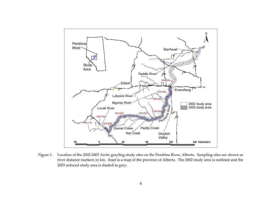
The study area initially included the Pembina River mainstem from the confluence with
the Lovett River downstream to the confluence with the Paddle River near the town of
Barrhead, Alberta. After a preliminary sampling in 2002, the study area was reduced in
2003 to include the Pembina River mainstem from the mouth of the Lovett River (River
distance: km‐679) downstream to the bridge crossing on Highway 16 (km‐366) at
Evansburg, Alberta (Figure 1). This allowed for a more efficient use of resources in
2003.
4
#
KM-727
#
KM-700
#
KM-650
#
KM-600#
KM-550#
KM-500
#
KM-450
#
KM-400
#
KM-350
#
DraytonValley
#
#
Edson#
Evansburg
#Barrhead
(/47
(/22
(/22 (/43(/32
(/18
(/33
(/16
(/40
(/734
#
Lovett River
#
Dismal Creek
#
Rat Creek
#
Paddy Creek
#
Bigoray River
#
Lobstick River
#
Paddle River
Pe mbina
Riv
e r
(/16
40 0 40 80 120 160 Kilometers
N
#
PembinaRiver
StudyArea
2003 study area2002 study area
Figure 1. Location of the 2002‐2003 Arctic grayling study sites on the Pembina River, Alberta. Sampling sites are shown as river distance markers in km. Inset is a map of the province of Alberta. The 2002 study area is outlined and the 2003 reduced study area is shaded in grey.
5
3.0 MATERIALS AND METHODS
3.1 Site selection
Adult Arctic grayling generally migrate from larger rivers to smaller tributaries for
spring spawning and return to the larger rivers during the summer (Scott and
Crossman 1973, Stanislawski and Brown 1997). A recent study has also shown that
habitat diversity, in the form of size and depth of pools, channel complexity, and
substrate composition, are higher where tributary streams enter mainstem rivers (Rice
et al. 2001). Thus we believe that Arctic grayling will likely be located at or near
tributary junctions throughout this study, therefore sample sites were primarily aligned
with the mouths of major tributaries to the Pembina River in attempts to capture Arctic
grayling throughout the open water season. We also chose sample sites that had been
sampled previously (e.g., Renewable Resources Consulting Services 1971). Repeated
sampling of historical sites with those sampled in 2002 and 2003 provided us with the
opportunity to quantify spatial and temporal changes in the occurrence and abundance
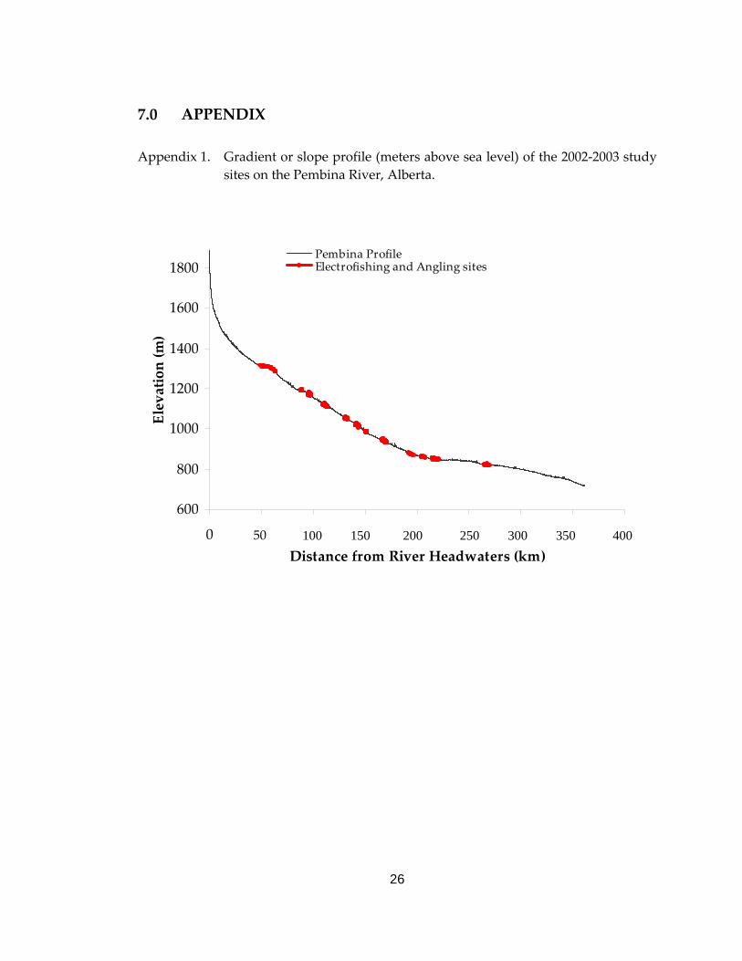
of Arctic grayling. To ensure that habitats of differing gradients were sampled, survey
sites were plotted on a gradient profile for the Pembina River (Appendix 1). New sites
were identified based on the gradient profile where reaches appeared to exist. The final
choice of sites was based on site accessibility by all‐terrain‐vehicle (ATV) or truck.
A helicopter was used to survey the river for obstructions (logjams, shallow water,
waterfalls, etc.) and potential access points which were then marked on maps using a
handheld Global Positioning System (GPS) unit. We then used ArcView 3.0,
Geographic Information System (GIS) data (i.e. base layers on: roads, seismic lines,
pipelines, power lines) and 5‐m Indian Remote Sensing satellite imagery to identify any
potential access routes that were undetected during the helicopter flight. Access points
and routes that required ground‐truthing for accessibility and boat‐launching
capabilities were investigated using 4x4 trucks and all terrain vehicles (ATV). Some of
the sample sections were also canoed to assess what type of boat to use, as well as to
determine river conditions (e.g., water depth and wetted width) and navigational
hazards (e.g., sweepers, ledges, or logjams) that were difficult to evaluate from the
survey flight.
6
3.2 Site length
Length of study reaches (i.e., river site length) was chosen according to Hughes et. al.
(2002). In order to sample representative fish assemblages for rivers ranging in width
from 10‐150 m and sampled using a raft‐mounted electrofisher, a minimum sampling
distance equal to 85 times the mean wetted channel width is required. Estimates of site
length recorded within ±100 m in the field using a hand‐held GPS unit were later
refined in the lab to within ±10 m using ArcView 3.1a. Waypoints were used to
calculate the total river length sampled and were marked at 500‐m intervals. The 500‐m
intervals were also used as reference points to release captured fish.
3.3 Fish capture and data collection
Fish were captured primarily by a three‐person team using float electrofishing from
July 4 to September 20, 2002 and June 27 to October 21, 2003. A 14‐foot Avon
Adventurer raft, equipped with a generator‐powered Smith Root 5.0 G.P.P.
electrofisher, was navigated by one crewmember while a second crewmember
controlled the anode and the third dip‐netted fish. Attempts were made to capture all
fish, but field crews selected for Arctic grayling when they were present. Species
composition and electrofishing effort (seconds) and settings (amperage, range, and
percent power) were recorded for each survey. Captured fish were kept in an onboard
live well until they were measured and released at each 500‐m transect. Very few
fish (<1%) demonstrated injuries or immediate mortality from electrofishing. It is
unknown what the post‐release delayed mortality rate was. In addition, fish were
captured using fly‐fishing gear in sections that were not suitable for rafting (e.g. low
water conditions or log jams). Both wet and dry flies were used in combination with a
5‐ or 6‐weight fly rod equipped with a floating line. Anglers recorded fish captured,
number of hours angled (±0.25 hours), and the distance angled. Although no immediate mortalities occurred from angling, it is unknown what the post‐release
delayed mortality rate was.
When water conditions were extremely low making the river impassable with the raft,
snorkelling was used to identify and describe the distribution and number of fish
7
species (Thurow 1994). The river was divided into two units, river left and river right,
and two snorkellers drifted downstream side‐by‐side and counted fish in their half of
the river. When fish were encountered at a high rate (i.e., pools), the area would be
surveyed three times and each drift count was then used to determine a single mean
estimate.
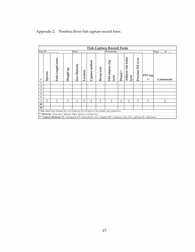
Data were recorded on a “Fish Capture Record Form” (Appendix 2) at each 500‐m
transect. Fish were identified to species using Scott and Crossman (1973) and Nelson
and Paetz (1992) and species codes were assigned using Mackay et. al. (1990). Data
collection included: fork length (FL) and total length (TL) (±1.0 mm), sex and state of
maturity (when discernable), location (i.e. transect number), and any relevant
comments (i.e., any abnormalities present on the fish, clipped fins, or if the fish was a
mortality). In addition a stratified sample (2 fish/5 mm FL class) was collected for
mountain whitefish and Arctic grayling. Additional data collected from these fish
included: total weight (±1.0 gm), and scale samples (after Mackay et al. 1990). To avoid
mortality, scales rather than otoliths were used for aging Arctic grayling.
3.4 Habitat data
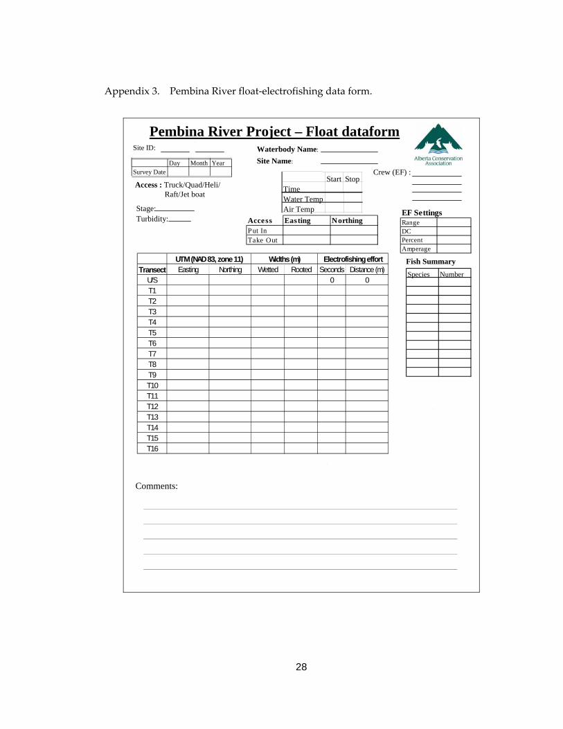
Quantitative habitat attributes were recorded on the “Pembina River Project‐ Float Data
Form” (Appendix 3). Rooted and wetted widths were measured at the beginning and
end of each 500‐m. Rooted and wetted channel widths were measured at a right angle
to the direction of the flow using a BushnellTM Yardage Pro 800 laser rangefinder (±1 m).
Arctic grayling demonstrate a maximum temperature preference of approximately 25oC
(Lohr et. al. 1996). As the study area is the southern limit of grayling distribution in
Alberta, we felt that daily maximum temperatures may help define summer
distributions. Continuous (2‐hour interval) water temperature data were collected
along the length of the Pembina River study area using Onset Computer Corporation
HOBOTM Temp data loggers. Data logger locations were determined by truck access
(i.e., road crossings or roads paralleling river) and loggers were deployed from July 7 to
October 14 in 2002 and from June 6 to September 28 in 2003. Data loggers were housed
in a watertight plastic container, secured with a 3.2‐mm steel cable to an anchor (e.g.,
8
tree, large boulder, or bridge pillar) and weighted down with a 1.0‐kg lead weight.
This prevented the data logger from being swept downstream or out of the water
column during high flows. At the end of the study period, all the data loggers were
retrieved except for two (one in 2002 and one in 2003), which may have been swept
away by the river or stolen.
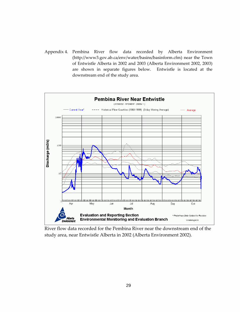
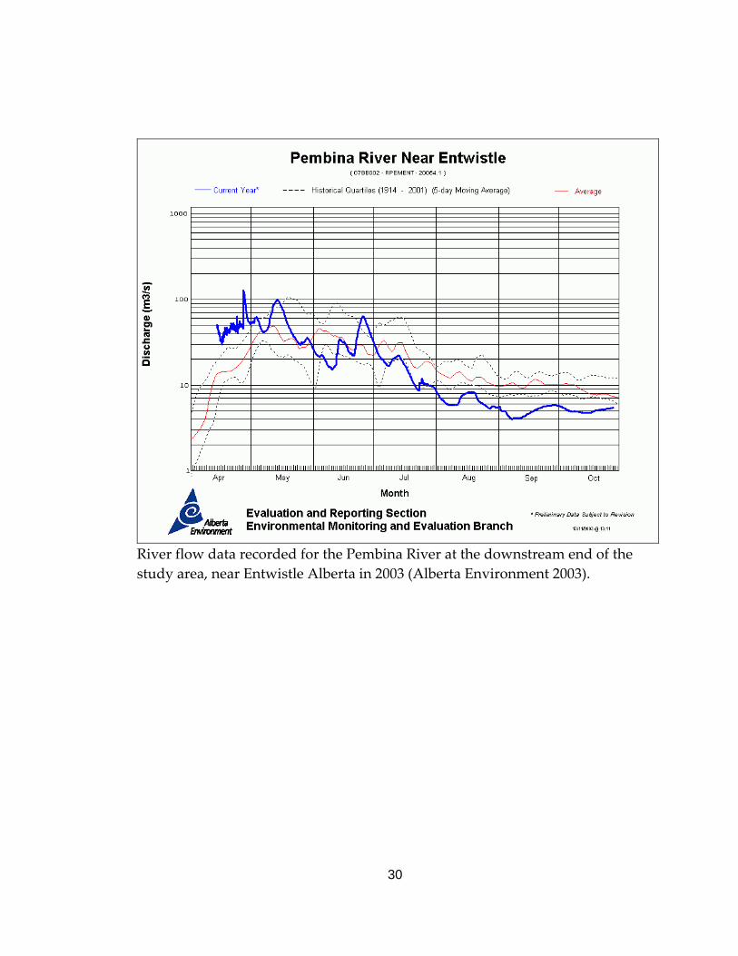
Flow data for the Pembina River in 2002 and 2003 (Appendix 4) were obtained from the
Alberta Environment River Basins web site (Alberta Environment 2002, Alberta
Environment 2003). These data were used primarily to assess river conditions and
assist with determination of which sampling technique should be used, i.e., boat or
float electrofishing, angling, or snorkelling.
3.5 Data management and analysis
Data were entered into Microsoft Access for analyses and reporting. To comply with
the conditions of the ASRD Fisheries Research License (FRL # 02‐2008 and 03‐2002),
data were entered into Fisheries Management Information System (FMIS) load forms
(Ledig et. al. 1998). These load forms were subsequently provided to ASRD for loading
into the provincial database (FMIS).
Data were analyzed using a variety of techniques. Calculating the frequency
distributions of FL resulted in histograms of these data. Although FL is the preferred
field measurement of length, TL is the measure used for management. To convert FL to
TL we compared TL against FL using least‐squares linear regression (JMP 5.1). The
resulting formula allows for predictions, within the range of data used in the
calculations, of TL from FL.
Float electrofishing catch rates were calculated as the number of fish captured per
wetted section area. Section area was calculated using section length times mean
wetted width. Fish catch rates were then converted to number of fish/1000 m2 to allow
for comparisons of catch in sections of differing river widths. Although a catch rate
that incorporates depth and subsequently volume may improve the ability to compare
between sites, this was not done to allow for increased efficiency in the field. We felt
9
that the improvements to the final answer did not justify the cost of collecting these
data.
Temperature data were downloaded from the data loggers and saved as a Microsoft
Excel file. Microsoft Access was used to report the daily maximum temperatures.
Each survey site was geo‐referenced in the field using a handheld GarminTM 12 XL GPS
unit. Co‐ordinate data (waypoints and tracks) were collected as Universal Transverse
Mercator numbers (UTMs), Zone 11, North American Datum 1983 (NAD 83).
Waypoints and tracks were downloaded and saved as an ArcView shapefile using the
Department of Natural Resources Garmin (DNR Garmin) extension (Minnesota
Department of Natural Resources 2003).
4.0 RESULTS
A total of 10 float electrofishing, 11 angling, and 4 snorkelling events were conducted in
the Pembina River study area during both study years. During these events, a total of
2817 fish were captured and observed. In total, 1371 fish, comprised of 14 species were
captured and measured in 591.7 hours of electrofishing and 56.5 hours of angling
(Table 1) (Appendix 5). Another 1446 fish, comprised of 7 species, were counted during
the snorkelling events (Table 1).
10
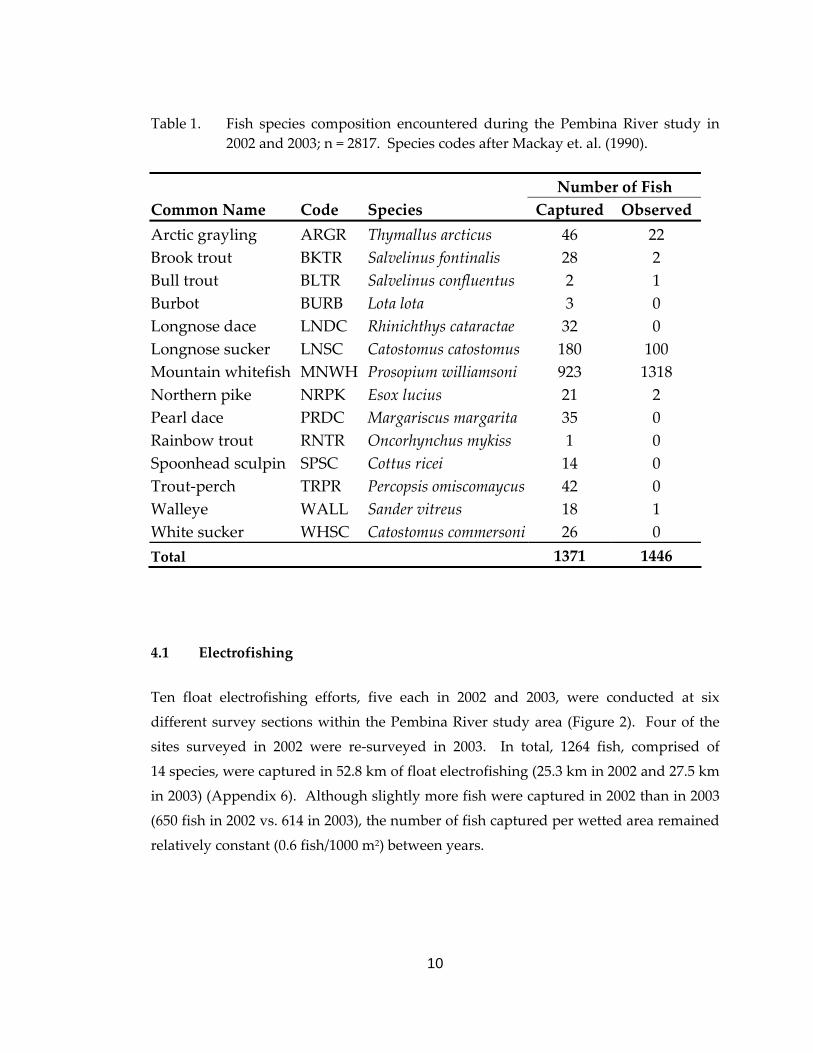
Table 1. Fish species composition encountered during the Pembina River study in 2002 and 2003; n = 2817. Species codes after Mackay et. al. (1990).
Number of Fish Common Name Code Species Captured Observed Arctic grayling ARGR Thymallus arcticus 46 22 Brook trout BKTR Salvelinus fontinalis 28 2 Bull trout BLTR Salvelinus confluentus 2 1 Burbot BURB Lota lota 3 0 Longnose dace LNDC Rhinichthys cataractae 32 0 Longnose sucker LNSC Catostomus catostomus 180 100 Mountain whitefish MNWH Prosopium williamsoni 923 1318 Northern pike NRPK Esox lucius 21 2 Pearl dace PRDC Margariscus margarita 35 0 Rainbow trout RNTR Oncorhynchus mykiss 1 0 Spoonhead sculpin SPSC Cottus ricei 14 0 Trout‐perch TRPR Percopsis omiscomaycus 42 0 Walleye WALL Sander vitreus 18 1 White sucker WHSC Catostomus commersoni 26 0 Total 1371 1446
4.1 Electrofishing
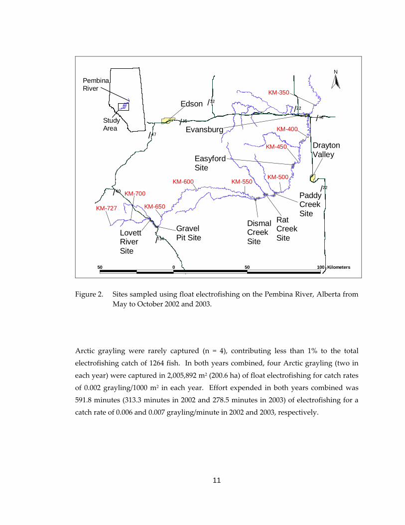
Ten float electrofishing efforts, five each in 2002 and 2003, were conducted at six
different survey sections within the Pembina River study area (Figure 2). Four of the
sites surveyed in 2002 were re‐surveyed in 2003. In total, 1264 fish, comprised of
14 species, were captured in 52.8 km of float electrofishing (25.3 km in 2002 and 27.5 km
in 2003) (Appendix 6). Although slightly more fish were captured in 2002 than in 2003
(650 fish in 2002 vs. 614 in 2003), the number of fish captured per wetted area remained
relatively constant (0.6 fish/1000 m2) between years.
11
KM-727#
KM-700
#
KM-650
#
KM-600#
KM-550#
KM-500
#
KM-450
#
KM-400
#
KM-350
#
Edson
#
DraytonValley
#
DismalCreekSite
# GravelPit Site
#
LovettRiverSite
#
RatCreekSite
# PaddyCreekSite
#
EasyfordSite
#
#
Evansburg
(/32
(/16
(/47
(/40 (/22
(/16(/22
(/734
50 0 50 100 Kilometers
#
PembinaRiver
StudyArea
N
Figure 2. Sites sampled using float electrofishing on the Pembina River, Alberta from
May to October 2002 and 2003.
Arctic grayling were rarely captured (n = 4), contributing less than 1% to the total
electrofishing catch of 1264 fish. In both years combined, four Arctic grayling (two in
each year) were captured in 2,005,892 m2 (200.6 ha) of float electrofishing for catch rates
of 0.002 grayling/1000 m2 in each year. Effort expended in both years combined was
591.8 minutes (313.3 minutes in 2002 and 278.5 minutes in 2003) of electrofishing for a
catch rate of 0.006 and 0.007 grayling/minute in 2002 and 2003, respectively.
12
4.2 Angling
Eleven angling events, five in 2002 and six in 2003, were conducted at 10 different
survey sites (one section sampled twice) (Figure 3). In total, 107 fish comprised of three
species (Arctic grayling, mountain whitefish, and brook trout), were captured in
56.5 hours (22.7 km) of angling (Appendix 7).
'
KM-727#
KM-700
#
KM-650
#
KM-600
#
KM-550#
KM-500
#
KM-450
#
KM-400
#
KM-350
#
Edson
#
DraytonValley
#
Site #3
#
Site #2
#
Site #1
#
Site #4
#
Site #5#
Site #6
#
Site #7#
Site #8
#
Site #9
#
Site #10
#
Site #11
#
Evansburg
(/32
(/16
(/47
(/40
(/734
(/22
(/16(/22
50 0 50 100 Kilometers
#
PembinaRiver
StudyArea
N
Figure 3. Sites angled as part of the Arctic grayling population assessment conducted
on the Pembina River, Alberta in June to October 2002 and 2003. Sites were numbered in the order in which they were sampled, not where they are located on the river.
13
Arctic grayling accounted for 39% of the total angled catch (n = 107). In total, 42 Arctic
grayling were captured (24 in 2002 and 18 in 2003) for catch rates of 1.04 and
0.54 grayling/hour in 2002 and 2003, respectively. Thirty‐three of the 42 graylings (79%)
were captured in a single pool (km‐616) immediately downstream of a bridge crossing
during three separate sampling events (sites #4, #7, and #9 – one site recorded for each
sampling event) (Figure 3). When data collected from this one pool were eliminated,
the catch rates for Arctic grayling were 0.45 grayling/hour in 2002 and zero in 2003.
4.3 Snorkelling
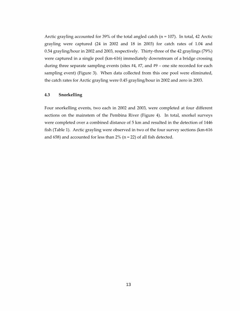
Four snorkelling events, two each in 2002 and 2003, were completed at four different
sections on the mainstem of the Pembina River (Figure 4). In total, snorkel surveys
were completed over a combined distance of 5 km and resulted in the detection of 1446
fish (Table 1). Arctic grayling were observed in two of the four survey sections (km‐616
and 658) and accounted for less than 2% (n = 22) of all fish detected.
14
#Y
KM-727#
KM-700
#
KM-650
#
KM-600#
KM-550#
KM-500
#
KM-450
#
KM-400
#
KM-350
#
Edson
#
DraytonValley
#
#
Evansburg
(/32
(/16
(/47
(/40 (/22
(/16(/22
(/734#Y
#Y
#Y
#
Snorkel site
#
Snorkel site
#
Snorkel site
#
Snorkel site
50 0 50 100 Kilometers
#
PembinaRiver
StudyArea
N
Figure 4. Snorkelling sites on the Pembina River, Alberta during June to October in
2002 and 2003. The two upstream sites (KM‐673 and 658) were sampled in 2002, the two downstream sites (KM‐616 and 580) in 2003.
4.4. Size distribution of Arctic grayling
Size (FL) of Arctic grayling (electrofishing and angling combined) ranged from 115 to
339 mm with a mean of 213 mm (s = 47.6, n = 44) (Figure 5). The relationship between
FL and TL of Arctic grayling in the Pembina River was: TL = 1.09(FL) + 0.9774
(r2 = 0.9992; n = 11) (Appendix 8). As TL was not collected from each grayling captured,
we applied the regression equation and determined that the FL of a “legal sized” Arctic
grayling (i.e., 350 mm TL) was 321 mm. A previous study on the Little Smoky River
reported the same value i.e., 321 mm FL (Sterling and Hunt 1989). Based on this FL
estimate, only two of the 46 fish were large enough to be legally harvested by anglers.
15
012345678910
100 150 200 250 300 350Fork Length (mm)
# of Fish capturedured
Electrofishing Angling
Figure 5. Fork length frequency distribution of Arctic grayling captured from the
Pembina River, Alberta in 2002 and 2003 using angling and electrofishing.
4.5 Age composition of Arctic grayling
Age of Arctic grayling in the study area ranged from 1 to 3 years (FL = 125‐280 mm)
with a mean age of 1.55 years (s = 45.3, n = 20). Mean size‐at‐age was 172.9 mm (s =
26.9, n = 10) for age 1 fish, 244.6 mm (s = 19.0, n = 9) for age 2 fish, and 280 mm (n = 1)
for age 3 (Figure 6) with ages 1 and 2 fish comprising 95% of the sample. All grayling
that were not aged had FLs within the range of the aged fish (125 ‐ 280 mm) with two
exceptions (Figure 5). This suggests that the majority of the captured Arctic grayling
(n = 42) were likely 1‐2 years of age. Based on the length‐at‐age analysis, the larger
graylings (329 and 339 mm) were likely ≥4 years old.
16
50
100
150
200
250
300
0 1 2 3 4Age (years)
Fork Length (m
m)
Figure 6. Fork length‐at‐age of Arctic grayling captured from the Pembina River,
Alberta in 2002 and 2003 (n = 20).
4.6 Distribution of Arctic grayling
Arctic grayling were captured at six of the 16 sampled river sections (Figure 7). These
six sites were located between the mouth of the Lovett River (km‐679) and 150 m
downstream of the mouth of Dismal Creek (km‐536); 95% of the captures were
upstream of the Wolf Lake Road crossing (km‐579). However, grayling that were large
enough to be harvested legally by anglers (n = 2) were found immediately downstream
of the Wolf Lake Road crossing. Because few Arctic grayling were captured and sites
were not re‐sampled, seasonal use of the Pembina River mainstem could not be
determined.
17
#Y
#Y
#
BKTRMNWHRNTR
#
MNWHBKTR
#
BKTRBLTRBURBMNWH
# NOFISHCAUGHT
#
MNWHNRPKWALL
#
NOFISHCAUGHT
#
MNWH
#
MNWH
#
BURBMNWHNRPKWALL
#
MNWHNRPKWALL
#
BURBMNWHNRPKWALL
#
MNWHWALL
ARGR
ARGRARGR
ARGR
#
Edson
#
Drayton Valley
ARGR
#
#
#
BKTRMNWH
ARGR
30 0 30 60 90 Kilometers
Angle sectionsFloat electrofishing sections
#Y Single point angle sites N
PembinaRiverStudy Area
Figure 7. Distribution of Arctic grayling and other sport fish species captured during
angling and electrofishing events or observed during snorkelling events in the Pembina River, Alberta in June to October 2002 and 2003. Fish species codes follow Mackay et al. (1990) and are: Arctic grayling = ARGR, bull trout = BLTR, mountain whitefish = MNWH, rainbow trout = RNTR, brook trout=BKTR, northern pike=NRPK, burbot = BURB, and walleye= WALL.
4.7 Water temperature data
Temperature monitoring locations are presented in Appendix 9 for 2002 and 2003.
Charts were created displaying daily maximum temperatures at each site
(Appendix 10). Daily maximum temperatures in 2003 were not reported for sites #2 or
#8 (Appendix 9) because the data logger at Site #2 was discovered on the riverbank and
the data logger at Site #8 was missing. During both years, daily maximum water
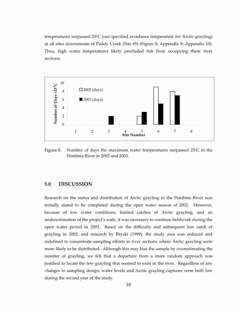
18
temperatures surpassed 25oC (our specified avoidance temperature for Arctic grayling)
at all sites downstream of Paddy Creek (Site #5) (Figure 8; Appendix 9; Appendix 10).
Thus, high water temperatures likely precluded fish from occupying these river
sections.
0
2
4
6
8
10
1 2 3 4 5 6 7 8Site Number
Number of Days >25oC
2002 (days)
2003 (days)
Figure 8. Number of days the maximum water temperatures surpassed 25oC in the
Pembina River in 2002 and 2003.
5.0 DISCUSSION
Research on the status and distribution of Arctic grayling in the Pembina River was
initially slated to be completed during the open water season of 2002. However,
because of low water conditions, limited catches of Arctic grayling, and an
underestimation of the project’s scale, it was necessary to continue fieldwork during the
open water period in 2003. Based on the difficulty and subsequent low catch of
grayling in 2002, and research by Bryski (1999), the study area was reduced and
redefined to concentrate sampling efforts in river sections where Arctic grayling were
more likely to be distributed. Although this may bias the sample by overestimating the
number of grayling, we felt that a departure from a more random approach was
justified to locate the few grayling that seemed to exist in the river. Regardless of any
changes to sampling design, water levels and Arctic grayling captures were both low
during the second year of the study.
19
Float electrofishing catch rates of Arctic grayling in the Pembina River during 2002 and
2003 were relatively low when compared to historical rates. Historically, Arctic
grayling were considered common throughout the mid to upper reaches of the
Pembina River mainstem with reported electrofishing catch rates that ranged from 0.5
to 1.0 grayling/minute (Bryski 1999). Thus, the 2002 and 2003 catch rates of
0.006 grayling/minute and 0.007 grayling/minute, respectively were considered to be
poor.
When angling catch rates in the Pembina River (2002 and 2003) were compared to
historical rates, they appeared to be only moderately depressed. Historically angler
catch rate were reported as 1.0 ‐ 3.0 grayling/hour in the Pembina River prior to the
1970s (Bryski 1999). However, the catch rates of 1.04 grayling/hour in 2002 and
0.54 grayling/hour in 2003 were inflated because three angling events occurred in a
single pool where Arctic grayling were known to stage in the late summer, thus, biasing
the sample and likely overestimating the overall catch rate. This pool was targeted to
compensate for the lack of Arctic grayling biological data collected in the remainder of
the study area. By omitting the data collected from this one pool, catch rates decreased
to 0.45 grayling/hour in 2002 and 0.0 grayling/hour in 2003.
Summer water temperatures may have contributed to the distribution of Arctic
grayling stocks in the Pembina River. The distribution of salmonids within watersheds
is influenced by water temperature (Dunham et. al. 2003; Paul and Post 2001; Rieman
et. al. 1997) and can be used to determine suitable thermal habitats for Arctic grayling
(Lohr et. al. 1996). Lohr et. al. (1996) reported the upper ultimate incipient lethal
temperature – the most extreme temperature an organism can attain by acclimation –
for Arctic grayling as 25oC when acclimated to 20oC. In our study, all captures of Arctic
grayling occurred upstream of the Pembina River‐Paddy Creek confluence (Site #5
Figure 3) where water temperatures were greater than 25oC, suggesting that
behavioural avoidance of extreme temperatures may have influenced the distribution
of Arctic grayling in the Pembina River.
The most effective method used to capture Arctic grayling was angling. All angled
grayling were captured within close proximity to a road access and the majority of the
Arctic grayling were captured in a pool immediately downstream of one road crossing
20
where the fish were easily observed from the bridge deck. Since Arctic grayling are
vulnerable to moderate amounts of angling (Nelson and Paetz 1992) and all the
grayling captured during this study were in close proximity to a road suggests that
Arctic grayling are extremely vulnerable to angling within the Pembina River study
area.
Although it is probable that grayling are present in the unsampled sections of the
Pembina River, it is unlikely that they were present in any significant numbers. If Arctic
grayling were present in the Pembina River in large numbers, sampling efforts in 2002
and 2003 would have detected them. The extremely low water conditions likely caused
fish to congregate in smaller areas, making them more vulnerable to capture. It is also
possible that low water conditions in the river may have caused grayling to seek refuge
in the tributaries where water temperatures may have been cooler and instream cover
may have been more abundant. However, recent stream inventory efforts in Dismal
(McLeod and Gardiner 1999), Rat (Campbell and McLeod 2002), and Paddy Creeks
(Rasmussen and Johnson 2003), main tributaries to the Pembina River, captured very
few or no Arctic grayling.
During the present study, very few Arctic grayling were captured or observed in the
Pembina River. Those that were captured showed a narrow age (ages 1‐3) and size‐
class distribution and low electrofishing and angling catch rates, which were
characterized by a limited spawning stock (grayling > 330 mm TL; see Berry 1998), a
low proportion of older fish in the catch, and generally low numbers of younger fish
(i.e., reduced recruitment); especially when compared to other studies (Ripley 1997;
R.L.&L. Environmental Services Ltd. 1996; Sullivan and Johnson 1994). This suggests
that the Arctic grayling stocks in the Pembina River may be collapsed.
It is unknown what effect human‐use has had on the Arctic grayling population in the
Pembina River. Although forest harvest, oil and gas exploration and extraction, and
agriculture are present in the study area, their level of activity and effects has not been
quantified. Nonetheless, any program implemented to conserve this native population
of Arctic grayling in the Pembina River should consider all forms of human‐use, their
potential effects on the Arctic grayling populations and how these effects could be
mitigated.
21
6.0 REFERENCES Alberta Environment. 2003 Alberta’s River Basins. Online, Internet. Alberta
Environment. http://www3.gov.ab.ca/env/water/basins/basinform.cfm.
Alberta Environment. 2002. Alberta’s River Basins. Online, Internet. Alberta
Environment. http://www3.gov.ab.ca/env/water/basins/basinform.cfm.
Alberta Government. 2003. 2003 guide to Alberta sportfishing regulations. Sports
Scene Publications Inc., Edmonton, Alberta, Canada.
Alberta Government. 1998, 1998 guide to Alberta sportfishing regulations. Alberta
Environmental Protection, Natural Resources Service, Edmonton, Alberta,
Canada.
Antoniuk, T.M., and P. Carey. 1979. Interim report on the foothills project aquatic
baseline assessment, 1978. Prepared for Gulf Canada Resources Inc., Calgary,
Alberta, Canada.
Berry, D.K. 1998. Alberta’s Arctic grayling management and recovery plan. Alberta
Environmental Protection, Natural Resources Service, Alberta, Canada.
Fisheries Management Division. 27 pp.
Bryski, M. 1999. Arctic grayling historical review‐ grayling fisheries of the Pembina
River sub‐basin in fisheries management area 4. Report for Alberta
Environmental Protection, Natural Resources Service, Fisheries Management
Division and the Alberta Conservation Association, Alberta, Canada. (Draft
report). 43 pp. +app.
Campbell, D., and C. McLeod. 2002. Northern East Slopes Co‐operative Fisheries
Inventory Program (CFIP) 2001/2002 Annual Report for Paddle River, Poison
Creek, and Rat Creek Drainages. 28 pp. +app.
22
Dickson, T.A., and P.J. McCart. 1980. Interim report‐fish populations in the vicinity of
the proposed pipeline sites on the Pembina River and Dismal Creek. Prepared
for Hudson’s Bay Oil and Gas Company Ltd. by Aquatic Environments Ltd.,
Calgary. Alberta, Canada. 26 pp.
Dunham, J., B. Rieman, and G. Chandler. 2003. Influences of temperature and
environmental variables on the distribution of bull trout within streams at
southern margin of its range. North American Journal of Fisheries
Management. 23:894‐904.
Foothills Model Forest. 1998. 1998 Fish and stream inventory‐site summaries.
Prepared for the Alberta Conservation Association, Weldwood of Canada
(Hinton Division), and Alberta Sustainable Resource Development. Foothills
Model Forest, Hinton, Alberta.
Huges, R.M., P.R. Kaufmann, A.T. Herlihy, S.S. Intelmann, S.C. Corbett, M.C. Arbogast,
and R.C. Hjort. 2002. Electrofishing distance needed to estimate fish species
richness in raftable Oregon Rivers. North American Journal of Fisheries
Management 22:1229‐1240.
Ledig, B., G. Thorsley, M. Watson, and K. Zelt. 1998. Fisheries Management
Information System (FMIS) user manual. Alberta Environmental Protection,
Natural Resources Service, Alberta, Canada. Fisheries Management Division.
33 pp.
Lohr. S.C., P.A. Byorth, C.M., Kaya, and W.P. Dwyer. 1996. High‐temperature
tolerances of fluvial Arctic grayling and comparisons with summer river
temperatures of the Big Hole River, Montana. Transactions of the American
Fisheries Society. 125:933‐939.
Mackay, W.C., G.R. Ash, and H.J. Norris (eds.). 1990. Fish aging methods for Alberta.
R.L. & L. Environmental Services Ltd. in association with Alberta Fish and
Wildlife Division and University of Alberta, Edmonton, Canada. 113 pp.
23
McLeod, C., and K. Gardiner. 1999. Rocky Mountain House and Nordegg districts co‐
operative fisheries inventory program (CFIP) 1998 annual report. Produced by
the Alberta Conservation Association, Rocky Mountain House, Alberta, Canada.
47 pp. +app.
Minnesota Department of Natural Resources. DNR Garmin Extension for ArcView,
2003. Online, Internet. Minnesota Department of Natural Resources.
http://www.dnr.state.mn.us/mis/gis/tools/arcview/extensions/DNRGarmin/DN
RGarmin.html.
Nelson, J.S., and M.J. Paetz. 1992. The fishes of Alberta. 2nd Edition. The University of
Alberta Press and the University of Calgary Press. 437 pp.
Paul, A.J., and J.R. Post. 2001. Spatial distribution of native and nonnative salmonids
in streams of the eastern slopes of the Canadian Rocky Mountains. Transactions
of the American Fisheries Society. 130:417‐430.
Rasmussen, C., and C. Johnson. 2003. Edson and area co‐operative fisheries inventory
project 2003/2004 annual report. Produced by the Alberta Conservation
Association, Edson, Alberta, Canada. 19 pp. +app.
R.L. & L. Environmental Services Ltd. 1996. Population status and seasonal
distribution of Arctic grayling in the House River Drainage of Northeastern
Alberta, 1995. Prepared for Alberta Environmental Protection, Natural
Resource Service, Fisheries Management Division, Lac La Biche, Alberta. R.L. &
L. Report No. 460F:50 pp. +5 app.
Renewable Resources Consulting Services Ltd. 1971. An ecological study of wildlife
and fisheries in the Pembina and Sturgeon River Basins. Prepared for Water
Resources Division, Alberta Department of the Environment. 333 pp.
Rice, S.P., M.T. Greenwood, and C.B. Joyce. 2001. Tributaries, sediment sources, and
the longitudinal organisation of macroinvertebrate fauna along river systems.
Canadian Journal of Aquatic Sciences. 58:824‐840.
24
Rieman, B.E., D.C. Lee, and R.F. Thurow. 1997. Distribution, status, and likely future
trends of bull trout within the Columbia River and Klamath River Basins. North
American Journal of Fisheries Management. 17:1111‐1125.
Ripley, T. 1997. A stock assessment of the Kakwa River Arctic grayling (Thymallus
arcticus) population, fall 1997. Produced by the Alberta Conservation
Association. Northwest Boreal Region. 23 pp.
Scott, W.B., and E.J. Crossman. 1973. Freshwater fishes of Canada. Bulletin 184,
Fisheries Research Board of Canada, Ottawa, 966 pp.
Stanislawski, S.S., and R.S. Brown. 1997. Spring movements of and spawning habitat
selection by Arctic grayling (Thymallus arcticus (Pallas)) in the Little Smoky
River Drainage, Alberta. Produced by FRM Environmental Consulting Ltd.,
Edmonton, Alberta. 116 pp.
Sterling, G., and C. Hunt. 1989. Preliminary survey; Arctic grayling movements and
age & growth in the Little Smoky River, Alberta, 1987 & 1988. Alberta Forestry,
Lands and Wildlife. Fish and Wildlife Division. East Slopes Region. 53 pp.
Strong, W.L., and K.R. Leggat. 1992. Ecoregions of Alberta. Alberta Forestry, Lands,
and Wildlife, Land Information Services Division, Resource Information Branch,
Edmonton, Alberta.
Sullivan, M., and C. Johnson. 1994. Arctic grayling sampled from the Little Smoky
River, August 1994. Alberta Fish and Wildlife Division memorandum (20
September 1994). 8 pp.
Thurow, R.F. 1994. Underwater methods for study of salmonids in the Intermountain
West. General Technical Report INT‐GTR‐307. Ogden, UT: U.S. Department of
Agriculture, Forest Service, Intermountain Research Station. 28 pp.

25
Wallace, R.R., and P.J. McCart. 1984. The fish and fisheries of the Athabasca River
Basin‐ their status and environmental requirements. For Planning Division,
Alberta Environment, Edmonton. 269 pp. +app.
26
7.0 APPENDIX
Appendix 1. Gradient or slope profile (meters above sea level) of the 2002‐2003 study sites on the Pembina River, Alberta.
600
800
1000
1200
1400
1600
1800
0 50000 100000 150000 200000 250000 300000 350000 400000Distance from River Headwaters (km)
Elevation (m)
Pembina ProfileElectrofishing and Angling sites
50 100 150 200 250 300 350 400
27
Appendix 2. Pembina River fish capture record form.
Page ____ of ____
# Species
Fork Length (mm)
Weight (g)
Sex/ Maturity
Location
Capture method
Recap (y/n)
Old adipose clip
(y/n)
Dorsal #
Adipose clip today
(y/n)
Previous PIT (y/n)
PIT tag # Comments
12345b b b b b b b b b b b b b b
4950* Sex: Male (M), Female (F), or Unknown (U). If there is any doubt, put unknown.** Maturity: Immature, Mature, Ripe, Spent, or Unknown.*** Capture Methods: EF = backpack, FS = float shock, AN = angled, MT = minnow trap, GN = gill net, FF = fish fence
Fish Capture Record FormSite ID: __________ Date: _________________ Waterbody: _____________________
28
Appendix 3. Pembina River float‐electrofishing data form.
Waterbody Name:
Crew (EF) :
Turbidity:Stage:
Day Month YearSurvey Date
Access : Truck/Quad/Heli/Raft/Jet boat
Pembina River Project – Float dataform
Species Number
Fish Summary
Site ID:
EF SettingsRangeDCPercent Amperage
Comments:
Start StopTimeWater TempAir Temp
Transect Easting Northing Wetted Rooted Seconds Distance (m)U/S 0 0T1T2T3T4T5T6T7T8T9T10T11T12T13T14T15T16
UTM (NAD 83, zone 11) Widths (m) Electrofishing effort
Access Easting NorthingPut InTake Out
Site Name:
29
Appendix 4. Pembina River flow data recorded by Alberta Environment (http://www3.gov.ab.ca/env/water/basins/basinform.cfm) near the Town of Entwistle Alberta in 2002 and 2003 (Alberta Environment 2002, 2003) are shown in separate figures below. Entwistle is located at the downstream end of the study area.
River flow data recorded for the Pembina River near the downstream end of the study area, near Entwistle Alberta in 2002 (Alberta Environment 2002).
30
River flow data recorded for the Pembina River at the downstream end of the study area, near Entwistle Alberta in 2003 (Alberta Environment 2003).
31
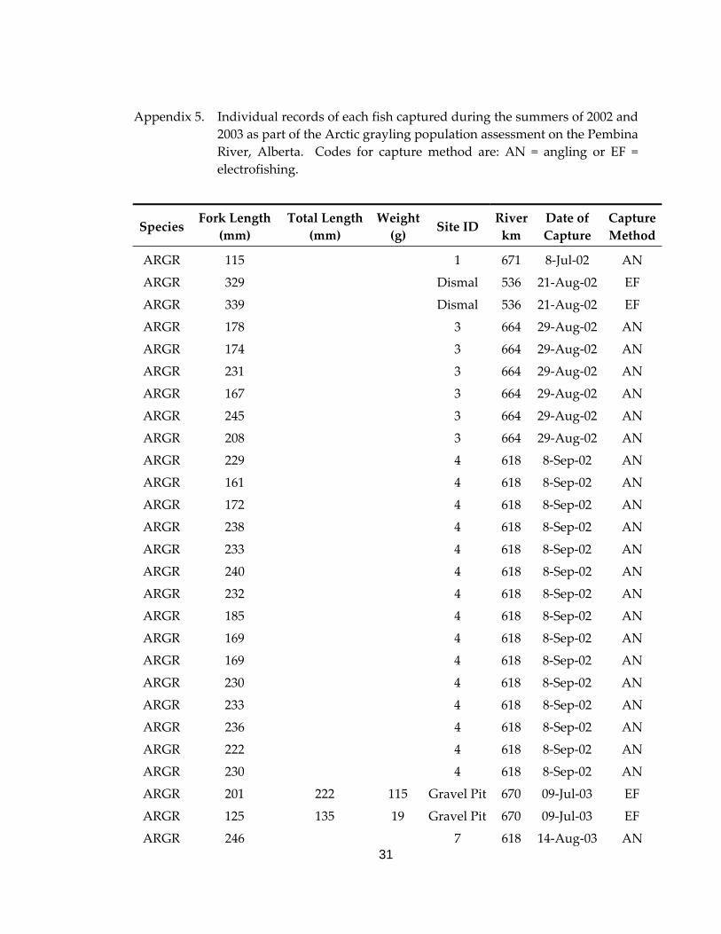
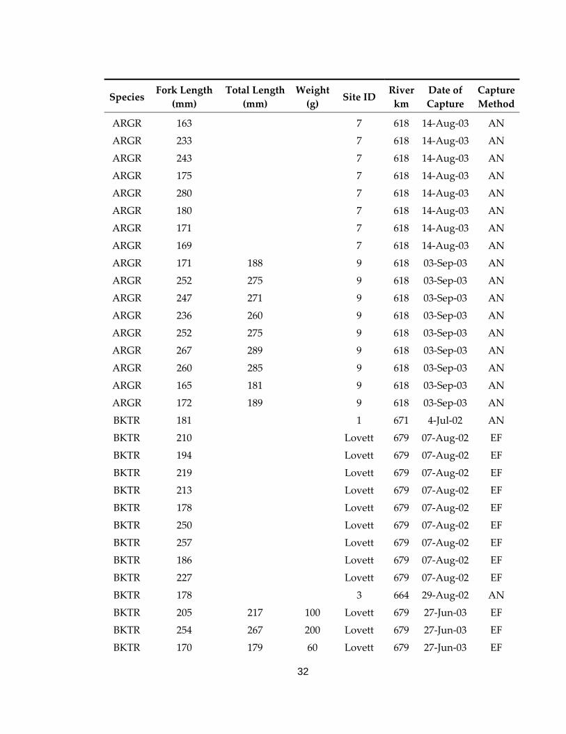
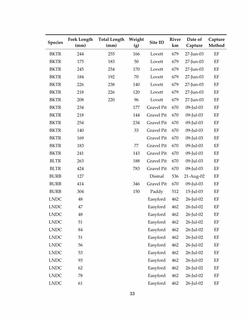
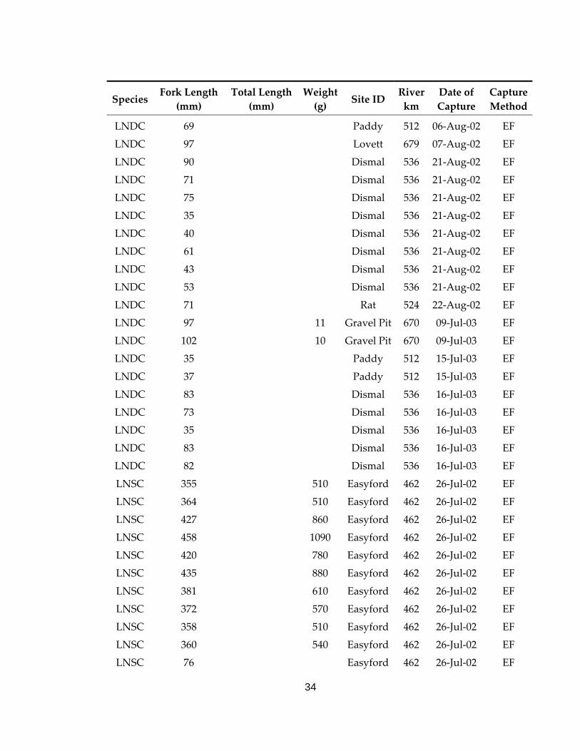
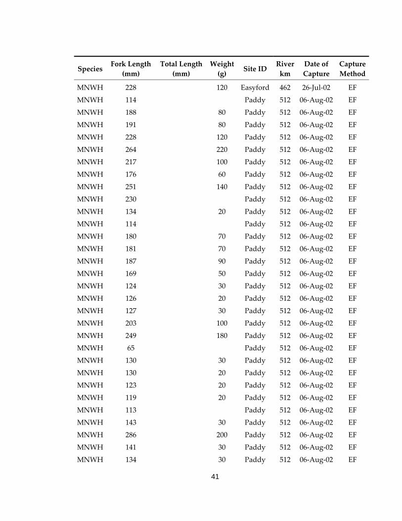
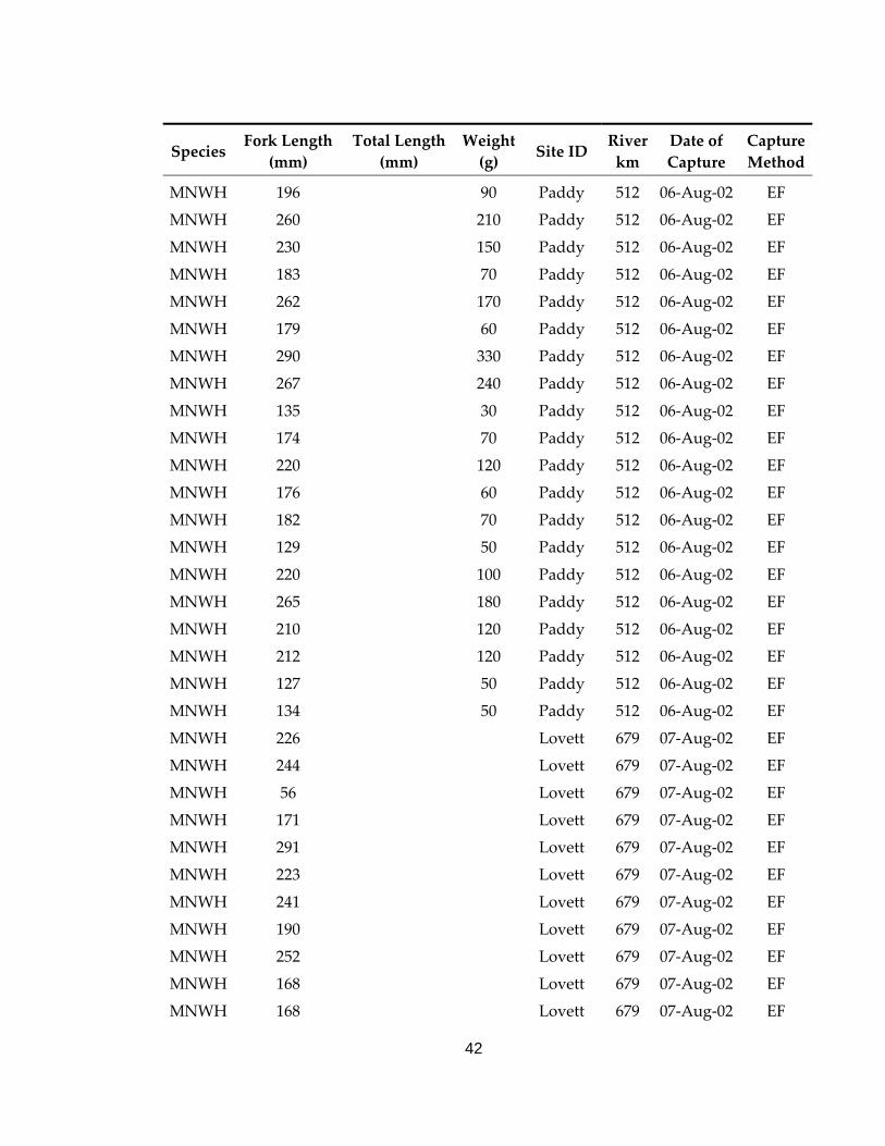
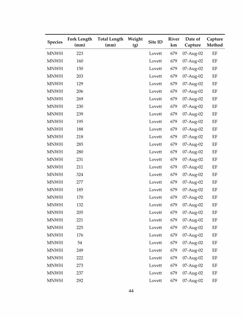
Appendix 5. Individual records of each fish captured during the summers of 2002 and 2003 as part of the Arctic grayling population assessment on the Pembina River, Alberta. Codes for capture method are: AN = angling or EF = electrofishing.
Species Fork Length
(mm) Total Length
(mm) Weight (g) Site ID
River km
Date of Capture
Capture Method
ARGR 115 1 671 8‐Jul‐02 AN
ARGR 329 Dismal 536 21‐Aug‐02 EF
ARGR 339 Dismal 536 21‐Aug‐02 EF
ARGR 178 3 664 29‐Aug‐02 AN
ARGR 174 3 664 29‐Aug‐02 AN
ARGR 231 3 664 29‐Aug‐02 AN
ARGR 167 3 664 29‐Aug‐02 AN
ARGR 245 3 664 29‐Aug‐02 AN
ARGR 208 3 664 29‐Aug‐02 AN
ARGR 229 4 618 8‐Sep‐02 AN
ARGR 161 4 618 8‐Sep‐02 AN
ARGR 172 4 618 8‐Sep‐02 AN
ARGR 238 4 618 8‐Sep‐02 AN
ARGR 233 4 618 8‐Sep‐02 AN
ARGR 240 4 618 8‐Sep‐02 AN
ARGR 232 4 618 8‐Sep‐02 AN
ARGR 185 4 618 8‐Sep‐02 AN
ARGR 169 4 618 8‐Sep‐02 AN
ARGR 169 4 618 8‐Sep‐02 AN
ARGR 230 4 618 8‐Sep‐02 AN
ARGR 233 4 618 8‐Sep‐02 AN
ARGR 236 4 618 8‐Sep‐02 AN
ARGR 222 4 618 8‐Sep‐02 AN
ARGR 230 4 618 8‐Sep‐02 AN
ARGR 201 222 115 Gravel Pit 670 09‐Jul‐03 EF
ARGR 125 135 19 Gravel Pit 670 09‐Jul‐03 EF
ARGR 246 7 618 14‐Aug‐03 AN
32
Species Fork Length
(mm) Total Length
(mm) Weight (g) Site ID
River km
Date of Capture
Capture Method
ARGR 163 7 618 14‐Aug‐03 AN
ARGR 233 7 618 14‐Aug‐03 AN
ARGR 243 7 618 14‐Aug‐03 AN
ARGR 175 7 618 14‐Aug‐03 AN
ARGR 280 7 618 14‐Aug‐03 AN
ARGR 180 7 618 14‐Aug‐03 AN
ARGR 171 7 618 14‐Aug‐03 AN
ARGR 169 7 618 14‐Aug‐03 AN
ARGR 171 188 9 618 03‐Sep‐03 AN
ARGR 252 275 9 618 03‐Sep‐03 AN
ARGR 247 271 9 618 03‐Sep‐03 AN
ARGR 236 260 9 618 03‐Sep‐03 AN
ARGR 252 275 9 618 03‐Sep‐03 AN
ARGR 267 289 9 618 03‐Sep‐03 AN
ARGR 260 285 9 618 03‐Sep‐03 AN
ARGR 165 181 9 618 03‐Sep‐03 AN
ARGR 172 189 9 618 03‐Sep‐03 AN
BKTR 181 1 671 4‐Jul‐02 AN
BKTR 210 Lovett 679 07‐Aug‐02 EF
BKTR 194 Lovett 679 07‐Aug‐02 EF
BKTR 219 Lovett 679 07‐Aug‐02 EF
BKTR 213 Lovett 679 07‐Aug‐02 EF
BKTR 178 Lovett 679 07‐Aug‐02 EF
BKTR 250 Lovett 679 07‐Aug‐02 EF
BKTR 257 Lovett 679 07‐Aug‐02 EF
BKTR 186 Lovett 679 07‐Aug‐02 EF
BKTR 227 Lovett 679 07‐Aug‐02 EF
BKTR 178 3 664 29‐Aug‐02 AN
BKTR 205 217 100 Lovett 679 27‐Jun‐03 EF
BKTR 254 267 200 Lovett 679 27‐Jun‐03 EF
BKTR 170 179 60 Lovett 679 27‐Jun‐03 EF
33
Species Fork Length
(mm) Total Length
(mm) Weight (g) Site ID
River km
Date of Capture
Capture Method
BKTR 244 255 166 Lovett 679 27‐Jun‐03 EF
BKTR 175 183 50 Lovett 679 27‐Jun‐03 EF
BKTR 245 254 170 Lovett 679 27‐Jun‐03 EF
BKTR 184 192 70 Lovett 679 27‐Jun‐03 EF
BKTR 226 238 140 Lovett 679 27‐Jun‐03 EF
BKTR 218 226 120 Lovett 679 27‐Jun‐03 EF
BKTR 208 220 96 Lovett 679 27‐Jun‐03 EF
BKTR 234 177 Gravel Pit 670 09‐Jul‐03 EF
BKTR 218 144 Gravel Pit 670 09‐Jul‐03 EF
BKTR 254 234 Gravel Pit 670 09‐Jul‐03 EF
BKTR 140 33 Gravel Pit 670 09‐Jul‐03 EF
BKTR 169 Gravel Pit 670 09‐Jul‐03 EF
BKTR 183 77 Gravel Pit 670 09‐Jul‐03 EF
BKTR 241 143 Gravel Pit 670 09‐Jul‐03 EF
BLTR 263 188 Gravel Pit 670 09‐Jul‐03 EF
BLTR 424 783 Gravel Pit 670 09‐Jul‐03 EF
BURB 127 Dismal 536 21‐Aug‐02 EF
BURB 414 346 Gravel Pit 670 09‐Jul‐03 EF
BURB 304 150 Paddy 512 15‐Jul‐03 EF
LNDC 48 Easyford 462 26‐Jul‐02 EF
LNDC 47 Easyford 462 26‐Jul‐02 EF
LNDC 48 Easyford 462 26‐Jul‐02 EF
LNDC 51 Easyford 462 26‐Jul‐02 EF
LNDC 84 Easyford 462 26‐Jul‐02 EF
LNDC 51 Easyford 462 26‐Jul‐02 EF
LNDC 56 Easyford 462 26‐Jul‐02 EF
LNDC 53 Easyford 462 26‐Jul‐02 EF
LNDC 93 Easyford 462 26‐Jul‐02 EF
LNDC 62 Easyford 462 26‐Jul‐02 EF
LNDC 78 Easyford 462 26‐Jul‐02 EF
LNDC 61 Easyford 462 26‐Jul‐02 EF
34
Species Fork Length
(mm) Total Length
(mm) Weight (g) Site ID
River km
Date of Capture
Capture Method
LNDC 69 Paddy 512 06‐Aug‐02 EF
LNDC 97 Lovett 679 07‐Aug‐02 EF
LNDC 90 Dismal 536 21‐Aug‐02 EF
LNDC 71 Dismal 536 21‐Aug‐02 EF
LNDC 75 Dismal 536 21‐Aug‐02 EF
LNDC 35 Dismal 536 21‐Aug‐02 EF
LNDC 40 Dismal 536 21‐Aug‐02 EF
LNDC 61 Dismal 536 21‐Aug‐02 EF
LNDC 43 Dismal 536 21‐Aug‐02 EF
LNDC 53 Dismal 536 21‐Aug‐02 EF
LNDC 71 Rat 524 22‐Aug‐02 EF
LNDC 97 11 Gravel Pit 670 09‐Jul‐03 EF
LNDC 102 10 Gravel Pit 670 09‐Jul‐03 EF
LNDC 35 Paddy 512 15‐Jul‐03 EF
LNDC 37 Paddy 512 15‐Jul‐03 EF
LNDC 83 Dismal 536 16‐Jul‐03 EF
LNDC 73 Dismal 536 16‐Jul‐03 EF
LNDC 35 Dismal 536 16‐Jul‐03 EF
LNDC 83 Dismal 536 16‐Jul‐03 EF
LNDC 82 Dismal 536 16‐Jul‐03 EF
LNSC 355 510 Easyford 462 26‐Jul‐02 EF
LNSC 364 510 Easyford 462 26‐Jul‐02 EF
LNSC 427 860 Easyford 462 26‐Jul‐02 EF
LNSC 458 1090 Easyford 462 26‐Jul‐02 EF
LNSC 420 780 Easyford 462 26‐Jul‐02 EF
LNSC 435 880 Easyford 462 26‐Jul‐02 EF
LNSC 381 610 Easyford 462 26‐Jul‐02 EF
LNSC 372 570 Easyford 462 26‐Jul‐02 EF
LNSC 358 510 Easyford 462 26‐Jul‐02 EF
LNSC 360 540 Easyford 462 26‐Jul‐02 EF
LNSC 76 Easyford 462 26‐Jul‐02 EF

35
Species Fork Length
(mm) Total Length
(mm) Weight (g) Site ID
River km
Date of Capture
Capture Method
LNSC 432 800 Easyford 462 26‐Jul‐02 EF
LNSC 47 Easyford 462 26‐Jul‐02 EF
LNSC 378 620 Easyford 462 26‐Jul‐02 EF
LNSC 99 Easyford 462 26‐Jul‐02 EF
LNSC 104 Easyford 462 26‐Jul‐02 EF
LNSC 115 Easyford 462 26‐Jul‐02 EF
LNSC 101 10 Easyford 462 26‐Jul‐02 EF
LNSC 415 830 Easyford 462 26‐Jul‐02 EF
LNSC 426 740 Easyford 462 26‐Jul‐02 EF
LNSC 392 760 Easyford 462 26‐Jul‐02 EF
LNSC 372 680 Easyford 462 26‐Jul‐02 EF
LNSC 387 680 Easyford 462 26‐Jul‐02 EF
LNSC 410 700 Easyford 462 26‐Jul‐02 EF
LNSC 381 590 Easyford 462 26‐Jul‐02 EF
LNSC 377 620 Easyford 462 26‐Jul‐02 EF
LNSC 384 680 Easyford 462 26‐Jul‐02 EF
LNSC 378 660 Easyford 462 26‐Jul‐02 EF
LNSC 391 600 Easyford 462 26‐Jul‐02 EF
LNSC 68 Easyford 462 26‐Jul‐02 EF
LNSC 416 810 Easyford 462 26‐Jul‐02 EF
LNSC 210 120 Paddy 512 06‐Aug‐02 EF
LNSC 117 30 Paddy 512 06‐Aug‐02 EF
LNSC 383 660 Paddy 512 06‐Aug‐02 EF
LNSC 372 580 Paddy 512 06‐Aug‐02 EF
LNSC 373 680 Paddy 512 06‐Aug‐02 EF
LNSC 118 20 Paddy 512 06‐Aug‐02 EF
LNSC 381 720 Paddy 512 06‐Aug‐02 EF
LNSC 405 770 Paddy 512 06‐Aug‐02 EF
LNSC 390 630 Paddy 512 06‐Aug‐02 EF
LNSC 306 350 Paddy 512 06‐Aug‐02 EF
LNSC 424 850 Paddy 512 06‐Aug‐02 EF

36
Species Fork Length
(mm) Total Length
(mm) Weight (g) Site ID
River km
Date of Capture
Capture Method
LNSC 353 500 Paddy 512 06‐Aug‐02 EF
LNSC 432 Lovett 679 07‐Aug‐02 EF
LNSC 362 Lovett 679 07‐Aug‐02 EF
LNSC 340 Lovett 679 07‐Aug‐02 EF
LNSC 370 Lovett 679 07‐Aug‐02 EF
LNSC 381 Lovett 679 07‐Aug‐02 EF
LNSC 439 Lovett 679 07‐Aug‐02 EF
LNSC 391 Lovett 679 07‐Aug‐02 EF
LNSC 393 Lovett 679 07‐Aug‐02 EF
LNSC 424 Lovett 679 07‐Aug‐02 EF
LNSC 388 Lovett 679 07‐Aug‐02 EF
LNSC 368 Lovett 679 07‐Aug‐02 EF
LNSC 371 Lovett 679 07‐Aug‐02 EF
LNSC 388 Lovett 679 07‐Aug‐02 EF
LNSC 356 Lovett 679 07‐Aug‐02 EF
LNSC 357 Lovett 679 07‐Aug‐02 EF
LNSC 392 Lovett 679 07‐Aug‐02 EF
LNSC 416 Lovett 679 07‐Aug‐02 EF
LNSC 353 Lovett 679 07‐Aug‐02 EF
LNSC 375 Lovett 679 07‐Aug‐02 EF
LNSC 392 Lovett 679 07‐Aug‐02 EF
LNSC 396 Lovett 679 07‐Aug‐02 EF
LNSC 378 Lovett 679 07‐Aug‐02 EF
LNSC 377 Lovett 679 07‐Aug‐02 EF
LNSC 378 Lovett 679 07‐Aug‐02 EF
LNSC 177 Lovett 679 07‐Aug‐02 EF
LNSC 430 Lovett 679 07‐Aug‐02 EF
LNSC 409 Lovett 679 07‐Aug‐02 EF
LNSC 357 Lovett 679 07‐Aug‐02 EF
LNSC 408 Lovett 679 07‐Aug‐02 EF
LNSC 401 Lovett 679 07‐Aug‐02 EF
37
Species Fork Length
(mm) Total Length
(mm) Weight (g) Site ID
River km
Date of Capture
Capture Method
LNSC 450 Lovett 679 07‐Aug‐02 EF
LNSC 401 Lovett 679 07‐Aug‐02 EF
LNSC 359 Dismal 536 21‐Aug‐02 EF
LNSC 319 Dismal 536 21‐Aug‐02 EF
LNSC 379 Dismal 536 21‐Aug‐02 EF
LNSC 345 Dismal 536 21‐Aug‐02 EF
LNSC 394 Dismal 536 21‐Aug‐02 EF
LNSC 384 Dismal 536 21‐Aug‐02 EF
LNSC 330 Dismal 536 21‐Aug‐02 EF
LNSC 341 Dismal 536 21‐Aug‐02 EF
LNSC 354 Dismal 536 21‐Aug‐02 EF
LNSC 68 Dismal 536 21‐Aug‐02 EF
LNSC 309 Dismal 536 21‐Aug‐02 EF
LNSC 90 Dismal 536 21‐Aug‐02 EF
LNSC 103 Dismal 536 21‐Aug‐02 EF
LNSC 357 Dismal 536 21‐Aug‐02 EF
LNSC 374 Dismal 536 21‐Aug‐02 EF
LNSC 339 Dismal 536 21‐Aug‐02 EF
LNSC 352 Dismal 536 21‐Aug‐02 EF
LNSC 394 Dismal 536 21‐Aug‐02 EF
LNSC 68 Dismal 536 21‐Aug‐02 EF
LNSC 387 Dismal 536 21‐Aug‐02 EF
LNSC 389 Dismal 536 21‐Aug‐02 EF
LNSC 358 Dismal 536 21‐Aug‐02 EF
LNSC 342 Dismal 536 21‐Aug‐02 EF
LNSC 69 Dismal 536 21‐Aug‐02 EF
LNSC 89 Dismal 536 21‐Aug‐02 EF
LNSC 281 Dismal 536 21‐Aug‐02 EF
LNSC 422 Dismal 536 21‐Aug‐02 EF
LNSC 351 Dismal 536 21‐Aug‐02 EF
LNSC 364 Dismal 536 21‐Aug‐02 EF
38
Species Fork Length
(mm) Total Length
(mm) Weight (g) Site ID
River km
Date of Capture
Capture Method
LNSC 358 Dismal 536 21‐Aug‐02 EF
LNSC 359 Dismal 536 21‐Aug‐02 EF
LNSC 360 Dismal 536 21‐Aug‐02 EF
LNSC 422 Dismal 536 21‐Aug‐02 EF
LNSC 355 Dismal 536 21‐Aug‐02 EF
LNSC 392 Dismal 536 21‐Aug‐02 EF
LNSC 398 Dismal 536 21‐Aug‐02 EF
LNSC 355 Dismal 536 21‐Aug‐02 EF
LNSC 363 Dismal 536 21‐Aug‐02 EF
LNSC 285 Dismal 536 21‐Aug‐02 EF
LNSC 347 Dismal 536 21‐Aug‐02 EF
LNSC 378 Dismal 536 21‐Aug‐02 EF
LNSC 332 Dismal 536 21‐Aug‐02 EF
LNSC 158 Dismal 536 21‐Aug‐02 EF
LNSC 388 Dismal 536 21‐Aug‐02 EF
LNSC 378 Dismal 536 21‐Aug‐02 EF
LNSC 392 Rat 524 22‐Aug‐02 EF
LNSC 360 Rat 524 22‐Aug‐02 EF
LNSC 359 Rat 524 22‐Aug‐02 EF
LNSC 358 Rat 524 22‐Aug‐02 EF
LNSC 158 Rat 524 22‐Aug‐02 EF
LNSC 378 Rat 524 22‐Aug‐02 EF
LNSC 332 Rat 524 22‐Aug‐02 EF
LNSC 378 Rat 524 22‐Aug‐02 EF
LNSC 388 Rat 524 22‐Aug‐02 EF
LNSC 355 Rat 524 22‐Aug‐02 EF
LNSC 347 Rat 524 22‐Aug‐02 EF
LNSC 422 Rat 524 22‐Aug‐02 EF
LNSC 363 Rat 524 22‐Aug‐02 EF
LNSC 422 Rat 524 22‐Aug‐02 EF
LNSC 285 Rat 524 22‐Aug‐02 EF
39
Species Fork Length
(mm) Total Length
(mm) Weight (g) Site ID
River km
Date of Capture
Capture Method
LNSC 398 Rat 524 22‐Aug‐02 EF
LNSC 355 Rat 524 22‐Aug‐02 EF
LNSC 364 Rat 524 22‐Aug‐02 EF
LNSC 351 Rat 524 22‐Aug‐02 EF
LNSC 372 580 Lovett 679 27‐Jun‐03 EF
LNSC 418 860 Lovett 679 27‐Jun‐03 EF
LNSC 400 847 Lovett 679 27‐Jun‐03 EF
LNSC 335 Lovett 679 27‐Jun‐03 EF
LNSC 416 1028 Lovett 679 27‐Jun‐03 EF
LNSC 399 808 Lovett 679 27‐Jun‐03 EF
LNSC 402 524 Lovett 679 27‐Jun‐03 EF
LNSC 430 1062 Lovett 679 27‐Jun‐03 EF
LNSC 440 1106 Lovett 679 27‐Jun‐03 EF
LNSC 214 110 Lovett 679 27‐Jun‐03 EF
LNSC 403 880 Lovett 679 27‐Jun‐03 EF
LNSC 396 498 Lovett 679 27‐Jun‐03 EF
LNSC 446 1180 Lovett 679 27‐Jun‐03 EF
LNSC 373 680 Lovett 679 27‐Jun‐03 EF
LNSC 385 Gravel Pit 670 09‐Jul‐03 EF
LNSC 182 85.3 Gravel Pit 670 09‐Jul‐03 EF
LNSC 425 1019 Gravel Pit 670 09‐Jul‐03 EF
LNSC 433 Gravel Pit 670 09‐Jul‐03 EF
LNSC 378 Gravel Pit 670 09‐Jul‐03 EF
LNSC 389 Gravel Pit 670 09‐Jul‐03 EF
LNSC 354 509 Gravel Pit 670 09‐Jul‐03 EF
LNSC 432 909 Gravel Pit 670 09‐Jul‐03 EF
LNSC 400 808 Gravel Pit 670 09‐Jul‐03 EF
LNSC 175 70 Gravel Pit 670 09‐Jul‐03 EF
LNSC 238 158 Gravel Pit 670 09‐Jul‐03 EF
LNSC 388 716 Gravel Pit 670 09‐Jul‐03 EF
LNSC 287 246 Gravel Pit 670 09‐Jul‐03 EF
40
Species Fork Length
(mm) Total Length
(mm) Weight (g) Site ID
River km
Date of Capture
Capture Method
LNSC 110 21 Gravel Pit 670 09‐Jul‐03 EF
LNSC 386 631 Gravel Pit 670 09‐Jul‐03 EF
LNSC 402 Gravel Pit 670 09‐Jul‐03 EF
LNSC 390 758 Gravel Pit 670 09‐Jul‐03 EF
LNSC 385 728 Paddy 512 15‐Jul‐03 EF
LNSC 344 Paddy 512 15‐Jul‐03 EF
LNSC 364 531 Dismal 536 16‐Jul‐03 EF
LNSC 389 590 Dismal 536 16‐Jul‐03 EF
LNSC 59 Dismal 536 16‐Jul‐03 EF
LNSC 355 585 Rat 524 17‐Jul‐03 EF
LNSC 339 Rat 524 17‐Jul‐03 EF
LNSC 350 Rat 524 17‐Jul‐03 EF
LNSC 380 696 Rat 524 17‐Jul‐03 EF
LNSC 374 513 Rat 524 17‐Jul‐03 EF
MNWH 237 1 671 5‐Jul‐02 AN
MNWH 239 1 671 6‐Jul‐02 AN
MNWH 249 1 671 7‐Jul‐02 AN
MNWH 132 20 Easyford 462 26‐Jul‐02 EF
MNWH 151 40 Easyford 462 26‐Jul‐02 EF
MNWH 182 65 Easyford 462 26‐Jul‐02 EF
MNWH 201 85 Easyford 462 26‐Jul‐02 EF
MNWH 142 25 Easyford 462 26‐Jul‐02 EF
MNWH 204 90 Easyford 462 26‐Jul‐02 EF
MNWH 178 60 Easyford 462 26‐Jul‐02 EF
MNWH 190 60 Easyford 462 26‐Jul‐02 EF
MNWH 190 80 Easyford 462 26‐Jul‐02 EF
MNWH 245 150 Easyford 462 26‐Jul‐02 EF
MNWH 232 160 Easyford 462 26‐Jul‐02 EF
MNWH 281 270 Easyford 462 26‐Jul‐02 EF
MNWH 152 40 Easyford 462 26‐Jul‐02 EF
MNWH 268 240 Easyford 462 26‐Jul‐02 EF
41
Species Fork Length
(mm) Total Length
(mm) Weight (g) Site ID
River km
Date of Capture
Capture Method
MNWH 228 120 Easyford 462 26‐Jul‐02 EF
MNWH 114 Paddy 512 06‐Aug‐02 EF
MNWH 188 80 Paddy 512 06‐Aug‐02 EF
MNWH 191 80 Paddy 512 06‐Aug‐02 EF
MNWH 228 120 Paddy 512 06‐Aug‐02 EF
MNWH 264 220 Paddy 512 06‐Aug‐02 EF
MNWH 217 100 Paddy 512 06‐Aug‐02 EF
MNWH 176 60 Paddy 512 06‐Aug‐02 EF
MNWH 251 140 Paddy 512 06‐Aug‐02 EF
MNWH 230 Paddy 512 06‐Aug‐02 EF
MNWH 134 20 Paddy 512 06‐Aug‐02 EF
MNWH 114 Paddy 512 06‐Aug‐02 EF
MNWH 180 70 Paddy 512 06‐Aug‐02 EF
MNWH 181 70 Paddy 512 06‐Aug‐02 EF
MNWH 187 90 Paddy 512 06‐Aug‐02 EF
MNWH 169 50 Paddy 512 06‐Aug‐02 EF
MNWH 124 30 Paddy 512 06‐Aug‐02 EF
MNWH 126 20 Paddy 512 06‐Aug‐02 EF
MNWH 127 30 Paddy 512 06‐Aug‐02 EF
MNWH 203 100 Paddy 512 06‐Aug‐02 EF
MNWH 249 180 Paddy 512 06‐Aug‐02 EF
MNWH 65 Paddy 512 06‐Aug‐02 EF
MNWH 130 30 Paddy 512 06‐Aug‐02 EF
MNWH 130 20 Paddy 512 06‐Aug‐02 EF
MNWH 123 20 Paddy 512 06‐Aug‐02 EF
MNWH 119 20 Paddy 512 06‐Aug‐02 EF
MNWH 113 Paddy 512 06‐Aug‐02 EF
MNWH 143 30 Paddy 512 06‐Aug‐02 EF
MNWH 286 200 Paddy 512 06‐Aug‐02 EF
MNWH 141 30 Paddy 512 06‐Aug‐02 EF
MNWH 134 30 Paddy 512 06‐Aug‐02 EF
42
Species Fork Length
(mm) Total Length
(mm) Weight (g) Site ID
River km
Date of Capture
Capture Method
MNWH 196 90 Paddy 512 06‐Aug‐02 EF
MNWH 260 210 Paddy 512 06‐Aug‐02 EF
MNWH 230 150 Paddy 512 06‐Aug‐02 EF
MNWH 183 70 Paddy 512 06‐Aug‐02 EF
MNWH 262 170 Paddy 512 06‐Aug‐02 EF
MNWH 179 60 Paddy 512 06‐Aug‐02 EF
MNWH 290 330 Paddy 512 06‐Aug‐02 EF
MNWH 267 240 Paddy 512 06‐Aug‐02 EF
MNWH 135 30 Paddy 512 06‐Aug‐02 EF
MNWH 174 70 Paddy 512 06‐Aug‐02 EF
MNWH 220 120 Paddy 512 06‐Aug‐02 EF
MNWH 176 60 Paddy 512 06‐Aug‐02 EF
MNWH 182 70 Paddy 512 06‐Aug‐02 EF
MNWH 129 50 Paddy 512 06‐Aug‐02 EF
MNWH 220 100 Paddy 512 06‐Aug‐02 EF
MNWH 265 180 Paddy 512 06‐Aug‐02 EF
MNWH 210 120 Paddy 512 06‐Aug‐02 EF
MNWH 212 120 Paddy 512 06‐Aug‐02 EF
MNWH 127 50 Paddy 512 06‐Aug‐02 EF
MNWH 134 50 Paddy 512 06‐Aug‐02 EF
MNWH 226 Lovett 679 07‐Aug‐02 EF
MNWH 244 Lovett 679 07‐Aug‐02 EF
MNWH 56 Lovett 679 07‐Aug‐02 EF
MNWH 171 Lovett 679 07‐Aug‐02 EF
MNWH 291 Lovett 679 07‐Aug‐02 EF
MNWH 223 Lovett 679 07‐Aug‐02 EF
MNWH 241 Lovett 679 07‐Aug‐02 EF
MNWH 190 Lovett 679 07‐Aug‐02 EF
MNWH 252 Lovett 679 07‐Aug‐02 EF
MNWH 168 Lovett 679 07‐Aug‐02 EF
MNWH 168 Lovett 679 07‐Aug‐02 EF

43
Species Fork Length
(mm) Total Length
(mm) Weight (g) Site ID
River km
Date of Capture
Capture Method
MNWH 226 Lovett 679 07‐Aug‐02 EF
MNWH 200 Lovett 679 07‐Aug‐02 EF
MNWH 225 Lovett 679 07‐Aug‐02 EF
MNWH 273 Lovett 679 07‐Aug‐02 EF
MNWH 166 Lovett 679 07‐Aug‐02 EF
MNWH 205 Lovett 679 07‐Aug‐02 EF
MNWH 234 Lovett 679 07‐Aug‐02 EF
MNWH 239 Lovett 679 07‐Aug‐02 EF
MNWH 275 Lovett 679 07‐Aug‐02 EF
MNWH 160 Lovett 679 07‐Aug‐02 EF
MNWH 163 Lovett 679 07‐Aug‐02 EF
MNWH 226 Lovett 679 07‐Aug‐02 EF
MNWH 231 Lovett 679 07‐Aug‐02 EF
MNWH 163 Lovett 679 07‐Aug‐02 EF
MNWH 220 Lovett 679 07‐Aug‐02 EF
MNWH 180 Lovett 679 07‐Aug‐02 EF
MNWH 165 Lovett 679 07‐Aug‐02 EF
MNWH 248 Lovett 679 07‐Aug‐02 EF
MNWH 248 Lovett 679 07‐Aug‐02 EF
MNWH 143 Lovett 679 07‐Aug‐02 EF
MNWH 174 Lovett 679 07‐Aug‐02 EF
MNWH 178 Lovett 679 07‐Aug‐02 EF
MNWH 134 Lovett 679 07‐Aug‐02 EF
MNWH 275 Lovett 679 07‐Aug‐02 EF
MNWH 258 Lovett 679 07‐Aug‐02 EF
MNWH 196 Lovett 679 07‐Aug‐02 EF
MNWH 156 Lovett 679 07‐Aug‐02 EF
MNWH 227 Lovett 679 07‐Aug‐02 EF
MNWH 182 Lovett 679 07‐Aug‐02 EF
MNWH 172 Lovett 679 07‐Aug‐02 EF
MNWH 220 Lovett 679 07‐Aug‐02 EF
44
Species Fork Length
(mm) Total Length
(mm) Weight (g) Site ID
River km
Date of Capture
Capture Method
MNWH 223 Lovett 679 07‐Aug‐02 EF
MNWH 160 Lovett 679 07‐Aug‐02 EF
MNWH 150 Lovett 679 07‐Aug‐02 EF
MNWH 203 Lovett 679 07‐Aug‐02 EF
MNWH 129 Lovett 679 07‐Aug‐02 EF
MNWH 206 Lovett 679 07‐Aug‐02 EF
MNWH 269 Lovett 679 07‐Aug‐02 EF
MNWH 230 Lovett 679 07‐Aug‐02 EF
MNWH 239 Lovett 679 07‐Aug‐02 EF
MNWH 195 Lovett 679 07‐Aug‐02 EF
MNWH 188 Lovett 679 07‐Aug‐02 EF
MNWH 218 Lovett 679 07‐Aug‐02 EF
MNWH 285 Lovett 679 07‐Aug‐02 EF
MNWH 280 Lovett 679 07‐Aug‐02 EF
MNWH 231 Lovett 679 07‐Aug‐02 EF
MNWH 211 Lovett 679 07‐Aug‐02 EF
MNWH 324 Lovett 679 07‐Aug‐02 EF
MNWH 277 Lovett 679 07‐Aug‐02 EF
MNWH 185 Lovett 679 07‐Aug‐02 EF
MNWH 170 Lovett 679 07‐Aug‐02 EF
MNWH 132 Lovett 679 07‐Aug‐02 EF
MNWH 205 Lovett 679 07‐Aug‐02 EF
MNWH 221 Lovett 679 07‐Aug‐02 EF
MNWH 225 Lovett 679 07‐Aug‐02 EF
MNWH 176 Lovett 679 07‐Aug‐02 EF
MNWH 54 Lovett 679 07‐Aug‐02 EF
MNWH 249 Lovett 679 07‐Aug‐02 EF
MNWH 222 Lovett 679 07‐Aug‐02 EF
MNWH 273 Lovett 679 07‐Aug‐02 EF
MNWH 237 Lovett 679 07‐Aug‐02 EF
MNWH 292 Lovett 679 07‐Aug‐02 EF

45
Species Fork Length
(mm) Total Length
(mm) Weight (g) Site ID
River km
Date of Capture
Capture Method
MNWH 262 Lovett 679 07‐Aug‐02 EF
MNWH 216 Lovett 679 07‐Aug‐02 EF
MNWH 217 Lovett 679 07‐Aug‐02 EF
MNWH 208 Lovett 679 07‐Aug‐02 EF
MNWH 220 Lovett 679 07‐Aug‐02 EF
MNWH 196 Lovett 679 07‐Aug‐02 EF
MNWH 206 Lovett 679 07‐Aug‐02 EF
MNWH 236 Lovett 679 07‐Aug‐02 EF
MNWH 199 Lovett 679 07‐Aug‐02 EF
MNWH 157 Lovett 679 07‐Aug‐02 EF
MNWH 200 Lovett 679 07‐Aug‐02 EF
MNWH 208 Lovett 679 07‐Aug‐02 EF
MNWH 238 Lovett 679 07‐Aug‐02 EF
MNWH 175 Lovett 679 07‐Aug‐02 EF
MNWH 172 Lovett 679 07‐Aug‐02 EF
MNWH 206 Lovett 679 07‐Aug‐02 EF
MNWH 266 Lovett 679 07‐Aug‐02 EF
MNWH 130 Lovett 679 07‐Aug‐02 EF
MNWH 142 Lovett 679 07‐Aug‐02 EF
MNWH 206 Lovett 679 07‐Aug‐02 EF
MNWH 165 Lovett 679 07‐Aug‐02 EF
MNWH 222 Lovett 679 07‐Aug‐02 EF
MNWH 162 Lovett 679 07‐Aug‐02 EF
MNWH 240 Lovett 679 07‐Aug‐02 EF
MNWH 315 Lovett 679 07‐Aug‐02 EF
MNWH 280 Lovett 679 07‐Aug‐02 EF
MNWH 240 Lovett 679 07‐Aug‐02 EF
MNWH 222 Lovett 679 07‐Aug‐02 EF
MNWH 285 Lovett 679 07‐Aug‐02 EF
MNWH 240 Lovett 679 07‐Aug‐02 EF
MNWH 239 Lovett 679 07‐Aug‐02 EF

46
Species Fork Length
(mm) Total Length
(mm) Weight (g) Site ID
River km
Date of Capture
Capture Method
MNWH 187 Lovett 679 07‐Aug‐02 EF
MNWH 274 Lovett 679 07‐Aug‐02 EF
MNWH 251 Lovett 679 07‐Aug‐02 EF
MNWH 195 Lovett 679 07‐Aug‐02 EF
MNWH 230 Lovett 679 07‐Aug‐02 EF
MNWH 245 Lovett 679 07‐Aug‐02 EF
MNWH 198 Lovett 679 07‐Aug‐02 EF
MNWH 194 Lovett 679 07‐Aug‐02 EF
MNWH 210 Lovett 679 07‐Aug‐02 EF
MNWH 180 Lovett 679 07‐Aug‐02 EF
MNWH 250 Lovett 679 07‐Aug‐02 EF
MNWH 210 Lovett 679 07‐Aug‐02 EF
MNWH 169 Lovett 679 07‐Aug‐02 EF
MNWH 265 Lovett 679 07‐Aug‐02 EF
MNWH 205 Lovett 679 07‐Aug‐02 EF
MNWH 251 Lovett 679 07‐Aug‐02 EF
MNWH 175 Lovett 679 07‐Aug‐02 EF
MNWH 172 Lovett 679 07‐Aug‐02 EF
MNWH 202 Lovett 679 07‐Aug‐02 EF
MNWH 233 Lovett 679 07‐Aug‐02 EF
MNWH 277 Lovett 679 07‐Aug‐02 EF
MNWH 180 Lovett 679 07‐Aug‐02 EF
MNWH 201 Lovett 679 07‐Aug‐02 EF
MNWH 299 Lovett 679 07‐Aug‐02 EF
MNWH 240 Lovett 679 07‐Aug‐02 EF
MNWH 234 Lovett 679 07‐Aug‐02 EF
MNWH 233 Lovett 679 07‐Aug‐02 EF
MNWH 240 Lovett 679 07‐Aug‐02 EF
MNWH 251 Lovett 679 07‐Aug‐02 EF
MNWH 264 Lovett 679 07‐Aug‐02 EF
MNWH 229 Lovett 679 07‐Aug‐02 EF

47
Species Fork Length
(mm) Total Length
(mm) Weight (g) Site ID
River km
Date of Capture
Capture Method
MNWH 175 Lovett 679 07‐Aug‐02 EF
MNWH 190 Lovett 679 07‐Aug‐02 EF
MNWH 294 Lovett 679 07‐Aug‐02 EF
MNWH 268 Lovett 679 07‐Aug‐02 EF
MNWH 281 Lovett 679 07‐Aug‐02 EF
MNWH 199 Lovett 679 07‐Aug‐02 EF
MNWH 209 Lovett 679 07‐Aug‐02 EF
MNWH 221 Lovett 679 07‐Aug‐02 EF
MNWH 246 Lovett 679 07‐Aug‐02 EF
MNWH 219 Lovett 679 07‐Aug‐02 EF
MNWH 169 Lovett 679 07‐Aug‐02 EF
MNWH 224 Lovett 679 07‐Aug‐02 EF
MNWH 282 Lovett 679 07‐Aug‐02 EF
MNWH 282 Lovett 679 07‐Aug‐02 EF
MNWH 166 Lovett 679 07‐Aug‐02 EF
MNWH 201 Lovett 679 07‐Aug‐02 EF
MNWH 324 Lovett 679 07‐Aug‐02 EF
MNWH 312 Lovett 679 07‐Aug‐02 EF
MNWH 232 Lovett 679 07‐Aug‐02 EF
MNWH 219 Lovett 679 07‐Aug‐02 EF
MNWH 114 Lovett 679 07‐Aug‐02 EF
MNWH 238 Lovett 679 07‐Aug‐02 EF
MNWH 330 Lovett 679 07‐Aug‐02 EF
MNWH 316 Lovett 679 07‐Aug‐02 EF
MNWH 232 Lovett 679 07‐Aug‐02 EF
MNWH 222 Lovett 679 07‐Aug‐02 EF
MNWH 208 Lovett 679 07‐Aug‐02 EF
MNWH 472 Lovett 679 07‐Aug‐02 EF
MNWH 204 Lovett 679 07‐Aug‐02 EF
MNWH 241 Lovett 679 07‐Aug‐02 EF
MNWH 170 Lovett 679 07‐Aug‐02 EF

48
Species Fork Length
(mm) Total Length
(mm) Weight (g) Site ID
River km
Date of Capture
Capture Method
MNWH 238 Lovett 679 07‐Aug‐02 EF
MNWH 314 Lovett 679 07‐Aug‐02 EF
MNWH 298 Lovett 679 07‐Aug‐02 EF
MNWH 225 Lovett 679 07‐Aug‐02 EF
MNWH 263 Lovett 679 07‐Aug‐02 EF
MNWH 248 Lovett 679 07‐Aug‐02 EF
MNWH 246 Lovett 679 07‐Aug‐02 EF
MNWH 214 Lovett 679 07‐Aug‐02 EF
MNWH 237 Lovett 679 07‐Aug‐02 EF
MNWH 169 Lovett 679 07‐Aug‐02 EF
MNWH 212 Lovett 679 07‐Aug‐02 EF
MNWH 212 Lovett 679 07‐Aug‐02 EF
MNWH 212 Lovett 679 07‐Aug‐02 EF
MNWH 174 Lovett 679 07‐Aug‐02 EF
MNWH 245 Lovett 679 07‐Aug‐02 EF
MNWH 264 Lovett 679 07‐Aug‐02 EF
MNWH 204 Lovett 679 07‐Aug‐02 EF
MNWH 164 Lovett 679 07‐Aug‐02 EF
MNWH 232 Lovett 679 07‐Aug‐02 EF
MNWH 292 Lovett 679 07‐Aug‐02 EF
MNWH 210 Lovett 679 07‐Aug‐02 EF
MNWH 282 Lovett 679 07‐Aug‐02 EF
MNWH 295 Lovett 679 07‐Aug‐02 EF
MNWH 195 Lovett 679 07‐Aug‐02 EF
MNWH 209 Lovett 679 07‐Aug‐02 EF
MNWH 161 Lovett 679 07‐Aug‐02 EF
MNWH 235 Lovett 679 07‐Aug‐02 EF
MNWH 258 Lovett 679 07‐Aug‐02 EF
MNWH 212 Lovett 679 07‐Aug‐02 EF
MNWH 175 Lovett 679 07‐Aug‐02 EF
MNWH 270 Lovett 679 07‐Aug‐02 EF

49
Species Fork Length
(mm) Total Length
(mm) Weight (g) Site ID
River km
Date of Capture
Capture Method
MNWH 172 Lovett 679 07‐Aug‐02 EF
MNWH 225 Lovett 679 07‐Aug‐02 EF
MNWH 361 Lovett 679 07‐Aug‐02 EF
MNWH 290 Lovett 679 07‐Aug‐02 EF
MNWH 295 Lovett 679 07‐Aug‐02 EF
MNWH 244 Lovett 679 07‐Aug‐02 EF
MNWH 248 Lovett 679 07‐Aug‐02 EF
MNWH 276 Lovett 679 07‐Aug‐02 EF
MNWH 172 Lovett 679 07‐Aug‐02 EF
MNWH 174 Lovett 679 07‐Aug‐02 EF
MNWH 241 Lovett 679 07‐Aug‐02 EF
MNWH 164 Lovett 679 07‐Aug‐02 EF
MNWH 219 Lovett 679 07‐Aug‐02 EF
MNWH 293 Lovett 679 07‐Aug‐02 EF
MNWH 277 Lovett 679 07‐Aug‐02 EF
MNWH 192 Lovett 679 07‐Aug‐02 EF
MNWH 267 Lovett 679 07‐Aug‐02 EF
MNWH 236 Lovett 679 07‐Aug‐02 EF
MNWH 204 Lovett 679 07‐Aug‐02 EF
MNWH 167 Lovett 679 07‐Aug‐02 EF
MNWH 244 Lovett 679 07‐Aug‐02 EF
MNWH 190 Lovett 679 07‐Aug‐02 EF
MNWH 211 Lovett 679 07‐Aug‐02 EF
MNWH 208 Lovett 679 07‐Aug‐02 EF
MNWH 234 Lovett 679 07‐Aug‐02 EF
MNWH 225 Lovett 679 07‐Aug‐02 EF
MNWH 213 Lovett 679 07‐Aug‐02 EF
MNWH 251 Lovett 679 07‐Aug‐02 EF
MNWH 295 Lovett 679 07‐Aug‐02 EF
MNWH 250 Lovett 679 07‐Aug‐02 EF
MNWH 260 Lovett 679 07‐Aug‐02 EF
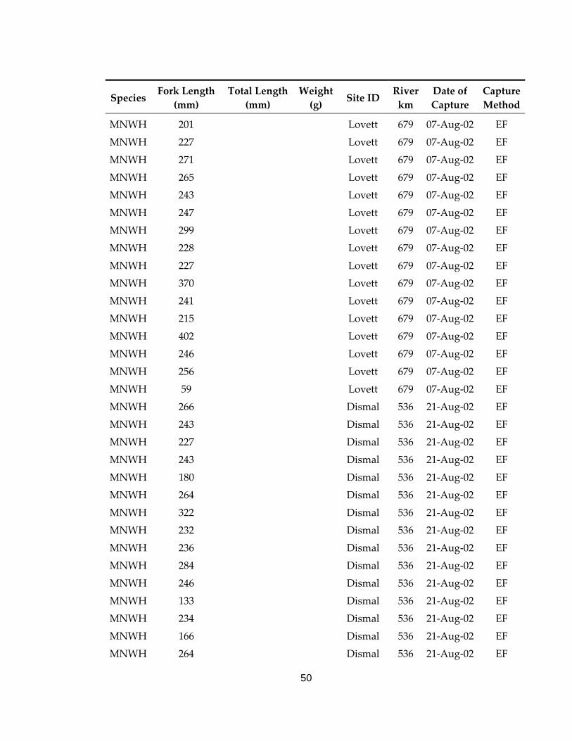
50
Species Fork Length
(mm) Total Length
(mm) Weight (g) Site ID
River km
Date of Capture
Capture Method
MNWH 201 Lovett 679 07‐Aug‐02 EF
MNWH 227 Lovett 679 07‐Aug‐02 EF
MNWH 271 Lovett 679 07‐Aug‐02 EF
MNWH 265 Lovett 679 07‐Aug‐02 EF
MNWH 243 Lovett 679 07‐Aug‐02 EF
MNWH 247 Lovett 679 07‐Aug‐02 EF
MNWH 299 Lovett 679 07‐Aug‐02 EF
MNWH 228 Lovett 679 07‐Aug‐02 EF
MNWH 227 Lovett 679 07‐Aug‐02 EF
MNWH 370 Lovett 679 07‐Aug‐02 EF
MNWH 241 Lovett 679 07‐Aug‐02 EF
MNWH 215 Lovett 679 07‐Aug‐02 EF
MNWH 402 Lovett 679 07‐Aug‐02 EF
MNWH 246 Lovett 679 07‐Aug‐02 EF
MNWH 256 Lovett 679 07‐Aug‐02 EF
MNWH 59 Lovett 679 07‐Aug‐02 EF
MNWH 266 Dismal 536 21‐Aug‐02 EF
MNWH 243 Dismal 536 21‐Aug‐02 EF
MNWH 227 Dismal 536 21‐Aug‐02 EF
MNWH 243 Dismal 536 21‐Aug‐02 EF
MNWH 180 Dismal 536 21‐Aug‐02 EF
MNWH 264 Dismal 536 21‐Aug‐02 EF
MNWH 322 Dismal 536 21‐Aug‐02 EF
MNWH 232 Dismal 536 21‐Aug‐02 EF
MNWH 236 Dismal 536 21‐Aug‐02 EF
MNWH 284 Dismal 536 21‐Aug‐02 EF
MNWH 246 Dismal 536 21‐Aug‐02 EF
MNWH 133 Dismal 536 21‐Aug‐02 EF
MNWH 234 Dismal 536 21‐Aug‐02 EF
MNWH 166 Dismal 536 21‐Aug‐02 EF
MNWH 264 Dismal 536 21‐Aug‐02 EF
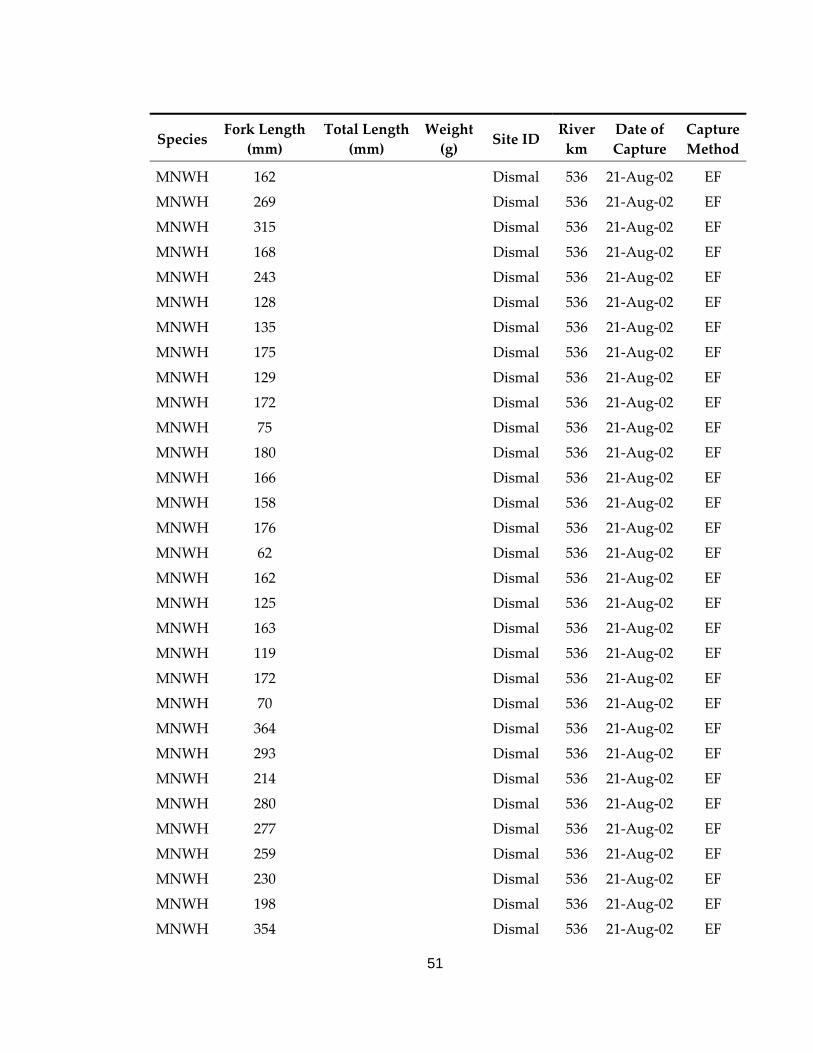
51
Species Fork Length
(mm) Total Length
(mm) Weight (g) Site ID
River km
Date of Capture
Capture Method
MNWH 162 Dismal 536 21‐Aug‐02 EF
MNWH 269 Dismal 536 21‐Aug‐02 EF
MNWH 315 Dismal 536 21‐Aug‐02 EF
MNWH 168 Dismal 536 21‐Aug‐02 EF
MNWH 243 Dismal 536 21‐Aug‐02 EF
MNWH 128 Dismal 536 21‐Aug‐02 EF
MNWH 135 Dismal 536 21‐Aug‐02 EF
MNWH 175 Dismal 536 21‐Aug‐02 EF
MNWH 129 Dismal 536 21‐Aug‐02 EF
MNWH 172 Dismal 536 21‐Aug‐02 EF
MNWH 75 Dismal 536 21‐Aug‐02 EF
MNWH 180 Dismal 536 21‐Aug‐02 EF
MNWH 166 Dismal 536 21‐Aug‐02 EF
MNWH 158 Dismal 536 21‐Aug‐02 EF
MNWH 176 Dismal 536 21‐Aug‐02 EF
MNWH 62 Dismal 536 21‐Aug‐02 EF
MNWH 162 Dismal 536 21‐Aug‐02 EF
MNWH 125 Dismal 536 21‐Aug‐02 EF
MNWH 163 Dismal 536 21‐Aug‐02 EF
MNWH 119 Dismal 536 21‐Aug‐02 EF
MNWH 172 Dismal 536 21‐Aug‐02 EF
MNWH 70 Dismal 536 21‐Aug‐02 EF
MNWH 364 Dismal 536 21‐Aug‐02 EF
MNWH 293 Dismal 536 21‐Aug‐02 EF
MNWH 214 Dismal 536 21‐Aug‐02 EF
MNWH 280 Dismal 536 21‐Aug‐02 EF
MNWH 277 Dismal 536 21‐Aug‐02 EF
MNWH 259 Dismal 536 21‐Aug‐02 EF
MNWH 230 Dismal 536 21‐Aug‐02 EF
MNWH 198 Dismal 536 21‐Aug‐02 EF
MNWH 354 Dismal 536 21‐Aug‐02 EF
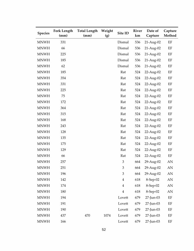
52
Species Fork Length
(mm) Total Length
(mm) Weight (g) Site ID
River km
Date of Capture
Capture Method
MNWH 331 Dismal 536 21‐Aug‐02 EF
MNWH 66 Dismal 536 21‐Aug‐02 EF
MNWH 225 Dismal 536 21‐Aug‐02 EF
MNWH 185 Dismal 536 21‐Aug‐02 EF
MNWH 62 Dismal 536 21‐Aug‐02 EF
MNWH 185 Rat 524 22‐Aug‐02 EF
MNWH 354 Rat 524 22‐Aug‐02 EF
MNWH 331 Rat 524 22‐Aug‐02 EF
MNWH 225 Rat 524 22‐Aug‐02 EF
MNWH 75 Rat 524 22‐Aug‐02 EF
MNWH 172 Rat 524 22‐Aug‐02 EF
MNWH 364 Rat 524 22‐Aug‐02 EF
MNWH 315 Rat 524 22‐Aug‐02 EF
MNWH 168 Rat 524 22‐Aug‐02 EF
MNWH 243 Rat 524 22‐Aug‐02 EF
MNWH 128 Rat 524 22‐Aug‐02 EF
MNWH 135 Rat 524 22‐Aug‐02 EF
MNWH 175 Rat 524 22‐Aug‐02 EF
MNWH 129 Rat 524 22‐Aug‐02 EF
MNWH 66 Rat 524 22‐Aug‐02 EF
MNWH 257 3 664 29‐Aug‐02 AN
MNWH 251 3 664 29‐Aug‐02 AN
MNWH 196 3 664 29‐Aug‐02 AN
MNWH 142 4 618 8‐Sep‐02 AN
MNWH 174 4 618 8‐Sep‐02 AN
MNWH 180 4 618 8‐Sep‐02 AN
MNWH 194 Lovett 679 27‐Jun‐03 EF
MNWH 191 Lovett 679 27‐Jun‐03 EF
MNWH 190 Lovett 679 27‐Jun‐03 EF
MNWH 437 470 1074 Lovett 679 27‐Jun‐03 EF
MNWH 166 Lovett 679 27‐Jun‐03 EF
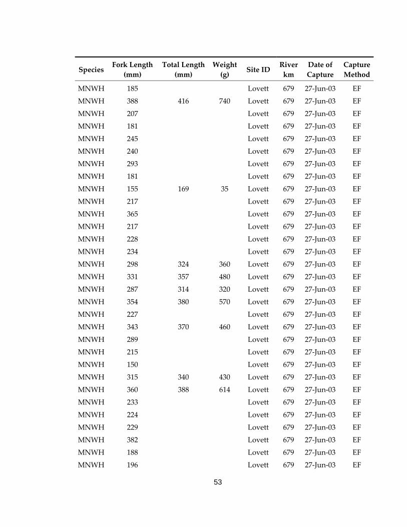
53
Species Fork Length
(mm) Total Length
(mm) Weight (g) Site ID
River km
Date of Capture
Capture Method
MNWH 185 Lovett 679 27‐Jun‐03 EF
MNWH 388 416 740 Lovett 679 27‐Jun‐03 EF
MNWH 207 Lovett 679 27‐Jun‐03 EF
MNWH 181 Lovett 679 27‐Jun‐03 EF
MNWH 245 Lovett 679 27‐Jun‐03 EF
MNWH 240 Lovett 679 27‐Jun‐03 EF
MNWH 293 Lovett 679 27‐Jun‐03 EF
MNWH 181 Lovett 679 27‐Jun‐03 EF
MNWH 155 169 35 Lovett 679 27‐Jun‐03 EF
MNWH 217 Lovett 679 27‐Jun‐03 EF
MNWH 365 Lovett 679 27‐Jun‐03 EF
MNWH 217 Lovett 679 27‐Jun‐03 EF
MNWH 228 Lovett 679 27‐Jun‐03 EF
MNWH 234 Lovett 679 27‐Jun‐03 EF
MNWH 298 324 360 Lovett 679 27‐Jun‐03 EF
MNWH 331 357 480 Lovett 679 27‐Jun‐03 EF
MNWH 287 314 320 Lovett 679 27‐Jun‐03 EF
MNWH 354 380 570 Lovett 679 27‐Jun‐03 EF
MNWH 227 Lovett 679 27‐Jun‐03 EF
MNWH 343 370 460 Lovett 679 27‐Jun‐03 EF
MNWH 289 Lovett 679 27‐Jun‐03 EF
MNWH 215 Lovett 679 27‐Jun‐03 EF
MNWH 150 Lovett 679 27‐Jun‐03 EF
MNWH 315 340 430 Lovett 679 27‐Jun‐03 EF
MNWH 360 388 614 Lovett 679 27‐Jun‐03 EF
MNWH 233 Lovett 679 27‐Jun‐03 EF
MNWH 224 Lovett 679 27‐Jun‐03 EF
MNWH 229 Lovett 679 27‐Jun‐03 EF
MNWH 382 Lovett 679 27‐Jun‐03 EF
MNWH 188 Lovett 679 27‐Jun‐03 EF
MNWH 196 Lovett 679 27‐Jun‐03 EF
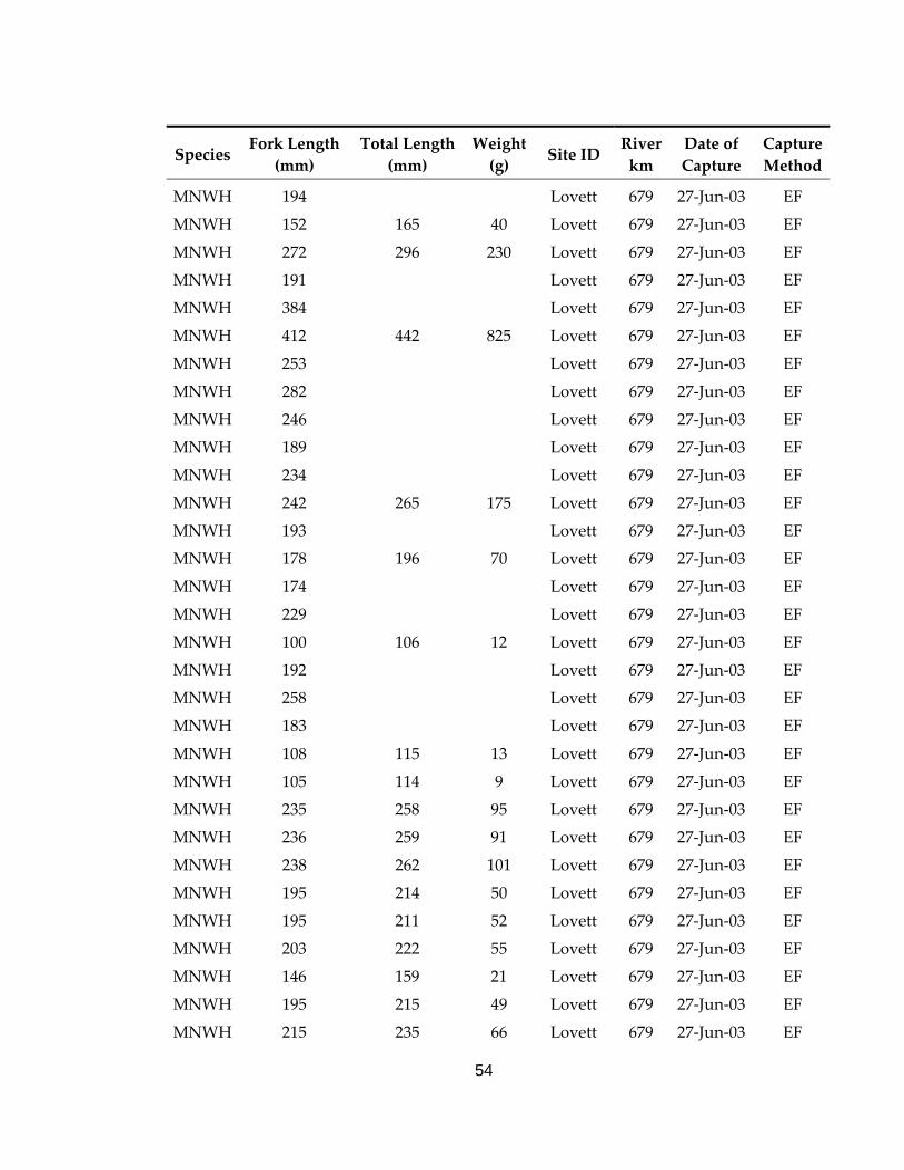
54
Species Fork Length
(mm) Total Length
(mm) Weight (g) Site ID
River km
Date of Capture
Capture Method
MNWH 194 Lovett 679 27‐Jun‐03 EF
MNWH 152 165 40 Lovett 679 27‐Jun‐03 EF
MNWH 272 296 230 Lovett 679 27‐Jun‐03 EF
MNWH 191 Lovett 679 27‐Jun‐03 EF
MNWH 384 Lovett 679 27‐Jun‐03 EF
MNWH 412 442 825 Lovett 679 27‐Jun‐03 EF
MNWH 253 Lovett 679 27‐Jun‐03 EF
MNWH 282 Lovett 679 27‐Jun‐03 EF
MNWH 246 Lovett 679 27‐Jun‐03 EF
MNWH 189 Lovett 679 27‐Jun‐03 EF
MNWH 234 Lovett 679 27‐Jun‐03 EF
MNWH 242 265 175 Lovett 679 27‐Jun‐03 EF
MNWH 193 Lovett 679 27‐Jun‐03 EF
MNWH 178 196 70 Lovett 679 27‐Jun‐03 EF
MNWH 174 Lovett 679 27‐Jun‐03 EF
MNWH 229 Lovett 679 27‐Jun‐03 EF
MNWH 100 106 12 Lovett 679 27‐Jun‐03 EF
MNWH 192 Lovett 679 27‐Jun‐03 EF
MNWH 258 Lovett 679 27‐Jun‐03 EF
MNWH 183 Lovett 679 27‐Jun‐03 EF
MNWH 108 115 13 Lovett 679 27‐Jun‐03 EF
MNWH 105 114 9 Lovett 679 27‐Jun‐03 EF
MNWH 235 258 95 Lovett 679 27‐Jun‐03 EF
MNWH 236 259 91 Lovett 679 27‐Jun‐03 EF
MNWH 238 262 101 Lovett 679 27‐Jun‐03 EF
MNWH 195 214 50 Lovett 679 27‐Jun‐03 EF
MNWH 195 211 52 Lovett 679 27‐Jun‐03 EF
MNWH 203 222 55 Lovett 679 27‐Jun‐03 EF
MNWH 146 159 21 Lovett 679 27‐Jun‐03 EF
MNWH 195 215 49 Lovett 679 27‐Jun‐03 EF
MNWH 215 235 66 Lovett 679 27‐Jun‐03 EF
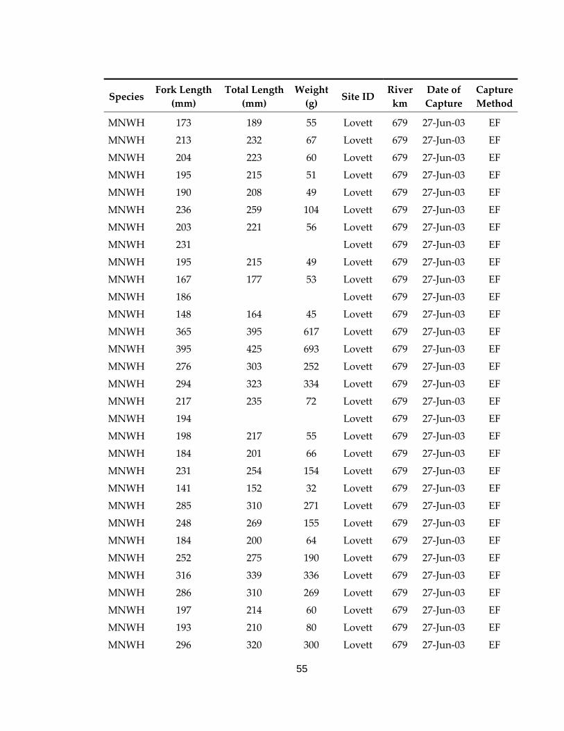
55
Species Fork Length
(mm) Total Length
(mm) Weight (g) Site ID
River km
Date of Capture
Capture Method
MNWH 173 189 55 Lovett 679 27‐Jun‐03 EF
MNWH 213 232 67 Lovett 679 27‐Jun‐03 EF
MNWH 204 223 60 Lovett 679 27‐Jun‐03 EF
MNWH 195 215 51 Lovett 679 27‐Jun‐03 EF
MNWH 190 208 49 Lovett 679 27‐Jun‐03 EF
MNWH 236 259 104 Lovett 679 27‐Jun‐03 EF
MNWH 203 221 56 Lovett 679 27‐Jun‐03 EF
MNWH 231 Lovett 679 27‐Jun‐03 EF
MNWH 195 215 49 Lovett 679 27‐Jun‐03 EF
MNWH 167 177 53 Lovett 679 27‐Jun‐03 EF
MNWH 186 Lovett 679 27‐Jun‐03 EF
MNWH 148 164 45 Lovett 679 27‐Jun‐03 EF
MNWH 365 395 617 Lovett 679 27‐Jun‐03 EF
MNWH 395 425 693 Lovett 679 27‐Jun‐03 EF
MNWH 276 303 252 Lovett 679 27‐Jun‐03 EF
MNWH 294 323 334 Lovett 679 27‐Jun‐03 EF
MNWH 217 235 72 Lovett 679 27‐Jun‐03 EF
MNWH 194 Lovett 679 27‐Jun‐03 EF
MNWH 198 217 55 Lovett 679 27‐Jun‐03 EF
MNWH 184 201 66 Lovett 679 27‐Jun‐03 EF
MNWH 231 254 154 Lovett 679 27‐Jun‐03 EF
MNWH 141 152 32 Lovett 679 27‐Jun‐03 EF
MNWH 285 310 271 Lovett 679 27‐Jun‐03 EF
MNWH 248 269 155 Lovett 679 27‐Jun‐03 EF
MNWH 184 200 64 Lovett 679 27‐Jun‐03 EF
MNWH 252 275 190 Lovett 679 27‐Jun‐03 EF
MNWH 316 339 336 Lovett 679 27‐Jun‐03 EF
MNWH 286 310 269 Lovett 679 27‐Jun‐03 EF
MNWH 197 214 60 Lovett 679 27‐Jun‐03 EF
MNWH 193 210 80 Lovett 679 27‐Jun‐03 EF
MNWH 296 320 300 Lovett 679 27‐Jun‐03 EF
56
Species Fork Length
(mm) Total Length
(mm) Weight (g) Site ID
River km
Date of Capture
Capture Method
MNWH 302 326 340 Lovett 679 27‐Jun‐03 EF
MNWH 188 205 80 Lovett 679 27‐Jun‐03 EF
MNWH 195 215 70 Lovett 679 27‐Jun‐03 EF
MNWH 106 114 10 Lovett 679 27‐Jun‐03 EF
MNWH 188 206 70 Lovett 679 27‐Jun‐03 EF
MNWH 140 154 30 Lovett 679 27‐Jun‐03 EF
MNWH 265 287 223 Lovett 679 27‐Jun‐03 EF
MNWH 164 179 47 Lovett 679 27‐Jun‐03 EF
MNWH 194 213 77 Lovett 679 27‐Jun‐03 EF
MNWH 195 213 84 Lovett 679 27‐Jun‐03 EF
MNWH 221 241 135 Lovett 679 27‐Jun‐03 EF
MNWH 196 216 76 Lovett 679 27‐Jun‐03 EF
MNWH 201 218 79 Lovett 679 27‐Jun‐03 EF
MNWH 188 206 70 Lovett 679 27‐Jun‐03 EF
MNWH 276 301 147 Lovett 679 27‐Jun‐03 EF
MNWH 213 232 69 Lovett 679 27‐Jun‐03 EF
MNWH 238 262 93 Lovett 679 27‐Jun‐03 EF
MNWH 213 233 81 Lovett 679 27‐Jun‐03 EF
MNWH 180 198 37 Lovett 679 27‐Jun‐03 EF
MNWH 210 228 62 Lovett 679 27‐Jun‐03 EF
MNWH 270 297 174 Lovett 679 27‐Jun‐03 EF
MNWH 181 197 60 Lovett 679 27‐Jun‐03 EF
MNWH 253 273 111 Lovett 679 27‐Jun‐03 EF
MNWH 205 Lovett 679 27‐Jun‐03 EF
MNWH 281 308 159 Lovett 679 27‐Jun‐03 EF
MNWH 370 403 393 Lovett 679 27‐Jun‐03 EF
MNWH 336 369 283 Lovett 679 27‐Jun‐03 EF
MNWH 250 270 115 Lovett 679 27‐Jun‐03 EF
MNWH 435 468 657 Lovett 679 27‐Jun‐03 EF
MNWH 255 278 107 Lovett 679 27‐Jun‐03 EF
MNWH 382 408 425 Lovett 679 27‐Jun‐03 EF
57
Species Fork Length
(mm) Total Length
(mm) Weight (g) Site ID
River km
Date of Capture
Capture Method
MNWH 193 209 45 Lovett 679 27‐Jun‐03 EF
MNWH 230 251 130 Lovett 679 27‐Jun‐03 EF
MNWH 184 Lovett 679 27‐Jun‐03 EF
MNWH 360 387 530 Lovett 679 27‐Jun‐03 EF
MNWH 350 381 640 Lovett 679 27‐Jun‐03 EF
MNWH 381 411 740 Lovett 679 27‐Jun‐03 EF
MNWH 435 470 1160 Lovett 679 27‐Jun‐03 EF
MNWH 195 Lovett 679 27‐Jun‐03 EF
MNWH 241 262 160 Lovett 679 27‐Jun‐03 EF
MNWH 212 Lovett 679 27‐Jun‐03 EF
MNWH 205 Lovett 679 27‐Jun‐03 EF
MNWH 202 Lovett 679 27‐Jun‐03 EF
MNWH 202 Lovett 679 27‐Jun‐03 EF
MNWH 267 Lovett 679 27‐Jun‐03 EF
MNWH 258 Lovett 679 27‐Jun‐03 EF
MNWH 326 352 460 Lovett 679 27‐Jun‐03 EF
MNWH 345 376 480 Lovett 679 27‐Jun‐03 EF
MNWH 184 Lovett 679 27‐Jun‐03 EF
MNWH 251 Lovett 679 27‐Jun‐03 EF
MNWH 190 Lovett 679 27‐Jun‐03 EF
MNWH 190 Lovett 679 27‐Jun‐03 EF
MNWH 245 Lovett 679 27‐Jun‐03 EF
MNWH 222 Lovett 679 27‐Jun‐03 EF
MNWH 187 Lovett 679 27‐Jun‐03 EF
MNWH 250 Lovett 679 27‐Jun‐03 EF
MNWH 321 348 400 Lovett 679 27‐Jun‐03 EF
MNWH 210 Lovett 679 27‐Jun‐03 EF
MNWH 262 Lovett 679 27‐Jun‐03 EF
MNWH 192 Lovett 679 27‐Jun‐03 EF
MNWH 189 Lovett 679 27‐Jun‐03 EF
MNWH 247 Lovett 679 27‐Jun‐03 EF
58
Species Fork Length
(mm) Total Length
(mm) Weight (g) Site ID
River km
Date of Capture
Capture Method
MNWH 226 248 130 Lovett 679 27‐Jun‐03 EF
MNWH 200 Lovett 679 27‐Jun‐03 EF
MNWH 194 Lovett 679 27‐Jun‐03 EF
MNWH 242 Lovett 679 27‐Jun‐03 EF
MNWH 194 Lovett 679 27‐Jun‐03 EF
MNWH 194 Lovett 679 27‐Jun‐03 EF
MNWH 260 285 212 Lovett 679 27‐Jun‐03 EF
MNWH 249 Lovett 679 27‐Jun‐03 EF
MNWH 249 Lovett 679 27‐Jun‐03 EF
MNWH 232 Lovett 679 27‐Jun‐03 EF
MNWH 214 Lovett 679 27‐Jun‐03 EF
MNWH 265 Lovett 679 27‐Jun‐03 EF
MNWH 211 Lovett 679 27‐Jun‐03 EF
MNWH 196 Lovett 679 27‐Jun‐03 EF
MNWH 255 Lovett 679 27‐Jun‐03 EF
MNWH 225 245 140 Lovett 679 27‐Jun‐03 EF
MNWH 105 110 11 Lovett 679 27‐Jun‐03 EF
MNWH 195 Lovett 679 27‐Jun‐03 EF
MNWH 213 Lovett 679 27‐Jun‐03 EF
MNWH 183 Lovett 679 27‐Jun‐03 EF
MNWH 160 175 60 Lovett 679 27‐Jun‐03 EF
MNWH 204 Lovett 679 27‐Jun‐03 EF
MNWH 218 237 117 Lovett 679 27‐Jun‐03 EF
MNWH 284 Lovett 679 27‐Jun‐03 EF
MNWH 192 Lovett 679 27‐Jun‐03 EF
MNWH 198 Lovett 679 27‐Jun‐03 EF
MNWH 205 Lovett 679 27‐Jun‐03 EF
MNWH 250 Lovett 679 27‐Jun‐03 EF
MNWH 259 282 199 Lovett 679 27‐Jun‐03 EF
MNWH 294 314 291 Lovett 679 27‐Jun‐03 EF
MNWH 200 Lovett 679 27‐Jun‐03 EF
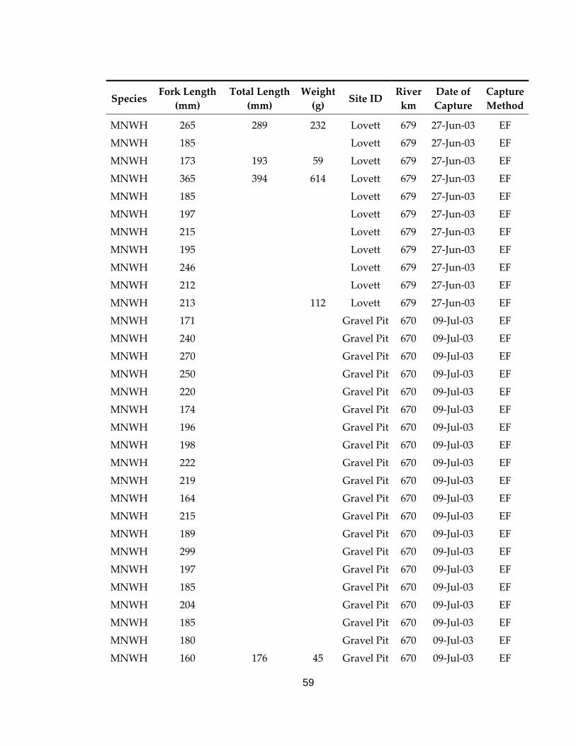
59
Species Fork Length
(mm) Total Length
(mm) Weight (g) Site ID
River km
Date of Capture
Capture Method
MNWH 265 289 232 Lovett 679 27‐Jun‐03 EF
MNWH 185 Lovett 679 27‐Jun‐03 EF
MNWH 173 193 59 Lovett 679 27‐Jun‐03 EF
MNWH 365 394 614 Lovett 679 27‐Jun‐03 EF
MNWH 185 Lovett 679 27‐Jun‐03 EF
MNWH 197 Lovett 679 27‐Jun‐03 EF
MNWH 215 Lovett 679 27‐Jun‐03 EF
MNWH 195 Lovett 679 27‐Jun‐03 EF
MNWH 246 Lovett 679 27‐Jun‐03 EF
MNWH 212 Lovett 679 27‐Jun‐03 EF
MNWH 213 112 Lovett 679 27‐Jun‐03 EF
MNWH 171 Gravel Pit 670 09‐Jul‐03 EF
MNWH 240 Gravel Pit 670 09‐Jul‐03 EF
MNWH 270 Gravel Pit 670 09‐Jul‐03 EF
MNWH 250 Gravel Pit 670 09‐Jul‐03 EF
MNWH 220 Gravel Pit 670 09‐Jul‐03 EF
MNWH 174 Gravel Pit 670 09‐Jul‐03 EF
MNWH 196 Gravel Pit 670 09‐Jul‐03 EF
MNWH 198 Gravel Pit 670 09‐Jul‐03 EF
MNWH 222 Gravel Pit 670 09‐Jul‐03 EF
MNWH 219 Gravel Pit 670 09‐Jul‐03 EF
MNWH 164 Gravel Pit 670 09‐Jul‐03 EF
MNWH 215 Gravel Pit 670 09‐Jul‐03 EF
MNWH 189 Gravel Pit 670 09‐Jul‐03 EF
MNWH 299 Gravel Pit 670 09‐Jul‐03 EF
MNWH 197 Gravel Pit 670 09‐Jul‐03 EF
MNWH 185 Gravel Pit 670 09‐Jul‐03 EF
MNWH 204 Gravel Pit 670 09‐Jul‐03 EF
MNWH 185 Gravel Pit 670 09‐Jul‐03 EF
MNWH 180 Gravel Pit 670 09‐Jul‐03 EF
MNWH 160 176 45 Gravel Pit 670 09‐Jul‐03 EF
60
Species Fork Length
(mm) Total Length
(mm) Weight (g) Site ID
River km
Date of Capture
Capture Method
MNWH 147 Gravel Pit 670 09‐Jul‐03 EF
MNWH 169 Gravel Pit 670 09‐Jul‐03 EF
MNWH 185 Gravel Pit 670 09‐Jul‐03 EF
MNWH 188 Gravel Pit 670 09‐Jul‐03 EF
MNWH 166 Gravel Pit 670 09‐Jul‐03 EF
MNWH 169 Gravel Pit 670 09‐Jul‐03 EF
MNWH 162 Gravel Pit 670 09‐Jul‐03 EF
MNWH 205 Gravel Pit 670 09‐Jul‐03 EF
MNWH 237 Gravel Pit 670 09‐Jul‐03 EF
MNWH 216 Gravel Pit 670 09‐Jul‐03 EF
MNWH 193 Gravel Pit 670 09‐Jul‐03 EF
MNWH 220 Gravel Pit 670 09‐Jul‐03 EF
MNWH 202 Gravel Pit 670 09‐Jul‐03 EF
MNWH 238 Gravel Pit 670 09‐Jul‐03 EF
MNWH 310 Gravel Pit 670 09‐Jul‐03 EF
MNWH 230 Gravel Pit 670 09‐Jul‐03 EF
MNWH 239 Gravel Pit 670 09‐Jul‐03 EF
MNWH 240 Gravel Pit 670 09‐Jul‐03 EF
MNWH 242 Gravel Pit 670 09‐Jul‐03 EF
MNWH 161 175 49 Gravel Pit 670 09‐Jul‐03 EF
MNWH 267 295 241 Gravel Pit 670 09‐Jul‐03 EF
MNWH 196 Gravel Pit 670 09‐Jul‐03 EF
MNWH 273 297 223 Gravel Pit 670 09‐Jul‐03 EF
MNWH 245 Gravel Pit 670 09‐Jul‐03 EF
MNWH 244 Gravel Pit 670 09‐Jul‐03 EF
MNWH 162 Gravel Pit 670 09‐Jul‐03 EF
MNWH 190 Gravel Pit 670 09‐Jul‐03 EF
MNWH 205 Gravel Pit 670 09‐Jul‐03 EF
MNWH 195 Gravel Pit 670 09‐Jul‐03 EF
MNWH 160 Gravel Pit 670 09‐Jul‐03 EF
MNWH 186 Gravel Pit 670 09‐Jul‐03 EF
61
Species Fork Length
(mm) Total Length
(mm) Weight (g) Site ID
River km
Date of Capture
Capture Method
MNWH 150 Gravel Pit 670 09‐Jul‐03 EF
MNWH 160 Gravel Pit 670 09‐Jul‐03 EF
MNWH 120 129 135 Gravel Pit 670 09‐Jul‐03 EF
MNWH 160 Gravel Pit 670 09‐Jul‐03 EF
MNWH 325 350 361 Gravel Pit 670 09‐Jul‐03 EF
MNWH 110 Gravel Pit 670 09‐Jul‐03 EF
MNWH 119 129 110 Gravel Pit 670 09‐Jul‐03 EF
MNWH 120 Gravel Pit 670 09‐Jul‐03 EF
MNWH 210 Gravel Pit 670 09‐Jul‐03 EF
MNWH 255 Gravel Pit 670 09‐Jul‐03 EF
MNWH 233 Gravel Pit 670 09‐Jul‐03 EF
MNWH 235 Gravel Pit 670 09‐Jul‐03 EF
MNWH 226 Gravel Pit 670 09‐Jul‐03 EF
MNWH 238 Gravel Pit 670 09‐Jul‐03 EF
MNWH 256 Gravel Pit 670 09‐Jul‐03 EF
MNWH 250 Gravel Pit 670 09‐Jul‐03 EF
MNWH 227 Gravel Pit 670 09‐Jul‐03 EF
MNWH 282 Gravel Pit 670 09‐Jul‐03 EF
MNWH 187 Gravel Pit 670 09‐Jul‐03 EF
MNWH 187 Gravel Pit 670 09‐Jul‐03 EF
MNWH 244 Gravel Pit 670 09‐Jul‐03 EF
MNWH 190 Gravel Pit 670 09‐Jul‐03 EF
MNWH 243 Gravel Pit 670 09‐Jul‐03 EF
MNWH 239 Gravel Pit 670 09‐Jul‐03 EF
MNWH 227 Gravel Pit 670 09‐Jul‐03 EF
MNWH 164 Gravel Pit 670 09‐Jul‐03 EF
MNWH 163 Gravel Pit 670 09‐Jul‐03 EF
MNWH 240 Gravel Pit 670 09‐Jul‐03 EF
MNWH 180 Gravel Pit 670 09‐Jul‐03 EF
MNWH 182 Gravel Pit 670 09‐Jul‐03 EF
MNWH 195 Gravel Pit 670 09‐Jul‐03 EF

62
Species Fork Length
(mm) Total Length
(mm) Weight (g) Site ID
River km
Date of Capture
Capture Method
MNWH 228 Gravel Pit 670 09‐Jul‐03 EF
MNWH 194 Gravel Pit 670 09‐Jul‐03 EF
MNWH 235 Gravel Pit 670 09‐Jul‐03 EF
MNWH 265 Gravel Pit 670 09‐Jul‐03 EF
MNWH 235 Gravel Pit 670 09‐Jul‐03 EF
MNWH 190 Gravel Pit 670 09‐Jul‐03 EF
MNWH 237 Gravel Pit 670 09‐Jul‐03 EF
MNWH 224 Gravel Pit 670 09‐Jul‐03 EF
MNWH 213 Gravel Pit 670 09‐Jul‐03 EF
MNWH 246 Gravel Pit 670 09‐Jul‐03 EF
MNWH 157 Gravel Pit 670 09‐Jul‐03 EF
MNWH 211 Gravel Pit 670 09‐Jul‐03 EF
MNWH 185 Gravel Pit 670 09‐Jul‐03 EF
MNWH 178 Gravel Pit 670 09‐Jul‐03 EF
MNWH 172 Gravel Pit 670 09‐Jul‐03 EF
MNWH 213 Gravel Pit 670 09‐Jul‐03 EF
MNWH 194 Gravel Pit 670 09‐Jul‐03 EF
MNWH 203 Gravel Pit 670 09‐Jul‐03 EF
MNWH 225 Gravel Pit 670 09‐Jul‐03 EF
MNWH 250 Gravel Pit 670 09‐Jul‐03 EF
MNWH 228 Gravel Pit 670 09‐Jul‐03 EF
MNWH 197 Gravel Pit 670 09‐Jul‐03 EF
MNWH 265 Gravel Pit 670 09‐Jul‐03 EF
MNWH 175 Gravel Pit 670 09‐Jul‐03 EF
MNWH 195 Gravel Pit 670 09‐Jul‐03 EF
MNWH 186 Gravel Pit 670 09‐Jul‐03 EF
MNWH 206 Gravel Pit 670 09‐Jul‐03 EF
MNWH 196 Gravel Pit 670 09‐Jul‐03 EF
MNWH 209 Gravel Pit 670 09‐Jul‐03 EF
MNWH 155 Gravel Pit 670 09‐Jul‐03 EF
MNWH 245 Gravel Pit 670 09‐Jul‐03 EF
63
Species Fork Length
(mm) Total Length
(mm) Weight (g) Site ID
River km
Date of Capture
Capture Method
MNWH 196 Gravel Pit 670 09‐Jul‐03 EF
MNWH 160 Gravel Pit 670 09‐Jul‐03 EF
MNWH 201 Gravel Pit 670 09‐Jul‐03 EF
MNWH 226 Gravel Pit 670 09‐Jul‐03 EF
MNWH 255 Gravel Pit 670 09‐Jul‐03 EF
MNWH 165 Gravel Pit 670 09‐Jul‐03 EF
MNWH 154 Gravel Pit 670 09‐Jul‐03 EF
MNWH 194 Gravel Pit 670 09‐Jul‐03 EF
MNWH 193 Gravel Pit 670 09‐Jul‐03 EF
MNWH 240 Gravel Pit 670 09‐Jul‐03 EF
MNWH 160 Gravel Pit 670 09‐Jul‐03 EF
MNWH 252 Gravel Pit 670 09‐Jul‐03 EF
MNWH 125 135 19 Gravel Pit 670 09‐Jul‐03 EF
MNWH 114 124 15 Gravel Pit 670 09‐Jul‐03 EF
MNWH 339 360 456 Gravel Pit 670 09‐Jul‐03 EF
MNWH 193 Gravel Pit 670 09‐Jul‐03 EF
MNWH 234 Gravel Pit 670 09‐Jul‐03 EF
MNWH 190 Gravel Pit 670 09‐Jul‐03 EF
MNWH 224 Gravel Pit 670 09‐Jul‐03 EF
MNWH 259 Gravel Pit 670 09‐Jul‐03 EF
MNWH 263 Gravel Pit 670 09‐Jul‐03 EF
MNWH 200 Gravel Pit 670 09‐Jul‐03 EF
MNWH 190 Gravel Pit 670 09‐Jul‐03 EF
MNWH 223 Gravel Pit 670 09‐Jul‐03 EF
MNWH 110 Gravel Pit 670 09‐Jul‐03 EF
MNWH 186 Gravel Pit 670 09‐Jul‐03 EF
MNWH 285 Gravel Pit 670 09‐Jul‐03 EF
MNWH 245 Gravel Pit 670 09‐Jul‐03 EF
MNWH 211 Gravel Pit 670 09‐Jul‐03 EF
MNWH 165 Gravel Pit 670 09‐Jul‐03 EF
MNWH 193 Gravel Pit 670 09‐Jul‐03 EF

64
Species Fork Length
(mm) Total Length
(mm) Weight (g) Site ID
River km
Date of Capture
Capture Method
MNWH 197 Gravel Pit 670 09‐Jul‐03 EF
MNWH 185 Gravel Pit 670 09‐Jul‐03 EF
MNWH 211 Gravel Pit 670 09‐Jul‐03 EF
MNWH 193 Gravel Pit 670 09‐Jul‐03 EF
MNWH 203 Gravel Pit 670 09‐Jul‐03 EF
MNWH 203 Gravel Pit 670 09‐Jul‐03 EF
MNWH 176 Gravel Pit 670 09‐Jul‐03 EF
MNWH 263 Gravel Pit 670 09‐Jul‐03 EF
MNWH 219 Gravel Pit 670 09‐Jul‐03 EF
MNWH 194 Gravel Pit 670 09‐Jul‐03 EF
MNWH 198 Gravel Pit 670 09‐Jul‐03 EF
MNWH 201 Gravel Pit 670 09‐Jul‐03 EF
MNWH 174 Gravel Pit 670 09‐Jul‐03 EF
MNWH 245 Gravel Pit 670 09‐Jul‐03 EF
MNWH 250 Gravel Pit 670 09‐Jul‐03 EF
MNWH 204 Gravel Pit 670 09‐Jul‐03 EF
MNWH 176 Gravel Pit 670 09‐Jul‐03 EF
MNWH 215 Gravel Pit 670 09‐Jul‐03 EF
MNWH 251 Gravel Pit 670 09‐Jul‐03 EF
MNWH 242 Gravel Pit 670 09‐Jul‐03 EF
MNWH 280 Gravel Pit 670 09‐Jul‐03 EF
MNWH 162 Gravel Pit 670 09‐Jul‐03 EF
MNWH 215 Gravel Pit 670 09‐Jul‐03 EF
MNWH 273 Gravel Pit 670 09‐Jul‐03 EF
MNWH 274 Gravel Pit 670 09‐Jul‐03 EF
MNWH 212 Gravel Pit 670 09‐Jul‐03 EF
MNWH 187 Gravel Pit 670 09‐Jul‐03 EF
MNWH 187 Gravel Pit 670 09‐Jul‐03 EF
MNWH 191 Gravel Pit 670 09‐Jul‐03 EF
MNWH 218 Gravel Pit 670 09‐Jul‐03 EF
MNWH 195 Gravel Pit 670 09‐Jul‐03 EF
65
Species Fork Length
(mm) Total Length
(mm) Weight (g) Site ID
River km
Date of Capture
Capture Method
MNWH 233 Gravel Pit 670 09‐Jul‐03 EF
MNWH 179 Gravel Pit 670 09‐Jul‐03 EF
MNWH 271 Gravel Pit 670 09‐Jul‐03 EF
MNWH 230 Gravel Pit 670 09‐Jul‐03 EF
MNWH 190 Gravel Pit 670 09‐Jul‐03 EF
MNWH 345 Gravel Pit 670 09‐Jul‐03 EF
MNWH 110 Gravel Pit 670 09‐Jul‐03 EF
MNWH 280 Gravel Pit 670 09‐Jul‐03 EF
MNWH 175 Gravel Pit 670 09‐Jul‐03 EF
MNWH 172 Gravel Pit 670 09‐Jul‐03 EF
MNWH 272 Gravel Pit 670 09‐Jul‐03 EF
MNWH 171 Gravel Pit 670 09‐Jul‐03 EF
MNWH 189 Gravel Pit 670 09‐Jul‐03 EF
MNWH 175 Gravel Pit 670 09‐Jul‐03 EF
MNWH 194 Gravel Pit 670 09‐Jul‐03 EF
MNWH 188 Gravel Pit 670 09‐Jul‐03 EF
MNWH 202 Gravel Pit 670 09‐Jul‐03 EF
MNWH 183 Gravel Pit 670 09‐Jul‐03 EF
MNWH 156 Gravel Pit 670 09‐Jul‐03 EF
MNWH 118 Gravel Pit 670 09‐Jul‐03 EF
MNWH 210 Gravel Pit 670 09‐Jul‐03 EF
MNWH 211 Gravel Pit 670 09‐Jul‐03 EF
MNWH 199 Gravel Pit 670 09‐Jul‐03 EF
MNWH 220 Gravel Pit 670 09‐Jul‐03 EF
MNWH 198 Gravel Pit 670 09‐Jul‐03 EF
MNWH 191 Gravel Pit 670 09‐Jul‐03 EF
MNWH 183 Gravel Pit 670 09‐Jul‐03 EF
MNWH 112 Gravel Pit 670 09‐Jul‐03 EF
MNWH 227 Gravel Pit 670 09‐Jul‐03 EF
MNWH 192 Gravel Pit 670 09‐Jul‐03 EF
MNWH 171 Gravel Pit 670 09‐Jul‐03 EF
66
Species Fork Length
(mm) Total Length
(mm) Weight (g) Site ID
River km
Date of Capture
Capture Method
MNWH 184 Gravel Pit 670 09‐Jul‐03 EF
MNWH 178 Gravel Pit 670 09‐Jul‐03 EF
MNWH 216 Gravel Pit 670 09‐Jul‐03 EF MNWH 223 Gravel Pit 670 09‐Jul‐03 EF MNWH 209 Gravel Pit 670 09‐Jul‐03 EF MNWH 185 Gravel Pit 670 09‐Jul‐03 EF MNWH 186 Gravel Pit 670 09‐Jul‐03 EF MNWH 208 Gravel Pit 670 09‐Jul‐03 EF MNWH 156 Gravel Pit 670 09‐Jul‐03 EF MNWH 183 Gravel Pit 670 09‐Jul‐03 EF MNWH 185 Gravel Pit 670 09‐Jul‐03 EF MNWH 185 Gravel Pit 670 09‐Jul‐03 EF MNWH 242 Gravel Pit 670 09‐Jul‐03 EF MNWH 219 Gravel Pit 670 09‐Jul‐03 EF MNWH 184 Gravel Pit 670 09‐Jul‐03 EF MNWH 196 Gravel Pit 670 09‐Jul‐03 EF MNWH 205 Gravel Pit 670 09‐Jul‐03 EF MNWH 148 Gravel Pit 670 09‐Jul‐03 EF MNWH 201 Gravel Pit 670 09‐Jul‐03 EF MNWH 229 Gravel Pit 670 09‐Jul‐03 EF MNWH 173 Gravel Pit 670 09‐Jul‐03 EF MNWH 195 Gravel Pit 670 09‐Jul‐03 EF MNWH 162 Gravel Pit 670 09‐Jul‐03 EF MNWH 208 Gravel Pit 670 09‐Jul‐03 EF MNWH 188 Gravel Pit 670 09‐Jul‐03 EF MNWH 198 Gravel Pit 670 09‐Jul‐03 EF MNWH 216 Gravel Pit 670 09‐Jul‐03 EF MNWH 303 Gravel Pit 670 09‐Jul‐03 EF MNWH 302 330 1030 Gravel Pit 670 09‐Jul‐03 EF MNWH 238 Gravel Pit 670 09‐Jul‐03 EF MNWH 215 Gravel Pit 670 09‐Jul‐03 EF
67
Species Fork Length
(mm) Total Length
(mm) Weight (g) Site ID
River km
Date of Capture
Capture Method
MNWH 199 Gravel Pit 670 09‐Jul‐03 EF MNWH 183 Gravel Pit 670 09‐Jul‐03 EF MNWH 193 Gravel Pit 670 09‐Jul‐03 EF MNWH 192 Gravel Pit 670 09‐Jul‐03 EF MNWH 121 125 Gravel Pit 670 09‐Jul‐03 EF MNWH 165 Gravel Pit 670 09‐Jul‐03 EF MNWH 271 Paddy 512 15‐Jul‐03 EF MNWH 247 Paddy 512 15‐Jul‐03 EF MNWH 218 Paddy 512 15‐Jul‐03 EF MNWH 115 Paddy 512 15‐Jul‐03 EF MNWH 184 Paddy 512 15‐Jul‐03 EF MNWH 358 540 Paddy 512 15‐Jul‐03 EF MNWH 275 Dismal 536 16‐Jul‐03 EF MNWH 285 Dismal 536 16‐Jul‐03 EF MNWH 282 Dismal 536 16‐Jul‐03 EF MNWH 294 Dismal 536 16‐Jul‐03 EF MNWH 292 Dismal 536 16‐Jul‐03 EF MNWH 132 20 Dismal 536 16‐Jul‐03 EF MNWH 114 Dismal 536 16‐Jul‐03 EF MNWH 331 Dismal 536 16‐Jul‐03 EF MNWH 269 Dismal 536 16‐Jul‐03 EF MNWH 113 Dismal 536 16‐Jul‐03 EF MNWH 295 Dismal 536 16‐Jul‐03 EF MNWH 252 Dismal 536 16‐Jul‐03 EF MNWH 360 Dismal 536 16‐Jul‐03 EF MNWH 247 Dismal 536 16‐Jul‐03 EF MNWH 263 Dismal 536 16‐Jul‐03 EF MNWH 118 Dismal 536 16‐Jul‐03 EF MNWH 290 312 Dismal 536 16‐Jul‐03 EF MNWH 317 369 Dismal 536 16‐Jul‐03 EF MNWH 276 292 Dismal 536 16‐Jul‐03 EF
68
Species Fork Length
(mm) Total Length
(mm) Weight (g) Site ID
River km
Date of Capture
Capture Method
MNWH 245 Dismal 536 16‐Jul‐03 EF MNWH 258 Rat 524 17‐Jul‐03 EF MNWH 115 Rat 524 17‐Jul‐03 EF MNWH 134 23 Rat 524 17‐Jul‐03 EF MNWH 125 Rat 524 17‐Jul‐03 EF MNWH 115 Rat 524 17‐Jul‐03 EF MNWH 124 Rat 524 17‐Jul‐03 EF MNWH 126 Rat 524 17‐Jul‐03 EF MNWH 272 Rat 524 17‐Jul‐03 EF MNWH 242 Rat 524 17‐Jul‐03 EF MNWH 113 Rat 524 17‐Jul‐03 EF MNWH 247 Rat 524 17‐Jul‐03 EF MNWH 363 Rat 524 17‐Jul‐03 EF MNWH 220 Rat 524 17‐Jul‐03 EF MNWH 255 Rat 524 17‐Jul‐03 EF MNWH 299 7 618 14‐Aug‐03 AN MNWH 285 7 618 14‐Aug‐03 AN MNWH 217 7 618 14‐Aug‐03 AN MNWH 281 7 618 14‐Aug‐03 AN MNWH 260 7 618 14‐Aug‐03 AN MNWH 237 7 618 14‐Aug‐03 AN MNWH 239 7 618 14‐Aug‐03 AN MNWH 267 7 618 14‐Aug‐03 AN MNWH 250 7 618 14‐Aug‐03 AN MNWH 347 7 618 14‐Aug‐03 AN MNWH 258 7 618 14‐Aug‐03 AN MNWH 209 7 618 14‐Aug‐03 AN MNWH 243 9 618 03‐Sep‐03 AN MNWH 205 9 618 03‐Sep‐03 AN MNWH 235 9 618 03‐Sep‐03 AN MNWH 275 9 618 03‐Sep‐03 AN
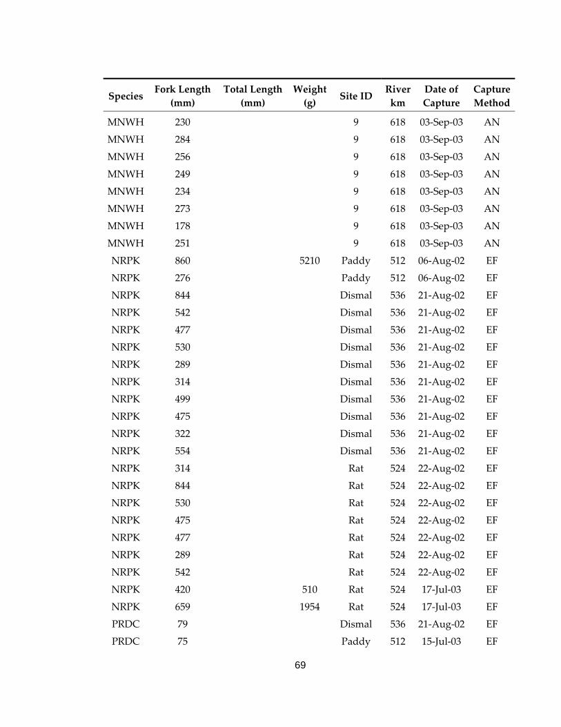
69
Species Fork Length
(mm) Total Length
(mm) Weight (g) Site ID
River km
Date of Capture
Capture Method
MNWH 230 9 618 03‐Sep‐03 AN MNWH 284 9 618 03‐Sep‐03 AN MNWH 256 9 618 03‐Sep‐03 AN MNWH 249 9 618 03‐Sep‐03 AN MNWH 234 9 618 03‐Sep‐03 AN MNWH 273 9 618 03‐Sep‐03 AN MNWH 178 9 618 03‐Sep‐03 AN MNWH 251 9 618 03‐Sep‐03 AN NRPK 860 5210 Paddy 512 06‐Aug‐02 EF NRPK 276 Paddy 512 06‐Aug‐02 EF NRPK 844 Dismal 536 21‐Aug‐02 EF NRPK 542 Dismal 536 21‐Aug‐02 EF NRPK 477 Dismal 536 21‐Aug‐02 EF NRPK 530 Dismal 536 21‐Aug‐02 EF NRPK 289 Dismal 536 21‐Aug‐02 EF NRPK 314 Dismal 536 21‐Aug‐02 EF NRPK 499 Dismal 536 21‐Aug‐02 EF NRPK 475 Dismal 536 21‐Aug‐02 EF NRPK 322 Dismal 536 21‐Aug‐02 EF NRPK 554 Dismal 536 21‐Aug‐02 EF NRPK 314 Rat 524 22‐Aug‐02 EF NRPK 844 Rat 524 22‐Aug‐02 EF NRPK 530 Rat 524 22‐Aug‐02 EF NRPK 475 Rat 524 22‐Aug‐02 EF NRPK 477 Rat 524 22‐Aug‐02 EF NRPK 289 Rat 524 22‐Aug‐02 EF NRPK 542 Rat 524 22‐Aug‐02 EF NRPK 420 510 Rat 524 17‐Jul‐03 EF NRPK 659 1954 Rat 524 17‐Jul‐03 EF PRDC 79 Dismal 536 21‐Aug‐02 EF PRDC 75 Paddy 512 15‐Jul‐03 EF
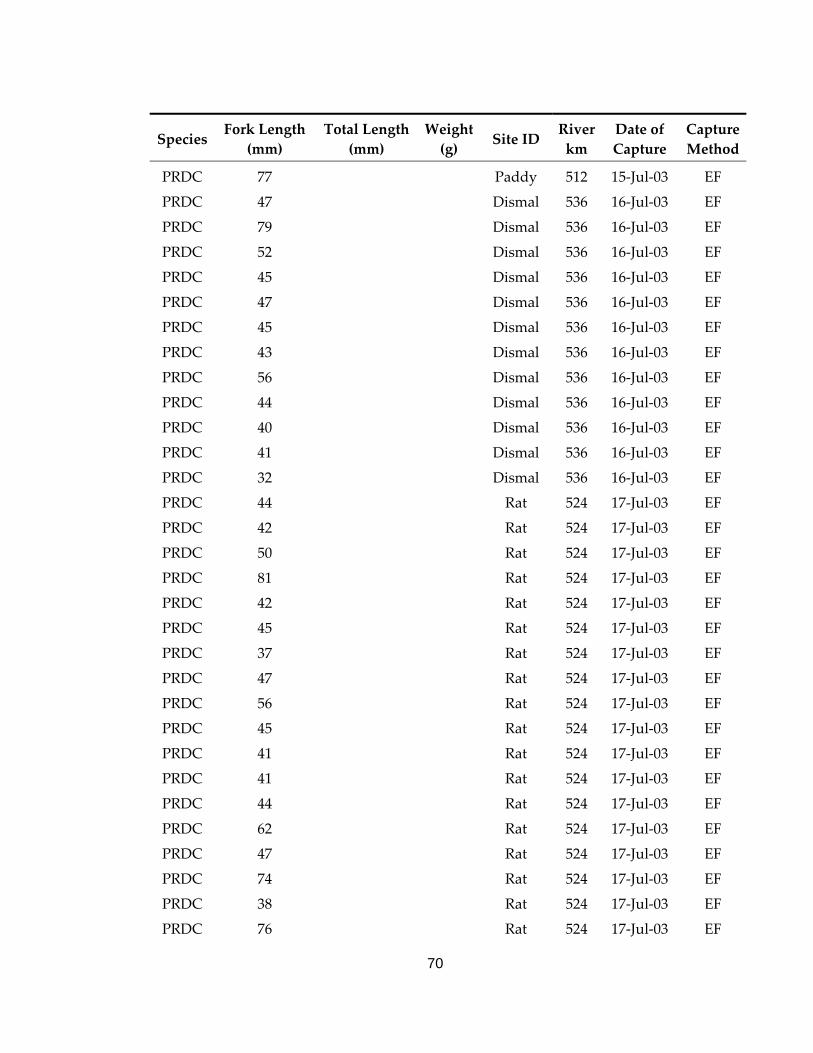
70
Species Fork Length
(mm) Total Length
(mm) Weight (g) Site ID
River km
Date of Capture
Capture Method
PRDC 77 Paddy 512 15‐Jul‐03 EF PRDC 47 Dismal 536 16‐Jul‐03 EF PRDC 79 Dismal 536 16‐Jul‐03 EF PRDC 52 Dismal 536 16‐Jul‐03 EF PRDC 45 Dismal 536 16‐Jul‐03 EF PRDC 47 Dismal 536 16‐Jul‐03 EF PRDC 45 Dismal 536 16‐Jul‐03 EF PRDC 43 Dismal 536 16‐Jul‐03 EF PRDC 56 Dismal 536 16‐Jul‐03 EF PRDC 44 Dismal 536 16‐Jul‐03 EF PRDC 40 Dismal 536 16‐Jul‐03 EF PRDC 41 Dismal 536 16‐Jul‐03 EF PRDC 32 Dismal 536 16‐Jul‐03 EF PRDC 44 Rat 524 17‐Jul‐03 EF PRDC 42 Rat 524 17‐Jul‐03 EF PRDC 50 Rat 524 17‐Jul‐03 EF PRDC 81 Rat 524 17‐Jul‐03 EF PRDC 42 Rat 524 17‐Jul‐03 EF PRDC 45 Rat 524 17‐Jul‐03 EF PRDC 37 Rat 524 17‐Jul‐03 EF PRDC 47 Rat 524 17‐Jul‐03 EF PRDC 56 Rat 524 17‐Jul‐03 EF PRDC 45 Rat 524 17‐Jul‐03 EF PRDC 41 Rat 524 17‐Jul‐03 EF PRDC 41 Rat 524 17‐Jul‐03 EF PRDC 44 Rat 524 17‐Jul‐03 EF PRDC 62 Rat 524 17‐Jul‐03 EF PRDC 47 Rat 524 17‐Jul‐03 EF PRDC 74 Rat 524 17‐Jul‐03 EF PRDC 38 Rat 524 17‐Jul‐03 EF PRDC 76 Rat 524 17‐Jul‐03 EF
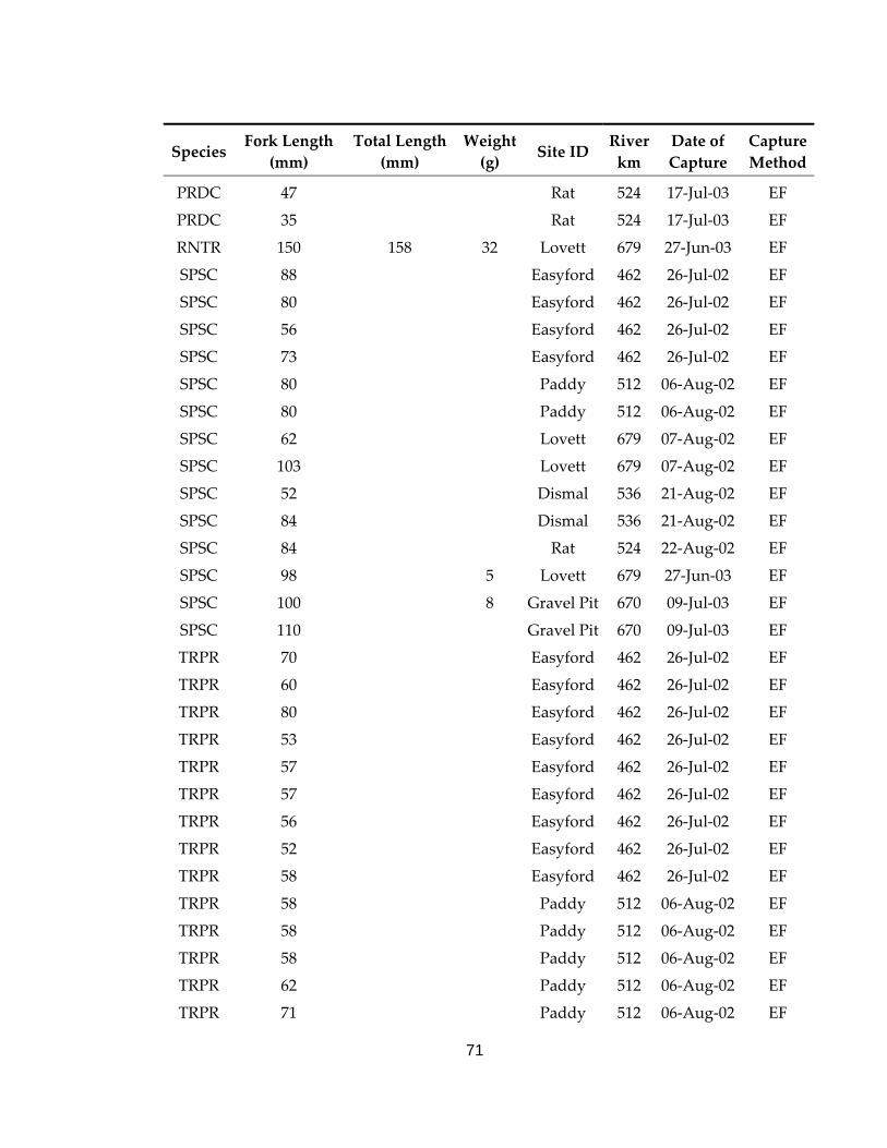
71
Species Fork Length
(mm) Total Length
(mm) Weight (g) Site ID
River km
Date of Capture
Capture Method
PRDC 47 Rat 524 17‐Jul‐03 EF PRDC 35 Rat 524 17‐Jul‐03 EF RNTR 150 158 32 Lovett 679 27‐Jun‐03 EF SPSC 88 Easyford 462 26‐Jul‐02 EF SPSC 80 Easyford 462 26‐Jul‐02 EF SPSC 56 Easyford 462 26‐Jul‐02 EF SPSC 73 Easyford 462 26‐Jul‐02 EF SPSC 80 Paddy 512 06‐Aug‐02 EF SPSC 80 Paddy 512 06‐Aug‐02 EF SPSC 62 Lovett 679 07‐Aug‐02 EF SPSC 103 Lovett 679 07‐Aug‐02 EF SPSC 52 Dismal 536 21‐Aug‐02 EF SPSC 84 Dismal 536 21‐Aug‐02 EF SPSC 84 Rat 524 22‐Aug‐02 EF SPSC 98 5 Lovett 679 27‐Jun‐03 EF SPSC 100 8 Gravel Pit 670 09‐Jul‐03 EF SPSC 110 Gravel Pit 670 09‐Jul‐03 EF TRPR 70 Easyford 462 26‐Jul‐02 EF TRPR 60 Easyford 462 26‐Jul‐02 EF TRPR 80 Easyford 462 26‐Jul‐02 EF TRPR 53 Easyford 462 26‐Jul‐02 EF TRPR 57 Easyford 462 26‐Jul‐02 EF TRPR 57 Easyford 462 26‐Jul‐02 EF TRPR 56 Easyford 462 26‐Jul‐02 EF TRPR 52 Easyford 462 26‐Jul‐02 EF TRPR 58 Easyford 462 26‐Jul‐02 EF TRPR 58 Paddy 512 06‐Aug‐02 EF TRPR 58 Paddy 512 06‐Aug‐02 EF TRPR 58 Paddy 512 06‐Aug‐02 EF TRPR 62 Paddy 512 06‐Aug‐02 EF TRPR 71 Paddy 512 06‐Aug‐02 EF
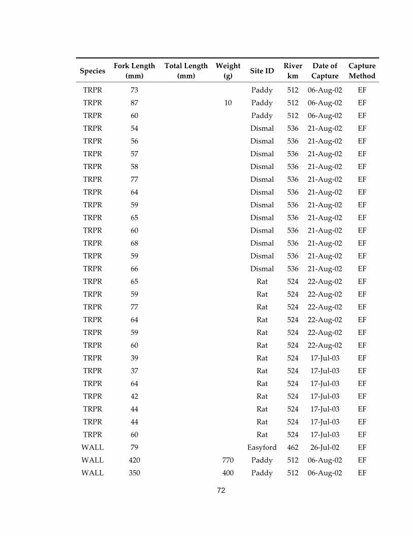
72
Species Fork Length
(mm) Total Length
(mm) Weight (g) Site ID
River km
Date of Capture
Capture Method
TRPR 73 Paddy 512 06‐Aug‐02 EF TRPR 87 10 Paddy 512 06‐Aug‐02 EF TRPR 60 Paddy 512 06‐Aug‐02 EF TRPR 54 Dismal 536 21‐Aug‐02 EF TRPR 56 Dismal 536 21‐Aug‐02 EF TRPR 57 Dismal 536 21‐Aug‐02 EF TRPR 58 Dismal 536 21‐Aug‐02 EF TRPR 77 Dismal 536 21‐Aug‐02 EF TRPR 64 Dismal 536 21‐Aug‐02 EF TRPR 59 Dismal 536 21‐Aug‐02 EF TRPR 65 Dismal 536 21‐Aug‐02 EF TRPR 60 Dismal 536 21‐Aug‐02 EF TRPR 68 Dismal 536 21‐Aug‐02 EF TRPR 59 Dismal 536 21‐Aug‐02 EF TRPR 66 Dismal 536 21‐Aug‐02 EF TRPR 65 Rat 524 22‐Aug‐02 EF TRPR 59 Rat 524 22‐Aug‐02 EF TRPR 77 Rat 524 22‐Aug‐02 EF TRPR 64 Rat 524 22‐Aug‐02 EF TRPR 59 Rat 524 22‐Aug‐02 EF TRPR 60 Rat 524 22‐Aug‐02 EF TRPR 39 Rat 524 17‐Jul‐03 EF TRPR 37 Rat 524 17‐Jul‐03 EF TRPR 64 Rat 524 17‐Jul‐03 EF TRPR 42 Rat 524 17‐Jul‐03 EF TRPR 44 Rat 524 17‐Jul‐03 EF TRPR 44 Rat 524 17‐Jul‐03 EF TRPR 60 Rat 524 17‐Jul‐03 EF WALL 79 Easyford 462 26‐Jul‐02 EF WALL 420 770 Paddy 512 06‐Aug‐02 EF WALL 350 400 Paddy 512 06‐Aug‐02 EF
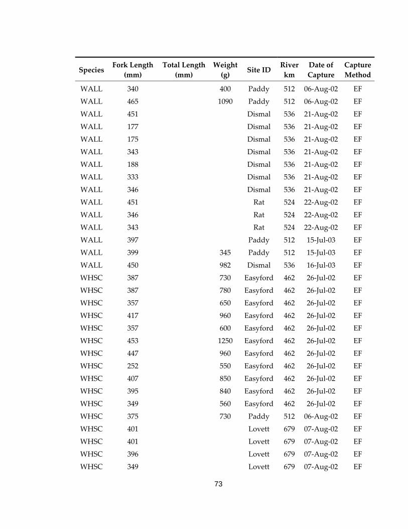
73
Species Fork Length
(mm) Total Length
(mm) Weight (g) Site ID
River km
Date of Capture
Capture Method
WALL 340 400 Paddy 512 06‐Aug‐02 EF WALL 465 1090 Paddy 512 06‐Aug‐02 EF WALL 451 Dismal 536 21‐Aug‐02 EF WALL 177 Dismal 536 21‐Aug‐02 EF WALL 175 Dismal 536 21‐Aug‐02 EF WALL 343 Dismal 536 21‐Aug‐02 EF WALL 188 Dismal 536 21‐Aug‐02 EF WALL 333 Dismal 536 21‐Aug‐02 EF WALL 346 Dismal 536 21‐Aug‐02 EF WALL 451 Rat 524 22‐Aug‐02 EF WALL 346 Rat 524 22‐Aug‐02 EF WALL 343 Rat 524 22‐Aug‐02 EF WALL 397 Paddy 512 15‐Jul‐03 EF WALL 399 345 Paddy 512 15‐Jul‐03 EF WALL 450 982 Dismal 536 16‐Jul‐03 EF WHSC 387 730 Easyford 462 26‐Jul‐02 EF WHSC 387 780 Easyford 462 26‐Jul‐02 EF WHSC 357 650 Easyford 462 26‐Jul‐02 EF WHSC 417 960 Easyford 462 26‐Jul‐02 EF WHSC 357 600 Easyford 462 26‐Jul‐02 EF WHSC 453 1250 Easyford 462 26‐Jul‐02 EF WHSC 447 960 Easyford 462 26‐Jul‐02 EF WHSC 252 550 Easyford 462 26‐Jul‐02 EF WHSC 407 850 Easyford 462 26‐Jul‐02 EF WHSC 395 840 Easyford 462 26‐Jul‐02 EF WHSC 349 560 Easyford 462 26‐Jul‐02 EF WHSC 375 730 Paddy 512 06‐Aug‐02 EF WHSC 401 Lovett 679 07‐Aug‐02 EF WHSC 401 Lovett 679 07‐Aug‐02 EF WHSC 396 Lovett 679 07‐Aug‐02 EF WHSC 349 Lovett 679 07‐Aug‐02 EF
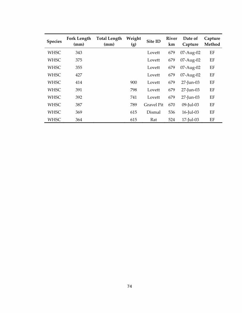
74
Species Fork Length
(mm) Total Length
(mm) Weight (g) Site ID
River km
Date of Capture
Capture Method
WHSC 343 Lovett 679 07‐Aug‐02 EF WHSC 375 Lovett 679 07‐Aug‐02 EF WHSC 355 Lovett 679 07‐Aug‐02 EF WHSC 427 Lovett 679 07‐Aug‐02 EF WHSC 414 900 Lovett 679 27‐Jun‐03 EF WHSC 391 798 Lovett 679 27‐Jun‐03 EF WHSC 392 741 Lovett 679 27‐Jun‐03 EF WHSC 387 789 Gravel Pit 670 09‐Jul‐03 EF WHSC 369 615 Dismal 536 16‐Jul‐03 EF WHSC 364 615 Rat 524 17‐Jul‐03 EF
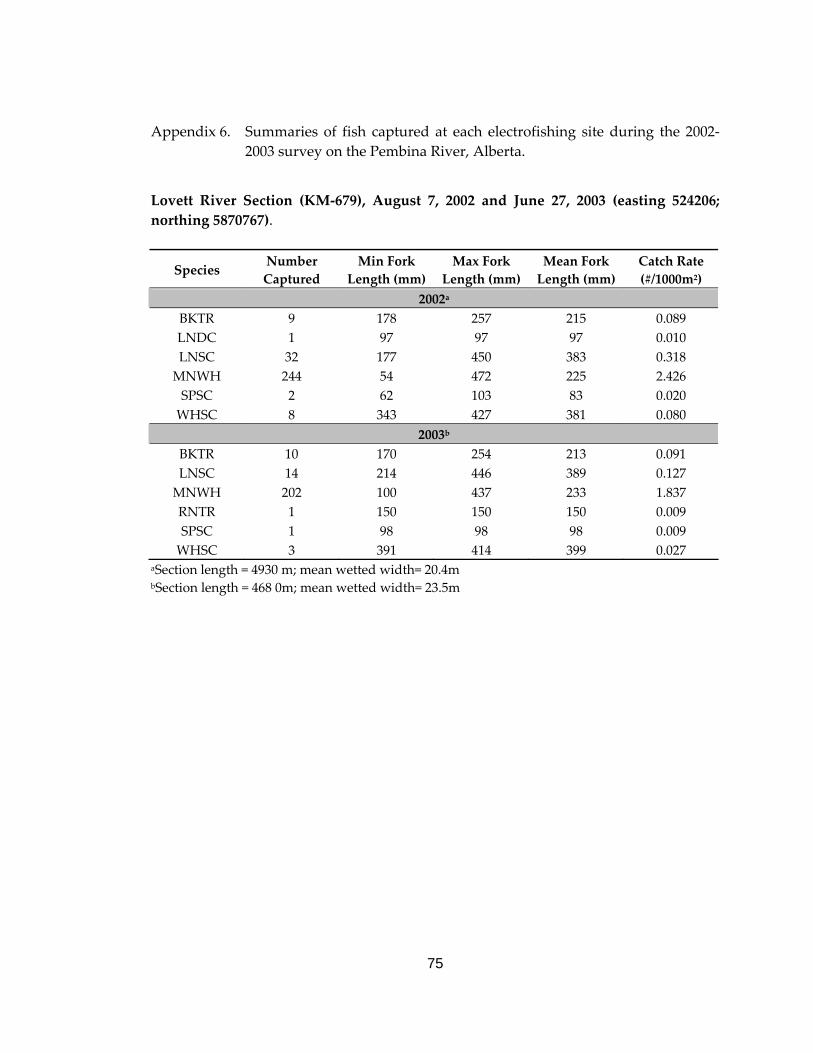
75
Appendix 6. Summaries of fish captured at each electrofishing site during the 2002‐ 2003 survey on the Pembina River, Alberta.
Lovett River Section (KM‐679), August 7, 2002 and June 27, 2003 (easting 524206; northing 5870767).
Species Number Captured
Min Fork Length (mm)
Max Fork Length (mm)
Mean Fork Length (mm)
Catch Rate (#/1000m2)
2002a BKTR 9 178 257 215 0.089 LNDC 1 97 97 97 0.010 LNSC 32 177 450 383 0.318 MNWH 244 54 472 225 2.426 SPSC 2 62 103 83 0.020 WHSC 8 343 427 381 0.080
2003b BKTR 10 170 254 213 0.091 LNSC 14 214 446 389 0.127 MNWH 202 100 437 233 1.837 RNTR 1 150 150 150 0.009 SPSC 1 98 98 98 0.009 WHSC 3 391 414 399 0.027
aSection length = 4930 m; mean wetted width= 20.4m bSection length = 468 0m; mean wetted width= 23.5m
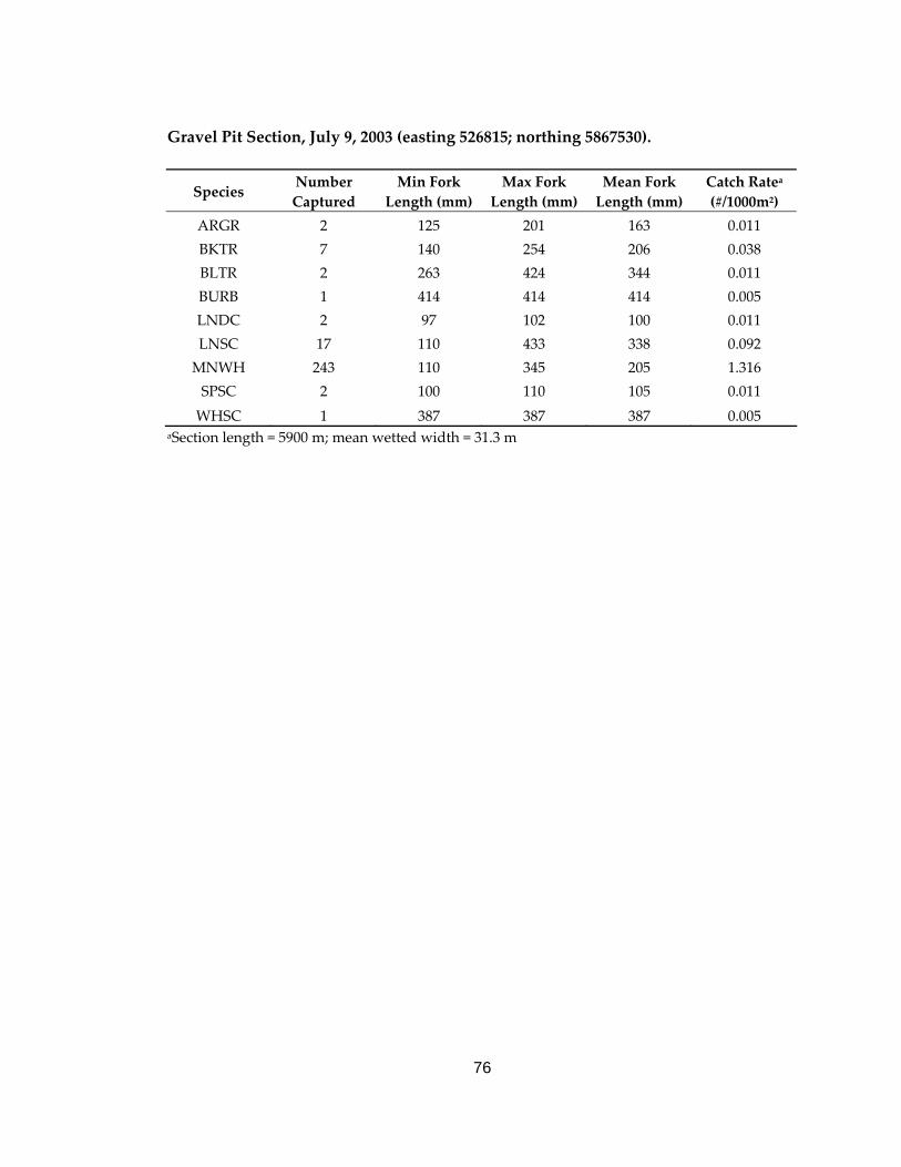
76
Gravel Pit Section, July 9, 2003 (easting 526815; northing 5867530).
Species Number Captured
Min Fork Length (mm)
Max Fork Length (mm)
Mean Fork Length (mm)
Catch Ratea (#/1000m2)
ARGR 2 125 201 163 0.011 BKTR 7 140 254 206 0.038 BLTR 2 263 424 344 0.011 BURB 1 414 414 414 0.005 LNDC 2 97 102 100 0.011 LNSC 17 110 433 338 0.092 MNWH 243 110 345 205 1.316 SPSC 2 100 110 105 0.011 WHSC 1 387 387 387 0.005
aSection length = 5900 m; mean wetted width = 31.3 m
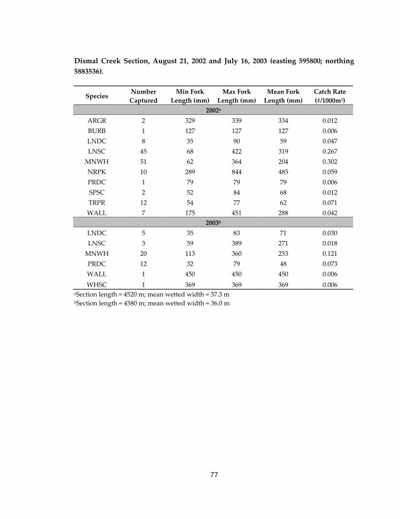
77
Dismal Creek Section, August 21, 2002 and July 16, 2003 (easting 595800; northing 5883536).
Species Number Captured
Min Fork Length (mm)
Max Fork Length (mm)
Mean Fork Length (mm)
Catch Rate (#/1000m2)
2002a
ARGR 2 329 339 334 0.012 BURB 1 127 127 127 0.006 LNDC 8 35 90 59 0.047 LNSC 45 68 422 319 0.267 MNWH 51 62 364 204 0.302 NRPK 10 289 844 485 0.059 PRDC 1 79 79 79 0.006 SPSC 2 52 84 68 0.012 TRPR 12 54 77 62 0.071 WALL 7 175 451 288 0.042
2003b
LNDC 5 35 83 71 0.030 LNSC 3 59 389 271 0.018 MNWH 20 113 360 253 0.121 PRDC 12 32 79 48 0.073 WALL 1 450 450 450 0.006 WHSC 1 369 369 369 0.006
aSection length = 4520 m; mean wetted width = 37.3 m bSection length = 4580 m; mean wetted width = 36.0 m
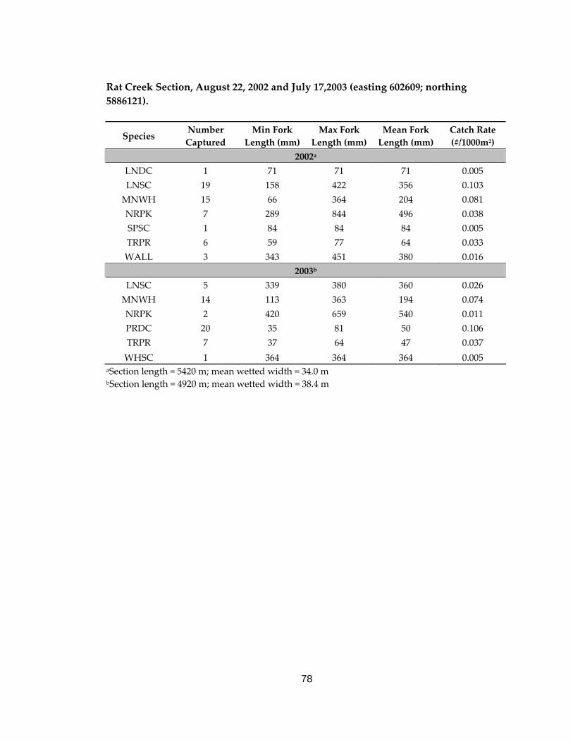
78
Rat Creek Section, August 22, 2002 and July 17,2003 (easting 602609; northing 5886121).
Species Number Captured
Min Fork Length (mm)
Max Fork Length (mm)
Mean Fork Length (mm)
Catch Rate (#/1000m2)
2002a
LNDC 1 71 71 71 0.005 LNSC 19 158 422 356 0.103 MNWH 15 66 364 204 0.081 NRPK 7 289 844 496 0.038 SPSC 1 84 84 84 0.005 TRPR 6 59 77 64 0.033 WALL 3 343 451 380 0.016
2003b
LNSC 5 339 380 360 0.026 MNWH 14 113 363 194 0.074 NRPK 2 420 659 540 0.011 PRDC 20 35 81 50 0.106 TRPR 7 37 64 47 0.037 WHSC 1 364 364 364 0.005
aSection length = 5420 m; mean wetted width = 34.0 m bSection length = 4920 m; mean wetted width = 38.4 m
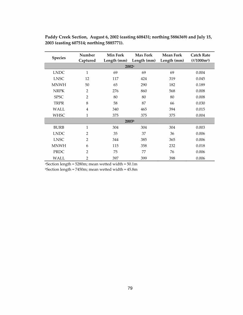
79
Paddy Creek Section, August 6, 2002 (easting 608431; northing 5886369) and July 15, 2003 (easting 607514; northing 5885771).
Species Number Captured
Min Fork Length (mm)
Max Fork Length (mm)
Mean Fork Length (mm)
Catch Rate (#/1000m2)
2002a
LNDC 1 69 69 69 0.004 LNSC 12 117 424 319 0.045 MNWH 50 65 290 182 0.189 NRPK 2 276 860 568 0.008 SPSC 2 80 80 80 0.008 TRPR 8 58 87 66 0.030 WALL 4 340 465 394 0.015 WHSC 1 375 375 375 0.004
2003b
BURB 1 304 304 304 0.003 LNDC 2 35 37 36 0.006 LNSC 2 344 385 365 0.006 MNWH 6 115 358 232 0.018 PRDC 2 75 77 76 0.006 WALL 2 397 399 398 0.006
aSection length = 5280m; mean wetted width = 50.1m bSection length = 7450m; mean wetted width = 45.8m
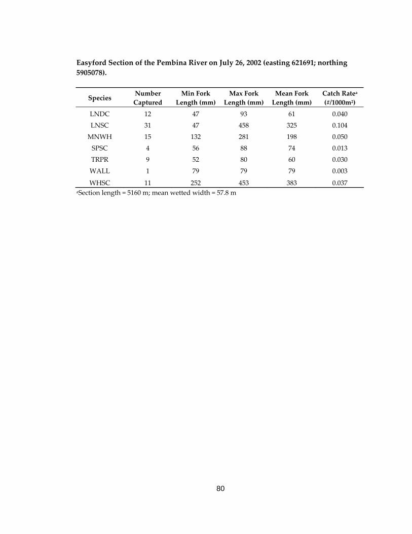
80
Easyford Section of the Pembina River on July 26, 2002 (easting 621691; northing 5905078).
Species Number Captured
Min Fork Length (mm)
Max Fork Length (mm)
Mean Fork Length (mm)
Catch Ratea (#/1000m2)
LNDC 12 47 93 61 0.040
LNSC 31 47 458 325 0.104
MNWH 15 132 281 198 0.050
SPSC 4 56 88 74 0.013
TRPR 9 52 80 60 0.030
WALL 1 79 79 79 0.003
WHSC 11 252 453 383 0.037 aSection length = 5160 m; mean wetted width = 57.8 m
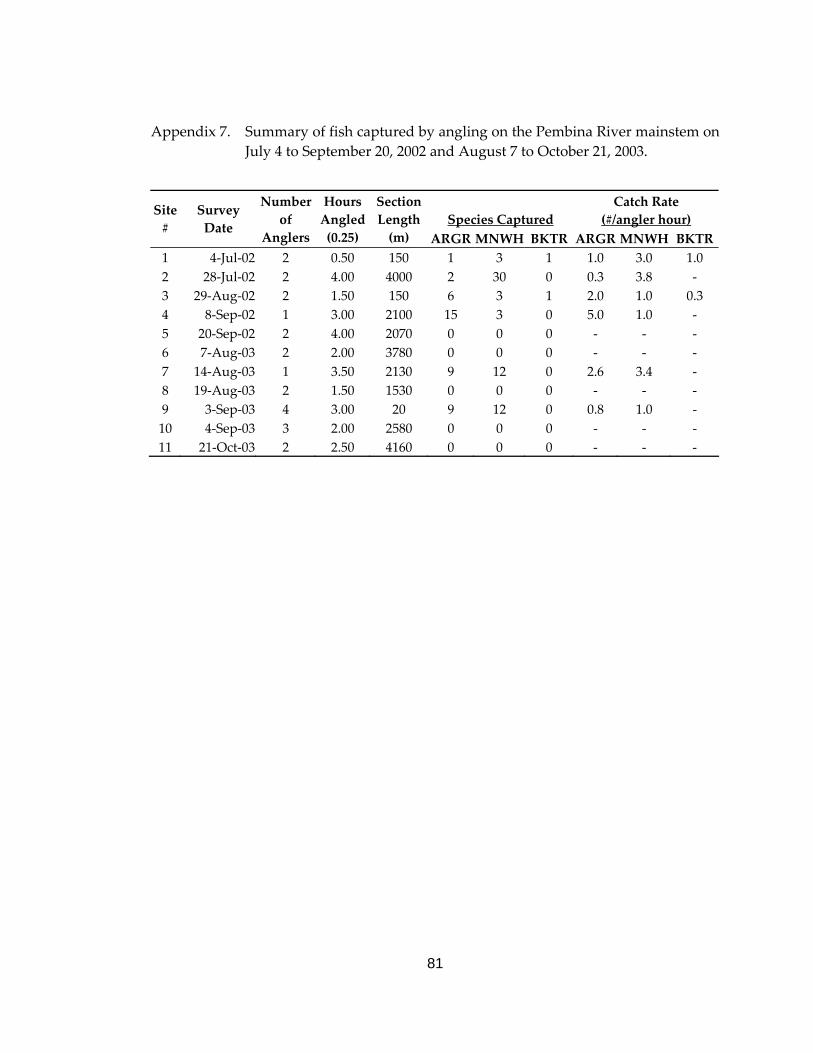
81
Appendix 7. Summary of fish captured by angling on the Pembina River mainstem on July 4 to September 20, 2002 and August 7 to October 21, 2003.
Species Captured Catch Rate
(#/angler hour) Site #
Survey Date
Number of
Anglers
Hours Angled (0.25)
Section Length (m) ARGR MNWH BKTR ARGR MNWH BKTR
1 4‐Jul‐02 2 0.50 150 1 3 1 1.0 3.0 1.0 2 28‐Jul‐02 2 4.00 4000 2 30 0 0.3 3.8 ‐ 3 29‐Aug‐02 2 1.50 150 6 3 1 2.0 1.0 0.3 4 8‐Sep‐02 1 3.00 2100 15 3 0 5.0 1.0 ‐ 5 20‐Sep‐02 2 4.00 2070 0 0 0 ‐ ‐ ‐ 6 7‐Aug‐03 2 2.00 3780 0 0 0 ‐ ‐ ‐ 7 14‐Aug‐03 1 3.50 2130 9 12 0 2.6 3.4 ‐ 8 19‐Aug‐03 2 1.50 1530 0 0 0 ‐ ‐ ‐ 9 3‐Sep‐03 4 3.00 20 9 12 0 0.8 1.0 ‐ 10 4‐Sep‐03 3 2.00 2580 0 0 0 ‐ ‐ ‐ 11 21‐Oct‐03 2 2.50 4160 0 0 0 ‐ ‐ ‐
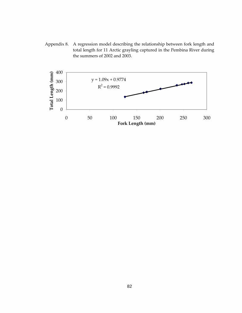
82
Appendix 8. A regression model describing the relationship between fork length and total length for 11 Arctic grayling captured in the Pembina River during the summers of 2002 and 2003.
y = 1.09x + 0.9774R2 = 0.9992
0
100
200
300
400
0 50 100 150 200 250 300Fork Length (mm)
Total Length (mm)
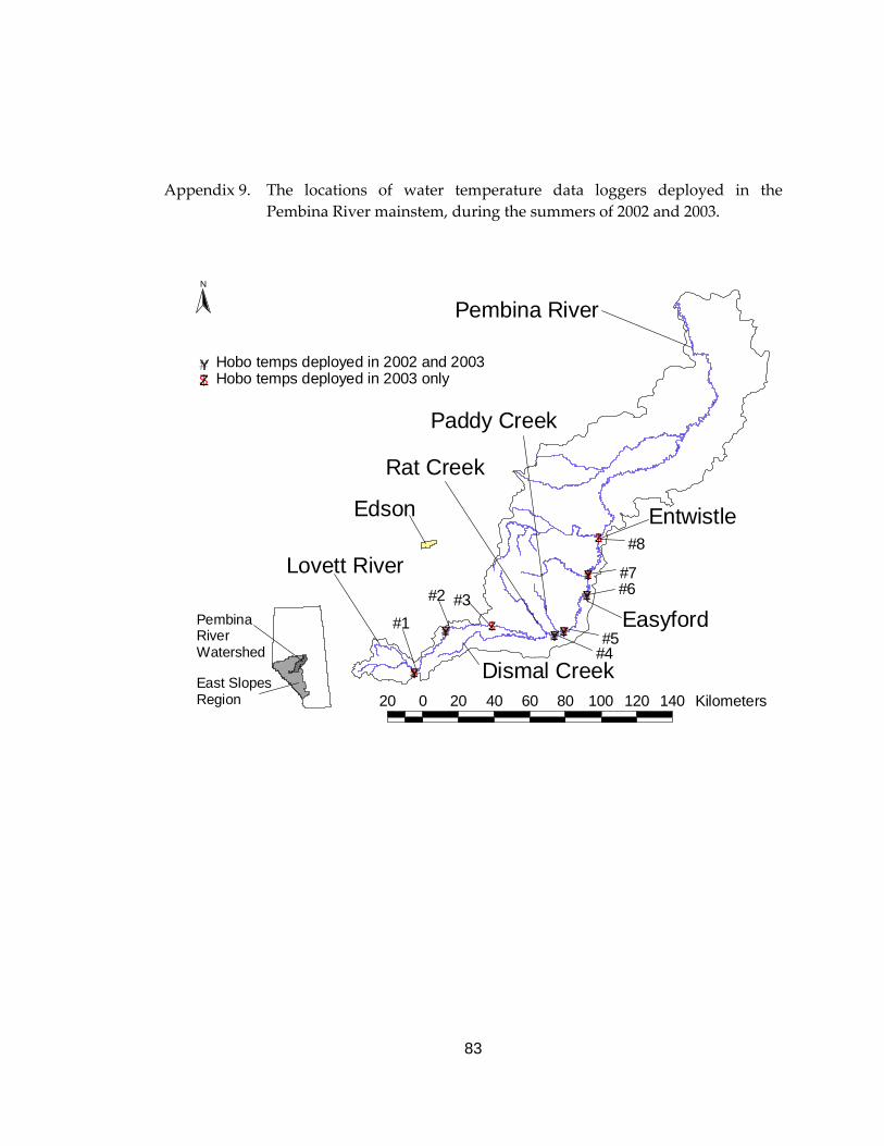
83
Appendix 9. The locations of water temperature data loggers deployed in the Pembina River mainstem, during the summers of 2002 and 2003.
#
Pembina River Watershed
#East SlopesRegion
#
# ##
#
#
#
#
$Z
$Z $Z$Z
$Z
$Z
$Z
$Z
#Y
#Y #Y#Y
#Y#Y
#
Edson
#
Pembina River
#
Lovett River#
Easyford#
Dismal Creek
#
Paddy Creek
#
Rat Creek
##
Entwistle
#
#1 #
#2
#
#3
#
#4
#
#5
##6
# #7
# #8
N
20 0 20 40 60 80 100 120 140 Kilometers
$Z Hobo temps deployed in 2003 only#Y Hobo temps deployed in 2002 and 2003
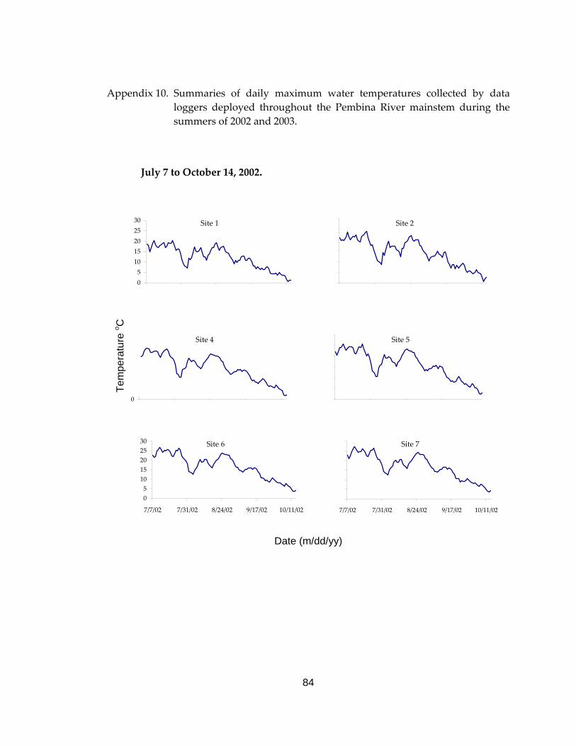
84
Appendix 10. Summaries of daily maximum water temperatures collected by data loggers deployed throughout the Pembina River mainstem during the summers of 2002 and 2003.
July 7 to October 14, 2002.
Site 1
051015202530
7/7/2002 7/31/2002 8/24/2002 9/17/2002 10/11/2002
Site 2
0
5
10
15
20
25
30
7/7/2002 7/31/2002 8/24/2002 9/17/2002 10/11/2002
Site 4
051015202530
7/7/2002 7/31/2002 8/24/2002 9/17/2002 10/11/2002
Site 5
0
5
10
15
20
25
30
7/7/2002 7/31/2002 8/24/2002 9/17/2002 10/11/2002
Site 6
051015202530
7/7/02 7/31/02 8/24/02 9/17/02 10/11/02
Site 7
051015202530
7/7/02 7/31/02 8/24/02 9/17/02 10/11/02
Date (m/dd/yy)
Tem
pera
ture
o C
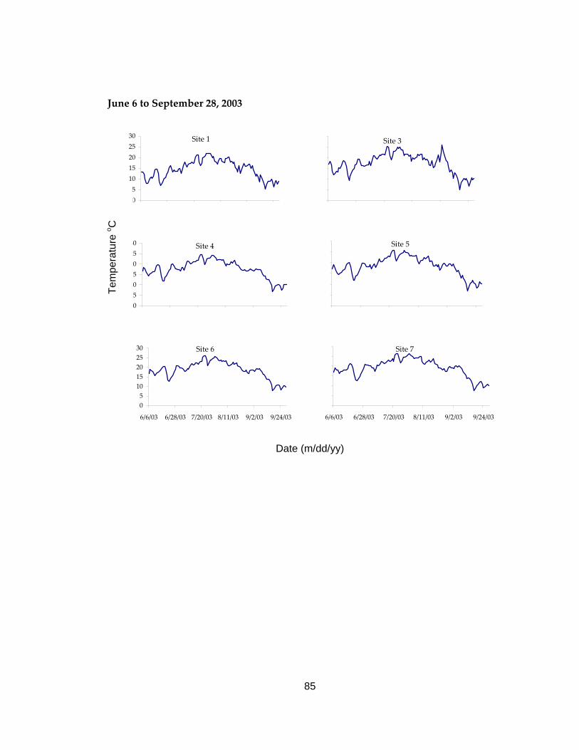
85
June 6 to September 28, 2003
Site 1
051015202530
6/6/2003 6/28/2003 7/20/2003 8/11/2003 9/2/2003 9/24/2003
Site 3
0
5
10
15
20
25
30
6/6/2003 6/28/2003 7/20/2003 8/11/2003 9/2/2003 9/24/2003
Site 4
051015202530
6/6/2003 6/28/2003 7/20/2003 8/11/2003 9/2/2003 9/24/2003
Site 5
0
5
10
15
20
25
30
6/6/2003 6/28/2003 7/20/2003 8/11/2003 9/2/2003 9/24/2003
Site 6
051015202530
6/6/03 6/28/03 7/20/03 8/11/03 9/2/03 9/24/03
Site 7
0
5
10
15
20
25
30
6/6/03 6/28/03 7/20/03 8/11/03 9/2/03 9/24/03
Date (m/dd/yy)
Tem
pera
ture
o C

CONSERVATIONCONSERVATIONREPORT REPORT SERIESSERIES

CONSERVATIONCONSERVATIONREPORT REPORT SERIESSERIES

The Alberta Conservation Association acknowledges the following partner for their generous support of
this project