Embed Size (px)
Citation preview


1
This paper is one in a series issued by the Office of Oceans Affairs, Bureau of Oceans and International Environmental and Scientific Affairs in the Department of State. The aim of the series is to set forth the basis of national arrangements for the measurement of marine areas by coastal States. It is intended for background use only. This paper does not necessarily represent an official acceptance by the United States Government of the limits claimed. Principal analyst for this study: Robert W. Smith. Requests for additional copies should be addressed to the Office of Oceans Affairs, Room 5805, United States Department of State, Washington, D.C. 20520.
LIMITS IN THE SEAS
No. 125
JAMAICA’S
MARITIME CLAIMS AND BOUNDARIES
February 5, 2004
Office of Oceans Affairs Bureau of Oceans and International
Environmental and Scientific Affairs U.S. Department of State

2
Introduction
This study analyzes the maritime claims and boundaries of Jamaica, an island state situated in the central Caribbean Sea, including its claim as an archipelagic State and related claims to archipelagic straight baselines, territorial sea, contiguous zone, and exclusive economic zone (EEZ). Jamaica’s maritime boundaries with Colombia and Cuba will be discussed. The bases for analyzing these claims is the United Nations Convention on the Law of the Sea (LOS Convention) which Jamaica ratified on March 21, 1983.1
Archipelagic straight baselines and the LOS Convention
Article 46 (b) of the LOS Convention states that “archipelago” means a group of islands, including parts of islands, inter-connecting waters and other natural features which are so closely inter-related that such islands, waters and other natural features form an intrinsic geographical, economic, and political entity, or which historically have been regarded as such.
Prior to the Third United Nations Conference on the Law of the Sea (UNCLOS III), several States expressed concerns that baselines may be drawn by archipelagic States in such a manner as to incorporate an excessive amount of water. In 1958, for example, the United Kingdom delegation to the first United Nations Law of the Sea Conference responded to a proposal to include archipelago articles by stating,
“the application of the principle…to widely scattered groups would enclose huge areas of water wholly out of proportion with the land area. Nor would the position be greatly simplified by the new limit to the length of straight baselines…, for wholly artificial baselines might be drawn
between mere reefs and atolls.”2
And, during the UNCLOS III debate leading to the LOS Convention, one country, with a concern similar to the United Kingdom’s, proposed the following for the archipelagic baseline article,
1 The LOS Convention entered into force for those States Parties on November 16, 1994. 2 First Committee, 52nd meeting (1958), para. 38, [First] UN Conference on the Law of the Sea, III Off.Rec. 162, found in UVA Commentary, 400.

3
“…an archipelagic State may employ the method of straight baselines joining the outermost points of the outermost islands of the archipelago, provided that these lines follow the general configuration of the main island or islands and are not drawn to or from isolated islets or reefs. 3
The concern reflected by the above quotes is that by allowing archipelagic baselines to connect isolated reefs, islets, or rocks, a State would enclose waters not forming “an intrinsic geographical, economic and political entity, or which historically have been regarded as such” with the main island(s) of the archipelago. Although the phrase highlighted in the above Cuban proposal was not accepted for the final articles, the drafters placed an area of water to area of land and a baseline length criteria into Article 47 (1) and (2) as an attempt to prevent excessive claims from being made.
Article 47 (1) and (2) state,
“1. An archipelagic State may draw archipelagic straight baselines joining the outermost points of the outermost islands and drying reefs of the archipelago provided that within such baselines are included the main islands and an area in which the ratio of the area of the water to the area of the land, including atolls, is between 1 to 1 and 9 to 1.
“2. The length of such baselines shall not exceed 100 nautical miles, except that up to 3 per cent of the total number of baselines enclosing any archipelago may exceed that length, up to a maximum length of 125 nautical miles.”
Jamaica’s Archipelagic Claim
Archipelagic straight baselines: Jamaica’s archipelagic straight baselines have been plotted on, and on which this analysis is based, U.S. NGA chart 26120.4 The archipelagic baseline system is depicted on the attached page-sized map for illustration purposes only.
Jamaica is comprised of one main island and about a half dozen small rocks, islets and cays generally situated about 60 miles south of the main island.5 Archipelagic straight baselines connect the main island to a rock, Southwest Rock and to a series of small cays, Morant Cays. Morant Cays and Southwest Rock 3 Amendment to document A/CONF.62/C.2/L.70, submitted by Cuba, document A/Conf.62/C.2/L.73, Official Records 237, found in United Nations Archipelagic States: Legislative History of Part IV of the UN Convention on the Law of the Sea, 1990, 38.Emphasis added. 4 55th edition, July 26, 1980, 1:300,000. NGA, the National Geospatial Intelligence Agency is the former National Imagery and Mapping Agency (NIMA) and the former Defense Mapping Agency (DMA). 5 All miles in this study, unless otherwise specified, are nautical miles. One nautical mile equals 1, 852 meters.
4
are, in turn, connected by straight lines to Blower Rock. While Jamaica may not be the model archipelagic State the negotiators had in mind when they developed the archipelagic legal regime during UNCLOS III, it nevertheless meets the criteria set forth in Part IV of the Convention.6
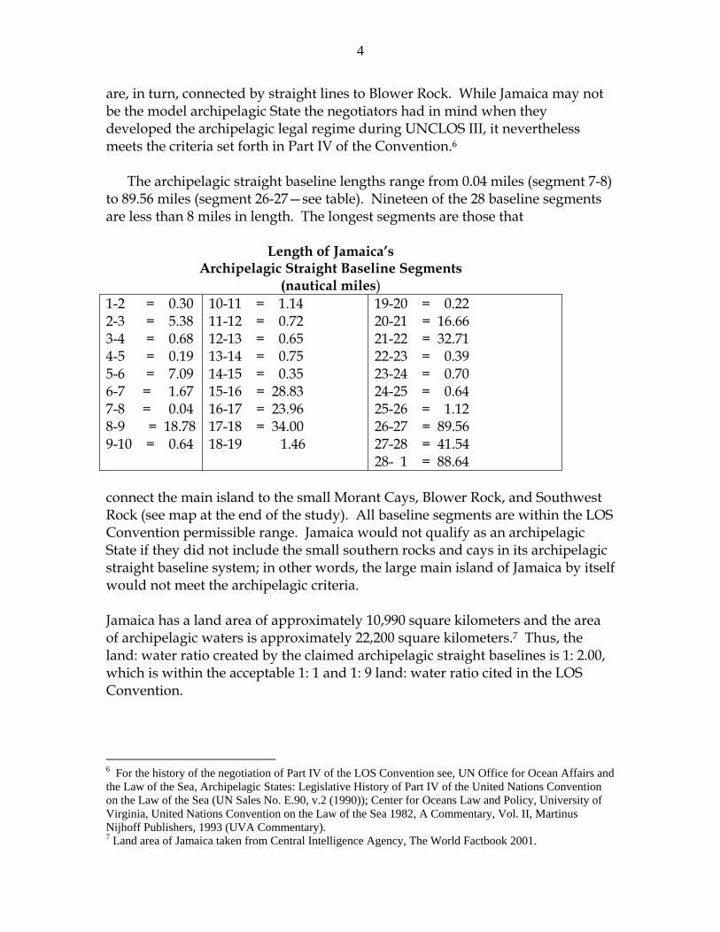
The archipelagic straight baseline lengths range from 0.04 miles (segment 7-8) to 89.56 miles (segment 26-27—see table). Nineteen of the 28 baseline segments are less than 8 miles in length. The longest segments are those that
Length of Jamaica’s Archipelagic Straight Baseline Segments
(nautical miles) 1-2 = 0.30 2-3 = 5.38 3-4 = 0.68 4-5 = 0.19 5-6 = 7.09 6-7 = 1.67 7-8 = 0.04 8-9 = 18.78 9-10 = 0.64
10-11 = 1.14 11-12 = 0.72 12-13 = 0.65 13-14 = 0.75 14-15 = 0.35 15-16 = 28.83 16-17 = 23.96 17-18 = 34.00 18-19 1.46
19-20 = 0.22 20-21 = 16.66 21-22 = 32.71 22-23 = 0.39 23-24 = 0.70 24-25 = 0.64 25-26 = 1.12 26-27 = 89.56 27-28 = 41.54 28- 1 = 88.64
connect the main island to the small Morant Cays, Blower Rock, and Southwest Rock (see map at the end of the study). All baseline segments are within the LOS Convention permissible range. Jamaica would not qualify as an archipelagic State if they did not include the small southern rocks and cays in its archipelagic straight baseline system; in other words, the large main island of Jamaica by itself would not meet the archipelagic criteria.
Jamaica has a land area of approximately 10,990 square kilometers and the area of archipelagic waters is approximately 22,200 square kilometers.7 Thus, the land: water ratio created by the claimed archipelagic straight baselines is 1: 2.00, which is within the acceptable 1: 1 and 1: 9 land: water ratio cited in the LOS Convention.
6 For the history of the negotiation of Part IV of the LOS Convention see, UN Office for Ocean Affairs and the Law of the Sea, Archipelagic States: Legislative History of Part IV of the United Nations Convention on the Law of the Sea (UN Sales No. E.90, v.2 (1990)); Center for Oceans Law and Policy, University of Virginia, United Nations Convention on the Law of the Sea 1982, A Commentary, Vol. II, Martinus Nijhoff Publishers, 1993 (UVA Commentary). 7 Land area of Jamaica taken from Central Intelligence Agency, The World Factbook 2001.

5
An interesting issue that arises when one analyzes the Jamaican archipelagic straight baseline system is the role that rocks play in determining whether Jamaica is an archipelagic State. In the south, several of the basepoints are situated on very small features, features that could possibly qualify as Article 121 (3) “rocks”. Article 121 (3) states that;
“Rocks which cannot sustain human habitation or economic life of their own shall have no exclusive economic zone or continental shelf.”
While no definition has been given as to what is meant by the ability to “sustain human habitation or economic life of their own”, it is quite possible the negotiators of the LOS Convention intended for this article to apply to features such as those found in the southern waters of Jamaica. However, whereas States do not enjoy the right to claim an exclusive economic zone or continental shelf from an Article 121 (3) rock, there is no provision in the LOS Convention limiting such claims if these same features form a part of the archipelagic baseline system.
Due publicity: In accordance with Article 47 (9) of the LOS Convention, the archipelagic State shall give due publicity to the charts or lists of geographical co-ordinates and shall deposit such charts or lists with the Secretary-General of the United Nations.
In 1996 Jamaica fulfilled this requirement when it deposited with the United Nations its The Exclusive Economic Zone Act (Baselines) regulations, 12 October 1992, which the United Nations has published in its Law of Sea Bulletin No. 32, 1996 (page 41).8 This October 1992 regulation mentions that official charts have been signed by the Minister and which shall be deposited and displayed at the Survey Department. No charts have been specified nor have any been deposited with the United Nations.
Navigation rights: Within archipelagic waters ships of all States have certain navigation rights. Subject to various provisions of the LOS Convention, ships enjoy the right of innocent passage through the archipelagic waters. The archipelagic State can, without discrimination among foreign ships, suspend temporarily in specified areas of the archipelagic waters innocent passage if such suspension is essential for the protection of its security (Article 52, LOS Convention).
Within certain areas of the archipelagic waters foreign ships enjoy archipelagic sea lanes passage. According to Article 53 (1), “ an archipelagic
8 This regulation is reprinted at Annex 1 of this study.

6
State may designate sea lanes and air routes thereabove, suitable for the continuous and expeditious passage of foreign ships and aircraft through or over its archipelagic waters and the adjacent territorial sea.” This archipelagic sea lanes passage allows ships to transit in their “normal mode”, meaning e.g., submarines can transit submerged and naval battle groups may transit in a way that afford them the normal protection they would have in any body of water.
If an archipelagic State designates archipelagic sea lanes they must abide by certain criteria set forth in Article 53, which includes referring proposals for such sea lane designation to “the competent international organization”, which would be the International Maritime Organization, based in London. If an archipelagic State does not designate archipelagic sea lanes, then archipelagic sea lanes passage “may be exercised through the routes normally used for international navigation.” (Article 43(12)).
Jamaica’s Maritime Claims
It is from these archipelagic straight baselines that Jamaica measures its 12 mile territorial sea (first claimed in 1971)9, 24-mile contiguous zone, and exclusive economic zone. Due to its location in the central Caribbean Sea, Jamaica is not able to extend its exclusive economic zone claim to a full 200 miles, but its outer limits are defined by negotiated and potential maritime boundaries.
Maritime Areas Square nautical miles (square kilometers)
Jamaica—land area 3,204 ( 10,990) Archipelagic waters 6,424 ( 22,000) Territorial sea 5,255 ( 17,995) Contiguous Zone 6,139 ( 21,055) Exclusive Economic Zone 52,826 (181,190)10
Joint Regime (with Colombia) 15,171 ( 52,036)
Jamaica’s water to land ratio, for the purpose of meeting the LOS Convention’s archipelagic state criteria, is 2.00: 1. Its territorial sea incorporates an area of approximately 5, 255 square nautical miles and its contiguous zone adding another 6,139 square nautical miles. Not including the joint regime it has
9 Act No. 14, July 19, 1971. The claim was reiterated in Maritime Areas Act, Act 25 of 1996, which went into force November 28, 1996. 10 Area of Joint Regime is not included in the exclusive economic zone area.

7
created with Colombia, the Jamaican EEZ encloses about 52, 826 square nautical miles of ocean space, about the size of the state of Missouri or more than 18 times the size of Jamaica’s land territory).

8
Jamaica’s Maritime Boundaries
As of the beginning of 2004, Jamaica had negotiated maritime boundaries with Colombia and with Cuba. Future negotiations will be needed with the United States, Haiti, Honduras, and the United Kingdom.
Jamaica- Colombia: Jamaica’s boundary agreement with Colombia was signed 12 November 1993 and, upon the exchange of instruments of ratification, entered into force 14 March 1994. There are several significant aspects to this agreement.
11
First, a maritime boundary is established in Article 1, consisting of four segments that extends for approximately 250 miles in a general east-west direction. According to the agreement, the terminus in the east is uncertain depending on the to-be-determined tripoint among Colombia, Jamaica, and Haiti.
Second, a Joint Regime Area is created in Article 3 that is situated to the northwest of the boundary. This “zone of joint management, control, exploration and exploitation of the living and non-living resources: is created “pending the determination of the jurisdictional limits of each Party in the area designated below [in which a series of geographic coordinates are given]”.
Third, the Joint Regime Area excludes the 12-mile zone drawn around Serranilla Cays and Bajo Nuevo.12
Although the maritime boundary approximates an equidistant line between the two countries it is equidistance measured from the main Jamaican island and not the small cays in the south nor the archipelagic straight baselines.
Jamaica- Cuba: These two States signed a maritime boundary agreement on February 18, 1994 and it entered into force on July 18, 1995.13 The boundary consists of 106 turning points. The agreement states that to the west of point 106 the boundary will continue “in a westerly direction to a point to be determined
11 For the text and a detailed analysis of this agreement, see Colombia-Jamaica, International Maritime Boundaries Vol III, Charney and Alexander (eds), pp.2179-2204. The text may also be found at Annex 2 of this study, United Nations Law of the Sea Bulletin, Vol. 26, page 50 (1994), and http://www.UN.org/Depts/LOS/Legislatioinand treaties/Statefiles/Jam.htm. 12 The question of sovereignty over the features of Serranilla Bank and Bajo Nuevo is not settled. The United States, among others, has long maintained a sovereignty claim over them, dating to the Guano Act of 1856. 13 For the text and a detailed analysis of this agreement. See Cuba-Jamaica, International Maritime Boundaries, Vol. III, Charney and Alexander (eds), pp. 2205-2218. The text may also be found at Annex 3 of this study, at United Nations Law of the Sea Bulletin, Vol. 34, p.64 (1997), and website cited in note 11 above.

9
by subsequent agreement” (which would involve the United Kingdom and its Cayman Islands). Although the agreement does not cite any similar circumstances in the east, there will be a tripoint agreement required with the United States, regarding Navassa Island.14
14 Navassa Island is disputed between the United States and Haiti.

10
Annex 1
The Exclusive Economic Zone Act (Baselines) regulations, 12 October 199215
In exercise of the power conferred upon the Minister by section 21(a) of the Exclusive Economic Zone Act, the following regulations are hereby made:
1. These Regulations may be cited as the Exclusive Economic Zone (Baselines) regulations, 1992.
2. The charts which:
(a) indicate the geographical coordinates (as set out in the Schedule) constituting the basepoints of Jamaica and the outlying islands of Pedro Cays and the Morant Cays to be joined by straight archipelagic baselines; and
(b) contain any notation, reference and other information as may be necessary; and (c) [are] signed by the Minister,
are the official charts indicating baselines from which the breadth of the exclusive economic zone of Jamaica is measured and shall be deposited in and displayed at the Survey Department.
3. In any proceedings in any court of law, a chart referred to in paragraph 2 or a copy thereof certified a true copy by the Director of Surveys shall be admissible in evidence as proof of the contents thereof.
SCHEDULE
Geographical coordinates defining the basepoints to be joined by archipelagic baselines around the mainland and the
outlying islands of Jamaica
Point No. Latitude (N) Longitude (W) 1. 18° 15’ 51” 78° 22’ 06” 2. 18° 16’ 09” 78° 22’ 06” 3. 18° 21’ 23” 78° 20’ 43” 4. 18° 21’ 57” 78° 20’ 19” 5. 18° 22’ 06” 78° 20’ 12” 6. 18° 26’ 23” 78° 14’ 15” 7. 18° 27’20” 78° 12’ 48” 8. 18° 27’ 21” 78° 12’ 46” 9. 18° 31’ 09” 77° 53’ 25”
10. 18° 31’15” 77° 52’ 45” 11. 18° 31’ 25” 77° 51’ 34” 12. 18° 31’30” 77° 50’ 49” 13. 18° 31’ 30” 77° 50’ 08” 14. 18° 31’ 28” 77° 49’ 21”
15 Text found in United Nations Law of the Sea Bulletin No. 32, 41-42and web site cited in note 11, above.

11
Point No. Latitude (N) Longitude (W) 15. 18° 31’ 26” 77° 48’ 59” 16. 18° 28’ 22” 77° 18’ 49” 17. 18° 24’ 43” 76° 53’ 54” 18. 18° 10’ 05” 76° 21’ 37” 19. 18° 09’ 20” 76° 20’ 18” 20. 18° 09’ 10” 76° 20’ 09” 21. 17° 55’ 02” 76° 10’ 48” 22. 17° 24’ 39” 75° 57’ 48” 23. 17° 24’ 16” 75° 57’ 53” 24. 17° 23’ 42” 75° 58’ 19” 25. 17° 23’ 22” 75° 58’ 53” 26. 17° 23’ 01” 76° 00’ 00” 27. 17° 02’ 28” 77° 31’ 05” 28. 16° 47’ 26” 78° 11’ 30”
Note: These positions are referenced to the 1927 North American Datum (NAD27) and based on Clarke’s (1866) spheroid with a semimajor axis of 6378206.4 metres and a flattening of 1/294.978.

12
Annex 2
Maritime Delimitation Treaty Between Jamaica and The Republic of Colombia16
Signed: 12 November 1993 Entered into Force: 14 March 1994
The Government of Jamaica and the Government of the Republic of Colombia; Considering the bonds of friendship existing between both countries;
Recognizing the common interests of both countries in considering issues related to the rational exploitation, management and conservation of the maritime areas between them, including questions relating to the exploitation of living resources; Acknowledging the interests which both countries have in concluding a maritime delimitation treaty;
Taking into account recent developments in the law of the sea; Desirous of delimiting the maritime areas between both countries on the basis of mutual respect, sovereign equality and the relevant principles of international law; Agree as follows:
Article 1
The maritime boundary between Jamaica and the Republic of Colombia is constituted by geodesic lines drawn between the following points:
Point Latitude (North) Longitude (West) 1. 14° 29’ 37” 78° 38’ 00” 2. 14° 15’ 00” 78° 19’ 30” 3. 14° 05’ 00” 77° 40’ 00” 4. 14° 44’ 10” 74° 30’ 50” 5. From point 4, the delimitation line proceeds by a geodesic line in the direction
to another point with the coordinates 15° 02’ 00”N, 73° 27’ 30” W, as far as the delimitation line to be decided between Jamaica and Haiti.
Article 2
Where hydrocarbon or natural gas deposits, or fields are found on both sides of the delimitation line established in Article 1, they shall be exploited in a manner such that the distribution of the volumes of the resource extracted from said deposit or fields is
proportional to the volume of the same which is correspondingly found on each side of the line.
16 Text can also be found in 26 United Nations Law of the Sea Bulletin 50 (1194); J. Charney and L.M. Alexasnder (eds), International Maritime Boundaries, Report 2-18, 2200-2204, 1998, The American Society of International Law, and at website cited in note 11, above.

13
Article 3
Pending the determination of the jurisdictional limits of each Party, in the area designated below, the Parties agree to establish therein a zone of joint management, control, exploration and exploitation of the living and non-living resources, hereafter called ’The Joint Regime Area’. (a) The Joint Regime Area is established by the closed figure described by the lines joining the following points in the order in which they occur. The lines so joining the listed points are geodesic lines unless specifically stated otherwise.
Point Latitude (North) Longitude (West) 1. 16° 04’ 15” 79° 50’ 32” 2. 16° 04’ 15” 79° 29’ 20” 3. 16° 10’ 10” 79° 29’ 20” 4. 16° 10’ 10” 79° 16’ 40” 5. 16° 04’ 15” 79° 16’ 40” 6. 16° 04’ 15” 78° 25’ 50” 7. 15° 36’ 00” 78° 25’ 50” 8. 15° 36’ 00” 78° 38’ 00” 9. 14° 29’ 37” 78° 38’ 00” 10. 15° 30’ 10” 79° 56’ 00” 11. 15° 46’ 00” 80° 03’ 55”
The limit of the Joint Regime Area then continues along the arc of 12 nautical miles radius centered on a point at 15° 47’ 50”N, 79° 51’ 20”W, such that it passes to the west of Serranilla Cays to a point at 15° 58’ 40”N, 79° 56’ 40” W. The figure is then closed by the geodesic line to Point 1. (b) The Joint Regime Area excludes the maritime area around the cays of Serranilla Bank comprised within the outermost arc of the circle of 12 nautical miles radius centred at a point 15° 58’ 40” N, 79° 51’ 20” W, such that it passes through points 15° 46’ 00” N, 80° 03’ 55” W and 15° 58’ 40” N, 79° 56’ 40” W. (c) The Joint Regime Area will also exclude the maritime area around the cays of Bajo Nuevo comprised within the outermost arc of the circle of 12 nautical miles radius centered at the point 15° 51’ 00” N, 78° 38’ 00” W.
2. In the Joint Regime Area, the Parties may carry out the following activities: (a) Exploration and exploitation of the natural resources, whether living or non-
living, of the waters superjacent to the seabed and the seabed and its subsoil, and other activities for the economic exploitation and exploration of the Joint Regime Area; (b) The establishment and use of artificial islands, installations and structures; (c) Marine scientific research; (d) The protection and preservation of the marine environment; (e) The conservation of living resources; (f) Such measures as authorized by this Treaty, or as the Parties may otherwise agree for ensuring compliance with and enforcement of the regime established by this Treaty.

14
3. Activities relating to exploration and exploitation of non-living resources as well as those referred to in paragraph 2 (c) and (d), will be carried out on a joint basis agreed by both Parties.
4. The Parties shall not authorize third States and international organizations or vessels of such States and organizations to carry out any of the activities referred to in paragraph 2. This does not preclude a Party from entering into, or authorizing arrangements for leases, licenses, joint ventures and technical assistance programmes in order to facilitate the exercise of the rights pursuant to paragraph 2, in accordance with the procedures established in article 4.
5. The Parties agree that in the Joint Regime Area, each Party has jurisdiction over its nationals and vessels flying its flag or over which it exercises management and control in accordance with international law. Provided that in any case where it is alleged by one Party that nationals or vessels of the other Party have breached, or are breaching the provisions of this Treaty and any measures adopted by the Parties for their implementation, the Party alleging the breach shall bring it to the attention of the other Party, following which both Parties shall forthwith commence consultations with a view to arriving at an amicable settlement within 14 days. On receipt of the allegation, the Party to whose attention the allegation has been brought shall, without prejudice to the consultations referred to in the above paragraph:
(a) In relation to an allegation that a breach has been committed, ensure that the activities, the subject matter of the allegation, do not recur.
(b) In relation to an allegation that a breach is being committed, ensure that the activities are discontinued.
6. The Parties agree to adopt measures for ensuring that nationals and vessels of third States comply with any regulations and measures adopted by the Parties for implementing the activities set out in paragraph 2.
Article 4
1. The Parties agree to establish a Join Commission, hereinafter called “The Joint Commission”, which shall elaborate the modalities for the implementation and the carrying out of the activities set out in paragraph 2, or article 3, the measures adopted pursuant to paragraph 6 of article 3, and carry out any other functions which may be assigned to it by the Parties for the purpose of implementing the provisions of this Treaty.
2. The Joint Commission shall consist of one representative of each Party, who may be assisted by such advisers as is considered necessary.
3. Conclusions of the Joint Commission shall be adopted by consensus and shall be only recommendations to the Parties. Conclusions of the Joint Commission when adopted by the Parties shall become binding on the Parties.

15
4. The Joint Commission shall begin its work immediately on the entry into force of this Treaty and shall, unless the Parties agree otherwise, conclude the tasks identified in paragraph 1 of this article within six months from the commencement of its work.
Article 5
Geodetic data are based on the World Geodetic System (1984).
Article 6
For illustrative purposes only, the delimitation line and the Joint Regime Area are shown on a United States Defense Mapping Agency Chart 402, which is attached. In the event of conflict between the coordinates and the Chart, the coordinates will prevail.
Article 7
Any dispute between the Parties on the interpretation or application of this Treaty shall be settled by agreement between the two countries in accordance with the means for the peaceful settlement of disputes provided for by international law.
Article 8
This Treaty shall be subject to ratification.
Article 9
This Treaty shall enter into force on the date of exchange of instruments of ratification.
Article 10
Done in English and Spanish, each text being equally authentic.
INWITNESS WHEREOF, the Ministers for Foreign Affairs of both countries have signed the present Treaty.
Done at Kingston this 12th day of November 1993.

16
Annex 3
Agreement between the Government of Jamaica And the Government of the Republic of Cuba on the
Delimitation of the Maritime Boundary between the two States17
Signed: 18 February 1994 Entered into force: 18 July 1995
The Government of Jamaica and the Government of the Republic of Cuba: Reaffirming the close and traditional bonds of friendship, mutual respect and understanding existing between the two Caribbean States; Conscious of the duty to safeguard for their peoples the renewable and non-renewable natural resources, found in marine and submarine areas, subject to their respective sovereignty, sovereign rights and jurisdiction; Acknowledging that cooperation between states, particularly between states in the same region is necessary for the exploration, exploitation, conservation and rational management of living and non-living resources; Taking into account the relevant provisions of the United Nations Convention on the Law of the Sea, adopted in Montego Bay, Jamaica on 10 December 1982 to which Cuba and Jamaica are Parties, and which will enter into force on 16 November 1994; Prompted by the desire to establish limits between their respective maritime zones on the basis of the principles of mutual respect and sovereign equality; Agree as follows:
Article 1 The Government of Jamaica and the Government of the Republic of Cuba agree that the equidistance method is the equitable solution for the establishment of the delimitation line between their exclusive economic zones and the continental shelves.
Article 2
(1) The delimitation line referred to in Article 1 is constituted by geodesic lines determined by the following points:
Point Latitude (North)
Longitude (West)
Point Latitude (North)
Longitude (West)
1 18° 49’ 56” 75° 30’ 23 54 19° 09’ 35” 76° 59’ 31” 2 18° 50’ 45” 75° 31’ 41” 55 19° 09’ 45” 77° 01’ 48” 3 18° 51’ 40” 75° 32’ 36” 56 19° 09’ 51” 77° 02’ 49” 4 18° 51’ 10” 75° 34’ 09” 57 19° 09’ 57” 77° 04’ 04” 5 18° 55’ 06” 75° 41’ 55” 58 19° 10’ 00” 77° 04’ 42” 6 18° 55’ 40” 75° 43’ 19” 59 19° 10’ 05” 77° 05’ 37” 7 18° 58’ 28” 75° 50’ 24” 60 19° 10’ 04” 77° 06’ 22” 8 18° 58’ 43” 75° 51’ 02” 61 19° 10’ 04” 77° 07’ 09” 9 18° 59’ 52” 75° 53’ 57” 62 19° 10’ 04” 77° 07’ 09” 10 19° 00’ 40” 75° 56’ 05” 63 19° 10’ 01” 77° 09’ 28”
17 Text of agreement can also be found in website cited in note 11 above.

17
Point Latitude(North)
Longitude (West)
Point Latitude(North)
Longitude (West)
11 19° 01’ 00” 75° 57’ 03” 64 19° 09’ 59” 77° 11’ 00” 12 19° 01’ 19” 75° 57’ 53” 65 19° 09’ 59” 77° 11’ 38” 13 19° 01’ 27” 75° 58’ 31” 66 19° 09’ 55” 77° 14’ 30” 14 19° 01’ 33” 75° 58’ 53” 67 19° 09’ 54” 77° 15’ 10” 15 19° 01’ 44” 75° 59’ 46” 68 19° 09’ 53” 77° 16’ 03” 16 19° 02’ 03” 76° 01’ 15” 69 19° 09’ 50” 77° 16’ 35” 17 19° 02’ 34” 76° 03’31” 70 19° 09’ 50” 77° 18’ 21” 18 19° 03 08” 76° 05’ 45” 71 19° 09’ 51” 77° 20’ 39” 19 19° 03’ 37” 76° 07’ 31” 72 19° 09’ 55” 77° 22’ 56” 20 19° 03’ 44” 76° 07’ 59” 73 19° 10’ 00” 77° 24’ 30” 21 19° 04’ 08” 76° 09’ 25” 74 19° 10’ 01” 77° 25’ 05” 22 19° 04’ 20” 76° 10’ 12” 75 19° 10’ 01” 77° 25’ 10” 23 19° 04’ 40” 76° 11’ 25” 76 19° 10’ 06” 77° 26’ 52” 24 19° 04’ 49” 76° 12’ 30” 77 19° 10’ 07” 77° 27’ 38” 25 19° 05’ 10” 76° 14’ 51” 78 19° 10’ 10” 77° 28’ 31” 26 19° 05’ 33” 76° 17’ 11” 79 19° 10’ 11” 77° 29’ 13” 27 19° 05’ 59” 76° 19’ 29” 80 19° 10’ 11” 77° 29’ 46” 28 19° 06’ 08” 76° 20’ 10” 81 19° 10’ 11” 77° 29’ 47” 29 19° 06’ 26” 76° 21’ 47” 82 19° 10’ 09” 77° 32’ 04” 30 19° 06’ 34 “ 76° 22’ 28” 83 19° 10’ 09” 77° 32’ 05” 31 19 ° 06’ 53” 76° 24’ 05” 84 19° 10’ 07” 77° 34’ 02” 32 19° 07’ 01” 76° 24’46” 85 19° 10’ 06” 77° 34’ 23” 33 19° 07’ 19” 76° 26’ 24” 86 19° 10’ 08” 77° 36’ 41” 34 19° 07’ 24” 76° 26’ 47” 87 19° 10’ 08” 77° 38’ 58” 35 19° 07’ 42” 76° 28’ 19” 88 19° 10’ 14” 77° 41’ 15” 36 19° 07’ 46” 76° 28’ 42” 89 19° 10’ 24” 77° 43’ 30” 37 19° 07’ 50” 76° 29’ 04” 90 19° 10’ 34” 77° 45’ 15” 38 19° 08’ 10” 76° 30’ 53” 91 19° 10’ 43” 77° 46’ 47” 39 19° 08’ 12” 76° 31’ 00” 92 19° 10 48” 77° 47’ 54” 40 19° 09’ 00” 76° 35’ 17” 93 19° 10’ 53” 77° 48’ 56” 41 19° 09’ 23” 76° 37’ 34” 94 19° 10’ 59” 77° 50’ 29” 42 19° 09’ 30” 76° 38’ 24” 95 19° 11’ 21” 77° 56’ 05” 43 19° 09’ 31” 76° 38’ 37” 96 19° 11’ 32” 77° 58’ 24” 44 19° 09’ 31” 76° 40’ 53” 97 19° 11’ 39” 77° 59’ 47” 45 19° 09’ 31” 76° 43’ 20” 98 19° 11’ 57” 78° 02’ 54” 46 19° 09’ 31” 76° 45’ 52” 99 19° 12’ 11” 78° 04’ 56” 47 19° 09’ 25” 76° 47’ 53” 100 19° 12’ 32” 78° 07’ 27” 48 19° 09’ 22” 76° 50’ 19” 101 19° 12’ 55” 78° 09’ 52” 49 19° 09’ 22” 76° 52’ 05” 102 19° 13’ 22” 78° 12’ 18” 50 19° 09’ 21” 76° 52’ 38” 103 19° 13’ 53” 78° 14’ 44” 51 19° 09’ 24” 76° 55’ 31” 104 19° 14’ 27” 78° 17’ 12” 52 19° 09’ 25” 76° 55’ 57” 105 19° 15’ 05” 78° 19’ 40” 53 19° 09’ 27” 76° 56’ 45” 106 19° 15’ 47” 78° 22’ 09” (2) From point 106, the delimitation line proceeds by a geodesic line in a westerly direction to a point to be determined by subsequent agreement.

18
Article 3
The coordinates are based on Clarke Ellipsoid 1866 and North American Datum 1927.
Article 4
For illustrative purposes only, the delimitation line appears on the nautical chart which is attached to this Agreement.
Article 5
(1) The parties agree to cooperate in the development and the implementation of programmes in the following areas:
(a) navigational safety (b) search and rescue (c) hydrographic surveys (d) scientific research (e) preservation and protection of the marine environment (f) any other areas of common interest
(2) The programmes referred to in paragraph 1 shall be elaborated in subsequent agreements.
Article 6
Both parties agree that neither shall make claims nor exercise any sovereign rights or jurisdiction over the waters, the seabed and subsoil which are found in the exclusive economic zone and continental shelf of the other Party, as have been delimited in this Agreement.
Article 7
The Parties agree to resolve any dispute which may arise in the application or interpretation of this Agreement, in conformity with the procedures for the peaceful settlement of disputes set out in Article 33 of the United Nations Charter.
Article 8
This Agreement shall be signed and ratified by the Parties, in accordance with the existing constitutional rules in their respective countries, and will take effect immediately after the exchange of the instruments of Ratification.
Done in Kingston, Jamaica on this 18th day of February, 1994 in duplicate in English and Spanish, each text being equally authentic.
Paul Douglas Robertson For the Government of Jamaica
Dario de Urra For the Government of the Republic of Cuba