Embed Size (px)
Citation preview

IN THE MATTER of the Resource Management
Act 1991
AND
IN THE MATTER of the hearing (Stage 1) by the
Waikato District Council on the
Proposed Waikato District Plan
STATEMENT OF REBUTTAL EVIDENCE BY LINCOLN SMITH
Terra Firma Resources Limited
3 June 2021
1
1.0 INTRODUCTION
1.1 My full name is Lincoln Smith and I am a Director of Terra Firma Resources Ltd (TFR),
together with my father, Craig Smith. I am also Managing Director of Terra Firma
Mining Ltd, a business I own and manage with my wife Lucy. I hold a First Class Coal
Mine Manager Certificate of Competence and a Tunnel Manager Certificate of
Competence. I also hold a Diploma in Risk Management from Queensland University.
1.2 I have worked in the mining industry for nearly 30 years and specialise in ground
control, safety and risk management and mine management.
1.3 Together with Craig Smith, I commissioned the high level geotechnical assessment
prepared for TFR by Strata Control Technologies Ltd (SCT) (Attachment 1). This
report draws on the historical mine rehabilitation plans to provide an overview of the
works conducted on site and the suitability of the site for residential development,
and is useful as a background document in conjunction with the investigations and
assessment by Mr Michael Carter.
1.4 I was involved with setting TFR’s brief for Mr Carter’s investigations. Our brief was
deliberately narrow in scope, with the intention of providing enough information for
TFR to decide whether or not to proceed with further investigations. Mr Carter
undertook these investigations exactly to the requested extent and drew his
conclusions accordingly. TFR is sufficiently encouraged by his findings, in addition to
the background knowledge provided by the SCT report, to continue with the rezoning
proposal, and with it the process of gathering more geotechnical information.
1.5 I have engaged Pilbrow Surveying Ltd, on behalf of TFR, to monitor ground stability at
the Puketirini block. This has involved the installation of a series of points, with their
locations fixed with GPS coordinates. The location and elevation of these points will
be monitored to determine whether there is any on-going movement or subsidence.
2
Purpose and Scope of Evidence
1.6 I have read the s42A Zone Extents Huntly Report dated 15 April 2021, prepared by
Ms Lily Campbell on behalf of Waikato District Council. I have also read Ms
Campbell’s s42A Reply Evidence Zone Extents Report dated 10 May 2021, including
Appendix 3.2 Technical Specialist Review, which was prepared by Mr John
Warrington of WSP. This latter report is a peer review of Mr Carter’s geotechnical
evidence.
1.7 The technical specialist report does not cast doubt on any of the investigations and
assessments undertaken by Mr Carter, but raises questions about the extent of
investigations to date, the variability of data and the construction of the backfilled
area. Accordingly, TFR considers it appropriate that these more global matters are
addressed in my evidence, which will allow me to talk more broadly about the site,
its history, the construction methodology and TFR’s intentions.
1.8 My evidence will address the following matters:
• Points of agreement with the technical specialist report;
• Geologic and geotechnical setting;
• Rehabilitation design;
• Points of disagreement with and clarification of errors in the technical
specialist report;
• Rationale for proceeding with the rezoning proposal; and
• Concluding comments.
Code of Conduct
1.9 I have read the Environment Court’s Code of Conduct for Expert Witnesses and agree
to comply with it. My qualifications and experience as an expert are set out above. I
have not omitted to consider material facts known to me that might alter or detract
from the opinions expressed.

3
2.0 POINTS OF AGREEMENT WITH TECHNICAL SPECIALIST REPORT
2.1 Although rebuttal evidence should focus on areas of dissention, I believe it is
constructive in this case to set out the matters raised in the technical specialist report
on which I am in agreement.
Weavers Crossing Site
2.2 Section 5.1 paragraph 4 of Mr Warrington’s report notes that due to the significant
contribution of surface water run-off from the Weavers Crossing site toward the
east, future development of the site should include measures for its management
across the site and stabilisation/protection of the exposed cut slope.
2.3 Mr Warrington states in Section 5.1, paragraph 4 of his report, in relation to Weavers
Crossing, that “future development of the area will require a full ground investigation
with laboratory testing and geotechnical assessment to identify potential
geotechnical issues relating to the site and how these may affect the type of
development and impact on foundation design.”
2.4 Mr Warrington concludes in Section 6.1, paragraph 2 of his report that “consideration
will be required with regard to any stabilisation and prevention of erosion of the
cutting for the Weavers Crossing Road present to the east side of the site beyond the
site boundary.”
2.5 I agree with the points above.
Puketirini Block
2.6 In the last paragraph of Section 5.2, which addresses the Puketirini block, Mr
Warrington states that “in accordance with the recommendation provided within the
submitted geotechnical assessment, it is agreed that further ground investigation will
be a pre-requisite for the consideration of future development of the site.”

4
2.7 In Section 6.2, Mr Warrington concludes that “additional investigations and
assessment are needed in order to support the re-zoning of the area from Rural to
mixed Residential and Business Zones” (paragraph 1); that “the limited scope of
[penetrometer] testing is insufficient to be able to quantify the extent of [softer
ground].” (paragraph 3); and that “an assessment of the overall stability of the slope
extending beneath Lake Puketirini should be undertaken to evaluate the suitability of
the site for re-zoning” (paragraph 4).
2.8 Terra Firma Resources’ consistent position throughout the PDP process is that further
geotechnical investigations and assessments are required to determine the likelihood
and extent of engineering risk factors and restrictions and methods required to
minimise the risk. This is a standard approach prior to construction on any site,
including greenfield sites that have been zoned for development, which may have
unknown geotechnical characteristics until discovered.
2.9 Mr Carter recommended on the basis of his investigation that part of the block to the
west be excluded from the TFR application for rezoning until further evidence was
gathered to demonstrate that the land was stable.
2.10 I agree that additional investigations and assessment are required for the Puketirini
Block. The work undertaken by Mr Carter does indicate a degree of variability and
additional test points are necessary.
2.11 I agree that a slope stability assessment is necessary. As part of this assessment, TFR
has engaged Pilbrow Surveying to monitor a matrix of GPS points across the block for
movement. This data will be collected at a high frequency monitoring regime which
will be reduced in frequency as confidence in the data set increases.
2.12 In addition to the surface monitoring work being undertaken, further work including
the installation of deep boreholes, trenches and sub-surface water monitoring may
also be required to confirm our assumptions and provide data for final construction
design.
5
Mitigation Methods
2.13 In Section 5.2, paragraph 4 of his report, Mr Warrington notes that variations in the
type and strength of soil materials (which could potentially be a cause of differential
settlement of structures), can be mitigated by the adoption of appropriately
designed foundations.
2.14 Mr Warrington also notes in Section 5.2, paragraph 7 that soil variability will present
some difficulties in undertaking (what he assumes to be) significant earthworks for
development, although these are not insurmountable with available engineering
techniques.
2.15 These observations align with TFR’s position that engineering solutions are available
to mitigate risk that may arise from soil material variability. It is worth noting that
TFR’s development concept plan is to minimise significant earthworks and to broadly
retain the existing topography.
3.0 GEOLOGICAL AND GEOTECHNICAL SETTING
3.1 As noted in the SCT report, the site stratigraphy comprises the more recent Tauranga
Group sediments that unconformably overlay sedimentary rocks of the Te Kuiti
Group, which in turn unconformably overlay basement rocks of the Newcastle Group.
3.2 Figure 1 below summarises the stratigraphic column of the Weavers open cast mine,
which is considered typical of the Huntly area. Attachment 2 provides a geological
cross section of the mine site.

6
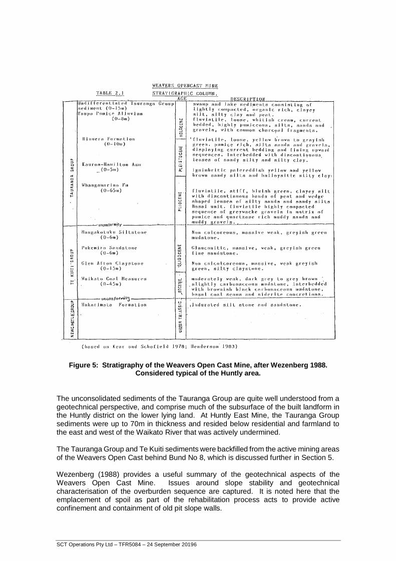
Figure 1: Stratigraphy of the Weavers Open Cast Mine (after Wezenberg 1988).
3.3 The SCT report notes that:
The unconsolidated sediments of the Tauranga Group are quite well understood from
a geotechnical perspective, and comprise much of the subsurface of the built
landform in the Huntly district on the lower lying land. At Huntly East Mine, the
Tauranga Group sediments were up to 70m in thickness and resided below residential
and farmland to the east and west of the Waikato River that was actively
undermined.

7
The Tauranga Group and Te Kuiti sediments were backfilled from the active mining
areas of the Weavers Open Cast behind Bund No 8, which is discussed further in
Section 5. (These matters are covered in Section 4 of my evidence, below.)
4.0 REHABILITATION DESIGN
4.1 The SCT report notes that Wezenberg (1988) (a Master’s thesis) provides a useful
summary of the geotechnical aspects of the Weavers open cast mine, capturing
issues around slope stability and geotechnical characterisation of the overburden
sequence. This reference notes that the spoil placed as part of the rehabilitation
process acts to provide active confinement and containment of old pit slope walls.
4.2 The subject site was constructed by the placement of mine spoil behind an
engineered earth bund wall that forms the southern wall of Lake Puketirini (called
the No 8 Bund Wall). A summary engineering drawing of this earth bund wall is
reproduced as Figure 2.
4.3 The bund wall was constructed on a designed foundation keyed into basement
material. Fireclay (low hydraulic conductivity) was emplaced upstream to mitigate
piping failure beneath the structure, with vertical sand drains (‘chimney drains’)
employed in the bund to manage pore water pressures.
4.4 Figure 3 below shows an example of the typical bund detail and construction
methodology. A key feature to note in this diagram is the concurrent bund and spoil
emplacement and fill material type – these are the same as the general overburden
sequence typical at Huntly.

8
Figure 2: Engineered Earth Bund Wall (No 8 Bund Wall) designed to retain mine spoil and form southern wall of Lake Puketirini

9
Figure 3: Typical Bund arrangement, construction sequence and fill emplacement (view
looking west). Note “FILL” note on TG sediments and marine tertiary forming spoil.
4.5 Figure 4 below is an overlay of an engineering plan on an aerial photo of the subject
site, and shows the location of the No. 8 bund wall relative to the lake. Note the toe
of the completed No. 8 Bund extending approximately 150m into the southern edge
of the lake.
Figure 4: Pit Extents, No. 8 Bund and Rehabilitation Area
10
4.6 I am aware of anecdotes about the nature of the fill, and that it included very soft
material placed without compaction behind the bunds, in places. I understand that
some of the anecdotes relate to the failure of some bunds during and after
construction.
4.7 On the other hand, there is strong anecdotal evidence post-rehabilitation to indicate
there has been no settlement, subsidence or mass ground movements.
4.8 In Section 6, the SCT report refers to the high level of engineering professionalism
with the mine owners, and notes a very high standard of work in the work conducted
for the Weavers open cast mine. The construction of the retaining bund (No. 8 Bund)
and its design provide confidence that the structure has been designed and built to
be fit for purpose.
4.9 These points are a combination of conflicting rumours, anecdotes, professional
experience and documented evidence. While some may find it difficult to resolve the
discrepancies, it is very clear to me. In my profession, I am data- and fact-driven and
gathering data is the most important step to determine how things actually are on
the ground.
5.0 POINTS OF DISAGREEMENT WITH AND CLARIFICATION OF MATTERS WITHIN
TECHNICAL SPECIALIST REPORT
5.1 There are a number of matters on which I disagree with Mr Warrington and/or points
that require clarification. I address these below, by topic, with reference to relevant
paragraphs in his report.
11
Nature of Fill
5.2 In the first paragraph of Section 5.2 of his report, Mr Warrington infers that the
variability of soil materials at shallow depth is indicative of the coal extraction
methodology, unsystematic deposition and uncontrolled compaction of placed fill
materials. Mr Warrington takes this as evidence that the mine waste (his term)
appears to have been placed ‘as found’ from the mine excavations and stockpiles and
not in a selective and controlled manner. Accordingly, he classifies the material as
‘non-engineered fill’.
5.3 In my opinion, the debris is likely to have a high proportion of materials suitable as
engineering fill. There is undoubtedly some weaker material within this mix but the
presence of the weaker material in the final matrix does not necessarily make it
unstable. Pockets of soft material will have been enclosed by containment structures
constructed from the competent material. These pockets will have likely drained and
been consolidated by the loading of the overlying fill material.
5.4 In Section 5.2, paragraph 2, Mr Warrington infers that refusal of four scala
penetrometer tests at less than 1.0 mbgl is most likely due to the presence of larger
cobbles and boulders within the soil matrix, which is indicative of the random make-
up of the fill materials.
5.5 I agree that the make-up of the fill material will be a mix of strong and weaker
material. However, as stated above this does not preclude the final matrix being a
competent mix. The fill has been placed and subjected to significant pressure for
more than thirty years.
5.6 I acknowledge that some softer ground was tested on the eastern area. Conversely,
we have recently identified some harder ground on the western area. TFR will
undertake further testing of the eastern area which may show variability or may
show a pattern. Regardless of the outcome, as Mr Warrington has noted in his
report, the potential for differential settling that might result can be mitigated by
specific engineering design.

12
Slope Stability
5.7 Mr Warrington notes the following in Section 5.2, paragraph 6:
“The mine waste fill beneath the site will slope northwards into Lake Puketirini. The
thickness of fill has been stated as being from meters [sic] up to tens of metres due to
the depth of quarrying activities that have been undertaken. Consequently, the height
and length of the slope beneath the lake supporting the filled area will be significant.
It is noted in the evidence provided by Craig Smith that the maximum depth of the
lake is 64m. The assessment of the stability of this slope is therefore fundamental to
the safety of any proposed development above.”
5.8 Mr Warrington may not be aware that the undisturbed base of the former coal mine
is benched, as shown in the SCT report, and does not slope to the north as such. The
benching of the floor of the coal seam was engineered to restrict the down-slope
displacement of hard fill over the sloping surface, and is called ‘shear keying’.
Groundwater at Depth
5.9 Section 4.2, para 6 of the technical specialist review notes that it has not been
established whether groundwater is contributing to flows within the surface water
drainage zones and subsidence.
5.10 As noted above, engineered ‘chimneys drains’ were installed as part of the backfill
and rehabilitation process to allow ground water to escape. These are shown in
Figure 2 above.
5.11 I agree that further groundwater investigation is required and this will be carried out
as part of the next phase of geotechnical investigation. It is worth noting that the
surface contouring of part of the land did not allow for surface run-off of stormwater.
This has resulted in water ponding in these areas.

13
Requirement for Additional Investigations
5.12 As noted above, I agree that more work is required and advise that TFR is committed
to undertaking investigations as necessary to address the outstanding areas of
uncertainty. However, I disagree that all the investigations must be completed prior
to rezoning. As Mr Warrington has himself stated, there are engineering solutions
that may be used to address variable ground and reduce the risk of subsidence, as is
the case on any building site.
Site Earthworks
5.13 In Section 5.2, paragraph 8 of his report, Mr Warrington flags that coal clasts, heavy
metal minerals and other contaminants may be present in the fill (or mine waste as
he calls it) and may be released into the environment during earthworks. He notes
that a contaminated site assessment would be required to cover these aspects.
5.14 Whilst I do not disagree with this finding, this matter is not one that has any bearing
on whether or not the land should be rezoned. The overburden or fill material is a
mixture of siltstones and mudstones within the Tauranga and Te Kuiti formations,
and is typical of the rock mass throughout much of the Huntly district. Unlike
metalliferous mine sites, coal mines, particularly those in the Huntly district, do not
contain significant levels of heavy metals although low levels of iron are present in
much of the local lithology.
5.15 As stated above, the TFR development plan is to minimise disturbance to the existing
land.
6.0 RATIONALE FOR PROCEEDING WITH REZONING
6.1 TFR is aware that the history of the Puketirini block as a rehabilitated mine site is
likely to be a red flag that will contribute to Council uncertainty as to whether to
rezone.
6.2 I can assure you that TFR takes the geotechnical matters very seriously, and would
not be pursuing the proposed rezoning without confidence in the investigations and
14
knowledge so far, and the understanding that more work must be undertaken over
an extended timeframe. Preparation for development, including securing consents,
will also take time. Rezoning the land to Residential/Commercial will allow some of
the geotechnical investigations to occur in parallel to preparing for development, and
expedite supply to the housing market.
6.3 TFR has confidence in the design and execution of the rehabilitation works and that
the land is stable. The critical aspects are the bund and drainage and we know these
were properly designed and constructed.
6.4 Mr Warrington and I share the opinion that engineering solutions exist, and can be
implemented to address the findings of further investigations and mitigate any
residual risk.
6.5 We have a high level of confidence that our assumptions are being borne out by
investigations to date and that further work will ultimately support this development.
6.6 Mr Warrington’s review supports the s42A report recommendation to rezone the
Weavers Crossing site to Residential Zone.
7.0 CONCLUSIONS
7.1 To conclude, Council is able to rezone the Puketirini block to a combined Residential
and Commercial Zone as per the revised development plan outlined in TFR’s
evidence.
7.2 TFR will continue to undertake geotechnical investigations and assessments as
required as it advances the development.
7.3 There are no geotechnical reasons not to rezone the Weavers Crossing site to
Residential.
Attachment 1
SCT Report
High Level Review of Geotechnical Aspects
Related to Land Development at Puketirini

SCT Operations Pty Ltd – TFR5084 – 24 September 20191
24th September 2019 Craig Smith Director Terra Firma Resources PO Box 67 Ngaruawahia 3742 New Zealand
TFR5084
Dear Craig HIGH LEVEL REVIEW OF GEOTECHNICAL ASPECTS RELATED TO LAND DEVELOPMENT PUKETIRINI
Thank you for the opportunity to submit the following high level geotechnical review of the proposed land development at the previous Weavers Open Cut mine (Puketirini). Our review is based on extensive local experience related to geotechnical characterisation of the rocks and soils of the Huntly area associated with the Huntly East and Huntly West underground mines. Characterisation of the overburden sediments, including the more recent (geologically) Tauranga Group clays, silts and sands, has been integral to understanding surface ground movements in and about mining areas. Figure 1 outlines a general location plan of the previous Weavers Open Cast mine (Google Earth imagery 2019) rehabilitated by Coal Corp NZ in the early to mid 1990’s, with Lake Puketirini being formed in the northern deep area of the mine and the spoil emplacement area to the south being the proposed residential development area. 1. OBJECTIVES OF REVIEW The objective of this high level study is to provide a geotechnical summary of the site characteristics, particularly relating to the nature of the spoil emplacement and related mine closure, and identify any geotechnical issues and forward work for the proposed residential re-development of the site. 2. DATA
A comprehensive datapack comprising site closure plans, technical drawings and registered mine plans has been provided by Terra Firma in digital format. The plans are technical drawings and registered mine plans from the former State Coal Mines NZ and date typically from the mid 1980’s through to mine closure and rehabilitation in the early 1990’s.

SCT Operations Pty Ltd – TFR5084 – 24 September 20192
Figure 1: General Location Plan of Proposed Land Development - Puketirini
Specific technical drawings relating to the construction of the bund wall (No. 8 Bund) that emplaces the spoil rehabilitation and separates Lake Puketirini from the old workings are also provided. Additionally, the author has a range of district information relating to the geotechnical characteristics of the overburden sediments typical of this site, including work from Kelsey (1980’s) and subsequent specific investigations at the Weavers Open Cast in the late 1980’s from Wezenberg (Masters Thesis). A walk over site inspection was conducted by the author on 27 th February 2019.
SCT Operations Pty Ltd – TFR5084 – 24 September 20193
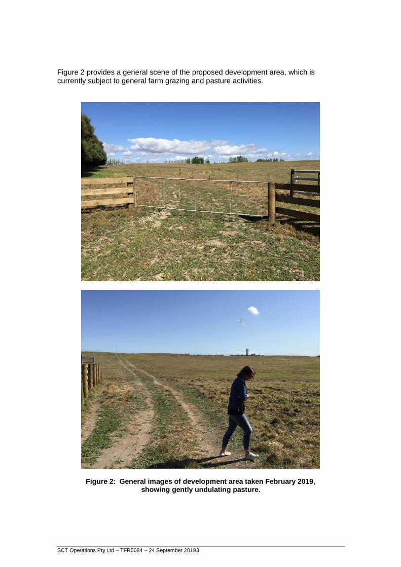
Figure 2 provides a general scene of the proposed development area, which is currently subject to general farm grazing and pasture activities.
Figure 2: General images of development area taken February 2019,
showing gently undulating pasture.

SCT Operations Pty Ltd – TFR5084 – 24 September 20194
3. GENERAL SETTING
The proposed development site forms part of the old Weavers Open Cast coal mine. The open cast mine ran from 1958 until rehabilitation began in 1993 and was operated by State Coal Mines (and latterly Coal Corp NZ/Solid Energy). The site is located immediately west of the township of Huntly, in a broader area of historic open cut coal mining. The main Rotowaro – Huntly coal mine alignment runs to the north of Lake Puketirini. The naturally formed Lake Waahi is to the west and north of the proposed area (as shown in Figure 1). Weavers Open Cast mine targeted coal seams of the Waikato Coal Measures including the Lower Kupa Kupa Seam and overlying Renown Seam. It is noted that the mine plans reviewed here include limited old underground workings of the Taupiri West Mine, that are understood to have been recovered (in part) as part of the open cast workings (this is discussed further later in the report). Figure 3 displays a photograph of open cast mine workings taken from Wezenberg’s thesis and show the in-pit crusher and mine highwall circa 1987.
Figure 3: Weavers Open Cast mine workings circa 1987, after Wezenberg (1988).

SCT Operations Pty Ltd – TFR5084 – 24 September 20195
Figure 4 displays aerial photography of the Weavers Open Cast mine workings at 1985 showing the extensive mine operations across the site and the Huntly township to the immediate east of the operations.
Figure 4: Weavers Open Cast Mine – Workings at 1985 including
details of plans supplied.
The mine rehabilitation comprised the formation of a large retaining bund (No 8 Bund) in the central mining area, behind which successive periods and layers of overburden material from the site were deposited. The active working face continued down-dip to the north (winning coal) until mining and spoil placement was completed. Contractor Doug Hood Mining finalised earthworks associated with mine rehabilitation with the resultant landforms being Lake Puketirini in the north and gently sloping farmland in the south (https://www.doughood.co.nz/projects/open-cast-mining/weavers-opencast-coal-mine-huntly-coal-corporation/). 4. GEOLOGICAL AND GEOTECHNICAL SETTING
The site comprises stratigraphy typical of the Huntly coalfield. The proximity to the Waikato River provides deposition of more recent Tauranga Group sediments that unconformably overly sedimentary rocks of the Te Kuiti Group. The Waikato Coal Measures form the basal unit of the Te Kuiti Group and unconformably overlying basement rocks of the Newcastle Group. Figure 5, taken from Wezenberg’s thesis, summarises the stratigraphic section of the site.
SCT Operations Pty Ltd – TFR5084 – 24 September 20196
Figure 5: Stratigraphy of the Weavers Open Cast Mine, after Wezenberg 1988.
Considered typical of the Huntly area.
The unconsolidated sediments of the Tauranga Group are quite well understood from a geotechnical perspective, and comprise much of the subsurface of the built landform in the Huntly district on the lower lying land. At Huntly East Mine, the Tauranga Group sediments were up to 70m in thickness and resided below residential and farmland to the east and west of the Waikato River that was actively undermined. The Tauranga Group and Te Kuiti sediments were backfilled from the active mining areas of the Weavers Open Cast behind Bund No 8, which is discussed further in Section 5. Wezenberg (1988) provides a useful summary of the geotechnical aspects of the Weavers Open Cast Mine. Issues around slope stability and geotechnical characterisation of the overburden sequence are captured. It is noted here that the emplacement of spoil as part of the rehabilitation process acts to provide active confinement and containment of old pit slope walls.
SCT Operations Pty Ltd – TFR5084 – 24 September 20197
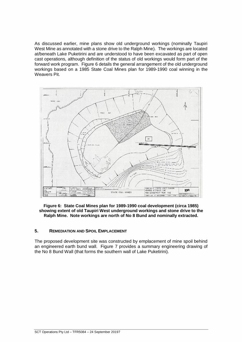
As discussed earlier, mine plans show old underground workings (nominally Taupiri West Mine as annotated with a stone drive to the Ralph Mine). The workings are located at/beneath Lake Puketirini and are understood to have been excavated as part of open cast operations, although definition of the status of old workings would form part of the forward work program. Figure 6 details the general arrangement of the old underground workings based on a 1985 State Coal Mines plan for 1989-1990 coal winning in the Weavers Pit.
Figure 6: State Coal Mines plan for 1989-1990 coal development (circa 1985)
showing extent of old Taupiri West underground workings and stone drive to the Ralph Mine. Note workings are north of No 8 Bund and nominally extracted.
5. REMEDIATION AND SPOIL EMPLACEMENT
The proposed development site was constructed by emplacement of mine spoil behind an engineered earth bund wall. Figure 7 provides a summary engineering drawing of the No 8 Bund Wall (that forms the southern wall of Lake Puketirini).

SCT Operations Pty Ltd – TFR5084 – 24 September 20198
Figure 7: Engineered Earth Bund Wall (No 8) designed to retain mine spoil and form southern wall of Lake Puketirini.
SCT Operations Pty Ltd – TFR5084 – 24 September 20199
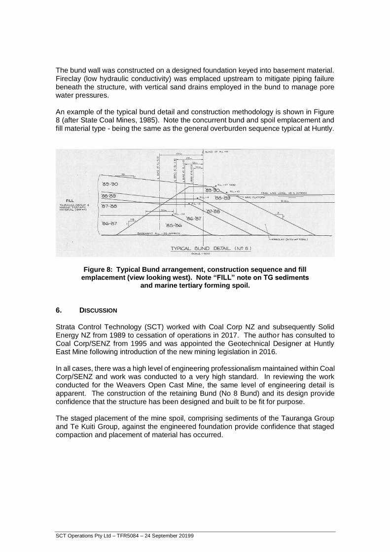
The bund wall was constructed on a designed foundation keyed into basement material. Fireclay (low hydraulic conductivity) was emplaced upstream to mitigate piping failure beneath the structure, with vertical sand drains employed in the bund to manage pore water pressures. An example of the typical bund detail and construction methodology is shown in Figure 8 (after State Coal Mines, 1985). Note the concurrent bund and spoil emplacement and fill material type - being the same as the general overburden sequence typical at Huntly.
Figure 8: Typical Bund arrangement, construction sequence and fill
emplacement (view looking west). Note “FILL” note on TG sediments and marine tertiary forming spoil.
6. DISCUSSION Strata Control Technology (SCT) worked with Coal Corp NZ and subsequently Solid Energy NZ from 1989 to cessation of operations in 2017. The author has consulted to Coal Corp/SENZ from 1995 and was appointed the Geotechnical Designer at Huntly East Mine following introduction of the new mining legislation in 2016. In all cases, there was a high level of engineering professionalism maintained within Coal Corp/SENZ and work was conducted to a very high standard. In reviewing the work conducted for the Weavers Open Cast Mine, the same level of engineering detail is apparent. The construction of the retaining Bund (No 8 Bund) and its design provide confidence that the structure has been designed and built to be fit for purpose. The staged placement of the mine spoil, comprising sediments of the Tauranga Group and Te Kuiti Group, against the engineered foundation provide confidence that staged compaction and placement of material has occurred.

SCT Operations Pty Ltd – TFR5084 – 24 September 201910
The materials comprising the mine spoil are the same as those encountered beneath most of the Huntly area. The intervening years from emplacement, nominally from 1993 to 2019, some 26 years, would be expected to provide for the majority of ground consolidation (under self weight loading and pore pressure redistribution) to have taken place. For this high level review, no fatal flaws have been identified as to why the land would not be considered suitable (from a geotechnical perspective) for further assessment and development as residential land. Attendant issues with site specific soil types (that are endemic to the area) would form part of individual site investigations studies to ensure proper foundation design and construction. Areas of further work are outlined below. 7. FORWARD WORK A review of available cadastral survey data, and other terrestrial based survey data, should be conducted to assist in developing a settlement history for the site. As noted in Section 6, the majority of spoil settlement would be expected to have occurred over the 26 year period. General site investigations relating to the sub-surface properties of the material would be considered appropriate and consistent with industry practice. This may include such things as static/dynamic cone pentrometer tests and short investigation boreholes. Confirmation of the groundwater piezometric surfaces within the area would be recommended. A lidar survey of the site would assist in confirming detailed slope topography, areas of potential settlement/movement and domain mapping future development based on slope, soil types and drainage. If you have any queries or require further clarification please don’t hesitate to contact me. Yours sincerely
Stuart MacGregor Principal Geotechnical Engineer MAusIMM, MEngAus. Managing Director

Attachment 2
Geological Cross Section

Geological cross section parallel to Highwall of Weavers Opencast Mine