Embed Size (px)
Citation preview
1
Statement of reasons for decision 31 January 2019
Channel 9 Willoughby – Modification of Concept Approval MP 10_0198 MOD 2
1. INTRODUCTION 1. On 1 November 2018, the NSW Independent Planning Commission (Commission)
received from the NSW Department of Planning and Environment (Department) a modification application (Application) from Euro Properties and Lotus Property Fund No.8 (Proponent) to amend the existing Concept Approval for a residential development, including small scale non-residential uses (Project), at 6-30 Artarmon Road, Willoughby (Site).
2. As the project is a transitional Part 3A project under clause 2 of Schedule 2 of the
Environmental Planning and Assessment (Savings, Transitional and Other Provisions) Regulation 2017 (Transitional Regulation), and the Commission is the consent authority in respect of such transitional Part 3A projects under the Minister for Planning’s delegation of that function to the former Planning Assessment Commission (PAC) by instrument of delegation dated 14 September 2011. The Commission is to be taken to be the same legal entity as the PAC, pursuant to clause 7 of the Transitional Regulation.
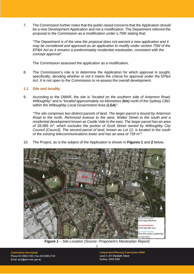
3. The ability to modify transitional Part 3A projects under section 75W (s75W) of the
Environmental Planning and Assessment Act 1979 (EP&A Act) is being discontinued, however as the request for this modification was made before 1 March 2018, the provisions of Schedule 2 continue to apply.
4. Under the Minister’s delegation dated 14 September 2011 the Commission is the
consent authority in respect to the Application because: • the Project constitutes a development of a kind declared by an environmental
planning instrument as development for which a public authority (other than a Council) is the consent authority;
• the Department received more than 25 submissions from the public objecting to the MOD 2 Application; and
• Willoughby Council objected to the MOD 2 Application.
5. Professor Mary O’Kane AC, Chair of the Commission, nominated Dianne Leeson (Chair), John Hann, and Russell Miller AM to constitute the Commission determining the Application.
6. The Commission notes that the public raised concerns around the number of existing modifications currently being considered by the Department (Modifications 1 and 3). Whilst the Commission understands the community’s concerns regarding the issue of multiple modifications under consideration it is to be acknowledged that the current planning framework under the EP&A Act affords the Proponent this right and it is not a relevant matter for consideration by the Commission in relation to its determination of this Application.
2
7. The Commission further notes that the public raised concerns that the Application should be a new Development Application and not a modification. The Department referred the proposal to the Commission as a modification under s.75W stating that:
“The Department is of the view the proposal does not warrant a new application and it may be considered and approved as an application to modify under section 75W of the EP&A Act as it remains a predominately residential masterplan, consistent with the concept approval”.
The Commission assessed the application as a modification.
8. The Commission’s role is to determine the Application for which approval is sought,
specifically, deciding whether or not it meets the criteria for approval under the EP&A Act. It is not open to the Commission to re-assess the overall development.
1.1 Site and locality 9. According to the DMAR, the site is “located on the southern side of Artarmon Road,
Willoughby” and is “located approximately six kilometres (km) north of the Sydney CBD, within the Willoughby Local Government Area (LGA)”. “The site comprises two distinct parcels of land. The larger parcel is bound by Artarmon Road to the north, Richmond Avenue to the west, Walter Street to the south and a residential development known as Castle Vale to the east. The larger parcel has an area of 28,985 m2, which excludes the portion of Scott Street owned by Willoughby City Council (Council). The second parcel of land, known as Lot 12, is located to the south of the existing telecommunications tower and has an area of 739 m2”.
10. The Project, as is the subject of the Application is shown in Figures 1 and 2 below.
Figure 1 – Site Location (Source: Proponent’s Masterplan Report)

3
Figure 2 – Aerial view of Site (Source: Proponent’s Masterplan Report)
11. The DMAR stated that:
“While the Proponent has identified Lot 12 as being part of the site, the Department has excluded it for the purposes of calculating floor space ratio (FSR) and open space, as Lot 12 is physically separated from the main parcel of land and no development is proposed on the lot”.
12. A site inspection was conducted by the Commission on 27 November 2018 (see section
3.4) to gain an understanding of the physical attributes of the Project. From this inspection the Commission noted that the site has not commenced re-development and that the locality consisted predominately of single and two storey detached residential dwellings with some medium density residential units also present.
13. The Commission noted that the topography of the site undulated significantly, however it predominately slopes downhill along the Artarmon Road frontage from west to east, and along the Richmond Avenue frontage from north to south. The Commission further notes that the frontage to Scott Street dips significantly to the middle of the site, with the northern and southern section’s being notably higher in elevation, and that established houses on the northern side of Artarmon Road are at a significantly higher elevation than the site.
14. The DMAR provides a detailed description of the site within section 1.2 and of the surrounding development in section 1.3.

4
1.2 Background to Development Application 15. The DMAR and the Proponent’s (s75W) Environmental Assessment Report
(Proponent’s EAR) provide a historical summary of Concept Approval for the site. From these sources the Commission understands the history of the Project to be:
• Concept Plan approval granted by the PAC on 5 March 2014; • PAC directed by the Land and Environment Court (LEC) to approve an amended
concept plan. Amended concept plan approved by the PAC on 23 December 2014;
• Modification 1 – lodged 2 May 2016 with the Department and not currently determined;
• Modification 2 – lodged 7 April 2017 (the Application currently before the Commission and the subject of this report); and
• Modification 3 – lodged 12 September 2017 with the Department and not currently determined.
16. A more detailed description of the original approvals and subsequent modification is
contained within the DMAR in section 1.4 and the EAR in section 3. 1.3 Summary of Development Application
17. According to the DMAR the Proponent submitted its Application on 7 April 2017. The
Application was accepted by the Department on 15 November 2017 under section 75W of the EP&A Act to modify the concept approval.
18. Based on the information before it and as stated by the DMAR (section 2.1) the Commission understands that the Application before it for determination includes reconfiguring the layout, including the location, heights and types of proposed buildings (Figure 3) and:
• excluding from the site the portion of Scott Street owned by Council; • amending the internal layout of the Project to change the location of open space; • increasing the number of building envelopes from 7 to 9 and increasing the
maximum number of dwellings from 400 to 460; • increasing the maximum gross floor area from 37,136m2 to 43,907m2; • amending building envelope heights (while maintaining the maximum approved
envelope height of RL 105.4); and • including child care facility as a permitted use.
19. The Commission notes that on page 9 and 10 of the DMAR a comparison table is
provided for the Application which described the existing Concept Approval (as approved by the LEC), the Application (as originally lodged with the Department and exhibited), and the Application (as amended and as now considered in this report). This table is reproduced in Appendix 1.
1.4 Stated need for modification 20. The Applicant’s EAR stated that the original approval resulted “in a design outcome…
that is reflective of a series of compromises that did not provide optimal design or open space outcomes for the Site”.

5
2. THE DEPARTMENT’S CONSIDERATION OF THE APPLICATION 2.1 Key steps in Department’s consideration of the Development Application 21. The DMAR stated that the Application was accepted by the Department on 15 November
2017, and was placed on public exhibition for 30 days, commencing on 16 November 2017, and concluding on 15 December 2017. During the exhibition period the Department received 456 submissions which included three from agencies, one from Council and 435 from members of the public which included 423 objections.
22. A breakdown of the key issues raised, and the number of submissions during exhibition
as summarised in the DMAR is provided in Table 1. The Commission notes that these submissions relate to the Application that was originally submitted to the Department and not as subsequently amended.
Issue % of Submissions
Traffic, parking, public transport impacts 82%
Scale / height of development 79%
Density (dwelling numbers) 74%
Planning process (new scheme vs modification) 65%
Reduced public benefits 50%
Inferior design to approved concept plan 44%
Poor community consultation 38%
Social infrastructure (education facilities) 29%
Environment / tree clearing concerns <15%
Privacy impacts <15%
Retention of the existing radio tower <15%
Concerns over introduction of childcare facilities <15%
Reduction of non-residential floor space <15%
Insufficient on-site car parking spaces <15%
Exhibition period prior to the Christmas holiday period <15%
Overshadowing <15%
Table 1 – Breakdown of submissions (Source: DMAR) 23. The DMAR further stated that the Proponent’s Response to Submissions (RtS) reduced
the scale of the modification, was made available on its website and notified to agencies and the community groups. The Department received three submissions from agencies, one from Council and no further public submissions. Council has maintained its objection to the Application, however no agency objected to the Application. The nature of agency and Council comments is discussed in greater detail within section 5.4 of the DMAR.

6
24. The Commission notes that the DMAR confirmed that the RtS was made publicly available on its website and but was not formally re-exhibited.
25. The Department has prepared an assessment report (referred to as the DMAR) in
respect to the Application. 2.2 The Department’s assessment report
26. The DMAR, identified the following as the key impacts associated with this Application:
• density; • built form; • public domain; • traffic, parking and public transport; • residential amenity; and • developer contributions.
27. The DMAR concluded that:
“The proposed built form in conjunction with the associated open spaces, is considered to result in an improvement to the approval.” “…the site is large enough to support the scale of the development proposed…” “.. the site has sufficient capacity to accommodate the increase in housing without causing adverse impacts on the immediate surrounding area.” “The Department concludes that the impacts of the proposal are acceptable and can be appropriately mitigated through the implementation of the recommended conditions.”
3. THE COMMISSION’S MEETINGS AND SITE VISIT 3.1 Meeting with the Department 28. On 13 November 2018, the Department met with the Commission. A copy of the meeting
agenda is available on the Commission’s website, and a copy of the meeting transcript was made available on the Commission’s website on 21 November 2018.
3.2 Meeting with the Proponent 29. On 13 November 2018, the Proponent met with the Commission. A copy of the meeting
agenda is available on the Commission’s website, and a copy of the meeting transcript was made available on the Commission’s website on 21 November 2018.
3.3 Meeting with Willoughby City Council 30. On 13 November 2018, the Council met with the Commission. A copy of the meeting
agenda is available on the Commission’s website, and a copy of the meeting transcript was made available on the Commission’s website on 21 November 2018.

7
3.4 Site inspection 31. On 27 November 2018, the Commission conducted an inspection of the site and visited
the locality. During the site inspection the Proponent escorted the Commission within the site. The Commission, independent from the Proponent then conducted a further site inspection on the day covering the locality around the site including along Richmond Avenue, Artarmon Road, Scott Street and Walter Street. Site inspection notes were made available on the Commission’s website on 17 December 2018.
3.5 Public meeting 32. To hear the community’s views on the proposal, the Commission held a public meeting
at Club Willoughby, 26 Crabbes Avenue, Willoughby on 27 November 2018. A list of the 13 speakers that presented to the Commission was provided on the Commission’s website. A transcript of the public meeting has been made available on the Commission’s website. A copy of the material tendered at the public meeting was also available on the Commission’s website. All persons were offered the opportunity to provide written comments to the Commission within 7 days after the public meeting. A summary of issues raised in written submissions and by speakers is outlined below in paragraph 30.
33. In summary, the main issues of concern included:
• additional density; • traffic impacts and distance from transport and services; • re-location and accessibility of open space; • urban design; and • lack of community engagement by the Proponent.
4. THE COMMISSION’S CONSIDERATION 4.1 Material considered by the Commission 34. In this determination, the Commission has carefully considered the following material
(material): • S75W Modification Application – 30 October 2017 and all associated documents; • Agency submissions on the s75W Modification Application from:
− Roads and Maritime Services – 6 March 2018; − Sydney Water – undated; and − Heritage Council of NSW – 20 November 2017.
• Willoughby City Council submission on the s75W Modification Application – undated, including: − Traffic Impact Assessment (Modification 2) Review, prepared by ARUP, dated
19 February 2018, Rev A; and − 6-30 Artarmon Rd Willoughby Review Modification 2 – Revised Concept Plan
Review, prepared by Allen Jack + Cotter, dated March 2018. • Response to Submissions – 28 March 2018 and all associated documents; • Agency comments on the Response to Submissions from:
− Transport for NSW – 30 April 2018; − Sydney Water – undated; and − Heritage Council of NSW – undated;
• Willoughby City Council comments to the Response to Submissions – 6 June 2018; • Proponent Additional Information – 31 May 2018 and all associated documents;

8
• Proponent Additional Information – 29 August 2018: − Communal Courtyard Open Space Calculation; − Final Amended Plans – 29 August 2018; − Height Diagram; − Open Space Calculation; and − Roof Plan Building Envelope.
• MP10_0198 MOD 2 – Department’s Assessment Report and all associated documents including: − Samsa Consulting Traffic Report; and − Government Architect comments of 23 September 2016 and 22 December
2017. • all submissions made to the Department in respect of the proposed modification
during the public exhibition of the Application; • clarification statement made by the Department of Planning and Environment – not
dated; • Proponent presentation to the Commission on 13 November 2018; • Additional information from Willoughby City Council received 15 November 2018,
including: − IPART submission – 22 December 2016; − HILL PDA Advice – 1 September 2018; and − ‘Synopsis of points from meeting with IPC dated 13 November 2018’ –
undated. • Additional information from Willoughby City Council received 18 December 2018,
including: − Council Report to Ordinary Council Meeting– 26 November 2018; and − Ordinary Council Meeting Resolution – 26 November 2018.
• Proponent presentation to the public meeting in 27 November 2018; • all oral comments made to the Commission at the public meeting held on 27
November 2018 and all written comments received to the Commission up until 5 December 2018;
• the visual observations made at the site and locality inspection on 27 November 2018;
• Additional comments from the Proponent dated 29 November 2018, including: − Letter from Willoughby Council dated 15 November 2016; and − Letter from Platform Project Services to Willoughby City Council dated 18
January 2018. • the public interest; and • matters for consideration specified by the EP&A Act, including Section 75W.
4.2 Built Form Public considerations 35. The Commission heard concerns from speakers at the public meeting and received
written comments regarding the impacts of the Application due to the proposed built form. It was said for instance at the public meeting, that these concerns included: • additional building heights and density:
− the removal of the park from the corner of Artarmon Road and Richmond Avenue in the modified scheme reduces the building setback and further reduces the transition established in the approved scheme; and
9
− the increase in storeys on Richmond Avenue will increase the number of dwellings sited directly on this street and result in a greater loss and impact of amenity to existing Richmond Road residents.
• overshadowing: − whether or not the Modification would improve overshadowing was irrelevant;
and − the key issues being the suitability of the site to house more residents.
• additional traffic impacts: − increasing dwelling numbers by 15% could only add to the strain on the local
streets already under more pressure; and − the road layout in MOD2 will see more properties in Richmond Avenue
affected by increased traffic flow and the problems that brings, such as noise and nuisance from vehicle lights.
• reduction in setbacks to Artarmon Road and re-location of open space: − the removal of the park from the corner of Artarmon Road and Richmond
Avenue in the modified scheme reduces the building setback; and − it further reduces the transition established in the approved scheme and
relocates open space to within the site reducing its value and accessibility to the surrounding community.
Council considerations 36. The Commission notes that Council raised concerns regarding the built form of the
Application which included: • Height, location and set-back:
− height, design and lack of set-back for the proposed buildings along the Artarmon Road frontage;
− poor design interface with the neighbouring residential properties on Richmond Avenue and Artarmon Road; and
− the seven-storey development proposed immediately adjacent to Scott Street, being in very close proximity to the street, without reasonable setback and not very characteristic of the area.
• Design Excellence: – design excellence is already a requirement of the existing concept approval
and not a justification for an increase in dwellings, floor space ratio and building height; and
− the concept proposed is an improvement over the approved scheme but could be improved by reducing density and other design changes.
• Public Benefit: − The stated additional public benefits are not what council would consider or
accept as a significant public benefit and are required either to offset project generated impacts or are below Council’s agreed position for contributions.
• Governance: − Concerns that intensification of the site departing from the approval by the
LEC and PAC will have ramifications for public confidence in the overall planning process.

10
Proponent’s consideration 37. The proponent undertook an assessment of the Application’s built form in both its EAR
and RtS. Illustration of the approved and proposed site layout is included as Figure 3. 38. In relation to building envelopes, the EAR stated that:
“Building envelopes provided… are maximum envelopes which set the horizontal and vertical parameters for future buildings are not the final detailed building envelopes.” “The envelopes therefore do not represent the final built form outcome for the site, and will be subject to further assessment as part of future DAs.” “The proposed building envelopes have been designed and tested to ensure an appropriate interface between the: • low-scale buildings to the Artarmon Road and Richmond Avenue street edges to
provide a fine-grain and low-scale transition to surrounding residential areas; • a central core of north-south orientated mid-rise buildings that are generally
shielded by the perimeter buildings and minimise their visual impact through orientation; and
• three taller elements located centrally within the site, with smaller floorplates to minimise visual impacts and overshadowing.”
39. In relation to overshadowing, the EAR stated that:
“The amended master plan provides for a net reduction in overshadowing impacts in comparison to the approved concept plan…” “all neighbouring residences on Walter Street achieve compliance with the applicable solar access provisions of the Willoughby Development Control Plan 2012, except where neighbouring dwellings cannot comply due to existing topographically conditions. In the Castle Vale residential complex to the east, all affected residential flat buildings comply with the design criteria of the Apartment Design Guide [ADG] and there is a net improvement in solar access compliance.”

11
Figure 3 – Layout Comparison - Approved Layout (top) – Proposed Layout (bottom)
12
40. In relation to overshadowing, the RtS stated that: “Only the residential apartment building approved at 15-17 Walter Street is impacted by additional overshadowing from the CHROFI master plan compared to the existing overshadowing of this site…” “Solar access diagrams submitted with this Development Application indicated that 22 out of the 23 apartments within the approved development receives the minimum of two hours of direct sunlight in accordance with the ADG.” “…modelling by CHROFI demonstrates that when the amended CHROFI master plan (particularly Building J) is taken into account, there is some additional overshadowing of apartments located at the lower levels of the north-western corner of this building however all affected apartments continue to achieve a minimum of two hours of direct sunlight in accordance with the ADG. The approved development would continue to achieve well in excess of the solar access required under the ADG (96% of apartments compared to the required 70%).”
Department’s assessment 41. The DMAR stated that:
“…the key assessment issues associated with built form are: • envelope height; • overshadowing; • public domain interface.
42. In relation to envelope height the DMAR stated that:
“The proposal as exhibited sought to increase the maximum envelope height for Buildings D and E to 11 and 12 storeys (RL 113.3 and RL 116.2) respectively, which would exceed the maximum height of eight storeys and RL 105.4 established under the concept approval.” “… the Department agrees with the concerns raised in the public submissions and by Council about his additional height, and required the Proponent to reduce the height of Buildings D and E to be consistent with the maximum height established by the PAC and LEC”. “The Department considers the proposed revised maximum envelope height its acceptable as it: • maintains the maximum height (of RL 105.4) established by the concept approval • ensures that the taller elements of the proposal are located centrally, with no
detrimental visual impact when viewed from the surrounding area • reduces overshadowing of adjoining dwellings.”
43. In relation to site edge envelope height the DMAR stated that: “The proposal seeks to alter how the development presents along the site edges in terms of building envelope height. The concept approval included three storey envelopes adjacent to the southern boundary and Richmond Avenue, with publicly accessible open space and a four storey residential flat building adjacent to Artarmon Road.”

13
“The proposal seeks to provide a more uniform four storey built form along Richmond Avenue and Artarmon Road, with a built form of up to six storeys along the southern boundary”. “The Department supports the proposed building heights along the site edges/ street frontages, as: • the proposal responds appropriately to the surrounding context, noting the generally
arrangement of smaller, more articulate built forms on the site edge providing a scale transition to the detached dwellings
• the proposed four storey envelopes along Artarmon Road and Richmond Avenue are set back on the upper floor, which also assists in the scale transition to the lower scale buildings to the north and west of the site and reduces the visual appearance of the buildings when viewed from the surrounding public domain
• the amended layout relocates the open space from the corner of Artarmon Road/ Richmond Avenue centrally within the site (creating a view corridor from Edward Street) and providing an opportunity for a new four storey building on this corner that reinstates the rhythm of buildings that respond to the street layout
• the proposal reduces overshadowing of adjoining properties…” 44. In relation to envelope height the DMAR concluded that:
“…the proposal appropriately responds to the constraints of the site and will not result in any adverse impacts on the adjoining dwellings or surrounding areas.” “…the proposed envelope heights on the site edge appropriately respond to the surrounding low scale character of the central buildings retain the maximum height established under the concept approval. The proposal also improves the transition between taller central buildings and the surrounding development. The Department therefore supports the proposed envelope heights.
45. In relation to overshadowing to Walter Street the DMAR stated that:
“… five existing dwellings along Walter Street do not receive three hours of solar access to their principal open space between 9 am and 3 pm, midwinter, under the concept approval. However, the Department notes solar access to these dwellings improve under the proposal, with only four dwellings receiving less than three hours of solar access to their principal open space during this time.” “… the concept approval affects four dwellings within the Castle Vale development to the extent that they do not achieve the minimum two hours of solar access between 9 am and 3 pm midwinter. However, the revised proposal reduces this impact, such that only one dwelling no longer receives two hours of solar access.”
46. DMAR concluded that:
“the proposal results in an overall improvement of solar access to existing dwellings along Walter Street, when compared to the concept approval and supports the modification in this regard.” “the proposal will maintain acceptable level of solar access to the approved development along Walter Street, having regard to solar access criteria within the ADG.”
14
47. DMAR concluded with regard to overshadowing of the Castle Vale development that: “the proposal results in improved solar access to adjoining development when compared to the concept approval”.
48. The NSW Government Architect (NSWGA) was consulted by the Department during their assessment of the Project. The NSWGA stated that: “The building massing appears to respond appropriately to the surrounding context with particular note to: - The general massing arrangement of smaller, more broken up and deeply articulated
building forms along both Artarmon Road and Richmond Avenue that provide a transition in scale to detached houses along both street frontages.”
“The generic section of the ‘sunken’ design and imagery provided in the Concept Plan documentation is unconventional; although not necessarily problematic if well designed.”
49. The Commission notes that the DMAR contains a detailed analysis of the Application’s overshadowing impact on approved developments within Walter Street. This is referenced as Table 11 on page 31 of the DMAR.
Commission’s findings
50. The Commission has considered the Future Environmental Assessment Requirements (FEARs) which have been included within the development consent which reinforce future development expectations of the site.
51. The Commission notes that the final built form of the Project will be subject to future
assessment by the relevant consent authority under the relevant statutory controls.
52. Based on the Material, and acknowledging the concerns raised by the public and Council, as referenced in paragraphs 35 and 36, the Commission nevertheless finds that the proposal to amend the built form of the Project is acceptable because: • the proposed increase in height from 8 to 9 stories is for 2 buildings located in the
centre of the site. They are within the Concept Plan height limit of RL105.4. The change in RL level along Artarmon Road from 90.30 to 94.80 and along Richmond Avenue from 92.20 to 94.80, provides a transition in the context of the surrounding urban environment;
• the setbacks of the top floors of the buildings to Richmond Avenue, Artarmon Road and the public domain provide further articulation and transition from the low scale surrounding properties, notwithstanding the loss of the public open space at the corner of Artarmon Road and Richmond Avenue;
• there is an improvement to potential overshadowing impacts generated by the development;
• the location of the building envelopes is an improvement on the overall concept, provided the proposed public spaces are protected as proposed by the Commission;
• does not create any unreasonable additional impacts within the locality; and • the Commission accepts the analysis and conclusions as referenced within
paragraphs 44, 46 and 47.
15
4.3 Density Public and Council considerations 53. The Commission heard concerns from Council, speakers at the public meeting, and
received written comments regarding the impacts of the Application related to the increase in density. These concerns included: • development is too dense for the site; and • increase in dwelling numbers are too high for the site above what is approved and
should not exceed 400 dwellings. Proponent’s consideration 54. The Proponent undertook an assessment of the Application’s density in both its EAR
and RtS. 55. The EAR stated that:
...the consequential increase in the maximum Gross Floor Area (GFA) proposed does not give rise to any significant adverse environmental impacts, and in fact supports a number of initiatives which reduce the impacts of the Concept Plan. …the proposed increase to density development is compatible with the Site’s location and the additional density does not, in and of itself, give rise to any additional environmental impacts”.
56. The Commission notes that the EAR stated that dwelling numbers would increase from 400 to 495. The Proponent in its letter to the Department dated 20 August 2018 amended the Application to adjust total dwelling numbers to 460. It is the Commission’s understanding that the reduction in dwelling numbers is in response to the reduction in buildings heights across the site.
Department’s assessment 57. The DMAR stated that:
“Density is a sensitive issue in the local community, being a key issue raised by Council and the public in the original concept plan, MOD 1 and current proposal. The concept approval set a maximum GFA of 37,136m² and a maximum of 400 dwellings within seven building envelopes. The proposal seeks to increase the number of building envelopes and building heights, to accommodate additional 6,771m² of GFA and up to an additional 60 dwellings.” “The Department considers density is ultimately informed by the appropriateness of the built form, traffic generation and demand on existing/ future infrastructure. Noting the site’s location within a predominantly low scale area (with a strong one and two storey character), the Department considers any increase in density must be sensitive to this character.” “The Department considers an increase in density acceptable for this site, as: • building heights are no greater than the maximum height established by the
approval

16
• the built form along the site edges create a reasonable transition with the surrounding low scale character
• overshadowing of adjoining proposed is improved • traffic generation remains acceptable and has no material impact on the road
network • the proposal includes additional public benefits via a proposed voluntary planning
agreement (VPA)”
58. The DMAR concluded that: “The Department concludes the proposal does not unreasonably impact on the surrounding area, despite an increase in density, and results in improve public benefits.”
Commission’s findings 59. The Commission has considered the Future Environmental Assessment Requirements
(FEARs) which have been included within the development consent which reinforce future development expectations of the site.
60. The Commission notes that the final density of the Project will be subject to future
assessment by the relevant consent authority under the relevant statutory controls.
61. Based on the Material, and acknowledging the concerns raised by the public and Council, as referenced in paragraphs 53, the Commission nevertheless finds that the proposal to amend the density of the Project is acceptable because: • the Application improves the overall built form impacts of the Project, both within the
site and on external receivers, as discussed in section 5.1.1; • the proposed additional 60 dwellings makes a marginal difference only in terms of
overall density. While the community raised concern about an Application that increases density above the negotiated 400 units, the Commission is obliged to deal with the Application in accordance with the Act;
• the proposed building footprints and open spaces provide a more open, accessible site, as discussed in section 5.1.3;
• the Application does not materially change existing Project traffic impacts and intersection performance remain acceptable as discussed in section 5.1.4; and
• the Commission accepts the analysis and conclusions as referenced within paragraph 58.
4.3 Open Space Public consideration 62. The Commission heard concerns from speakers at the public meeting and received
written comments regarding changes to the public domain and open space associated with the Application. The Commission was informed at the public meeting, for instance that: • the relocation of the public park significantly reduces its impact from being highly
visible and accessible from Artarmon Road to an almost private park for the Project’s residents. It will likely enjoy fewer visits from occasional or casual users and the community generally;

17
• the relocation of the originally proposed park from the Artarmon Road frontage to the centre and rear of the property will act as a disincentive to use it by those living outside the Project site; and
• open green space has increased by 900 square metres, but total open space has reduced by 344 square metres. The increase in open green space has been largely achieved through a reduction in internal roads.
Council considerations 63. The Commission notes that Council considered the amended design to be conceptually
a positive outcome, but stated that: • the private benefit of the increase in site density and yield is not supported by a
proportionally equivalent public benefit regarding access to open space; and • all publicly accessible land on the site being owned by the Proponent and
maintained by the development.
Proponent’s consideration 64. The Proponent undertook an assessment of the public domain works and open space
in both its EAR and the RtS. 65. The EAR stated that:
“Under the proposed modification, public open space on the Site would increase by 164%, resulting in an additional 5,146m² of publicly accessible open space. This increase represents a significant public benefit associated with the modification, which is achieved by providing narrower building envelopes and a rationalised internal road layout.”
“the additional dwellings proposed under this amendment will be critical in ensuring the initial feasibility and ongoing viability of maintaining this public space to a high standard. Council took a strong stance against public ownership of the publicly accessible areas of the Site during the assessment of the previous Concept Plan, meaning that the ongoing cost of maintaining this additional space will fall onto the owners of new dwellings under a Community Title arrangement. Simply increasing the open space to be maintained without a commensurate increase in dwellings would be financially unsustainable and would impact on housing affordability and the long-term quality of these spaces.”
66. The RtS stated that:
“the calculation of public open space and communal open space has been revised to allocate the Village Courtyard (Tree 32 surrounds) as communal open space rather than public open space. This reflects that this space is surrounded on four sides by residential apartment buildings and is not immediately perceptible from Artarmon Road as being an accessible public space. …the re-allocation of the Village Courtyard area from public to communal open space for the purpose of site calculations, the amended master plan still provides for a significant increase in the area of publicly accessible open space compared to the existing Concept Plan Approval (134% increase compared to current approval)”.

18
Department’s assessment 67. The DMAR stated that:
“The proposal seeks a new configuration of the site that changes the size and layout of the open spaces. Open space within the site is characterised as either publicly accessible or communal (available to future residents). All publicly accessible open space includes legal arrangements to ensure the space remains publicly accessible, while access to communal open space will be controlled by the future owners corporation.” “The original concept approval provided 6,733m² of open space in the form of a 3,178m² publicly accessible park adjacent to Artarmon Road and 3,555m² of communal open space. The proposal seeks to provide 7,640m² of open space in the form of 6,385m² of publicly open spaces known as the Village Green, Village Lawn and Village Square, and 1,255m² of communal open space”. “the proposal increases the total amount of open space by 907m². the new layout doubles the amount of publicly accessible open space available under the concept approval and improves visual links and accessibility to the public.”
68. The DMAR concluded that: “the proposal represents a significant improvement in open space and therefore supports the proposal in this regard.”
69. The NSWGA stated that:
“One of the most significant improvements in the concept plan is the structure planning of the site and the location and amount of public domain provided. Under the Concept Plan the system of streets and open spaces is indicated as part of the public domain and is in public ownership.”
Commission’s findings 70. The Commission has considered the Future Environmental Assessment Requirements
(FEARs) which have been included within the development consent which reinforce future development expectations of the site.
71. The Commission notes that the final open space design of the Project will be subject to
future assessment by the relevant consent authority under the relevant statutory controls.
72. The Commission accepts that the Modification provides increased usable open space, as calculated by the Department in paragraphs 67 and 69, and subject to conditions to ensure that the open space designated as ‘Village Green’ is open and publicly accessible. It is proposed to include conditions for that purpose. The Commission also accepts that the relocated public park will not be as prominent and accessible as if it were on Artarmon Road but sees benefits in it not being on a busy road. Activation of the park is important, and the Commission has applied conditions for that purpose.

19
73. Based on the Material, and acknowledging the concerns raised by the public and
Council, as referenced in paragraphs 62 and 63, the Commission nevertheless finds that the proposal to amend the open space of the Project is acceptable because: • the reduction in privately accessible communal open space has enabled
reallocation to publicly accessible open space to the following extent: − original concept approval provided 6,733m² of open space - proposal seeks
to provide 7,640m² of open space; − original concept approval provided 3,178m² publicly accessible open space –
proposal seeks to provide 6,385m² of publicly accessible open spaces; and − original concept approval provided 3,555m² of communal open space -
proposal seeks to provide 1,255m² of communal open space; • the location and design of the open space areas has the potential to enhance public
accessibility with appropriate activation; • improved opportunity for activation of public open space by promoting the
incorporation of non-residential use on the ground plane of Buildings D and E through amended FEARs; and
• the Commission accepts the analysis and conclusions as referenced within paragraph 68.
4.4 Traffic and Parking Public consideration 74. The Commission heard concerns from speakers at the public meeting and received
written comments regarding impacts related to traffic and parking. For instance, it was said for instance at the public meeting, that: • the Channel 9 site is a suburban site that has little mass transport or commercial
amenities within walking distance. • residents in the area are highly dependent on car transport to access to shops,
health services and amenities and: − local bus services are already exceeding capacity; and − Artarmon train station is at the limits of walking distance.
• local roads are already struggling with existing traffic and the locality is car dependant. The Department’s conclusion that ‘traffic generation’ is acceptable, was highly debatable, and that the Department’s assessment report relies upon a traffic assessment that lacks appropriate rigour. It is based on out-of-date traffic volumes.
Council consideration 75. The Commission notes that Council raised concerns regarding the traffic and parking
impacts of the Application which included: • the design of proposed roundabouts and internal road system; • loss of on-street car parking; • rate of off-street car parking consistent with the Willoughby Development Control
Plan but raised concerns with the location of visitor car parking; and • concerns relating to the methodology of traffic modelling.

20
Proponent’s consideration 76. The Proponent undertook a Transport Impact Assessment (TIA), prepared by McLaren
Traffic Engineering, dated 30 March 2017. In relation to intersection performance, the TIA stated: “the intersection performance of Artarmon Road / Willoughby Road operates at LoS [Level of Service] “B” & “C”, which is an acceptable level of performance.”
Department’s assessment 77. In relation to traffic impacts DMAR stated that:
“Council raised concerns over traffic impacts and as part of its submission to MOD 1 and the proposal, engaged ARUP to provide a traffic assessment, which concluded: • the Willoughby Road/ Artarmon Road/ Small Street intersection would operate at
an unsatisfactory level and is required to be upgrade • the Scott Street/ Artarmon Road roundabout is not appropriate given the gradient
of Artarmon Road and departs with the Austroads Guide to Road Design • inadequate internal circulation space within the new road network is provided for
waste and large removalist vehicles • a portion of car parking within the new internal road should be designated as
resident parking only to offset the loss of existing street parking.” 78. The DMAR further stated that:
“the Department engaged Samsa Consulting to undertake an independent traffic analysis of the proposal and provide advice on the conclusions of the ARUP and McLaren assessments, including: • the impacts on the Willoughby Road/ Artarmon Road/ Small Street intersection; • the proposed Artarmon Road/ Scott Street roundabout; • internal sweep paths; • the appropriateness of any monetary contribution towards future intersection
works.”
“The traffic analysis provided by Samsa Consulting agrees with McLaren’s traffic analysis, in that the traffic generated by the proposal would not impact on the performance of the Willoughby Road/ Artarmon Road/ Small Street intersection to the extent that warrants an upgrade. The review concluded the operation of the intersection following the development would be mostly affected by background traffic volumes along the surrounding road network rather than the proposal itself. “Samsa Consulting also noted the ARUP traffic assessment included traffic generation from future potential development in the surrounding area. Samsa Consulting disagreed that all potential future development should be used in the traffic assessment due to those developments being subject to their own approval process and considering them for the subject proposal would over-estimate the traffic generation in the area.” “that neither RMS or TfNSW raised any concerns with the operation of the subject intersection.”

21
79. The DMAR noted that:
“the McLaren traffic assessment was based on 510 dwellings, and not the lesser traffic generation resulting from the reduced 460 dwellings now proposed.”
80. The DMAR further noted that: “the retention of Scott Street and the provision of a raised pedestrian crossing on Artarmon Road, west of Edward Street (FEAR 17), provides sufficient sight distances and traffic speeds along Artarmon Road to permit safe right hand turn movements into and from the Scott Street without the need for a roundabout. Therefore, the Department recommends the deletion of FEAR 10 and 11 which restricts Scott Street to left in/ left out only and requires the provision of a roundabout at the intersection of Artarmon Road and Richmond Avenue”.
81. The SAMSA Report stated that:
“It is agreed with the findings of the Arup report that while there will be no net-loss of on-street parking in the area due to the subject proposed development, Artarmon Road residents reliant on parking outside / adjacent to their properties would be impacted by the proposal.”
“…on-street parking internal to the development site should be clearly identified to compensate for loss of parking on Artarmon Road and Richmond Avenue, ie. the number of lost on-street parking spaces should be designated as residents parking only, with effected residents of Artarmon Road (between Edward Street and Willoughby Road) eligible to park in the car spaces near the Artarmon Road access point and effected residents in Richmond Avenue eligible to park in the car spaces near the Richmond Avenue access point.”
82. In relation to car parking the DMAR stated that:
“The Department notes the on-site car parking rates established by the PAC and LEC do not change. The Department remains satisfied the proposal provides sufficient on-site car parking provisions, consistent with Council’s controls, and ultimately provides an additional 14 street car parking spaces compared to the concept approval”.
83. The DMAR concluded that:
“the extent of traffic impacts arising from the proposal is acceptable and does not warrant an upgrade of the intersection.” and that “the proposal will not result in any unreasonable traffic generation or associated impacts on the surrounding road network…”
Commission’s findings 84. The Commission notes that the SAMSA report (page 3) related to the traffic impact of a
slightly higher number of units (495) but the Commission does not see this as materially affecting SAMSA’s advice.
85. The Commission has also considered the Future Environmental Assessment
Requirements (FEARs) which have been included within the development consent which reinforce future development expectations of the site.

22
86. The Commission notes that the final traffic impacts and car parking requirements of the Project will be subject to future assessment by the relevant consent authority under the relevant statutory controls.
87. Based on the Material, and acknowledging the concerns raised by the public and
Council, as referenced in paragraphs 74 and 75, the Commission nevertheless finds that the proposal to amend the traffic and parking of the Project is acceptable because: • the Commission accepts the SAMSA Consulting advice on the methodology for
traffic modelling, • the Commission notes the SAMSA Consulting modelling relates to the impact of an
additional 95 dwellings rather than 60 dwellings as currently proposed; • intersection performance is satisfactory, but may change if the proposed child
centre proceeds. The Commission has included a condition requiring the preparation of a traffic study should a child care facility be proposed;
• off-street car parking requirements do not change from the existing approval; • the Commission has accepted the SAMSA recommendation and applied a condition
of consent to require the implementation of a resident parking scheme along all publicly accessible private roads within the development; and
• the Commission accepts the analysis and conclusions as referenced within paragraph 83.
4.5 Affordable Housing Public and Council comments 88. The Commission heard concerns from Council, speakers at the public meeting, and
received written comments regarding the provision of affordable housing as it was unclear how many affordable housing dwellings would be provided.
Proponent’s consideration 89. The EIS stated that:
“The existing Concept Plan Approval already provides for 4% of gross floor area (in the form of finished dwellings) to be dedicated to Council as affordable rental housing, consistent with Willoughby City Council’s affordable housing principles.” “…the Proponent has committed to a 5% affordable rental housing provision for any additional gross floor area approved as part of this Modification Application. This will provide additional affordable rental housing within the Willoughby area, delivering further social and economic benefits associated with the project.”
90. The RtS stated that:
“The Modification Application proposes to provide 5% of the additional gross floor area proposed under this Modification Application in the form of finished dwellings, which is in excess of Council’s requirement of 4% of additional gross floor area under the provisions of the Willoughby Local Environmental Plan 2012.”

23
Department’s assessment 91. The DMAR stated that:
“The original concept approval provided… the equivalent of 4% of the residential gross floor area as affordable housing to be dedicated to Council” “1% of any residential gross floor area above the approved 35,886 m2 to be dedicated to Council as affordable housing (in addition to the 4% of all residential gross floor area).” “the Department notes the proposal is not subject to any statutory affordable housing requirements”.
92. The DMAR concluded that:
“the provision of affordable housing is a reasonable public benefit”.
Commission’s findings 93. The Commission has considered the Future Environmental Assessment Requirements
(FEARs) which have been included within the development consent which reinforce future affordable housing requirements of the site.
94. The Commission notes that the final affordable housing requirements of the Project will
be subject to future assessment by the relevant consent authority under the relevant statutory controls.
95. Based on the Material, and acknowledging the concerns raised by the public and Council, as referenced in paragraphs 88, the Commission nevertheless finds that the proposal to amend the affordable housing provision of the Project is acceptable because: • it is consistent with the requirements of the Willoughby Local Environmental Plan
2012; • does not seek to reduce the amount of affordable housing currently required under
the existing approval; and • The Commission notes the Commission accepts the analysis and conclusions as
referenced within paragraph 92. 4.6 Voluntary Planning Agreement Department’s assessment 96. The DMAR stated that Project includes “… a public benefit offer, comprising:
• a monetary contribution of $500,000 to Council towards any future intersection upgrade works to the Willoughby Road/Artarmon Road/Small Street intersection
• a monetary contribution of $1,000,000 to Council towards future public access and regeneration works to Walker Street Reserve (in lieu of constructing the accessible bush track)
• 1% of any residential gross floor area above the approved 35,886m2 to be dedicated to Council as affordable housing (in addition to the 4% of all residential gross floor area).”

24
97. The DMAR further stated that:
“… Council raised concerns about the proposed public benefit offer, stating the intersection upgrade is caused by the proposal and the provision of affordable housing is a requirement of the Willoughby LEP 2012. The Department notes that no agreement has been reached between Council and the Proponent on the terms of a public benefit offer.” “The Department notes the traffic reports submitted with the proposal, and the Department’s traffic assessment demonstrate the proposal does not materially impact on the Willoughby Road/ Artarmon Road/ Small Street intersection warranting an upgrade. With regard to affordable housing, the Department notes the proposal is not subject to any statutory affordable housing requirements. Therefore, the Department considers the monetary contribution towards any future intersection upgrade and the provision of affordable housing is a reasonable public benefit offer.”
Commission’s finding 98. Based on the Material, the Commission finds that the Project is acceptable without the
Voluntary Planning Agreement (VPA) being entered into, but that the VPA is a desirable public benefit. A condition has been imposed, in the event that the Council is inclined to accept it.
4.7 The public interest Proponent’s consideration 99. The EIS stated that:
“The approved Concept Plan established principles for ESD [Ecologically Sustainable Development] performance for the site. These principles continue to be reflected in the amended CHROFI master plan and are intended to ensure that future development achieves a high level of environmental performance which adopts a more holistic approach to sustainability than traditional approaches to water and energy efficiency.”
Department’s assessment 100. In relation to the objects of the Act, the DMAR provided a detailed consideration within
Table 3 as they relate to the Application. 101. In relation to the principle of ESD the DMAR concluded that:
“… the proposal represents a sustainable use of the site, as it proposes increased residential accommodation within an established urban area with good access to public transport, amenities, services and employment. The recommended future assessment requirements will facilitate the consideration of ESD opportunities in future applications, including opportunities for rainwater harvesting and other measures to meet energy and water efficiency targets.”
Commission’s consideration 102. In determining the public interest merits of the proposed modification, the Commission
has had regard to the objects of the EP&A Act.

25
103. Under section 1.3 of the EP&A Act, the relevant objects applicable to the project are:
a) to promote the social and economic welfare of the community and a better environment by the proper management, development and conservation of the State’s natural and other resources,
b) to facilitate ecologically sustainable development by integrating relevant economic, environmental and social considerations in decision-making about environmental planning and assessment,
c) to promote the orderly and economic use and development of land, e) to protect the environment, including the conservation of threatened and other
species of native animals and plants, ecological communities and their habitats, f) to promote the sustainable management of built and cultural heritage, g) promote good design and amenity of the built environment, h) promote the proper construction and maintenance of buildings, including the
protection of health and safety of their occupants, i) to promote the sharing of the responsibility for environmental planning and
assessment between the different levels of government in the State, and j) to provide increased opportunity for community participation in environmental
planning and assessment. 104. A key relevant object of the EP&A Act to the Application, as outlined in paragraph 102,
is the facilitation of ESD. The Commission notes that section 6(2) of the Protection of the Environment Administration Act 1991 states that ESD requires the effective integration of social, economic and environmental considerations in its decision-making, and that ESD can be achieved through the implementation of: a) the precautionary principle; b) inter-generational equity; c) conservation of biological diversity and ecological integrity; and d) improved valuation, pricing and incentive mechanisms.
105. The Commission finds that the Application, as proposed, is generally consistent with the
ESD principles, the Objects of the Act, and the public interest because the Application: • does not increase the overall disturbance footprint of the site as noted by the
Commission on review of the development plans submitted with the Application; • the requested amendment to the built form is acceptable as discussed in paragraph
52; • the requested increase in density is acceptable as discussed in paragraph 61; • the amendments to the quantity and location of open space is acceptable as
discussed in paragraph 73; • changes to the approved traffic and parking impacts are acceptable as discussed
in paragraph 87; • the provision of affordable housing is acceptable as discussed in paragraph 95; and • will continue to provide the similar benefits of the Project as originally approved
without additional environmental impacts. 6. HOW THE COMMISSION TOOK COMMUNITY VIEWS INTO ACCOUNT IN MAKING
DECISION 106. The Commission acknowledges the concerns of the community regarding the amount
of modifications currently under consideration particularly given the previously negotiated outcome of 400 dwellings which was agreed by all key stakeholders. However, the Commission is required to consider the Modification as presented.

26
107. The views of the community were expressed through:
• public submissions and comments received (as part of exhibition and as part of the Commission’s determination process) and from members of the public who spoke at the public meeting as discussed and summarised in paragraphs 35, 53, 62, 74 and 88.
108. The Commission carefully considered all of these views as part of making its decision.
The way in which these concerns were taken into account by the Commission is set out in section 4 above.
7. CONCLUSION: THE COMMISSION’S FINDINGS AND DETERMINATION 106. The Commission has carefully considered the Material before it.
107. The Commission finds that the proposed modification to the development is within the
broad scope of section 75W, and therefore the request to modify can be considered under section 75W.
108. For the reasons above at paragraphs 52, 61, 73, 87, 95 and 105, the Commission has
determined that the application can be approved, subject to conditions. These conditions are designed to prevent, minimise and/or offset adverse environmental impacts and impacts on the community.
109. The reasons for the Decision are given in this Statement of Reasons for Decision dated
31 January 2019.
Dianne Leeson (Chair) John Hann Russell Miller AM Member of the Commission Member of the Commission Member of the Commission

27
Appendix 1:
Aspect Concept Approval Proposal (as exhibited) Proposal (as amended)
Building Envelopes
• Seven building envelopes
• Maximum building height RL 105.4
• Nine building envelopes (+two)
• Maximum building height RL 116.5
• Nine building envelopes (+two)
• Maximum building height RL 105.4
GFA • Total GFA of 37,136 m2 • Residential GFA of
35,886 m2 • Non-residential GFA of
500 m2
• Total GFA of 44,585 m2 (+7,449 m2)
• Residential GFA of 43,268 m2 (+7,382 m2)
• Non-residential GFA of 300 m2 (-200 m2)
• Total GFA of 43,907 m2 (+6,771 m2)
• Residential GFA of 42,557 m2 (+6,671 m2)
• Non-residential GFA of 300 m2 (-200 m2)
FSR • FSR of 1.2:1 • FSR of 1.54:1 • FSR of 1.51:1
Dwelling Yield • Maximum of 400 dwellings
• Maximum of 495 dwellings (+95)
• Maximum of 460 dwellings (+60)
Open Space and Public Access
• 3,178 m2 of publicly accessible open space
• 3,555 m2 of communal open space
• Total open space 6,733 m2
• 6,382 m2 of publicly accessible open space (+3,204 m2)
• 1,255 m2 of communal open space (-2,300 m2)
• Total open space 7,637 m2 (+904 m2)
• 6,385 m2 of publicly accessible open space (+3,207 m2)
• 1,255 m2 of communal open space (-2,300 m2)
• Total open space 7,640 m2 (+907 m2)
Permitted Uses
• Neighbourhood shops • Food and drink premises • Indoor recreation
facilities • Community facilities
• Neighbourhood shops • Food and drink premises • Indoor recreation
facilities • Community facilities • Child care facility
• Neighbourhood shops • Food and drink premises • Indoor recreation facilities • Community facilities • Child care facility
Infrastructure Works
• Three internal roads and associated public domain works
• Single internal road and associated public domain works
• Single internal road and associated public domain works
Staging • Four indicative stages • Three indicative stages • Two indicative stages
Subdivision • Five lot subdivision • Three lot subdivision • Two lot subdivision
Public Benefit Offer/ Affordable Housing
• 4 per cent of 35,886 m2
(1,435 m2) as affordable housing (dedicated to Council)
• 1,435 m2 plus 5 per cent of any residential floor space above 35,886 m2 as affordable housing (dedicated to Council)
• $500,000 contribution towards Artarmon Road/ Willoughby Road/ Small Street intersection upgrade works
• $1,000,000 contribution towards Walter Street Reserve regeneration works
• 1,435 m2 plus 5 per cent of any residential floor space above 35,886 m2 as affordable housing (dedicated to Council)
• $500,000 contribution towards Artarmon Road/ Willoughby Road/ Small Street intersection upgrade works
• $1,000,000 contribution towards Walter Street Reserve regeneration works


![STATEMENT OF REASONS FOR DECISION - IP D · STATEMENT OF REASONS FOR DECISION Background ... Co Ltd v TWG Tea Co Pte Ltd [2015] 1 HKLRD 414. In essence, ... it is quite possible that](https://img.pdfslide.us/doc/110x75/5af171887f8b9abc788e70ff/statement-of-reasons-for-decision-ip-d-of-reasons-for-decision-background-.jpg)


![Reasons for Decision Keybridge Capital Limited 04, 05 & 06 ... · 1/39 . Reasons for Decision Keybridge Capital Limited 04, 05 & 06 [2020] ATP 6 Bidder’s statement – defeating](https://img.pdfslide.us/doc/110x75/5ec634fdefbf28749963af14/reasons-for-decision-keybridge-capital-limited-04-05-06-139-reasons.jpg)