Embed Size (px)
Citation preview
HOUGH ON THE HILL
NEIGHBOURHOOD PLAN
2014-2026
STATEMENT OF
CONSULTATION
As required in Neighbourhood Planning (General) Regulations 2012 this
document records the activities undertaken to ensure that local residents,
businesses and other stakeholders with an interest in our Parish
Neighbourhood Plan have been fully informed and consulted during its
preparatory stages, including opportunities to put forward their views and
influence the content of the final Plan.
2
CONTENTS
page
INTRODUCTION 3
1. Designation of the Neighbourhood Plan Area 4
2. Neighbourhood Planning Project Team 4
3. Initial Consultation (June 2013) 5
4. Landscape Character Assessment 8
5. Loveden Hill: Local Green Space Proposal 9
6. Issues Consultation (January 2014) 11
7. Statutory Consultation on Draft Neighbourhood Plan 13
8. Conclusion 14
Appendices:
Appendix 1: Neighbourhood Planning Project Team 15
Terms of Reference and Membership
Appendix 2: Letter sent to Six Landowners on and around Loveden Hill 16
Appendix 3: Consultation Leaflet and Questionnaire January 2014 18
Appendix 4: Contact List for Statutory Consultation 20
Appendix 5: Schedule of Amendments in Response to Consultation on the Draft Neighbourhood Plan 21
3
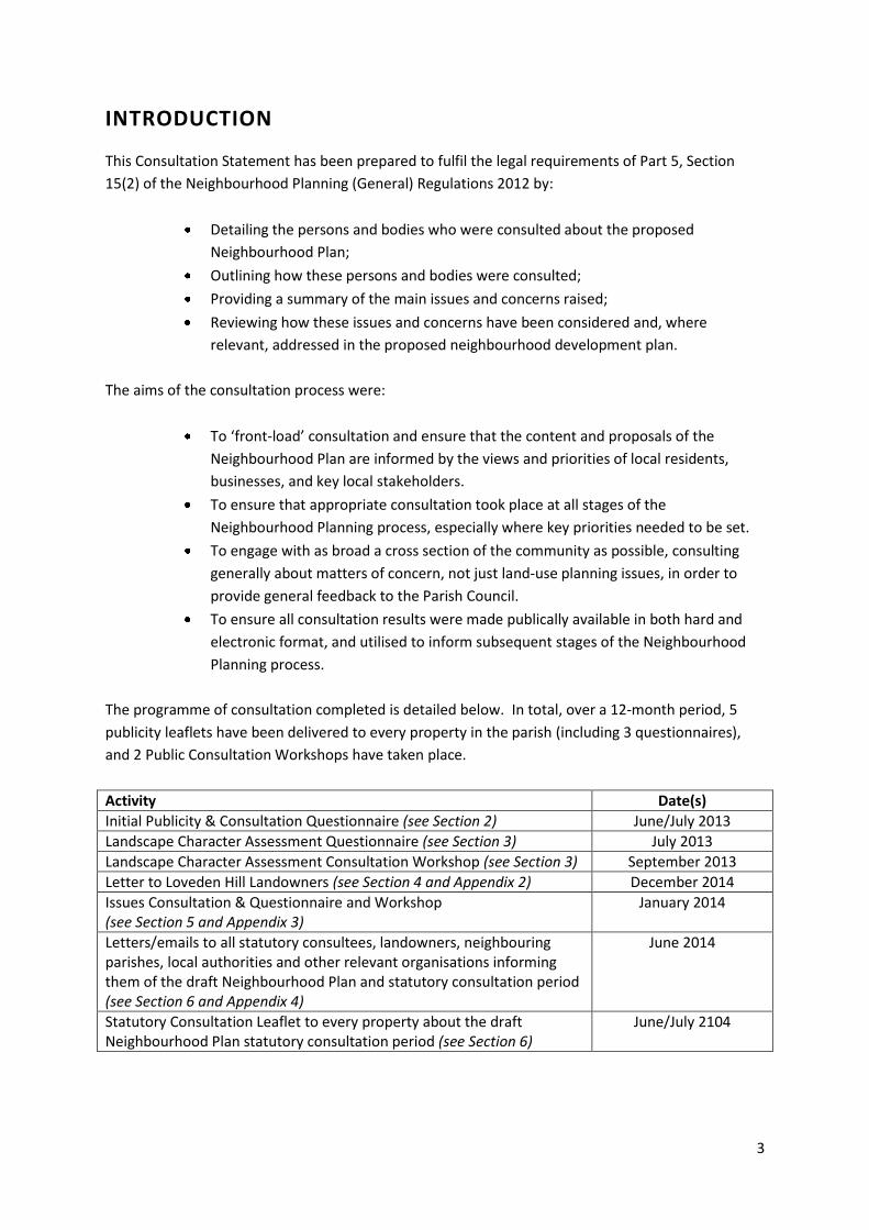
INTRODUCTION
This Consultation Statement has been prepared to fulfil the legal requirements of Part 5, Section
15(2) of the Neighbourhood Planning (General) Regulations 2012 by:
Detailing the persons and bodies who were consulted about the proposed
Neighbourhood Plan;
Outlining how these persons and bodies were consulted;
Providing a summary of the main issues and concerns raised;
Reviewing how these issues and concerns have been considered and, where
relevant, addressed in the proposed neighbourhood development plan.
The aims of the consultation process were:
To ‘front-load’ consultation and ensure that the content and proposals of the
Neighbourhood Plan are informed by the views and priorities of local residents,
businesses, and key local stakeholders.
To ensure that appropriate consultation took place at all stages of the
Neighbourhood Planning process, especially where key priorities needed to be set.
To engage with as broad a cross section of the community as possible, consulting
generally about matters of concern, not just land-use planning issues, in order to
provide general feedback to the Parish Council.
To ensure all consultation results were made publically available in both hard and
electronic format, and utilised to inform subsequent stages of the Neighbourhood
Planning process.
The programme of consultation completed is detailed below. In total, over a 12-month period, 5
publicity leaflets have been delivered to every property in the parish (including 3 questionnaires),
and 2 Public Consultation Workshops have taken place.
Activity Date(s)
Initial Publicity & Consultation Questionnaire (see Section 2) June/July 2013
Landscape Character Assessment Questionnaire (see Section 3) July 2013
Landscape Character Assessment Consultation Workshop (see Section 3) September 2013
Letter to Loveden Hill Landowners (see Section 4 and Appendix 2) December 2014
Issues Consultation & Questionnaire and Workshop (see Section 5 and Appendix 3)
January 2014
Letters/emails to all statutory consultees, landowners, neighbouring parishes, local authorities and other relevant organisations informing them of the draft Neighbourhood Plan and statutory consultation period (see Section 6 and Appendix 4)
June 2014
Statutory Consultation Leaflet to every property about the draft Neighbourhood Plan statutory consultation period (see Section 6)
June/July 2104
4
1. Designation of the Neighbourhood Plan Area
The Parish Council first considered applying for designation of the Parish as a neighbourhood
planning area during 2012, and made a formal decision to apply to South Kesteven District Council at
their meeting on 27th September 2012. The primary interest in preparing a Neighbourhood Plan for
the Parish was to invigorate local consultation and the involvement of residents in determining
which matters of concern the Parish Council should be addressing. As a large part of their activities
involved responding to planning applications, it was felt that a Neighbourhood Plan, prepared with
extensive local consultation, would provide a more definitive guide as to what was needed and
wanted.
South Kesteven District Council accepted the application and, following a 6 week period of
advertisement during which no representations were received, the Council formally designated
Hough on the Hill Parish as a Neighbourhood Planning Area on 26th February 2013.
Initially the Parish Council were unsure how best to proceed, but enquiries were made amongst
residents for those interested, or with any knowledge of community planning, to come forward. On
the advice of a resident, the Parish Council agreed at its meeting on 23rd May 2013 to set up a small
Project Team to begin to take forward the work and plan the initial consultation process. It was also
agreed to seek government funding through Locality.
2. Neighbourhood Planning Project Team
The Neighbourhood Planning Project Team (NPPT) comprised 2 Parish Councillors and up to 6 local
residents. Membership has changed during preparation of the Plan, but has included:
Roger Kingscott (Parish Councillor, Chair throughout)
Marilyn Taylor (Resident member, Secretary throughout)
Louise Barrett (Resident member, throughout)
Penny Milnes (Resident member from October 2013, and then as a Parish Councillor from July 2014)
Jane Orchiston (initially as a Parish Councillor and then as a Resident member from January 2014)
John Halton (Resident member throughout)
Sue Morgan (Parish Councillor, April to July 2014 only)
Roger Twelvetrees (Resident member from October 2013)
The full NPPT Terms of Reference are attached at Appendix 1. The main responsibilities are:
fundraising and funding applications to support neighbourhood plan activity
recommendations for commissioning of specific areas of evidence and analysis as required
management of consultants appointed by the Parish Council
management of expenditure within budget allocations approved by the Parish Council
preparation and distribution of publicity
community consultation and engagement activities
consultation and liaison with all relevant local stakeholders and with neighbouring Parishes
liaison with South Kesteven District Council to support the Plan’s development
scoping of the Plan’s objectives
drafting of relevant content and policies for approval by the Parish Council
5
In total the NPPT has held 12 meetings, all of which have been publicised on the three village
noticeboards as open to the public to attend (South Kesteven District Council has also been invited
to attend all meetings). A Public Forum session is held at the commencement of each meeting for
residents to raise any matters of concern, and comments are also invited on each agenda item
discussion. Minutes are made available on the Neighbourhood Plan website.
An email mailing list has also been gradually compiled from returned questionnaires and people
attending consultation workshops throughout the Neighbourhood Plan preparation period. The list
has grown to over 80 persons, and is used to provide regular updates and information, and to give
notice of meetings and other relevant activities.
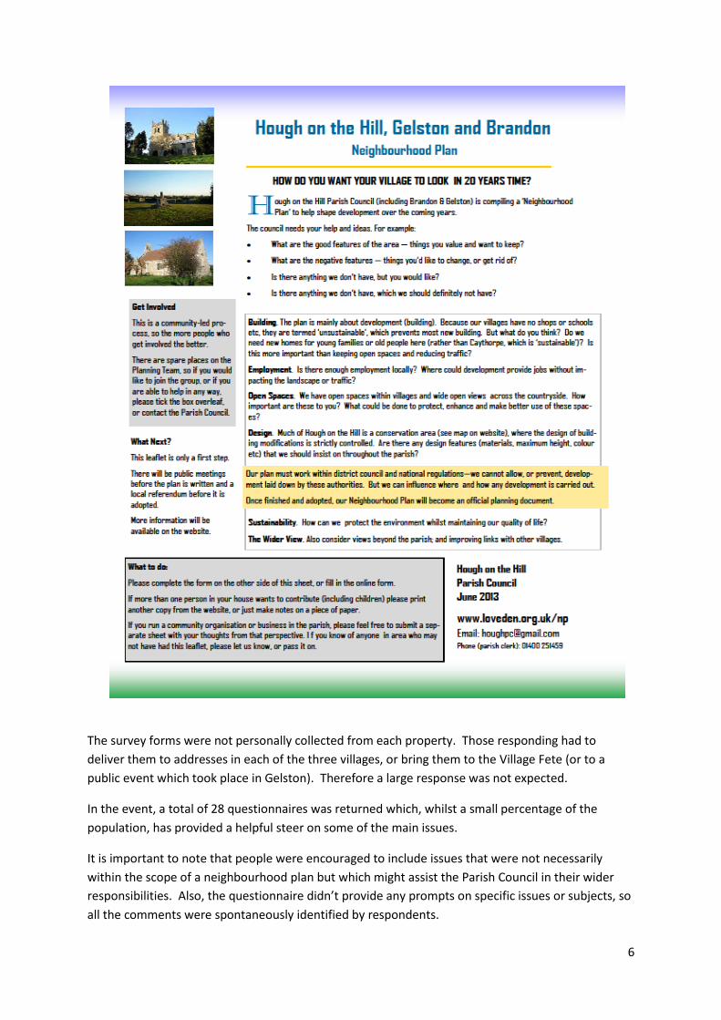
3. Initial Consultation (June 2013)
It was agreed that residents should be involved from the very start of the process of compiling a
Neighbourhood Plan so the first activity organised by the NPPT was the Initial Consultation exercise
in June 2013 designed to scope the issues that people would like to see addressed, either in a
Neighbourhood Plan (if it was an issue relating to the use or development of land), or by the Parish
Council as part of their other responsibilities and activities. This involved:
distributing a leaflet and short survey form to every property in the Parish asking for initial
views, especially about particularly good or negative features; (see below)
setting up a website (www.loveden.org.uk/np) for people to find out more about what a
Neighbourhood Plan was, and what was involved in preparing one; the leaflet and
questionnaire were also available on the website;
running a publicity stall at the Hough on the Hill Village Fete in July 2013
writing to utility providers to alert them that a neighbourhood plan was being prepared and
requesting their input on any relevant information that would affect the Plan
establishing regular contact and liaison with South Kesteven District Council
6
The survey forms were not personally collected from each property. Those responding had to
deliver them to addresses in each of the three villages, or bring them to the Village Fete (or to a
public event which took place in Gelston). Therefore a large response was not expected.
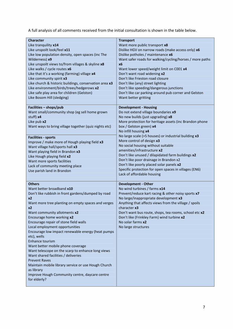
In the event, a total of 28 questionnaires was returned which, whilst a small percentage of the
population, has provided a helpful steer on some of the main issues.
It is important to note that people were encouraged to include issues that were not necessarily
within the scope of a neighbourhood plan but which might assist the Parish Council in their wider
responsibilities. Also, the questionnaire didn’t provide any prompts on specific issues or subjects, so
all the comments were spontaneously identified by respondents.
7
A full analysis of all comments received from the initial consultation is shown in the table below.
Character Like tranquility x14 Like unspoilt look/feel x11 Like low population density, open spaces (inc The Wilderness) x9 Like unspoilt views to/from villages & skyline x8 Like walks / cycle routes x6 Like that it’s a working (farming) village x4 Like community spirit x3 Like church & historic buildings, conservation area x3 Like environment/birds/trees/hedgerows x2 Like safe play area for children (Gelston) Like Bosom Hill (sledging)
Transport Want more public transport x8 Dislike HGV on narrow roads (make access only) x6 Dislike potholes / maintenance x6 Want safer roads for walking/cycling/horses / more paths x6 Want lower speed/weight limit on C001 x4 Don’t want road widening x2 Don’t like Frieston road closure Don’t like (any) street lighting Don’t like speeding/dangerous junctions Don’t like car parking around pub corner and Gelston Want better gritting
Facilities – shops/pub Want small/community shop (eg sell home grown stuff) x4 Like pub x2 Want ways to bring village together (quiz nights etc)
Development - Housing Do not extend village boundaries x9 No new builds (just upgrading) x8 More protection for heritage assets (inc Brandon phone box / Gelston green) x4 No infill housing x4 No large scale (>5 houses) or industrial building x3 More control of design x3 No social housing without suitable amenities/infrastructure x2 Don’t like unused / dilapidated farm buildings x2 Don’t like poor drainage in Brandon x2 Don’t like poorly placed solar panels x2 Specific protection for open spaces in villages (EN6) Lack of affordable housing
Facilities - sports Improve / make more of Hough playing field x3 Want village hall/sports hall x3 Want playing field in Brandon x3 Like Hough playing field x2 Want more sports facilities Lack of community meeting place Use parish land in Brandon
Others Want better broadband x10 Don’t like rubbish in front gardens/dumped by road x2 Want more tree planting on empty spaces and verges x2 Want community allotments x2 Encourage home working x2 Encourage repair of stone field walls Local employment opportunities Encourage low impact renewable energy (heat pumps etc), wells Enhance tourism Want better mobile phone coverage Want telescope on the scarp to enhance long views Want shared facilities / deliveries Prevent Raves Maintain mobile library service or use Hough Church as library Improve Hough Community centre, daycare centre for elderly?
Development - Other No wind turbines / farms x14 Prevent/reduce kart racing & other noisy sports x7 No large/inappropriate development x3 Anything that affects views from the village / spoils character x3 Don’t want bus route, shops, tea rooms, school etc x2 Don’t like (Frinkley Farm) wind turbine x2 No solar farms x2 No large structures
8
This exercise gave indications of residents’ views on the following issues:
Landscape Character
It was immediately clear that people’s main focus was on the importance of the landscape,
its tranquillity and unspoilt character, and on the history and heritage evident in all three of
the villages.
Housing and New Development
It was clear that those who responded did not want any change to the size of the villages, or
to their look or feel. There was support for heritage and conservation measures, and for
tighter controls of new build and conversion designs. Concern about wind farm development
featured highly, and also dislike of motorsport noise, and generally people indicated that
they did not want any large, industrial or noisy developments.
Road Safety
There were quite a few comments relating to roads and transport. The physical condition of
the roads and road safety issues in particular figure quite highly, along with concerns about
through traffic and speeds.
Facilities
There were several responses relating to community facilities, especially sports provision.
Other Issues
The most consistently raised issue was the need for improved Broadband provision.
The findings from this initial survey were written up as a Summary Report and discussed by the NPPT
at their meeting in July 2013 (and were also reported to the Parish Council). The NPPT used this
information to guide the identification of the ‘evidence’ to be analysed and used in compiling the
wider content of the Neighbourhood Plan, and particularly the key characteristics of the Parish, its
people and its economic activity.
4. Landscape Character Assessment
It was agreed that a Landscape Character Assessment, to be undertaken with professional
consultancy support, would be the best approach for identifying the distinctive landscape features
within the Parish more clearly, and considering how these might be addressed within a
Neighbourhood Plan.
With the financial aid of a Government grant (through Locality), the Parish Council agreed to the
appointment of Allen Pyke Associates to carry out a landscape character assessment. This work was
commissioned jointly with an adjoining Parish who were also preparing a Neighbourhood Plan in
order to reduce costs for both Parishes, although each Parish was provided with a separate
assessment.
9
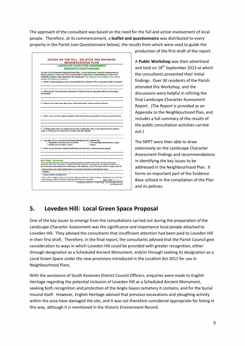
The approach of the consultant was based on the need for the full and active involvement of local
people. Therefore, at its commencement, a leaflet and questionnaire was distributed to every
property in the Parish (see Questionnaire below), the results from which were used to guide the
production of the first draft of the report.
A Public Workshop was then advertised
and held on 18th September 2013 at which
the consultants presented their initial
findings. Over 30 residents of the Parish
attended this Workshop, and the
discussions were helpful in refining the
final Landscape Character Assessment
Report. (The Report is provided as an
Appendix to the Neighbourhood Plan, and
includes a full summary of the results of
the public consultation activities carried
out.)
The NPPT were then able to draw
extensively on the Landscape Character
Assessment findings and recommendations
in identifying the key issues to be
addressed in the Neighbourhood Plan. It
forms an important part of the Evidence
Base utilised in the compilation of the Plan
and its policies.
5. Loveden Hill: Local Green Space Proposal
One of the key issues to emerge from the consultations carried out during the preparation of the
Landscape Character Assessment was the significance and importance local people attached to
Loveden Hill. They advised the consultants that insufficient attention had been paid to Loveden Hill
in their first draft. Therefore, in the final report, the consultants advised that the Parish Council give
consideration to ways in which Loveden Hill could be provided with greater recognition, either
through designation as a Scheduled Ancient Monument, and/or through seeking its designation as a
Local Green Space under the new provisions introduced in the Localism Act 2011 for use in
Neighbourhood Plans.
With the assistance of South Kesteven District Council Officers, enquiries were made to English
Heritage regarding the potential inclusion of Loveden Hill as a Scheduled Ancient Monument,
seeking both recognition and protection of the Anglo-Saxon cemetery it contains, and for the burial
mound itself. However, English Heritage advised that previous excavations and ploughing activity
within the area have damaged the site, and it was not therefore considered appropriate for listing in
this way, although it is mentioned in the Historic Environment Record.
10
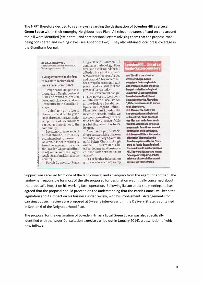
The NPPT therefore decided to seek views regarding the designation of Loveden Hill as a Local
Green Space within their emerging Neighbourhood Plan. All relevant owners of land on and around
the hill were identified (six in total) and sent personal letters advising them that the proposal was
being considered and inviting views (see Appendix Two). They also obtained local press coverage in
the Grantham Journal:
Support was received from one of the landlowners, and an enquiry from the agent for another. The
landowner responsible for most of the site proposed for designation was initially concerned about
the proposal’s impact on his working farm operation. Following liaison and a site meeting, he has
agreed that the proposal should proceed on the understanding that the Parish Council will keep the
legislation and its impact on his business under review, with his involvement. Arrangements for
carrying out such reviews are proposed at 5-yearly intervals within the Delivery Strategy contained
in Section 6 of the Neighbourhood Plan.
The proposal for the designation of Loveden Hill as a Local Green Space was also specifically
identified with the Issues Consultation exercise carried out in January 2014), a description of which
now follows.
11
6. Issues Consultation (January 2014)
Attention now reverted to the Neighbourhood Plan in its entirety. With the key descriptive parts of
the Plan drafted, the NPPT needed to undertake a more focused and detailed consultation exercise
locally to make sure that the key emerging issues were the right ones, that emerging proposals were
on the right track, and to check for any other issues that should be raised and considered in the
writing of the Plan.
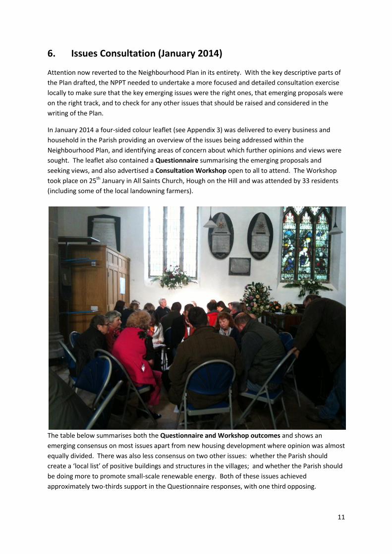
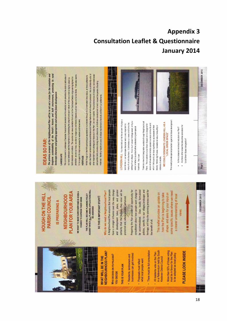
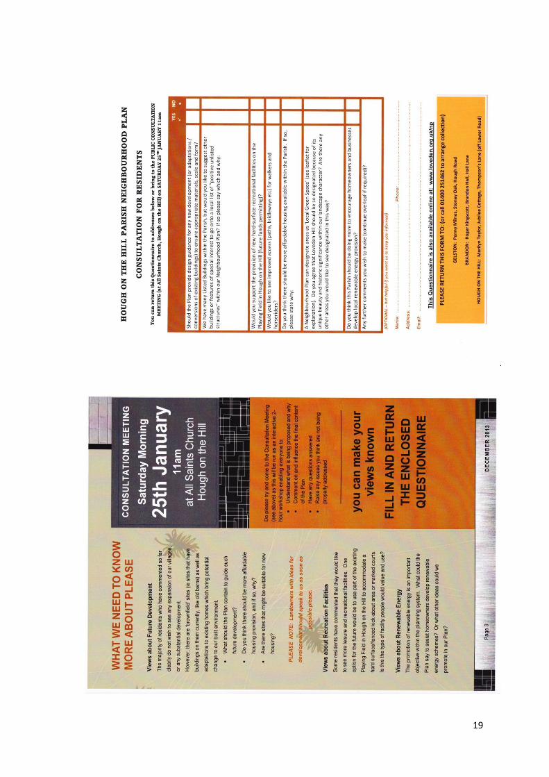
In January 2014 a four-sided colour leaflet (see Appendix 3) was delivered to every business and
household in the Parish providing an overview of the issues being addressed within the
Neighbourhood Plan, and identifying areas of concern about which further opinions and views were
sought. The leaflet also contained a Questionnaire summarising the emerging proposals and
seeking views, and also advertised a Consultation Workshop open to all to attend. The Workshop
took place on 25th January in All Saints Church, Hough on the Hill and was attended by 33 residents
(including some of the local landowning farmers).
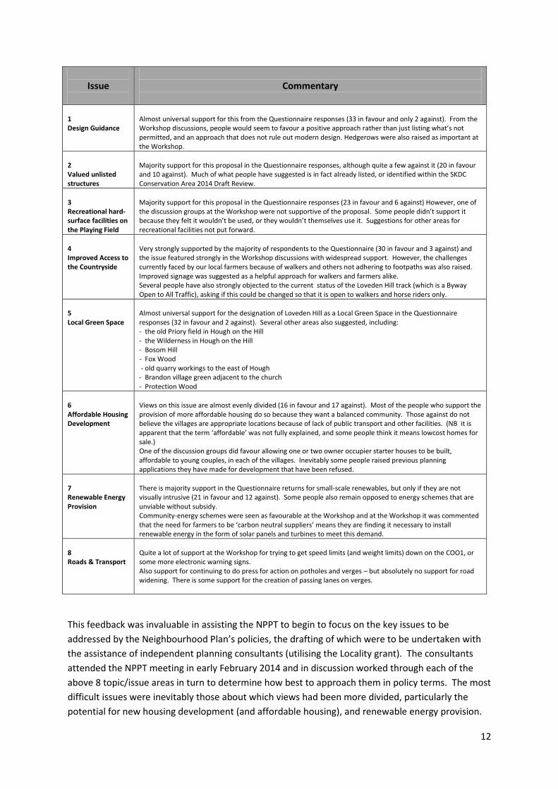
The table below summarises both the Questionnaire and Workshop outcomes and shows an
emerging consensus on most issues apart from new housing development where opinion was almost
equally divided. There was also less consensus on two other issues: whether the Parish should
create a ‘local list’ of positive buildings and structures in the villages; and whether the Parish should
be doing more to promote small-scale renewable energy. Both of these issues achieved
approximately two-thirds support in the Questionnaire responses, with one third opposing.
12
This feedback was invaluable in assisting the NPPT to begin to focus on the key issues to be
addressed by the Neighbourhood Plan’s policies, the drafting of which were to be undertaken with
the assistance of independent planning consultants (utilising the Locality grant). The consultants
attended the NPPT meeting in early February 2014 and in discussion worked through each of the
above 8 topic/issue areas in turn to determine how best to approach them in policy terms. The most
difficult issues were inevitably those about which views had been more divided, particularly the
potential for new housing development (and affordable housing), and renewable energy provision.
Issue
Commentary
1 Design Guidance
Almost universal support for this from the Questionnaire responses (33 in favour and only 2 against). From the Workshop discussions, people would seem to favour a positive approach rather than just listing what’s not permitted, and an approach that does not rule out modern design. Hedgerows were also raised as important at the Workshop.
2 Valued unlisted structures
Majority support for this proposal in the Questionnaire responses, although quite a few against it (20 in favour and 10 against). Much of what people have suggested is in fact already listed, or identified within the SKDC Conservation Area 2014 Draft Review.
3 Recreational hard-surface facilities on the Playing Field
Majority support for this proposal in the Questionnaire responses (23 in favour and 6 against) However, one of the discussion groups at the Workshop were not supportive of the proposal. Some people didn’t support it because they felt it wouldn’t be used, or they wouldn’t themselves use it. Suggestions for other areas for recreational facilities not put forward.
4 Improved Access to the Countryside
Very strongly supported by the majority of respondents to the Questionnaire (30 in favour and 3 against) and the issue featured strongly in the Workshop discussions with widespread support. However, the challenges currently faced by our local farmers because of walkers and others not adhering to footpaths was also raised. Improved signage was suggested as a helpful approach for walkers and farmers alike. Several people have also strongly objected to the current status of the Loveden Hill track (which is a Byway Open to All Traffic), asking if this could be changed so that it is open to walkers and horse riders only.
5 Local Green Space
Almost universal support for the designation of Loveden Hill as a Local Green Space in the Questionnaire responses (32 in favour and 2 against). Several other areas also suggested, including: - the old Priory field in Hough on the Hill - the Wilderness in Hough on the Hill - Bosom Hill - Fox Wood - old quarry workings to the east of Hough - Brandon village green adjacent to the church - Protection Wood
6 Affordable Housing Development
Views on this issue are almost evenly divided (16 in favour and 17 against). Most of the people who support the provision of more affordable housing do so because they want a balanced community. Those against do not believe the villages are appropriate locations because of lack of public transport and other facilities. (NB it is apparent that the term ‘affordable’ was not fully explained, and some people think it means lowcost homes for sale.) One of the discussion groups did favour allowing one or two owner occupier starter houses to be built, affordable to young couples, in each of the villages. Inevitably some people raised previous planning applications they have made for development that have been refused.
7 Renewable Energy Provision
There is majority support in the Questionnaire returns for small-scale renewables, but only if they are not visually intrusive (21 in favour and 12 against). Some people also remain opposed to energy schemes that are unviable without subsidy. Community-energy schemes were seen as favourable at the Workshop and at the Workshop it was commented that the need for farmers to be ‘carbon neutral suppliers’ means they are finding it necessary to install renewable energy in the form of solar panels and turbines to meet this demand.
8 Roads & Transport
Quite a lot of support at the Workshop for trying to get speed limits (and weight limits) down on the COO1, or some more electronic warning signs. Also support for continuing to do press for action on potholes and verges – but absolutely no support for road widening. There is some support for the creation of passing lanes on verges.
13
Given the need for compliance with SKDC policy, which does not view villages in our Parish as
‘sustainable locations’ for new development, it was decided that the Neighbourhood Plan should not
propose development or identify particular sites. The view was that with the inclusion of Design
Guidance, and the identification of unlisted, but distinctive features or buildings residents identified
as being of value, sufficient focus could be given to residents’ concerns about intrusive and
unattractive development in any proposals coming forward for planning permission. The NPPT’s
feelings were that change was a necessary part of Parish life, but that the Plan should provide a
stronger steer on the type of developments or conversions that could add value to heritage and
settings, and not detract from the value of the landscape. (NB It should be noted that at about this
time SKDC undertook a re-appraisal of the Hough on the Hill village Conservation Area which linked
very helpfully to these emerging ideas for the Neighbourhood Plan.)
After much debate, it was also agreed that the draft Neighbourhood Plan should as far as possible be
positive about the potential for small-scale renewable energy, or community energy schemes, whilst
not going against the community’s well-expressed views on large-scale windfarms.
7. Statutory Consultation on the Draft Neighbourhood Plan
The NPPT continued towards producing a finalised draft of the Neighbourhood Plan, drawing on .
professional assistance from independent planning consultants to help draft the proposed policies,
but with all other sections written by members of the NPPT. The Draft Neighbourhood Plan was
finally approved for public consultation by the Parish Council at its meeting on 15th May 2014.
The period of consultation ran from 1st June to 23rd July 2014 (thus meeting the minimum 6-week
statutory period). The draft Neighbourhood Plan was made available on the website
(www.loveden.org.uk/np), and hard copies were also available for viewing in each of the three
villages. Every property was leafleted to provide information about the consultation, where to view
the draft Plan, how to make comments, and the closing date for comments. The leaflet also
provided a brief summary of the main objectives of the Plan, and explained what would happen
after the consultation. The 80+ persons on the email list were also advised of the consultation
process and timescale.
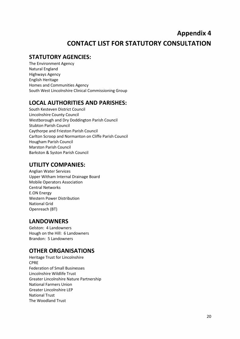
Letters, or emails, were sent to all relevant statutory consultees, landowners, neighbouring parishes
and other relevant organisations (see Appendix 4 for the list of those contacted). The letter advised
that the draft Neighbourhood Plan was out for consultation, where to view the Plan, and the closing
date for any comments and observations.
Members of the NPPT also attended the Hough on the Hill Village Fete on 5th July, running a publicity
stall about the draft Neighbourhood Plan consultation, and reminding people of the closing date for
comments.
All comments received by the closing date (23rd July 2014) were each considered individually at the
NPPT meeting held on 30th July 2014, with the majority received from SKDC and other statutory or
stakeholder bodies (apart from a very helpful submission from the largest farm in the Parish). It was
agreed that many of the comments made could and should be addressed by amendments to the
14
draft Plan. However, there were a few comments, including some made by SKDC, which were more
difficult to interpret and it was agreed further guidance from SKDC should be sought. Following this
action, final amendments were made to the Plan. Appendix 5 provides a summary of all the
comments received, and the action taken.
Work was also completed on the Basic Conditions Statement, this Statement of Consultation and the
presentation of the Evidence Base – all of which would need to be approved by the Parish Council
and submitted to SKDC alongside the finally agreed Neighbourhood Plan. The NPPT are indebted to
the advice and assistance received from the Planning Aid Consultant provided by Locality with this
stage of their work.
8. Conclusion
The publicity, engagement and consultation completed throughout the production of the Hough on
the Hill Parish Neighbourhood Plan has been open and transparent, with many opportunities
provided for those that live, work, and do business within the Neighbourhood Area to feed into the
process, make comment, and to raise issues, priorities and concerns.
The Parish Council considered and accepted this Statement of Consultation at its meeting held on
25th September 2014 as a true record of all the consultation activities that have taken place. It is the
Parish Council’s opinion that all statutory requirements have been met and that this Statement
complies with Part 5, Section 15 of the Neighbourhood Planning (General) Regulations 2012.
15
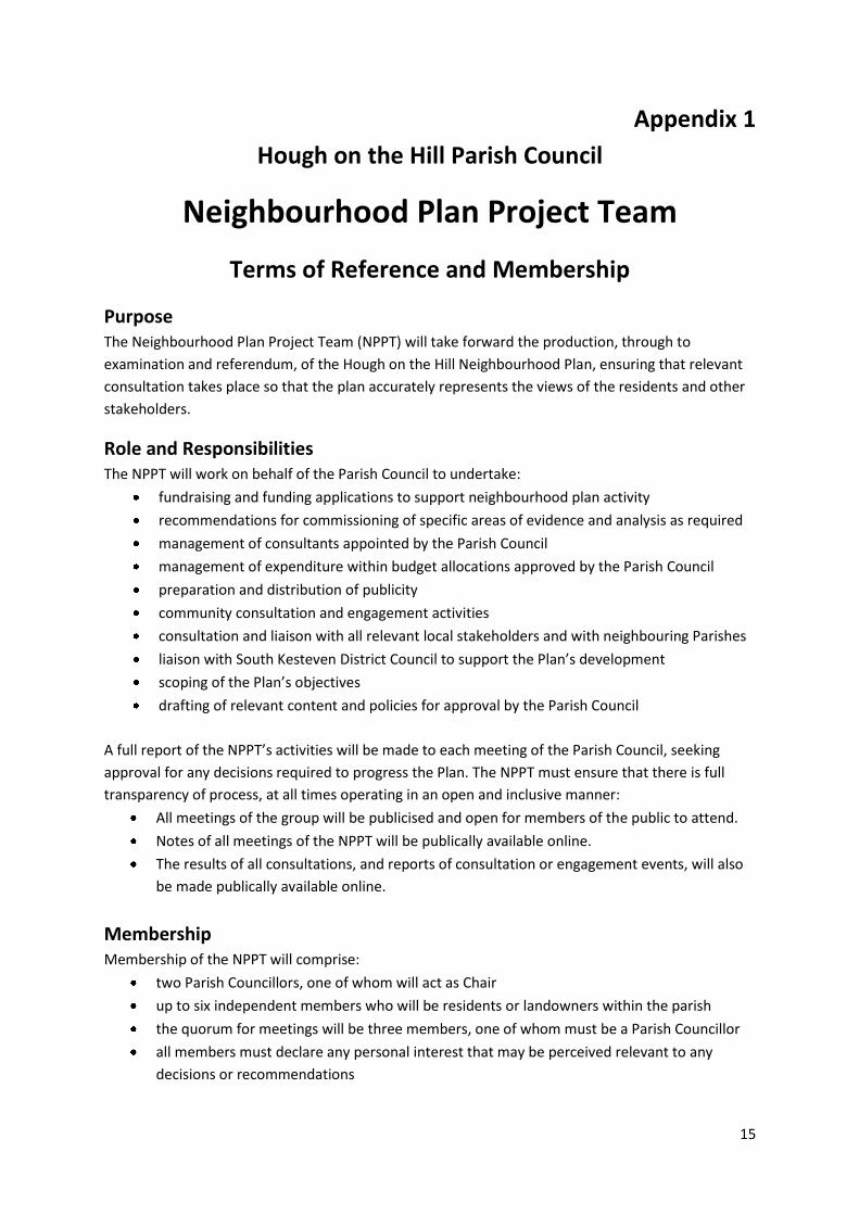
Appendix 1
Hough on the Hill Parish Council
Neighbourhood Plan Project Team
Terms of Reference and Membership
Purpose The Neighbourhood Plan Project Team (NPPT) will take forward the production, through to
examination and referendum, of the Hough on the Hill Neighbourhood Plan, ensuring that relevant
consultation takes place so that the plan accurately represents the views of the residents and other
stakeholders.
Role and Responsibilities The NPPT will work on behalf of the Parish Council to undertake:
fundraising and funding applications to support neighbourhood plan activity
recommendations for commissioning of specific areas of evidence and analysis as required
management of consultants appointed by the Parish Council
management of expenditure within budget allocations approved by the Parish Council
preparation and distribution of publicity
community consultation and engagement activities
consultation and liaison with all relevant local stakeholders and with neighbouring Parishes
liaison with South Kesteven District Council to support the Plan’s development
scoping of the Plan’s objectives
drafting of relevant content and policies for approval by the Parish Council
A full report of the NPPT’s activities will be made to each meeting of the Parish Council, seeking
approval for any decisions required to progress the Plan. The NPPT must ensure that there is full
transparency of process, at all times operating in an open and inclusive manner:
All meetings of the group will be publicised and open for members of the public to attend.
Notes of all meetings of the NPPT will be publically available online.
The results of all consultations, and reports of consultation or engagement events, will also
be made publically available online.
Membership Membership of the NPPT will comprise:
two Parish Councillors, one of whom will act as Chair
up to six independent members who will be residents or landowners within the parish
the quorum for meetings will be three members, one of whom must be a Parish Councillor
all members must declare any personal interest that may be perceived relevant to any
decisions or recommendations
16
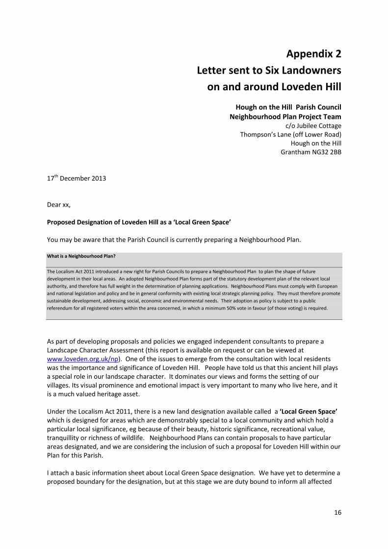
Appendix 2
Letter sent to Six Landowners
on and around Loveden Hill
Hough on the Hill Parish Council Neighbourhood Plan Project Team
c/o Jubilee Cottage Thompson’s Lane (off Lower Road)
Hough on the Hill Grantham NG32 2BB
17th December 2013 Dear xx, Proposed Designation of Loveden Hill as a ‘Local Green Space’ You may be aware that the Parish Council is currently preparing a Neighbourhood Plan. What is a Neighbourhood Plan?
The Localism Act 2011 introduced a new right for Parish Councils to prepare a Neighbourhood Plan to plan the shape of future
development in their local areas. An adopted Neighbourhood Plan forms part of the statutory development plan of the relevant local
authority, and therefore has full weight in the determination of planning applications. Neighbourhood Plans must comply with European
and national legislation and policy and be in general conformity with existing local strategic planning policy. They must therefore promote
sustainable development, addressing social, economic and environmental needs. Their adoption as policy is subject to a public
referendum for all registered voters within the area concerned, in which a minimum 50% vote in favour (of those voting) is required.
As part of developing proposals and policies we engaged independent consultants to prepare a Landscape Character Assessment (this report is available on request or can be viewed at www.loveden.org.uk/np). One of the issues to emerge from the consultation with local residents was the importance and significance of Loveden Hill. People have told us that this ancient hill plays a special role in our landscape character. It dominates our views and forms the setting of our villages. Its visual prominence and emotional impact is very important to many who live here, and it is a much valued heritage asset. Under the Localism Act 2011, there is a new land designation available called a ‘Local Green Space’ which is designed for areas which are demonstrably special to a local community and which hold a particular local significance, eg because of their beauty, historic significance, recreational value, tranquillity or richness of wildlife. Neighbourhood Plans can contain proposals to have particular areas designated, and we are considering the inclusion of such a proposal for Loveden Hill within our Plan for this Parish. I attach a basic information sheet about Local Green Space designation. We have yet to determine a proposed boundary for the designation, but at this stage we are duty bound to inform all affected
17
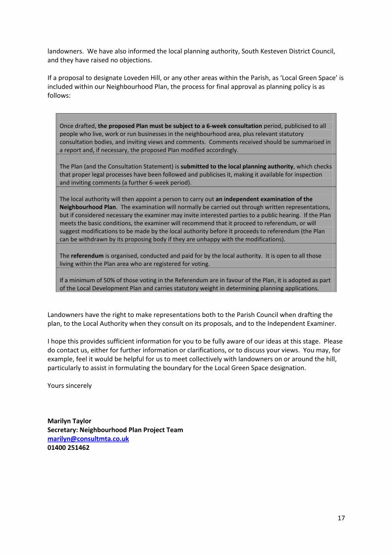
landowners. We have also informed the local planning authority, South Kesteven District Council, and they have raised no objections. If a proposal to designate Loveden Hill, or any other areas within the Parish, as ‘Local Green Space’ is included within our Neighbourhood Plan, the process for final approval as planning policy is as follows:
Landowners have the right to make representations both to the Parish Council when drafting the plan, to the Local Authority when they consult on its proposals, and to the Independent Examiner. I hope this provides sufficient information for you to be fully aware of our ideas at this stage. Please do contact us, either for further information or clarifications, or to discuss your views. You may, for example, feel it would be helpful for us to meet collectively with landowners on or around the hill, particularly to assist in formulating the boundary for the Local Green Space designation. Yours sincerely Marilyn Taylor Secretary: Neighbourhood Plan Project Team [email protected] 01400 251462
Once drafted, the proposed Plan must be subject to a 6-week consultation period, publicised to all people who live, work or run businesses in the neighbourhood area, plus relevant statutory consultation bodies, and inviting views and comments. Comments received should be summarised in a report and, if necessary, the proposed Plan modified accordingly.
The Plan (and the Consultation Statement) is submitted to the local planning authority, which checks that proper legal processes have been followed and publicises it, making it available for inspection and inviting comments (a further 6-week period).
The local authority will then appoint a person to carry out an independent examination of the Neighbourhood Plan. The examination will normally be carried out through written representations, but if considered necessary the examiner may invite interested parties to a public hearing. If the Plan meets the basic conditions, the examiner will recommend that it proceed to referendum, or will suggest modifications to be made by the local authority before it proceeds to referendum (the Plan can be withdrawn by its proposing body if they are unhappy with the modifications).
The referendum is organised, conducted and paid for by the local authority. It is open to all those living within the Plan area who are registered for voting.
If a minimum of 50% of those voting in the Referendum are in favour of the Plan, it is adopted as part of the Local Development Plan and carries statutory weight in determining planning applications.
18
Appendix 3
Consultation Leaflet & Questionnaire
January 2014
19
20
Appendix 4
CONTACT LIST FOR STATUTORY CONSULTATION
STATUTORY AGENCIES: The Environment Agency Natural England Highways Agency English Heritage Homes and Communities Agency South West Lincolnshire Clinical Commissioning Group
LOCAL AUTHORITIES AND PARISHES: South Kesteven District Council Lincolnshire County Council Westborough and Dry Doddington Parish Council Stubton Parish Council Caythorpe and Frieston Parish Council Carlton Scroop and Normanton on Cliffe Parish Council Hougham Parish Council Marston Parish Council Barkston & Syston Parish Council
UTILITY COMPANIES: Anglian Water Services Upper Witham Internal Drainage Board Mobile Operators Association Central Networks E.ON Energy Western Power Distribution National Grid Openreach (BT)
LANDOWNERS Gelston: 4 Landowners Hough on the Hill: 6 Landowners Brandon: 5 Landowners
OTHER ORGANISATIONS Heritage Trust for Lincolnshire CPRE Federation of Small Businesses Lincolnshire Wildlife Trust Greater Lincolnshire Nature Partnership National Farmers Union Greater Lincolnshire LEP National Trust The Woodland Trust
Appendix 5
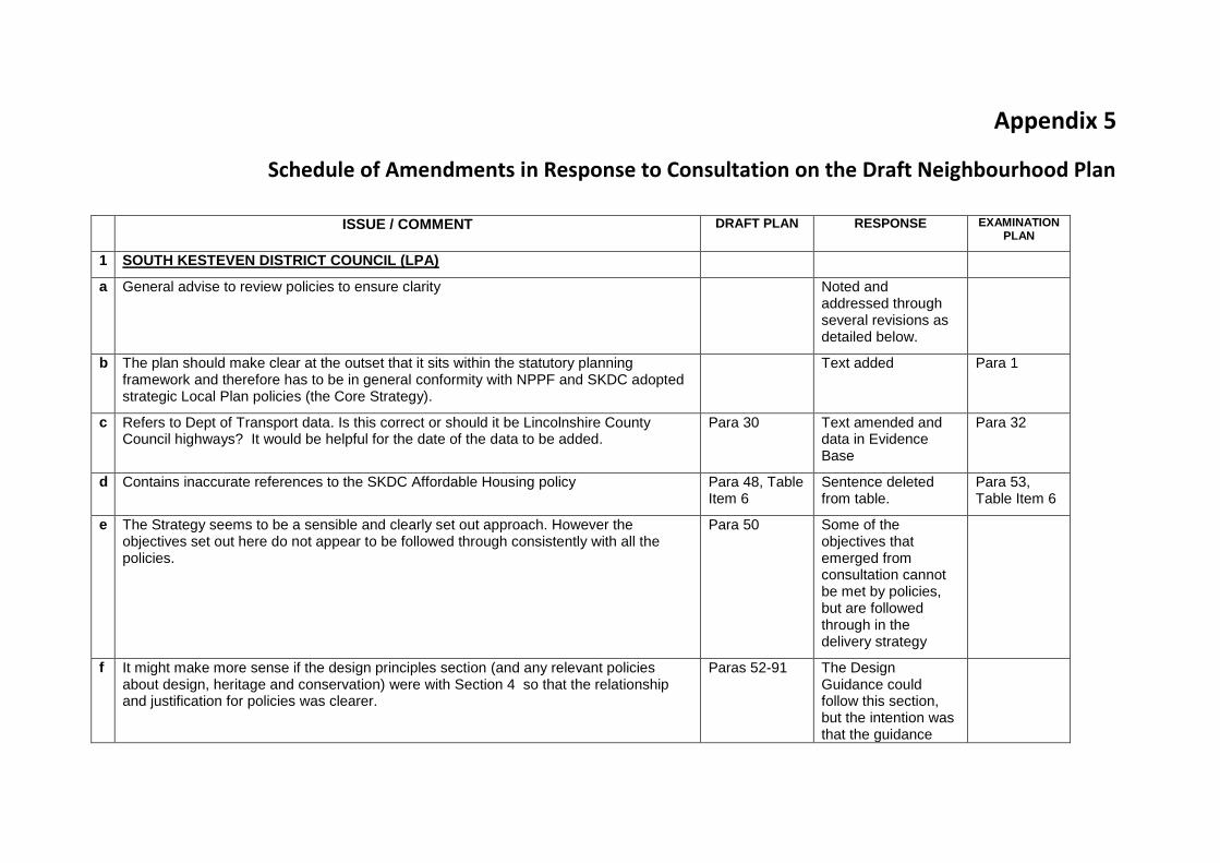
Schedule of Amendments in Response to Consultation on the Draft Neighbourhood Plan
ISSUE / COMMENT DRAFT PLAN RESPONSE EXAMINATION
PLAN
1 SOUTH KESTEVEN DISTRICT COUNCIL (LPA)
a General advise to review policies to ensure clarity Noted and addressed through several revisions as detailed below.
b The plan should make clear at the outset that it sits within the statutory planning framework and therefore has to be in general conformity with NPPF and SKDC adopted strategic Local Plan policies (the Core Strategy).
Text added Para 1
c Refers to Dept of Transport data. Is this correct or should it be Lincolnshire County Council highways? It would be helpful for the date of the data to be added.
Para 30 Text amended and data in Evidence Base
Para 32
d Contains inaccurate references to the SKDC Affordable Housing policy Para 48, Table Item 6
Sentence deleted from table.
Para 53, Table Item 6
e The Strategy seems to be a sensible and clearly set out approach. However the objectives set out here do not appear to be followed through consistently with all the policies.
Para 50 Some of the objectives that emerged from consultation cannot be met by policies, but are followed through in the delivery strategy
f It might make more sense if the design principles section (and any relevant policies about design, heritage and conservation) were with Section 4 so that the relationship and justification for policies was clearer.
Paras 52-91 The Design Guidance could follow this section, but the intention was that the guidance
22
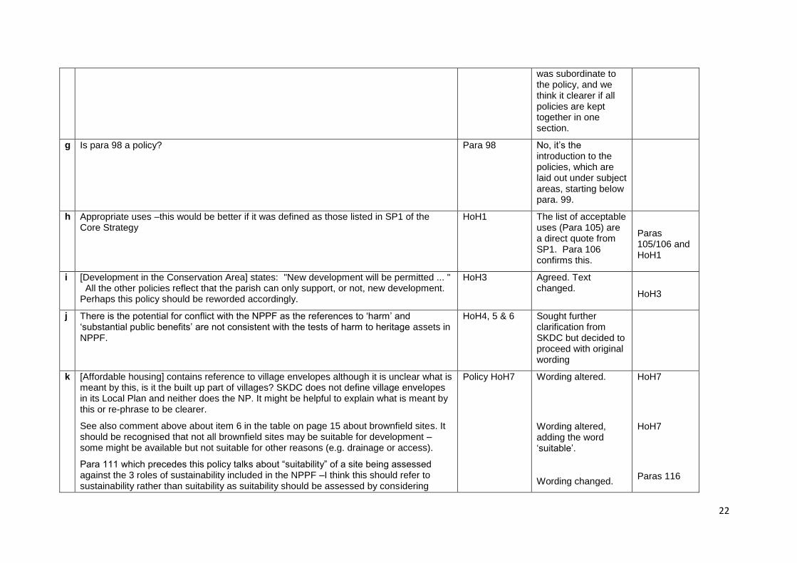
was subordinate to the policy, and we think it clearer if all policies are kept together in one section.
g Is para 98 a policy? Para 98 No, it‟s the introduction to the policies, which are laid out under subject areas, starting below para. 99.
h Appropriate uses –this would be better if it was defined as those listed in SP1 of the Core Strategy
HoH1 The list of acceptable uses (Para 105) are a direct quote from SP1. Para 106 confirms this.
Paras 105/106 and HoH1
i [Development in the Conservation Area] states: "New development will be permitted ... " All the other policies reflect that the parish can only support, or not, new development. Perhaps this policy should be reworded accordingly.
HoH3 Agreed. Text changed.
HoH3
j There is the potential for conflict with the NPPF as the references to „harm‟ and „substantial public benefits‟ are not consistent with the tests of harm to heritage assets in NPPF.
HoH4, 5 & 6 Sought further clarification from SKDC but decided to proceed with original wording
k [Affordable housing] contains reference to village envelopes although it is unclear what is meant by this, is it the built up part of villages? SKDC does not define village envelopes in its Local Plan and neither does the NP. It might be helpful to explain what is meant by this or re-phrase to be clearer.
See also comment above about item 6 in the table on page 15 about brownfield sites. It should be recognised that not all brownfield sites may be suitable for development – some might be available but not suitable for other reasons (e.g. drainage or access).
Para 111 which precedes this policy talks about “suitability” of a site being assessed against the 3 roles of sustainability included in the NPPF –I think this should refer to sustainability rather than suitability as suitability should be assessed by considering
Policy HoH7 Wording altered.
Wording altered, adding the word „suitable‟.
Wording changed.
HoH7
HoH7
Paras 116
23
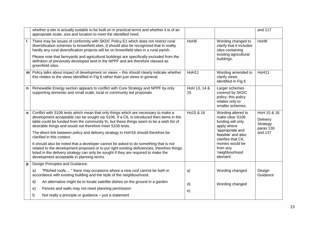
whether a site is actually suitable to be built on in practical terms and whether it is of an appropriate scale, size and location to meet the identified need.
and 117
l There may be issues of conformity with SKDC Policy E1 which does not restrict rural diversification schemes to brownfield sites. It should also be recognized that in reality hardly any rural diversification projects will be on brownfield sites in a rural parish.
Please note that farmyards and agricultural buildings are specifically excluded from the definition of previously developed land in the NPPF and are therefore classed as greenfield sites.
HoH8 Wording changed to clarify that it includes sites containing existing agricultural buildings.
HoH8
m Policy talks about impact of development on views – this should clearly indicate whether this relates to the views identified in Fig 6 rather than just views in general.
HoH11 Wording amended to clarify views identified in Fig 6
HoH11
n Renewable Energy section appears to conflict with Core Strategy and NPPF by only supporting domestic and small scale, local or community led proposals
HoH 13, 14 & 15
Larger schemes covered by SKDC policy; this policy relates only to smaller schemes.
o Conflict with S106 tests which mean that only things which are necessary to make a development acceptable can be sought via S106. If a CIL is introduced then items in the table could be funded from the community %, but these things seem to be a wish list of desirable things and would not therefore meet S106 tests.
The direct link between policy and delivery strategy in HoH16 should therefore be clarified in this context.
It should also be noted that a developer cannot be asked to do something that is not related to the development proposed or to put right existing deficiencies, therefore things listed in the delivery strategy can only be sought if they are required to make the development acceptable in planning terms.
Ho15 & 16 Wording altered to make clear S106 funding will only apply where ‟appropriate and feasible‟ and also clarifies that CIL monies would be from any „neighbourhood element‟.
HoH 15 & 16
Delivery Strategy paras 136 and 137
p Design Principles and Guidance:
a) “Pitched roofs.... “ there may occasions where a new roof cannot be both in accordance with existing building and the style of the neighbourhood.
d) An alternative might be to locate satellite dishes on the ground in a garden
e) Fences and walls may not need planning permission
f) Not really a principle or guidance – just a statement
a)
d)
e)
Wording changed.
Wording changed
Design Guidance
24
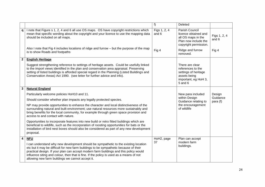
f) Deleted
q I note that Figure s 1, 2, 4 and 6 all use OS maps. OS have copyright restrictions which mean that specific wording about the copyright and your licence to use the mapping data should be included on all maps.
Also I note that Fig 4 includes locations of ridge and furrow – but the purpose of the map is to show Roads and footpaths
Figs 1, 2, 4 and 6
Fig 4
Parish Council licence obtained and all OS maps in the Plan now include the copyright permission.
Ridge and furrow removed.
Figs 1, 2, 4 and 6
Fig 4
2 English Heritage
Suggest strengthening reference to settings of heritage assets. Could be usefully linked to the import views identified in the plan and conservation area appraisal. Preserving setting of listed buildings is afforded special regard in the Planning (Listed Buildings and Conservation Areas) Act 1990. (see letter for further advice and info).
There are clear references to the settings of heritage assets being important, eg HoH 3, 5 and 6
3 Natural England
Particularly welcome policies HoH10 and 11.
Should consider whether plan impacts any legally protected species.
NP may provide opportunities to enhance the character and local distinctiveness of the surrounding natural and built environment; use natural resources more sustainably and bring benefits for the local community, for example through green space provision and access to and contact with nature.
Opportunities to incorporate features into new build or retro fitted buildings which are beneficial to wildlife, such as the incorporation of roosting opportunities for bats or the installation of bird nest boxes should also be considered as part of any new development
proposal.
New para included within Design Guidance relating to the encouragement of wildlife
Design Guidance para (f)
4 NFU
I can understand why new development should be sympathetic to the existing location etc but it may be difficult for new farm buildings to be sympathetic because of their practical design. If your plan can accept modern farm buildings and this policy would influence siting and colour, then that is fine. If the policy is used as a means of not allowing new farm buildings we cannot accept it.
HoH2, page 37
Plan can accept modern farm buildings.
25
5 Highways Agency
Confirms no impact on strategic road network.
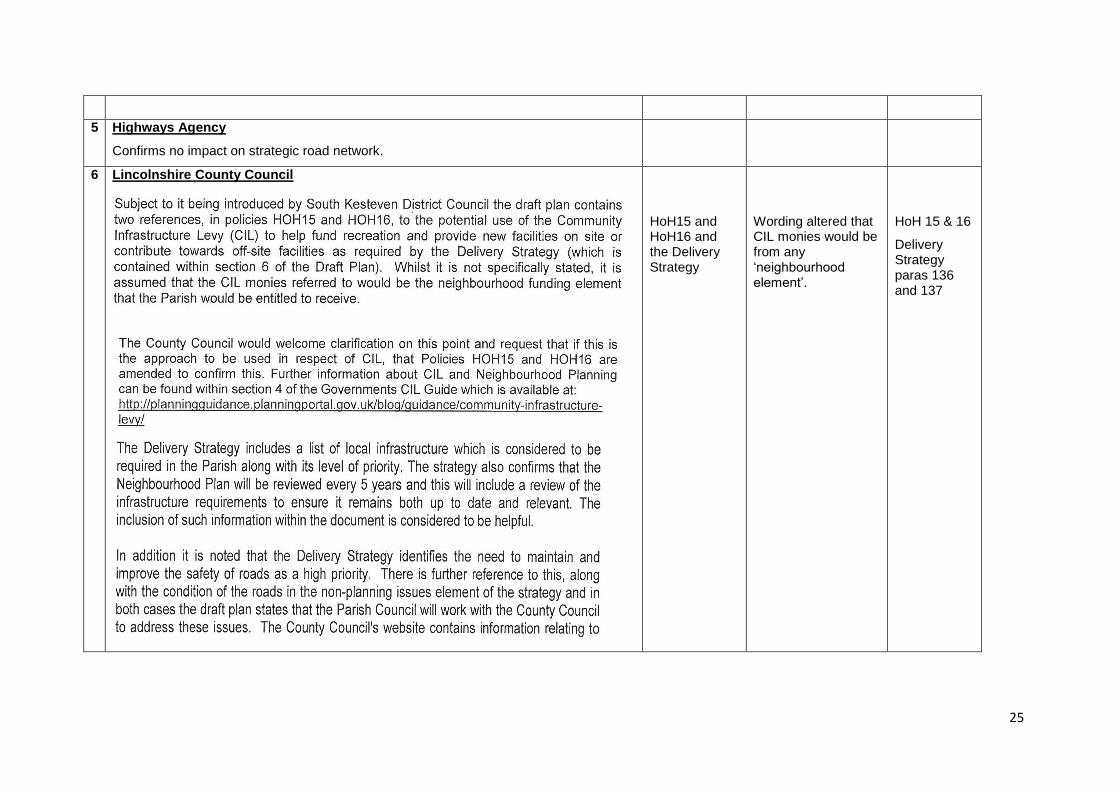
6 Lincolnshire County Council
HoH15 and HoH16 and the Delivery Strategy
Wording altered that CIL monies would be from any „neighbourhood element‟.
HoH 15 & 16
Delivery Strategy paras 136 and 137
26
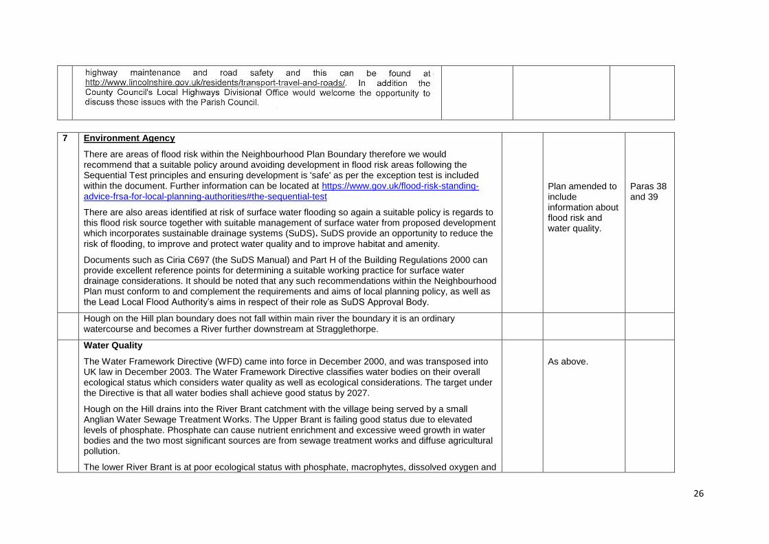
7 Environment Agency
There are areas of flood risk within the Neighbourhood Plan Boundary therefore we would recommend that a suitable policy around avoiding development in flood risk areas following the Sequential Test principles and ensuring development is 'safe' as per the exception test is included within the document. Further information can be located at https://www.gov.uk/flood-risk-standing-advice-frsa-for-local-planning-authorities#the-sequential-test
There are also areas identified at risk of surface water flooding so again a suitable policy is regards to this flood risk source together with suitable management of surface water from proposed development which incorporates sustainable drainage systems (SuDS). SuDS provide an opportunity to reduce the risk of flooding, to improve and protect water quality and to improve habitat and amenity.
Documents such as Ciria C697 (the SuDS Manual) and Part H of the Building Regulations 2000 can provide excellent reference points for determining a suitable working practice for surface water drainage considerations. It should be noted that any such recommendations within the Neighbourhood Plan must conform to and complement the requirements and aims of local planning policy, as well as the Lead Local Flood Authority‟s aims in respect of their role as SuDS Approval Body.
Plan amended to include information about flood risk and water quality.
Paras 38 and 39
Hough on the Hill plan boundary does not fall within main river the boundary it is an ordinary watercourse and becomes a River further downstream at Stragglethorpe.
Water Quality
The Water Framework Directive (WFD) came into force in December 2000, and was transposed into UK law in December 2003. The Water Framework Directive classifies water bodies on their overall ecological status which considers water quality as well as ecological considerations. The target under the Directive is that all water bodies shall achieve good status by 2027.
Hough on the Hill drains into the River Brant catchment with the village being served by a small Anglian Water Sewage Treatment Works. The Upper Brant is failing good status due to elevated levels of phosphate. Phosphate can cause nutrient enrichment and excessive weed growth in water bodies and the two most significant sources are from sewage treatment works and diffuse agricultural pollution.
The lower River Brant is at poor ecological status with phosphate, macrophytes, dissolved oxygen and
As above.

27
invertebrates all failing to achieve good ecological status.
The first principle of the WFD is to prevent deterioration in aquatic ecosystems. 'No deterioration' requires that a water body does not deteriorate from its current ecological or chemical classification, and applies to individual pollutants within a water body. Any future development within the Neighbourhood Planning boundary should be undertaken in a way which does not cause deterioration of the River Brant, Honington Beck or Sand Beck.
Elevated Phosphate levels can result from diffuse pollution (both urban and rural) and from sewage effluents from both private and public (Water Company) sewage treatment systems. In order to prevent deterioration in water quality, any proposals for development within the local plan area should fully consider how foul flows will be collected and treated.
For any proposals within the sewered area of Hough-on-the-Hill itself, the water company should be consulted to ensure that the infrastructure for collection and treatment of sewage has sufficient capacity to accommodate additional flows.
Any new private systems should be appropriately located, designed, installed and maintained. Further information relating to small private sewage discharges can be found at https://www.gov.uk/permits-you-need-for-septic-tanks/overview and in the Codes of Practise available on the British Water website http://www.britishwater.co.uk/publications/Publications_and_Technical_Guides.aspx
Appropriate use of SuDS (Sustainable urban drainage systems) in new developments can also help to reduce the impacts of diffuse pollution on watercourses.
The Witham Partnership has been set up with the aim of improving the water environment across the Witham catchment. The partnership aims to involve local organisations and communities to help decide on the key water issues and best way to address those following Department Environment Food and Rural Affairs (DEFRAs) catchment based approach principles. The hosts for the Witham partnership are the Lincolnshire Rivers Trust. The Trust engages with local people, communities and authorities to carry out monitoring and improvement projects and for more information please go to http://lincsrivers.co.uk/
Hough-on-the-Hill is within the area covered by the South Kesteven Water Cycle Strategy. Further information is available on South Kesteven District Council‟s website http://www.southkesteven.gov.uk/index.aspx?articleid=2113
Water Resources
There are four water abstraction licences in the Neighbourhood Plan area, these include licences that allow abstraction for storage in reservoirs and direct abstraction.
In addition to local renewable and/or low carbon approaches to generating energy and initiatives
Reference now made to water
Design Guidance
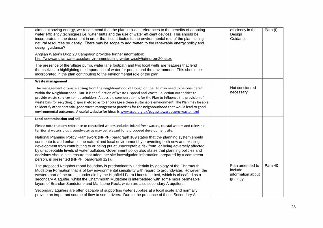
28
aimed at saving energy, we recommend that the plan includes references to the benefits of adopting water efficiency techniques i.e. water butts and the use of water efficient devices. This should be incorporated in the document in order that it contributes to the environmental role of the plan, „using natural resources prudently‟. There may be scope to add „water‟ to the renewable energy policy and design guidance?
Anglian Water‟s Drop 20 Campaign provides further information: http://www.anglianwater.co.uk/environment/using-water-wisely/join-drop-20.aspx
The presence of the village pump, water lane footpath and two local wells are features that lend themselves to highlighting the importance of water for people and the environment. This should be incorporated in the plan contributing to the environmental role of the plan.
efficiency in the Design Guidance.
Para (f)
Waste management
The management of waste arising from the neighbourhood of Hough on the Hill may need to be considered within the Neighbourhood Plan. It is the function of Waste Disposal and Waste Collection Authorities to provide waste services to householders. A possible consideration is for the Plan to influence the provision of waste bins for recycling, disposal etc so as to encourage a clean sustainable environment. The Plan may be able to identify other potential good waste management practises for the neighbourhood that would lead to good environmental outcomes. A useful website for ideas is www.tcpa.org.uk/pages/towards-zero-waste.html
Not considered necessary.
Land contamination and soil
Please note that any reference to controlled waters includes inland freshwaters, coastal waters and relevant territorial waters plus groundwater as may be relevant for a proposed development site.
National Planning Policy Framework (NPPF) paragraph 109 states that the planning system should contribute to and enhance the natural and local environment by preventing both new and existing development from contributing to or being put at unacceptable risk from, or being adversely affected by unacceptable levels of water pollution. Government policy also states that planning policies and decisions should also ensure that adequate site investigation information, prepared by a competent person, is presented (NPPF, paragraph 121).
The proposed Neighbourhood boundary is predominantly underlain by geology of the Charmouth Mudstone Formation that is of low environmental sensitivity with regard to groundwater. However, the western part of the area is underlain by the Highfield Farm Limestone bed, which is classified as a secondary A aquifer, whilst the Chammouth Mudstone is interbedded with some more permeable layers of Brandon Sandstone and Marlstone Rock, which are also secondary A aquifers.
Secondary aquifers are often capable of supporting water supplies at a local scale and normally provide an important source of flow to some rivers. Due to the presence of these Secondary A
Plan amended to include information about geology.
Para 40
29
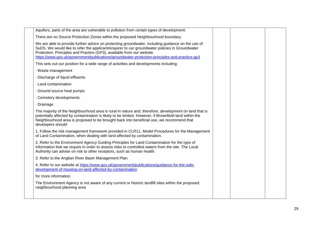
Aquifers, parts of the area are vulnerable to pollution from certain types of development.
There are no Source Protection Zones within the proposed Neighbourhood boundary.
We are able to provide further advice on protecting groundwater, including guidance on the use of SuDS. We would like to refer the applicant/enquirer to our groundwater policies in Groundwater Protection: Principles and Practice (GP3), available from our website. https://www.gov.uk/government/publications/groundwater-protection-principles-and-practice-gp3
This sets out our position for a wide range of activities and developments including:
· Waste management
· Discharge of liquid effluents
· Land contamination
· Ground source heat pumps
· Cemetery developments
· Drainage
The majority of the Neighbourhood area is rural in nature and, therefore, development on land that is potentially affected by contamination is likely to be limited. However, if Brownfield land within the Neighbourhood area is proposed to be brought back into beneficial use, we recommend that developers should:
1. Follow the risk management framework provided in CLR11, Model Procedures for the Management of Land Contamination, when dealing with land affected by contamination.
2. Refer to the Environment Agency Guiding Principles for Land Contamination for the type of information that we require in order to assess risks to controlled waters from the site. The Local Authority can advise on risk to other receptors, such as human health.
3. Refer to the Anglian River Basin Management Plan.
4. Refer to our website at https://www.gov.uk/government/publications/guidance-for-the-safe-development-of-housing-on-land-affected-by-contamination
for more information.
The Environment Agency is not aware of any current or historic landfill sites within the proposed neighbourhood planning area
30
Mitigate and adapt to climate change
In April 2012 we took on full responsibility for the governments Climate Ready support service which provides advice and support to businesses, the public sector and other organisations on adapting to climate change. The aim is to ensure businesses and services assess how they will be impacted by a changing climate so that they are both resilient and can thrive in the future. The Climate Ready pages of our website (http://webarchive.nationalarchives.gov.uk/20140328084622/http://www.environment-agency.gov.uk/research/137557.aspx) provide information including guidance on carrying out impact assessments and evaluating adaptation strategies.
The UK Green Building Council has also published a series of documents to help Local Authorities and developers to understand sustainability issues. These documents are available on their website at: www.ukgbc.org/content/advice-planners-and-developers
Noted
Net Gains for Nature
Landscaping proposals should demonstrate that thought has been given to maximising potential ecological enhancement. Paragraph 9 of the NPPF sets out that planning should seek positive improvements and includes an aim to move from a net loss of biodiversity to achieving net gains for nature in line with the Natural Environment White Paper (2011). In determining planning applications Local Authorities are asked to conserve and enhance biodiversity and encourage opportunities to incorporate biodiversity in and around developments (Para.118). This presents an opportunity to provide multi-functional benefits - providing open space for residents, sustainable transport links, wildlife/ecological value, climate change resilience, improved water quality and flood risk management.
Green Infrastructure, defined as a network of new and existing multi-functional green space and features, such as ecological corridors or other appropriate planting, should therefore be considered as part of the development. Such measures can provide the range of benefits outlined above, including for example providing shade to the built environment to reduce overheating, and intercepting rainfall and reducing flood risk. But there is evidence that the inclusion of such features can also provide further economic benefits, such as encouraging inward investment, increasing property values and increasing visitor spending in an area. More information on this and Green Infrastructure in general is available on the Natural England web pages: www.naturalengland.org.uk/ourwork/planningdevelopment/greeninfrastructure/default.aspx
Incorporating green and/or brown roofs and walls can be a particularly effective measure. They provide valuable urban habitats, increased energy efficiency of buildings and attenuation of rain water. Research from the journal „Environmental Science and Technology‟ claims that green walls deliver cleaner air at street level where most people are exposed to the highest pollution. They can also add to an attractive street scene if designed well – a good example of this is the Transport for London
Noted
31
Green Wall near Blackfriars station.
Environmental permitting
The Plan must have a consideration for pollution prevention measures that ensure that the environment is protected. We recommend that a review of the Environment Agency's Pollution Prevention Guidelines is carried out to identify the types of situations and measures that need to be considered. These Guidelines are at https://www.gov.uk/government/collections/pollution-prevention-guidance-ppg
8 Anglian Water: No comment
9 Upper Witham Internal Drainage Board
Some of the lower parts of the area of interest fall within the Upper Witham Internal Drainage Board‟s District, see the attached plan. More information about the Board can be found on the website „upperwitham-idb.gov.uk „. Most of the existing property has been built on higher ground outside the District although there are a number of properties on Brandon Road that are within the Board‟s District in an area that can be considered at risk of flooding.
It should also be noted that there has been some flooding/ground water issues in the village of Brandon.
The area of interest is situated in an area where the watercourses are unable to accept any increase in the rates of discharge; therefore any development must prove the existence of a surface water drainage route and provide adequate proposals to make certain that flood risk is not increased elsewhere as a result of any proposed development.
It is suggested that the Neighbourhood Plan should support the idea of sustainable drainage and that any proposed development should be in accordance with National and Regional Flood Risk assessments and Management plans.
No new development should be allowed to be built within flood plain. The „Flood Maps‟ on the Environment Agency website provides information on areas at risk, information can be found by searching „EA flood maps‟. Also risk from surface water flooding should also be considered, information can also be found on the Environment Agency website. It can be found by search using „EA surface water flood map‟
Under the terms of the Land Drainage Act. 1991 and the Board's Byelaws, the prior written consent of the Board is required for any proposed works or structures in, under, over or within 6 metres of the top of the bank of any watercourse within the District. This is independent of the Planning Process.
Also under the provisions of the Flood and Water Management Act 2010, and the Land Drainage Act. 1991, the prior written consent of the Lead Local Flood Authority (Lincolnshire County Council) is
Plan amended to include information about flood risk and water quality.
Paras 38 and 39
32
required for any proposed works or structures in any watercourse outside those designated main rivers and Internal Drainage Districts. In this area the Board acts as Agents for the Lead Local Flood Authority and as such any works, permanent or temporary, in any ditch, dyke or other such watercourse will require consent from the Board.
10 Resident
We wish to register that we do NOT support any property / residential development in the village of Hough on the Hill nor parish, including sustainable housing, other than converting existing buildings. We FULLY endorse the local Character Assessment contained within the Neighbourhood Plan.
Noted.
11 Farmer & Landowner
Need to reflect the contribution of local farmers to the landscape and wildlife.
New section added to reflect contribution of local farmers to landscape and wildlife.
Paras 25 and 26
Need to recognise the needs of working farm, in terms of :
Heavy/slow traffic
Noted.
33
Movement of animals
Modernisation of buildings
Minimising (direct or indirect) bureaucracy
Need to be positive wherever possible.
I don‟t think they found any evidence in recent excavations at Temple Hill Para 10
Wording amended
Para 10
The Quakers no longer farm at Brandon. Para Wording Para 16
34
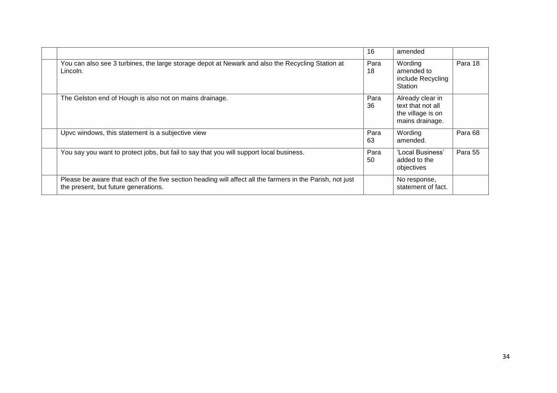
16 amended
You can also see 3 turbines, the large storage depot at Newark and also the Recycling Station at Lincoln.
Para 18
Wording amended to include Recycling Station
Para 18
The Gelston end of Hough is also not on mains drainage. Para 36
Already clear in text that not all the village is on mains drainage.
Upvc windows, this statement is a subjective view Para 63
Wording amended.
Para 68
You say you want to protect jobs, but fail to say that you will support local business. Para 50
„Local Business‟ added to the objectives
Para 55
Please be aware that each of the five section heading will affect all the farmers in the Parish, not just the present, but future generations.
No response, statement of fact.