Embed Size (px)
Citation preview

Published on INSPIRE (https://inspire.ec.europa.eu)
Home > Romania - 2019: Country Fiche
Table of Contents
IntroductionState of Play
CoordinationFunctioning and coordination of the infrastructureUsage of the infrastructure for spatial informationData Sharing ArrangementsCosts and Benefits
Key Facts and Figures. Identification of spatial data with relevance to the environment (step 1)Documentation of the data (metadata) (step 2)Accessibility of the data through digital services (step 3)Interoperability of spatial data sets (step 4)
Introduction
The INSPIRE Directive sets the minimum conditions for interoperable sharing and exchange of spatial data across Europe as part of a largerEuropean Interoperability Framework and the e-Government Action Plan that contributes to the Digital Single Market Agenda. Article 21 ofINSPIRE Directive defines the basic principles for monitoring and reporting. More detailed implementing rules regarding INSPIRE monitoringand reporting have been adopted as COMMISSION DECISION regarding INSPIRE monitoring and reporting on the 5th of June 2009.
This country fiche highlights the progress in the various areas of INSPIRE implementation and presents an outlook of planned actions forfurther improvement of the INSPIRE implementation. The country fiche includes information until May 2019 as an update of the informationacquired through:
member states update,
monitoring report in May 2019.
State Of Play
A high-level view on the governance, use and impact of the INSPIRE Directive in Romania. More detailed information is available on theINSPIRE knowledge base.
Coordination
Name of Public Authority: National Agency for Cadastre and Land RegistrationPostal Address: No. 202A Splaiul Independenței, 1st floor, sector 6, Bucharest
Contact Email: Telephone Number: +40 21 317 73 39Telefax Number: +40 21 316 52 24National INSPIRE Website: http://www.ancpi.roMIG Contacts:
MIG T Contacts:
National Contact Point
Click to email
Contact Person: Marilena Daniela DoncutaEmail: [email protected] Person: Ioan - Laurentiu RaileanuEmail: [email protected]
Contact Person: Simona Daniela BuneaEmail: [email protected] Person: Gabriela DraganEmail: [email protected]

Coordination Structure & Progress: The normative act transposing the INSPIRE Directive - the Government Ordinance no. 4/2010 on the establishment of the NationalInfrastructure for Spatial Information in Romania - was republished in 2014. It provides the legal framework for the establishment of theCouncil for National Infrastructure of Spatial Information (INIS Council), which has a coordinating role in the implementation of theINSPIRE Directive and consists of representatives of 23 public authorities.
INIS Council presidency is ensured by the National Agency for Cadastre and Land Registration (ANCPI), and the vice-presidency isensured by the Ministry of Environment. In its activity, the INIS Council is assisted by 4 expert groups, as shown above.
ProgressDuring the reported period, the EU Pilot File 4899/13/ENV was closed following the approval of the subsequent normative acts oftransposing legislation.Decision no. 1/2016 of the INIS Council on free access of public authorities in Romania and community institutions to spatial dataand services has been adopted.In order to fulfill their responsibilities, the public authorities have set up specialized departments with attributions in this respect.Expert groups continued their specific activity.As public authority responsible for theme III. 6, ANCPI has drawn up the Technical Norms for the achievement of the data setsrelated to theme III.6 Utility and governmental services, sub-domain Public utility networks. The normative act was approved bythe Order of ANCPI General Director no. 1523/2017. Regional operators holding spatial data achieved within European fundedprojects, process the data in order to comply with the Technical Norms and upload them to the communication platform (basedon user and password) set up by ANCPI for this purpose. The spatial data services of the existing spatial data sets will beachieved by ANCPI in accordance with the INSPIRE specifications.Information is available through the INIS Geoportal of Romania www.geoportal.gov.ro.
Functioning and coordination of the infrastructure
The GeoCatalog, representing the INIS Geoportal component (http://geoportal.gov.ro/Geocatalog), enables the collection andmanagement of metadata coming from geospatial data managers.The Geoportalul of the Ministry of National Defence can be accessed at: https:\\inspire.geomil.ro.RO-RISK Portal for Disaster Assessment at national level can be accessed through Internet Explorer at http://gis.ro-risk.ro/geoportal/.The portal provides access for all stakeholders to data related to items exposed at risks and / or vulnerable, hazard and risk maps atthe level of Romania.The spatial data specific to geology field can be accessed through the geoportal of the Geological Institute of Romaniahttp://www.igr.ro/1GE/geoportaligr/index.php.At the web address https://gis.cestrin.ro/arcgis/home/, it was created the spatial data portal, required for publication of view anddownload services and which requires authentication.INIS objectives promote the principle: single collection, multiple use.The INIS Council encourages partnerships and cooperation between public institutions and public authorities regarding exchange ofspatial data.
Usage of the infrastructure for spatial information
All public authorities in Romania download from the INIS Geoportal, the INSPIRE data set related to theme "Administrative Units", anduse it as reference data.In August 2017, the European Commission, on the basis of Commission Regulation (EU) no 268/2010 as regards the access to spatialdata sets and services of the Member States by Community institutions and bodies under harmonized conditions, requested access toorthophoto services needed for an analysis on land cover, agriculture and forests at European level. ANCPI and the GeospatialDefense Information Agency "General Division Constantin Barozzi" (AIGA) have approved access to services for orthophoto they own.Geospatial information on orthoimagery, Digital Terrain Model and Geographical Names were also provided through the downloadservices available within the INIS Geoportal – Ministry of National Defence Component.Solutions to ensure restricted access to special data sets (eg the National System for Gas Transport) have been analyzed.The National Agency for Environment Protection (ANPM) launched in March 2018 the tender procedure for "Maintenance services,HW/SW infrastructure upgrade, extension/development software for integrated subsystems, assistance and technical support for theIntegrated Environment System, evolutionary maintenance, installation, configuration, testing and related services for other NAEP IT &C infrastructure requirements and upgrades, in which it is requested the adaptation of the integrated register to the requirements of theEU Registry on Industrial Sites.Romanian Protected Areas Dataset has been updated following the designation of new sites of community importance; this data setcontains information from 4 themes: I3, I.4, I.9 and III.17. Compliant view and download services have been established for this dataset.During the reported period, download and view services were created for spatial data sets related to the themes:
I.7 Transport network – road network

I.8 HydrographyI.9 Protected sitesII.4 GeologyIII.7 Environmental monitoring facilitiesIII.11 Area management/restriction/regulation zones and reporting unitsIII.12 Natural risk zones
Currently, Romania provides access to spatial data sets through 23 download services and 27 view services. Of these, 10 are prioritydata sets.
Data sharing arrangements
Collaboration agreements between public authorities have focused on the exchange of geospatial data.INIS ensures a uniform framework for data sharing and public access to data.ANCPI has signed data sharing agreements with public institutions in Romania and Bulgaria, Hungary.The Ministry of National Defense through AIGA has concluded a series of data sharing agreements with public institutions in order tomake available free of charge the orthographic images achieved between 2010-2013 and 2013-2017. Thus, 46 TerritorialAdministrative Units, 5 County Councils and Central Public Authorities had access to these products.The Special Telecommunications Service (STS) continued to use spatial data from ANCPI and AIGA in emergency situations, thecommand and control centres, critical infrastructure and ‘112’ Single emergency call number
Costs and benefits
Not all public authorities involved in setting up and updating INIS provided a detailed list of the costs for each activity for the period2016-2018.ANCPI has signed at the end of 2018 a 4 year framework service contract for view and download services for the data sets related tothemes Addresses, Buildings and Utility and governmental services.The Ministry of Agriculture and Rural Development through the Payments and Intervention Agency in Agriculture prepared the launch ofthe procurement procedure for the implementation of compliant services for the spatial data from themes III.9 and II.3.The Ministry of Regional Development and Public Administration allocated an amount of 11,878,700 Euro (2016-2018) for theelaboration and / or completion of urban planning documentation within the annual Program for the elaboration and / or updating of thegeneral urban plans and of the local urban planning regulations; these documentation will form the basis of the spatial data sets oftheme III.4 Land use.The National Meteorological Administration has contracted training services for the training of specialists involved in the implementationof the spatial data structure compliant to INSPIRE. The value of the training services was 12,500 Euro.ANCPI is the public authority responsible for the implementation of "Cadastral Parcels" theme. The data set and view and downloadservices compliant with this theme have been achieved but cannot be discovered through the discovery service. The amounts collectedfrom the provision of information on cadastral parcels contribute to the financing of the National Cadastre and Land Book Programe2015-2023. The purpose of this program is to systematically register the real estate in the integrated cadastre and land book system, E-terra, across the country.The Ministry of National Defense / AIGA has acquired technical support and Geoportal software upgrade and storage capacityextension to a total value of 153,446 Euro.INIS contributes to improving and reducing the cost of spatial information.Interoperability of spatial data is necessary to implement the projects of central and local public authorities.Significant beneficiaries of spatial data are from both public administration and business environment (real estate investors, wind parkdevelopers) and the general public.
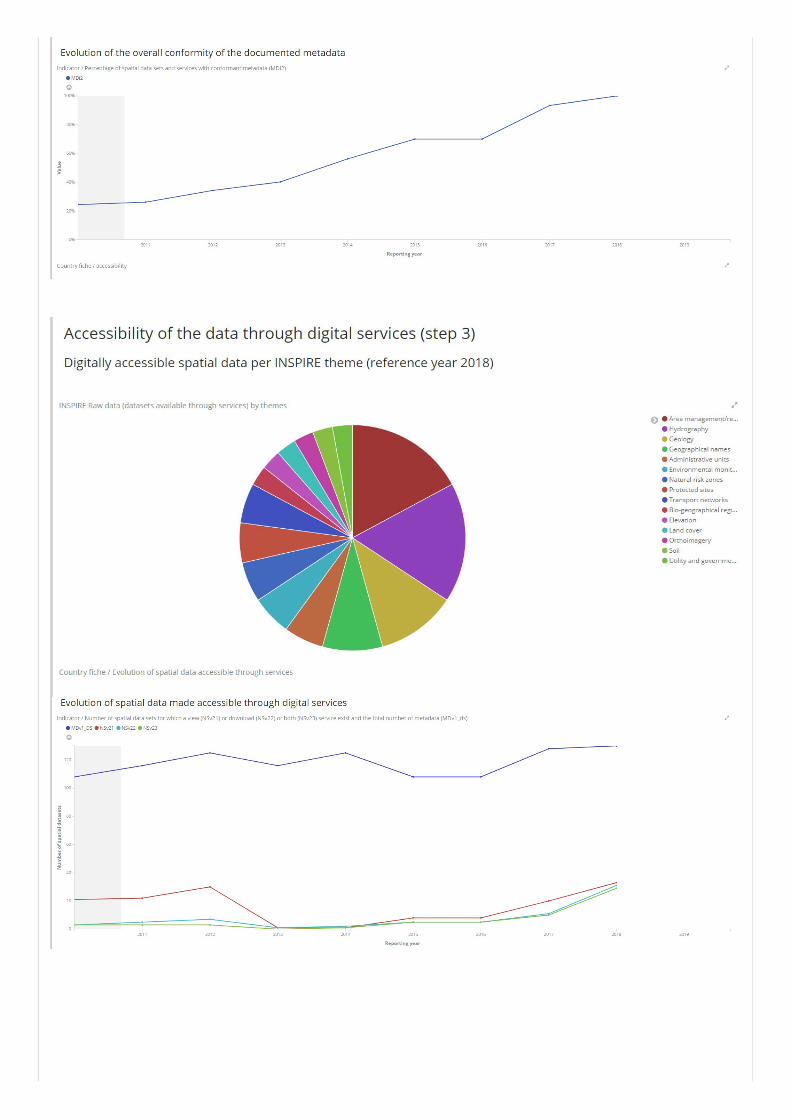
Key facts and figures
In addition to the above mentioned issues, the implementation of INSPIRE Directive requires Member States to take four main steps inrelation to management of spatial datasets which fall under the Directive:
Step 1: Identify spatial datasetsStep 2: Document these datasets (metadata)Step 3: Provide services for identified spatial datasets (discovery, view, download)Step 4: Make spatial datasets interoperable by aligning them with the common data models.
The key facts and figures presented in this country fiche are based on the information provided by Romania on the INSPIRE dashboard. Theprovided statistics is not reflecting the data available on INSPIRE geoportal. The INSPIRE geoportal is updated on a regular and ongoingbasis, whilst the INSPIRE dashboard is typically updated after every reporting round, on a yearly basis.
The conformity of the implementation is assessed against the full set of legal specifications set out by the Directive and the ImplementingRules and the commonly agreed good practices set out by the technical guidelines.
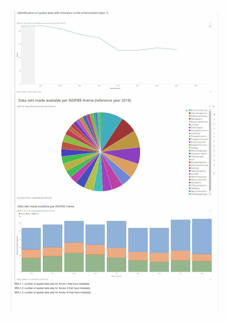
MDv1.1: number of spatial data sets for Annex I that have metadata
MDv1.2: number of spatial data sets for Annex II that have metadata
MDv1.3: number of spatial data sets for Annex III that have metadata
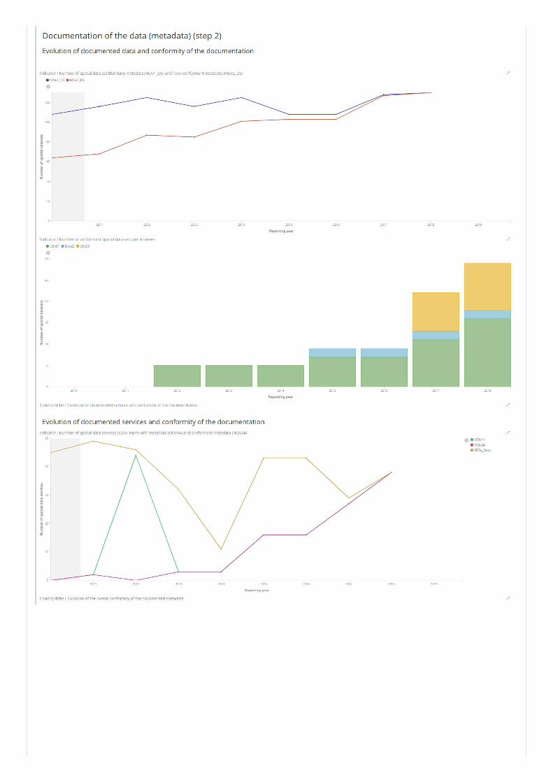

DSv2.1: number of conformant spatial data sets with conformant metadata for Annex I
DSv2.2: number of conformant spatial data sets with conformant metadata for Annex II
DSv2.3: number of conformant spatial data sets with conformant metadata for Annex III