Embed Size (px)
Citation preview

STATE OF MAINE
DEPARTMENT OF ENVIRONMENTAL PROTECTION
Stormwater Management Law
38 M.R.S.A. § 420-D
PERMIT APPLICATION
Bureau of Land and Water Quality March 2014
No. DEPLW052-H2014

Introduction
Maine's economy relies on clean lakes, rivers, and coastal waters, and many of Maine's communities use
these water resources to supply drinking water. Unfortunately, many of these water resources are
impaired or threatened by activities within their watersheds.
These resources are affected by rainwater and snowmelt that flow over disturbed areas, parking lots,
gravel and paved roads, lawns, and other areas where people have changed the natural cover and
regraded the land. This stormwater picks up soil, residues from gas and oil, nutrients, heavy metals, and
bacteria and other pathogens. Without proper treatment, the stormwater deposits these pollutants in our
lakes, streams, and coastal waterbodies. Replacement of woods and fields by impervious areas such as
pavement, buildings, and hard-packed gravel roads also increases the volume of stormwater leaving a
site. This increase in flow can cause property damage, erode stream banks, scour stream beds, harm
habitat, and add to the pollution of lakes, streams, and coastal waters.
In Maine, stormwater pollution has already affected over 200 lakes and several hundred miles of
streams; it has also contributed to the closure of many acres of clam flats. In addition to the effects on
business from reduced tourism, property damage, and decreasing coldwater fish populations, a decline in
water quality affects the value of shorefront property and the cost of treating drinking water, resulting in
higher taxes and fees for all residents and businesses. Regions of the state have suffered significant
economic losses due to degradation of waterbodies.
Maine's Stormwater Management Law requires some new projects to provide stormwater management
as part of their design. The Department of Environmental Protection reviews these stormwater
management systems to determine whether they will meet standards in the law to minimize the impacts
of stormwater on private and public property.

Table of Contents
Page
Flowcharts and Statewide Map
Flowchart for Chapter 500 Standards, Stormwater Management Law ........... i
Flowchart for General Licensing, Division of Land Resource Regulation .... ii
Statewide Map Identifying Regional Office Boundaries................... ……...iii
Section 1. Information Concerning the Application Process ......................... 1
A. Pre-application meeting ........................................................................... 1
B. Public notice ............................................................................................. 1
C. Assistance and materials........................................................................... 2
D. The application ........................................................................................ 3
E. Processing................................................................................................. 4
F. Final action and appeal ............................................................................. 4
Section 2. Forms (including application form and instructions) .................... 6
A. Application form instructions ................................................................... 6
B. Application form and signature/certification page ................................... 9
C. Public notice form .................................................................................. 12
D. Public notice filing and certification ...................................................... 13
E. Fee worksheet ......................................................................................... 14
F. Submittal checklist .................................................................................. 15
G. Contractor certification .......................................................................... 16
H. Notice of Termination ............................................................................ 17
I. Soil and Water Conservation District optional review form 18
Section 3. Submissions and pre-application meetings .................................. 19
A. Design requirements ............................................................................... 19
B. Basic standards submissions .................................................................. 19
C. General standards submissions ............................................................... 21
D. Flooding standard submissions .............................................................. 24
E. Submissions for other standards that apply to the project ...................... 24
F. Pre-application request form 25
Section 4. Draft Deed Restriction Language ................................................. 27
A Forested buffer, limited disturbance ....................................................... 27
B. Forested buffer, no disturbance .............................................................. 30
C. Meadow buffer ....................................................................................... 33

i

FLOWCHART for GENERAL LICENSING
DEP’s DIVISION OF LAND RESOURCE REGULATION
ii
Customer Contact …Direct call to staff
On-call staff contact
Field determination
Enforcement
Internet
Provide appropriate application materials,
regulations, fee information, etc.
Pre-application meeting required or
requested via letter to Licensing
Coordinator, Supervisor or staff. Request
logged. Project Manager assigned.
Meeting held. .
No pre-application
meeting required or
requested
Submittal of application
Log-in of application into Application
Tracking System (ATS) by Data
Management Unit staff (1day)
Licensing Coordinator or Supervisor
assigns application to Project Manager
(within1 day)
Project Manager reviews application
for completeness within 15 working
days of submittal.
Return as incomplete with letter
explaining deficiencies. Fee
returned. Contact applicant to address
minor deficiencies; hold up
to 14 working days from
submittal for additional
information. Application complete. Accept
application for processing; send letter
to applicant.
If appropriate, Project Manager sends
application to technical staff for
review. (Approximately 30 to 45 days)
If required, requests for additional
information sent to applicant based on
technical reviews. Re- review.
Project manager drafts order for review
by Licensing Coordinator and/or
Licensing Supervisor. Edits
incorporated.
Draft reviewed & initialed by Division
Director & Bureau Director; Signed
Order issued, usually within 2 to 3
days of supervisor review.
A public hearing &/or Board of
Environmental Protection
jurisdiction may be requested within
20 days of acceptance.
See SOP #DEPLW0619-A2003.
Department decision may be
appealed within 30 days of the date
filed with the Board of
Environmental Protection.
See SOP #DEPLW0580-A2003

iii

1
Section 1. Information Concerning the Application Process
This document is to be used when applying for a permit pursuant to the Stormwater Management Law, 38 M.R.S.A. § 420-D. An applicant may apply for a transfer or minor revision of an individual
stormwater management project. There are separate forms to be used for stormwater transfer or minor
revision applications. An individual stormwater permit may be extended one time using the stormwater
Permit by Rule (PBR) notification form provided that the approved project has not begun and the permit
has not expired. A permit may only be extended once using a stormwater PBR. A. Pre-application meetings. A pre-application meeting is required for all new stormwater
applications. This meeting provides an opportunity for the applicant to meet with department staff
who will review the application. The purpose of the meeting is to help the applicant understand the
application review process, identify particular areas of concern and exchange information before
commitment to a final design. The requirement for this meeting may be waived upon mutual
agreement of the department and the applicant, however the department has noted that applications
for which a pre-application meeting has been held are generally more complete and less likely to be
returned as incomplete for processing than applications for which no pre-application meeting was
held. There is no charge to the applicant for this meeting.
(1) Scheduling. To schedule a pre-application meeting, send a written request, including the
Stormwater Pre-application Request Form and attachments, to the DEP regional office serving the
town where the project is located. A state map identifying regional office boundaries is located
on page iii. Exception: A pre-application request for a project located in a town served by the
Northern Maine Regional Office should be sent to the Eastern Maine Regional Office in Bangor.
To confirm which office serves the town where the project is proposed, call any DEP office.
Central Maine Regional Office
Bureau of Land and Water Quality
17 State House Station
Augusta, ME 04333
Tel: (207) 287-3901 or
1-800-452-1942
Southern Maine Regional Office
Bureau of Land and Water Quality
312 Canco Road
Portland, ME 04103
Tel: (207) 822-6300 or
1-888-769-1036
Eastern Maine Regional Office
Bureau of Land and Water Quality
106 Hogan Road
Bangor, ME 04401
(207) 941-4570 or
1-888-769-1137
(2) Pre-application submissions. The written request for a pre-application meeting should include a
phone number where the applicant or agent may be reached during the day; a brief description of
the project; the approximate acreage of developed area and/or disturbed area, and impervious
area; the location of project shown on a United States Geological Survey seven-and-one-half-
minute topographic map or other regional map; and a plan or preliminary sketch of the project.
Two copies of the pre-application materials need to be submitted with your request.
B. Public notice. An applicant for a Stormwater permit is required to provide public notice of their
application. A blank copy of the notice form is in Section 2 (Form B) of this publication. A copy of this
form or one containing identical information must be used to notify abutters, municipal officials, and
local newspapers. The rules concerning notice are contained in "Rules Concerning Processing of
Applications and Other Administrative Matters", 06-096 CMR 2 (referred to as "Chapter 2").
(1) Newspaper. Publish the public notice once in a newspaper circulated in the area where the
project is located. The public notice must appear in the newspaper within 30 days prior to filing a

2
new or amendment application, or a resubmitted application returned as incomplete pursuant to
Chapter 2.
(2) Abutting property owners. Provide a copy of the public notice to the owners of abutting property.
Their names and addresses can be obtained from town tax maps or local officials. Abutters must
receive public notice within 30 days prior to filing a new or amended stormwater application, or a
resubmitted application returned as incomplete pursuant to Chapter 2. For the purposes of this
application, an abutting property owner means any person who owns property that is BOTH (1)
adjoining and (2) within 1 mile of the delineated project boundary, including owners of property
directly across a public or private right of way.
(3) Municipal or plantation office. Provide a copy of the public notice together with a duplicate of
the entire application to the appropriate town or city clerk. The notice must be received within 30
days prior to filing a new or amendment application, or a resubmitted application returned as
incomplete pursuant to Chapter 2.
C. Assistance and materials. Department staff are available to answer questions. Direct questions
concerning application requirements to the project manager or, if a project manager has not yet been
assigned, to the Division of Land Resource Regulation's Licensing Coordinators in Augusta
(287-3901) or Portland (822-6300). The applicant should obtain copies of the Stormwater
Management Law, and the Stormwater Management Rules before compiling an application. The
following list includes other materials that may also be helpful.
Maine Erosion and Sediment Control Handbook for Construction: Best Management Practices.
Available from Cumberland County Soil and Water Conservation District, 35 Main Street,
Windham, Maine 04062 (892-4700), or on the DEP website at
http://www.maine.gov/dep/blwq/docstand/escbmps/index.htm
Natural Resources Protection Act (NRPA), 38 M.R.S.A. §§ 480-A et. seq. Available from any DEP
office or on the DEP website at
http://www.maine.gov/dep/land/nrpa/index.html
Phosphorus Control in Lake Watersheds: A Technical Guide to Evaluating New Development
(revised 1992). Available from the DEP office in Augusta (287-3901).
Rules Concerning Processing of Applications, 06-096 CMR 2. Available from any DEP office or on
the DEP website at
http://www.maine.gov/sos/cec/rules/06/096/096c002.doc These rules include requirements for notice,
"title, right or interest", public access to information, hearings, and other subjects.
Stormwater Management for Maine: Best Management Practices (January, 2006). Available from
the Nonpoint Source Training and Resource Center, at the DEP office in Augusta (215-9237) or
on the DEP website at
http://www.maine.gov/dep/land/stormwater/stormwaterbmps/
Stormwater Management Law, 38 M.R.S.A. § 420-D. Available from any DEP office or on the DEP's
web site at
http://www.maine.gov/dep/land/stormwater/storm.html

3
Stormwater Management Rules, Chapters 500 and 502. Available from any DEP office or on the
DEP's web site at http://www.maine.gov/dep/land/stormwater/storm.html
Maine General Permit - Construction Activity, Maine Pollutant Discharge Elimination System
(MPDES). Available from any DEP office or on the DEP website at
http://www.maine.gov/dep/land/stormwater/construction.html
D. The application. The application submitted to the department should include completed forms (see
Section 2 for blank forms), and applicable submissions described in Section 3 of this publication. The
submissions necessary to demonstrate that the standards will be met may vary depending upon the
applicable standards, project location, site conditions, and project design, including proposed BMPs. In
addition, if the applicant is a registered corporation, provide either a Certificate of Good Standing
(available from the Secretary of State) or a statement signed by a corporate officer affirming that the
corporation is in good standing. Any questions concerning which submission requirements apply can be
addressed as part of the pre-application meeting.
(1) Organization. Organize the application in the following manner.
(a) Place completed copies of the forms, on pages 9-14, at the front of the application. Also
include information demonstrating that the applicant has sufficient title, right or interest in all
of the property proposed for use, such as a copy of the deed, a lease, an easement, an option to
buy, or a statement concerning the ability and intent to use eminent domain.
(b) Organize the submissions in the order followed in Section 3 of this publication. Divide the
subsections with tabs.
(c) Provide two (2) copies of the application and any attachments to the department. Provide
one additional copy if proposing to use infiltration. Other additional copies may be
required by the project manager at a later date.
(2) Combining figures. Plans, drawings and maps may be combined as long as all details are clearly
shown. Adhere to the following specifications, unless variations are specifically approved prior
to submission of the application:
(a) Sheet size 24" X 36";
(b) Use a scale of 1" = 100';
(c) Maximum vertical exaggeration of 5X; and
(d) Folded individually to fit 8 1/2" by 11" folders for ease in filing.
(3) Professional assistance. Professional assistance may be necessary to satisfactorily complete the
application requirements. Plans, drawings and maps must be prepared by appropriate
professionals. All work performed by a professional engineer or other licensed professional must
be dated, stamped and signed by the professional. A "certified geologist" or "certified soil
scientist", is a professional licensed pursuant to 32 M.R.S.A. §§ 4901 et. seq.. A "registered
engineer" is a professional licensed pursuant to 32 M.R.S.A. §§ 1351 et. seq.. A "licensed site
evaluator" is a professional licensed under authority established by 22 M.R.S.A. § 42(3-A).
(4) Keep a copy. Retain a copy of the application, as filed with the department, in order to facilitate
communications with the department's staff during the review process.

4
(5) Fees. Attach the appropriate application fee to the application. All fees must be paid at the time
the application is submitted to the department. Checks should be made payable to: Treasurer,
State of Maine. The fee schedule is updated every November 1 and can be found on the DEP web
site at http://www.maine.gov/dep
(6) Location. Send the application to the office serving the town where the project is located, except
that projects in the area served by the Northern Maine Regional Office should be sent to the
Eastern Maine Regional Office in Bangor.
(7) Timing. Submit the application sufficiently in advance of the date of construction to allow time
for review. Projects incorporating solely vegetative stormwater management methods have a
statutory maximum timeframe of 45 working days from the date an application is accepted for
processing. Projects incorporating structural methods of stormwater management have a statutory
maximum timeframe of 90 working days from the date an application is accepted for processing
See 38 M.R.S.A. § 420-D(2). The review period begins when an application is determined to be
complete and acceptable for processing. Keep in mind that, as provided in the Stormwater Rules
and the department's administrative statutes, certain activities may allow the review time to be
extended if additional time is needed.
E. Processing.
(1) Acceptance review. Upon submission and payment of all applicable fees, the application is
assigned a project number and given to a project manager. Within 15 business days, the project
manager will determine if the application is complete and acceptable for processing. Once this
review is complete,
(a) The applicant will receive a letter, including the application number, the project manager's
name, and the deadline for processing of the application, stating that the application is
acceptable for processing; or
(b) The application will be returned with a letter stating that the application is not acceptable for
processing as filed and identifying deficiencies in the application.
(2) Application review. The project manager makes a recommendation for final action based upon
his or her review of the application, including knowledge gained from any comments received,
and any site visit. Additional information may be requested. "Acceptance of an application as
complete for review does not constitute a determination by the department on the sufficiency of
that information and does not preclude the department from requesting additional information
during processing." 38 M.R.S.A. §344 (in part).
(3) Correspondence and questions. Correspondence and questions concerning the application should
be directed to the project manager. The assigned application number should be included in all
correspondence.
F. Final action and appeal. Depending on the nature of the project, a final decision on the application
may be made either by the Commissioner or by the Board of Environmental Protection. A draft copy
of the Findings of Fact and Order is made available, upon request, for review by all interested parties
at least 5 working days prior to final action by the Commissioner, or 15 working days prior to final

5
action by the Board. Persons aggrieved by a decision may appeal the decision within 30 days
following final action.
If an application is approved, a permit is issued and sent to the applicant. The applicant must become
familiar with any conditions placed on the approved project. Failure to comply with conditions of
approval may lead to action by department enforcement staff, including fines and revocation of the
permit.

6
Section 2. Forms
APPLICATION FORM INSTRUCTIONS:
Block 1. Name of applicant. Write in the name of the landowner or entity that has title, right or legal
interest in the property. If the applicant is an agency, company, corporation, or other organization,
please include the organization's name and the name of a staff person that can be contacted about the
application. If applicant is a registered corporation, provide either a Certificate of Good Standing
(available from the Secretary of State) or a statement signed by a corporate officer affirming that the
corporation is in good standing.
Block 2. Applicant's full mailing address. Copies of all correspondence will be mailed to this
address.
Block 3. Applicant's daytime phone number, including the area code. This should be a number where
the applicant may usually be reached during normal office hours. If the applicant is not available during
normal office hours, it may be helpful to have an agent (see Block 5).
Block 4 Applicant’s E-mail address. Please list E-mail Address, if available, in order for the license
to be e-mailed to the applicant. Without an e-mail address the license will be sent via regular mail and
will not be received as quickly
Block 5. Name of agent. If the applicant chooses to have an agent, please provide the name of the
person chosen to represent the applicant in the application process and a letter of authorization from the
applicant. The agent may be a consultant, contractor, engineer, or other person willing to provide
assistance. If the DEP has any questions about the application, the agent will be contacted first. The
applicant will always be sent a copy of any letters written about the activity. If an agent is not being
retained, do not fill in Blocks 5, 6, 7, and 8.
Block 6. Agent's full mailing address. All original correspondence will be sent to this address.
Block 7. Agent's daytime phone #. Write in the telephone number where the agent can be reached
during normal office hours. If the DEP has any questions about the application, they will use this
number. Quick answers can help minimize delays in the application process.
Block 8. Agent’s email address, if available, in order for the license to be e-mailed to the applicant.
Without an e-mail address the license will be sent via regular mail and will not be received as quickly. Block 9. Location of project. Write in the street address of the project or the name of the nearest road,
street, or route number.
Block 10. Town. Write in the name of the town or city where the project site is located. This may be
different from the applicant's mailing address.
Block 11. County. Write in the name of the county where the activity site is located.

7
Block 12. Type of direct watershed. Check the box next to the type direct watershed of the project. If
more than one watershed is affected, please check all that apply.
Block 13. Amount of Disturbed area. Write in the amount of disturbed area in acres that will result
from project construction. This includes all land areas that are stripped, graded, grubbed, filled, or
excavated during site preparation or construction. (See Chapter 500, Section 3(F))
Block 14. Amount of developed area. Write in the amount of developed area in acres that will be
created by the project. Developed area is “disturbed area excluding areas that are returned to a condition
with the same drainage patterns and vegetative cover type that existed prior to the disturbance.”(See
Chapter 500, Section 3(D))
Block 15 Amount of impervious area. Write in the amount of impervious area in square feet or acres
that will be created by the project.
Block 16. Applicable standards. Check the box next to the stormwater standards that the project is
required to meet. Check all standards that apply.
Block 17. Type of stormwater control. Indicate whether stormwater management for the project will
include vegetative controls or structural controls. Check all that apply.
Block 18. Exceptions &/or waivers requested. Indicate whether an exception and/or waiver to an
applicable standard are being requested as part of the application. Check all that apply.
Block 19. Brief project description. In several sentences, describe the project. A more detailed
narrative may be provided and labeled “Block 18.”
Block 20. Size of lot or parcel. Indicate the total area of the parcel on which the project is located in
either square feet or acres.
Block 21. Title, right or interest. Check whether you own, lease, have an option to buy, or have a
written agreement to use the property. Please attach a copy of your deed, or other legal documents
establishing title, right, or interest in the site and label it as “Block 20.” Block 22. Deed Reference Numbers. Write in the deed reference numbers showing book and page.
This information may be obtained at the Registry of Deeds in the County where the project is located.
Block 23. DEP staff previously contacted. Write in the name(s) of any DEP staff that is familiar with
the project or project site. Include staff that have visited the site and/or have discussed the proposed
activity in detail with you during any pre-application meetings.
Block 24. Tax Map # and Tax Lot #. Write in the town tax map number(s) and lot number(s) for the
property where the activity is located. This information may be obtained from the local tax bill, tax
assessor or town office in the town where the project is located.

8
Block 25. Project started prior to application? Check yes or no regarding whether any part of the
project, including land clearing has been started before the application was submitted to the department.
Block 26. Resubmission. If an application was submitted to the DEP and was then either withdrawn by
the applicant or returned as deficient by the DEP, check yes. If the application was returned as deficient,
a pre-submission meeting is required to ensure that the information is complete. Call the appropriate
regional office to set up a pre-submission meeting with the project manager. If you checked yes on
Block 25, write the original application number and the name of the project manager as shown on the
deficiency letter. (Example application number: L-19054-L6-A-N)
Block 27. Written Notice of Violation. If you have received a written notice of violation from the
DEP for all or part of this project, check yes. If you checked yes, write in the name of the staff person as
identified on the notice of violation.
Block 28. Detailed directions to the project site. Provide detailed directions to the project site from a
known location or landmark so that a site visit may be made, if necessary. Include highway and street
numbers as well as names. Also provide distances from known locations or landmarks and any other
information that may be helpful in locating the site.
Blocks 29 and 30. Submissions. This block outlines what attachments to the application form are
required. This is a summary of application requirements. For a more specific list of submissions, see
the Submissions Checklist provided as Section 2, Form E of this application packet. IF AT LEAST
TWO COPIES OF ALL APPROPRIATE ATTACHMENTS ARE NOT INCLUDED, THE
APPLICATION WILL BE RETURNED.
Block 31. Fees. Write in the amount of application fees enclosed with the application (see current Licensing Fee Schedule located on the DEP website (http:www.maine.gov/dep/feesched.pdf). Make
check payable to “Treasurer, State of Maine.”
Does the agent have an ownership interest in the project? If yes, attach sheet to explain.
DEPARTMENT OF ENVIRONMENTAL PROTECTION BUREAU OF LAND & WATER QUALITY
FOR DEP USE
L-__________________________
ATS#_______________________
Fees Paid____________________
Date Received________________
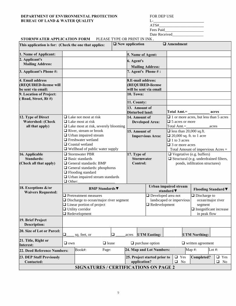
STORMWATER APPLICATION FORM PLEASE TYPE OR PRINT IN INK.
9
This application is for: (Check the one that applies: New application Amendment
1. Name of Applicant: 5. Name of Agent: 2. Applicant's Mailing Address:
6. Agent's Mailing Address:
3. Applicant's Phone #: 7. Agent's Phone # :
4. Email address (REQUIRED-license will be sent via email:
8.E-mail address: (REQUIRED-license will be sent via email
9. Location of Project: ( Road, Street, Rt #)
10. Town:
11. County: 13. Amount of Disturbed land:
Total Amt.= ___________ acres
12. Type of Direct Watershed: (Check all that apply)
Lake not most at risk
Lake most at risk
Lake most at risk, severely blooming
River, stream or brook
Urban impaired stream
Freshwater wetland
Coastal wetland
Wellhead of public water supply
14. Amount of Developed Area:
1 or more acres, but less than 5 acres
5 acres or more
Total Amt.=____________acres 15. Amount of Impervious Area:
less than 20,000 sq.ft.
20,000 sq. ft. to 1 acre
1 to 3 acres
3 or more acres
Total Amount of impervious Acres =
16. Applicable Standards: (Check all that apply)
Stormwater PBR
Basic standards
General standards: BMP
General standards: phosphorus
Flooding standard
Urban impaired stream standards
Other:___________________
17. Type of Stormwater Control:
Vegetative (e.g. buffers)
Structural (e.g. underdrained filters,
ponds, infiltration structures)
18. Exceptions &/or Waivers Requested:
BMP Standards▼ Urban impaired stream
standard▼ Flooding Standard▼ Pretreatment measures
Discharge to ocean/major river segment
Linear portion of project
Utility corridor
Redevelopment
Developed area not
landscaped or impervious
Redevelopment
Discharge to
ocean/major river
segment
Insignificant increase
in peak flow
19. Brief Project Description:
20. Size of Lot or Parcel: ____ sq. feet, or _____acres UTM Easting: UTM Northing:
21. Title, Right or Interest: own lease purchase option written agreement
22. Deed Reference Numbers:
Book#:
Page:
24. Map and Lot Numbers: Map #:
Lot #:
23. DEP Staff Previously Contacted:
25. Project started prior to application?
Yes
No
Completed? Yes
No
SIGNATURES / CERTIFICATIONS ON PAGE 2

STORMWATER APPLICATION FORM
10
26. Resubmission of Application?
Yes
No
If yes, previous application #
Previous project manager:
27. Written Notice of Violation?
Yes
No
If yes, name of DEP enforcement staff involved:
28. Detailed Directions to the Project Site:
29. Stormwater Permit by Rule Submissions▼ 30. Stormwater Application Submissions▼ This form (including signature page)
Fee
Topographic Map
Plan or Drawing
Photos of Area
This form (including signature page)
Fee
Proof of title, right or interest
Certificate of good standing (if applicable)
Photos of Area
Copy of Public Notice
Professional & Notice Certification
Basic standards submissions
General standards submissions
Flooding standard submissions
Other standard submissions
Compensation Fee (if required)
31. FEES, Amount Enclosed:
Does the agent have an interest in the project? If yes, what is the interest?: Yes No
IMPORTANT: IF THE SIGNATURE BELOW IS NOT THE APPLICANT'S SIGNATURE, ATTACH LETTER OF AGENT AUTHORIZATION SIGNED BY THE APPLICANT. By signing below the applicant (or authorized agent), certifies that he or she has read and understood the following:
CERTIFICATIONS / SIGNATURES
"I certify under penalty of law that I have personally examined the information submitted in this document and all attachments thereto and that, based on my inquiry of those individuals immediately responsible for obtaining the information, I believe the information is true, accurate, and complete. I am aware there are significant penalties for submitting false information, including the possibility of fine and imprisonment. I authorize the Department to enter the property that is the subject of this application, at reasonable hours, including buildings, structures or conveyances on the property, to determine the accuracy of any information provided herein.
Further, I hereby authorize the DEP to send me an electronically signed decision on the license I am applying for with this application by e-mailing the decision to the electronic address located on the front page of this application (see #4 for the applicant and #9 for the agent.” Signed:______________________________________ Title______________________________Date:_________________ Notice of Intent to Comply with Maine Construction General Permit
With this Stormwater Law application form and my signature below, I am filing notice of my intent to carry out work which meets the requirements of the Maine Construction General Permit (MCGP). I have read and will comply with all of the MCGP standards. Signed_________________________________________Date:_______________________
NOTE: If a Notice of Intent is required, you must file a Notice of Termination (attached as Form G) within 20 days of
completing permanent stabilization of the project site.

11
ADDITIONAL SIGNATURES / CERTIFICATIONS
The person responsible for preparing this application and/or attaching pertinent site and design information
hereto, by signing below, certifies that the application for stormwater approval is complete and accurate to the
best of his/her knowledge.
Signature: ______________________________ Re/Cert/Lic No.:_____________________________
Engineer __________________________________
Name (print): __________________________ Geologist __________________________________
Soil Scientist _______________________________
Date: __________________________________ Land Surveyor ______________________________
Site Evaluator ______________________________
Active Member of the Maine Bar ________________
Professional Landscape Architect _______________

12
FORM B
PUBLIC NOTICE:
NOTICE OF INTENT TO FILE
Please take notice that
______________________________________________________________________________________
(Name, Address and Phone # of Applicant)
___________________________________________________________________________________
is intending to file a Stormwater Law permit application with the Maine Department of
Environmental Protection pursuant to the provisions of 38 M.R.S.A. § 420-D on or about
______________________________________________
(anticipated filing date)
The application is for
___________________________________________________________________________________
(description of the project)
___________________________________________________________________________________
at the following location: ________________________________________________________________
(project location)
A request for a public hearing or a request that the Board of Environmental Protection assume jurisdiction
over this application must be received by the Department in writing, no later than 20 days after the
application is found by the Department to be complete and is accepted for processing. A public hearing
may or may not be held at the discretion of the Commissioner or Board of Environmental Protection.
Public comment on the application will be accepted throughout the processing of the application.
For Federally licensed, permitted, or funded activities in the Coastal Zone, review of this application shall
also constitute the State's consistency review in accordance with the Maine Coastal Program pursuant to
Section 307 of the federal Coastal Zone Management Act, 16 U.S.C. § 1456. (Delete if not applicable.)
The application will be filed for public inspection at the Department of Environmental Protection's office in
(Portland, Augusta or Bangor)(circle one) during normal working hours. A copy of the application may
also be seen at the municipal offices in _______________________________, Maine.
(town)
Written public comments may be sent to the regional office in Portland, Augusta, or Bangor where the
application is filed for public inspection:
MDEP, Central Maine Regional Office, 17 State House Station, Augusta, Maine 04333
MDEP, Southern Maine Regional Office, 312 Canco Road, Portland, Maine 04103
MDEP, Eastern Maine Regional Office, 106 Hogan Road, Bangor, Maine 04401

13
FORM C
PUBLIC NOTICE FILING AND CERTIFICATION
The DEP Rules, Chapter 2, require an applicant to provide public notice for all Stormwater Law projects with the
exception of minor revisions and condition compliance applications. In the notice, the applicant must describe
the proposed activity and where it is located. “Abutter” for the purposes of the notice provision means any
person who owns property that is BOTH (1) adjoining and (2) within one mile of the delineated project
boundary, including owners of property directly across a public or private right of way.
1. Newspaper: You must publish the Notice of Intent to File in a newspaper circulated in the area where the
activity is located. The notice must appear in the newspaper within 30 days prior to the filing of the
application with the Department. You may use the attached Notice of Intent to File form, or one containing
identical information, for newspaper publication and certified mailing.
2. Abutting Property Owners: You must send a copy of the Notice of Intent to File by certified mail to the
owners of the property abutting the activity. Their names and addresses can be obtained from the town tax
maps or local officials. They must receive notice within 30 days prior to the filing of the application with the
Department.
3. Municipal Office: You must send a copy of the Notice of Intent to File and a duplicate of the entire application to the Municipal Office.
ATTACH a list of the names and addresses of the owners of abutting property.
CERTIFICATION
By signing below, the applicant or authorized agent certifies that:
1. A Notice of Intent to File was published in a newspaper circulated in the area where the project site is located
within 30 days prior to filing the application;
2. A certified mailing of the Notice of Intent to File was sent to all abutters within 30 days of the filing of the
application;
3. A certified mailing of the Notice of Intent to File, and a duplicate copy of the application was sent to the
town office of the municipality in which the project is located; and
4. Provided notice of, if required, and held a public informational meeting in accordance with Chapter 2, Rules
Concerning the Processing of Applications, Section 14, prior to filing the application. Notice of the meeting
was sent by certified mail to abutters and to the town office of the municipality in which the project is located
at least ten days prior to the meeting. Notice of the meeting was also published once in a newspaper
circulated in the area where the project site is located at least seven days prior to the meeting.
The Public Informational Meeting was held on _________________________________.
Date
Approximately _________ members of the public attended the Public Informational Meeting.
_____________________________________ _______________________
Signature of Applicant or authorized agent Date

FORM D 5/2014
FEE WORKSHEET
Use this form to help determine the permit fee. The fee is based upon the amount of disturbed area
associated with the project. THE EXAMPLE BELOW IS NOT BASED ON CURRENT FEES. To
determine current stormwater licensing fees, please visit the Department’s website at:
http://www.maine.gov/dep/permits/
NOTE: Ditches, swales, ditch turn-outs, level spreaders, and similar Best Management Practices (BMPs) used
solely to convey or discharge water to a vegetated buffer are not considered, by themselves, to constitute
structural BMPs, provided that the applicant assumes that all water quality treatment takes place in the buffer.
If any treatment is assumed within the BMPs used to convey water to the buffer, they are treated as structural
BMPs for the purposes of determining the applicable fee (and review period). "Disturbed area" and "impervious
area" are defined in Chapter 500, Section 2(C) and (E).
Example (a): If solely vegetative control measures are used (e.g. buffers), the example fees are
$250.00* for up to one acre of disturbed area, plus $125.00† for each additional whole acre of
disturbed area.
Project will create 2.34 acres of disturbed area.
Fee = $250.00 + [$125.00 x (1)] = $375.00
Your fee:
Current fee from fee schedule plus [1/2 current fee times # additional whole acres] equals application fee
$________ + [ $_______ X (___)] = $________
Example (b): If any structural control measures are used (e.g. underdrained filters, ponds, infiltration
systems), the example fees are $500.00 for up to one acre of disturbed area, plus $250.00 for each
additional whole acre of disturbed area.
Project will create 2.34 acres of disturbed area.
Fee = $500.00 + [$250.00 x (1)]. Fee = $750.00.
Your fee:
Current fee from fee schedule plus [1/2 current fee times # additional whole acres] equals application fee
$________ + [ $_______ X (___)] = $________
* The total fee for the first acre of disturbed area is obtained by combining the processing and licensing fees contained
in the current fee schedule.
† The fee for each additional whole acre of disturbed area is one-half the combined processing and licensing fee.
14

15
FORM E SUBMITTAL CHECKLIST
Submissions for all stormwater projects, as applicable, except stormwater PBR:
Completed application form with signatures
Fee worksheet & fee
Professional & notice certification
Notice of intent to file
Proof of title, right, or interest
Certificate of Good Standing (corporations only)
Photos of the project site
Basic standards submissions:
Erosion and sedimentation control plan
Location plan
Site details
Inspection and maintenance plan
List of measures
Inspection & maintenance tasks
Task frequency
Responsible parties
Maintenance plans
Housekeeping plan
General standards submissions:
Narrative
Drainage plans
Calculations
Water volume
Buffer sizing
Details, designs, and specifications
Ponds
Underdrained vegetated filters
Infiltration systems
Buffers
Phosphorus export calculations
Maintenance contract
Flooding standard submissions:
Control of peak flows
Details, designs, and specifications
16
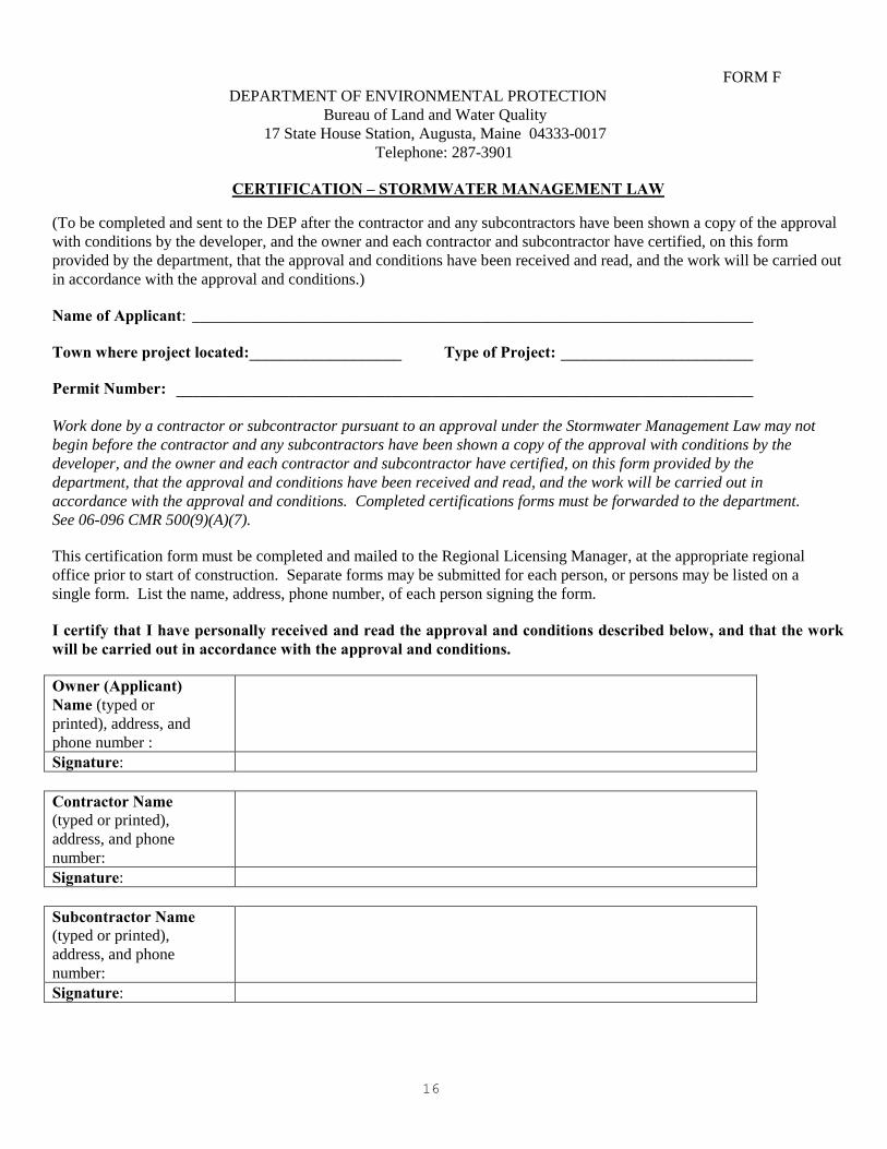
FORM F
DEPARTMENT OF ENVIRONMENTAL PROTECTION
Bureau of Land and Water Quality
17 State House Station, Augusta, Maine 04333-0017
Telephone: 287-3901
CERTIFICATION – STORMWATER MANAGEMENT LAW
(To be completed and sent to the DEP after the contractor and any subcontractors have been shown a copy of the approval
with conditions by the developer, and the owner and each contractor and subcontractor have certified, on this form
provided by the department, that the approval and conditions have been received and read, and the work will be carried out
in accordance with the approval and conditions.) Name of Applicant: ______________________________________________________________________
Town where project located:___________________ Type of Project: ________________________ Permit Number: ________________________________________________________________________ Work done by a contractor or subcontractor pursuant to an approval under the Stormwater Management Law may not
begin before the contractor and any subcontractors have been shown a copy of the approval with conditions by the
developer, and the owner and each contractor and subcontractor have certified, on this form provided by the
department, that the approval and conditions have been received and read, and the work will be carried out in
accordance with the approval and conditions. Completed certifications forms must be forwarded to the department.
See 06-096 CMR 500(9)(A)(7).
This certification form must be completed and mailed to the Regional Licensing Manager, at the appropriate regional
office prior to start of construction. Separate forms may be submitted for each person, or persons may be listed on a
single form. List the name, address, phone number, of each person signing the form.
I certify that I have personally received and read the approval and conditions described below, and that the work will be carried out in accordance with the approval and conditions.
Owner (Applicant) Name (typed or
printed), address, and
phone number :
Signature:
Contractor Name
(typed or printed),
address, and phone
number:
Signature:
Subcontractor Name
(typed or printed),
address, and phone
number:
Signature:

17
FORM G
NOTICE OF TERMINATION for use with CONSTRUCTION GENERAL PERMIT
PLEASE TYPE OR PRINT IN BLACK INK ONLY Name of Applicant (Owner):
Applicant Mailing Address:
Town/City: State: Zip Code:
Daytime phone: (with area code)
E Mail, if available:
Name of Agent: Agent Phone #:
Permit number (if known):
Project Location: (Town/City):
UTM Northing: (if known)
UTM Easting: (if known
Map #: Lot #: County:
Name of waterbody(ies) to which the disturbed area drains, or name of municipality if area drains to an MS4:
Name/description of project
I am filing notice of my Notice of Termination indicating that permanent stabilization has been completed or, if the project was a
common plan of development or sale, that the requirements of the Construction General Permit at Part IV(B)(2) have been completed.
I have attached all the required submittals. Notification forms cannot be accepted without the necessary attachments.
ALL: Photographs showing the completed project and affected area, except as provided in Part IV(B)(3)(c) of the MCGP.
IF this form is not being signed by the landowner or lessee of the property, attach documentation showing authorization to
sign; OR
Check here to reference documentation showing authorization to sign that was submitted with the Notice of Intent if the
documentation showing authorization to sign applies and is still current.
I authorize staff of the Departments of Environmental Protection to access the project site for the purpose of determining compliance
with the general permit.
Signature of Applicant:
Date:
Retain your records. The permittee is required to retain copies of any forms, submissions, reports, or other materials required by this
general permit for a period of at least three years from the completion of permanent stabilization.
OFFICE USE ONLY
Staff Staff
NOI # FP Date Acc.
Date
Def.
Date
After
Photos

18
FORM H
SOIL AND WATER CONSERVATION DISTRICT OPTIONAL REVIEW
Date: ________________________________________________________________
Applicant's name: ________________________________________________________________
Address: ________________________________________________________________
Project name: ________________________________________________________________
Project location: ________________________________________________________________
As part of my DEP application, pursuant to the Site Location of Development Law (Site Law) 38 M.R.S.A.
§ § 481-490, I request that the Conservation District indicated below review (a) Erosion and
Sedimentation Control submissions and (b) Stormwater Management submissions. I will enter into an
agreement with the District for their review services.
Check one:
____ Androscoggin Valley SWCD
____ Cumberland County SWCD
____ Oxford County SWCD
____ York County SWCD
_________________________________________
Signature of Applicant

19
Section 3. Submissions
The applicant shall use the application form provided by the department and include evidence
that affirmatively demonstrates that the standards will be met, including information such as
described in this section.
A. Design requirements. A design for a stormwater management system that includes any form
of conveyance structure must be prepared under the supervision of, and dated, signed and
sealed by, a professional engineer registered in the State of Maine, who by education,
training, or experience is knowledgeable in stormwater management.
B. Basic standards submissions. Each project is required to meet the basic standards (Chapter
500, Section 4(A) of the Stormwater Management Rules. These submissions are required for
all sites except those that qualify for stormwater PBR. An erosion and sedimentation control
plan or an inspection and maintenance plan for a project that does not qualify for a stormwater
PBR must be prepared by a professional engineer registered in the State of Maine, or a
certified erosion and sedimentation control professional.
(1) Erosion and sedimentation control plan. Submit a plan showing designs for temporary and
permanent stabilization measures for all disturbed areas within the project site and for all
proposed stormwater management structures. See Appendix A of Chapter 500 for
guidance on preparing an erosion and sedimentation control plan. At a minimum, the
erosion and sedimentation control plan must include the following.
(a) Location plan. Submit a plan sheet or set of plans showing, at a minimum, the
location of structures, disturbed land, pre-construction site topography, post-
construction site topography, on-site or adjacent water resources, and all erosion and
sediment control measures.
(b) Site details. Submit a plan sheet showing the following.
(i) Erosion and sedimentation control notes. Erosion and sedimentation control notes,
must include, but not limited to, permanent stabilization measures, seeding and
mulching rates, and a construction schedule with the proposed construction dates
and timeframe for major earth moving and construction events.
(ii) Construction and installation details. Construction and installation details for
erosion and sedimentation control measure must include, but are not limited to,
sedimentation barriers, ditch lining, rip rap, and culvert inlet and outlet designs.
NOTE: For guidance, see the Maine Erosion and Sediment Control BMP Manual.
(2) Inspection and maintenance plan. Submit a plan for the inspection and maintenance of the
temporary and permanent erosion and sedimentation controls for the project site as

20
described in Appendices A and B of Chapter 500. At a minimum, the inspection and
maintenance plan must include the following:
(a) List of measures. Submit a list of the erosion control measure and stormwater
management measures to be inspected and maintained (e.g., “parking lot catch
basins”).
(b) Inspection and maintenance tasks. Submit a list of inspection and maintenance tasks
specific to each erosion control measure or stormwater management measure (e.g.,
“remove accumulated sediment s in basin sumps”). Submit the specific qualifications
of the person performing each task (e.g., “a professional engineer registered in the
State of Maine will inspect the retention pond embankment”).
(c) Task frequency. Indicate the required frequency of each inspection and maintenance
task (e.g., “accumulated sediments will be removed from all catch basins annually in
early spring”).
(d) Responsible parties. Submit the name, job title, employer, employer address, phone
number, and current email contact information for the person responsible for ensuring
that inspection and maintenance tasks are completed. Submit the names, job titles,
employer addresses, phone number, and any current email contact information of the
engineers or other design professionals who designed the erosion control measures
and stormwater management measures for the site. Include suppliers of proprietary
erosion control measures or proprietary stormwater management measures used on
the site.
(e) Maintenance plan for detention basins or retention ponds. For each stormwater
management pond or basin submit, at a minimum, an inspection and maintenance
plan for the pond’s embankments, outlet structure, and emergency spillway. Include
as part of this plan provisions for the removal and disposal of accumulated sediments
in the pond and the control of woody vegetation on the pond’s embankments.
(f) Maintenance plan for infiltration structures. For each infiltration structure, submit, at
a minimum, an inspection and maintenance plan for the structure’s pretreatment
measures, embankments, surface lining, and overflow spillway. Include as part of this
plan provisions for the removal and disposal of accumulated sediments in the
structure and for the rehabilitation of clogged surface linings.
(g) Maintenance plan for vegetated underdrained filters. For each vegetated underdrained
filter, submit, at a minimum, an inspection and maintenance plan for the filter
embankments, surface lining, underdrain piping, and overflow spillway. Include as
part of this plan provisions for the removal and disposal of accumulated sediments in
the structure, the rehabilitation of clogged surface linings, and the flushing of
underdrain piping.

21
(h) Maintenance plan for stormwater buffers. At a minimum, submit a plan for
inspecting and maintaining the integrity and function of the project’s stormwater
buffers. As part of this plan, include provisions for the inspection, maintenance, and,
if necessary, reconstruction of any level spreaders or ditch turnouts used to spread
runoff into the buffers. Include as part of this plan provisions for the frequent
removal and disposal of accumulated sediments and debris in the level spreader and
turnout bays, provisions for the inspection and repair of any eroded areas within the
buffer, and provisions for the reestablishment of buffer vegetation destroyed by post-
construction activities.
(i) Maintenance plan for manufactured stormwater treatment systems. For each
manufactured system installed on the site, submit an inspection and maintenance plan
for the system’s inlet, treatment chamber(s), and outlet. The plan shall conform to
the inspection and maintenance guidelines recommended by the manufacturer based
on the estimated runoff and pollutant load expected to the system from the project.
As part of this plan, include provisions for the frequent removal of accumulated
sediments, debris, and contaminated waters from the system and, if applicable,
provisions for the removal, disposal, and replacement of any clogged or spent filter
media.
(j) Maintenance plan for ditches, culverts, and storm drains. Provide an inspection and
maintenance plan for all stormwater conveyances to be built or installed on the site –
including, but not limited to, ditches, swales, culverts, catch basins, and storm drain
piping. As part of this plan, include provisions for the repair of eroded areas at the
inlet, within, and at the outlet of each conveyance and include provisions for the
frequent removal and disposal of accumulated sediments and debris at the inlet,
within, and at the outlet of each conveyance.
(3) Housekeeping. Submit a plan to address spill prevention, groundwater protection, fugitive
sediment and dust, debris and other materials, trench or foundation de-watering, or non-
stormwater charges, as applicable to the specific site. Housekeeping requirements are
described in Appendix C of Chapter 500.
C. General standards submissions. In addition to the basic standards submissions, a project
required to meet general standards must provide the following information and design
specifications.
(1) Narrative. A narrative describing site layout, and on-site and off-site watershed
hydrology, including all new and existing buildings and facilities, which may be affected
by the site runoff. Provide the total amount of impervious area, disturbed area, and
developed area created by the project.
(2) Drainage Plans. All topographic features, such as buildings and other facilities,
drainageways, cover type, roads, drainage easements and subcatchment boundaries for
pre-construction and post-construction conditions must be shown on a plan. Show all

22
hydrologic flow lines and hydrologic soil groups boundaries on a plan and identify each
subcatchment, reach, and pond consistent with the runoff model. For post-construction
conditions, show all new stormwater management structures and changes to the
hydrologic drainage patterns.
(3) Calculations. The stormwater runoff calculations for measures designed to meet general
standards must be in accordance with acceptable engineering practice, including the
following.
(a) Water volume. Calculations used to determine the water volume needed to be filtered,
infiltrated, or detained based on the proposed site development must be provided.
(b) Buffer sizing. Buffers used for runoff control must be sized according to requirements
described in Appendix F.
(4) Details, designs, and specifications. Submit designs, construction details, and technical
specifications for each stormwater management measure that will be constructed,
installed, or managed on the site.
(a) Ponds. Submit a plan sheet having the following details and specifications for each
stormwater management pond: a topographic plan view of the pond, a cross section of
the pond embankment, a cross section and profile of the overflow spillway, test pit
information, and specifications for constructing and stabilizing the pond’s
embankment. The peak storage depth required to meet the general standards must be
shown on a cross section for each pond embankment. Submit a cross section of the
gravel underdrain filter for any pond used to meet the standards. This cross section
must specify the width and elevation of the pond bench, the thickness and gradation
for the gravel drainage fill, and the diameter and material for the perforated
underdrain pipe.
(b) Underdrained vegetated filters. Submit a plan sheet having the following details and
specifications for each underdrained vegetated filter area: a plan view of the filter
area, a cross section of the embankment for the filter area at the overflow spillway, a
cross section and profile of the overflow spillway, a cross section of the underdrain
filter, and specifications for stabilizing the filter bed with sod. The cross section of
the underdrain filter must specify the thickness and composition of the soil filter
media, the thickness and gradation of the gravel drainage fill, and the diameter and
material type for the perforated underdrain pipe.
(c) Infiltration. Submit a plan sheet showing the following details and specifications for
each infiltration measure: a plan view of the infiltration structure, a cross section of
the infiltration measure’s runoff storage area, a cross section and profile of the
structure’s overflow spillway, and details and specifications for permanently
stabilizing the infiltration area. The following information must be included, if
required, as determined by the department and described below.

23
(i) Locations of any monitoring wells necessary for assessing the infiltration
measure’s performance or stormwater infiltration impacts on groundwater, surface
irrigation sites, or subsurface wastewater disposal systems must be shown on the
site plan.
(ii) Location of an existing or proposed surface irrigation site, waste disposal site,
subsurface wastewater disposal system, or other facility that could be impacted by
operation of the infiltration system must be shown on the site plan.
(iii)Location of any soil borings, test pits, or other explorations used to determine
depth to groundwater, separation from bedrock, or other design information must
be shown on the site plan.
(iv) Location of any water supply wells on-site or within 300 feet of the infiltration
areas, zones of contribution for public water supply wells must be shown on the
plan sheet.
(v) Location of storage for any petroleum products, pesticides, fertilizers, road salt,
hazardous materials, or other materials with the potential to contaminate
groundwater must be shown on the site plan.
(vi) Plans for management of any potential contaminants and soil sample analyses,
such as a spill prevention, control, and countermeasure plan, must be submitted
with appropriate supporting information.
(vii) Depth to the seasonal high groundwater table, depth to bedrock, and the
thickness and composition of any liner used for restricting infiltration rates must
be shown on the cross section view of the infiltration structure.
(d) Buffers. Submit a topographic site plan showing the location of each buffer on the
site, showing the layout of any berm level spreaders used to spread flows into each
buffer, identifying the soil type and cover type within each buffer, and showing the
land use and impervious and developed area draining to each buffer area. Provide a
typical cross section for the berm level spreaders showing the geometry of the berm,
the geometry of the upstream storage area, and the specifications for the berm
material. Submit information demonstrating that the inslope fill material will have
slopes no steeper than 3:1. Submit documentation, in the form of draft covenants and
restrictions, demonstrating that buffer area(s) will be maintained as buffer.
(5) Phosphorus export calculations. An application for a project using the phosphorus
standards must include phosphorus export calculations.
NOTE: For guidance in determining phosphorus export see "Phosphorus Control in Lake
Watersheds", Maine Department of Environmental Protection.

24
(6) Maintenance contract. Submit an executable contract with a third-party for the removal
of accumulated sediments, oils, and debris within any proprietary devices and the
replacement of any absorptive filters if these measures are part of a project’s proposed
stormwater management system. An applicant that has the personnel and equipment
necessary to perform maintenance on any proprietary devices may submit a demonstration
of capability in lieu of an executable contract with a third party. The frequency of
sediment clean-out and filter replacements must be consistent with the unit’s storage
capacity and the estimated pollutant load from the contributing drainage area. This clean-
out frequency is usually established by the manufacturer of the proprietary system when
sizing the device for the project. The contract must state that a qualified professional will
perform maintenance on stormwater management systems to maintain pollutant removal
levels.
D. Flooding standard submissions. In addition to the basic standards submissions and general
standards submissions, a project required to meet the flooding standard must provide the
following information and design specifications.
(1) Control of peak flows. If a project must meet the flooding standard, the project must be
designed to control the peak flows from the 2-, 10- and 25-year, 24-hour storms. This is
in addition to the submittal requirements listed in Section 8(C) and (D) above.
(2) Details, designs, and specifications. Provide runoff curve number computations and time
of concentration calculations for each subcatchment. Areas may qualify as subcatchments
based on the characteristics of the site or the model used. The department will review all
methods of determining subcatchments on a case-by-case basis. Provide a reach
description and reach routing analysis for each drainage structure and provide pond
descriptions and storage routing calculation for any stormwater management structure,
detention pond and culvert backwater areas.
Acceptable stormwater methodologies and models include, but are not limited to, “TR-
20 - Computer Program for Project Formulation - Hydrology,” Second Edition, U.S.
Department of Agriculture, Soil Conservation Service (March 1986); and “TR-55 -
Urban Hydrology for Small Watersheds,” Second Edition, U.S. Department of
Agriculture, Soil Conservation Service (June 1986); “WIN TR-55 2003.00.24
Microcomputer Program,” (January 12, 2003); and “HEC-HMS Flood Hydrology
Package,” U.S. Army Corps of Engineers (January 2001). Any methodology or model
other than those listed must have prior approval from the department.
E. Submissions for other applicable standards. See Chapter 500, Section 4(C), for submittal
requirements for projects subject to the urban impaired stream standard. See Sections 4(E),
5, and 6 for guidance on submittals may be required if the project must meet other applicable
standards of the Stormwater Law.

25
Maine Department of Environmental Protection
STORMWATER PRE-APPLICATION FORM (for all Stormwater Management Law projects requiring full permits under Chapter 500 and for
the stormwater component of Site Location of Development projects. Pre-application meetings
will not be scheduled until the Department has received this form and required attachments. If
you have questions about the required attachments, please discuss them with the Licensing
Coordinator in Augusta or Portland)
Name of project: _____________________________________________________________
Name of applicant: ___________________________________________________________
Project Location (town): ______________________________ Size of parcel: ____________
Watershed: ________________________ Phosphorus plan required: Yes _____ No ______
Square feet/acres of proposed new impervious area and developed area: __________________
Square feet/acres of proposed new developed area: ___________________________________
Prior/Current permit? Yes ______ No _________If yes, DEP permit #: __________________
Redevelopment? Yes ______ No ______
Existing square feet/acres of impervious area created prior to 11-16-05: __________________
Existing square feet/acres of impervious area created after 11-16-05: ____________________
Describe existing development and when it was constructed:
_____________________________________________________________________________
_____________________________________________________________________________
_____________________________________________________________________________
Description of proposed project: ___________________________________________________
______________________________________________________________________________
______________________________________________________________________________

26
Maine Department of Environmental Protection
If infiltration of stormwater is being considered, please check here _____ and include as much
information as possible related to depth to seasonal high graoundwater and bedrock.
Impact to Protected Natural Resources or Significant Wildlife Habitat? ______ If yes, please
explain:: ____________________________________________________________________
____________________________________________________________________________
____________________________________________________________________________
_____________________________________________________________________________
Submit the following information with the pre-application form for all projects:
Site layout and topography with two –foot contour lines
Subwatershed maps
Streams, wetlands, and other waterbodies with identified setbacks
Land cover types
Proposed BMP’s and approximate locations
On-site soil types
Please submit two copies of this form and all attachments.

27
Section 4. Draft Deed Restriction Language for Buffers
A. Forested buffer, limited disturbance
DECLARATION OF RESTRICTIONS (Forested Buffer, Limited Disturbance)
THIS DECLARATION OF RESTRICTIONS is made this _______________day of ___________,
20___, by _________________________ , ________________________________________________,
(name) (street address)
____________________, ________________County, Maine, ________, (herein referred to as the
(city or town) (county) (zip code)
"Declarant"), pursuant to a permit received from the Maine Department of Environmental Protection
under the Stormwater Management Law, to preserve a buffer area on a parcel of land near
__________________________,____________________________________________________ .
(road name) (known feature and/or town)
WHEREAS, the Declarant holds title to certain real property situated in ___________________, Maine
(town)
described in a deed from__________________________ to ____________________________dated
(name) (name of Declarant)
_______________, 20____, and recorded in Book ____ Page ____ at the _______________County
Registry of Deeds, herein referred to as the "property"; and
WHEREAS, Declarant desires to place certain restrictions, under the terms and conditions herein, over a
portion of said real property (hereinafter referred to as the "Restricted Buffer") described as follows:
(Note: Insert description of restricted buffer area location here)
WHEREAS, pursuant to the Stormwater Management Law, 38 M.R.S.A. Section 420-D and
Chapter 500 of rules promulgated by the Maine Board of Environmental Protection ("Stormwater
Management Rules"), Declarant has agreed to impose certain restrictions on the Restricted Buffer
Area as more particularly set forth herein and has agreed that these restrictions may be enforced
by the Maine Department of Environmental Protection or any successor (hereinafter the
"MDEP"),
NOW, THEREFORE, the Declarant hereby declares that the Restricted Buffer Area is and shall
forever be held, transferred, sold, conveyed, occupied and maintained subject to the conditions
and restrictions set forth herein. The Restrictions shall run with the Restricted Buffer Area and
shall be binding on all parties having any right, title or interest in and to the Restricted Buffer
Area, or any portion thereof, and their heirs, personal representatives, successors, and assigns.
Any present or future owner or occupant of the Restricted Buffer Area or any portion thereof, by
the acceptance of a deed of conveyance of all or part of the Covenant Area or an instrument
conveying any interest therein, whether or not the deed or instrument shall so express, shall be
deemed to have accepted the Restricted Buffer Area subject to the Restrictions and shall agree to
be bound by, to comply with and to be subject to each and every one of the Restrictions
hereinafter set forth.

28
1. Restrictions on Restricted Buffer Area. Unless the owner of the Restricted Buffer Area, or
any successors or assigns, obtains the prior written approval of the MDEP, the Restricted Buffer
Area must remain undeveloped in perpetuity. To maintain the ability of the Restricted Buffer
Area to filter and absorb stormwater, and to maintain compliance with the Stormwater
Management Law and the permit issued thereunder to the Declarant, the use of the Restricted
Buffer Area is hereinafter limited as follows.
a. No soil, loam, peat, sand, gravel, concrete, rock or other mineral substance, refuse, trash,
vehicle bodies or parts, rubbish, debris, junk waste, pollutants or other fill material may
be placed, stored or dumped on the Restricted Buffer Area, nor may the topography of the
area be altered or manipulated in any way;
b. Any removal of trees or other vegetation within the Restricted Buffer Area must be
limited to the following:
(i) No purposefully cleared openings may be created and an evenly distributed stand of
trees and other vegetation must be maintained. An "evenly distributed stand of trees "
is defined as maintaining a minimum rating score of 24 points in any 25 foot by 50
foot square (2500 square feet) area, as determined by the following rating scheme:
Diameter of tree at 4½ feet
above ground level
Points
2 - 4 inches 1
4 - 8 inches 2
8 - 12 inches 4
>12 inches 8
Where existing trees and other vegetation result in a rating score less than 24 points,
no trees may be cut or sprayed with biocides except for the normal maintenance of
dead, windblown or damaged trees and for pruning of tree branches below a height of
12 feet provided two thirds of the tree's canopy is maintained;
(ii) No undergrowth, ground cover vegetation, leaf litter, organic duff layer or mineral
soil may be disturbed except that one winding path, that is no wider than six feet and
that does not provide a downhill channel for runoff, is allowed through the area;
c. No building or other temporary or permanent structure may be constructed, placed or
permitted to remain on the Restricted Buffer Area, except for a sign, utility pole or fence;
d. No trucks, cars, dirt bikes, ATVs, bulldozers, backhoes, or other motorized vehicles or
mechanical equipment may be permitted on the Restricted Buffer Area;

29
e. Any level lip spreader directing flow to the Restricted Buffer Area must be regularly
inspected and adequately maintained to preserve the function of the level spreader.
Any activity on or use of the Restricted Buffer Area inconsistent with the purpose of these
Restrictions is prohibited. Any future alterations or changes in use of the Restricted Buffer
Area must receive prior approval in writing from the MDEP. The MDEP may approve such
alterations and changes in use if such alterations and uses do not impede the stormwater
control and treatment capability of the Restricted Buffer Area or if adequate and appropriate
alternative means of stormwater control and treatment are provided.
2. Enforcement. The MDEP may enforce any of the Restrictions set forth in Section 1 above.
3. Binding Effect. The restrictions set forth herein shall be binding on any present or future
owner of the Restricted Buffer Area. If the Restricted Buffer Area is at any time owned by
more than one owner, each owner shall be bound by the foregoing restrictions to the extent
that any of the Restricted Buffer Area is included within such owner's property.
4. Amendment. Any provision contained in this Declaration may be amended or revoked only
by the recording of a written instrument or instruments specifying the amendment or the
revocation signed by the owner or owners of the Restricted Buffer Area and by the MDEP.
5. Effective Provisions of Declaration. Each provision of this Declaration, and any agreement,
promise, covenant and undertaking to comply with each provision of this Declaration, shall
be deemed a land use restriction running with the land as a burden and upon the title to the
Restricted Buffer Area.
6. Severability. Invalidity or unenforceability of any provision of this Declaration in whole or
in part shall not affect the validity or enforceability of any other provision or any valid and
enforceable part of a provision of this Declaration.
7. Governing Law. This Declaration shall be governed by and interpreted in accordance with
the laws of the State of Maine.
___________________________
(NAME)
STATE OF MAINE __________________ County, ____________________, 20__. County) (date)
Personally appeared before me the above named ____________________________, who swore
to the truth of the foregoing to the best of (his/her) knowledge, information and belief and
acknowledged the foregoing instrument to be (his/her) free act and deed.
________________________________
Notary Public
_________________________________

30
B. Forested buffer, no disturbance DECLARATION OF RESTRICTIONS (Forested Buffer, No Disturbance)
THIS DECLARATION OF RESTRICTIONS is made this __________day of ______________ , 20___,
by _________________________, __________________________________________________ ,
(name) (street address)
____________________, _________________County, Maine, ________ , (herein referred to as the
(city or town) (county) (zip code)
"Declarant", pursuant to a permit received from the Maine Department of Environmental Protection
under the Stormwater Management Law, to preserve a buffer area on a parcel of land near
_______________________, ________________________________________________ .
(road name) (known feature and/or town)
WHEREAS, the Declarant holds title to certain real property situated in ________________, Maine
(town)
described in a deed from _________________________to _____________________________, dated
(name) (name of Declarant)
_______________, 20____, and recorded in Book ____ Page ____ at the _______________County
Registry of Deeds, herein referred to as the "property"; and
WHEREAS, Declarant desires to place certain restrictions, under the terms and conditions herein, over a
portion of said real property (hereinafter referred to as the "Restricted Buffer") described as follows:
(Note: Insert description of restricted buffer location here)
WHEREAS, pursuant to the Stormwater Management Law, 38 M.R.S.A. Section 420-D and
Chapter 500 of rules promulgated by the Maine Board of Environmental Protection ("Stormwater
Management Rules"), Declarant has agreed to impose certain restrictions on the Restricted Buffer
Area as more particularly set forth herein and has agreed that these restrictions may be enforced
by the Maine Department of Environmental Protection or any successor (hereinafter the
"MDEP"),
NOW, THEREFORE, the Declarant hereby declares that the Restricted Buffer Area is and shall
forever be held, transferred, sold, conveyed, occupied and maintained subject to the conditions
and restrictions set forth herein. The Restrictions shall run with the Restricted Buffer Area and
shall be binding on all parties having any right, title or interest in and to the Restricted Buffer
Area, or any portion thereof, and their heirs, personal representatives, successors, and assigns.
Any present or future owner or occupant of the Restricted Buffer Area or any portion thereof, by
the acceptance of a deed of conveyance of all or part of the Covenant Area or an instrument
conveying any interest therein, whether or not the deed or instrument shall so express, shall be
deemed to have accepted the Restricted Buffer Area subject to the Restrictions and shall agree to
be bound by, to comply with and to be subject to each and every one of the Restrictions
hereinafter set forth.

31
1. Restrictions on Restricted Buffer Area. Unless the owner of the Restricted Buffer Area, or
any successors or assigns, obtains the prior written approval of the MDEP, the Restricted Buffer
Area must remain undeveloped in perpetuity. To maintain the ability of the Restricted Buffer
Area to filter and absorb stormwater, and to maintain compliance with the Stormwater
Management Law and the permit issued thereunder to the Declarant, the use of the Restricted
Buffer Area is hereinafter limited as follows.
a. No soil, loam, peat, sand, gravel, concrete, rock or other mineral substance, refuse, trash,
vehicle bodies or parts, rubbish, debris, junk waste, pollutants or other fill material will be
placed, stored or dumped on the Restricted Buffer Area, nor shall the topography of the area be
altered or manipulated in any way;
b. No trees may be cut or sprayed with biocides except for the normal maintenance of dead,
windblown or damaged trees and for pruning of tree branches below a height of 12 feet provided
two thirds of the tree's canopy is maintained;
c. No undergrowth, ground cover vegetation, leaf litter, organic duff layer or mineral soil
may be disturbed except that one winding path, that is no wider than six feet and that does not
provide a downhill channel for runoff, is allowed through the area;
d. No building or other temporary or permanent structure may be constructed, placed or
permitted to remain on the Restricted Buffer Area, except for a sign, utility pole or fence;
e. No trucks, cars, dirt bikes, ATVs, bulldozers, backhoes, or other motorized vehicles or
mechanical equipment may be permitted on the Restricted Buffer Area;
f. Any level lip spreader directing flow to the Restricted Buffer Area must be regularly
inspected and adequately maintained to preserve the function of the level spreader.
Any activity on or use of the Restricted Buffer Area inconsistent with the purpose of these
Restrictions is prohibited. Any future alterations or changes in use of the Restricted Buffer Area
must receive prior approval in writing from the MDEP. The MDEP may approve such
alterations and changes in use if such alterations and uses do not impede the stormwater control
and treatment capability of the Restricted Buffer Area or if adequate and appropriate alternative
means of stormwater control and treatment are provided.
2. Enforcement. The MDEP may enforce any of the Restrictions set forth in Section 1 above.
3. Binding Effect. The restrictions set forth herein shall be binding on any present or future
owner of the Restricted Buffer Area. If the Restricted Buffer Area is at any time owned by more
than one owner, each owner shall be bound by the foregoing restrictions to the extent that any of
the Restricted Buffer Area is included within such owner's property.
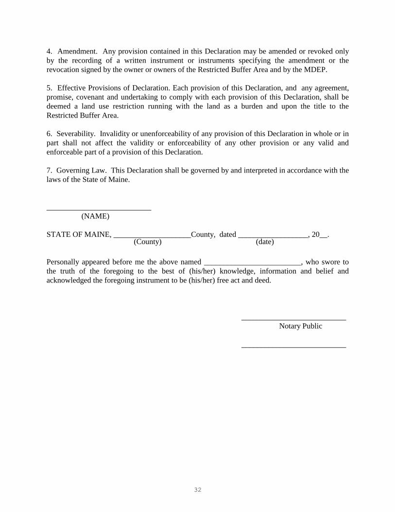
32
4. Amendment. Any provision contained in this Declaration may be amended or revoked only
by the recording of a written instrument or instruments specifying the amendment or the
revocation signed by the owner or owners of the Restricted Buffer Area and by the MDEP.
5. Effective Provisions of Declaration. Each provision of this Declaration, and any agreement,
promise, covenant and undertaking to comply with each provision of this Declaration, shall be
deemed a land use restriction running with the land as a burden and upon the title to the
Restricted Buffer Area.
6. Severability. Invalidity or unenforceability of any provision of this Declaration in whole or in
part shall not affect the validity or enforceability of any other provision or any valid and
enforceable part of a provision of this Declaration.
7. Governing Law. This Declaration shall be governed by and interpreted in accordance with the
laws of the State of Maine.
___________________________
(NAME)
STATE OF MAINE, ____________________County, dated __________________, 20__.
(County) (date)
Personally appeared before me the above named _________________________, who swore to
the truth of the foregoing to the best of (his/her) knowledge, information and belief and
acknowledged the foregoing instrument to be (his/her) free act and deed.
___________________________
Notary Public
___________________________

33
C. Meadow buffer
DECLARATION OF RESTRICTIONS (Non-Wooded Meadow Buffer)
THIS DECLARATION OF RESTRICTIONS is made this ________day of ____________, 20___, by
_____________________________________, _________________________________________
(name) (street address)
___________________, ________________County, Maine,________, (herein referred to as the
(city or town) (county) (zip code)
"Declarant"), pursuant to a permit received from the Maine Department of Environmental Protection
under the Stormwater Management Law, to preserve a buffer area on a parcel of land near
__________________________, ____________________________________________________ .
(road name) (known feature and/or town)
WHEREAS, the Declarant holds title to certain real property situated in _________________, Maine
(town)
described in a deed from_________________________to ___________________________, dated
(name) (name of Declarant)
_______________, 20____, and recorded in Book ____ Page ____ at the _______________County
Registry of Deeds, herein referred to as the "property"; and
WHEREAS, Declarant desires to place certain restrictions, under the terms and conditions herein, over a
portion of said real property (hereinafter referred to as the "Restricted Buffer") described as follows:
(Note: Insert description of restricted buffer location here)
WHEREAS, pursuant to the Stormwater Management Law, 38 M.R.S.A. Section 420-D and
Chapter 500 of rules promulgated by the Maine Board of Environmental Protection ("Stormwater
Management Rules"), Declarant has agreed to impose certain restrictions on the Restricted Buffer
Area as more particularly set forth herein and has agreed that these restrictions may be enforced
by the Maine Department of Environmental Protection or any successor (hereinafter the
"MDEP"),
NOW, THEREFORE, the Declarant hereby declares that the Restricted Buffer Area is and shall
forever be held, transferred, sold, conveyed, occupied and maintained subject to the conditions
and restrictions set forth herein. The Restrictions shall run with the Restricted Buffer Area and
shall be binding on all parties having any right, title or interest in and to the Restricted Buffer
Area, or any portion thereof, and their heirs, personal representatives, successors, and assigns.
Any present or future owner or occupant of the Restricted Buffer Area or any portion thereof, by
the acceptance of a deed of conveyance of all or part of the Covenant Area or an instrument
conveying any interest therein, whether or not the deed or instrument shall so express, shall be
deemed to have accepted the Restricted Buffer Area subject to the Restrictions and shall agree to
be bound by, to comply with and to be subject to each and every one of the Restrictions
hereinafter set forth.

34
1. Restrictions on Restricted Buffer Area. Unless the owner of the Restricted Buffer Area, or
any successors or assigns, obtains the prior written approval of the MDEP, the Restricted Buffer
Area must remain undeveloped in perpetuity. To maintain the ability of the Restricted Buffer
Area to filter and absorb stormwater, and to maintain compliance with the Stormwater
Management Law and the permit issued thereunder to the Declarant, the use of the Restricted
Buffer Area is hereinafter limited as follows.
a. No soil, loam, peat, sand, gravel, concrete, rock or other mineral substance, refuse, trash,
vehicle bodies or parts, rubbish, debris, junk waste, pollutants or other fill material will
be placed, stored or dumped on the Restricted Buffer Area, nor may the topography or the
natural mineral soil of the area be altered or manipulated in any way;
b. A dense cover of grassy vegetation must be maintained over the Restricted Buffer Area,
except that shrubs, trees and other woody vegetation may also be planted or allowed to
grow in the area. The Restricted Buffer Area may not be maintained as a lawn or used as
a pasture. If vegetation in the Restricted Buffer Area is mowed, it may be mown no more
than two times per year.
c. No building or other temporary or permanent structure may be constructed, placed or
permitted to remain on the Restricted Buffer Area, except for a sign, utility pole or fence;
d. No trucks, cars, dirt bikes, ATVs, bulldozers, backhoes, or other motorized vehicles or
mechanical equipment may be permitted on the Restricted Buffer Area, except for
vehicles used in mowing;
e. Any level lip spreader directing flow to the Restricted Buffer Area must be regularly
inspected and adequately maintained to preserve the function of the level spreader.
Any activity on or use of the Restricted Buffer Area inconsistent with the purpose of these
Restrictions is prohibited. Any future alterations or changes in use of the Restricted Buffer
Area must receive prior approval in writing from the MDEP. The MDEP may approve such
alterations and changes in use if such alterations and uses do not impede the stormwater
control and treatment capability of the Restricted Buffer Area or if adequate and appropriate
alternative means of stormwater control and treatment are provided.
2. Enforcement. The MDEP may enforce any of the Restrictions set forth in Section 1 above.
3. Binding Effect. The restrictions set forth herein shall be binding on any present or future
owner of the Restricted Buffer Area. If the Restricted Buffer Area is at any time owned by more
than one owner, each owner shall be bound by the foregoing restrictions to the extent that any of
the Restricted Buffer Area is included within such owner's property.
4. Amendment. Any provision contained in this Declaration may be amended or revoked only
by the recording of a written instrument or instruments specifying the amendment or the
revocation signed by the owner or owners of the Restricted Buffer Area and by the MDEP.

35
5. Effective Provisions of Declaration. Each provision of this Declaration, and any agreement,
promise, covenant and undertaking to comply with each provision of this Declaration, shall be
deemed a land use restriction running with the land as a burden and upon the title to the
Restricted Buffer Area.
6. Severability. Invalidity or unenforceability of any provision of this Declaration in whole or in
part shall not affect the validity or enforceability of any other provision or any valid and
enforceable part of a provision of this Declaration.
7. Governing Law. This Declaration shall be governed by and interpreted in accordance with the
laws of the State of Maine.
______________________________
(NAME)
STATE OF MAINE, ___________________, County, dated ___________________, 20__ .
(County) (date)
Personally appeared before me the above named _______________________, who swore to the
truth of the foregoing to the best of (his/her) knowledge, information and belief and
acknowledged the foregoing instrument to be (his/her) free act and deed.
______________________________
Notary Public
______________________________


![Dnevni list [broj 3901, 6.6.2012]](https://img.pdfslide.us/doc/110x75/577d1d741a28ab4e1e8c4b0f/dnevni-list-broj-3901-662012.jpg)