Embed Size (px)
Citation preview
STATE OF OHIO DEPARTMENT OF NATURAL RESOURCES
DIVISION OF GEOLOGICAL SURVEY Horace R . Collins, Chief
Report of Investigations No. 111
GLACIAL GEOLOGY OF
CHAMPAIGN COUNTY, OHIO
by
Michael J. Quinn
and Richard P. Goldthwait
Columbus
1979

GDNR DEPARTMENT OF
NATURAL RESOURCES
SCIENTIFIC AND TECHNICAL STAFF OF THE
DIVISION OF GEOLOGICAL SURVEY
ADMINISTRATION
Horace R. Collins, MS, State Geologist and Division Chief Richard A. Struble, PhD, Geologist and Assistant Chief
William J. Buschman, Jr., BS, Administrative Geologist Barbara J. Adams, Office Manager
REGIONAL GEOLOGY
Robert G. Van Horn, MS, Geologist and Section Head Richard W. Carlton, PhD, Geologist Douglas L. Crowell, MS, Geologist Richard M. DeLong, MS, Geologist Michael C. Hansen, MS, Geologist David A. Hodges, MS, Geologist Dennis N. Hull, MS , Geologist Michele L. Risser, BA, Geologist Clark L. Scheerens, MS, Geologist Joel D. Vormelker, MS, Geologist Vanessa Tolliver, BS, Laboratory Technician
GEOCHEMISTRY LABORATORY
David A. Stith, MS, Geologist and Section Head George Botoman, MS, Geologist Norman F. Knapp, PhD, Chemist Steven F. Kullman, BS, Laboratory Technician
LAKE ERIE
Charles H. Carter, PhD, Geologist and Section Head Jonathan A. Fuller, MS, Geologist Donald E. Guy, Jr., BA, Geologist Carl L. Hopfinger, MS, Geology Technician Dale L. Liebenthal, Research Vessel Operator Marlene S. Longer, Typist
SUBSURFACE GEOLOGY
Frank L. Majchszak, MS, Geologist and Section Head John D. Gray, MS, Geologist Floyd M. Honeycutt , MS, Geologist Richard H. Kingsbury, Jr., MS, Geologist Michael T. Abele, AAS, Geology Technician Martin L. Bretz, BA, Geology Technician John C. Hadley, BGS, Geology Technician Nina Hawranick, BS, Environmental Technician David A. Nicklaus, BS, Geology Technician Jerry M. Parks, BS, Geology Technician James Wooten, Geology Technician Garry E. Yates, Environmental Technician Angelena M. Bailey, Secretary Brenda L. Rinderle , Office Machine Operator
TECHNICAL PUBLICATIONS
Cartography Philip J. Celnar, BFA, Cartography Supervisor Thomas D. Beatty, BS, Cartographer James A. Brown, Cartographer Leonard M. Guckenheimer, BA, Cartographer James T. Lowery, Cartographer Victor J. Saylor, BA, Cartographer Robert L. Stewart, Cartographer Adam Turk, MS, Cartographer
Photocopy Composition Jean M. Lesher, Printing Technician
Technical Editing Merrianne Hackathorn, MS, Geologist/Editor Sue Ellen Shear, BA, Geologist/Editor
PUBLIC SERVICE
Madge R. Fitak, BS, Geologist and Supervisor Michael S. Temple, BS, Geologist Inalee E. Johnson, Public Inquiries Assistant Beverly A. Leffler, Public Inquiries Assistant Rose Lehman, Technical Typist Billie Wilder, Clerical Specialist

·-
STATE OF OHIO DEPARTMENT OF NATURAL RESOURCES
DIVISION OF GEOLOGICAL SURVEY Horace R. Collins, Chief
Report of Investigations No. 111
GLACIAL GEOLOGY OF
CHAMPAIGN COUNTY, OHIO
by
Michael J. Quinn and
Richard P. Goldthwait
Columbus 1979

Photocopy Composer: Jean M. Lesher Cartographers: R. Anne Berry and James A. Brown
GEOLOGYSERVESOHID
~
Abstract .................................. . Introduction .............................. .
Regional setting .......................... . Previous investigations ..................... . Purpose of investigation .................... . Bedrock geology .......................... . Preglacial surface and drainage ............... .
Description of glacial features ................. . Introduction ............................. . Miami Sublobe end moraines ................ .
Springfield Moraine ...................... . West Liberty Moraine ..................... . Farmersville Moraine ..................... .
Miami Sublobe ground moraine .............. . Scioto Sublobe end moraines ................ .
Cable Moraine .......................... . Powell Moraine ......................... .
Related outwash deposits ................... . Kennard Outwash ....................... . Urbana (Intermediate) Outwash ............. . Mad River Valley Train ................... .
CONTENTS
Page I I I I 2 2 3 4 4 4 4 5 5 5 7 7 7 7 7 8 9
Ice-contact features ........................ . Boulders ................................ . Lacustrine deposits ........................ . Directional indicators ...................... .
Striae ............................. · · · · . Till fabrics ............................. .
Surface soils ............................. . Till-soil associations ...................... . Loess cover ............................ .
Buried soils .............................. . Results of field and laboratory analyses .......... .
Stone counts ............................. . Calcite-dolomite analyses ................... . Granulometric analyses ..................... .
Sequence and chronology .................... . Glacial history ............................. .
Pre-Wisconsinan glaciation .................. . Early Wisconsinan glaciation ................. . Late Wisconsinan glaciation ................. . The Erie Interstade and final ice advance ....... .
References cited ........................... .
FIGURES Page
I. Location of Champaign County . . . . . . . . . . . . . . . . . . . . . . . . . . . . . . . . . . . . . 2 2. Generalized geologic map of Champaign County . . . . . . . . . . . . . . . . . . . . . . . . 3 3. Principal drainage stages of west-central Ohio . . . . . . . . . . . . . . . . . . . . . . . . . . 3 4. Boulder concentrations in Champaign County . . . . . . . . . . . . . . . . . . . . . . . . . . 6 5. Three-component diagram showing the mean particle-size distributions for 35
till samples from Champaign County . . . . . . . . . . . . . . . . . . . . . . . . . . . . . . . . . 8 6. Rose diagrams of till fabrics . . . . . . . . . . . . . . . . . . . . . . . . . . . . . . . . . . . . . . . . 11 7. Map of the Cable Moraine showing crests . . . . . . . . . . . . . . . . . . . . . . . . . . . . . . 14
TABLES
I. Stratigraphic sequence of bedrock in Champaign County . . . . . . . . . . . . . . . . . . 2 2. Significant characteristics of the major till-soil associations in Champaign
County ................ ·................................... . . . . . 11
PLATE
I. Glacial geology of Champaign County, Ohio .............. accompanying report
iii
Page 9
10 10 11 11 11 11 11 12 12 13 13 13 13 14 15 15 15 15 16 16

\
GLACIAL GEOLOGY OF CHAMPAIGN COUNTY, OHIO
by
Michael J. Quinn and Richard P. Goldthwait 1
ABSTRACT
Late Wisconsinan drift of the Miami and Scioto Sublobes covers Champaign County. Three outwash levels-Kennard, Urbana, and Mad River-can be identified on the basis of areal position, relative terrace elevation, terrace gradient, pebble composition, and Joess cover. lnterfingering till and outwash indicate oscillating ice margins during outwash deposition.
The two oldest Miami Sublobe moraines, the Springfield and West Liberty Moraines, are formed of thin till veneered on thick deposits of stratified outwash, the Kennard and Urbana levels, respectively. The later Farmersville Moraine and associated boulder belt were deposited following an ice readvance about 17,200 years B.P. The correlation between the Farmersville (Miami Sublobe) and Reesville (Scioto Sublobe) Moraine positions is established on the basis of Joess cover and associated soil differences, crest lines on end moraines, kames that head the tributaries to the Mad River Valley Train associated with both end moraines, and boulder concentrations.
The composite Cable Moraine of eastern Champaign County is composed of elements of the Xenia, Reesville, Glendon, Esboro, Bloomingburg, and London Moraines of the southern Scioto Sublobe.
The tills of the end moraines are very similar in texture (silt loam) and mean depth of carbonate leaching (29 inches). Only on the basis of carbonate content in the less-than-0.074-mm fraction and of pebble count can tills of the two sublobes be differentiated. The Scioto Sublobe tills have a lower mean calcite content (10.0 vs. 13.8 percent) and dolomite content (23.4 vs. 25.4 percent) than do Miami Sublobe tills.
INTRODUCTION
REGIONAL SETTING
Champaign County is in west-central Ohio (fig. l ); Urbana is the county seat. The county, of approximately 433 square miles, lies entirely within the glaciated Till Plains section of the Central Lowland Physiographic Province (Fenneman, 1938).
Relief ranges from smooth very gentle slopes on the outwash terraces to gently rolling hills on the end moraines. The highest elevation, l ,385 feet, is a crest of the Cable Moraine near Middletown, in northeastern Champaign County. The lowest elevation, 950 feet, is on scroll terraces of the Mad River in the south-central portion of the county near the point the river enters Clark County.
The central area of the county is drained by the Mad River and its tributaries. The southerly flowing Mad River enters the Great Miami River at Dayton, two counties to the southwest. Streams in the easternmost quarter of the county flow easterly or southeasterly as part of the Scioto River drainage basin. In a narrow portion of western and north-western Champaign County, several streams drain westerly or northwesterly as minor tributaries of the Great Miami River.
1 Quinn, Shell Oil Co.; Goldthwait, Ohio State University. Finan· cial support for this project provided by Ohio Division of Geological Survey.
PREVIOUS INVESTIGATIONS
In 1835 Riddell, a medical doctor, was appointed by the Ohio legislature to determine the feasibility of a geologic survey of the entire state. During his preliminary investiga-tions Riddell visit~d Champaign County. He noted (1837, p. 13) "partially rounded blocks of primitive stone" ("bowlders"), the calcareous nature of the soil, and the water quality and flow rate of several springs.
Hill (1878, p. 493) reported "The Drift overlies the whole county, excepting those low lands where its own waste and the swamp growth have covered it with alluvial soil." Hill noted that the "bowlders" and gravels differed lithologically and he attributed this to differences in source area and transport mechanism. He was the first to report on the general geomorphology of the entire county.
In his report on the glacial deposits of the midwestern and eastern United States, Chamberlin (1883) observed and mapped the moraines of the "Scioto and Maumee Glaciers," including the interlobate area of Champaign and Logan Counties. He speculated on the relative ages of some outwash deposits in noting that some gravels can be traced to specific ice-border positions.
Orton (1888) discussed drift thicknesses taken from logs of test holes drilled in studying the Trenton Limestone. One hole near St. Paris was drilled through 530 feet of drift without reaching bedrock; this was the maximum thickness

2 GLACIAL GEOLOGY OF CHAMPAIGN COUNTY
•
FIGURE 1.-Location of Champaign County.
of drift then reported in Ohio. The most comprehensive report on the glacial deposits
of Champaign County is Leverett's monograph (1902) in which he discussed the deposits and associated glacial features of the Miami and Scioto Sublobes. Leverett, relying heavily on topography and morphology, recognized the composite nature of the morainic belt (Cable Moraine) of eastern Champaign County, without distinguishing individ-ual moraine elements. He noted also the thickness and structure of the drift and some interrelationships between the moraines and outwashes.
For nearly half a century following Leverett, Ohio geologists turned their attention to bedrock geology, and little was added to the knowledge of the glacial geology of Champaign County. Stauffer (1909), Carman (1927), and Busch (1939) each produced a bedrock map that included Champaign County.
Forsyth (1956), in her dissertation on the glacial geology of Logan and Shelby Counties, mentioned many glacial deposits in Champaign County. Relying heavily on soil profiles, she attempted to correlate end moraines through the nose of the interlobate area in Logan County.
Reconnaissance mapping by Goldthwait during the l 950's resulted in a brief discussion and map of the glacial deposits of Champaign County in an unpublished Ohio Division of Water report by Feulner {1960). Goldthwait (l 952b, 1955, 1962) treated selected areas of the county in more detail in many field conference guidebooks. The Pleistocene deposits and key problems associated with the Pleistocene glaciations were discussed in a series of Ohio Water Resources Board and Division of Water bulletins (Goldthwait, 1948, 1950, 1952a). Janssens (1964) contrib-uted substantially to the knowledge of the glacial stratig-raphy of the county. He used geophysical methods, well logs, and drill-hole data to establish stratigraphic relation-ships in three east-west bands across central Champaign County. Ritchie and others (1971) included a brief discus-sion of the glacial deposits of the county and their role as parent materials for soils.
PURPOSE OF INVESTIGATION
Devonian bedrock of the Bellefontaine outlier underlies eastern Logan County and extends southward into northern Salem, Wayne, and Rush Townships of Champaign County. Bedrock and topographic highs associated with the outlier were of sufficient elevation to impede the advance of the
continental ice sheet. This blockage resulted in splitting of the ice flow, forming the Scioto Sublobe east of the outlier and the Miami Sublobe to the west.
Extensive deposits of both sublobes are present in Champaign County; thus a unique opportunity exists for determining correlative ice-margin positions between the sublobes. This determination can be based on locations of ice-contact features and associated outwash deposits, on occurrence of loess, with consequent differences in pedo-logic development, on boulder concentrations, on stone counts, and on positions of moraine crests. Knowledge gained from this study yields a more detailed interpretation of the glacial history of not only Champaign County but of all areas in which deposits of either sublobe exist.
BEDROCK GEOLOGY
Owing to the extensive cover of glacial drift, bedrock is exposed in only a few localities in north-central Champaign County. Although the bedrock surface beneath the drift is formed of rocks ranging from Late(?) Ordovician through Late Devonian age, exposures are limited to Upper Silurian and younger formations (table 1 ).
Figure 2 is a generalized geologic map of Champaign County. Ordovician rocks consist primarily of soft shales interbedded with thin fossiliferous limestones. Test drilling has shown that these rocks form the bedrock surface only in the deeply incised buried valleys of the preglacial Teays River and its tributaries (Norris and Spicer, 1958).
Silurian rocks, consisting of limestones, dolomites, and thin shales, form the bedrock surface over most of the county. Lower Silurian bedrock is exposed only in the buried preglacial valleys. Middle Silurian rocks predominate on the crest of the Cincinnati Arch in the western portion of the county. This arch is a broad northward-plunging regional flexure whose axis traverses Champaign County from the middle of the southern boundary of Jackson Township to the northeast corner of Adams Township. Rocks on the east flank of the arch dip easterly at approximately 15 feet per mile, whereas the dip on the western flank is northwesterly
TABLE 1.-Stratigraphic sequence of bedrock in Champaign County
System Group or formation Physical character I ., Black to brown pyritic g: Ohio Shale
Devonian ::s shale ... Light-gray to brown 0)
~ Columbus Limestone limestone; nodular, £ cherty, fossiliferous
r <; Bass Islands Group ~ "' Light-gray to tan ripple-g: Tymoc~tee Form3:tion ~ 2 marked dolomite; shale ::s Greenfield Dolomite ;; -~ partings
i:: ..... ::s
Silurian " :a "' unnamed Shale and limestone ·5 ... Fine silty pyritic or 0)
Brassfield Limestone ~ glauconitic limestone/ £ dolomite
;:. Richmond Group}~ "' Soft calcareous bluish
Ordovician Maysville Group ;£: 2 shales with thin inter-Eden Group :g E bedded limestones
::s

..
INTRODUCTION 3
,----.., I '" L_ ! I - ~A~OUNTy J I I ~ -;----J _ --
1 I I I
: r 1~ z
~ Upper Devonian shale
{lEIJ Middle Devonian limestone
G Uµper Sdunan dolorn1te
~ [}]
;~ I ii - - - -r - - - - -1- - ___ J
Middle Silurian shale and limestone
Ordov1c1an shale
I r >
I!;;
Sc
Ii r I~
-'---/" 2 4 ""'" !
0 2 4 kilometers ·~
FIGURE 2.-Generalized geologic map of Champaign County.
at 5 feet per mile (Stout and others, 1943). Upper Silurian rocks form the buried bedrock surface throughout most of eastern Champaign County.
Surface exposures of Devonian bedrock are limited areally to northern Wayne and Salem Townships and a small area in west-central Wayne Township in the north-central portion of the county. These shales and limestones are the southernmost margin of the Bellefontaine outlier.
PREGLACIAL SURFACE AND DRAINAGE
The preglacial bedrock surface (pl. 1) of Champaign County shows moderate relief except where the Teays drainage system was deeply entrenched. The Teays is a term introduced by Tight (1903) for a specific preglacial river and later modified by Stout and others (1943, p. 51) to include the system of "streams during that general period of erosion before glaciation." The Teays River system probably had its headwaters in the Piedmont Province of North Carolina and Virginia. The main Teays River flowed northwesterly across West Virginia and Ohio (fig. 3A). Near the western border of Ohio, in northern Mercer County, the Teays River swung to a more westerly course. Horberg (1950) and Wayne (1956) traced the buried course of the Teays River valley across northern Indiana and central Illinois and indicated that the drainage reached the Gulf of Mexico embayment by way of the ancestral Mississippi River valley.
Test drilling in west-central Champaign County indi-cates a Teays River gradient of approximately 1 foot per mile (Norris and Spicer, 1958). This is consistent with values derived from southern Ohio and West Virginia (Stout and others, 1943). A low stream gradient in a deeply incised broad flat-floored valley indicates that the Teays drainage system had reached geomorphic maturity before the on-slaught of continental glaciation.
In the Teays valley and its tributaries south of the glacial boundary in south-central Ohio are deposits of finely laminated clays known as the Minford Silt. According to Norris and Spicer (1958), the Teays drainage cycle was terminated in the early Pleistocene when the Teays system was dammed by pre-IJJinoian ice. Recent magnetic work (M.
A
B
c
0 20 40 miles ~1~r-'-!Tj~+,l---,j~'-----'1
0 20 40 kilometers
FIGURE 3.-Principal drainage stages of west-central Ohio. Champaign County indicated by pattern; drainage divides indicated by dashed lines. (A) Teays-Stage drainage, (B) Deep-Stage drainage, and (C) generalized present-day drainage (A and B after Stout and others, 1943).

4 GLACIAL GEOLOGY OF CHAMPAIGN COUNTY
C. Hoyer, personal commun.) indicates reversed polarity in these sediments and thus probable Kansan or Nebraskan age. The damming resulted in flooding of deep valleys, in which the Minford Silt accumulated. Draining of the valleys initiated Deep-Stage drainage, which developed in topo-graphic and structural bedrock troughs (fig. 3B). Old Teays valleys were incorporated also, with the flow in either normal or reversed direction. Clay-rich sediment that quite possibly is an equivalent of the Minford Silt has been discovered through test drilling in a deep buried valley in western Champaign County (Norris and Spicer, 1958).
DESCRIPTION OF GLACIAL FEATURES
INTRODUCTION
Deposits of four distinct glaciations-Kansan, Illinoian, and two in the Wisconsinan Stage-blanket western and central Ohio. Because of more subdued bedrock topography in western Ohio, as contrasted to that of eastern Ohio and Pennsylvania, the continental ice sheets penetrated to more southerly positions in the western portion of the state. As a result of different ice sources and routings, bedrock differences gave rise to conspicuous lithologic and textural variations in the resultant deposits. Owing to the differences in parent materials, the compositional dissimilarities and consequent soil variations have proven to be an important tool in delineating age relationships in the glacial drift of Ohio.
It has been speculated that deeply weathered tills, restricted to interstream uplands near Cincinnati, and large crystalline boulders in north-central Kentucky are deposits of the Nebraskan glaciation. However, stratigraphic similari-ties to exposures in Indiana (Wayne, 1958) suggest the till is at least of Kansan age. These deposits in the Cincinnati area have been described by Durrell (1961 ), Teller (1964, 1970), and Ray (1974). The crystalline erratics farther south in Kentucky remain an enigma.
In Ohio, Illinoian drift is exposed in a continuous belt south of the Wisconsinan glacial boundary except in the area of the Killbuck Lobe in northeastern Ohio. This drift is generally blanketed by loess of probable Wisconsinan age (Goldthwait, 1968).
Buried tills ("clays") at several localities in Champaign County record pre-Late Wisconsinan glaciations. The prob-lematic Early Wisconsinan glaciation, which is traced defini-tively as far south as Piqua and Columbus (Dreimanis and Goldthwait, 1973), may be represented by one or more of these buried tills.
Late Wisconsinan glaciation resulted in deposition of the drift which mantles most of glaciated Ohio, including Champaign County. Plate 1, a glacial map of Champaign County, illustrates the areal distribution of the genetically different glacial materials.
MIAMI SUBLOBE END MORAINES
Springfield Moraine
The north-south morainic band of high hummocky topography that crosses Champaign County through Salem and Urbana Townships is known locally as the Springfield Moraine (Brown, 1948). This easternmost end moraine of
the Miami Sublobe is continuous except near Kingscreek, where younger outwash and the present drainage intersect the moraine. Local relief on the end moraine is moderate. Moraine elevations range from 1,230 feet in north-central Champaign County to about 1,100 feet near the Clark County boundary.
The Springfield Moraine consists of thin till veneered on thick deposits of bedded outwash. The continuity and surface elevation of the buried outwash, shown by water-well logs and geophysical measurements (Janssens, 1964 ), indicate, in combination with the stone-count data, that the outwash is a buried continuation of the Kennard Outwash. Best exposures of the moraine stratigraphy are on the proximal (western) side of the end moraine. Gravel pits along Dallas Road, Hickory Grove Road, Ohio Route 54, and Mennonite Church Road all expose 4 to 7 feet of till overlying thick stratified sand and gravel.
In a burial trench in the Urbana sanitary landfill, 2.0 miles northeast of Urbana, 4 feet of till, leached to 30 inches, overlies 8 feet of finely laminated silt and clay. This unit is not present in gravel pits 0.75 mile farther southeast on the end moraine. The laminated unit lies approximately 15 to 20 feet higher than the lacustrine plain located about a mile to the east. It appears that this unit resulted from sedimentation in a local pond, perhaps a kettle, prior to or during formation of the end moraine. Beneath the clay-silt unit is thick coarse gravel interpreted as the Kennard Outwash. Janssens (1964) described a reddish leached zone, possibly a paleosol, in the upper 15 inches of the buried gravel. A similar trench exposure today does not exhibit this buried soil.
Over 75 water-well logs in that portion of the Spring-field Moraine south of Kings Creek valley indicate that the Kennard Outwash continues beneath the end moraine with a surface that decreases in elevation westerly and southerly. In southern Urbana Township, the elevation of the buried gravel surface ranges from an average of 1,090 feet on the eastern edge of the moraine to 1,050 feet on the western margin. The thickness of the overlying till ranges from 5 to 25 feet. In central Champaign County (northern Urbana Township and southern Salem Township) the buried gravel surface slopes westerly from approximately 1, 145 to 1,080 feet. As determined from average elevations, the southward slope of the Kennard Outwash surface is approximately 8 feet per mile. The younger Mad River Valley Train has a southerly gradient of 10 feet per mile.
Well-log data indicate a "clay" (till) unit beneath the Kennard Outwash in almost every well. This unit seems to be a thin till of a Late Wisconsinan (21,400± years B.P.) or possibly an Early Wisconsinan (52,000± years B.P.) ice advance. Tentatively this till is correlated with the Boston Till (Mt. Olive-Knockemstiff Moraine) of Highland and Ross Counties (Rosengreen, 1970; Quinn, 1974). The "clay" averages 20 feet in thickness and is generally underlain by pre-Kennard bouldery gravel.
In several deep wells through the western part of the end moraine, a third buried "clay" (till) zone is found with a thin (3- to 5-foot) zone of gravel separating it from the next higher "clay" of Early Wisconsinan or early Late Wiscon-sinan age. Quite likely this stratigraphy records oscillations of the ice margin during till deposition; thus the two lowest tills and the interbedded outwash are contemporaneous.
Twenty-five augerings indicate a mean depth of carbon-ate leaching of 29 inches for the broad high areas in the

DESCRIPTION OF GLACIAL FEATURES 5
Springfield Moraine. Depth-of-leaching values are very simi-lar for all well-drained tills in Champaign County.
If the Scioto ice position for the correlative end moraine (Cable Moraine) east of the Kennard Outwash is correctly established, the Springfield Moraine was con-structed approximately 18,000 years B.P. and correlates with the Champaign drift/moraine of southeastern Indi-ana.
Numerous kettles are located in the end moraine, especially 2 miles east of Urbana, in the northeastern quarter of Urbana Township. The concentration of kettles is attributed to the ice-marginal interlobate position of the Kennard Outwash, in which the kettles developed. The kettles were formed by the wasting Miami Sublobe ice and thus were concentrated along the western margin of the interlobate area. Several of the kettles display a relict easterly sloping drainage channel on the eastern edge of the depression. This indicates that ice remained intact and buried in the outwash and did not completely melt until the overlying till was deposited. Thus the slumped surface till cover does not obliterate but instead subdues the kettle topography.
West Liberty Moraine
Four conspicuous isolated ridges that extend from the western limits of Urbana northward into Logan County comprise the West Liberty Moraine (Goldthwait, 1955). Augerings and exposures indicate that the mean depth of carbonate leaching is 30 inches throughout the end moraine. Like the Springfield Moraine, this end moraine is composed of a thin till covering thick deposits of bedded outwash. Stone counts and well logs suggest that this underlying sand and gravel is continuous with and at the level of the Urbana or Intermediate Outwash, which borders the eastern margin of the end moraine. Water-well data indicate the end moraine is composed of as much as 70 feet of irregularly distributed till overlying the buried Urbana Outwash surface, which slopes generally to the south and west.
Several well logs throughout the end moraine indicate the presence of till {"clay" or "hardpan") beneath the buried Urbana Outwash. This unit is irregular in surface elevation and thickness (IO to 100 feet) and may represent the main complete covering of the county by an earlier phase of Wisconsinan glaciation (22,500 or 55,000 years B.P.).
Interfingering till and outwash are exposed in a New York Central railroad cut 1.0 mile south of West Liberty and in a sand and gravel pit 1.5 miles south-southeast of Lippincott on West Kingscreek Road. Both exposures attest to an oscillating ice margin as the Urbana Outwash accumu-lated, thus duplicating the conditions that must have existed along the western margin of the Kennard Outwash during its deposition.
Farmersville Moraine
The Farmersville Moraine (Goldthwait, l 952a) forms a nearly continuous north-south band in western Champaign County. Although end moraine elevations are similar to those of the surrounding high ground moraine, the end moraine is distinctive as a continuous more hummocky belt within the comparatively subdued topography of the ground moraine. Mean depth of carbonate leaching for this end
moraine is 30 inches, which is also the mean for the entire county.
Unlike the earlier Miami Sublobe moraines farther east, the Farmersville Moraine is not underlain by thick outwash. The area may have been too high during the stages of glacial drainage. Drill records indicate very thick (greater than 100 feet) till accumulations with thin sand and gravel interbeds or lenses. Undoubtedly some of this till was deposited subglacially during the maximum Wisconsinan glaciation. Unfortunately, water-well logs contain little information concerning the physical nature of the buried tills. Thus distinction of the buried tills as deposits of Early Wiscon-sinan (Altonian) or earlier glaciations is problematic. At localities overlying the buried Teays River valley, drift thicknesses of over 500 feet are known (Norris and Spicer, 1958).
Near the southeastern end of Kiser Lake is a kame field that heads tributary deposits of the Nettle Creek arm of the Mad River Valley Train. The formation of the kames caused blockage of a major northwest-southeast-trending valley (present valley of Nettle and Mosquito Creeks) that had to be a major drainageway before construction of the Farmers-ville Moraine. Either the area was exposed and, between construction of the West Liberty and Farmersville Moraines, a valley was eroded by drainage blocked from the Great Miami River or a northwest-southeast-trending tunnel valley existed under the ice at the Wisconsinan climax (21,400 to 18,000 years B.P.). In either case, the present kame blockage of the valley indicates that the Farmersville Moraine formed after some readvance of the Miami Sublobe. Presently two creeks head in the kame field: Nettle Creek, which flows southeasterly into the Mad River, and Mosquito Creek, which drains northwesterly through Kiser Lake into the Great Miami River. Prior to deposition of the Farmersville Moraine (Miami Sublobe) and the Reesville-to-Bloomingburg Moraines (Scioto Sub lobe), both sublobes retreated at least 25 miles. Extent of retreat is evidenced by an overridden loess-silt layer in Greene and Madison Counties of south-central Ohio {Moos, 1970).
Associated with the end moraine is an unusual boulder belt (fig. 4), first noted by Orton (1888). The boundaries of the boulder belt and the Farmersville Moraine are not entirely coincident, but the similarity in distribution indi-cates a closely associated origin. Brown (1948) called related hummocky topography of western Clark County the Boul-der Belt Moraine, noting the coincidence in distribution of end moraine topography and boulders. The erratics are concentrated primarily on the moraine surface and in the upper few feet of till. Although the hummocky end moraine topography is discontinuous in northwestern Champaign County, the boulder belt is uninterrupted. The more subdued topography is probably the result of this area receiving a lesser till cover than the end moraine areas to the north and south.
MIAMI SUBLOBE GROUND MORAINE
Bordering most of the distal (eastern) margin of the Springfield Moraine south of Kings Creek valley is ground moraine. Stone counts and granulometric analyses indicate this moraine is associated with the Miami Sublobe. Till thicknesses are as much as 20 feet over thick Kennard Outwash. The patchy nature of the ground moraine and the differences in till thickness, best exemplified in the south-

6 GLACIAL GEOLOGY OF CHAMPAIGN COUNTY
Miami Sublobe Scioto Sublobe
• >99 boulders per acre • 4-12 boulders per acre
e 12-99 boulders per acre • <4 boulders per acre
O 2 4 miles I I I I I 0 2 4 kilometers I
FIGURE 4. -Boulder concentrations in Champaign County.
eastern corner of Salem Township, suggest deposition under thin ice at the margin of the ice sheet.
Between the Springfield and West Liberty Moraines lies more irregularly distributed ground moraine. This moraine consists of thin ( 4 to 15 feet) till overlying Urbana Outwash. Elevations on the buried gravel surface range from 1,055 to 1,020 feet south of Urbana and from 1,090 to 1,075 feet north-northwest of Kingscreek. This ground moraine seems to be continuous with the till capping the Springfield Moraine and was probably deposited during retreat from the end moraine.
Forming the western margin of the Mad River valley and extending westward to the Farmersville Moraine is undulating ground moraine deposited during retreat from the Springfield and West Liberty Moraines. This is the northern continuation of the North Hampton Till Plain (Brown, 1948) of Clark County. The till plain narrows northward from a maximum width of about 8 miles along the Champaign-Clark County boundary. Relief on the
ground moraine is gentle except where postglacial erosion has dissected the surface.
Well data throughout the till plain indicate that thick till is interspersed with 1- to 12-foot zones of sand and gravel. Consistent thickness of gravel in small areas suggests minor episodes of subglacial outwash formation , without development of any marginal kame topography, during development of the basal till (ground moraine). However, most data indicate very irregular probably discontinuous gravel distribution beneath the ground moraine.
A water well drilled in the southwestern portion of the county (sec. 8, Jackson Township) reached bedrock at a depth of 235 feet. Till is logged for the entire depth except for three 1- to 5-foot zones of sand and gravel. Stratigraphy is similar for most drill holes in the ground moraine. In several logs reference is made to "yellow" or "jackwax" zones, which may represent paleosols. The extreme till thickness suggests a pre-Late Wisconsinan age for some of the deeply buried till.
..
DESCRIPTION OF GLACIAL FEATURES 7
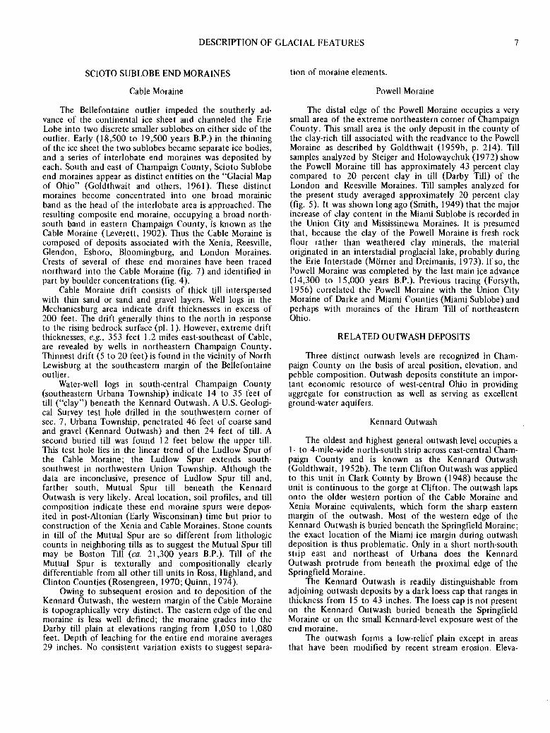
SCIOTO SUBLOBE END MORAINES
Cable Moraine
The Bellefontaine outlier impeded the southerly ad-vance of the continental ice sheet and channeled the Erie Lobe into two discrete smaller sublobes on either side of the outlier. Early {l 8,500 to 19,500 years B.P.) in the thinning of the ice sheet the two sublobes became separate ice bodies, and a series of interlobate end moraines was deposited by each. South and east of Champaign County, Scioto Sublobe end moraines appear as distinct entities on the "Glacial Map of Ohio" (Goldthwait and others, 1961 ). These distinct moraines become concentrated into one broad morainic band as the head of the interlobate area is approached. The resulting composite end moraine, occupying a broad north-south band in eastern Champaign County, is known as the Cable Moraine (Leverett, 1902). Thus the Cable Moraine is composed of deposits associated with the Xenia, Reesville, Glendon, Esboro, Bloomingburg, and London Moraines. Crests of several of these end moraines have been traced northward into the Cable Moraine (fig. 7) and identified in part by boulder concentrations (fig. 4 ).
Cable Moraine drift consists of thick till interspersed with thin sand or sand and gravel layers. Well logs in the Mechanicsburg area indicate drift thicknesses in excess of 200 feet. The drift generally thins to the north in response to the rising bedrock surface (pl. 1 ). However, extreme drift thicknesses, e.g., 353 feet 1.2 miles east-southeast of Cable, are revealed by wells in northeastern Champaign County. Thinnest drift (5 to 20 feet) is found in the vicinity of North Lewisburg at the southeastern margin of the Bellefontaine outlier.
Water-well logs in south-central Champaign County (southeastern Urbana Township) indicate 14 to 35 feet of till ("clay") beneath the Kennard Outwash. A U.S. Geologi-cal Survey test hole drilled in the southwestern corner of sec. 7, Urbana Township, penetrated 46 feet of coarse sand and gravel (Kennard Outwash) and then 24 feet of till. A second buried till was found 12 feet below the upper till. This test hole lies in the linear trend of the Ludlow Spur of the Cable Moraine; the Ludlow Spur extends south-southwest in northwestern Union Township. Although the data are inconclusive, presence of Ludlow Spur till and, farther south, Mutual Spur till beneath the Kennard Out wash is very likely. Areal location, soil profiles, and till composition indicate these end moraine spurs were depos-ited in post-Altonian (Early Wisconsinan) time but prior to construction of the Xenia and Cable Moraines. Stone counts in till of the Mutual Spur are so different from lithologic counts in neighboring tills as to suggest the Mutual Spur till may be Boston Till (ca. 21,300 years B.P.). Till of the Mutual Spur is texturally and compositionally clearly differentiable from all other till units in Ross, Highland, and Clinton Counties (Rosengreen, 1970; Quinn, 1974 ).
Owing to subsequent erosion and to deposition of the Kennard Outwash, the western margin of the Cable Moraine is topographically very distinct. The eastern edge of the end moraine is less well defined; the moraine grades into the Darby till plain at elevations ranging from 1,050 to 1,080 feet. Depth of leaching for the entire end moraine averages 29 inches. No consistent variation exists to suggest separa-
tion of moraine elements.
Powell Moraine
The distal edge of the Powell Moraine occupies a very small area of the extreme northeastern corner of Champaign County. This small area is the only deposit in the county of the clay-rich till associated with the readvance to the Powell Moraine as described by Goldthwait (1959b, p. 214). Till samples analyzed by Steiger and Holowaychuk {l 972) show the Powell Moraine till has approximately 43 percent clay compared to 20 percent clay in till (Darby Till) of the London and Reesville Moraines. Till samples analyzed for the present study averaged approximately 20 percent clay (fig. 5). It was shown long ago (Smith, 1949) that the major increase of clay content in the Miami Sublobe is recorded in the Union City and Mississinewa Moraines. It is presumed that, because the clay of the Powell Moraine is fresh rock flour rather than weathered clay minerals, the material originated in an interstadial proglacial lake, probably during the Erie Interstade (Morner and Dreimanis, 1973). If so, the Powell Moraine was completed by the last main ice advance (14,300 to 15,000 years B.P.). Previous tracing (Forsyth, 1956) correlated the Powell Moraine with the Union City Moraine of Darke and Miami Counties (Miami Sublobe) and perhaps with moraines of the Hiram Till of northeastern Ohio.
RELATED OUTWASH DEPOSITS
Three distinct outwash levels are recognized in Cham-paign County on the basis of areal position, elevation, and pebble composition. Outwash deposits constitute an impor-tant economic resource of west-central Ohio in providing aggregate for construction as well as serving as excellent ground-water aquifers.
Kennard Outwash
The oldest and highest general outwash level occupies a 1- to 4-mile-wide north-south strip across east-central Cham-paign County and is known as the Kennard Outwash (Goldthwait, 1952b). The term Clifton Outwash was applied to this unit in Clark County by Brown {l 948) because the unit is continuous to the gorge at Clifton. The outwash laps onto the older western portion of the Cable Moraine and Xenia Moraine equivalents, which form the sharp eastern margin of the outwash. Most of the western edge of the Kennard Outwash is buried beneath the Springfield Moraine; the exact location of the Miami ice margin during outwash deposition is thus problematic. Only in a short north-south strip east and northeast of Urbana does the Kennard Outwash protrude from beneath the proximal edge of the Springfield Moraine.
The Kennard Outwash is readily distinguishable from adjoining outwash deposits by a dark loess cap that ranges in thickness from 15 to 43 inches. The loess cap is not present on the Kennard Outwash buried beneath the Springfield Moraine or on the small Kennard-level exposure west of the end moraine.
The outwash forms a low-relief plain except in areas that have been modified by recent stream erosion. Eleva-

8 GLACIAL GEOLOGY OF CHAMPAIGN COUNTY
100%CLAY
e Cable Moraine ( 13 samples)
0 Miami Sublobe ground moraine ( 11 samples)
& West Liberty Moraine (4 samples)
(!] Springfield Moraine ( 7 samples)
FIGURE 5.-Three-component diagram showing the mean particle-size distributions for 35 till samples from Champaign County.
tions on the outwash surface range from 1,230 feet at the Logan County line to about 1,100 feet at the Clark County boundary. The Kennard surface slopes southward at approx-imately 8 feet per mile in Logan and Champaign Counties, but decreases gradually in gradient to about 4 feet per mile in Clark County. This change in gradient is due to the proximity of the bedrock constriction and terminal barrier near Clifton in northern Greene County.
Kennard Outwash forms a 33-mile-long belt from southern Logan County south through Champaign and Clark Counties to Clifton Gorge in northern Greene County. The narrow confined high distribution of the outwash indicates that the deposit had to form when the Miami Sublobe stood near the present western margin of the Springfield Moraine. Only with the Miami ice in this position could lower westerly and southwesterly drainage be blocked. Thus, during an early stage (dated at about 18,500 years B.P. by Dreimanis and Goldthwait, 1973) of Late Wisconsinan retreat, all meltwater from the two sublobes was channeled into this narrow belt between the sublobes. At the southern limit of the Kennard Outwash, Clifton Gorge displays giant
potholes in and above the limits of the gorge, attesting to the huge annual floods of meltwater and outwash that formed the Kennard level.
The mean depth of carbonate leaching for the Kennard Outwash is 39 inches. This is the highest mean value in the county and reflects the age of the outwash, the porosity of the materials, and the added thickness of the loess cap (Rosengreen, 1970, p. 34).
Southward tracing of the Xenia and Springfield Mo-raines enclosing the Kennard Outwash associates the final deposition of the outwash with construction of the well-dated (ca. 18,000 years B.P.) Cuba Moraine (Dreimanis and Goldthwait, 1973) and deposition of the loess-covered Kingston Outwash in the Scioto River valley (Quinn, 1974).
Urbana {Intermediate) Outwash
Urbana or Intermediate Outwash is present in two distinct geomorphic settings in Champaign County. East of the Springfield Moraine in northeastern Salem Township and in the Buck Creek valley of southwestern Union Township
ti

DESCRIPTION OF GLACIAL FEATURES 9
(Enon Outwash of Brown, 1948) the higher Kennard Outwash has been cut to an intermediate level. West of the Springfield Moraine and extending beneath the West Liberty Moraine is a continuous constructive Urbana Outwash level. Stone counts in the two areas indicate the outwash west of the end moraine had a Miami Sublobe origin, whereas the excavated levels east of the Springfield Moraine have a composition that approximates mixed Kennard Outwash pebble composition.
Average depth of leaching in the continuous portion of the outwash is 29 inches, which is nearly identical with depths of leaching in the bordering Springfield and West Liberty Moraines in spite of differences in permeability of the deposits.
Unlike the other outwash deposits in Champaign County, the Urbana Outwash has no associated ice-contact features yet identified. It is possible that the buried gravel of the till-over-gravel area and the associated buried kame field east of Springhills (northern Harrison Township) represent an Urbana Outwash source area, as suggested by Forsyth (1956). Where stripped of its till cover, the buried gravel surface east of Springhills is nearly gradational with the intermediate outwash level east of the Mad River valley.
In addition to stone counts, areal position suggests a Miami Sublobe origin for the Urbana Outwash. If Scioto ice had supplied material, the ice margin would have had to advance over the Kennard Outwash. Some till undoubtedly would have been deposited during subsequent retreat of the Scioto Sublobe. However, no till is present on the eastern margin of the Kennard Outwash level in east-central Cham-paign County. Total erosional removal of till cover over an area the size of the exposed Kennard Outwash seems highly unlikely.
The time of formation of the cut Urbana Outwash levels down Kings Creek and Buck Creek east of the Springfield Moraine is uncertain. During early stages of retreat from the Springfield Moraine, meltwater from the wasting Miami ice may have cut the Kennard Outwash to an intermediate level. Alternatively, formation of the cut terraces may have occurred synchronously with deposition of the Urbana Outwash west of the end moraine.
Mad River Valley Train
The Mad River rises about 3 miles northwest of Zanesfield, in Logan County, and flows southerly through Champaign and Clark Counties to Springfield, where it swings southwesterly and joins the Great Miami River at Dayton in Montgomery County. Throughout its length, the Mad River valley contains a thick continuous outwash deposit. This most extensive outwash accumulation in Ohio, the Mad River Valley Train (Goldthwait, 1952b ), is hydro-logically continuous with the Urbana and Kennard Out-washes to the east.
The Mad River Valley Train forms a north-south I- to 3-mile-wide band through central Champaign County. The mean depth of leaching of carbonates is 35 inches, reflecting the well-drained nature of the outwash plain and the fluctuating high water table. Stone counts indicate that materials from both sublobes were contributed during formation of the Mad River outwash.
Ice-contact features of both sublobes head tributary deposits of the Mad River Valley Train. Tracing of these tributary deposits to their ice-contact sources is important in
correlating ice-margin positions of the sublobes. The ice-margin positions delineated by the ice-contact features are in line with and correlated with the Farmersville and Reesville Moraines. Radiocarbon dating of material from the Reesville Moraine in southern Ohio indicates that the end moraine formed just after 17 ,200 years B.P. Thus the Mad River Valley Train ceased construction approximately 17,200 years B.P. and is presumably correlative (Kempton and Goldthwait, 1959) with the Circleville Outwash in the Scioto River valley and the Carroll Outwash in the Hocking River valley.
The gradient of the Mad River Valley Train is steeper, ranging between 8 and 10 feet per mile, than that of the Kennard Outwash. Well logs and geophysical measurements (Janssens, 1964) indicate the southern portion of the valley train in Champaign County is cut into bedrock and averages about 60 feet in thickness. In northern Champaign County, "clay" (till) is encountered in most water wells which penetrate Mad River gravels, at depths averaging 75 feet.
Cedar Bog (Cedar Swamp State Memorial), in secs. 31 and 32 of Urbana Township in south-central Champaign County, is a remnant of great swampy tracts that probably developed soon after deposition of the Mad River Outwash. Small bogs that have been drained and modified are present elsewhere on the outwash surface. A typical bog is located at the head of the East Fork valley along Ohio Route 4, 3.1 miles west of Mechanicsburg. All the ditches in these shallow basins expose up to I foot of clay and silt washed from surrounding low slopes in late-glacial time. Overlying this basal unit is about 1 foot of marl which dates from about 9,000 years B.P. and contains mollusks which indicate a shallow open-water environment. Capping the local stratig-raphy is a 1- to 4-foot peat unit which represents postglacial forest encroachment.
ICE-CONTACT FEATURES
Numerous isolated deposits of stratified ice-contact drift are found in Champaign County. In the extreme northeastern comer of Urbana Township, 2.5 miles north-east of Urbana, the Indian Mound moulin kame lies surrounded by outwash and lacustrine sediments. Small borrow pits on the southern portion of the kame expose sand and gravel that is covered with I 0 to 12 inches of loess. A second moulin kame is located 3 miles south-southwest of Indian Mound within the ground moraine east of the Springfield Moraine. This kame has on its northern flank a large gravel pit that exposed 30 feet of stratified sand and gravel capped by 2 to 4 feet of till, indicating that the kame was overridden. The trend of the long axis of both moulin kames is approximately N 15° E. North of Indian Mound, portions of the ground moraine east of the Springfield Moraine are elongated in minor ridges along a similar trend. This similarity suggests that these deposits were developed in association with a major fracture system within thin ice as the sublobes began to separate long before Kennard Out-wash was deposited. Although stratigraphically the moulin kames have not been shown to extend beneath the surround-ing outwash or lacustrine deposits, their areal positions, compositions, and exposed stratigraphy suggest that they are the oldest exposed washed deposits of either sublobe in Champaign County. If supplementary radiocarbon dates in other counties are correct, the moulin kames formed 18,500 to 19,500 years B.P.

10 GLACIAL GEOLOGY OF CHAMPAIGN COUNTY
Two kame terraces, associated with deposition of the Kennard Outwash, lie on the distal edge of the Cable Moraine. The northernmost terrace, 1.5 miles west of Mingo, lies only slightly above the level of the outwash. The southernmost terrace is on the south side of East Fork valley, 4.0 miles southwest of Mechanicsburg. This kame terrace is about 25 feet higher than the nearby Kennard Outwash terrace. Both deposits probably formed synchro-nously with the Kennard Outwash along ice tongues that extended down preexisting subglacial drainage valleys. Cor-relation of the kame terraces with the Kennard Outwash places terrace formation at shortly after 18,200 years B.P.
The most extensive area of kame topography in the county is in north-central Harrison Township west of the Mad River valley. This region is the southern portion of a large area of kames that covers nearly 200 square miles of Logan and Champaign Counties (Goldthwait, 1955; Forsyth, 1956). The kame field and outwash are covered with as much as 20 feet of till. In a small gravel pit 0.2 mile south of Springhills a probable Fox B-zone soil is present in pods at the top of the buried gravel. If this soil formed prior to deposition of the overlying till, soil formation occurred in less than 1,000 years (between 18,200 and 17 ,300 years B.P.).
Two buried ridges of stratified drift in Harrison Town-ship have been identified as eskers. The smaller esker, 1.6 miles southeast of Springhills, forms a prominent ridge marking the southeastern extremity of the buried kame field. Several small borrow pits on the west flank of the esker expose stratified sand and gravel. The larger esker, 1.5 miles southwest of Springhills, is a I-mile-long sinuous ridge of till-capped gravel extending southwest from the buried kame field. A large gravel pit in the extreme northern end of the esker, west of Calland Road, exposes the stratified drift that comprises the esker. To the south, augerings and well logs indicate gravel beneath a till cover. These gravel zones formed during the same decaying-ice situation that produced the ice-contact features approximately l 8,000 years B.P.
Karnes southeast of Kiser Lake head the Nettle Creek arm of the Mad River Valley Train, thus defining the Miami Sublobe marginal position during completion of outwash deposition. Stratified drift is exposed in a small sanitary landfill within the kame field. Karnes north and east of Mingo and Cable also head tributary deposits of the Mad River Outwash on the east (Scioto Sublobe) side. An isolated kame, 3.0 miles southwest of Mechanicsburg, is probably associated with the formation approximately l 7,200 years B.P. of the East Fork tributary of the Mad River Valley Train. This kame contains the largest masses of well-cemented young gravel found in the region.
BOULDERS
Boulder concentrations in Champaign County are plotted in figure 4. The extensive boulder assemblages associated with the Farmersville Moraine were recognized by Leverett (1902) and named the Farmersville Boulder Belt. Approximately 90 percent of the boulders have Canadian crystalline lithologies; the remainder are of Ohio bedrock. The erratics are as much as 6 feet in diameter, but average about 1 foot. Clearing of agricultural land has resulted in concentration of quantities of these boulders along fence lines, in woodlands, and in ditches.
Roadcut and stream-cut exposures and drill records
indicate that the boulders are confined primarily to the surface and the uppermost few feet of till. Because glaciers have a very poor capacity for sorting, a selective concentra-tion of boulders must have occurred before the material became incorporated into an advancing ice sheet. Because the boulders are nearly all found in the uppermost 5 feet of till, they were probably transported on the ice surface and are ablation moraine. The boulders display no telltale features that would suggest intense eolian winnowing or any other in situ sorting mechanism. Also, an extensive inte-grated stream channel system is absent. Thus the Miami Sublobe must have readvanced to the Farmersville Moraine position heavily laden with boulders but with a relatively small amount of finer till. How the ice selectively incorpo-rated such an anomalous concentration of boulders and why the composition of the erratics is heavily weighted toward crystalline lithologies from 400 to 600 miles away remain conjectural. One earlier suggestion (Goldthwait and Rosen-green, 1969) was that periglacial concentration by water or chemical weathering in northern crystalline rock areas could have supplied the advancing ice sheet with boulders. This suggestion fails to explain why the boulder belt was formed following a restricted Late Wisconsinan retreat of the ice sheet. More plausible is the suggestion (Goldthwait, 1969) that "surface concentrations of scattered boulders without equivalent till matrix [are] similar to the debris pattern [ s] left by recently surging glaciers and might represent just such lobate activity."
Throughout the Cable Moraine no sharply defined continuous belt of boulders occurs. Boulders of the Scioto Sublobe · range between 75 and 85 percent crystalline lithologies from Canada. There are more Ohio bedrock erratics in deposits of the Scioto Sublobe than in the Farmersville Boulder Belt. As can be seen in figure 4, heaviest boulder concentrations on the Cable Moraine are in the central, higher portions of the end moraine, probably in association with the Glendon, Esboro, and Bloomingburg elements of the composite end moraine; these elements also have localized extensive boulder concentrations. This boul-der distribution suggests that after a retreat the Scioto Sublobe surged, with an anomalous load of boulders, in a manner similar to the Miami Sublobe readvance to the Farmersville Moraine. In the Scioto Sublobe area southeast of Champaign County, only the Bloomingburg Moraine and portions of the Reesville and Glendon Moraines display high concentrations of boulders. This suggests that the Farmers-ville Moraine, or its bouldery final phase, is the time equivalent of the Reesville-to-Bloomingburg Moraines of the Scioto Sublobe. The extension of the boulder belt westward beyond the Farmersville Moraine and into Miami County may be the equivalent of the Glendon, Esboro, and Bloomingburg Moraines because the Miami Sublobe has no equivalent moraine topography.
LACUSTRINE DEPOSITS
Two miles northeast of Urbana, at the surface in northeastern Urbana Township, thinly laminated fine sand, silt, and clay indicate the presence of a lacustrine plain. Exposures in drainage ditches, seismic soundings (Janssens, 1964), and water-well logs show that the lake deposits are 4 to 15 feet thick and are underlain by bouldery clay (till) and outwash.
Augerings and well logs show that the lacustrine beds

DESCRIPTION OF GLACIAL FEATURES 11
are stratigraphically younger than the bordering Kennard Outwash. The lake sediments lap onto the Springfield Moraine and the ground moraine east of the end moraine. Meltwater ponded between the end moraine and the westerly sloping Kennard surface. The lake drained to the south through a channel cut in the ground moraine. Such ponding probably ceased when retreat of the Miami Sublobe terminated easterly meltwater drainage and eliminated the local elevated water table.
DIRECTIONAL INDICATORS
Striae
Only two exposures of striae have been measured in Champaign County. Leverett (1902) plotted striae with a bearing of "E 10° N" in a now-abandoned stone quarry on Stone Quarry Road, 4.0 miles east-northeast of Urbana (pl. l ). A bedrock exposure more extensive than exists today allowed Leverett to deduce that "eastward movement is clearly indicated on the rock surface, whose prominences show plainly that their west side is the stoss side." Poorly developed striae have been exposed recently on the Ty-mochtee Dolomite (Silurian) in the bottom of the American Aggregates gravel pit, 2.0 miles west-southwest of Cable (pl. 1 ). The trend of the striae ranges from N 38° E to N 31 ° E. Crag-and-tail features are not present to indicate direction of ice movement, but westerly movement is clearly indicated in all pebble lithologies in the overlying outwash. This indicates that both lobes covered this Kennard Plain area at one time or another.
Till fabrics
Thirteen determinations of till fabric are plotted as rose diagrams in figure 6. lbe till-fabric trends agree very well with directions of movement determined by striae. The channeling effect around the topographically high outlier is shown clearly by the long-axis orientations. The fabrics, in conjunction with the pebble counts and continuity of the arcuate end moraines, clearly differentiate Miami Sublobe and Scioto Sublobe materials. The till under outwash, the striae, and the moraine-crest spurs on the west side of the Cable Moraine seem to indicate expansion of the Scioto Sublobe west of its exposed drift limit in the southern half of Champaign County prior to the Xenia-Cable Moraine stand (ca. 18,200 years B.P.) and during deposition of the Boston Till (ca. 21,400 years B.P.).
SURFACE SOILS
Till-soil associations
Five till-soil associations of Late Wisconsinan age are recognized in western Ohio (Forsyth, 1965). These associ-ations are distinguished by differences in: (1) loess cover, (2) amount of clay in the B horizon, (3) amount of clay in the C horizon, and ( 4) depth of the soil profile. These groups occur as irregular bands, generally parallel to the end moraines. Boundaries between most till-soil associations are caused by major differences, generally associated with major ice readvances, in parent materials.
The boundary between the Miami 6A and Miami 60 soils transects Champaign County diagonally north-south
0 2 4 miles t-r'-r-' O 2 4 kilometers
FIGURE 6.-Rose diagrams of till fabrics and locations of samples in Champaign County. End moraines indicated by pattern.
through deposits of both sublobes. The significant character-istics of these till-soil associations are given in table 2.
The contact between the Miami 6A and 60 soils has. been placed along the distal edge of the Farmersville Moraine and generally along the distal edge of the Reesville Moraine (Forsyth, 1965), with Miami 60 soils in the area between the moraines. Forsyth indicates that the age differences between the two soils are not of stadia! proportions. We concur for three reasons: (1) although the soil differences are distinct in some areas, the types do overlap, (2) presence of a loess cap does change the rate of soil formation (Rosen green, 1970), and (3) radiocarbon dates in central and western Ohio indicate that a period of only about 4,000 years was available for the entire Late Wisconsinan retreat. Additionally, only about 1,000 years elapsed between deposition of the Cuba Moraine and deposition of the Reesville Moraine. Thus no major time interval was available for pedologic development.
TABLE 2.-Significant characteristics of the major till-soi/ associations in Champaign County'
Soil Thickness Depth of Clay percentage Associated of loess leaching B c till unit name (in) (in) . horizon horizon
Miami 6A generally none 16-30 40-50 15-27 Darby Till Miami60 18 20-40 33-40 15-27 Caesar Till
1 Adapted from Forsyth (1965).

12 GLACIAL GEOLOGY OF CHAMPAIGN COUNTY
Wilding and others (1964) found no significant differ-ences in composition of parent materials of 6A soils (Darby Till) and 60 soils (Caesar Till) in western Ohio. likewise no large-scale pedologic differences were detected by Ritchie and others (1971) while mapping for the soil survey of Champaign County or by the authors during the present study. Under revised soil terminology, areas formerly mapped as Miami 6A and 60 are now included under the term Miamian (for well-drained sites).
Loess cover
Forsyth (1965) stated that significant accumulations of loess in west-central Ohio are limited to areas characterized by Miami 60 soils. In Champaign County, only the exposed Kennard Outwash surface east of the Springfield Moraine displays a thick (15 to 43 inches) continuous dark-brown (7 .5 YR 4/4) loess cap. The loess cover is present over the entire outwash surface, including the area between the Ludlow and Mutual Spurs of the Cable Moraine. All younger outwash levels and associated end moraines lack a distin-guishable loess cover.
The loess cap was not found on Kennard Outwash beneath the Springfield Moraine. Two explanations are possible. First, loess may have been deposited on the entire Kennard Outwash surface but then was partially stripped when the Miami Sublobe advanced to form the Springfield Moraine. A second possibility is that the loess episode occurred after the readvance, when the Miami Sublobe stood near its easternmost limit. Thus the loess may have been deposited on the ice sheet and later redeposited or carried away by surface meltwater as the ice sheet wasted. In either case, much loess deposition had to occur after separation of the sublobes (ca. 19,000 years B.P.) and before construction of the Reesville and Farmersville Moraines (ca. 17,000 years B.P.).
BURIED SOILS
A buried soil, developed in outwash gravel beneath 2 to 10 feet of till, has been observed at several localities in western Ohio (Goldthwait, 1952b, 1955, 1959a). The leached buried soils typically exhibit: (1) white ghosts of former calcareous materials, (2) a distinctive reddish-brown matrix, and (3) clay enrichment. In some cases leached reddish pods of a paleosol have been incorporated into the overlying till.
Two explanations have been offered to account for the buried soils. Goldthwait (1952b, 1955, 1959a) suggested, after field conferences with Ohio soil experts, that the leached zones are true paleosols, developed during inter-stadial periods and thus implying periods of subaerial exposure during their formation. A second hypothesis (Gooding and others, 1959) holds that these soils are areas of clay concentration, beta layers, developed synchronously with the present surface soils through leaching, movement down through the till, and concentration of fine materials where percolating ground water intersects underlying grav-els.
Four exposures of buried soils have been described from Champaign County. A small gravel pit in the ground moraine at Hillard Farm, 3.8 miles southeast of Urbana, in south-eastern Urbana Township, exposed 3 feet of till that was
leached to 30 inches. Beneath the till, in bedded calcareous gravel (Kennard Outwash), were patches of leached red-brown soil (Goldthwait, 1955). In a now-abandoned gravel pit 0.3 mile south of Springhills in northwestern Champaign County, pods of soil have been exposed beneath 2 to 4 feet of till. The soil is located just above the gravel surface of a buried kame (Goldthwait, 1955). The only paleosol locality still exposed in the county is in this gravel pit.
In a burial trench in the Urbana sanitary landfill, in the Springfield Moraine, Janssens (1964) described 2 to 5 feet of till overlying thick outwash gravel. The uppermost 15 inches of the gravel exhibited coloration and leaching characteristic of a paleosol. There was a similar exposure of the leached zone along Dallas Road (sec. 25, Urbana Township} in southern Champaign County.
Interpretation of these zones as true paleosols or as areas of clay concentration does profoundly affect the interpretation of the glacial history of west-central Ohio. The critical factor is the length of time necessary for formation of such paleosols. Studies of ten stratigraphic sections from buried soil localities (G. Hariharan, unpub-lished seminar report for R. P. Goldthwait) compared the clay mineralogy of the topsoils and of buried paleosols (using parent materials as standards). One of these samples was from Harrison Township and four others were from counties contiguous to Champaign. lliite was found to be the dominant clay material in both the present soils and the paleosols. Vermiculite is more abundant in the topsoils than in the buried soils, but chlorite is relatively more abundant in the paleosols. Presence of minor amounts of chlorite (0.02-0.38 percent) in the paleosols may indicate little true weathering. The total amount of clay in the buried soils was surprisingly small. The evidence fails to substantiate a long period of subaerial exposure and pedologic development. The chlorite may have developed in the interval between 18 ,200 and 1 7 ,300 years B .P.
Heavy-mineral analyses from the same ten localities (P. J. Barrett, unpublished seminar report for R. P. Goldthwait) rated stable minerals (e.g., zircon, rutile, tourmaline, mona-zite, and garnet) against vulnerable minerals (e.g., amphibole and pyroxene) and primary magnetite-ilmenite against sec-ondary limonite-hematite. Samples from the true deep-buried paleosol at Sidney showed sharp differences in the pyroxene/amphibole ratio within the paleosol. No sequence in any other sample displayed any differences suggestive of the development of a true paleosol.
As suggested earlier, the Springhills buried kame field and the buried outwash east of the kame field may be associated with the Urbana Outwash. If this is true and the buried soil at Springhills is a true paleosol, the Urbana Outwash would have to be of Early Wisconsinan age. The paleosol would have had to develop synchronously with the buried paleosol at Sidney, where the material is dated as having formed between 50,000 and 22,500 years B.P. (Forsyth, 1965). Therefore all deposits stratigraphically older than the buried soil at Springhills would have to be Early Wisconsinan. Thus the Kennard Outwash and the western spurs of the Cable Moraine which are overlain by the Kennard Outwash would have to have been deposited before the Sidney soil interval. However, because the Kennard Outwash lacks till cover over half its extent, it seems highly unlikely from regional evidence that it has been exposed for 50,000 years. Similarly, regional evidence argues

RESULTS OF FIELD AND LABORATORY ANALYSES 13
against consideration of these buried soils as true paleosols.
RESULTS OF FIELD AND LABORATORY ANALYSES
STONE COUNTS
Data from 79 stone counts indicate distinctive compo-sitional differences in tills and outwashes of Champaign County. Generally till deposited by the Miami Sublobe has 4 to 6 percent more limestone and crystalline pebbles and 5 to 6 percent fewer dolomite pebbles than does western Scioto Sublobe till. Percentages of elastic pebbles (siltstone, shale, and sandstone) average 2 percent higher in the Scioto Sublobe deposits. Total carbonate percentages are 2 to 3 percent higher in the Cable Moraine than in the Miami Sublobe end moraines. Cable Moraine stone counts average 80 percent dolomite, whereas the West Liberty, Springfield, and Farmersville Moraines average 73 percent. Percentages of limestone pebbles range from 10 percent in the Spring-field Moraine to I 3 percent in the Miami Sublobe ground moraine to I 6 percent in the Farmersville Moraine. Scioto Sublobe tills average 9 percent limestone pebbles, a consist-ently lower value than for Miami Sublobe tills.
Crystalline-pebble percentages are significantly higher in the Springfield (I I percent) and Farmersville (IO percent) Moraines than in the Cable (6 percent) Moraine. Within the Cable Moraine local areas of anomalously high crystalline-pebble percentages exist in association with high boulder concentrations. Miami Sublobe tills average about l percent elastic lithologies; Scioto Sublobe tills contain about 3 percent elastics. Chert occurs as approximately l percent of pebbles in all tills in Champaign County.
Thirty-seven pebble counts in outwashes reflect the relative contributions of material from each sublobe during formation of each outwash level. Kennard Outwash averages 80 percent dolomite, 9 percent limestone, 8 percent crystallines, 2 percent elastics, and I percent chert. On the basis of similarity of stone counts in Cable Moraine till, it appears the Kennard Outwash was formed primarily of materials associated with the Scioto Sublobe. This is consistent with the location of ice-contact features known to be associated with the Kennard Outwash. In two pits dug in the gravel exposed west of the Springfield Moraine, northeast of Urbana, stone counts average 79 percent dolomite, 11 percent limestone, 6 percent crystallines, 3 percent elastics, and l percent chert. Although certainly not proof, these values suggest that this gravel is Kennard Outwash protruding from beneath the proximal edge of the Springfield Moraine.
Percentages of carbonate pebbles (72 percent dolomite, 16 percent limestone) in the Urbana Outwash clearly distinguish the intermediate-level outwash from the Kennard Outwash. Crystalline (9 percent), elastic (2 percent), and chert (I percent) percentages are similar to Kennard Outwash values. Although.no definite source of this outwash is known, stone-count similarities with tills of the Miami Sublobe indicate that, unlike the other Champaign County outwashes, the primary source of material for the Urbana Outwash was the Miami Sublobe.
Three stone counts in the buried kame gravel near Springhills average 74 percent dolomite, I 2 percent lime-stone, I l percent crystallines, 2 percent elastics, and I
percent chert. Obvious similarities to Urbana Outwash suggest an associated Miami Sublobe ice-contact source. Stone counts taken on the cut Urbana Outwash levels, east of the Springfield Moraine, average 80 percent dolomite, 10 percent limestone, 8 percent crystallines, 2 percent elastics, and I percent chert. These values are so similar to percentages for the Kennard Outwash that these intermedi-ate levels are certainly cut levels in the Kennard Outwash.
Karnes head Mad River Valley Train deposits in both sublobes. Thus Mad River outwash gravel should have a composition indicative of the amounts of material supplied from each sublobe. The outwash averages 8I percent dolomite, 5 percent limestone, 7 percent crystallines, 4 percent elastics, and 3 percent chert. It appears that the Scioto Sublobe provided the bulk of the material during formation of this outwash level. Chert percentages are consistently higher in the Mad River Valley Train than in the older outwashes. The chert was probably derived from limestones that form part of the Bellefontaine outlier.
CALCITE-DOLOMITE ANALYSES
Sixty-one till samples were analyzed for carbonate content by the Chittick gasometric method (Dreimanis, 1962). Although these samples are a minimal number to adequately cover Champaign County, significant differences are indicated.
Thirty-seven Miami Sublobe till samples indicate a total carbonate percentage that ranges from 24 to 54 percent, with a mean of 40.7 percent. The Springfield Moraine till is the most calcareous in the county, averaging 4 7 .2 percent total carbonate. The West Liberty and Farmersville Moraines average 36.7 percent total carbonate. Calcite percentages range from I 1.7 percent in the Farmersville Moraine to I4.9 percent in the West Liberty and Springfield Moraines. The average calcite percentage for the Miami Sublobe tills is 13 .8 percent. Dolomite values average 25.4 percent for the Miami tills, with the highest (29. 7) percentage in the Springfield Moraine. Calcite/dolomite ratios range from 0.59 for the West Liberty Moraine to 0.48 for the Farmersville Moraine. The mean calcite/dolomite ratio for the Miami Sublobe tills is 0.52.
Twenty-four till samples from the Scioto Sublobe display total carbonate values between 16 and 52 percent, with a mean value of 35 .0 percent, significantly lower than that for the Miami Sublobe drift. The Cable Moraine averages I 0.0 percent calcite and 23.4 percent dolomite; both values are lower than the means for the Miami Sublobe tills. The calcite/dolomite ratio averages 0.48 for the Cable Moraine tills. Although the averages differ, it is evident that specific samples have a broad range of overlap.
GRANULOMETRIC ANALYSES
Plots of average sand-silt-clay percentages (fig. 5) indicate a striking similarity in particle-size distribution of tills throughout Champaign County. Average till texture for all moraines in the county falls within the silt loam category of the U.S. Department of Agriculture textural classification.
Although minor textural variations are present in the tills within Champaign County, particle-size distribution appears to be largely independent of compositional varia-tions.

14 GLACIAL GEOLOGY OF CHAMPAIGN COUNTY
SEQUENCE AND CHRONOLOGY
Many glacial geologists have attempted to correlate moraines between the Miami and Scioto Sublobes. Boulder concentrations, depth of loess cover, granulometric analyses, end moraine crests, stone counts, ERTS imagery, and depth of carbonate leaching have all been used in interlobate correlation.
Leverett (1902) recognized that loess cover ended or became patchy north of the Farmersville and Reesville Moraines. Goldthwait (1968) confirmed this relationship through hundreds of soil-auger sites and interpreted this loess break as indicating that loess deposition ceased as the ice sheet simultaneously retreated from the Farmersville and Reesville Moraines. On the proximal side of the end moraines, loess averages less than 9 inches in thickness, whereas south of the moraines an average of 25 inches of loess is present. This loess boundary has been clearly defined in Highland (Rosengreen, 1970), Clinton (Teller, 1964 ), and Ross (Quinn, 1974) Counties.
The Camden Moraine, southwest of Champaign County in the Miami Sublobe, consists of numerous discontinuous elements. Early tracing of the moraine elements northward through Clark and Montgomery Counties into Champaign County suggested a possible correlation with the Springfield Moraine. Regular identifiable loess analogous to the loess between the Cuba and Reesville Moraines of the Scioto Sublobe was not, in this study, found between the Farmers-ville and Camden-Springfield Moraines.
Dreimanis and Goldthwait (1973) indicated that the Cuba and Xenia Moraines may have been in part contempo-raneous and probably were deposited shortly before and during deposition of the Kennard Outwash as the interlobate area opened. Radiocarbon dating (W-91, W-331, Y-448,and OWU-331) indicates the end moraines were constructed during a readvance of the Scioto Sublobe (18,000 to 18,500 years B.P.). This readvance overran earlier Wisconsinan moraines in Clinton, Highland, and Ross Counties. Thus, by end moraine tracing and correlation, the Miami Sublobe ice margin must have stood in the general position of the Springfield Moraine about 18,200 years B.P. Two spurs of the Cable Moraine, south and west of Mutual, were partially buried by the Kennard Outwash and therefore probably represent deposits of the early advance west of the Xenia Moraine. The narrow interlobate area in which the Kennard Outwash was deposited received a thick loess cover before significant retreat of the sublobes.
A boulder belt and the associated Farmersville Moraine clearly define the Miami Sublobe position during deposition of the Mad River Valley Train. Loess deposits of south-western Ohio (Goldthwait, 1968) indicate that the ice-margin positions at the Farmersville and Reesville Moraines were occupied synchronously. Boulder concentration indi-cates that the Farmersville and recessional phases associated with it correlate with the Reesville, Glendon, Esboro, and Bloomingburg positions. Therefore, within the composite Cable Moraine, kames that head deposits of the Mad River Valley Train must delineate the Reesville-to-Bloomingburg positions. No outstanding analogous Scioto Sublobe boulder belt was found on the Cable Moraine; the boulder concentra-tions have limited areal extent and seem to be restricted to the Reesville-to-Bloomingburg crests (figs. 4, 7). The posi-tion of the Bloomingburg Moraine, the most bouldery end moraine of the Scioto Sublobe, is not clearly defined in its
continuation within the Cable Moraine. However, the single crest with the most continuous boulders extends from 1.0 mile northwest of Mechanicsburg to 1.5 miles east of Middletown (fig. 7). This crest has been mapped as the Bloomingburg crest within the Cable Moraine and dated at approximately 16,000 years B.P.
Figure 7 shows that the crests of the Cable Moraine display two distinct trends. The majority of the crests trend nearly north-south, especially in the eastern half of the composite end moraine. In the western portions of the end moraine, crest trend ranges between northwest-southeast and northeast-southwest. Several crests, e.g., the crest 1.0 mile southeast of Mutual, show more than one orientation. Topographic rise and stone counts suggest that the north-east-southwest crests are present on earlier moraines which have been partially overridden by a later ice readvance with a different direction of movement. A minimal number of till-fabric analyses made during this study neither confirm
r-------
\ I f/ \ J I I B\ I 11 \ \~ I _ _l_.,_ ___ ~ _ _J
0 2 4 miles I I I I I 0 2 4 kilometers
- - - - Township boundary G Glendon Moraine
----- End moraine crest
L
B
London Moraine
Bloomingburg Moraine
E Esboro Moraine
R Reesville Moraine
V Vandervort Moraine
FIGURE 7.-Map of the Cable Moraine showing crests.

GLACIAL HISTORY 15
nor negate this idea. Portions of the first crest east of Mutual have been
mapped as the Reesville Moraine (pl. 1 ; fig. 7). This distinction is based on (I) position of the crest with respect to the kames heading the Mad River Valley Train tributary deposits, (2) limited boulder occurrences, and (3) tracing of crests from southeast of Champaign County. The eastern-most crest of the Cable Moraine can be traced clearly southeasterly through Clark and Madison Counties to the London Moraine. The Glendon and Esboro Moraines prob-ably do not have distinctive crests within the Cable Moraine but do fall within the boulder-strewn central area of the end moraine.
GLACIAL HISTORY
PRE-WISCONSINAN GLACIATION
Deposits of Kansan and Illinoian age in southwestern Ohio indicate that at least twice in pre-Wisconsinan time ice sheets spread across western Ohio. No surface deposits of these earlier glaciations have been detected in Champaign County. Drift that probably was deposited by these ice sheets has been penetrated by deep drilling in the buried valleys of the Teays River system in the western portion of the county.
Forsyth (1956) noted that deposits of Kansan and Illinoian age in southwestern Ohio lack a reentrant area as deep as the interlobate area associated with the Late Wisconsinan glaciation. She suggested that the earlier ice sheets were much thicker than the Wisconsinan ice mass. Therefore topographic highs, such as the Bellefontaine outlier, had less effect in impeding ice flow during the earlier glaciations.
EARLY WISCONSINAN GLACIATION
A buried soil, developed in till, has been described from 2 miles south of Sidney in adjacent Logan County (Forsyth, 1956; La Rocque and Forsyth, 1957). A log lying on the paleosol was dated at 23,000±800 years B.P. (W-188). Nearby, peat has been found between the till and paleosol, indicating cool interstadial conditions during the Sidney soil interval (Goldthwait and others, 1965). Forsyth (1965) indicated the peat is 22,500 to 50,000 years old. La Rocque (La Rocque and Forsyth, 1957) studied a fauna of pul-monate gastropods found in a thin silt zone below the till in which the paleosol developed. On the basis of the presence of two species which are absent from known Illinoian deposits, he suggested an Early Wisconsinan age for the till. No finite dates have been obtained from material below the stratigraphic position of the paleosol in west-central Ohio. Thus evidence at the Sidney cut indicates Early (Altonian) and Late (Woodfordian) Wisconsinan glaciations separated by a long Middle Wisconsinan period of soil formation.
Dreimanis and Goldthwait (1973) indicated that def-inite Early Wisconsinan deposits have been recognized only as far south as Columbus in the Scioto Sublobe and the Sidney cut in the eastern portion of the Miami Sublobe. Thus the possibility exists that the Early Wisconsinan ice
sheet did not advance as far south as Champaign County.
LATE WISCONSINAN GLACIATION
Although flow of the continental ice sheet was impeded by the bedrock uplands in Logan County, the ice was of sufficient thickness to cover the outlier (at least 23,000 years B.P.) and remain as a continuous ice sheet over western Ohio. Not until the ice stood near terminal positions for as long as 4,000 years (Rosengreen, 1970; Dreimanis and Goldthwait, 1973) did it begin to significantly thin and retreat. However, it may have constructed the western spurs of the Cable Moraine as the Scioto Sublobe extended far west over Clark and Greene Counties and deposited the Vandervort Moraine (Boston Till).
At least 19 ,000 years ago the Scioto and Miami Sublobes thinned, separated, and began to retreat, forming the glacial surface features that constitute the present landscape. The area of the county directly south of the upland was a zone of thin probably highly crevassed ice. As the ice in this area thinned, meltwater transported material into holes in the wasting ice, forming the moulin kames. Further melting and thinning resulted in physical separation of the two sublobes. Radiocarbon dating in southern Ohio indicates that the Scioto Sublobe deposited the w.estern portions of the Cable Moraine between 21 ,400 and 18,500 years B.P. The Miami Sublobe ice had retreated to a position just west of the present Springfield Moraine, without deposition of any morainic features. Vast amounts of meltwater and material from the wasting ice sheet became channeled in a narrow zone between the sublobes to form the high Kennard Outwash. Masses of ice up to several hundreds of feet in diameter became entrapped and buried in the outwash. These ice masses later melted to form the numerous kettles under the present Springfield Moraine. Drainage channels in some kettles indicate that some ice remained buried and intact until after deposition of the thin till that forms the Springfield Moraine. Exact position of the Miami Sublobe during deposition of the Kennard Outwash is uncertain because most of the western margin of the outwash is buried beneath end moraine. Interfingering till and outwash, exposed 2 to 8 miles south of Urbana, indicate an oscillating ice margin during deposition of the Kennard Outwash.
As portions of the outwash plain were completed, large quantities of fine outwash material dried seasonally and were transported by vigorous frontal winds. This material was deposited as loess on the Kennard surface and on the older moraine uplands of southwestern Ohio. As much as 15 inches of dark silt caps end moraines in Champaign County, and loess thickness increases southward into Clark and Greene Counties. If a thicker loess blanket was ever present on the end moraines of Champaign County, it has been eroded or concentrated in kettles and other depressions by runoff. Easterly draining meltwater became temporarily impounded in a shallow lake 2.0 miles northeast of Urbana. This lake drained southerly and probably ceased to exist when the Miami Sublobe retreated.
Miami Sublobe ice then readvanced over the Kennard Outwash as far east as the ground moraine east of the present Springfield Moraine. The loess cap continued to be deposited at this time. A significant halt during recession resulted in deposition of the thin till forming the Springfield Moraine.

16 GLACIAL GEOLOGY OF CHAMPAIGN COUNTY
The Miami Sublobe continued to retreat to a position west of the present West Liberty Moraine. Meltwater drainage through Clifton Gorge ceased as lower outlets were exposed. Exact position of the ice margin at this time is unknown owing to extensive valley cutting prior to deposi-tion of the Mad River Valley Train. Meltwater, choked with drift materials, streamed from the wasting Miami Sublobe ice and deposited the Urbana (Intermediate) Out wash. During cutting and during deposition of the outwash the ice margin oscillated, forming interfingering till and gravel, which is exposed along the proximal side of the West Liberty Moraine. A final phase of till deposition associated with this ice-margin position resulted in deposition of as much as 60 feet of till, forming the West Liberty Moraine and covering much of the Urbana Outwash east of the end moraine. The Urbana Outwash exposed between the Spring-field and West Liberty Moraines probably represents an exhumed surface. Thin patchy till overlies the Urbana Outwash south and southwest of Urbana. These till-over-gravel areas are probably remnants of a till unit that covered all the Urbana Outwash.
Following a prolonged retreat, when the Kiser Lake-Nettle Creek valley may have been cut, both sublobes readvanced, the Miami Sublobe to the Farmersville Moraine and the Scioto Sublobe to the Reesville Moraine. Radio-carbon dating in southern Ohio (Dreimanis and Goldthwait, 1973) indicates this readvance occurred in Madison and Greene Counties about 17,300 years B.P. Deposits associ-ated with this readvance in Champaign County are very bouldery, indicating that the drift was sorted by an unknown mechanism before glacial transport and carried on its surface anomalous quantities of far-travelled boulder
material. This correlative ice-margin position between the sublobes is determined by: (1) kames that head the east and west tributaries of the Mad River Valley Train and are associated with both end moraines, (2) soil differences (Forsyth, 1965), and (3) differences in loess thickness farther south in Ohio (Goldthwait, 1968).
The Miami Sublobe then retreated from Champaign County, depositing more boulders on the ground moraine west of the Farmersville Moraine. Synchronously, the Scioto Sublobe was retreating, with minor halts forming the bouldery Glendon, Esboro, and Bloomingburg Moraines. A final significant halt resulted in the formation of the dement of the Cable Moraine associated with the London Moraine. Further retreat of the Scioto ice east of the Cable Moraine resulted in deposition of the uppermost Darby Till on the till plain of west-central Ohio.
THE ERIE INTERST ADE AND FINAL ICE ADVANCE
After a major retreat to a position far north of the Ohio drainage divide, an ice-front lake formed and quantities of fine sediment accumulated in it. A subsequent readvance of the Erie Lobe (ca. 15,000 years B.P., Morner and Dreimanis, 1973) incorporated the silt/clay-rich lacustrine material and deposited a distinctive drift possibly as far south as the Powell Moraine. This moraine crosses the extreme northeast corner of Champaign County.
Recent erosion has only slightly modified the glacial topography. Gullying on the rougher uplands and terrace formation due to entrenchment of the Mad River are the primary modifications.
REFERENCES CITED
Brown, D. M., 1948, The Pleistocene geology of Clark County, Ohio: Ohio State University, M.S. thesis (unpublished), 73 p.
Busch, D. A., 1939, The stratigraphy and paleontology of the Niagaran strata of west-central Ojlio and adjacent northern Indiana: Ohio State University, Ph.D. dissertation (unpublished), 233 p.
Carman, J.E., 1927, The Monroe division of rocks in Ohio: Journal of Geology, v. 35, p. 481-506.
Chamberlin, T. C., 1883, Terminal moraines of the second glacial epoch: U.S. Geological Survey 3rd Annual Report, p. 291-402.
Dreimanis, Aleksis, 1962, Quantitative gasometric determination of calcite and dolomite by using Chittick apparatus: Journal of Sedimentary Petrology, v. 32, p. 520-529.
Dreimanis, Aleksis, and Goldthwait, R. P., 1973, Wisconsin glaciation in the Huron, Erie, and Ontario lobes, in Black, R. F., Goldthwait, R. P., and Willman, H. B., eds., The Wisconsinan Stage: Geological Society of America Memoir 136, p. 71-106.
Durrell, R.H., 1961, The Pleistocene geology of the Cincinnati area, in Field trip 3: Guidebook for field trips, Cincinnati meeting, Geological Society of America, p. 47-57.
Fenneman, N. M., 1938, Physiography of eastern United States: New York, McGraw-Hill Book Co., Inc., 446 p.
l'eulner, A. J., 1960, Ground-water resources of Champaign County, Ohio: Ohio Division of Water, unpublished report, 124 p.
Forsyth, J. L., 1956, The glacial geology of Logan and Shelby Counties: Ohio State University, Ph.D. dissertation (unpub-lished), 208 p.
___ l 965, Contribution of soils to the mapping and interpreta-tion of Wisconsin tills in western Ohio: Ohio Journal of Science, V. 65, p. 220-227.
Goldthwait, R. P., 1948, Wisconsin glacial deposits, in The water
resources of Montgomery County, Ohio: Ohio Water Resources Board Bulletin 12, p. 32-36.
___ 1950, Wisconsin glacial deposits, in The water resources of Greene County, Ohio: Ohio Water Resources Board Bulletin 19, p. 13-18.
___ l 95 2a, Glacial deposits, in The water resources of Clark County, Ohio: Ohio Water Resources Board Bulletin 22, p. 44-46.
___ l952b, The 1952 field conference of Friends of the Pleistocene: Guidebook, 14 p.
___ l 955, Pleistocene chronology of southwestern Ohio, in Guidebook, 5th biennial Pleistocene field conference: pt. 2, p. 35-72.
___ l 959a, Leached, clay-enriched zones in post-Sangamon drift in southwestern Ohio and southeastern Indiana: a reply: Geological Society of America Bulletin, v. 70, p. 927-928.
___ l 959b, Scenes in Ohio during the last Ice Age: Ohio Journal of Science, v. 59, p. 193-216.
___ 1962, The 1962 field conference of the Friends of the Pleistocene: Guidebook, 26 p.
___ 1968, Two loesses in central southwest Ohio, in Bergstrom, R. E., ed., The Quaternary of Illinois: University of Illinois College of Agriculture Special Publication 15, p. 41-47.
___ 1969, Boulder belt moraines (abs.): Ohio Academy of Science, 78th annual meeting.
Goldthwait, R. P., Dreimanis, Aleksis, Forsyth, J. L., Karrow, P. F., and White, G. W., 1965, Pleistocene deposits of the Erie Lobe, in Wright, H. E., and Frey, D. G., eds., The Quaternary of the United States: Princeton, N. J., Princeton University Press, p. 85-97.
Goldthwait, R. P., White, G. W., and Forsyth, J. L., 1961, Glacial

REFERENCES CITED 17
map of Ohio: U.S. Geological Survey Miscellaneous Geologic Investigations Map I-316.
Goldthwait, R. P., and Rosengreen, T. E., 1969, Till stratigraphy from Columbus southwest to Highland County, Ohio, in field trip guidebook, 3rd annual meeting, North-Central Section, Geological Society of America: Ohio Geological Survey, p. 2-1 to 2-17.
Gooding, A. M., Thorp, James, and Gamble, E. S., 1959, Leached clay-enriched zones in post-Sangamon drift of southwestern Ohio and southeastern Indiana: Geological Society of America Bulletin, v. 70, p. 921-926.
Hill, F. C., 1878, Report on the geology of Champaign county: Ohio Geological Survey, v. 3, pt. 1, p. 491-495.
Horberg, Leland, 1950, Bedrock topography of Illinois: Illinois Geological Survey Bulletin 73, p. 41-111.
Janssens, A., 1964, A contribution to the Pleistocene geology of Champaign County, Ohio: Ohio State University, M. S. thesis (unpublished), 96 p.
Kempton, J. P., and Goldthwait, R. P., 1959, Glacial outwash terraces of the Hocking and Scioto River valleys, Ohio: Ohio Journal of Science, v. 59, p. 135-151.
La Rocque, Aurele, and Forsyth, J. L., 1957, Pleistocene molluscan faunules of the Sidney cut, Shelby County, Ohio: Ohio Journal of Science, v. 57, p. 81-89.
Leverett, Frank, 1902, The glacial formations and drainage features of the Erie and Ohio basins: U.S. Geological Survey Monograph 41,802p.
Moos, M. H., 1970, The age and significance of a paleosol in Fayette County, Ohio: Ohio State University, M.S. thesis (unpublished), 88 p.
Morner, N.-A., and Dreimanis, Aleksis, 1973, The Erie Interstade, in Black, R. F., Goldthwait, R. P., and Willman, H. B., eds., The Wisconsinan Stage: Geological Society of America Memoir 136, p. 107-134.
Norris, S. E., and Spicer, H. C., 1958, Geological and geophysical study of the preglacial Teays Valley in west-central Ohio: U.S. Geological Survey Water-Supply Paper 1460-E, p. 199-232.
Orton, Edward, 1888, The Trenton limestone as a source of oil and gas in Ohio: Ohio Geological Survey, v. 6, p. 101-310.
Quinn, M. J., 1974, The glacial geology of Ross County, Ohio: Ohio State University, Ph.D. dissertation (unpublished), 270 p.
Ray, L. L., 1974, Geomorphology and Quaternary geology of the glaciated Ohio River valley-a reconnaissance study: U.S. Geo-logical Survey Professional Paper 826, 74 p.
Riddell, J. L., 1837, Report no. 60: 35th Ohio General Assembly, 30 p.
Ritchie, Alexander, Jr., Powell, Kenneth, and Siegenthaler, V. L., 1971, Soil survey of Champaign County, Ohio: U.S. Department of Agriculture, Soil Conservation Service, Ohio Department of Natural Resources, and Ohio Agricultural Research and Develop-ment Center, 82 p.
Rosengreen, T. E., 1970, The glacial geology of Highland County, Ohio: Ohio State University, Ph.D. dissertation (unpublished), 163 p.
Smith, J. M., 1949, A study of the Wisconsin glaciation of southeastern Indiana and southwestern Ohio: Miami University, M.S. thesis (unpublished), 74 p.
Stauffer, C. R., 1909, The middle Devonian of Ohio: Ohio Geological Survey Bulletin 10, 358 p.
Steiger, J. R., and Holowaychuk, Nicholas, 1972, Particle-size and carbonate analysis of glacial till and lacustrine deposits in western Ohio, in Goldthwait, R. P., ed., Till-a symposium: Columbus, Ohio State University Press, p. 275-289.
Stout, Wilber, Ver Steeg, Karl, and Lamb, G. f., 1943, Geology of water in Ohio: Ohio Geological Survey Bulletin 44, 694 p.
Teller, J. T., 1964, The glacial geology of Clinton County, Ohio: Ohio State University, M.S. thesis (unpublished), 107 p.
___ 1970, Early Pleistocene glaciation and drainage in southwest-ern Ohio, southeastern Indiana, and northern Kentucky: Univer-sity of Cincinnati, Ph.D. dissertation (unpublished), 115 p.
Tight, W. G., 1903, Drainage modification in southeastern Ohio and adjacent parts of West Virginia and Kentucky: U.S. Geological Survey Professional Paper 13, 111 p.
Wayne, W. J ., 1956, Thickness of drift and bedrock physiography of Indiana north of the Wisconsin glacial boundary: Indiana Geological Survey Report of Progress 7, 32 p.
___ l 958, Early Pleistocene sediments in Indiana: Journal of Geology, v. 66, p. 8-15.
Wilding, L. P., Shafer, G. M., and Jones, R. B., 1964, Morley and Bount soils: a statistical survey of certain physical and chemical properties of some selected soil profiles from Ohio: Soil Science Society of America Proceedings, v. 28, p. 674-679.


![State ex rel. Merrill v. Ohio Dept. of Natural Resources Dept. of Natural Resources, 2009-Ohio-4256.] THE COURT OF APPEALS ELEVENTH APPELLATE DISTRICT LAKE COUNTY, OHIO STATE ex rel](https://img.pdfslide.us/doc/110x75/5aac701f7f8b9a2e088cf8eb/state-ex-rel-merrill-v-ohio-dept-of-natural-dept-of-natural-resources-2009-ohio-4256.jpg)