Embed Size (px)
Citation preview

State of New Mexico Energy, Minerals and Natural Resources Department
Susana Martinez Governor
David Martin jami Bailey, Division Director Cabinet Secretary-Designate Oil Conservation Division
Brett F. Woods, Ph.D. Deputy Cabinet Secretary
New Mexico Oil Conservation Division approval and conditions listed below are made in accordance with OCD Rule 19.15.7.11 and are in addition
to the actions approved by BLM on the following 3160-3 APD form.
Operator Signature Date: _[
Well information; _ ____ ^ Operator £ Q/Y) Q Q Well Name and Number feccd 1 ,7y\t°S Nf i jQ-cJHlO "
A ? l # 3 b ' 6 L { 5 - 3 S S f e l , Section , Township Q H Q s , Range ) Q E/W^)
Conditions of Approval: (See die below checked and handwritten conditions)
\o Notify Aztec OCD 24hrs prior to casing & cement.
Hold C-104 for directional survey & "As Drilled" Plat
Hold C-104 fo^N^)NSP, DHC
Spacing rule violation. Operator must follow up with change of status notification on other well to be shut in or abandoned
o Regarding the use of a pit, closed loop system or below grade tank, the operator must comply with the following as applicable:
• A pit requires a complete C-144 be submitted and approved prior to the construction or use of the pit, pursuant to 19.15.17.8.A
• A closed loop system requires notification prior to use, pursuant to 19.15.17.9.A • A below grade tank requires a registration be filed prior to the construction or use of the
below grade tank, pursuant to 19.15.17.8.C o Once the well is spud, to prevent ground water contamination through whole or partial conduits
from the surface, the operator shall drill without interruption through the fresh water zone or zones and shall immediately set in cement the water protection string
Regarding Hydraulic Fracturing, review EPA Underground Injection Control Guidance 84
o7 Oil base muds are not to be used until fresh water zones are cased and cemented providing isolation from the oil or diesel. This includes synthetic oils. Oil based mud, drilling fluids and solids must be contained in a steel closed loop system.
NMOCD Approved by Signature Date
1220 South St. Francis Drive • Santa Fe, New Mexico 87505 Phone (505) 476-3460 • Fax (505) 476-3462 • www.emnrd.state.nm.us/ocd

Form 3160-3-(August 2007)
UNITF.D STATES DEPARTMENT OF THE INTERIOR BUREAU OF LAND MANAGEMENT
' S i na i ! ^
M 09 2W APPLICATION FOR PERMIT TO DRILL OR REENTER
-£23 <
t'ksa I
FORM APPROVED OMB No. 1004-0137
Expires July 31, 2010
5. Lease Serial No. 1NM 112955
If Indian, Allotee or Tribe Name
Office la. Type of work: [ 7 ] DRILL • REENTER B u r C E l d O f L p n d fifo
lb. Type of Well: • Oil Well [ 7 ]Gas Well p o t h e r f / ] Single Zone [ ^ M u l t i p l e Zone
}£j£;IgUjiit!6J CA Agreement, Name and No.
8. Lease Name and Well No. Good Times N02-2410 01H
1 Name of Operator i £ n c a n a Oil & Gas (USA) Inc. 9. API Well No.
3a. Address 370 17th Street, Suite 1700 Denver, CO 80202
3b. Phone No. (include area code)
720-876-3533
10. Field and Pool, or Exploratory
Basin Mancos
4. Location of Well ("Report location clearly and in accordance with any Slate requirements. *)
Al surface^ 330' FSL and 1323' FWL Section 2, T24N, R10W
At proposed prod, zone' 330" FSL and 750' FWL Section 11, T24N, R10W
mi 11. Sec, T. R. M. or Blk.and Survey or Area
Section 11.T24N, R 1 0 W N M P M
14. Distance in miles and direction from nearest town or pea office* • / - 37.1 miles southwest of the intersection of US l lwy 500 & US l lwy 04 in Bloomfield, NM
12. County or Parish
San Juan
13. State
NM
15. Distance from proposed* B H L fe 330' f rom sniith tea** line location to nearest „ ,. . . _ „ , . . D < r . . . , properly or lease line, ft. S e c t l o n 1 1 - T 2 4 ^ R 1 0 W
(Also to nearest drig. unit line, i f any)
16. No. of acres in lease NMNM 112955 - 1761.69
17. Spacing Unit dedicated to this well
320 acres - W2 Section 1 1 , T24N, R10W
18. Distance from proposed location* good Times N02-2410 to nearest well, drilling, completed, „ O L J . , „ , applied for, on this leSc, ft. 0 2 H + / " 3 0 o f S H L
19. Proposed Depth
5,350' TVD/10,668' MD
20. BLM/BIA Bond No. on file
COB-000235
21. lilevations (Show whether DF, KDB, RT, GL, etc.)
6,865' GL, 6,881' KB
22 Approximate dale work will start*
02/01/2015
23. Estimated duration _-\\J
20days_.t ftCftfc^ 24. Attachments
The following, completed in accordance with the requirements of Onshore Oil and Gas Order No. I, must be attached to this form:
1. Well plat certified by a rcgisleicd suiveyor. 2. A Drilling Plan. 3. A Surface Use Plan (if the location is on National Forest System Lands, the
SUPO must be filed with the appropriate Forest Service Office).
4. Bond to cover the operations unless covered by an existing bond on file (sec Item 20 above).
5. Operator certification 6. Such other site specific information and/or plans as may be required by the
BLM.
25 S^"'i/Sr^^ Name (Printed'Typed) Katie Wegner "if//if
Title Regulatory /
Approved by (SigmmircJ
/ ^ U l j
Name (Prinred'Typed)
Title Office
Application approval does not warrant or certify that the applicant holds legal orequitable title to those rights in the subject lease which would entitle the applicant to conduct operations thereon. Conditions of approval, if any, are attached.
Title 18 U.S.C. Section 1001 and Title 43 U.S.C. Section 1212, make it a crime for any person knowingly and willfully to make to any department or agency of the United Slates any false, fictitious or fraudulent statements or representations as to any matter within its jurisdiction.
(Con t inued on page 2) • " ( Inst ruct ions on page 2)
BLM'S A ^ROVAL OR ACCEPTANCE OF TfflS ACTION DOES NOT RELIEVE THE LESSEE AND OPERATOR FROM OBTAINING ANY OTHER AUTHORIZATION REQUIRED FOR OPERATIONS ON FEDERAL AND INDIAN LANDS
ICD* This action is subject to technical and procedural review pursuant to 43 CFR 3165.3 and appeal pursuant to 43 CFR 3165.4
DRILLING OPERATIONS AUTHORIZED ARE SUBJECT TO COMPLIANCE WITH ATTACHED "GENERAL REQUIREMENTS"

1828 E V n a & Sr., Oct/ba, tUL 8BK0
PbocK (m) ass-ma fee (ws) SEWTTSO
an a Rist at, iitah an no f b o w (K8) T0-1M3 t t e (TO) TM-07M
WOO Bo B rum ffidL. M a y IML 07410 R a w (SOO) B M - a i 8 Vks (BOS) 8 M - W 0
pnmggr re nun a a. rtmoia Br, nmu 5b. si snao
attit-aiaa (BOB) dra-twai
State of New Mexico Knsrgy, Mlnn-ali & Natural Rosourcoa Dope
OIL CONSERVATION DIVISION 1220 South St. Franola Dr.
Santa Pa, NM 87506
Form C-10E TReylaed August 1, 2011
one oop? to appropriate Dialriot Office
JUN 09 im FauT^'Lton FblcJ C^cAMENDED REPORT
WELL LOCATION AND ACREAGE timc^$Jfiffi^ni3nX
'An Numbor 'Pool Coda 97232
'Pool Html BASIN MANCOS
"Property Cods •Propor&y Ham*
GOOD TIMES N02-2410
"Hall Humbv
01H 'OSfiD No.
282327
"Operator Noma
ENCANA OIL & GAS (USA) INC.
0 BtnaUon
8889.3'
"Surface Location UL or 1st no.
N SooUoa
2 24N Bugs 10W
i«t m OTnt iron tte 330*
NiH*h/Btratt» Ua» SOUTH
Mst torn UM 1323'
iuJ/Wctt Ski WEST
Otrualy SAN JUAN
"Bottom Hole Location Ii I Different From Surface UL or lot oo.
M
Seotlon
11 24N RanQo
10W
Lot Ida Tact from the 330'
Hortb/SouUi Una
SOUTH Post from th*
730*
Bast/Wast lino
WEST County SAN JUAN
"Dedtoaled Auras PROJECT AREA
920.00 ACRES W/2 SEC. 11
"Joint or Infill ** Consolidation Code •Order Ho.
te
MO ALLOWABLE WILL BE ASSIGNED TO THIS COMPLETION UNTIL ALL INTERESTS HAVE BEEN CONSOLIDATED OR A NON-STANDARD UNIT HAS BEEN APPROVED BY THE DIVISION
r* d
8 2 CM <N
no n" BC ; OU) 1931
FND 2H' GLO 1832
1
FND 2H" 8C CIO 1933
~T~r u -1 -
WELL FLAO . LAT. 36.338706* N (NADS3) | LONC. 107.870124- W (NA083) LAT. 36.336835- N (NAD27)"1
LONG. 107.869506' W (NA027)
BASIS OF BEARINGS
—2S95.75' (M) — WEST
2596.09' (R)
b r-730'
-ENTRY P01NT-•LAT. 36.334895' N (NA063) LONG. 107.872040* W (NAD83)
*LAT. 36.334884' N (NA027) , • LONG. 107.8714-22- W (NAD27)
' • ' • ' * • •j"'!
BOTTOU H0LEL LAT. 36.322138* N (NAD83) LONG. 107472013* W (NA083) LAT. 36.322147* N (MA027) | LONG. (07.871395- W (NA027)
•4-^-^4-6 S 89-35'47" *
s syss' W 5202.31' S205.42'
IB
LAT. 36.343087- N (NA083) LONC. 107.874824' W (NA083) LAT. 36.343076" N (NA027) LONG. 107.87420ff W (MA027)
LAT. 30.339803- N (NAD83) LONG. 107.B74S88' W (HA0B3) LAT. 36.335794' N (NA027) LONG. 107.87397C W (NAD27)
LAT. 36.328327 N (NA083) LONG. 107.874574* W (NA083) LAT. 36.328316* N (NA027) LONG. 107.873956* W (NA027)
LAT. 36.321248' N (NA083) LONG. 107.874556' W (NA083) LAT. 36.321237 N (NAD27) LONC. 107.873938' W (NA027)
B LAT. 36.335794' U (NA083) LONC. 107.865775' W (NA083) LAT. 36.333783' Kl (NA027) LONO. IO7.O0SlS£T W (NA027)
c LAT. 36.321260- N (NA083) LONC. 107.865726* W (NAD83) LAT. 36.321249* N (NAD27) LONC. 107.865108' W (NAD27)
CtO 1932
" OPERATOR CERTIFICATION / tovoy efrt(/J/ Mai rAi is/ermattm ctmfainnl ntrota it tna and wrrtphlo <o the bnt o/ my hwulolst and UUif, and Mat (All eiycmlniKen oilAor mm a uwOtrvj taltnut or uitanrf nttunl fnlcnrf <n lAo land fnoliicccn̂ t/u projuttd (eKom kali CMOMMI «r Aai a rijU <o cMU IMi uiU at Into IseaHon pureuanl lo a coalratl vAih as oumtr of vaoA o mtwral or wrfctno totortfi or lo o vatonlaiy pooling ajnonunl or a oompultory posting ordtr nmlo]«n^nlmd by Mo
K a t i e Wegn
Prlntod Mam*
Katie.wegner@encana. com
SURVEYOR CERTIFICATION / Amsv certify Ool tni tooll locoMon tlumm on Info plal ma pbttad /ran field nolo* o/ ochml lurvsyr nudi
oy mo or under my suftrvletm, out Itel Ito tome is tru* and correct lo IA< 6t5t o/ my OcHa/.
FEBRUARY 19, 2013 Date 01 Bornr
DAVID RUSSELL CarUflnto Mrmtaar 10201
S h e e t A

Good Times N02-2410 01H SHL: SESW Section 2, T24N, R1OW
330" FSL and 1323'FWL BHL: SWSW Section 11, T24N, R10W
330' FSL and 750' FWL San Juan, New Mexico
Encana Oil & Gas (USA) Inc. Drilling Plan
1. ESTIMATED TOPS OF GEOLOGICAL MARKERS (TVD)
The estimated tops of important geologic markers are as follows:
Formation Depth (TVD) units = feet
Ojo Alamo Ss. 840 Kirtland Shale 994 Fruitland Coal 1,329
Pictured Cliffs Ss. 1,702 Lewis Shale 1,830
Cliffhouse Ss. 2,501 Menefee Fn. 3,231
Point Lookout Ss. 4,183 Mancos Shale 4,364
Mancos Silt 4,929
Gallup Fn. 5,197
The referenced surface elevation is 6865', KB 6881'
2. ESTIMATED DEPTH OF POTENTIAL WATER, OIL, GAS, & OTHER MINERAL BEARING FORMATIONS
Substance Formation Depth (TVD) units = feel Water/Gas Fruitland Coal 1,329
Oil/Gas Pictured Cliffs Ss. 1,702 Oil/Gas Cliffhouse Ss. 2,501
Gas Menefee Fn. 3,231 Oil/Gas Point Lookout Ss. 4,183 Oil/Gas Mancos Shale 4,364 Oil/Gas Mancos Silt 4,929 Oil/Gas Gallup Fn. 5,197
All shows of fresh water and minerals will be reported and protected.
3. PRESSURE CONTROL
a) Pressure control equipment and configuration will be designed to meet 2M standards. b) Working pressure on rams and BOPE will be 3,000 psi. c) Function test and visual inspection of the BOP will be conducted daily and noted in the IADC Daily Drilling
Report. d) The Annular BOP will be pressure tested to a minimum of 50 percent of its rated working pressure. e) Blind and Pipe Rams/BOP will be tested against a test plug to 100 percent of rated working pressure. f) Pressure tests are required before drilling out from under all casing strings set and cemented in place.
1
Good Times N02-2410 01H SHL: SESW Section 2, T24N, R1OW
330* FSL and 1323' FWL BHL: SWSW Section 11, T24N, R10W
3301 FSL and 750' FWL San Juan, New Mexico
g) BOP controls must be installed prior to drilling the surface casing plug and will remain in use until the well is completed or abandoned.
h) BOP testing procedures and testing frequency will conform to Onshore Order No. 2. i) BOP remote controls shall be located on the rig floor at a location readily accessible to the driller. Master
controls shall be on the ground at the accumulator and shall have the capability to function all preventers. j) The kill line shall be 2-inch minimum and contain two kill line valves, one of which shall be a check valve, k) The choke line shall be a 2-inch minimum and contain two choke line valves (2-inch minimum). I) The choke and manifold shall contain two adjustable chokes, m) Hand wheels shall be installed on all ram preventers. n) Safety valves and wrenches (with subs for drill string connections) shall be available on the rig floor at all o) Inside BOP or float sub shall also be available on the rig floor at all times.
Proposed BOP and choke manifold arrangements are attached.
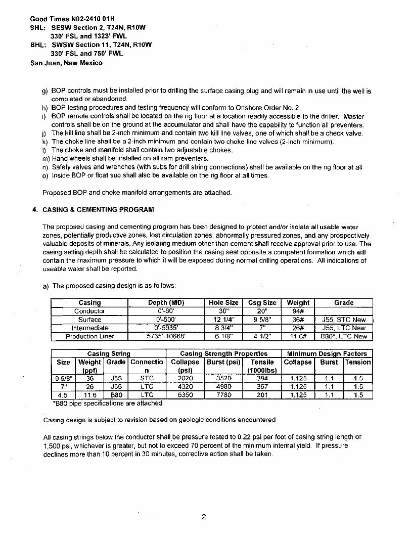
4. CASING & CEMENTING PROGRAM
The proposed casing and cementing program has been designed to protect and/or isolate all usable water zones, potentially productive zones, lost circulation zones, abnormally pressured zones, and any prospectively valuable deposits of minerals. Any isolating medium other than cement shall receive approval prior to use. The casing setting depth shall be calculated to position the casing seat opposite a competent formation which will contain the maximum pressure to which it will be exposed during normal drilling operations. All indications of useable water shall be reported.
a) The proposed casing design is as follows:
Casing Depth (MD) Hole Size Csg Size Weight Grade Conductor o'-eo* 30" 20" 94#
Surface 0-500' 12 1/4" 9 5/8" 36# J55, STC New Intermediate 0-5935' 8 3/4" 7" 26# J55, LTC New
Production Liner 5735'-10668' 6 1/8" 4 1/2" 11.6# B80*, LTC New
Casing Strini •1 Casing Strength Properties Minimum Design Factors Size Weight
(ppf) Grade Connectio
n Collapse
(psi) Burst (psi) Tensile
dOOOIbs) Collapse Burst Tension
9 5/8" 36 J55 STC 2020 3520 394 1.125 1.1 1.5 7" 26 J55 LTC 4320 4980 367 1.125 1.1 1.5
4.5" 11.6 B80 LTC 6350 7780 201 1.125 1.1 1.5 *B80 pipe specifications are attached
Casing design is. subject to revision based on geologic conditions encountered
All casing strings below the conductor shall,be pressure tested to 0.22 psi per foot of casing string length or 1,500 psi, whichever is greater, but not to exceed 70 percent of the minimum internal yield. If pressure declines more than 10 percent in 30 minutes, corrective action shall be taken.
2

Good Times NO 2-2410 01H SHL: SESW Section 2, T24N, R1OW
330' FSL and 1323' FWL BHL: SWSW Section 11, T24N, R10W
330' FSL and 750" FWL San Juan, New Mexico
b) The proposed cementing program is as follows
Casing Depth (MD)
Cement Volume (sacks)
Cement Type & Yield Designed TOC
Centralizers
Conductor 0'-60' 100 sks Type I Neat 16 ppq Surface None Surface 0-500' 314 sks HALCEM ™ SYSTEM +
2% CaCI2 +• 0.125lbm/sk Poly-E-
Flake. 15.8 ppg, 1.174 cuft/sk
Surface 1 per joint on bottom 3 joints
Intermediate 0-5935' 30% open hole excess Stage 1 Lead:
366 sks Stage 1 Tail:
404 sks Stage 2 Lead:
182 sks
Stage 1 Lead: HALCEM ™ SYSTEM + 0.2% HR-5 + 5lbm/sk Kol-Seal + 0.125lbm/sk Poly-E-
Flake. 12.3 ppg, 1.948 cuft/sk
Stage 1 Tail: VARICEM ™ CEMENT + .15%
CFR-3 + 5lbm/sk Kol-Seal + 0.125% Poly-E-Flake. 13.5 ppg, 1.308
cuft/sk. Stage 2 Contingency:
HALCEM ™ SYSTEM + 5lbm/sk Kol-Seal +
0.125lbm/sk Poly-E-Flake. 12.3 ppg,
Surface 1 every 3 joints through water bearing zones
Production 5735'- None - External Casing N/A N/A N/A Liner 10668' Packers
*Production liner clarification: Utilizing external swell casing packer system for zonal isolation will not use cement in the production liner
Actual volumes will be calculated and determined by conditions onsite. All cement slurries will meet or exceed minimum BLM and New Mexico Oil Conservation Division requirements. Slurries used will be the slurries listed above or equivalent slurries depending on service provider selected. Cement yields may change depending on slurries selected
All waiting on cement times shall be a minimum of 8 hours or adequate to achieve minimum of 500 psi compressive strength at the casing shoe prior to drilling out.
5. WELL PLAN & DIRECTIONAL DRILLING PROGRAM
The proposed horizontal well will have a kick off point of 4743'. Directional plans are attached.
Description Proposed Depth (TVD/MD) Formation Horizontal Lateral TD 5350710668' Gallup
3

Good Times N02-2410 01H SHL: SESW Section 2, T24N, R10W
330' FSL and 1323' FWL BHL: SWSW Section 11, T24N, R10W
330' FSL and 750' FWL San Juan, New Mexico
6. DRILLING FLUIDS PROGRAM
a) Surface through Intermediate Casing Point:
Holie Size (in) Depth (TVD/MD) Mud Type Density (ppg)
Viscosity (sec/qt) Fluid Loss (cc)
30" 0-60760' Fresh Water 8.3-9.2 38-100 4-28 12 1/4" 0'-50O750O' Fresh Water 8.3-10 60-70 NC 8 3/4" 5007500-542875935 FreshWater LSND 8.3-10 40-50 8-10
b) Intermediate Casing Point to TD:
Holie Size (in) Depth (TVD/MD) Mud Type Density
(ppg)
Viscosity (sec/qt) Fluid Loss (cc)
6 1/8" 542875935-5350710668' Fresh Water LSND 8.3-10 15-25 <15
c) There will be sufficient mud on location to control a blowout should one occur. Mud flow and volume will be monitored both visually and with electronic pit volume totalizers. Mud tests shall be performed every 24 hours after mudding up to determine, as applicable: density, viscosity, gel strength, filtration, and pH.
d) A closed-loop system will be used to recover drilling fluid and dry cuttings in both phases of the well and on all hole intervals. Above-ground tanks will be utilized to hold cuttings and fluids for rig operations. A frac tank will be on location to store fresh water. Waste will be disposed of properly at an EPA-approved hazardous waste facility. Fresh water cuttings will be disposed of at Basin Disposal, Inc. and/or Industrial Ecosystems, Inc. The location will be lined in accordance with the Surface Use Plan of Operations.
7. TESTING, CORING, & LOGGING
a) Drill Stem Testing - None anticipated. b) Coring - None anticipated. c) Mudd Logging - Mud loggers will be on location from kick off point to TD. d) Logging - See below
Cased Hole: CBL/CCL/GR/VDL will be run as needed for perforating control
8. ABNORMAL PRESSURES & HYDROGEN SULFIDE
The anticipated bottom hole pressure is +/- 2547 psi based on a 9.0 ppg at 5442' TVD of the horizontal lateral target, No abnormal pressure or temperatures are anticipated.
No hydrogen sulfide gas is anticipated, however, if H2S is encountered, the guidelines in Onshore Order No. 6
will be followed.
4
Good Times N02-2410 01H SHL: SESW Section 2, T24N, R10W
330' FSL and 1323" FWL BHL: SWSW Section 11, T24N, R10W
330' FSL and 750r FWL San Juan, New Mexico
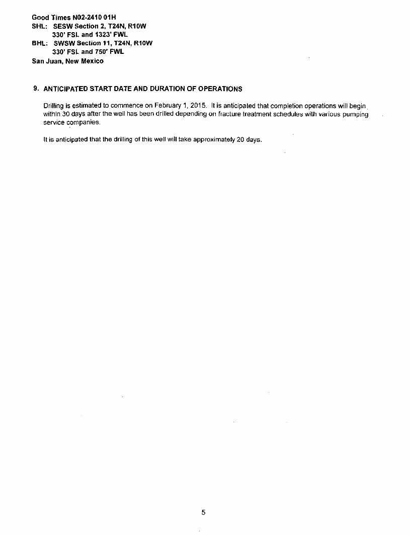
9. ANTICIPATED START DATE AND DURATION OF OPERATIONS
Drilling is estimated to commence on February 1, 2015. It is anticipated that completion operations will begin within 30 days after the well has been drilled depending on fracture treatment schedules with various pumping service companies.
It is anticipated that the drilling of this well will take approximately 20 days.
5

u o c : K W / 4 N W / 4 S e c 1 1 2 4 N 1 0 W 3 3 0 ' F N Encana Natural Gas ENQ: M ichae l Sane 6/3/14 county: San Juan WELL: Good Times N02-2410 01H WELL SUMMARY
R I 3 : A U K S S D
O L E : 6865
ftKBE: 6681
MWD OPCN HOLE OEPTM MOLC CASINO MW DEVIATION
LWD LOOGINQ FORM TVO MO SIZE SPECS MUD TYPE INFORMATION
60 30 20" 94*
lOOsx Type 1 Neat IS.Oppg cmt Frash w t i
8.3-8.2
Mult i -Wal l pad
- taktt survey ovary a l and
e n d run a n t l -
c o l l i * l o r
r c p o t l p r io r t o
spud
None
Nacimiento
9 S/S" Csg
0
500 500.00
12 1/4
8 5/8" 36ppf JS5 STC
TOC Surface wflh 100% OH Excess:
314 sks of HALCEM ™ SYSTEM * 2%
CaCI2 «• 0 .125 lbm/sk Poty -E-F lake .
M i x e d nl 15 8 p p g Y ie ld 1.174 cu f l /sk ,
Fresh w t r
6 3-10
Vertical
•=1°
N o OH logs
Ojo Alamo Ss
Kirtland Sftalo
Fruittand Coal
840
694
1.329
7"26ppl J55LTC Fresh Wt r
Survey Every
COM 20",
upcUtlri-g
Bnt lcoi l is lon
report aftor
surveys. S t o p
opera t ion*
and contact
d H U I n 9
engineer If
separat ion
factor
app foache*
1.S
Pictured Cliffs Ss,
Lewis Sha l t
Cliffhouso Ss .
Menefee Fn.
Point Lookaul Ss .
Mancos Shate
1.702
1.830
2.501
3.231
4.183
4.364
Stage tad© - 1.SS0 8 3/4 T O C dp sur face
3 0 % O H excess : 770 sksTo ta l .
If necessary , S la r j e 2 T o t a l : 182sks
Stage 1 L e a f : 3 6 6 sks H A L C E M ~
S Y S T E M • 0 . 2 % H R . S + SOmVsk Kf»P
See l • 0 .125tbm/sk P o t y £ - F 1 a k e . M i x e d
at 12 .3 p p g . Y ie ld 1.948 cu f t /sk .
8 > 1 0
Vertical
< V Survey Every
COM 20",
upcUtlri-g
Bnt lcoi l is lon
report aftor
surveys. S t o p
opera t ion*
and contact
d H U I n 9
engineer If
separat ion
factor
app foache*
1.S
Mud loggei
onsite
KOP 4,743 4,743
Stage 1 Tal l : 4 0 4 sks V A R I C E M * "
C E M E N T • . 1 5 % C F R . 3 • 5 lbm/sk K o l .
Sea l * 0 . 1 2 5 % P o l y - E - F l a k e . M ixed at
13.5 ppg. Y ie ld 1,308 ourVsk,
Surveys ovory
30' t h r o u g h
the curve
Mancos Sift
Gallup Fn.
r c»o
4.929
5.197
5,428 5.W5'
S tage 2 : 1 8 2 sks H A L C E M ™ S Y S T E M
• Slbmfsk Kol -Seal • 0 .12Slbm/sk Po ly -
E-F lake . M i x e d at 12 .3 ppg . Y ie ld 1.046
cu l l / sk .
Surveys avory
stand t o TO
un less
diroctc-d
o therw ise by
Geolog is t
Ho r t zon l * Ta igv l 3 * 4 2
61/8 20f f overta p at kner top
Horz Inc/TVD
Oldeg/54421. Surveys avory
stand t o TO
un less
diroctc-d
o therw ise by
Geolog is t
TD 5,350 10,648 m x DrCcd Lateral TD o 10668.2 MD
Surveys avory
stand t o TO
un less
diroctc-d
o therw ise by
Geolog is t
t+u OH Luy* Oo ic OoBup
41/2"11.6ppf SB80LTC W B M
8.3-10
MWO
Gamma
f l i rwt innf l l
Running tudarnal t *a f feb la cag packers fo«
feoWjon or prod «iu>9
Plan on set tng top packer within 100' of
n ie imed ia ts casing shoe
NOTES: 1) Drill with 30" bit to 6ff, set 20" 94# conductor pipe 2) Drill surface to 500'. RSC 0 5/8" cosing 3) N/U BOP and surface equipment 4) Drill to KOP of 4743'. 8 3/4 inch holesize bj HU directional tools and Stan curve at loaeg/TOO" Dulia rate 6) Drill to csg point of 5935' MD 7) R&C 7" csg. circ cmt lo surface, switch to WBM 8) Land at 90 deg, drill lateral to 10868' run 4 1/2 inch liner with external swetlable csg packers

CASING (OR) TUBING DESCRIPTION AND PERFORMANCE PROPERTIES
Pipe Outside Diameter (ins) 4.500 Pipe Wall Thickness (ins) 0.250 Nominal Weight Per Foot (lbs) 11.60
Thread Name Long Thread CSG Grade Name SB-80
Pipe Minimum Yield (psi) 80,000 Pipe Minimum Ultimate (psi) 90,000
Coupling Minimum Yield (psi) 80,000 Coupling Minimum Ultimate (psi) 100,000
Coupling or Joint Outside Diameter (ins) 5.000 Drift Diameter (ins) 3.875 Plain End Weight per Foot (lbs) 11.36
Joint Strength (lbs) 201,000 Internal Yield (psi) 7,780 Collapse Rating (psi) 6,350
MAXIMUM DEPTH/LENGTH BASED ON MUD WTS & SAFETY FACTORS
Drilling Mud Weight (ppg) 9.625
Tension Safety Factor 1.80 Maximum Tension Length (ft) 9,630
Internal Yield Safety Factor 1.10 Maximum Depth for Internal Yield (ft) 14,150
Collapse Safety Factor 1.125 Maximum Collapse Depth (ft) 11,290
API RELATED VALUES and INTERMEDIATE CALCULATION RESULTS
Coupling Thread Fracture Strength 464,000 Pipe Thread Fracture Strength (lbs) 201.000
Pipe Body Plain End Yield (lbs) 267,000 Round Thread Pull-Out (lbs) 219,000
Minimum Make-up Torque (ft-lbs) 1,640 Nominal Make-up Torque (ft-lbs) 2,190 Maximum Make-up Torque (ft-lbs) 2,740
Coupling Internal Yield (psi) 10,660 Pipe Body Internal Yield (psi) 7,780 Leak @ E1 or E7 plane (psi) 17,920
Pipe Hydrostatic Test Pressure @ 80 % SMYS 7,100

encana. natural gas
Project: San Juan County, NM Site; S2-T24N-R10W Well: Good Times N02-2410 01H
Wellbore: Hz Design: Plan #1
CATHEDRAL
-2000-
-1500-
-1000-
SECTION DETAILS
M D 0.0
4743.0 3338.8 6030.8
Inc Azi 0.00 O.OO 0.00 0.00
39.30 244.93 91.00 179.90
TVD 0.0
4743.0 3237.1 5430.5
+E/-W 0.0 0.0
-23S.2 -564.3
Dleg 0.00 O.OO
10.00 10.00
TFace 0.00 0.00
244.95 •75.84
VSoct 0.0 0.0
119.3 658.3
Target
GTN02-241001HPOE 10668.2 91.00 179.90 5349.6 -5295.9 -556.5 0.00 0.00 5294.9 GT N02-241001H PBHL
-500-
5 0 0 -
1000-
-OjoAramo Ssr ' i
- KMiand Slaw—-
-Ffurttend Coal-
- Pictured aits Ssr " -Lewis Shale "
2500— ̂ =c«mouse ssr—: : —
Menefee Fn. '
3500-
4000-
0 -
- 1 0 0 0 -
Storl bulld/lum @ 533B' MO «k KC"! ® t 7 > i
-200O
£ . -3000-
-4000-
-5000-
•«'i750>*
<-f75p|_ _ ^ % l_0
S1I-T24N.RIOW
UP @043O'TVD: 9V
GT N02-2410 01H PpHL
Surface Hole Location Good Times N02-2410 01H
Lat : 36 336706 Long : -107.870124
TARGET LINE
5442' TVD @ O VS: 9 1 '
I I I I I I I I I I I I I I I I I I I I I I I I I I I I I I I I I I I I I I I I I I I I I I I I I I I ' I I I I I I I I I I I I I I I I I I
- 1 0 0 0 0 1UUU 2 0 0 0 3 0 0 0 4 0 0 0 5 0 0 0 6 0 0 0
West(-)/East(+) (1500 ft/in)
'Point Lookout SS7 ' I
- Mancos ShaJe - ~
4500-_ KOP f_ 4743|_
5 0 0 0 -Mancos s i s * "
- — Gaiup Fn.
5 5 0 0 —
6000-
S500-
Slart buiU/tum ® 5338' MO
7- ICP © 230-; 85*
Magnetic Field Strength: 50205.4snT
Dip Angle: 63.03* Date: 4/17/2014
Model. IGRF2O10
TTII I I I 11111111 11
-500 0
DESIGN TARGET DETAILS
Name OTN02.24tO OIMPBHL GTNO2-24I0 OIHPOE
• 5295 9 •859.3
»E/ W •556,5 •5B4.3
Northing 1936571.99 1 CM 1208 62
2711702.B5 2711696.75
36.322158 36.334695
Lony iludo 107.872013
•107.872040
LP IB 5430' TVO: St •
Plan #1 Good Times N02-2410 01H
I4xxx; LR WELL @ 6881.0ft (Original Well Elev)
Ground Elevation ® 6865.0 Nut t l i A f f iK i i can D a t u m 1983
Well Good Times N02-2410 OIH.True North
T T
CASING DETAILS
TVD M D 500.0 500.0 5427.8 5935.0
Name 9 5/8"
7" ICP @ 2307 85"
-GTN02-2410 01HPBHL "
FORMATION TOP DETAILS
TVDPath MDPath Formation 840.0 840.0 Cjo Alamo Ss. 994.0 994.0 KjrUand Shale
1329.0 1329.0 Fruitlarxl Cod -1702.0 1702.0 Pictured Cliffs Ss. 1830.0 1830.0 Lewis Shale 2501.0 2501.0 Cliffhouse Ss. 3231.0 3231.0 Mervoloo Fn. 4183.0 4183.0 Point Lookout Ss. 4364.0 4364.0 Mancos Shale 4928.8 4932.2 Marcos Silt 5195.4 5264.4 Gallup Fn.
111111111111 I I I 11111111111111II11111111111 f 111111111111111 111
500 1000 1500 2000 2500 3000 3500
Vertical Section at 179.90" (1000 ft/in)
11111 j 111
4 0 0 0 4 5 0 0
TTT| I I I I I
5000 1111 j rrrrnTn
5500 6000

Planning Report
1
Database: , USA EDM 5000 Multi Users OB Local Co-ordinate Reference: Well Good Times N02-2410 01H
Company: { Encana Oil & Gas (USA) Inc TVD Reference: I WELL @ 6881 .Oft (Original Well Elev)
Project: San Juan County, NM MD Reference: WELL @ 6881 .Oft (Original Well Bev )
Site: ! 32-T24N-R10W : North Reference: True
Well : Good Times N02-2410 01H Survey Calculation Method: Minimum Curvature
Wcl lboro: Hz
Design: ; Plan #1
Project San Juan County, NM
Map System: US State Plane 1983 System Datum: Mean Sea Level
Geo Datum: North American Datum 1983
Map Zone: New Mexico Western Zone
Site S2-T24N-R10W
Site Posit ion: Nor th ing: 1,041,367.65 ft Latitude: 38.336706
From: Lat/Long East ing: 2,712,261.32 f t Longitude: -107.870124
Posit ion Uncertainty: 0.0 ft Slot Radius: 13.200m Grid Convergence: -0.02 °
Well Good Times NOZ-2410 01M
Well Posit ion +K7-S 0.0 ft North ing: 1,941,867.65 f t Latitude: 36.336706
+E/-W 0.0 ft East ing: 2,712,281.32 f t Longi tude: -107.870124
Posit ion Uncertainty 0.0 ft Wellhead Elevat ion: f t Ground Level: 6,865.0 f t
Wellborn Hz • .': . .. .. - -.- 1
Magnetics Model Name Sample Date Declination
O Dip Angle
n Field Strength
(nT)
IGRF2O10 4/17/2014 9.55 63.03 50.205
Design Plan#1
Audit Notes:
Version: Phase: PLAN Tie On Depth: 0.0
Vertical Section: - Depth From (TVD> +N/-S +F7-W Direct ion
(ft) (ft) («) n n n 0.0 0.0 179.90
Plan Sections
Measured Vertical Dogleg Bui ld Turn
Depth Inclination Azimuth Depth +N/-S +E/-VW Rate Rate Rate TFO
(ft) n n (ft) («) (ft) (°/100ft) 7100ft) C/lCOft) O Target
o.o 0.00 O.OO 0.0 0.0 0.0 0.00 0.00 0.00 0.00
4,743.0 0.00 0 00 4,743.0 0.0 0 0 n.no 0.00 o o n 0 00
5.338.8 59.56 244.95 5,237.1 -119.7 -256.2 10.00 10.00 0.00 244.95
6.030.& 91.00 179.90 5,430.5 -659.3 -564.3 10.00 4.54 - 9 4 0 -75.84 GTN02-2410 01HPC
10,668.2 91.00 179.90 5,349.6 -5.295.9 -556.5 0.00 0.00 0.00 0.00 GTN02-2410 01HPE
4/24/2014 11:04:59AM Page 1 COMPASS 5000.1 Build 62

Planning Report
Database: USA EDM 5000 Multi Users OB Local Co-ordinate Reference: Well Good Times N02-2410 01H
Company: EnCana Oil & Gas (USA) Inc TVD Reference: , W E L L ® 6881.OH (Original Well Elev)
Project: San Juan County, NM MD Reference: WELL @ 6881 .Oft (Original Wen Elev)
Site: S2-T24N-R10W North Referonco: True
Well : Good Times N02-2410 01H Survey Calculation Method: Minimum Curvature
Wellbore: : Hz
Design: Plan #1
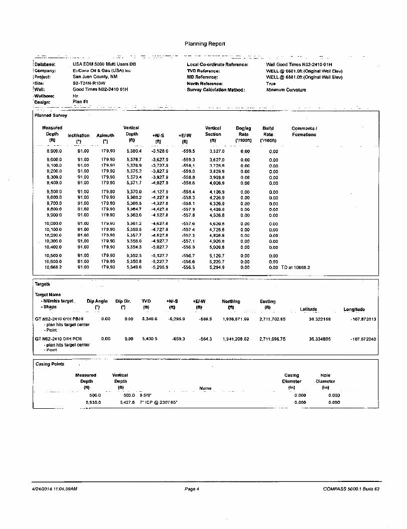
Planned Survey
Measured Vertical Vertical Dogleg Bui ld Comments / Depth Incl ination Azimuth Depth +N/-S +EMW Sect ion Rate Rate Formations
(ft) H n (ft) (ft) (ftl (ft) p iOUf t ) (710 OR)
o.o 0.00 0.00 0.0 0.0 0.0 0.0 0.00 0.00 100.0 0.00 0.00 1O0.0 0.0 0.0 0.0 0.00 0.00
200.0 0.00 0.00 200.0 0.0 0.0 0.0 o.oo 0.00 300.0 0.00 0.00 300.0 0.0 0.0 0.0 0.00 0.00
400.0 0.00 0.00 400.0 0.0 0.0 0.0 0.00 0.00
500.0 0.00 0.00 500.0 0.0 0.0 0.0 0.00 0.00 9 5/8"
600.0 0.00 0.00 600.0 0.0 0.0 0.0 0.00 0.00
700.0 0.00 0.00 700.0 0.0 0.0 0.0 0.00 0.00
800.0 0.00 0.00 800.0 0.0 0.0 0.0 0.00 0.00
840.0 000 0.00 840.0 0.0 0.0 0.0 0.00 0.00 Ojo Alamo Ss.
900.0 0.00 0.00 900.0 0.0 0.0 0.0 0.00 0.00 994.0 0.00 0.00 994 0 0.0 0.0 0.0 0.00 0.00 Kirrlanri Shale
1,000.0 0.00 0.00 1,000.0 oo 0.0 0.0 0.00 0.00
1,100.0 0.00 0.00 1,100.0 0.0 0.0 0.0 o.oo 0.00 1,200.0 0.00 0.00 1,200.0 0.0 0.0 0.0 o.oo 0.00
1.300.0 0.00 0.00 1,300.0 0.0 0.0 0.0 0.00 0.00 1,329.0 0.00 0.00 1,329.0 0.0 0.0 0.0 0.00 0.00 Fruitland Coal
1,400.0 0.00 0.00 1,400.0 0.0 0.0 0.0 0.00 0.00 1,500.0 0.00 0.00 1.500.0 0.0 0.0 0.0 0.00 0.00
1,600.0 0.00 0.00 1,600.0 0.0 0.0 0.0 0.00 0.00
1,700.0 0.00 0.00 1,700.0 0.0 0.0 0.0 0.00 0.00
1,702.0 0.00 0.00 1,702.0 0.0 0.0 0.0 0.00 0.00 Pictured Cliffs Ss.
1,800.0 0.00 0.00 1,800.0 0.0 0.0 0.0 0.00 0.00
1,830.0 0.00 0.00 1.830.0 0.0 0.0 0.0 0.00 0.00 Lewis Shale
1,900.0 0.00 0.00 1,900.0 0.0 0.0 0.0 0.00 0.00
2,000.0 0.00 0.00 2,000.0 0.0 0.0 0.0 0.00 o.oo 2,100.0 0.00 0.00 2.100.0 0.0 0.0 0.0 0.00 0.00
2,200.0 0.00 0.00 2,200.0 0.0 0.0 0.0 0.00 0.00
2,300.0 0.00 0.00 2,300.0 0.0 0.0 0.0 0.00 0.00
2,400.0 0.00 0.00 2,400.0 0.0 0.0 0.0 0.00 0.00
2,500.0 0.00 0.00 2,500.0 0.0 0.0 0.0 0.00 0.00
2.501.0 0.00 0.00 2,501.0 0.0 0.0 0.0 0.00 0.00 Cliffhouse Ss.
2,600.0 0.00 0.00 2,600.0 0.0 0.0 0.0 0.00 0.00 2,700.0 0.00 0.00 2,700.0 0.0 0.0 0.0 o.oo 0.00
2,800.0 0.00 0.00 2,800.0 0.0 0.0 0.0 0.00 0.00
2,900.0 0.00 0.00 2,900.0 0.0 0.0 0.0 o.oo 0.00
3,000.0 0.00 0.00 3,000.0 0.0 0.0 0.0 0.00 0.00
3,100.0 0.00 0.00 3,100.0 0.0 0.0 0.0 0.00 0.00
3,200.0 0.00 0.00 3,200.0 0.0 0.0 0.0 0.00 0.00
3,231.0 0.00 0.00 3,231.0 0.0 0.0 0.0 0.00 0.00 Menefee Fn.
3.300.0 0.00 0.00 3,300.0 0.0 0.0 0.0 0.00 0.00
3,400.0 0.00 0.00 3.400.0 0.0 0.0 0.0 0.00 0.00
3,500.0 0.00 0.00 3,500.0 0.0 0.0 0.0 0.00 0.00
3,600.0 0.00 0.00 3.600.0 0.0 0.0 0.0 0.00 0.00
3,700.0 0.00 0.00 3,700.0 0.0 0.0 0.0 0.00 0.00
3,800.0 0.00 0.00 3,800.0 0.0 0.0 0.0 0.00 0.00
3,900.0 0.00 0.00 3,900.0 0.0 0.0 0.0 0.00 0.00
4.000.0 0.00 0.00 4,000.0 0.0 0.0 0.0 0.00 0.00
4,100.0 0.00 0.00 4,100.0 0.0 0.0 0.0 0.00 0.00
4.183.0 0.00 0.00 4,183.0 0.0 0.0 0.0 0.00 0.00 Point Lookout Ss
4.200.0 0.00 0.00 4,2:00.0 0.0 0.0 0.0 0.00 0.00
4.300.0 0.00 0.00 4.300.0 0.0 0.0 0.0 0.00 0.00
4/24/2014 11:04:59AM Page 2 COMPASS 5000.1 Build 62

Planning Report
Database: USA EDM 5000 Multi Users DB Local Co-ordinate Reference: Well Good Times N02-241001H
] Company: EnCana Oil & Gas (USA) liw TVD Reference: WELL @ 6801 .Oft (Original Wtoll Elev)
I Project: San Juan County, NM MD Reference: WELL @ 6881.0ft (Original Well Elev)
|Sito: S2-T24N-R10W North Roforonco: True
| Well: Good Times N02-2410 01H Survey Calculation Method: Minimum Curvature
! Wellbore: Hz
i Design: Plan #1
Planned Survey
Measured Vertical Vertical Dogleg Bui ld Depth Inclination Azimuth Depth +N/-B +E/-W Section Rate Rate
I") n n (ft) (ft) (ft) (ft) (•/100ft) (•/100ft)
4.364.0 0.00 0.00 4.364.0 0.0 0.0 0.0 0.00 0.00 4,400.0 0.00 0.00 4.400.0 0.0 0.0 0.0 0.00 0.00 4.500.0 0.00 0.00 4,500.0 0.0 0.0 0.0 0.00 0.00
4,600.0 0.00 0.00 4.600.0 0.0 0.0 0.0 0.00 0.00 4,700.0 0.00 0.00 4,700.0 0.0 0.0 0.0 0.00 0.00 4,743.0 0.00 0.00 4,743.0 0.0 0.0 0.0 0.00 0.00 4,800.0 5.70 244.95 4,799.9 -1.2 -2.6 1.2 10.00 10.00 4,900.0 15.70 244.95 4,090.0 -9.0 -19.4 9.0 10.00 10.00
4,932.2 18.91 244.95 4,926.8 -13.1 -28.0 13.1 10.00 10.00 5,000.0 25.69 244.95 4,991.5 -24.0 -51.3 23.9 10.00 10.00 5,100.0 35.69 244.95 5,077.4 -45.6 -97.5 45.4 10.00 10.00 5.200.0 4 5 6 9 244.95 S.1S3.1 -73.1 -ISfi.S 72.9 10.00 moo 5,264.4 52.12 244.95 5,195.4 -93.7 -200.4 93.3 10.00 10.00
5,300.0 55 68 244.95 5,216.4 -105.8 -226.6 105.4 10.00 10.00 5,338.8 59.56 244.95 5,237.1 -119.7 -256.2 119.3 10.00 10.00 5,400.0 61.24 238.18 5,267.4 -145.0 -302.9 144.5 10.00 2.73 5,500.0 64.65 227.62 5,313.0 -198.7 -373.7 198.1 10.00 3.42 5,600.0 68.78 217.70 5.352.6 -266.3 -435.8 265.5 10.00 4.13
5,700.0 73.45 208.34 5.385.0 -345.5 -487.2 344.7 10.00 4.67 5,800.0 78.52 199.45 5.409.3 -434.1 -526.3 433.2 10.00 5.07 5,900.0 83.85 190.88 5,424.6 -529.4 -552.1 528.4 10.00 5.33 5,935.0 85.75 187.93 5.427.6 -563.8 -557.8 562.8 10.00 5.43 6,000.0 89.31 182.48 5,430.6 -628.4 -563.7 627.4 10.00 5.47
6.030.8 91.00 179.90 5,430.5 -659.3 -564.3 658.3 10.00 5.49 0,100.0 91.00 170.00 5,429.3 -728.4 -564.2 727.4 0.00 0.00 6,200.0 91.00 179.90 5,427.5 -828.4 -564.0 827.4 0.00 0.00 6.300.0 91.00 179.90 5,425.8 -928.4 -563.9 927.4 0.00 0.00 6,400.0 91.00 179.90 5,424.1 -1,028.3 -563.7 1,027,4 0.00 0.00
6.500.0 91 00 179.90 5.422.3 -1.128.3 -563.5 1,127.3 0.00 0.00 6,600.0 91.00 179.90 5,420.6 -1,228.3 -563.4 1,227.3 0.00 0.00 6,700.0 91.00 179.90 5,418.8 -1,328.3 -563.2 1,327.3 0.00 0.00 6,800.0 91.00 179.90 5,417.1 -1,428.3 -563.0 1,427.3 0.00 0.00 6,900.0 91.00 179.90 5.415.3 -1.528.3 -562.9 1,527.3 0.00 0.00
7,000.0 91.00 179.90 5,413.6 -1,628.3 -562.7 1,627.3 0.00 0.00
7,100.0 91.00 179.90 5,411.8 -1.728.2 -562.5 1,727.3 0.00 0.00 7,200.0 31.00 179.90 3,410.1 -t,8Z6.2 -962.3 t.827.2 0.00 0.00
7,300.0 91.00 179.90 5.408.4 -1.928.2 -562.2 1,927.2 0.00 0.00 7,400.0 9 i .no 179,90 5,406.6 -2.028.2 -562 0 2.027.2 0.00 0.00
7,500.0 91.00 179.90 5,404.9 -2.128.2 -561.8 2,127.2 0.00 0.00 7,600.0 91.00 179.90 5.403.1 -2.228.2 -561.7 2,227.2 0.00 0.00
7,700.0 91.00 179.90 5,401.4 -2,328.1 -561.5 2.327.2 0.00 o.oo 7,800.0 91.00 179.90 5,399.6 -2,428.1 -561.3 2,427.1 0.00 0.00
7,900.0 91.00 179.90 5,397.9 -2,528.1 -561.2 2,527.1 0.00 0.00
8.000.0 91.00 179.90 5,396.1 -2,628.1 -561.0 2,627.1 0.00 0.00 8,100.0 91.00 179.90 5,394.4 -2,728.1 -5S0.8 2,727.1 0.00 0.00
8,200.0 91.00 179.90 5,392.6 -2,828.1 -560.6 2.827.1 0.00 0.00 8.300.0 91.00 179.90 5.3SU.9 -2,928.1 -560.5 2,927.1 0.00 0.00
8,400.0 91.00 179.90 5,389.2 -3,028.0 -560.3 3,027.1 0.00 0.00
8,500.0 91.00 179.90 5,387.4 -3,128.0 -560.1 3,127.0 0.00 0.00
8.600.0 91.00 179.90 5,385.7 -3,228.0 -560.0 3,227.0 0.00 0.00
0,700.0 91.00 170.00 5,383.0 -3,328.0 -559.8 3.327.0 0.00 0.00
8,800.0 91.00 179.90 5,382.2 -3,428.0 -559.6 3,427.0 0.00 0.00
Comments /
Formations
Mancos Shale
Mancos Silt
Gallup Fn.
Start build/turn @ 5338' MD
7" ICP @ 2307 85°
LP @ 5430' TVD; 91"
4/24/2014 11:04:59AM Page 3 COMPASS 5000.1 Build 62
PJanning Report
! Database:
) Company:
'Project:
•Site: jwell: Iwellbore:
Design:
USA EDM 5000 Multi Users DB
EnCsna Oil & Gas (USA) Inc
San Juan County, NM
S2-T24N-R10W
Good Times N02-2410 01H
Hz
Plan #1
Local Co-ordinate Reference:
TVD Reference:
MD Reference:
. North Reference:
Survey Calculation Method:
Well Good Times N02-2410 01H
WELL @ 0801 .Oft (Original Well Elev)
WELL® 6881 .Oft(Original Well Elev)
True
Minimum Curvature
Planned Survey
Measured Vertical Vertical Dogleg Bui ld Depth Inclination Az imuth Depth +N/-S +E/-W Section Rate Rate
(ft) n n (ft) («) (ft) (ft) (7100ft) (7100ft)
8.900.0 91,00 179.90 5.380.4 -3.528.0 -559.5 3,527.0 0.00 0.00
9.000.0 91.00 179.90 5,378.7 -3,627.9 -559.3 3,627.0 0.00 0.00 9,100.0 91.00 179.90 5.376.9 -3.727.9 -559.1 3.726.9 0.00 0.00 9,200.0 91.00 179.90 5.375.2 -3,827.9 -559.0 3,826.9 0.00 0.00 9.300.0 91.00 179.90 5.373.4 -3,927.9 -558.8 3,926.9 0.00 0.00 9,400.0 91.00 179.90 5.371.7 -4.027.9 -558.6 4,026.9 0.00 0.00
9,500.0 91.00 179.90 5,370.0 -4,127.9 -558.4 4,126.9 0.00 0.00 9,600.0 91.00 179.90 5,368.2 -4,227.9 -558.3 4,226.9 0.00 0.00 9,700.0 91.00 179.90 5,366.5 -4,327.8 -558.1 4,326.9 0.00 0.00 9,600.0 91.00 179.90 5,304.7 -4,427.8 -557.9 4,420.8 0.00 0.00 9.900.0 91.00 179.90 5,363.0 -4,527.8 -557.8 4,526.8 0.00 0.00
10,000.0 91.00 17y.90 5,361.2 -4,627.8 -557.6 4,626.8 0.00 0.00 10,100.0 91.00 179.90 5,359.5 -4,727.8 -557.4 4,726.8 0.00 0.00 10,200.0 91.00 179.90 5,357.7 -4,827.8 -557.3 4,826.8 0.00 0.00 10,300.0 91.00 179.90 5,356.0 -4,927.7 -557.1 4,926.8 0.00 0.00 10,400.0 91.00 179.90 5,354.3 -5,027.7 -556.9 5,026.8 0.00 0.00
10,500.0 91.00 179.90 5,352.5 -5,127.7 -556.7 5,126.7 o.oo 0.00 10.600.0 91.00 179.90 5,350.8 -5,227.7 -556.6 5,226.7 0.00 0.00 10,668.2 91.00 179.90 5,349.6 -5,295.9 -556.5 5,294.9 0.00 0.00
Comments/
Formations
TDat 10668.2
Targets
Target Name
- hit/miss target . D ip Angle
-Shape. (°)
Dip Dir.
n TVD
(ft)
+N/-S
(«» +E/-W
(ft)
Northing
(ft)
Easting
(ft) Latitude Longitude
GT N02-2410 01H PBH1 0.00 - plan hits target center - Point
0.00 5,349.6 -5,295.9 -656.5 1,936,671.99 2,711,702.85 36.322158 -107.872013
GTN02-2410 01HPOE 0.00
- plan hits target center - Point
0.00 5.430.5 -659.3 -564.3 1.941.208.62 2,711,696.75 36.334895 -107.872040
Casing Points
Measured Vertical Casing Hole
Depth Depth Diameter Diameter
(ft) (ft) Name (in) (in)
500.0 500.0 9 5/8" 0.000 0.000
9,935.0 5,427.8 7" ICP @ 2307 85" 0.000 0.000
4/24/2014 11:04:59AM Page 4 COMPASS 5000.1 Build 62

Planning Report
Database: USA EDM 5000 Multi Users DB Company: : EnCana 00 & Gas (USA) Inc Project San Juan County, NM Site: ! S2-T24N-R10W Well: | Good Times N02-2410 01H Wetlbore: Hz Design: Plan #1
Local Co-ordinate Reference: i TVD Reference: ! MD Reference: North Reference: Survey Calculation Method:
Well Good Times N02-2410 01H WELL® 6881.0ft(Original Well Elev) WELL® 6881.0ft(Original Well Elev) True Minimum Curvature
Formations
Measured Vertical Dip Depth Depth Dip Direction
(ft) (ft) Name Lithology C) n 840.0 840.0 Ojo Alamo Ss. -1.00 179.90 994.0 994.0 Kirtland Shale -1.00 179.90
1,329.0 1,329.0 Fruitland Coal -1.00 179.90 1,702.0 1,702.0 Pictured Cliffs Ss. -1.00 179.90 1,830.0 1,830.0 Lewis Shale -1.00 179.90 2,501.0 2,501.0 Cliffhouse Ss. -1.00 179.90 3,231.0 3,231.0 Menefee Fn. -1.00 179.90 4,183.0 4,183.0 Point Lookout Ss. -1.00 179.90 4,364.0 4,364.0 Mancos Shale -1.00 179.90 4,932.2 4,929.0 Mancos Silt -1.00 179.90 5,264.4 5,197.0 Gallup Fn. -1.00 179.90
Plan Annotations
Measured Vertical Local Coordinates Depth Depth +N/-S +E/-W
(ft) (ft) (ft) (ft) Comment
4,743.0 4.743.0 0.0 0.0 KOP @ 4743' 5,338.8 5.237.1 -119.7 -256.2 Start build/turn @ 5338' MD G.030.a 5,430.5 -650.3 -564.3 LP @ 5430' TVD; 91"
10,668.2 5,349.6 -5,295.9 -556.5 TD at 10668.2
4/24/2014 11:04:59AM Page 5 COMPASS 5000.1 Build 62

EnCana Oil & Gas (USA) Inc San Juan County, NM S2-T24N-R10W Good Times N02-2410 01H Hz Plan#1
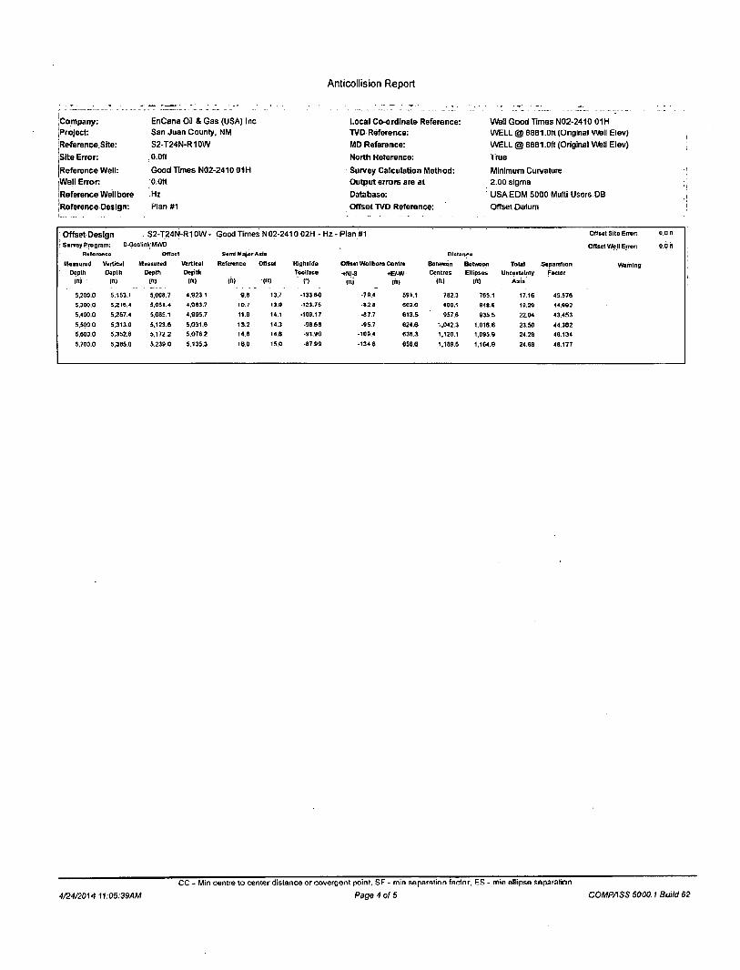
Anticollision Report
24 April, 2014

Anticollision Report
Company: | Project: iReferencs Site: Site Error: Reference Well: Well Error: Reference Wellbore ,Reference Design:
EnCana Oil & Gas (USA) Inc HSan Juan County, NM S2-T24N-R10W 0.0ft
Good Times N02-2410 01H O.Ufl
Hz
Plan »1
Local Coordinate Reference: < TVD Reference: ' MD Reference: • North Reference: , Survey Calculation Method: ' Output errors are at
Database: Offset TVD Reference:
Well Good Times N02-2410 01H ' WELL® 6881.0ft (Original Well Elev) WELL® 6881.0ft(Original Well Elev) True
Minimum Curvature ' 2.00 slgma
USA EDM 5000 Multi Users OB Offset Datum
Reference
Filter type: Interpolation Method: Depth Range: Results Limited by:
Plan«1
NO GLOBAL FILTER: Using user defined selection & filtering criteria MD Interval 100.0ft Error Model: Unlimited Scan Method: Maximum center-center distance of 1,243.2ft Error Surface:
Systematic Ellipse Closest Approach 3D Elliptical Conic
Warning; Levels Evaluated at: 2.00 Sigma
Survey Tool Program Date 4/24/2014
From To
! («) (ft) Survoy (Wellbore) Tool Name Descript ion
0.0 10,667.3 Plan #1 (Hz) Geolink MWD Geolink MWD
Summary
Reference Offset Distance Measured Measured Between Between Separation Warning
Site Name Depth Depth Centres Ell ipses Factor Offset Well - Wellbore - Design (ft) (ft) (ft) (ft)
S2-T24N-R10W
Good Times N02-2410 02H - Hz - Hlan #1 3.U00.U 3,000.0 30.2 19.7 2.895 CC, ES, SF
4/24/2014 11:05:39AM
CC - Min centre to center distance or ooverrjent point, SF - min Reparation factor. ES - min ellipse separation
Page 2 of 5 COMPASS 5000.1 Build 62

Anticollision Report
Company: Project:
'Reference Slto:
Site Error: i Reference Well: Well Error: Reference Wellbore Reference Design:
, EnCana Oil & Gas (USA) Inc San Juan County, NM S2-T24N-R10W 0.0ft
Good Times N02-241001H 0.0ft
Hz
Plan#1
Local Co-ordinate Reference: TVD Reference:
. MD Reference: North Reference: Survey Calculation Method: Output errors are at Database:
Offset TVD Reference:
Well Good Times N02-2410 01H WELL @ 6881.0ft (Original well Elev) WELL @ 6881.0ft (Original Well Elev)
. True Minimum Curvature 2.00 sigma
: USA EDM 5000 Multi Users DB Offset Datum
' Offset Design . S2-T24N-R10W- Good Times N02-2410 02H - Hz - Plan #1 O f f s e t S i t e E r r o r : 0 .0 f t
S u r v e y P r o g r a m : 0-Geo l ink M W D O f f a c t W e l l E r r o r 0 .6 It
R a r e i e n c e O f f s c t Scm l M a j o r A x l e D i s t a n c e
; Measu red Ver t i ca l M e a s u r e d V e r t i c a l Re fe rence O f f s e t H l j h i i o o Of fse t W e l l b o r e C e n t r e B e t w e e n B e t w e e n ' To ta l S e p a r a t i o n W a r n i n g
Dep th Dep t t i D e p t h D o p t h t b o l f a c e •INU-S C e n t r e s E l l i p ses u n c e r t a i n l y F a c t o r
< • tm ("1 :m ( f t ) (HI CO CI t i l l in) 1" ) ( n | Aa !>
0 .0 0.0 0 0 0.0 0 0 0.0 6 3 . 8 7 13.2 2 7 . 1 30.2
100.0 100.0 10O.0 100.0 0.1 0.1 S3.07 13.2 2 7 . 1 30.2 2 0 0 0.20 102 .847
200 .0 200.0 2 0 0 . 0 200 0 0.3 0.3 6 3 . 9 7 13.2 2 7 . 1 30.2 29 .5 0.64 4 8 9 5 2
300 .0 300.0 3 0 0 . 0 300.0 0 5 0.5 8 3 . 9 7 13 .2 2 7 . 1 30.2 2 9 . 2 0.99 3 0 . 4 2 0
400 .0 400.0 4 0 0 . 0 400.0 0 .7 0.7 63 .97 13 .2 2 7 . 1 30.2 28 .8 1.34 22 .498
500.0 500.0 5 0 0 . 0 500.0 0 .8 0.6 63 .97 13.2 2 7 . 1 30,2 28 .5 1.89 17 .650
800 .0 eoo.o 6 0 0 . 0 600.0 1.0 1.0 6 3 , 9 7 13.2 2 7 . 1 30 .2 2 8 . 1 2.04 14 .793
700.0 700.0 700 .0 700 .0 1 2 1.2 6 3 , 9 7 13.2 2 7 . 1 30.2 27 .8 2 .39 12 8.30
40O.O 000.0 000 0 0 0 0 . 0 1.4 1.4 6 3 . 3 7 43 .2 2 7 . 1 30 .2 27 ,4 2 7 4 11.010
9 0 0 . 0 900.0 900 .0 900 .0 1.5 1.5 6 3 . 9 7 13.2 2 7 . 1 30 .2 27 .1 3.09 9 .773
1.000.0 1,000.0 1,000.0 1 .000.0 1.7 1.7 6 3 . 9 7 53 .2 2 7 . 1 30 .2 26 .7 3.43 6 .780
1.100.0 1,100.0 1.100.0 1.100.0 1.9 1.9 6 3 . 9 7 13 .2 2 7 . 1 30 ,2 26 .4 3.78 7 .970
1.200.0 1.200.0 1.200.0 1.200.0 2 1 2.1 6 3 . 9 7 13 .2 2 7 . 1 30.2 2 6 . 0 4.13 7 .297
1,300.0 1.300.0 1.300.0 1 .300.0 2.2 2.2 6 3 . 9 7 13.2 2 7 . 1 30.2 2 5 . 7 4 .48 6 . 7 2 8
1,400.0 1.400.0 1.400 0 1.400.0 2.4 2.4 6 3 . 9 7 13.2 2 7 . 1 3 0 2 25 .3 4.83 6 . 2 4 2
1.SU0.0 1,900.0 1.300.0 1.300.0 2.0 2.0 0 3 , « 7 13 .2 27_1 30 .2 2 5 . 0 S.10 5 .322
1.600.0 1.600.0 1.600.0 1.600:0 2.6 2 .8 6 3 . 9 7 13 .2 2 7 . 1 30.2 24 .6 5.53 5 .454
1,700.0 1.700.0 1,700.0 1.700.0 2.9 2.9 6 3 . 9 7 13 .2 2 7 . 1 30.2 24 .3 3.8B 5 , 1 3 0
1,800.0 1.800 0 1.600.0 1.800.0 3.1 3.1 6 3 . 9 7 13 .2 2 7 . 1 30.2 23 .9 6.23 4 .843
I 900 0 1.800 0 1.90O.0 1.900.0 3.3 3.3 6 3 . 9 7 13 .2 2 7 . 1 30.2 23 .6 6.S6 4 . 5 6 6
2 ,000 .0 2.0OO.O 2 ,000 .0 2 .000 .0 3.5 3.5 6 3 . 9 7 13 .2 2 7 . 1 30.2 2 3 . 2 8 .93 4 .354
2 .100 .0 2 .100 0 2 , 1 0 0 . 0 2 .100 .0 3.S 3 « S3.H7 13 .2 2 7 . 1 3 0 2 2 2 9 7.27 4 . 1 4 5
2 .200 .0 2 ,200 .0 2 ,200 .0 2 . 2 0 0 . 0 3.8 3.8 6 3 . 9 7 13 2 2 7 . 1 30.2 22 .5 " 7 . 6 2 3 .956
2 ,300 .0 2 .300 .0 2 ,300 .0 2 . 3 0 0 . 0 4.0 4 .0 6 3 . 9 7 13 .2 2 7 . 1 30 2 2 2 2 7.97 3 .782
2 ,400 .0 2 .400.0 2 ,400 .0 2 . 4 0 0 . 0 4.2 4 .2 6 3 . 9 7 13 .2 2 7 . 1 30.2 21 .8 8.32 3.624
2,500 0 2 ,500 0 2 .500.0 2.5O0.O 4.3 4 .3 6 3 . 9 7 13 .2 27 .1 30 .2 21 .5 8.87 3 .478
2 ,600 .0 2 .600 .0 2 ,600 0 2 ,600 .0 4.5 4 .5 6 3 . 9 7 13 .2 27 .1 30 .2 21 .1 9,02 3 .343
2 .700 .0 2 .700.0 2 .700.0 2 .700 .0 4.7 4.7 6 3 . 9 7 13 .2 27 .1 30 .2 20 .8 9.37 3 .219
2 .000 .0 s.sao.o 2.900.0 2 ,800 .0 1 0 4.0 6 3 . 0 7 •13.2 27 .1 30.2 20 .4 9.72 3 .103
2 .900.0 2 .900.0 2 .900 .0 2 .900 .0 5 0 5.0 6 3 . 9 7 1 3 . 2 27 .1 30.2 20.1 10.07 2 .996
3.000-.0 3 .000.0 3 ,000 .0 3 .000 .0 5 2 5.2 6 3 . 9 7 13.2 2 7 . 1 3 0 2 19 .7 10 42 2 .895 C C , E S , SF
3 .100.0 3 .100.0 3,095 0 3 .094.6 5.4 5.4 7 1 . 0 5 1 2 . 0 3 4 . 9 37.2 26 .5 10.76 3 .451
3 .200.0 3 .200.0 3 .188.3 3 .183.0 5.6 5.6 8 1 . 5 5 8.4 5 6 . 6 59.6 48 .5 11.13 5 .359
3 ,300.0 3 .300.0 3 .281.7 3 .274.2 5.7 5.8 6 7 . 4 3 3.6 6 4 . 6 86.5 77 .0 11.55 7 . 6 6 4
3 ,400 .0 3 .400.0 3 .377.2 3 .365.4 5.9 6.1 90 .41 -0.8 112.6 117.8 10S.8 12.00 9 . 6 1 9
3 ,300.0 3 ,300.0 3 .472.7 3.450.5 0.1 0.4 02 .20 -5.4 140 .0 147.3 134.8 12.47 11.808
3.60O.0 3 ,600.0 3 .566.2 3 ,547.7 6 3 6 8 9 3 . 3 9 - 1 0 . 0 168 .6 176,8 163.8 12.97 13 .632
3 ,700.0 3 ,700.0 3 ,663.7 3 .63B.9 0.4 7. ) 94 .24 •14 .6 1WJ.O Z W . 4 11*2.9 13.49 1 3 . 3 0 3
3 ,800.0 3 .800.0 3 ,759 .1 1 ,730.0 6.6 7.5 9 4 . 6 8 - 1 9 . 2 2 2 4 , 6 236 .0 2 2 2 . 0 14.02 16 .831
3 .900.0 3 .900.0 3 , 8 5 4 6 3 ,821 .2 6.8 7.9 9 5 . 3 8 - 2 3 8 2 5 2 . 6 265.7 25« .1 14.57 18 .230
4 .000.0 4 .000 0 3 .950 .1 3 .912.4 7.0 8.4 9 5 . 7 8 -28 .4 2 8 0 . 6 295.4 2 6 0 2 15.14 19.511
4 ,100 .0 4 .100.0 4 . rU5 . f i 4 ,nn3 .5 7 1 8 6 9 6 . 1 0 . 3 3 0 308 6 325.0 3 0 9 3 15.71 2 0 . 6 8 6
4 .200 .0 4 ,200.0 4 ,141 .1 4..094.7 7.3 9,3 9 6 . 3 7 -37 .6 3 3 6 . 6 354.7 338.4 16.30 2 1 . 7 6 6
4 ,300 .0 4 .300.0 4 .23S.5 4 .185 8 7.5 9.7 9 6 . 6 0 - 4 2 2 3 8 4 . 6 364.4 367 .5 16.89 2 2 . 7 6 0
4 ,400 .0 4 .400 ,0 4 , 3 3 2 . 0 4 .277 .0 7.7 10,2 9 6 , 7 9 - 4 6 . 8 392 .7 414 .1 398 .6 U . 4 * 23 .B78
4 .500 .0 4 ,500 .0 4 . 4 2 7 5 4 .366 .2 7.6 10,7 9 8 . 9 6 -51 .4 420 .7 443.8 425 .7 18.10 24 5 2 6
4 .600 .0 4 . 6 0 0 0 4 .523 .0 4-.4S9.3 8.0 11.1 97 .11 •56 .0 4 4 8 . 7 473.5 454 .8 18.71 25 .311
4.70O.0 4 .700 .0 4 ,618 .5 4 ,550 .5 8.2 11.8 97 .24 •60 .8 4 7 8 . 7 503.2 483 .9 19.32 2 6 . 0 4 1
4 .800 .0 4 .700 .0 4 ,713 .2 D.640.0 6.4 12.1 - 146 .66 - 6 5 . 1 5 0 4 . 5 5 3 5 2 5 1 S 8 16 4 5 32 -142
4 ,900 .0 4 .898 .0 4 .902 .3 41.726.0 6.5 12.6 - i 4 4 . e e -60 .4 530 6 579.4 562.9 16.47 3 5 . 1 8 8
5 .000.0 4 .991 .5 4 .082.8 4 .602 .9 8 8 13.0 •142 .61 - 7 3 . 3 554 .2 6 3 6 2 6 1 9 8 18 38 3 8 . 0 3 4
5 ,100 0 5 .077.4 4 ,852 3 4 .669.3 9.2 13.4 - 1 3 9 . 2 2 -76 .8 574 6 704.3 6 8 7 . 8 16.45 42 .624
4/24/2014 11:05:39AM
CC - Min centre to center distance or covergent point, SF - min separation factor, ES - min ellipse separation
Page 3 of 5 COMPASS 5000.1 Build 62
Anticollision Report
Company: •Project: jReference.Site: Site Error: jReference Well: jWe|l Error. IReference Wellbore jReference Design:
EnCana Oil & Gas (USA) Inc San Juan County, NM S2-T24N-R10W 0.0ft
Good Times N02-2410 01H 0.0ft
'.Hz Plan #1
Local Co-ordinate Reference: TVD Reference: MD Reference: North Reference:
Survey Calculation Method: Output errors are at
Database:
Offset TVD Reference:
Well Good Times N02-2410 01H WELL @ 6881.0ft (Original Well Elev) WELL @ 6881.0ft (Original Well Elev) True
Minimum Curvature 2.00 slgma USA EDM 5000 Multi Users DB Offset Datum
Offset Design . S2-T24N-R10W- Good Times N02-2410 02H - Hz - PlanUM O f f s e t S l t o E r r o r o.o n
! Survey Program: 0-GcolinkMWD O f t s e t W e I I E r ro r ; o.q it Raroronco O f l s c l Sem i M o j o A x i s D ie ta r i es
M e a s u r e d Ve r t i ca l M e a s u r e d V e r t i c a l R e f e r e n c e O f f s e t H l g h s l d e O f f s e t W o l l b o r o C o n t r a B e t w e e n B d t w e o n T o t a l S e p a r a t i o n W a r n i n g
D e p t h D o p t h D e p t h D e p t h T o o t f a c o • B - V Y C e n t r e s E l l i p s e s U n c e r t a i n t y Fac to r
W a r n i n g
i n j I") ( " I ('•) (ii) («) ' (') mi ( f t ) ( f t ) I") A x i s
5.200.O 5.153.1 5 .008.7 4 , 9 2 3 . 1 9 .8 13.7 - 133 .60 -79 .4 591 .1 7 8 2 3 765 .1 17.16 4 3 . 5 7 6
5,300 0 5 ,216.4 5 ,051.4 4 .O03.7 10.7 13.0 •123.75 - 8 2 8 6 0 3 . 6 868.1 948 .6 10.20 44 .902
5,400.0 5 ,267.4 5 .085 .1 4 , 9 9 5 . 7 11.9 14.1 •109.17 •67 .7 6 1 3 . 5 957 ,6 9 3 5 . 5 22.04 4 3 . 4 5 3
5,500 0 5 .313.0 5 .123.6 5 .031 .6 1 3 . 2 14.3 •98 ,68 •95 .7 6 2 4 . 6 1.042.3 1.016.6 23 .50 44 .362
5 ,600.0 5 ,352.6 5 .172.2 5 .076 2 14 .6 14.6 •91 .90 -109 .4 6 3 8 . 3 1.120.1 1,095.9 24 .28 48 .134
5.700.O 5 ,385.0 5 2 3 9 . 0 5 .135 .3 16 0 15.0 •87 .99 •134 .6 6 5 6 . 6 1.189.6 1 ,164.9 24 .69 48 .177
4/24/2014 11.05:39AM
CC - Min centre to center distance or covergent point, SF - min separation factor, - min ellipse separation
Page 4 of 5 COMPASS 5000.1 Build 62

Anticollision Report
Company-Project: Reference Site: 'Site Error: Reference Well: Well Error: Reference Wellbore Reference Design:
EnCana Oil & Gas (USA) Inc San Juan County. NM S2-T24N-R10W 0.0ft
Good Times N02-2410 01H O.Ott
Hz
Plan 81
Local Co-ordinate Reference: TVD Reference: MD Reference: North Reference:
Survey Calculation Method: Output errors are at
Database:
Offset TVD Reference:
Well Good Times N02-2410 01H WELL @ 6881 .Oh (Original wen Elev) WELL @ 6881 .Oft (Original Well Elev) True
Minimum Curvature 2.00 sigma USA EDM 5000 Multi Users DB Offset Datum
Reference Depths are relative to WELL @ 6881.0ft (Original Well Elev)
Offset Depths are relative to Offset Datum
Centra] Meridian is -107.833333"
Coordinates are relative to: Good Times N02-2410 o IH
Coordinate System is US State Plane 1983, New Mexico Western Zone Grid convergence at Surface is: -0.02°
Ladder
1200-
900-
V)
I 600-
O
300-
Blot
A
960 1900 2850 3800 Meastred Depth
4750 5700
L E G E N D
-T&- GoodTlmcsN02-241002H,l-tz,PlanfyiV0
CC - Min centre to center distance nr cnvergent point. SF - min separation factor. ES - min ellipse separation
4/24/2014 11:05:39AM Page 5 01* 5 COMPASS 5000.1 Build 62

ENCANA OIL & G A S (USA) INC. GOOD TIMES N02-2410 #01H
330' FSL & 1323' FWL LOCATED IN THE SE/4 SW/4 OF SECTION 2,
T24N, R10W, N.M.P.M., SAN JUAN COUNTY, NEW MEXICO
1) FROM THE INTERSECTION OF HWY 64 & HWY 550, TRAVEL SOUTH ON HWY 550 FOR 28.2 MILES TO MP 123.4, THE INTERSECTION OF HWY 550 & HWY 57.
2) TURN RIGHT ONTO HWY 57 AND GO 3.1 MILES TO CR 7610. 3) TURN RIGHT ONTO CR 7610 AND GO 2.8 MILES TO CR 7515. 4) TURN RIGHT ONTO CR 7515 AND GO 1.8 MILES. 5) TURN RIGHT AND GO 1.4 MILES TO 2-TRACK TO BE UPGRADED.
WELL FLAG LOCATED AT LAT. 36.336706e N, LONG.107.8701240 W (NAD 83).
DIRECTIONS
JOB No.: ENC043.REV1 DATE: 02/24/14
Bcorpion 8urvey A Consulting, L.L.C. 302 8. Ash Altec, New Mexico 87410 (505) 334-4007
Sheet C

Sheet D

WELLHEAD BLOWOUT CONTROL SYSTEM
5 5 5
1 • • • Well Name and Number: Good Times N02-2410 01H
11" 3K Rotating Head
1 1 " 3K Annular
ir"Z ".3 irju.iui mi ajngr
ET
3K Double Ram I op: Pipe Ram
Bottom: Blind Ram 3" Outlets Bj&Lpjtt Ram
. f f t i fhttt i i fnSI
3K Mud Cross 3" gate valves