Embed Size (px)
Citation preview

STATE OF NEW HAMPSHIRE INTER-DEPARTMENT COMMUNICATION
DATE: August 2,2017
FROM: att Urban
AT (OFFICE): Department of Transportation
SUBJECT: Surplus Land VA7 c: -q> 'nit tyte,,,e,e,-- .; Bureau of Environment
Alton SP-040317
TO: Cyndi Poole Bureau of Right-of-Way
The subject parcel has been reviewed to determine if it is surplus to the Department's current or future needs. Based on the attached evaluation, the Bureau of Environment does not object to the disposal of this property.
According to the Stewardship and Oversight Agreement between DOT and FHWA, FHWA review of this parcel is not necessary.
This parcel is located within 250' of the Merrymeeting River. Coordination with the NH DES Rivers Coordinator is necessary.
If you have any questions or require additional information, Please contact Sarah Large@ [email protected] .
MRU: mm encl. c.c. Phil Miles, via email Chuck Schmidt, via email
Wetlands Program Manager
&Environment \ SURPLUS LANDS \AltorASP-040317\MEMO.DOC

Property Name: Alton SP-040317 Assoc. Project: N/A Federal No.: N/A State No.: N/A
Date: June 7, 2017 Originating Bureau: Right-of-Way
130E Database No.: Alton SP-040317
Classification and/or Review of Surplus Land
Property Location & Description: The parcel under consideration for surplus is along NH Route 140 in the town of Alton, NH. The parcel is to the west of Merrymeeting River between Elliot Road and Star Lane. The parcel is about 0.73± acres and was purchased by the Department in 1996 due to dam flooding. The parcel can be reference to the town of Alton's Tax Map 28, Lot 5 or parcel 28-5 on the mosaic parcel layer.
Explanation of what prompted disposal of property: Brandon Giuda, the abutter to the lot is requesting to purchase the State Owned parcel from the Department.
Bureau of Environment Reviewer: Sarah Large Environmental Parameters: Possess, Absent, Unknown
Building or Structures Surface Waters Wetlands Prime Wetlands (on or adjacent to property) 100 yr Floodplain Source Water Protection Area Prime Farmland (local or statewide importance) NHB Threatened or Endangered Species / Critical Habitat Historical Architectural Resources Archeological Resources Contamination Issues Recreation Use Lake Access! Adjacent (within 250 feet) River Access / Adjacent (within 250 feet) Designated River (within 0.25 miles) Other
Potential Impact Discussions:
A field review was not conducted at this time. A review of online resources, aerial imagery, and google earth images have been consulted for the review. The parcel appears to have been a dirt lot that has now been overgrown with scrub vegetation and tree growth. There are no buildings or structures within the boundary of the parcel. There are no wetlands, or surface waters within the limits of the parcel requested.
The NH Natural Heritage Bureau was contacted to determine if there are any federal or state endangered plant and animal species as well as exemplary natural communities within the subject parcel. The species considered include those listed as Threatened or Endangered by either the State of New Hampshire or the federal government. The NHB review indicated that there are no known NHB records present on the parcel nor within one mile of the property.
S:1Env iron meni \SURPLUS IA NOS \ A I tun \SP-0403 I 7Classification Review Ellank.doc

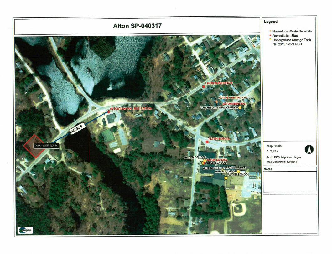
Through a review of the parcel on the NI IDES Oncstop database no contamination issues were found onsite however, there is a known remediation site within 696 feet of the parcel (Alton Central Fire Station). The parcel is also within two known source water protection areas (Pennichuck Water Works and Laconia Water Works). Through a review of the site on the NH Granite View web mapping tool it was determined that the site is not used for recreation nor within the floodplain of a nearby river or stream. The parcel is however within 250 feet of the Merrymeeting River. The parcel is also within farmland of local importance. The town of Alton, NH does not have prime wetland designation on any wetlands within the town. From the review of the parcel through the NFL Granit View web mapping tool, there does not appear to be any wetlands, surface waters, or building/structures on the parcel.
A cultural and archeological resources review was performed by the Bureau's Cultural Resource Manager and Cultural Resource Specialist. They reviewed the parcel for any potential above ground or below ground resources. They have determined that there is no potential to cause effect to above ground or below ground resources and have no concerns. A copy of the Cultural Resource Review has been included within.
El This bureau does not object to the transfer of the subject property pending further environmentallarchaeological review as noted above.
EA The Bureau of Environment does not object to the transfer of this property.
Recommended Environmental Classification for the Federal Highway Administration is
ri Class II — Categorical Exclusion (send to the Federal Highway Administration for concurrence)
Fl Class II — Programmatic Categorical Exclusion Other N/A
The Bureau of Environment does not support the transfer of this property.
Attached: Location Map: Railroad Layout or ROW Plan: fl Aerial Photo: Z NHNHB Letter:
Tax Map: Photographs:
Electronic copy to originating Bureau to be forwarded to: Rivers Management Advisory Committee: Lakes Management Advisory Committee: DES Rivers Coordinator (Designated Rivers):
IZ] Required El Not Required
fl Required E1 Not Required fl Required Not Required
S:\Environmcnt\SURPLUS LANDS \Alton \SP-040317 \Classification Review Blank.doc

FROM: Charles R. Schmidt, Py7 DATE: Administrator
AT (OFFICE):
(4187-0)
STATE OF NEW HAMPSHIRE INTER-DEPARTMENT COMMUNICATION
April 4,2017
Department of Transportation Bureau of Right-of-Way
SUBJECT: Disposal of State Owned Land in Alton
TO: James Marshall, Administrator, Highway Design
Alan Hanscom, District Engineer, District 3
Matt Urban, Wetland Program Manager, Environment Shelley Winters, Administrator, Rail and Transit
acquire a parcel of State owned land located on the northerly side of NH Route 140 in the Town of The Department has received a request from an abutter, Brandon Giuda who wishes to
AlUm.
The parcel consist of approximately 0.73+/- of an acre and was purchased due to a dam flooding in 1996.
Town records indicate this as being located in the Residential zone.
Would you please review this request to determine what portion of this requested parcel could be considered surplus to your Bureau's current or future needs for the purpose of disposal.
If your Bureau has an interest or concern relative to the disposal of these parcels, please notify this Bureau in writing within thirty (30) days.
According to the Stewardship and Oversight Agreement between DOT and FHWA, FHWA review of this parcel is not necessary.
If you have any questions pertaining to this request, please contact Cindy Poole of this Bureau at 271-3222.
Reference can be made to the following Plan: Alton Tax Map 28, Lot 5.
CRS/CAP/j1
Attachments
cc: Caleb Dobbins, Administrator, Highway Maintenance Dawn Dossett, Administrative Assistant, Commissioner's Office Phillip J. Miles, Chief of Property Management
TAPROPMNG1120 I 7 \ MemoskAlton Guida0328,doc

DeLorme Street Atlas USA® 2015 el DELORME • South Ellinghm,14
Ce er a nir
, ;ire
Harbor "'a„ IN)
iNekeln Village
01
Meredith
' .11..
1 • Hopei SF
Han
C.s..
. L: I •
.1 IVinningffilM
14nr .
• cl Lake nutlpesaukce • Wolleboro Falls
ttr waeopro
unl ‘z E tra
Wakefield
al ••••
Vier'
L? QtaTh,
1 ••• Ii
SanhornvIlle
innlsokim yob
Lachman, I
441 t f • ,
mont
th
• Alerrivrecting ,,,utakr: -
Alton Bay
• !Allan O73 acre1/2 24,
.11,r - Durham
Glinianton lion works
fa
cr'S •
Milton
arm! glen
Slick
4
Rochester
-'-nrifirC-H.ALgi aeon
1941121/ , t?„.4:•• %•,e- Me
Concordc,
'Northwo
' num SF • •
A • •
• a . I Oterffeld• e ,..
• ..lr 4;5. • • 4.. . , • ....,•
I i
..• da. l •IP /
t • • Not am . 8 oar Brook ,
SP , • _ ,
Data use sublet, to license.
0 DeLonne. DeLceme Street Atlas usAe 2015.
www.delorrne.COM
Scale 1 : 275,000 TN
MN 114 IMO 1 •••
4.34 ml Data Zoom 9.5

• _
CD
a
%QC [2.1f.„
-wet, N. 704,7e
-1 I
)- .
Copyrio ,t;t-Y2013 Na.tiona geographic ocery..:i.ci.leff
/te
Alton SP-040317
1:24,000
I I I I 0.9 Miles
Legend
in Surplus Parcel 0 0.225 0.45

I 360 Feet
1:1,800 Legend
Surplus Parcel
IIIIII 0 90 180
Alton SP-040317
if Map Scale
1:3.247
C NH DES http//des.nh.gov
Map Generated 67/2017
Alton SP-040317
Notes
Legend
Hazardous Waste Generato Remediation Sites Underground Storage Tank NH 2015 1-foot RGB
Legend
0 Source Water Protection ArE NH 2015 1-foot RGB
Map Scale 1:3,247
O NH DES. talpildassih.gov Map Generated: er1(2017
Notes
Alton SP-040317

Alton SP-040317
sc".." " rif ',IA I 14 " •
Legend
— State — County CI City/Town
Farmland fig call other values. £3 Conditional Prime Farmland n m areas are prime farmland
n Farmland of local importance Farmland of statewide Importance
Map Scale
1:6,494
O NH GRANIT, www.granitunh.edu
Map Generated: 6/7/2017
Notes

Alton SP-040317
Legend
— State — County Ei City/Town
Flood Hazard - Areas 1 pct. Annual Chance Flood Maury
U Roadway 02 pa Annual Chance Flood Han Area of Undetermined Flood Hann
05 Area Protected by Levee
Stream Centerlines — Perennial Stream
Imaiminem Stream
Artificial Paths Water Bodies
Lake/Pond U Reservoir
Estuary ZI Swamp/Marsh
Other Water Features 111 River
Mathew Inundation Area Dam/YVeir Caneri/Ditch
M Repels
Wetlands Estuarine and Marine Deepwater Estuarine and Marine Wetland Freshwater Emergent Wetland Freshwater Forested/Shrub Welark Freshwater Pond Lake Other Riyadh.
Map Scale
1:3,247
0 NH GRANIT, wv.w.grantt,unh.enu Map Generated: 617/2017
Notes

NEW HAMPSHIRE NATURAL HERfTAGE BUREAU DRED - DIVISION OF FORESTS & LANDS
I 72 PEMBROKE ROAD, CONCORD, NH 0330 I
PHONE: (603) 2 7 1 -22 14 FAX: (603) 27 1-6488
To: Sarah Large NH Department of Transportation 7 Hazen Drive Concord, NH 03302-0483
From: Sara Cairns, NH Natural Heritage Bureau
Date: 2017-06-29
Re: Review by NH Natural Heritage Bureau of request dated 2017-06-07
NUB File ID: 2796 Project type: Landowner Request
Town: Alton, NH Location: NHDOT Surplus land along NH Route 140 to the west of Merrymeeting
River between Elliot Road and Star Lane
I have searched our database for records of rare species and exemplary natural communities on the property(s) identified in your request. Our database includes known records for species officially listed as Threatened or Endangered by either the state of New Hampshire or the federal government, as well as species and natural communities judged by experts to be at risk in New Hampshire but not yet formally listed.
NHB records on the property(s): None
NHB records within one mile of the property(s): None
A negative result (no record in our database) does not mean that no rare species are present. Our data can only tell you of known occurrences, based on information gathered by qualified biologists and reported to our office. However, many areas have never been surveyed, or have only been surveyed for certain species. An on-site survey would provide better information on what species and communities are indeed present.
NOTE: This review cannot be used to satisfy a permit or other regulatory requirement to check for rare species or habitats that could be affected by a proposed project, since it provides detailed information only for records actually on the property.

0 E
cological System:

Aerial
View of Parcel from Rt. 140

View of Parcel from farther North Along Rt. 140
View of Parcel as Approach from the South along Rt. 140

Project ALTON SP-040317
Surplus Land - NHDOT Cultural Resources Review
For the purpose of compliance with regulations of the National Historic Preservation Act, the Advisory Council on Historic
Preservation's Procedures for the Protection of Historic Properties (36 CFR 800), the US Army Corps of Engineers' Appendix C,
and/or state regulation RSA 227-C:9, Directive for Cooperation in the Protection of Historic Resources, the NHDOT Cultural
Resources Program has reviewed the Surplus Land Application for potential Impacts to historic properties.
Proposed Project: Parcel (.73Acre; Tax Map 28, Lot 5 or parcel 28-5 on Mosaic) is situated on the north side of NH RI 140
(Frank C. Gilman Hwy), west of the MerrymeetIng River between Elliot Rd and Star Lane. It was purchased In 1996 due to dam
flooding. An abutter is requesting purchase. There are no buildings, structures, wetlands or surface waters identified.
Above Ground Review Known/approximate age of structure:
182 No Potential to Cause Effect/No Concerns No extant buildings or structures identified.
D Concerns:
Below Ground Review Recorded Archaeological site: Eyes (ON°
Nearest Recorded Archaeological Site Name gc Number: 27-8K-0127 "Places Sawmill"
OPre-Contact tElPost-Contact
Distance from Project Area: 3.58 miles (5.76 km) northwest of the project area
(81 No Potential to Cause Effect/No Concerns Although environmental data identifies the parcel as being within farmland of local importance, current aerials depict a relatively sparsely populated residential area. Nearest the road, the terrain gradually rises towards the northwest (@ 523-538 ft) for a short distance, although beyond this there is a relatively level area which contains a secondary understory of low scrub vegetation with some scattered trees on the periphery. No historic structures are noted in the vicinity of the study area on the 1892 Hurd map or the 1919 Alton NH USGS topographic quadrangle. The 1957 Alton topographic quadrangle depicts a former structure in the project vicinity. The 2015 Alton NH assessment does not indicate the presence of any structures. Most likely, the mid to late 20
1h century building construction, occupation, building demolition and grading has likely resulted in disturbed subsurface stratigraphy. ID Concerns:
Reviewed by:
`51' ,442- 65a4xcu. 7/27/2017
NHDOT Cultural Resources Staff Date:
S: \ Environment \ SURPLUS LANDS \ Alton \ SP-040317 \ ALTON SP-040317 Surplus Lend CR review.docx

.Nr/heor
117./illVi to
II /alums.'
A IATON PO. TOW/7 OF AMYX
BELK N AP CON. It nr,' Privity/
ir
.117n! Ai
ot!r/oln miL los i n,Lo, Lwow...rpm
' letrant,..rs
4.4•44.1.4
OP.Won•
40•0/V BAY CAMP
hatrAZA/12$
F tip
$
AVgll'
:I: :1111:44
-dr' , • .11Jfreftwel I . Aim /ilkilW . eyhi„„„ a
i • • MN keytenAl.
<,,/ mit1•:::".:Nar
3 '1 . • ii.,,, //1$4.•, 't. •• ...114,Y4fontArtv',,e,
- , tr#4. 4,.. ti yti ,4, 41 \.• \. ..:/ .1(r,v:;c/ii SFr, itrytir.ii,• ,1 11,:elanighlo
V""•• NOW•nrIVII41•/•4”.• - M,V1441/•,,
• 071'1.in
' ..8,1 Moth ie. , .11.71094
Phwrifif
.
.1
\•.t;;tl/ler ikr:ily,,,,,
':1l
I'
,
l
IN
•
•
A
lI'oI
CC
Th
dmtdl
ah
, : 1•IMtHeb•rbirtil ",go"
lr
.P/Ime...• '1 HWAMV:SinfifritIVVII, //, kr•V ;;e9ra4ll IS •
i•tinWelt n
*tar tati/o1
rS.II.4 find hi./ Proem tie IleIrgeVatinuern
IltribiSsIOrr Itirreg J4 /m3Il/i
••••.: Tarriollin .......
s VW'
.1'1'irtad,,,•• • • 9
/WA //11/Csa
—
'in,"
di!' IC f le II Xls,07111 - .11
.i. r irneloonot li,
.I•Imt• tm 14.,:,,,,,,,•/....
S. ,e 4' •11,4 • AI
,. I .. . 4,4,,,,,...rerLiii;;;;;, n.,,,,,,,„ N. .I. oenvpoi:
Ititvt.lithrni. . • C ./ II'li'm obey . (. $ft
''.. at i
'' • . \ ,.. ...lex l .1 :U to ,1:111; ..
PI R t
-4....
;4‘ - 7,..,'''';'; its,,..,•;11
--:• (1447//%7";;440/..v
./..., N / k ///9/•• m w„.„‘7,:. i 1.
iiiii/tolis:: is
,11”.4.1*.• b.
'
,
„_,--- -
/11flnityl . li/Irs la
SINfl40,

/Vs* 4k e", k 14 situ 11516--.

1919 Alton NH USGS topographic quadrangle