Embed Size (px)
Citation preview

State of California ⎯ The Resources Agency Primary # DEPARTMENT OF PARKS AND RECREATION HRI # DISTRICT RECORD Trinomial Page 1 of 22 *NRHP Status Code: 3S (CHRSC) *Resource Name or #: Capp and Howard Streets Mid-Block Fire Line Historic District D1. Historic Name: 1906 Fire Line D2. Common Name: None
*D3. Detailed Description (Discuss overall coherence of the district, its setting, visual characteristics, and minor features. List all elements of district.): The historic district is located within the Inner Mission North neighborhood. Contributors to the historic district are eight buildings that were constructed in two phases, including: four buildings that were constructed during the pre-fire period, from approximately 1865 to February 1906; and four buildings that were constructed during the post-fire period, from August 1906 to 1909. Contributors are mostly wood-frame residential structures that vary in types and architectural styles, as well as a brick church. The prevailing building typology includes: long, narrow building plans and arrangements of buildings that are suited to San Francisco’s high-density lots; ground floors with street-level or walk-up pedestrian entrances; and residential upper stories (where present) with projecting bay windows that are spaced at rhythmic intervals. Façade details typically include: building bases clad in brick or cast stone; wall surfaces clad in wood; detailed wood surrounds at entrances and windows; cast plaster ornament applied to exterior wall surfaces; and terminating entablatures. Pre-fire contributors are generally set back on their lots, while post-fire contributors are generally built out to the front and side property lines. (Continued on Page 3.)
*D4. Boundary Description (Describe limits of district and attach map showing boundary and district elements.): The historic district includes eight structures and six lots located on the northern portion of the block that is bounded by Capp Street, South Van Ness Avenue (formerly Howard Street), and 18th and 19th Streets. Four of the lots face Capp Street, and two of the lots face South Van Ness Avenue. (See map on Page 11.)
*D5. Boundary Justification: The boundary of the historic district contains a coherent grouping of thematic contributors, while excluding non-contributors (altered properties and non-thematic properties) to the extent feasible. In the areas immediately surrounding the historic district, fewer than half of the properties are considered both thematic and intact.
*D6. Significance: Theme: 1906 Fire Line; Mission District Architecture Area: Inner Mission North, San Francisco Period of Significance: circa 1865-1909 Applicable Criteria: National Register of Historic Places Criteria A & C
(Discuss district's importance in terms of its historical context as defined by theme, period of significance, and geographic scope. Also address the integrity of the district as a whole.)
Criterion A: The historic district is eligible for listing in the National Register of Historic Places under Criterion A at the local level, because it is associated with events that have made a significant contribution to the broad patterns of our history. The historic district contains buildings that are significant because they are located in direct proximity to the 1906 Fire Line, and they either survived, or are the products of the major rebuilding efforts that occurred on destroyed properties after, the earthquake and fires of April 1906. On this block, citizen firefighters in the Mission District halted the firestorm after it had already burned southwards for many blocks, and they successfully advanced the firebreak westward from Howard Street (South Van Ness Avenue) to Capp Street, which greatly contributed to the ultimate containment and extinguishing of the firestorm. The physical characteristics, locations, and distributions of the pre-fire survivors and the post-fire reconstruction properties convey the location of this rare mid-block 1906 Fire Line. Criterion C: The historic district is eligible for listing in the National Register of Historic Places under Criterion C at the local level, because: it embodies distinctive characteristics of type, period, and methods of construction; it possesses high artistic values; and it represents a significant and distinguishable entity whose components may lack individual distinction. The historic district embodies a range of residential (and institutional) architectural types that individually represent specific phases in the formative development of San Francisco’s Mission District, and that collectively convey broad patterns of development related to architectural styles, buildings practices, and residential densities within one of San Francisco’s oldest streetcar suburbs. These building include: an Italianate cottage; a Queen Anne multi-family house; a Classical flats building; a “Romeo” flats building; and a Gothic Revival church. The historic district also includes a very rare, vernacular bungalow cottage court associated with the early post-fire relief era. (Continued on Page 12.)
*D7. References (Give full citations including the names and addresses of any informants, where possible.): (See Page 21.)
*D8. Evaluator: Matt Weintraub, Preservation Planner Date: April 2011 Affiliation and Address: San Francisco Planning Dept., 1650 Mission St, Ste. 400, San Francisco, CA 94103-2479
DPR 523D (1/95) *Required information
State of California ⎯ The Resources Agency Primary # DEPARTMENT OF PARKS AND RECREATION HRI# CONTINUATION SHEET Trinomial Page 2 of 22 *Resource Name or # Capp and Howard Streets Mid-Block Fire Line Historic District *Recorded by: Matt Weintraub, San Francisco Planning Dept. *Date: April 2011 ⌧ Continuation Update
DPR 523L (1/95) *Required information
Table of Contents for Continuation Sheets Page Numbers *D3. Detailed Description (continued from Page 1) ............................................................3 to 9
Character-Defining Visual Characteristics ...............................................................3 Features and Elements ............................................................................................4
The 1906 Fire Line ......................................................................................5 Survivors......................................................................................................6 Relief and Reconstruction ...........................................................................7
Contributors (including list of properties)..................................................................10
*D4. Boundary Description (continued from Page 1) .........................................................11 Boundary Map ..........................................................................................................11
*D6. Significance (continued from Page 1)..........................................................................12 to 20
Historical Context .....................................................................................................12 Pioneer Settlement ......................................................................................12 Victorian-Era Suburbs .................................................................................13 1906 Earthquake and Fires .........................................................................14 Rebuilding and Up-building .........................................................................16 Community Resettlement ............................................................................18
Integrity .....................................................................................................................19 *D7. References (continued from Page 1) ...........................................................................21 to 22
State of California ⎯ The Resources Agency Primary # DEPARTMENT OF PARKS AND RECREATION HRI# CONTINUATION SHEET Trinomial Page 3 of 22 *Resource Name or # Capp and Howard Streets Mid-Block Fire Line Historic District *Recorded by: Matt Weintraub, San Francisco Planning Dept. *Date: April 2011 ⌧ Continuation Update
DPR 523L (1/95) *Required information
*D3. Detailed Description: (continued from Page 1)
Character-Defining Visual Characteristics The visual characteristics of the overall historic district include but may not be limited to:
• The distinctive layout of varied structures on Capp Street that is directly related to specific events that
occurred during and after the 1906 earthquake and fires, which includes: Victorian-era “fire survivor” properties that are located directly south of the 1906 Fire Line; and relief-era and Edwardian-era “post-fire reconstruction” properties that are located directly north of the 1906 Fire Line.
• The chronological arrangement of structures located on Capp Street that is visually representative of
development patterns in San Francisco’s Mission District, including: an Italianate cottage (built circa 1865); a Queen Anne multi-family house (built 1902); a vernacular bungalow cottage court (built August 1906); and a “Romeo” flats building (built 1909).
• The structures located on South Van Ness Avenue that are also directly associated with the 1906 earthquake
and fires, as well as with the historical development of the Mission District, including: a “fire survivor” Classical flats building (built 1903); and a Gothic Revival church (built February 1906) that was damaged by the earthquake, and that was repaired and reconstructed after it survived the fires.
The visual characteristics of individual contributing properties include but may not be limited to:
• Architectural styles and/or types, including: Italianate (tall narrow windows, overhanging cornices/eaves with
carved brackets); Queen Anne (curved window bays, arched porticos, balconies/belfries, gable roofs and dormers, ornamented spandrels, corner brackets); Classical/Roman Revival (columns/pilasters; pediments/porticos; boxed eaves with cornices, dentils, modillions, frieze bands); Gothic Revival (pointed
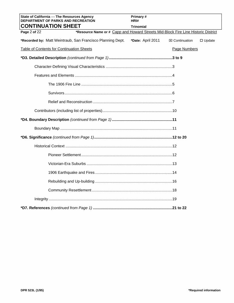
Four lots containing six structures that were constructed during the late 19th century and early 20th century, located on the east side of Capp Street, around the mid-block 1906 Fire Line. View northeast. San Francisco Planning Department.
Two structures that were constructed during the early 20th
century, located on the west side of South Van Ness Avenue (formerly Howard Street), adjacent to the mid-block 1906 Fire Line. View southwest. San Francisco Planning Department.
State of California ⎯ The Resources Agency Primary # DEPARTMENT OF PARKS AND RECREATION HRI# CONTINUATION SHEET Trinomial Page 4 of 22 *Resource Name or # Capp and Howard Streets Mid-Block Fire Line Historic District *Recorded by: Matt Weintraub, San Francisco Planning Dept. *Date: April 2011 ⌧ Continuation Update
DPR 523L (1/95) *Required information
arches, castellation, steep gables, broken rooflines); as well as examples of vernacular construction that represent the early post-fire period (small, identical all-wood cottages arranged like a bungalow court).
• Height, form and massing that varies widely among individual structures, including: heights from one to three-
and-a-half stories (as well as a very tall two-story church); façades with or without bay windows; and rooflines that may be hipped, gable, flat, or complex.
• Wood cladding on residential buildings (including cove/shiplap siding and flush siding), and brick cladding on
the church. • Entrance/fenestration patterns that are orderly and symmetrical, and which utilize small porches, wood doors,
wood windows (typically double-hung), and bay windows (angled and rounded).
• Ornamentation and detailing, which typically include: wood cornices and trim; wood surrounds at entrances and windows; porticos, hoods, and/or entablatures; cast plaster ornament applied to flat façade surfaces; and other features such as decorative window shutters on the cottages, and decorative clerestories and steeple on the church.
Features and Elements The historic district is a small, compact grouping of residential properties that are located on Capp Street, a typical residential street, and South Van Ness Avenue (formerly Howard Street), a major transportation thoroughfare that historically functioned as a residential boulevard, in the Inner Mission North. The properties on Capp Street and South Van Ness Avenue are approximately back-to-back with each other. The properties are related thematically by specific historical events related to the 1906 earthquake and fires, and visually as a progression of architectural styles and types that are associated with the broader historical development of the streetcar suburbs of San Francisco’s Mission District. The following sections describe the features and elements that comprise the historic district, including areas, sites, groupings of structures, individual buildings, and their characteristics.
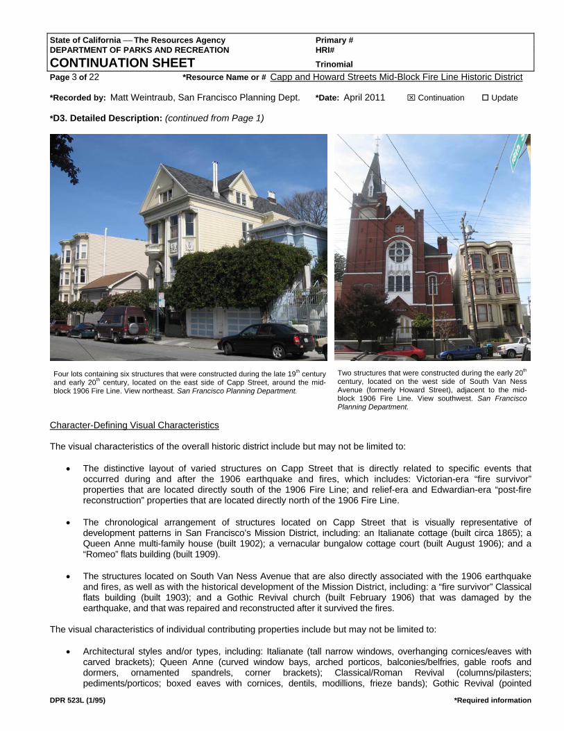
The 1906 Fire Line at Howard Street (South Van Ness Avenue), north of the historic district, in the aftermath of the disaster. Wide boulevards such as Howard Street were typical firebreaks. Most of the front-line “fire survivors” (in background) were ruined by the earthquake. View east. San Francisco History Center, San Francisco Public LIbrary (Historical Photograph Collection Photo Id# AAC-3276).
The 1906 Fire Line at Howard Street (South Van Ness Avenue), north of the historic district, during debris clearance. Tracks for rail cars to carry debris away were installed on Capp Street (in foreground). View northeast. San Francisco History Center, San Francisco Public LIbrary (Historical Photograph Collection Photo Id# AAC-3252).
State of California ⎯ The Resources Agency Primary # DEPARTMENT OF PARKS AND RECREATION HRI# CONTINUATION SHEET Trinomial Page 5 of 22 *Resource Name or # Capp and Howard Streets Mid-Block Fire Line Historic District *Recorded by: Matt Weintraub, San Francisco Planning Dept. *Date: April 2011 ⌧ Continuation Update
DPR 523L (1/95) *Required information
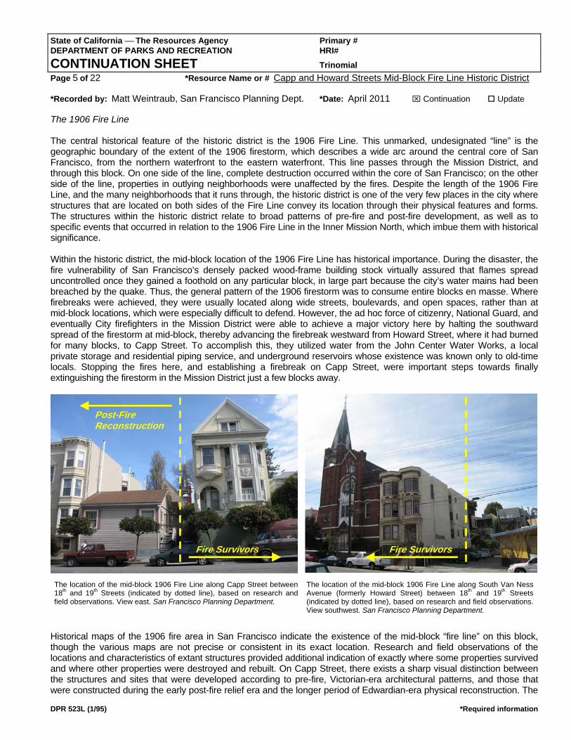
The 1906 Fire Line The central historical feature of the historic district is the 1906 Fire Line. This unmarked, undesignated “line” is the geographic boundary of the extent of the 1906 firestorm, which describes a wide arc around the central core of San Francisco, from the northern waterfront to the eastern waterfront. This line passes through the Mission District, and through this block. On one side of the line, complete destruction occurred within the core of San Francisco; on the other side of the line, properties in outlying neighborhoods were unaffected by the fires. Despite the length of the 1906 Fire Line, and the many neighborhoods that it runs through, the historic district is one of the very few places in the city where structures that are located on both sides of the Fire Line convey its location through their physical features and forms. The structures within the historic district relate to broad patterns of pre-fire and post-fire development, as well as to specific events that occurred in relation to the 1906 Fire Line in the Inner Mission North, which imbue them with historical significance. Within the historic district, the mid-block location of the 1906 Fire Line has historical importance. During the disaster, the fire vulnerability of San Francisco’s densely packed wood-frame building stock virtually assured that flames spread uncontrolled once they gained a foothold on any particular block, in large part because the city’s water mains had been breached by the quake. Thus, the general pattern of the 1906 firestorm was to consume entire blocks en masse. Where firebreaks were achieved, they were usually located along wide streets, boulevards, and open spaces, rather than at mid-block locations, which were especially difficult to defend. However, the ad hoc force of citizenry, National Guard, and eventually City firefighters in the Mission District were able to achieve a major victory here by halting the southward spread of the firestorm at mid-block, thereby advancing the firebreak westward from Howard Street, where it had burned for many blocks, to Capp Street. To accomplish this, they utilized water from the John Center Water Works, a local private storage and residential piping service, and underground reservoirs whose existence was known only to old-time locals. Stopping the fires here, and establishing a firebreak on Capp Street, were important steps towards finally extinguishing the firestorm in the Mission District just a few blocks away.
Historical maps of the 1906 fire area in San Francisco indicate the existence of the mid-block “fire line” on this block, though the various maps are not precise or consistent in its exact location. Research and field observations of the locations and characteristics of extant structures provided additional indication of exactly where some properties survived and where other properties were destroyed and rebuilt. On Capp Street, there exists a sharp visual distinction between the structures and sites that were developed according to pre-fire, Victorian-era architectural patterns, and those that were constructed during the early post-fire relief era and the longer period of Edwardian-era physical reconstruction. The
Fire Survivors
Post-Fire Reconstruction
Fire Survivors
The location of the mid-block 1906 Fire Line along Capp Street between 18th and 19th Streets (indicated by dotted line), based on research and field observations. View east. San Francisco Planning Department.
The location of the mid-block 1906 Fire Line along South Van Ness Avenue (formerly Howard Street) between 18th and 19th Streets(indicated by dotted line), based on research and field observations. View southwest. San Francisco Planning Department.
State of California ⎯ The Resources Agency Primary # DEPARTMENT OF PARKS AND RECREATION HRI# CONTINUATION SHEET Trinomial Page 6 of 22 *Resource Name or # Capp and Howard Streets Mid-Block Fire Line Historic District *Recorded by: Matt Weintraub, San Francisco Planning Dept. *Date: April 2011 ⌧ Continuation Update
DPR 523L (1/95) *Required information
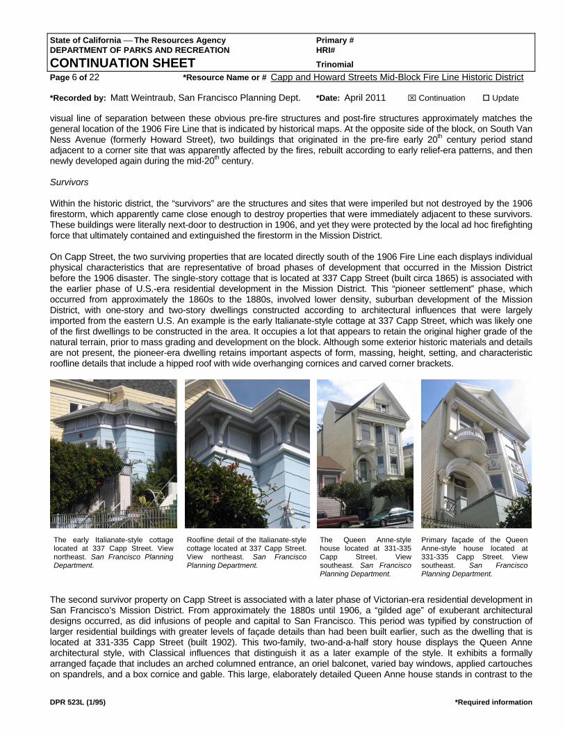
visual line of separation between these obvious pre-fire structures and post-fire structures approximately matches the general location of the 1906 Fire Line that is indicated by historical maps. At the opposite side of the block, on South Van Ness Avenue (formerly Howard Street), two buildings that originated in the pre-fire early 20th century period stand adjacent to a corner site that was apparently affected by the fires, rebuilt according to early relief-era patterns, and then newly developed again during the mid-20th century. Survivors Within the historic district, the “survivors” are the structures and sites that were imperiled but not destroyed by the 1906 firestorm, which apparently came close enough to destroy properties that were immediately adjacent to these survivors. These buildings were literally next-door to destruction in 1906, and yet they were protected by the local ad hoc firefighting force that ultimately contained and extinguished the firestorm in the Mission District. On Capp Street, the two surviving properties that are located directly south of the 1906 Fire Line each displays individual physical characteristics that are representative of broad phases of development that occurred in the Mission District before the 1906 disaster. The single-story cottage that is located at 337 Capp Street (built circa 1865) is associated with the earlier phase of U.S.-era residential development in the Mission District. This “pioneer settlement” phase, which occurred from approximately the 1860s to the 1880s, involved lower density, suburban development of the Mission District, with one-story and two-story dwellings constructed according to architectural influences that were largely imported from the eastern U.S. An example is the early Italianate-style cottage at 337 Capp Street, which was likely one of the first dwellings to be constructed in the area. It occupies a lot that appears to retain the original higher grade of the natural terrain, prior to mass grading and development on the block. Although some exterior historic materials and details are not present, the pioneer-era dwelling retains important aspects of form, massing, height, setting, and characteristic roofline details that include a hipped roof with wide overhanging cornices and carved corner brackets.
The second survivor property on Capp Street is associated with a later phase of Victorian-era residential development in San Francisco’s Mission District. From approximately the 1880s until 1906, a “gilded age” of exuberant architectural designs occurred, as did infusions of people and capital to San Francisco. This period was typified by construction of larger residential buildings with greater levels of façade details than had been built earlier, such as the dwelling that is located at 331-335 Capp Street (built 1902). This two-family, two-and-a-half story house displays the Queen Anne architectural style, with Classical influences that distinguish it as a later example of the style. It exhibits a formally arranged façade that includes an arched columned entrance, an oriel balconet, varied bay windows, applied cartouches on spandrels, and a box cornice and gable. This large, elaborately detailed Queen Anne house stands in contrast to the
The early Italianate-style cottage located at 337 Capp Street. View northeast. San Francisco Planning Department.
The Queen Anne-style house located at 331-335 Capp Street. View southeast. San Francisco Planning Department.
Roofline detail of the Italianate-style cottage located at 337 Capp Street. View northeast. San Francisco Planning Department.
Primary façade of the Queen Anne-style house located at 331-335 Capp Street. View southeast. San Francisco Planning Department.

State of California ⎯ The Resources Agency Primary # DEPARTMENT OF PARKS AND RECREATION HRI# CONTINUATION SHEET Trinomial Page 7 of 22 *Resource Name or # Capp and Howard Streets Mid-Block Fire Line Historic District *Recorded by: Matt Weintraub, San Francisco Planning Dept. *Date: April 2011 ⌧ Continuation Update
DPR 523L (1/95) *Required information
simpler and plainer Italianate cottage, and it evokes the character of nearby Howard Street’s “mansion row”, which was one of the grander neighborhoods of the Mission District during the late 19th century. At the opposite side of the block, on South Van Ness Avenue (formerly Howard Street), two other survivors also stand adjacent to the 1906 Fire Line. The three-story residential structure located at 714-718 South Van Ness Avenue (built 1903) represents another phase in the pre-fire development of the Mission District. The three-family structure is indicative of increases in residential densities in the Mission District that occurred around the turn of the 20th century, as well as shifts in architectural tastes towards formal Classicism following several decades of Victorian-era exuberance. This residential flats building features symmetrical bay windows, clean horizontal cornice lines and denticulation, paired entry columns, and a generally uncluttered façade.
Also on former Howard Street is found the Trinity Evangelical Lutheran Church, located at 720 South Van Ness Avenue. According to the building’s cornerstone date of “Feb. 11 1906”, this church was originally erected right before the great earthquake and fires of April 1906. Its fire-resistant brick cladding and its height that would have allowed for firefighting from above may have contributed to successful efforts to stave off the firestorm from adjacent structures. However, the edifice was damaged in the quake itself, and was partially reconstructed in 1907. During the early 20th century, the church served a primarily German congregation from the Mission District and nearby neighborhoods. Relief and Reconstruction Within the historic district, the “relief” and “reconstruction” properties are the structures and sites that were apparently destroyed by the 1906 firestorm, and that were physically rebuilt in the months and years that followed the disaster. On Capp Street, two properties that are located directly north of the 1906 fire “survivors” each displays individual physical characteristics that are representative of two phases of post-fire physical rebuilding that occurred in the Mission District, the relief phase and the upbuilding phase. The early relief-era phase of rebuilding was typified by the construction of small vernacular dwellings that were intended to provide basic shelter for refugees until larger and more substantial structures could be erected. Relief-era housing included structures that were built by the U.S. Army as part of the official relief effort, as well as those that were erected by individuals without any central planning or subsidies, such as those that are found within the historic district. Several of the earliest privately owned post-fire dwellings to be constructed anywhere in the City are located at 325, 325A, and
The Classical residential flats located at 714-718 South Van Ness Avenue. View west. San Francisco Planning Department.
The Trinity Evangelical Lutheran Church located at 720 South Van Ness Avenue. View southwest. San Francisco Planning Department.
The cornerstone of the Trinity Evangelical Lutheran Church with date of “Feb 11 1906”. View northwest. San Francisco Planning Department.

State of California ⎯ The Resources Agency Primary # DEPARTMENT OF PARKS AND RECREATION HRI# CONTINUATION SHEET Trinomial Page 8 of 22 *Resource Name or # Capp and Howard Streets Mid-Block Fire Line Historic District *Recorded by: Matt Weintraub, San Francisco Planning Dept. *Date: April 2011 ⌧ Continuation Update
DPR 523L (1/95) *Required information
325B Capp Street. These three tiny cottages indicate vernacular methods of construction, are based on very small and simple plans, and display no elaborate ornamentation, which were all characteristics of working-class refugee-built housing. However, they also display higher quality materials and craftsmanship than was typical of most expedient relief-era housing, and they were carefully arranged and constructed on the site rather than moved and expanded, as occurred with most relief-era housing. On August 30, 1906, a mere four months after the earthquake and fires devastated most of San Francisco’s buildings, infrastructure, and economy, construction began on these small cottages on a lot that appears to have been located at the very edge of the firestorm. They were constructed by the Pacific Coast Bldg. Co., who were located nearby at 2203 Mission Street, for W.J. Little, who lived at nearby 427 Capp Street. These wood-frame, wood-clad dwellings were erected on brick foundations at a cost of $700 each. They were arranged as a bungalow court, lined up one behind the other on a deep narrow lot with entrances that faced sideways along a common access path. This bungalow court arrangement allowed for greater overall residential densities on lots while developing them with smaller, single-family structures. Though small and simple, Little’s refugee cottages display minor design flourishes that are unusual such as decorative window shutters, slight cornice returns at the gable ends, and small wood porches with cross-framed panels. Other architectural features include shiplap cladding, small overhanging gable eaves, flat window trim, and paneled sash doors. Located directly on the mid-block 1906 Fire Line, this extremely rare grouping of post-fire refugee bungalows provides an important associative link to the historical conditions of refugee housing.
As the post-fire reconstruction progressed, a pattern of upbuilding emerged in the Inner Mission North, whereby lots were rebuilt at higher densities and greater scales than had existed before the 1906 disaster. This occurred in response to the citywide housing crisis and to a booming residential rental market, which persisted for several years as displaced communities and post-fire newcomers swelled the population of the Mission District. The residential structures known as Romeo and Juliet flats, or Romeo flats, provided the housing alternative with the greatest density. Depending on building heights, standard-width Romeo flats contained four to eight units, arranged in two mirrored, vertical stacks of long narrow apartment units that corresponded to the bay window divisions on the primary façades. At the center of the primary façades, common entrances at the sidewalks accessed internal stairwells that led to individual apartment doors at all levels. The hallmark features of Romeo flats buildings were the central stairwells and balconies, either open or punctuated with large windows, which allowed for street call-ups, i.e.., Shakespeare’s Romeo and Juliet balcony scene, which provided the impetus for this building type’s common moniker. As with Edwardian-era flats in general, Romeo flats most often utilized Classical features and designs.
The relief-era bungalow court located at 325, 325A, and 325B Capp Street. View northeast. San Francisco Planning Department.
The entrances to the bungalows located at 325, 325A, and 325B Capp Street. View northeast. San Francisco Planning Department.
The Edwardian-era Romeo flats building located at 319-323 Capp Street. View southeast. San Francisco Planning Department.
State of California ⎯ The Resources Agency Primary # DEPARTMENT OF PARKS AND RECREATION HRI# CONTINUATION SHEET Trinomial Page 9 of 22 *Resource Name or # Capp and Howard Streets Mid-Block Fire Line Historic District *Recorded by: Matt Weintraub, San Francisco Planning Dept. *Date: April 2011 ⌧ Continuation Update
DPR 523L (1/95) *Required information
Within the historic district, the Romeo flats building that is located at 319-323 Capp Street (built 1909) is a typical example of the upbuilding phase of post-fire reconstruction that occurred after the relief era. This three-story, six-unit structure indicated a vertical adaptation to higher residential densities that ultimately proved to be far more common in San Francisco than area-intensive horizontal arrangements of bungalows. The symmetrical façade of the Romeo flats includes Classical pilasters and pediments at the central openings, cornices at all levels, and a broad horizontal modillion cornice at the roofline. The structure also includes a small automobile garage that was inserted beneath a bay window circa 1925, with original doors.
State of California ⎯ The Resources Agency Primary # DEPARTMENT OF PARKS AND RECREATION HRI# CONTINUATION SHEET Trinomial Page 10 of 22 *Resource Name or # Capp and Howard Streets Mid-Block Fire Line Historic District *Recorded by: Matt Weintraub, San Francisco Planning Dept. *Date: April 2011 ⌧ Continuation Update
DPR 523L (1/95) *Required information
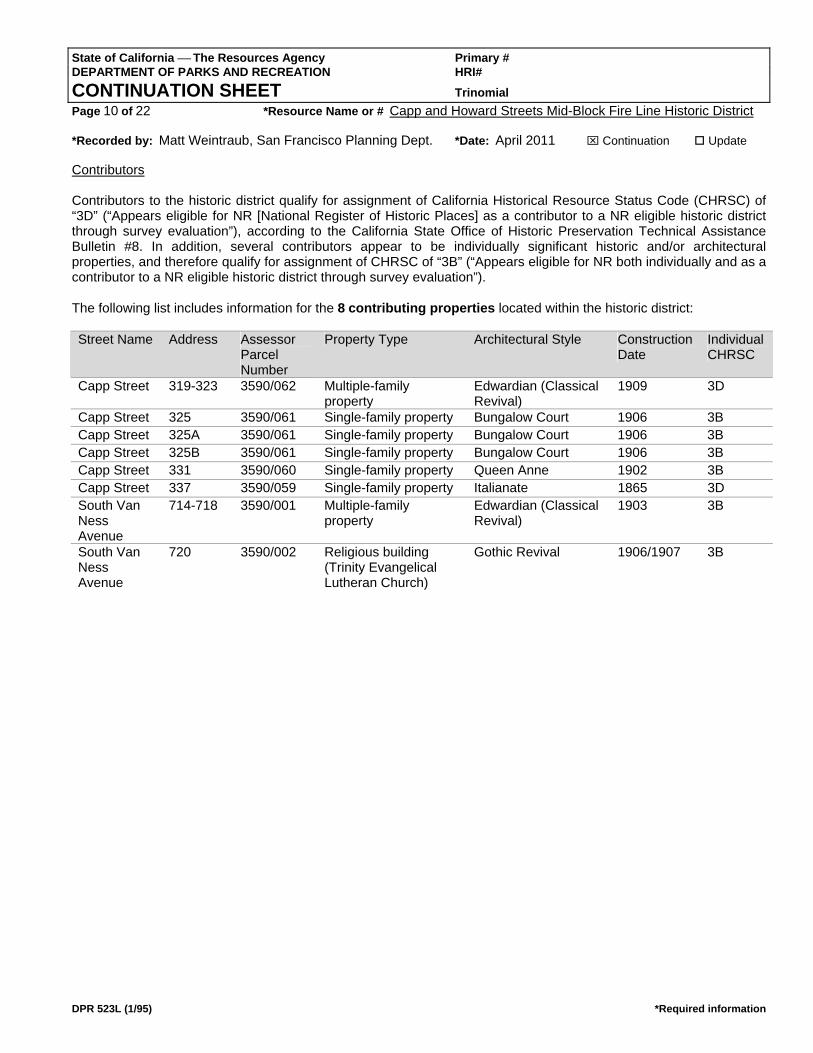
Contributors Contributors to the historic district qualify for assignment of California Historical Resource Status Code (CHRSC) of “3D” (“Appears eligible for NR [National Register of Historic Places] as a contributor to a NR eligible historic district through survey evaluation”), according to the California State Office of Historic Preservation Technical Assistance Bulletin #8. In addition, several contributors appear to be individually significant historic and/or architectural properties, and therefore qualify for assignment of CHRSC of “3B” (“Appears eligible for NR both individually and as a contributor to a NR eligible historic district through survey evaluation”). The following list includes information for the 8 contributing properties located within the historic district: Street Name Address Assessor
Parcel Number
Property Type Architectural Style Construction Date
Individual CHRSC
Capp Street 319-323 3590/062 Multiple-family property
Edwardian (Classical Revival)
1909 3D
Capp Street 325 3590/061 Single-family property Bungalow Court 1906 3B Capp Street 325A 3590/061 Single-family property Bungalow Court 1906 3B Capp Street 325B 3590/061 Single-family property Bungalow Court 1906 3B Capp Street 331 3590/060 Single-family property Queen Anne 1902 3B Capp Street 337 3590/059 Single-family property Italianate 1865 3D South Van Ness Avenue
714-718 3590/001 Multiple-family property
Edwardian (Classical Revival)
1903 3B
South Van Ness Avenue
720 3590/002 Religious building (Trinity Evangelical Lutheran Church)
Gothic Revival 1906/1907 3B
State of California ⎯ The Resources Agency Primary # DEPARTMENT OF PARKS AND RECREATION HRI# CONTINUATION SHEET Trinomial Page 11 of 22 *Resource Name or # Capp and Howard Streets Mid-Block Fire Line Historic District *Recorded by: Matt Weintraub, San Francisco Planning Dept. *Date: April 2011 ⌧ Continuation Update
DPR 523L (1/95) *Required information
*D4. Boundary Description: (continued from Page 1)
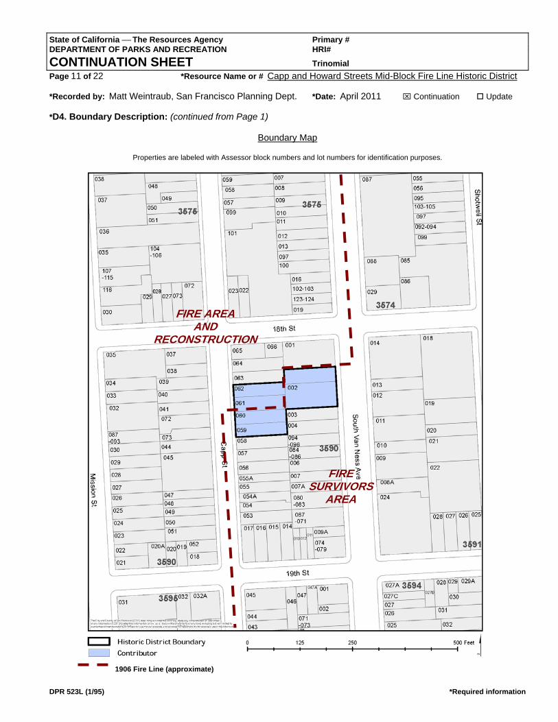
Boundary Map
Properties are labeled with Assessor block numbers and lot numbers for identification purposes.
1906 Fire Line (approximate)
FIRE AREA AND
RECONSTRUCTION
FIRE SURVIVORS
AREA
State of California ⎯ The Resources Agency Primary # DEPARTMENT OF PARKS AND RECREATION HRI# CONTINUATION SHEET Trinomial Page 12 of 22 *Resource Name or # Capp and Howard Streets Mid-Block Fire Line Historic District *Recorded by: Matt Weintraub, San Francisco Planning Dept. *Date: April 2011 ⌧ Continuation Update
DPR 523L (1/95) *Required information
*D6. Significance: (continued from Page 1) The historic district, a significant and distinguishable entity, qualifies for assignment of California Historical Resource Status Code (CHRSC) of “3S” (“Appears eligible for NR [National Register of Historic Places] as an individual property through survey evaluation”) according to the California State Office of Historic Preservation Technical Assistance Bulletin #8. The California Office of Historic Preservation Technical Assistance Bulletin #6 indicates that properties that are determined eligible for listing in the National Register of Historical Places (National Register) are also eligible for listing in the California Register of Historical Resources (California Register). According to Bulletin #6, the National Register and the California Register are extremely similar because the California Register was consciously designed on the model of the National Register. Therefore, the historic district and its contributors are also determined eligible for listing in the California Register under Criterion 1 (which is approximately equivalent to National Register Criterion A) at the local level, because it is associated with events that have made a significant contribution to the broad patterns of local or regional history. Also, the historic district and its contributors are determined eligible for listing in the California Register under Criterion 3 (which is approximately equivalent to National Register Criterion C) at the local level, because it embodies the distinctive characteristics of type, period, region, and methods of construction, and it possesses high artistic values. Historical Context After the Inner Mission North was destroyed by the earthquake and fires of April 1906, the initial “relief” phase, which extended into 1908, was characterized by small ad hoc cottages and shacks that provided immediate, temporary shelter for the desperate refugee population. The second phase of “rebuilding” involved the construction of permanent replacement structures, which in some instances began immediately after the 1906 disaster, and in other instances continued well into the 1910s. Within the historic district, which is part of the most urbanized area of the Inner Mission North, only a very few small, plain buildings remain intact from the early “relief” era. Most of the extant buildings represent the permanent “rebuilding” period, during which substantial multiple-story structures were erected to replace either destroyed buildings and/or the earliest temporary structures. The historical context of the 1906 earthquake and the post-fire period of rebuilding and recovery in the Inner Mission North is further established in the following sections, which is largely excerpted from the San Francisco Planning Department’s National Register of Historic Places Multiple Property Documentation Form (NPS Form 10-900-b), Historic Neighborhoods of the Mission District, San Francisco, California, which was adopted by San Francisco Historic Preservation Commission Motion No. 93 on November 17, 2010. Pioneer Settlement By the late 1860s and early 1870s, home construction was lucrative in the Mission District. Most residential development occurred around the horse-drawn omnibus and streetcar thoroughfares that ran through the Inner Mission North and the central-southern Mission District. The Real Estate Circular of February, 1868, proclaimed (without mentioning transit improvements):
“An active demand has been noticeable for lots lying within the boundary of 18th, 26th, Valencia, and Castro Streets [Horner’s Addition]. This locality is occupied by rolling hills and table land, and heretofore has not been in favor with purchasers…But the perfect nature of its title, the fine view which is obtained from most of the land, and the good drainage which it will have, have lately operated favorably in elevating its prices.”
In 1872, the Circular reported further on the area located directly in the heart of the Mission valley, and inclusive of all four major transit lines: “Between Folsom and Guerrero, Eighteenth and Twenty-third, [there are] now about 300 first and second class residences. Many of the former are not surpassed by any in the City.” During the 1870s, the Real Estate Circular advocated replacement of the horse-drawn streetcars and transit expansion in order to ensure continued residential development.
State of California ⎯ The Resources Agency Primary # DEPARTMENT OF PARKS AND RECREATION HRI# CONTINUATION SHEET Trinomial Page 13 of 22 *Resource Name or # Capp and Howard Streets Mid-Block Fire Line Historic District *Recorded by: Matt Weintraub, San Francisco Planning Dept. *Date: April 2011 ⌧ Continuation Update
DPR 523L (1/95) *Required information
Construction of single-family dwellings prevailed during the pioneer era. Variations in sizes, styles, and lot layouts reflected a pattern of individualized development, as landowners built according to their own means and needs. Some early dwellings were pre-fabricated houses shipped “around the horn” from the eastern U.S.; some were moved from elsewhere in San Francisco (including the Mission District); and others were ordered from local mills and assembled on site. The earliest pioneer residences in the Mission were small, simple, and utilitarian: cottages and farmhouses, with square footprints and gable roofs (with additions, cross-gable), designed in folk-vernacular versions of Greek Revival, Gothic Revival, and early Italianate-style. The addition of “false-front” façades with cornices, bay windows, and “gingerbread” became popular as a way to disguise traditional gable boxes. Even true Italianate-style “villa” houses and mansions were built, rambling and fully rendered at all elevations. Residential lots in the Mission, particularly larger plots, commonly included outbuildings and structures such as wagon-houses, fuel sheds, wells, tank-houses, barns, stables, and livestock pens. In addition to development of single lots, and sometimes two or three lots, by individual landowners, some speculative builders obtained larger tracts, built regular rows of “spec” homes with similar plans and finishes, and sold the finished products. Early row-houses, including attached versions where dwellings shared walls as well as detached versions separated by side yards, followed the popular Italianate-style “town-house” model that emphasized vertical front façades with heavy cornices. An early speculative builder, The Real Estate Associates constructed over a hundred houses in the Inner Mission North, filling out several blocks that were eventually bisected by the 1906 firestorm. According to Waldorn and Woodbridge’s Victoria’s Legacy:
“Many City homes of the 1870s were the products of The Real Estate Associates (TREA), a development company that built more than one thousand houses before declaring bankruptcy in 1881. An enormous operation for the time, TREA was San Francisco’s first major tract builder. According to their claims, from 1870 to 1875 they had produced ‘more detached homes than any other person or company in the United States in a similar time span.’ “ (Page 13)
Victorian-Era Suburbs The late 19th century witnessed renewed building activity in San Francisco, as the population surged and newcomers and established citizens alike increasingly sought to live further from the crowded downtown and South-of-Market areas. The city fanned outward along new transit lines that ran through the Mission District as well as to entirely new outlying neighborhoods to the west and south. The City’s building industry grew tremendously to meet the demand for housing. According to Waldhorn and Woodbridge in Victoria’s Legacy:
“In the 1880s and 1890s, the two major decades of home construction of the century, more than fifteen hundred individuals were building, moving and remodeling houses in San Francisco!... The mid-1880s were boom years for San Francisco; construction started on at least four new buildings each working day. More cable car lines were extended to outlying neighborhoods, creating a flurry of land sales and auctions.” (Pages 8, 14)
Initially, San Francisco’s pioneer-era builders attempted to recreate in wood the features and appearances of buildings in the eastern U.S. and Europe, where a tradition of brick and stone construction existed. But by the 1880s and 1890s, local architects and builders had expanded the architectural lexicon to suit the abundant and pliable Pacific Coast redwood. In Victoria’s Legacy, Waldhorn and Woodbridge described how the use of wood as the primary building material in San Francisco influenced the Victorian-era architectural styles that succeeded Italianate in fashion during the late 19th century:
“The most popular house style of the eighties was a vertical-looking rowhouse with a three-sided rectangular bay window, whose ninety-degree angles were much easier to mass-produce than the five-sided bay of the seventies with its complex mitering and molding. The surfaces of the homes of this decade, now called “San Francisco Sticks,” were laden with an abundance of wooden enrichment…[The next] decade of building brought a radical change in house style…completely different from the vertical, rectangular-bayed false-gabled rowhouses of the eighties. These
State of California ⎯ The Resources Agency Primary # DEPARTMENT OF PARKS AND RECREATION HRI# CONTINUATION SHEET Trinomial Page 14 of 22 *Resource Name or # Capp and Howard Streets Mid-Block Fire Line Historic District *Recorded by: Matt Weintraub, San Francisco Planning Dept. *Date: April 2011 ⌧ Continuation Update
DPR 523L (1/95) *Required information
“premium” homes had towers and true gabled roofs, with attic space behind them. They featured horizontal lines – plaster garlanding, frieze bands and belt cornices – rather than the vertical lines of the eighties…These structural and decorative elements define the style the today we call the Queen Anne…” (Pages 14, 19)
By the turn of the century, Queen Anne and Beaux-Arts-influenced styles had become the favorite choices of architects for high-style creations; related styles such as Eastlake, Shingle, and First Bay Tradition also flourished in the late 19th century. Yet the tried-and-true Italianate style remained a staple of residential design through the 1890s. Contractors continued to mass produce working-class cottages and flats based upon the early (and comparatively cheap) “false-front” Italianate model: simple residential boxes with flat façades and tall parapets, decorated with milled cornices and brackets. These economical, traditional housing solutions did not fall out of favor until the end of the 19th century. Some houses, those of the “Gilded Age” upper classes, and particularly architect-designed homes, stood out from the contractors’ row-houses and the owner-built, catalog-bought creations. Though not typical of the Mission District, quite a few “high-style” deluxe houses and mansions were constructed in certain neighborhoods. These large homes featured individualized (not mass produced) designs, with fully-detailed elevations at all sides, custom-made decorations, and expensive materials such as brick and stone. Still, even these carefully designed and crafted homes of the affluent followed a familiar façade pattern at the street, repeated throughout late 19th century and early 20th century residential architecture: bilateral division, with decorated entrance at one side, one or more bay windows, and capped by a heavily detailed cornice or gable.
1906 Earthquake and Fire The great earthquake of April 18th, 1906, and the citywide fires that followed, were defining for the Mission District, as for all of San Francisco. While the earthquake itself destroyed mostly brick structures and buildings that stood on filled land, it also started dozens of major fires, most of them in the densely crowded South-of-Market area of tenements and industry. Firefighting was hampered by broken water mains, and the fires spread and merged uncontrolled, feeding on the primarily wood building stock. The ensuing conflagration, whose severity was compounded by numerous tactical errors on the part of city officials and army commanders, utterly consumed four-fifths of San Francisco, including approximately 28,000 buildings, over the next three days. Thousands of lives were lost. “The flames ravaged the financial district, the downtown commercial center, much of the industrial sector, and the city’s most densely populated residential neighborhoods north and south of Market. The economic and social core of the west’s greatest metropolis was in ruins.” During the second night of disaster, the conflagration moved into the Mission District from the north, where two separate firestorms, the South-of-Market blaze and the Hayes Valley “ham-and-eggs” fire, had combined. As the flames spread
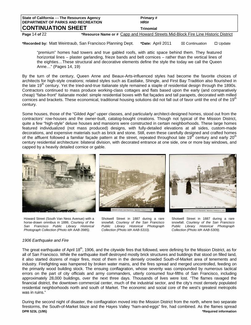
Howard Street (South Van Ness Avenue) with a horse-drawn omnibus in 1886. Courtesy of the San Francisco Public Library Historical Photograph Collection (Photo Id# AAB-3985).
Shotwell Street in 1887 during a rare snowfall. Courtesy of the San Francisco Public Library Historical Photograph Collection (Photo Id# AAB-5310).
Shotwell Street in 1887 during a rare snowfall. Courtesy of the San Francisco Public Library Historical Photograph Collection (Photo Id# AAB-5309).
State of California ⎯ The Resources Agency Primary # DEPARTMENT OF PARKS AND RECREATION HRI# CONTINUATION SHEET Trinomial Page 15 of 22 *Resource Name or # Capp and Howard Streets Mid-Block Fire Line Historic District *Recorded by: Matt Weintraub, San Francisco Planning Dept. *Date: April 2011 ⌧ Continuation Update
DPR 523L (1/95) *Required information
through the Inner Mission North, firefighters in charge of protecting the working-class area (including City employees, National Guard, and private citizens – not the Army, which focused its efforts north of Market Street) adopted a containment strategy. They managed to establish and hold eastern and western firebreaks along two wide boulevards, Howard and Dolores Streets, while the wall of flames continued southward and preparations were made in advance for a southern firebreak. The achievement of the western firebreak along Dolores Street involved an infantry of volunteer citizens and refugees from the Mission Dolores neighborhood. They raided old wells and dairies for liquids, beat back flames with wet blankets, and patrolled rooftops to extinguish sparks and embers in order to prevent the fire from spreading west of Dolores Street. In doing so, they also protected the Mission Dolores chapel, whose sturdy redwood beams and solid construction had ridden out the temblor intact. The timely arrival of additional City firefighters and the discovery of an intact reservoir and hydrant at 20th and Church Streets also proved critical to holding the line at Dolores Street.
On the eastern side of the Inner Mission North, pioneer settler and capitalist John Center was credited with saving the neighborhood. During the late 19th century, Center had built the John Center Water Works, including water tanks with 125,000-gallon capacity located on the blocks bounded by Folsom, Shotwell, 15th and 17th Streets. While the water works functioned as a commercial enterprise, supplying water to nearby residences, John Center’s objective was also fire prevention. In 1906, when the South-of-Market fires approached, Center’s water works was used successfully to buffer the flames around his home and neighborhood, and to create an eastern firebreak that shifted from Shotwell to Howard to Capp Streets. During the event, John Center’s nephew George L. Center directed firefighters and provided knowledge of private water mains. As the eastern and western lines held, firefighters scrambled to prepare a southern firebreak at 20th Street ahead of the conflagration. Dynamite was used to take down large buildings on the north side of the street, and men and horses pulled others down with ropes. In addition to the hydrant at 20th and Church Streets, water was found in a cistern at 19th and Shotwell Streets. This allowed firefighters to employ a pincer-like attack on the wall of flames and to hold the firebreak at 20th Street. After three days of citywide destruction, the fire’s advance was finally halted in the Mission District, though not before approximately 30 blocks in the Mission were leveled (out of a total citywide of more than 500 blocks). Just as the citywide firestorm had wiped out the core of San Francisco, leaving a broken ring of surviving outlying neighborhoods, the Mission District fires had carved out the oldest and most crowded area of the Mission, the Inner Mission North, while leaving untouched neighborhoods to the south, east, and west.
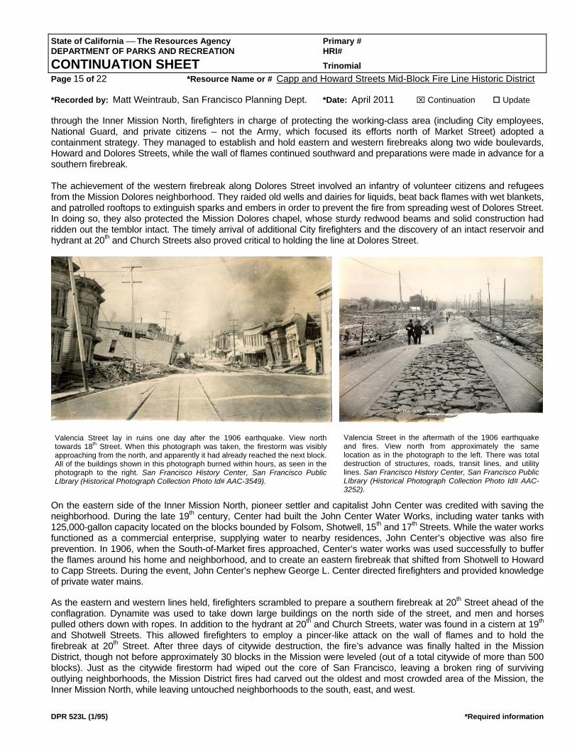
Valencia Street lay in ruins one day after the 1906 earthquake. View north towards 18th Street. When this photograph was taken, the firestorm was visibly approaching from the north, and apparently it had already reached the next block. All of the buildings shown in this photograph burned within hours, as seen in the photograph to the right. San Francisco History Center, San Francisco Public LIbrary (Historical Photograph Collection Photo Id# AAC-3549).
Valencia Street in the aftermath of the 1906 earthquake and fires. View north from approximately the same location as in the photograph to the left. There was total destruction of structures, roads, transit lines, and utility lines. San Francisco History Center, San Francisco Public LIbrary (Historical Photograph Collection Photo Id# AAC-3252).

State of California ⎯ The Resources Agency Primary # DEPARTMENT OF PARKS AND RECREATION HRI# CONTINUATION SHEET Trinomial Page 16 of 22 *Resource Name or # Capp and Howard Streets Mid-Block Fire Line Historic District *Recorded by: Matt Weintraub, San Francisco Planning Dept. *Date: April 2011 ⌧ Continuation Update
DPR 523L (1/95) *Required information
Rebuilding and Up-building The rebuilding of San Francisco in the aftermath of the 1906 earthquake and fires was unprecedented in scope and effort. Rebuilding required clearing of approximately four square miles of absolutely devastated urban landscape (involving temporary installation of debris-carrying rail-cars through city neighborhoods), repair of broken utilities, transit lines, and roads, and total replacement of burned structures and neighborhoods. All of this was accomplished and more, without central plan or control, by private citizens, businesses, and city government. In The Earth Shook, the Sky Burned, Bronson celebrated the physical reconstruction of the city as a victory for character, efficiency, and technology:
“And the job was not only done, but it was done faster and better than anyone thought possible. In three years, almost all of the burned area was rebuilt… In 1909, more than half of America’s steel and concrete buildings stood in San Francisco. In three years, the assessed valuation of the City was half again as much as it had been before the fire. Twenty thousand buildings – bigger, stronger, more modern than the 28,000 which went up in smoke – had been finished in that space and time.” (Pages 178-179)
In the burned area of the Inner Mission North, at least 600 buildings were constructed from the summer of 1906 through 1908, which was the peak of rebuilding activity citywide. From 1909 until the beginning of World War I, as building activity gradually tapered off, another 400 or so buildings were erected in the neighborhood. Complete reconstruction of the Inner Mission North took longer than for that of downtown and its nearby residential neighborhoods, due in part to politics and business, which dictated that restoration of the downtown core was highest priority. Also, working-class and/or immigrant citizens experienced difficulties and delays in obtaining insurance claims. In many cases, insurance pay-outs ultimately could not cover costs of rebuilding and owners were forced to sell their properties to speculators and commercial builders. A decade after the fire swept through the neighborhood, there remained more undeveloped and underutilized land in the Inner Mission North than there had been before the fire. The physical rebuilding of San Francisco and the Inner Mission North involved “upbuilding,” a process of constructing larger structures with more units to replace those that had been destroyed. The upbuilding of the Mission was related to a lucrative rental market for permanent housing following the disaster, which prompted rebuilding at higher density. Post-fire residential buildings were taller, bulkier, and covered more of their lots so that front and side yards were reduced or eliminated. In the Inner Mission North, where
single-family dwellings and two-family flats had dominated the formerly suburban neighborhood before the fires, the post-
Map of San Francisco by R.J. Waters & Co. (1906), showing the vast area (shaded) that was destroyed by the firestorm of 1906, and that was reconstructed in phases during the years and decades that followed. The outlined area indicates the northern portion of the Mission District that was destroyed by fires and that was rebuilt.
State of California ⎯ The Resources Agency Primary # DEPARTMENT OF PARKS AND RECREATION HRI# CONTINUATION SHEET Trinomial Page 17 of 22 *Resource Name or # Capp and Howard Streets Mid-Block Fire Line Historic District *Recorded by: Matt Weintraub, San Francisco Planning Dept. *Date: April 2011 ⌧ Continuation Update
DPR 523L (1/95) *Required information
fire upbuilding resulted in a mostly three to six-unit housing stock, built cheek-to-jowl and forming solid blocks of urban streetscape. Overall, the upbuilding and the greater population density of the Inner Mission North changed the neighborhood character from suburban to urban, as indicated by Godfrey in Neighborhoods in Transition: “The housing shortage in the city encouraged the development of increased densities in the Mission…[V]acant lots were developed, often with higher-density flats and apartment buildings, to house refugees from ravaged areas…This lowered the social standing of the district, making it a more strictly working-class area.” (Page 146) In the first year or so after the disaster, while building materials, labor, and capital were scarce, many owner-builders endeavored to construct small, plain single-family cottages just large enough to provide basic shelter. These small vernacular dwellings were usually intended as temporary housing solutions; many were replaced with larger residential buildings within a few years, while others were retained at the backs of lots and multiple-family housing was constructed in front. More rarely, some property owners in the Inner Mission North bucked the trend of upbuilding and rebuilt permanent, full-size single-family houses, some of them architect-designed, rather than convert their land to rental housing.
While post-fire buildings were essentially larger, more crowded versions of the wood boxes that had been built for decades, their façades revealed clear shifts in architectural tastes that occurred around the turn of the century. Post-fire row-house construction uniformly incorporated Beaux-Arts-influenced architecture that emphasized formal classicism over the riotous decoration and textures of the late Victorian era. Post-Victorian-era architecture was described by Alexander and Heig in San Francisco: Building the Dream City:
“Generally referred to today as ‘Edwardian,’ these buildings loosely followed the Roman Revival Style popular in the city just before 1906. Completely of frame construction, their first floors are generally given a veneer of yellow or Roman brick. The finer examples have a columned entrance, sometimes with marble steps and paneling, and perhaps leaded, beveled glass in the front door and side panels. Above the first floor are rows of curved bay windows whose large glass panes are also curvilinear, especially at corners. The heavy roof lines are turned out with modillions and cornices, and any stray door or window handsomely ornamented with pilasters and consoles, in the approved Roman Revival style.” (Page 362)
In addition to these more fully developed examples of Edwardian-era architecture, plainer and less expensive versions were built in the Mission. Workingman’s Edwardians featured slanted bay windows rather than curved; cast stone bases rather than brick; simple cornice details such as “block” modillions; and fewer façade details. Waldhorn and Woodbridge’s Victoria’s Legacy provided this alternate description of similar building stock:
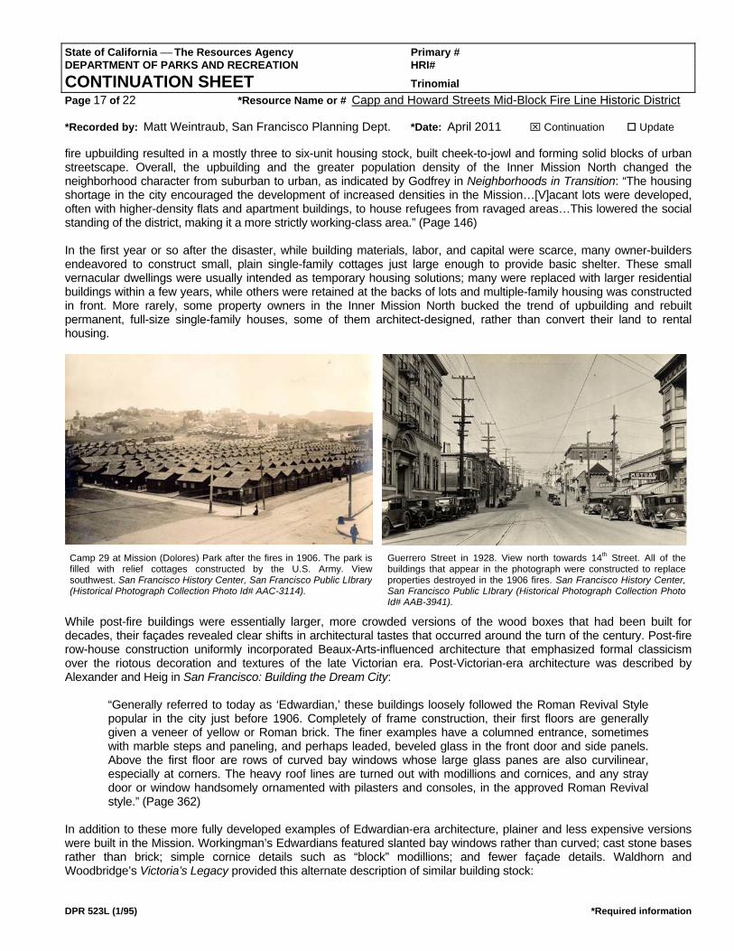
Camp 29 at Mission (Dolores) Park after the fires in 1906. The park isfilled with relief cottages constructed by the U.S. Army. View southwest. San Francisco History Center, San Francisco Public LIbrary (Historical Photograph Collection Photo Id# AAC-3114).
Guerrero Street in 1928. View north towards 14th Street. All of the buildings that appear in the photograph were constructed to replace properties destroyed in the 1906 fires. San Francisco History Center, San Francisco Public LIbrary (Historical Photograph Collection Photo Id# AAB-3941).
State of California ⎯ The Resources Agency Primary # DEPARTMENT OF PARKS AND RECREATION HRI# CONTINUATION SHEET Trinomial Page 18 of 22 *Resource Name or # Capp and Howard Streets Mid-Block Fire Line Historic District *Recorded by: Matt Weintraub, San Francisco Planning Dept. *Date: April 2011 ⌧ Continuation Update
DPR 523L (1/95) *Required information
“Edwardian buildings are two to three stories high with flat roofs and shallow cornices made up of small, flat brackets with rows of molding underneath, usually dentils and egg and dart. The bay windows are the three-sided slanted variety, although buildings on corner lots often have a rounded corner bay. Some Edwardians have exterior stairs forming a series of balconies in the center of the front of the building; apartments in this type of Edwardian were called “Romeo” or “Romeo and Juliet” apartments because of the balconies…” (Page 205)
Within the fire zone, the massive reconstruction effort over a short period of time generated swaths of remarkably consistent, early 20th-century architecture. Stylistic variations occurred, though standard façade layouts and building plans dominated. In addition to Roman Revival-derived architectural styles, other popular styles included: Mission Revival, which substituted classical features for Spanish tile accents and bell-shaped parapets; Craftsman with clinker-brick bases, boxy window bays, and bracketed eaves; and later Queen Anne, which was classically-influenced and featured ornament that was toned down from late 19th-century versions. Some builders expanded the Edwardian-era lexicon by artfully combining features of different styles such as Craftsman and Mission Revival, or Classical Revival with Moorish influence.
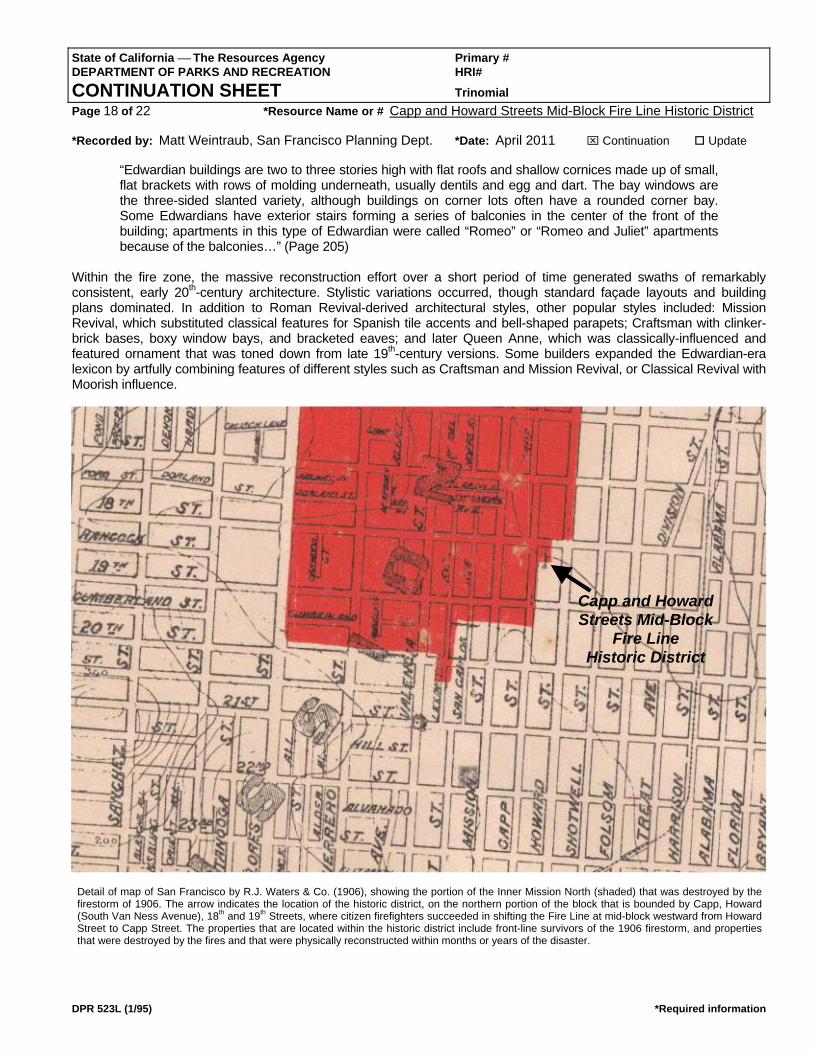
Capp and Howard Streets Mid-Block
Fire Line Historic District
Detail of map of San Francisco by R.J. Waters & Co. (1906), showing the portion of the Inner Mission North (shaded) that was destroyed by the firestorm of 1906. The arrow indicates the location of the historic district, on the northern portion of the block that is bounded by Capp, Howard (South Van Ness Avenue), 18th and 19th Streets, where citizen firefighters succeeded in shifting the Fire Line at mid-block westward from Howard Street to Capp Street. The properties that are located within the historic district include front-line survivors of the 1906 firestorm, and properties that were destroyed by the fires and that were physically reconstructed within months or years of the disaster.
State of California ⎯ The Resources Agency Primary # DEPARTMENT OF PARKS AND RECREATION HRI# CONTINUATION SHEET Trinomial Page 19 of 22 *Resource Name or # Capp and Howard Streets Mid-Block Fire Line Historic District *Recorded by: Matt Weintraub, San Francisco Planning Dept. *Date: April 2011 ⌧ Continuation Update
DPR 523L (1/95) *Required information
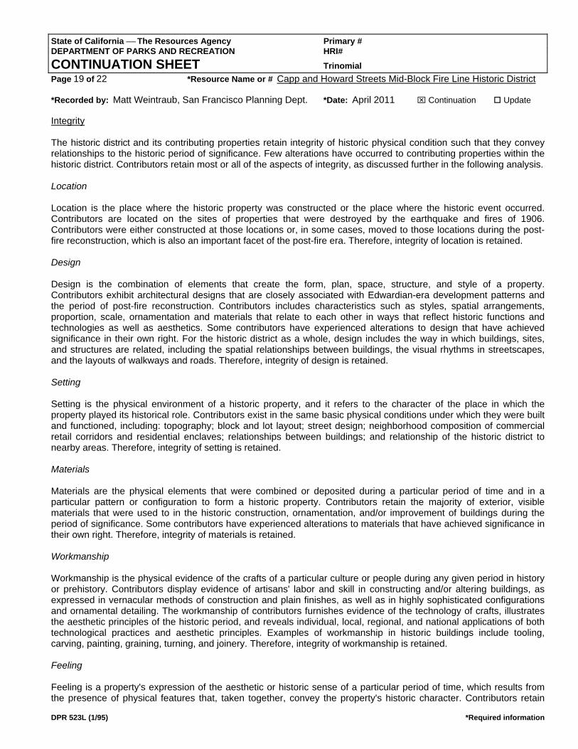
Integrity The historic district and its contributing properties retain integrity of historic physical condition such that they convey relationships to the historic period of significance. Few alterations have occurred to contributing properties within the historic district. Contributors retain most or all of the aspects of integrity, as discussed further in the following analysis. Location Location is the place where the historic property was constructed or the place where the historic event occurred. Contributors are located on the sites of properties that were destroyed by the earthquake and fires of 1906. Contributors were either constructed at those locations or, in some cases, moved to those locations during the post-fire reconstruction, which is also an important facet of the post-fire era. Therefore, integrity of location is retained. Design Design is the combination of elements that create the form, plan, space, structure, and style of a property. Contributors exhibit architectural designs that are closely associated with Edwardian-era development patterns and the period of post-fire reconstruction. Contributors includes characteristics such as styles, spatial arrangements, proportion, scale, ornamentation and materials that relate to each other in ways that reflect historic functions and technologies as well as aesthetics. Some contributors have experienced alterations to design that have achieved significance in their own right. For the historic district as a whole, design includes the way in which buildings, sites, and structures are related, including the spatial relationships between buildings, the visual rhythms in streetscapes, and the layouts of walkways and roads. Therefore, integrity of design is retained. Setting Setting is the physical environment of a historic property, and it refers to the character of the place in which the property played its historical role. Contributors exist in the same basic physical conditions under which they were built and functioned, including: topography; block and lot layout; street design; neighborhood composition of commercial retail corridors and residential enclaves; relationships between buildings; and relationship of the historic district to nearby areas. Therefore, integrity of setting is retained. Materials Materials are the physical elements that were combined or deposited during a particular period of time and in a particular pattern or configuration to form a historic property. Contributors retain the majority of exterior, visible materials that were used to in the historic construction, ornamentation, and/or improvement of buildings during the period of significance. Some contributors have experienced alterations to materials that have achieved significance in their own right. Therefore, integrity of materials is retained. Workmanship Workmanship is the physical evidence of the crafts of a particular culture or people during any given period in history or prehistory. Contributors display evidence of artisans' labor and skill in constructing and/or altering buildings, as expressed in vernacular methods of construction and plain finishes, as well as in highly sophisticated configurations and ornamental detailing. The workmanship of contributors furnishes evidence of the technology of crafts, illustrates the aesthetic principles of the historic period, and reveals individual, local, regional, and national applications of both technological practices and aesthetic principles. Examples of workmanship in historic buildings include tooling, carving, painting, graining, turning, and joinery. Therefore, integrity of workmanship is retained. Feeling Feeling is a property's expression of the aesthetic or historic sense of a particular period of time, which results from the presence of physical features that, taken together, convey the property's historic character. Contributors retain

State of California ⎯ The Resources Agency Primary # DEPARTMENT OF PARKS AND RECREATION HRI# CONTINUATION SHEET Trinomial Page 20 of 22 *Resource Name or # Capp and Howard Streets Mid-Block Fire Line Historic District *Recorded by: Matt Weintraub, San Francisco Planning Dept. *Date: April 2011 ⌧ Continuation Update
DPR 523L (1/95) *Required information
historic design, materials, workmanship, and setting that cumulatively relate the feeling of the early 20th century. Therefore, integrity of feeling is retained. Association Association is the direct link between an important historic event or person and a historic property. Contributors retains association by virtue of being located in the place where the significant historic events and activities of post-fire reconstruction occurred, and by virtue of being sufficiently intact to convey that relationship to an observer. Therefore, integrity of association is retained.

State of California ⎯ The Resources Agency Primary # DEPARTMENT OF PARKS AND RECREATION HRI# CONTINUATION SHEET Trinomial Page 21 of 22 *Resource Name or # Capp and Howard Streets Mid-Block Fire Line Historic District *Recorded by: Matt Weintraub, San Francisco Planning Dept. *Date: April 2011 ⌧ Continuation Update
DPR 523L (1/95) *Required information
*D7. References: (Continued from Page 1) Alexander, James Beach and James Lee Haig. San Francisco: Building the Dream City. San Francisco: Scottwall Associates, 2002. Bronson, William. The Earth Shook, the Sky Burned. San Francisco: Chronicle Books, 1959 (republished 2006). “‘Father of Mission,’ John Center, Dies,” San Francisco Call, 20 July 1908, 1. Fradkin, Philip L. The Great Earthquake and Firestorms of 1906: How San Francisco Nearly Destroyed Itself. Berkeley: University of California Press, 2005. “George L. Center to Race for Mayoralty,” San Francisco Call, 17 June 1909. Godfrey, Brian J. Neighborhoods in Transition: The Making of San Francisco’s Ethnic and Nonconformist Communities. Berkeley: University of California Press, 1988. Groth, Paul. Ordinary Storefronts of the Twentieth Century: Articulating the Lines between Shoppers and Retailers. 2005. Unpublished draft. Courtesy of the author. Hansen, Gladys and Emmet Condon. Denial of Disaster. San Francisco: Cameron and Company, 1989. Hooper, Bernadette C. San Francisco’s Mission District. Charleston, South Carolina: Arcadia Publishing, 2006. Issel, William and Robert W. Cherny. San Francisco, 1865-1932: Politics, Power, and Urban Development. Berkeley: University of California Press, 1986. Junior League of San Francisco. Here Today: San Francisco’s Architectural Heritage. San Francisco: Chronicle Books, 1968. Kennedy, John Castillo. The Great Earthquake and Fire: San Francisco, 1906. New York: William Morrow and Company, 1963. Lewis, Oscar. San Francisco: Mission to Metropolis. Berkeley: Howell-North Books, 1966. “Lookups & Directories Online.” http://freepages.genealogy.rootsweb.ancestry.com/~npmelton/sfc.html (accessed February-March 2011). [San Francisco City Directories, 1850-1982.] McAlester, Virginia and Lee McAlester. A Field Guide to American Houses. New York: Alfred A. Knopf, 2005. Mission Dolores Neighborhood Association. “Historic Context,” in Revised Mission Dolores Neighborhood Survey. San Francisco: 2009. Moudon, Anne Vernez. Built for Change: Neighborhood Architecture in San Francisco. Cambridge: MIT Press, 1986. Poppeliers, John C. and S. Allen Chambers, Jr. What Style Is It? A Guide to American Architecture. New York: John Wiley & Sons, 2003. “Rich Realty Broker Dies,” San Francisco Examiner, 13 September 1923, 8. Rifkind, Carole. A Field Guide to American Architecture. New York: New American Library, 1980. San Francisco Department of Building Inspection (DBI). Historic permit files (various) located at the DBI Records, 1660 Mission Street, 4th Floor, San Francisco, California 9103.

State of California ⎯ The Resources Agency Primary # DEPARTMENT OF PARKS AND RECREATION HRI# CONTINUATION SHEET Trinomial Page 22 of 22 *Resource Name or # Capp and Howard Streets Mid-Block Fire Line Historic District *Recorded by: Matt Weintraub, San Francisco Planning Dept. *Date: April 2011 ⌧ Continuation Update
DPR 523L (1/95) *Required information
San Francisco Planning Department. City within a City: Historic Context Statement for San Francisco’s Mission District. 2007. San Francisco Planning Department. Historic Neighborhoods of the Mission District, San Francisco, California. National Register of Historic Places Multiple Property Documentation Form (NPS Form 10-900-b). 2010. San Francisco Planning Department. Historic property files (various) located at 1650 Mission Street, Suite 400, San Francisco, California 94103. San Francisco Planning Department. Inner Mission North 1853-1943 Context Statement, 2005. 2005. Sanborn Map & Publishing Co. Insurance Maps of San Francisco, California. New York: 1886-1893; 1899-1900; 1913-1915; 1913-1915 (corrected to 1950); 1913-1915 (corrected to 1998). Scott, Mel. The San Francisco Bay Area: A Metropolis in Perspective. Berkeley: University of California Press, 1959. Smith, Dennis. San Francisco is Burning: The Untold Story of the 1906 Earthquake and Fires. New York: Plume (Penguin), 2005. Waldhorn, Judith Lynch and Sally B. Woodbridge. Victoria’s Legacy: Tours of San Francisco Bay Area Architecture. San Francisco: 101 Productions, 1978. Wollenberg, Charles. Golden Gate Metropolis: Perspectives on Bay Area History. Berkeley: Institute of Governmental Studies, University of California: 1985. Woodbridge, Sally (ed.). Bay Area Houses. New York: Oxford University Press, 1976. Wright, Gwendolyn. Building the Dream: A Social History of Housing in America. Cambridge: The MIT Press, 1981. Young, John P. San Francisco: A History of the Pacific Coast Metropolis. The S.J. Clarke Publishing Company: San Francisco, 1912. http://www.archive.org/stream/sanfranciscohist01youn#page/n11/mode/2up (accessed October 13, 2010).