Embed Size (px)
Citation preview

State of Alaska v. United States of America, et al. Page 1 of 81 Complaint
MICHAEL C. GERAGHTY ATTORNEY GENERAL Z. Kent Sullivan (Alaska Bar No. 0105038) R. Poke Haffner (Alaska Bar No. 8106025) Assistant Attorneys General Department of Law P.O. Box 110300 Juneau, Alaska 99811-0300 Telephone: (907) 465-3600 Facsimile: (907) 465-2539 Email: [email protected] [email protected] Attorneys for State of Alaska
IN THE UNITED STATES DISTRICT COURT FOR THE DISTRICT OF ALASKA
STATE OF ALASKA DEPARTMENT OF NATURAL REOURCES and DEPARTMENT OF TRANSPORTATION AND PUBLIC FACILITIES,
Plaintiffs,
v.
UNITED STATES OF AMERICA; AGNES M. PURDY, Owner of Native Allotment No. 50-2008-0437 (certificate no.); that portion of Native Allotment No. 50-2008-0437 currently occupied by the Chicken Ridge Alternate, Myers Fork Spur, Chicken to Franklin and Chicken Ridge Trails, and containing approximately 17.5 acres of land; BARBARA A. REDMON, on behalf of Anne L. Purdy, Owner of Native Allotment No. 50-2013-0004 (certificate no.); that portion of Native Allotment No. 50-2013-0004 currently occupied by the Chicken to Franklin and Chicken Ridge Trails, and containing approximately 6.4 acres of land;
) ) ) ) ) ) ) ) ) ) ) ) ) ) ) ) ) ) ) ) ) ) ) ) )
Case No.: COMPLAINT
Case 4:13-cv-00008-RRB Document 1 Filed 03/20/13 Page 1 of 81

State of Alaska v. United States of America, et al. Page 2 of 81 Complaint
DENA’ NENA’ HENASH, a/k/a Tanana Chiefs Conference, an Alaska non-profit corporation; GEORGE W. SEUFFERT, SR.; CHICKEN VENTURES, LLC, an Alaska limited liability company; GEORGE W. SEUFFERT, JR.; BRONK G. JORGENSEN; THOR D. JORGENSEN; MICHAEL R. BUSBY; ANTON J. HANAK; MILLROCK ALASKA, LLC, an Alaska limited liability company; CHARLES R. HAMMOND; ALASKA EARTH RESOURCES, INC., an Alaska corporation; WILLIAM M. MASSENGALE; FRANCES E. MASSENGALE; MASTODON MINING, LLC, an Alaska limited liability company, MARK S. BREECE; SHELDON F. MAIER; JANNE H. MAIER; SILVER J. STROER; EVA L. STROER; TYE R. KIRSCH; DWAIN L. GIBSON; DAVID N. DONALD; TERRI CASE; RICK H. DOBBELAERE; WILLIAM H. BAYLESS; SIEGLINDE U. DAACK; FORTYMILE MINING DISTRICT, a/k/a Forty Mile Mining Association, an Alaska non-profit corporation; and other persons unknown, claiming or who might claim any right, title, estate or interest in or lien or encumbrance upon, the real property described in the Complaint, or any part thereof, adverse to Plaintiff’s ownership, or any cloud upon Plaintiff’s title thereto, whether such claim or possible claim be present or contingent,
Defendants. ___________________________________
) ) ) ) ) ) ) ) ) ) ) ) ) ) ) ) ) ) ) ) ) ) ) ) ) ) ) ) ) ) ) ) ) ) ) ) )
The State of Alaska for its complaint against the above-named Defendants alleges
as follows:
Case 4:13-cv-00008-RRB Document 1 Filed 03/20/13 Page 2 of 81
State of Alaska v. United States of America, et al. Page 3 of 81 Complaint
INTRODUCTION
1. This action is brought by the State for the purpose of, among other things,
quieting title to the State’s ownership interests in certain public rights-of-way (as
referenced herein, the terms “rights-of-way” or “right-of-way” are intended as
synonymous with the term “easement”) located in Alaska’s Fortymile Region (named
after the Fortymile River which is the area’s primary watershed) near Chicken, Alaska.
A map generally depicting the location of the rights-of-way is attached as Exhibit “1.”
2. The roads and trails at issue in this litigation are public rights-of-way
granted by the United States pursuant to the Act of July 26, 1866, ch. 262, §8, 14 Stat.
251, 253, which was later codified as Revised Statute 2477, subsequently recodified as
43 U.S.C. §932 (repealed October 21, 1976 with a savings provision recognizing the
validity of rights-of-way already established), hereafter referred to as “R.S. 2477.”
3. Historically, there has been a lack of certainty regarding Defendants’
recognition of the State of Alaska’s ownership interests in the rights-of-way. At times,
the State and Defendant United States have claimed variously conflicting interests. The
same has also been true as between the State and some of the non-federal Defendants.
This lack of certainty has created clouds on the State’s title and has further caused
uncertainty regarding the ownership, use, management, and control of the rights-of-way.
JURISDICTION & VENUE
4. The State brings this action pursuant to:
A. the Quiet Title Act (“QTA”), 28 U.S.C. §2409a, which authorizes a
federal district court to adjudicate disputes over the title to real
property in which the United States claims an interest;
B. the Declaratory Judgment Act, 28 U.S.C. §2201, which authorizes a
federal district court in a case or controversy to declare the rights
and legal relations of an interested party seeking such a declaration;
C. 28 U.S.C. §1367(a), authorizing a federal district court to consider
pendent state law claims. In this action, the pendent state law claims
are to quiet title pursuant to Alaska Statute 09.45.010 and to regain
Case 4:13-cv-00008-RRB Document 1 Filed 03/20/13 Page 3 of 81

State of Alaska v. United States of America, et al. Page 4 of 81 Complaint
possession of a real property interest pursuant to Alaska Statute
09.45.630; and
D. 25 U.S.C. §357 authorizing the condemnation of lands allotted to
Indians pursuant to State laws.
5. The Court has jurisdiction over this action pursuant to 28 U.S.C. §§1331,
1346(f), 28 U.S.C. §2201–02, 28 U.S.C. §1367(a), and 25 U.S.C. §357.
6. This Court also has jurisdiction over this action because the QTA waives
sovereign immunity of the federal government to resolve disputes over the title to real
property in which the United States claims an interest.
7. The State has satisfied the QTA’s 180-day notice of intent to sue
requirement as set forth in 28 U.S.C. §2409a(m).
8. By letters dated December 13, 1993, March 11, 2011, and April 5, 2012,
the Office of the Attorney General for the State of Alaska gave notice to the U.S.
Department of the Interior (“DOI”) of its intent to file suit with regard to the ownership
interests in the roads and trails at issue in this case.
9. This is an action brought by a state and is timely under 28 U.S.C.
§2409a(g).
10. 28 U.S.C. §1346(f) provides that federal district courts have exclusive
original jurisdiction over civil actions arising under the QTA.
11. This Court further has QTA jurisdiction over the lands at issue herein
pursuant to State of Alaska v. Babbitt, 182 F.3d 672 (9th Cir. 1999) because there exists
no colorable basis for application of the Indian Lands exception to the QTA’s waiver of
sovereign immunity.
12. Venue is proper in this Court under 28 U.S.C. §1391(e) and 28 U.S.C.
§81A because the lands at issue in this lawsuit are located within the District of Alaska.
13. A case or controversy has arisen over the State’s ownership interests in the
lands described herein and its jurisdiction to regulate and control this land.
Case 4:13-cv-00008-RRB Document 1 Filed 03/20/13 Page 4 of 81

State of Alaska v. United States of America, et al. Page 5 of 81 Complaint
PARTIES
14. Plaintiff State of Alaska, through its administrative agencies the
Department of Natural Resources and the Department of Transportation and Public
Facilities, is a sovereign state of the United States. The State owns highway rights-of-
way granted by the United States pursuant to R.S. 2477. In bringing this lawsuit, the
State of Alaska seeks to confirm and retain its right to manage its lands and to prevent
and remediate the attendant harm to it and its citizens by being deprived of this right.
15. Defendant United States of America is a sovereign nation and holds title to
portions of the servient real property (burdened by the right-of-way or easement)
traversed by some of the rights-of-way that are the subject of this action. Defendant
United States also holds restrictions on alienation for Alaska Native allotments, two of
which are at issue in this case as further set forth below.
16. Defendant Agnes M. Purdy is an individual residing in Fairbanks, Alaska.
17. Any legal interest of Defendant Agnes M. Purdy in and to the property at
issue in this case derives from:
A. Native Allotment Certificate Number 50-2008-0437, naming the
United States of America as Grantor and the heirs, devisees and/or
assigns of Arthur Purdy, Sr., as Grantee, dated August 11, 2008, and
recorded at Serial No. 2008-018384-0, records of the Fairbanks
Recording District, Fourth Judicial District, State of Alaska.
B. A document entitled “Decision” in probate P000073132IP, issued by
the U. S. Department of the Interior Office of Hearings and Appeals
in the matter of the Estate of Arthur Harold Purdy, Sr., on September
10, 2009, and recorded at Serial No. 2009-021588-0, records of the
Fairbanks Recording District, Fourth Judicial District, State of
Alaska. The above-referenced decision transferred all right, title and
interest to Native Allotment No. 50-2008-0437 to Agnes M. Purdy.
Case 4:13-cv-00008-RRB Document 1 Filed 03/20/13 Page 5 of 81

State of Alaska v. United States of America, et al. Page 6 of 81 Complaint
18. Defendant Barbara A. Redmon, an individual residing in Chugiak, Alaska,
has been appointed legal guardian of Anne L. Purdy, an individual residing in Palmer,
Alaska.
19. Any legal interest of Defendant Anne L. Purdy in and to the property at
issue in this case derives from Native Allotment Certificate Number 50-2013-0004,
naming the United States of America as Grantor and Anne L. Purdy, in care of Barbara
A. Redmon, as Grantee, dated October 4, 2012, and recorded at Serial No. 2012-021825-
0, records of the Fairbanks Recording District, Fourth Judicial District, State of Alaska.
20. Defendant Dena’ Nena’ Henash, a/k/a Tanana Chiefs Conference (“TCC”),
is an Alaska non-profit corporation with its principal place of business in Fairbanks,
Alaska.
21. Defendant TCC is named in this case based upon its actions in seeking to
discourage and deny the public’s right of access over the two Native allotments
referenced above. Defendant TCC has done so by posting portions of the public right-of-
way at issue herein with “No Trespassing” signs and by initiating litigation against
members of the public seeking to use these rights-of-way.
22. Defendant George W. Seuffert, Sr. is an individual residing in Chicken,
Alaska.
23. Defendant Chicken Ventures, LLC, is an Alaska limited liability company
with its principal place of business located in Chicken, Alaska.
24. At various times, Defendants Seuffert, Sr., and Chicken Ventures, LLC,
have asserted ownership interests in some or all of the mining claims and property
interests set forth below. Any legal interests of Defendants in and to the property at issue
in this case derive from:
A. a patented placer mining claim known as 7 Below Right Limit
Bench, U.S. Mineral Survey No. 2177, being more particularly
described in that certain Patent from the United States of America,
Patent No. 1150079, dated February 25, 1955, recorded March 10,
Case 4:13-cv-00008-RRB Document 1 Filed 03/20/13 Page 6 of 81

State of Alaska v. United States of America, et al. Page 7 of 81 Complaint
1955 in Book 72 at Page 164, Records of the Fairbanks Recording
District, Fourth Judicial District, State of Alaska;
B. those patented placer mining claims known as No. 3 Below
Discovery, No. 4 Below Discovery and No. 5 Below Discovery,
U.S. Mineral Survey No. 2095, being more particularly described in
that certain Patent from the United States of America, Patent No.
1116514, dated March 26, 1943, within Sections 29 and 32, T. 27
N., R. 18 E., Copper River Meridian, Records of the Fairbanks
Recording District, Fourth Judicial District, State of Alaska;
C. the land embraced within No. 1 Claim on Myers Fork, U.S. Mineral
Survey No. 2178, recorded on an unknown date in 1955 in Book 72
at Page 190, Records of the Fairbanks Recording District, Fourth
Judicial District, Fairbanks, Alaska;
D. those patented placer mining claims known as Larson Bench, No. 6
Below Discovery, Black Bottom, Yellow Jacket Bench Claim, and
5½ Below Discovery, U.S. Mineral Survey No. 2096, being more
particularly described in that certain Patent from the United States of
America, Patent No. 1118396, dated May 3, 1944, recorded in Book
32 at Page 279, within Section 32, T. 27 N., R. 18 E., Copper River
Meridian, Records of the Fairbanks Recording District, Fourth
Judicial District, State of Alaska;
E. those patented placer mining claims known as Agnes Bench and No.
9 Below Discovery, being a portion of U.S. Mineral Survey No.
2097, being more particularly described in that certain Patent from
the United States of America, Patent No. 1118395, dated May 3,
1944, recorded in Book 32 at Page 282, Records of the Fairbanks
Recording District, Fourth Judicial District, State of Alaska;
F. A deed for various patented mining claims in Chicken Creek naming
Alaska Gold Company as Grantor and George Seuffert as Grantee,
Case 4:13-cv-00008-RRB Document 1 Filed 03/20/13 Page 7 of 81

State of Alaska v. United States of America, et al. Page 8 of 81 Complaint
dated March 6, 1998, recorded March 13, 1998, in Book 1054 at
Page 455, Records of the Fairbanks Recording District, Fourth
Judicial District, State of Alaska;
G. A quit claim deed for various patented mining claims in Chicken
Creek naming George W. Seuffert as Grantor and Chicken Ventures,
LLC as Grantee, recorded November 21, 2005, at Serial Number
2005-025914-0, Records of the Fairbanks Recording District, Fourth
Judicial District, State of Alaska; and
H. State mining claim numbers:
1. ADL 577255 9. ADL 577267
2. ADL 577256 10. ADL 577268
3. ADL 577257 11. ADL 577269
4. ADL 577258 12. ADL 640827
5. ADL 577261 13. ADL 640828
6. ADL 577262 14. ADL 640830
7. ADL 577265 15. ADL 640831
8. ADL 577266 16. ADL 672109
such claims being located in Sections 18, 19, 29, 30, 31 and 32, T. 27 N., R. 18 E.,
Copper River Meridian, State of Alaska.
25. Defendant George W. Seuffert, Jr., is an individual residing in Fairbanks,
Alaska.
26. Any legal interests of Defendant George W. Seuffert, Jr., in and to the
property at issue in this case derive from State mining claim numbers:
A. ADL 603331 D. ADL 640828
B. ADL 640831 E. ADL 640827
C. ADL 640830 F. ADL 640829
such claims being located in Sections 18 and 29, T. 27 N., R. 18 E., Copper River
Meridian, State of Alaska.
27. Defendant Bronk G. Jorgensen is an individual residing in Tok, Alaska.
Case 4:13-cv-00008-RRB Document 1 Filed 03/20/13 Page 8 of 81

State of Alaska v. United States of America, et al. Page 9 of 81 Complaint
28. Any legal interests of Defendant Bronk Jorgensen in and to the property at
issue in this case derive from:
A. the patented placer mining claim known as French Fraction, U.S.
Mineral Survey No. 2096, being more particularly described in that
certain Patent from the United States of America, Patent No.
1118396, dated May 3, 1944, recorded May 23, 1944 in Book 32 at
Page 279, within Section 32, T. 27 N., R. 18 E., Copper River
Meridian, Records of the Fairbanks Recording District, Fourth
Judicial District, State of Alaska;
B. the patented placer mining claim known as 7 Below Association,
U.S. Mineral Survey No. 2150, being more particularly described in
that certain Patent from the United States of America, Patent No.
1121072, dated July 31, 1946, within Section 32, T. 27 N., R. 18 E.,
Copper River Meridian, Records of the Fairbanks Recording
District, Fourth Judicial District, State of Alaska;
C. A statutory warranty deed for 7 Below Association, Chicken
Ventures, LLC as Grantor and Bronk Jorgensen as Grantee, dated
November 10, 2008, recorded December 3, 2008, at Serial Number
2008-023970-0, Records of the Fairbanks Recording District, Fourth
Judicial District, State of Alaska;
D. State mining claim number ADL 577254, such claim being located
in Sections 31 and 32, T. 27 N., R. 18 E., Copper River Meridian,
State of Alaska; and
E. Federal mining claim numbers:
1. FF 062055 4. FF 062058
2. FF 062056 5. FF 062059
3. FF 062057 6. FF 062060
such claims being located in Section 34, T. 28 N., R. 18 E., Copper River Meridian, State
of Alaska.
Case 4:13-cv-00008-RRB Document 1 Filed 03/20/13 Page 9 of 81

State of Alaska v. United States of America, et al. Page 10 of 81 Complaint
29. Defendant Thor D. Jorgensen is an individual residing in Tok, Alaska.
30. Any legal interests of Defendant Thor D. Jorgensen in and to the property
at issue in this case derive from federal mining claim number FF 062054, such claim
being located in Section 33, T. 28 N., R. 18 E., Copper River Meridian, State of Alaska.
31. Defendant Michael R. Busby is an individual residing in Chicken, Alaska.
32. Any legal interests of Defendant Busby in and to the property at issue in
this case derive from State mining claim numbers:
A. ADL 548025 G. ADL 658499
B. ADL 548026 H. ADL 658500
C. ADL 572612 I. ADL 658498
D. ADL 586781 J. ADL 665758
E. ADL 586783 K. ADL 665757
F. ADL 586784 L. ADL 706006
such claims being located in Sections 18, 19, 29 and 30, T. 27 N., R. 18 E., Copper River
Meridian, State of Alaska.
33. Defendant Anton J. Hanak is an individual residing in Anchorage, Alaska.
34. Any legal interests of Defendant Hanak in and to the property at issue in
this case derive from State mining claim numbers:
A. ADL 353235 F. ADL 361988
B. ADL 353236 G. ADL 361989
C. ADL 353237 H. ADL 361991
D. ADL 353240 I. ADL 361992
E. ADL 353241 J. ADL 361993
K. ADL 353238
such claims being located in Sections 20 and 29, T. 27 N., R. 18 E., Copper River
Meridian, State of Alaska.
35. Defendant Millrock Alaska, LLC, is an Alaska limited liability company
with its principal place of business located in Anchorage, Alaska.
Case 4:13-cv-00008-RRB Document 1 Filed 03/20/13 Page 10 of 81

State of Alaska v. United States of America, et al. Page 11 of 81 Complaint
36. Any legal interest of Defendant Millrock Alaska, LLC, in and to the
property at issue in this case derives from State mining claim number ADL 659257, such
claim being located in Section 29, T. 27 N., R. 18 E., Copper River Meridian, State of
Alaska.
37. Defendant Charles R. Hammond is an individual residing in Chicken,
Alaska.
38. Any legal interests of Defendant Hammond in and to the property at issue
in this case derive from State mining claim numbers:
A. ADL 553329 E. ADL 553732
B. ADL 553330 F. ADL 553735
C. ADL 553426 G. ADL 558167
D. ADL 553118 H. ADL 711537
such claims being located in Sections 17, 18 and 20, T. 27 N., R. 18 E., Copper River
Meridian, State of Alaska, and federal mining claim numbers:
I. FF 061745 K. FF 061749
J. FF 061748 L. FF 062065
such claims being located in Sections 20 and 29, T. 27 N., R. 18 E., Copper River
Meridian, State of Alaska.
39. Defendant Alaska Earth Resources, Inc., is an Alaska corporation with its
principal place of business in Anchorage, Alaska.
40. Any legal interests of Defendant Alaska Earth Resources, Inc., in and to the
property at issue in this case derive from State mining claim numbers:
A. ADL 702183 F. ADL 702188
B. ADL 702184 G. ADL 702192
C. ADL 702185 H. ADL 702198
D. ADL 702186 I. ADL 702208
E. ADL 702187
such claims being located in Sections 1, 2, 3, 5 and 12, T. 27 N., R. 17 E., Copper River
Meridian, State of Alaska; and
Case 4:13-cv-00008-RRB Document 1 Filed 03/20/13 Page 11 of 81

State of Alaska v. United States of America, et al. Page 12 of 81 Complaint
J. ADL 701644 S. ADL 701659
K. ADL 701645 T. ADL 701660
L. ADL 701646 U. ADL 701661
M. ADL 701651 V. ADL 701664
N. ADL 701652 W. ADL 701667
O. ADL 701653 X. ADL 701668
P. ADL 701654 Y. ADL 701669
Q. ADL 701655 Z. ADL 702776
R. ADL 701658
such claims being located in Sections 1, 2, 3,11, 12, 14, 15, 22, 23, T. 8 S., R. 27 E.,
Fairbanks Meridian, State of Alaska; and
AA. ADL 701665 CC. ADL 702774
BB. ADL 702769
such claims being located in Sections 34 and 35, T. 7 S., R. 27 E., Fairbanks Meridian,
State of Alaska; and
DD. ADL 702209 FF. ADL 702250
EE. ADL 702245
such claims being located in Sections 7 and 30, T. 27 N., R. 18 E., Copper River
Meridian, State of Alaska.
41. Defendant William M. Massengale is an individual residing in Anchorage,
Alaska.
42. Defendant Frances E. Massengale is an individual residing in Anchorage,
Alaska.
43. Defendant Mastodon Mining, LLC, is an Alaska limited liability company
with its principal place of business in Chicken, Alaska.
44. At various times, Defendants William and Frances Massengale and
Defendant Mastodon Mining, LLC, have all asserted ownership interests in some or all of
the mining claims set forth below. Any legal interests of these named Defendants in and
to the property at issue in this case derive from State mining claim numbers:
Case 4:13-cv-00008-RRB Document 1 Filed 03/20/13 Page 12 of 81

State of Alaska v. United States of America, et al. Page 13 of 81 Complaint
A. ADL 352571 D. ADL 359762
B. ADL 352572 E. ADL 359763
C. ADL 359761 F. ADL 352575
such claims being located in Sections 16, 20, 21 and 24, T. 27 N., R. 18 E., Copper River
Meridian, State of Alaska.
45. Defendant Mark S. Breece is an individual residing in Anchorage, Alaska.
46. Any legal interests of Defendant Breece in and to the property at issue in
this case derive from State mining claim numbers:
A. ADL 571209 B. ADL 571214
such claims being located in Sections 16 and 21, T. 27 N., R. 18 E., Copper River
Meridian, State of Alaska.
47. Defendant Sheldon F. Maier is an individual residing in Fairbanks, Alaska.
48. Defendant Janne H. Maier is an individual residing in Fairbanks, Alaska.
49. Any legal interests of Defendants Sheldon and Janne Maier in and to the
property at issue in this case derive from State mining claim numbers:
A. ADL 560963 E. ADL 560967
B. ADL 560964 F. ADL 606296
C. ADL 560965 G. ADL 606297
D. ADL 560966 H. ADL 606298
such claims being located in Sections 9, 10 and 11, T. 7 S., R. 27 E., Fairbanks Meridian,
State of Alaska.
50. Defendant Silver J. Stroer is an individual residing in Soldotna, Alaska.
51. Defendant Eva L. Stroer is an individual residing in Soldotna, Alaska.
52. Any legal interests of Defendants Silver and Eva Stroer in and to the
property at issue in this case derive from State mining claim numbers:
A. ADL 553111 B. ADL 661791
such claims being located in Sections 26 and 27, T. 7 S., R. 27 E., Fairbanks Meridian,
State of Alaska.
Case 4:13-cv-00008-RRB Document 1 Filed 03/20/13 Page 13 of 81

State of Alaska v. United States of America, et al. Page 14 of 81 Complaint
53. Defendant Tye R. Kirsch is an individual residing in Kenai, Alaska.
54. Any legal interests of Defendant Kirsch in and to the property at issue in
this case derive from State mining claim numbers:
A. ADL 704385 B. ADL 704386
such claims being located in Sections 26 and 27, T. 7 S., R. 27 E., Fairbanks Meridian,
State of Alaska.
55. Defendant Dwain L. Gibson is an individual residing in Soldotna, Alaska.
56. Defendant David N. Donald is an individual residing in Kenai, Alaska.
57. Any legal interests of Defendants Gibson and Donald in and to the property
at issue in this case derive from State mining claim number ADL 707199, such claim
being located in Section 26, T. 7 S., R. 27 E., Fairbanks Meridian, State of Alaska.
58. Defendant Terri Case is an individual residing in Las Vegas, Nevada.
59. Any legal interests of Defendant Case in and to the property at issue in this
case derive from State mining claim number ADL 641421, such claim being located in
Section 31, T. 28 N., R. 19 E., Copper River Meridian, State of Alaska and State mining
claim number ADL 641422, such claim being located in Sections 31, T. 28 N., R. 19 E.,
Copper River Meridian, State of Alaska.
60. Defendant Rick H. Dobbelaere is an individual residing in Oakwood, Ohio.
61. Any legal interests of Defendant Dobbelaere in and to the property at issue
in this case derive from State mining claim number ADL 668673, such claim being
located in Section 36, T. 28 N., Range 18 E., Copper River Meridian, State of Alaska and
Section 31, T. 28 N., R. 19 E., Copper River Meridian, State of Alaska.
62. Defendant William H. Bayless is an individual residing in Anchorage,
Alaska.
63. Any legal interests of Defendant Bayless in and to the property at issue in
this case derive from federal mining claim number FF 063481, such claim being located
in Section 31, T. 28 N., R. 19 E., Copper River Meridian, State of Alaska.
64. Defendant Sieglinde U. Daack is an individual residing in Portland,
Oregon.
Case 4:13-cv-00008-RRB Document 1 Filed 03/20/13 Page 14 of 81

State of Alaska v. United States of America, et al. Page 15 of 81 Complaint
65. Any legal interests of Defendant Daack in and to the property at issue in
this case derive from federal mining claim number FF 057213, such claim being located
in Section 31, T. 28 N., R. 18 E., Copper River Meridian, State of Alaska.
66. Defendant Fortymile Mining District, a/k/a Forty Mile Mining Association,
is an Alaska non-profit corporation with its principal place of business located in
Chicken, Alaska.
67. Any legal interests of Defendant Fortymile Mining District in and to the
property at issue in this case derive from
A. Tract A, Alaska State Land Survey No. 2004-31, according to the
plat filed September 24, 2010 as Plat No. 2010-97, Records of the
Fairbanks Recording District, Fourth Judicial District, State of
Alaska; and
B. a quit claim deed, naming the State of Alaska Department of Natural
Resources as Grantor and Fortymile Mining Association as Grantee,
dated February 24, 2011, and recorded at Serial No. 2011-003296-0,
records of the Fairbanks Recording District, Fourth Judicial District,
State of Alaska.
CONGRESSIONAL GRANT OF RIGHTS-OF-WAY FOR PUBLIC HIGHWAYS CROSSING PUBLIC LANDS
68. R.S. 2477 provided: “And be it further enacted, That [sic] the right of way
for the construction of highways over public lands, not reserved for public uses, is hereby
granted.”
69. R.S. 2477 was an open congressional grant of public rights-of-way for the
benefit of miners, ranchers, homesteaders and members of the public who had need to
travel across public lands.
70. Acceptance and vesting of an R.S. 2477 right-of-way required no
administrative formalities; no entry, no license, no patent, no deed on the federal side;
and no formal act of public acceptance on the part of the states or localities in whom the
right was vested.
Case 4:13-cv-00008-RRB Document 1 Filed 03/20/13 Page 15 of 81

State of Alaska v. United States of America, et al. Page 16 of 81 Complaint
71. A right of way under R.S. 2477 comes into existence automatically when a
public highway is established across public lands in accordance with the law of the state.
72. In the District Organic Act of May 17, 1884, ch. 53, §8, 23 Stat. 24,
Congress made R.S. 2477 applicable to the Territory of Alaska.
73. Alaska does not place a burdensome requirement on those claiming an
R.S. 2477 regarding the nature of the “highway.” AS 19.59.001(8) (and see 48 U.S.C
§321d (repealed 1959) for similar definition), defines a “highway” to include a “road,
street, trail, walk, bridge, tunnel, drainage structure and other similar or related structure
or facility, and right-of-way thereof.”
74. The rights-of-way at issue in this case are by definition “highways”
although they are not on the Alaska Highway System.
75. The R.S. 2477 grant by the federal government constituted a standing offer
of federal lands for the creation of public rights-of-way. Per Alaska law, the offer could
be accepted, prior to its repeal in 1976, by: a) public use for such a period of time and in
such a manner as to demonstrate acceptance of the grant; or b) by an action on the part of
appropriate public authorities clearly manifesting an intent to accept the grant of a right-
of-way.
76. A congressionally granted R.S. 2477 right-of-way is a valid existing
property right constituting a form of easement. As a congressional grant of property for
public purposes, such rights-of-way include the right to reasonably use, enjoy, and cross
public land.
77. The scope of an R.S. 2477 right-of-way includes the course and location of
the public highway so accepted, and that which is reasonably necessary under the specific
circumstances of the road or trail for which the right-of-way serves.
78. The scope of an R.S. 2477 right-of-way also includes the right to conduct
reasonable and necessary maintenance, repairs and improvements.
79. Reasonable and necessary maintenance includes, but is not limited to, the
following:
Case 4:13-cv-00008-RRB Document 1 Filed 03/20/13 Page 16 of 81

State of Alaska v. United States of America, et al. Page 17 of 81 Complaint
A. making minor deviations in the location of the right-of-way and/or
reasonably realigning it as may be necessary for safety purposes;
B. establishing and maintaining the road surface;
C. filling ruts and potholes;
D. leveling and smoothing washboards;
E. clearing the roadway of obstructing debris;
F. cleaning culverts, if any, including head basins and outlets;
G. resurfacing with the same or improved materials of the same general
type;
H. maintaining, repairing, replacing and installing rip rap;
I. maintaining drainage, including maintaining and repairing washouts,
wet areas, washes, and gullies;
J. repairing, replacing and installing culverts as necessary to protect the
existing road surface; and
K. reasonable relocation of the right-of-way as necessary due to
erosion, landslides, etc.
80. Performance of such maintenance helps to minimize degradation of the
servient estate by decreasing erosion, trail braiding and other impacts on adjacent lands.
81. The congressional grant of public highway rights-of-way embodied by
R.S. 2477 applied to unreserved public lands for 110 years until it was repealed in 1976
by the Federal Land Policy and Management Act (“FLPMA”), 43 U.S.C. §1701, et seq.
In repealing R.S. 2477, Congress preserved vested R.S. 2477 rights-of-way and expressly
directed the United States to manage federal lands subject to these valid existing rights.
82. FLPMA §701(a) provides:
“[n]othing in this Act, or in any amendment made by this Act, shall be construed as terminating any valid lease, permit, patent, right-of-way, or other land use right or authorization existing on the date of approval of this Act.”
83. FLPMA §701(h) provides:
Case 4:13-cv-00008-RRB Document 1 Filed 03/20/13 Page 17 of 81

State of Alaska v. United States of America, et al. Page 18 of 81 Complaint
“[a]ll actions by the Secretary concerned under this Act shall be subject to valid existing rights.”
84. FLPMA §509(a) provides:
“[n]othing in this title [43 U.S.C. §§1701-1784] shall have the effect of terminating any right-of-way or right to use heretofore issued, granted or permitted.”
85. The United States DOI has long agreed that state law governs the
acceptance and scope of R.S. 2477 rights-of-way.
86. In 1939, DOI adopted 43 C.F.R. §244.55 (1939). It provided:
“[R.S. 2477] becomes effective upon the construction or establishing of highways, in accordance with the State laws, over public lands not reserved for public uses. No application should be filed under said R.S. 2477 as no action on the part of the Federal Government is necessary.”
87. In 1963, the regulation was renumbered and modified slightly. 43 C.F.R.
§244.58 (1963) stated:
“Grants of [R.S. 2477 rights-of-way] become effective upon the construction or establishment of highways, in accordance with the State laws, over public lands, not reserved for public uses. No application should be filed under R.S. 2477, as no action on the part of the Government is necessary.”
88. In 1974, the regulation was again renumbered and slightly re-worded. 43
C.F.R. §2822.1-2 & 2822.2-1 (1974) stated:
“[n]o application should be filed under R.S. 2477, as no action on the part of the Government is necessary. . . . Grants of [R.S. 2477 rights-of-way] become effective upon the construction or establishment of highways, in accordance with the State laws, over public lands, not reserved for public uses.”
89. 43 C.F.R. §2822 was repealed in 1980 when the code underwent extensive
revisions after FLPMA was passed in 1976.
90. In 1986, the Bureau of Land Management (“BLM”) Manual, Section 2801,
Release 2-229, June 30, 1986, stated:
“[w]hen public funds have been spent on the road it shall be considered a public road. When the history of the road is unknown or questionable, its existence in a condition suitable for public use is
Case 4:13-cv-00008-RRB Document 1 Filed 03/20/13 Page 18 of 81

State of Alaska v. United States of America, et al. Page 19 of 81 Complaint
evidence that construction sufficient to cause a grant under R.S. 2477 has taken place.”
91. In 1994, the BLM proposed comprehensive regulations governing R.S.
2477 rights of way as referenced at 59 Fed. Reg. 39216, 39219-27 (1994). These rules
proposed administrative procedures for the BLM to adjudicate the validity of R.S. 2477
claims. Congress responded with an appropriations provision, U.S. Department of the
Interior and Related Agencies' Appropriations Act, 1997, §108, enacted by the Omnibus
Consolidated Appropriations Act, 1997, Pub. L. No. 104–208, 110 Stat. 3009 (1996),
prohibiting the DOI from issuing final rules governing R.S. 2477 rights-of-way.
92. BLM’s current policy regarding R.S. 2477s is contained in BLM Manual,
Section 2809. Section 2809.21(C) discusses BLM’s current perception regarding the
applicability of State law. It provides:
“While Federal law governs interpretation of R.S. 2477 in determining what is required for acceptance of a ROW under the statute, Federal law ‘borrows’ from long-established principles of state law, to the extent that state law provides convenient and appropriate principles for effectuating Congressional intent.”
93. This same BLM Manual, Section 2809.21(A)(6) further discusses the
BLM’s perceived ability to impose reasonable regulation on such rights-of-way:
Reasonable Regulations are those which do not: A. Impair rights the holder had under the pre-FLPMA law and
regulations in effect at the time of ROW grant, or B. Increase the holder’s liability for past conduct, or C. Impose new duties to transactions already completed. 94. R.S. 2477 case law and long-standing United States DOI interpretations
establish that the scope of the R.S. 2477 rights-of-way claimed by the State is that which
is reasonable and necessary to ensure the safe travel and passage of motor vehicles,
whether they are highway vehicles or off-highway vehicles (“OHVs”). Applicable law
(including but not limited to AS 19.10.015), historical practice, and sound engineering
confirm that an R.S. 2477 right-of-way, as distinguished from the physical surface of the
road, is 100 feet wide (50 feet on each side of the centerline descriptions provided
Case 4:13-cv-00008-RRB Document 1 Filed 03/20/13 Page 19 of 81

State of Alaska v. United States of America, et al. Page 20 of 81 Complaint
herein), and includes cuts, slopes, and fill areas necessary to ensure a safe travel surface
as is reasonable and necessary under the circumstances.
95. DOI Order 2665 (“DO 2665”) was promulgated in 1951 “to fix the width of
all public highways in Alaska established or maintained under the jurisdiction of the
Department of Interior.” DO 2665 set the width of through roads at 300 feet, feeder
roads at 200 feet and local roads at 100 feet (50 feet from centerline). The roads and
trails at issue here are local roads based upon public acceptance of the R.S. 2477 grant
and also, because the Alaska Road Commission (“ARC”), an entity of the DOI,
maintained and improved many of the roads. Due to their status as local roads, the rights-
of-way at issue are all generally 100 feet in width.
96. The roads and trails at issue here are also 100 feet in width per AS
19.10.015. In 1963, that statute provided that all “existing highways on public lands not
reserved for public uses are 100 feet wide.” Since the roads and trails at issue are, per
Alaska law definition, “highways,” their width is generally 100 feet or 50 feet on each
side of the centerline.
97. In Alaska, per AS 38.95.010 and 19.30.410, vested R.S. 2477 rights-of-way
remain valid existing property rights until either vacated by formal action of the
governmental owner.
98. R.S. 2477 rights-of-way benefit the public and accomplish the
congressional intent of promoting the public good through securing safe and efficient
means of travel across public lands.
99. As referenced in AS 19.30.400(d), in the late 1980s and early 1990s, the
State of Alaska researched, identified and assigned “RST” numbers to historic roads,
trails, and rights-of-way across the State. RST is an acronym for “revised statute trail.”
Many of the roads and trails given RST numbers by the State were identified as valid
rights-of-way pursuant to 43 U.S.C. §932 and were legislatively codified as valid rights-
of-way by the Alaska Legislature per AS 19.30.400.
Case 4:13-cv-00008-RRB Document 1 Filed 03/20/13 Page 20 of 81

State of Alaska v. United States of America, et al. Page 21 of 81 Complaint
GENERAL HISTORICAL BACKGROUND OF CHICKEN AREA RIGHTS-OF-WAY
100. Prospectors began searching for gold in Alaska’s Fortymile region, near
present-day Chicken, Alaska, well before the famous Klondike stampede of 1897.
101. As early as 1881, gold-bearing gravels were discovered on the North Fork
of the Fortymile River, foreshadowing the area’s future reputation as the richest goldfield
in the Yukon valley.
102. Major discoveries in 1886 and 1887 set off Interior Alaska’s first gold rush.
Small communities such as Jack Wade, Liberty Creek, Chicken, Franklin and Steel Creek
were soon established over the course of the following 12 years.
103. Attached as Exhibit “2,” p. 1, is a true and correct copy of a photo depicting
the community of Jack Wade in approximately 1907 (many of the historic photos
referenced herein are being used with the permission of Eagle Historical Society &
Museums, Eagle, Alaska).
104. Exhibit “2,” p. 2, is a true and correct copy of a photo depicting the
community of Liberty Creek in the early 1900s.
105. Exhibit “2,” p. 3, is a true and correct copy of a photo depicting the
community of Chicken in approximately 1928 and Exhibit “2,” p. 4, is a true and correct
copy of a photo depicting residents of Chicken circa 1910.
106. Exhibit “2,” p. 5, is a true and correct copy of a photo depicting a pack train
crossing the South Fork of the Fortymile River at the community of Franklin in
approximately 1903.
107. Exhibit “2,” p. 6, is a true and correct copy of a photo depicting the
community of Steel Creek in approximately 1904.
108. The community of Chicken is believed to have been officially founded in
1898 and a post office was established there in 1902. John Powers established a trading
post at Chicken in 1905, and made trips from his Eagle headquarters to Chicken three
times per month. Powers used horses to pull wagons in the summer and sleds in the
winter. Exhibit “2,” p. 2, is a photo showing John Powers loading pack mules at Liberty
Case 4:13-cv-00008-RRB Document 1 Filed 03/20/13 Page 21 of 81

State of Alaska v. United States of America, et al. Page 22 of 81 Complaint
Creek. Close to 500 miners were reported working the creeks in the Chicken area in the
late 1890s to 1900.
109. The early gold discoveries in the Fortymile region spurred creation of the
“All-American” route, also known as the Eagle - Valdez Trail and the Chistochina –
Eagle Trail. Army personnel were sent into the region in order to keep the peace as early
as 1898. The first recorded round trip from Valdez to Eagle City occurred in 1899 when
Quartermaster’s clerk John F. Rice, and others, left Valdez on horseback on June 16,
arrived in Eagle on July 18, and returned to Valdez by September 11, travelling over 850
miles in the process.
110. The Eagle – Valdez Trail presented no major obstacles and was believed to
be easily transformed into a wagon road or railroad bed. The route was 200 miles shorter
than the White Pass or Chilkoot routes in Canada and did not require a hazardous river
boat trip. It was also fully within the United States. Creation and recognition of the route
greatly spurred access and development of the region.
111. The original Eagle - Valdez Trail was constructed by the Army, beginning
in 1898. In 1905 the ARC (at the time referred to as the Board of Road Commissioners
of Alaska) was created and took over responsibility for making regular road
improvements along the route, including on the portions between Eagle and Chicken, and
Chicken to Ketchumstuk. A true and correct copy of a map of the historic Eagle - Valdez
Trail in the Fortymile Region, from the 1990s BLM publication Early Miners of the
Fortymile, at p. 6, is attached as Exhibit “3.” As a comparison of Exhibits “1” and “3”
reflects, many of the trails at issue here were part of the original Eagle - Valdez Trail.
112. In 1900, the U.S. Army began construction of an all-American telegraph
communication system to guarantee prompt transmission of cable messages from the
region to Seattle. This system was known as the Washington - Alaska Military Cable and
Telegraph System (“WAMCATS”), portions of which followed the Eagle - Valdez Trail.
The construction of the WAMCATS line had a significant impact on many of the trails at
issue here. Not only did portions of the WAMCATS line also run along portions of these
same trails, for instance along the Hutchinson Creek Trail, but in addition, even the trails
Case 4:13-cv-00008-RRB Document 1 Filed 03/20/13 Page 22 of 81

State of Alaska v. United States of America, et al. Page 23 of 81 Complaint
which were not part of the WAMCATS, served as routes of access and service to the
WAMCATS line and the people who worked along it. WAMCATS also greatly
improved communication into and out of the Fortymile Region, thus fostering and
promoting development. Construction of the WAMCATS line went part and parcel with
development of many of the trails throughout the Fortymile region, which are at issue in
this litigation.
113. Exhibit “2,” p. 7, is a true and correct copy of an early 20th century photo
depicting a man atop a WAMCATS pole, maintaining a portion of the line. Exhibit “2,”
p. 8, is a true and correct copy of a 1904 photo of a WAMCATS station in the Fortymile
Region known as “Summit Station.” Exhibit “2,” p. 9, is a true and correct copy of a
photo of a pack train transporting coils of telegraph cable during construction of the
WAMCATS line.
114. Miners, mail carriers, freighters (individuals paid to haul freight between
communities), and other members of the public quickly wore and/or constructed a series
of trails between Eagle and the region’s mining towns and camps, including those
referenced above. Many of these trails later became wagon roads. Exhibit “2,” pp. 10
and 11, are true and correct copies of photos depicting early road building within the
Fortymile Region.
115. Historically, members of the public travelling in the winter over the roads
and trails in the Fortymile Region frequently used snowshoes, horse-drawn sleds and dog
teams/sleds. Exhibit “2,” p. 12, is a true and correct copy of an early 20th century photo
depicting a miner hauling supplies in the Fortymile Region by both snowshoes/hiking and
using a horse-drawn sled. Exhibit “2,” p. 13, is a true and correct copy of an early 20th
century photo depicting two men travelling in the Fortymile Region by snow-shoeing,
using a horse-drawn sled and dogs. Exhibit “2,” p. 14, is a true and correct copy of a
1908 photo depicting a person travelling by dog-team near American Creek in the
Fortymile Region. Exhibit “2,” p. 15, is a true and correct copy of an early 20th century
photo depicting two miners travelling in the winter near Seventymile with horse and dog-
drawn sleds.
Case 4:13-cv-00008-RRB Document 1 Filed 03/20/13 Page 23 of 81

State of Alaska v. United States of America, et al. Page 24 of 81 Complaint
116. Much of the wintertime travel in the region involved the transportation of
mail and freight. Exhibit “2,” p. 16, is a true and correct copy of a photo depicting mail
and freight being transported over the Eagle to Chicken Trail in February 1912. Exhibit
“2,” p. 17, is a true and correct copy of a photo showing a large boiler being transported
by sled in the region in the early part of the 20th century. Exhibit “2,” p. 18, is a true and
correct copy of a 1907 photo showing a large number of logs being transported by sled in
the Fortymile Region in the winter. Exhibit “2,” p. 19, is a true and correct copy of an
early 20th century photo depicting John Powers hauling freight near Eagle, Alaska in the
winter.
117. Historically, members of the public travelling on the Fortymile Region’s
roads and trails in the spring, summer, and fall often walked, used saddle horses,
packhorses, and wagons. Exhibit “2,” p. 20, is a true and correct copy of a man travelling
with a pack mule in the Fortymile Region at the beginning of the 20th century. Exhibit
“2,” p. 21, is a true and correct copy of a 1903 photo of a pack train travelling in the
summer near the community of Jack Wade, Alaska. Exhibit “2,” p. 22, is a true and
correct copy of an early 20th century photo depicting men and packhorses on a mountain
trail near Eagle, Alaska.
118. Both mail and freight were transported in the region during the non-winter
months. In doing so, both packhorses and horse-drawn wagons were used. Exhibit “2,”
p. 23, is a true and correct copy of an early 20th century photo depicting Henry Simon, a
mail carrier and freighter working for John Powers, hauling mail with a team of
packhorses in the Fortymile Region. Exhibit “2,” p. 24, is a true and correct copy of a
photo showing freight being hauled in Eagle via horse-drawn wagon in the early part of
the 20th century.
119. After the advent of motor vehicles, trucks, tractors, and heavy equipment
were also used to transport men, equipment, and supplies into the region. Exhibit “2,” p.
25, is a true and correct copy of a photo from 1931 depicting Art Purdy moving supplies
via a “cat train” in the Chicken area. Exhibit “2,” p. 26, is a true and correct copy of a
photo showing an ARC work crew in the American Creek area in 1933. The people and
Case 4:13-cv-00008-RRB Document 1 Filed 03/20/13 Page 24 of 81

State of Alaska v. United States of America, et al. Page 25 of 81 Complaint
supplies are being pulled by a large tracked vehicle with a tracked trailer. Exhibit “2,” p.
27, is a true and correct copy of a photo showing Forty Mile Freight Company trucks
hauling supplies in the Fortymile Region in 1940. Exhibit “2,” p. 28, is a true and correct
copy of a photo showing a winter “tractor” or “cat” train hauling supplies in the
Fortymile Region in 1946.
SPECIFIC FACTUAL ALLEGATIONS REGARDING THE CHICKEN TO FRANKLIN TRAIL
120. One of the rights-of-way at issue in this litigation is known as the Chicken
to Franklin Trail, a/k/a RST 10 (referenced as Trail 1 on the exhibits).
121. As referenced in a letter from Kyle Parker to Secretary of the Interior Bruce
Babbitt, dated December 13, 1993, and in a letter from Z. Kent Sullivan to Secretary of
the Interior, Ken Salazar, dated April 5, 2012, the State of Alaska gave notice to the
United States of its intent to file suit concerning its ownership interest in the Chicken to
Franklin Trail right-of-way.
122. As specifically set forth on Exhibit “1,” the Chicken to Franklin Trail
begins in the southwest ¼, Section 32, T. 27 N., R. 18 E., Copper River Meridian, near
the town site of Chicken and travels north along the east side of Chicken Creek.
123. Historically, and as represented on the close-up insert trail map of the
Chicken area on Exhibit “1,” the Chicken to Franklin Trail actually traversed the west
side of Chicken Creek in the location of the old Chicken Townsite. In the late 1950s one
of the largest mining claim owners in the area, the Fairbanks Exploration Company
(“F.E. Co.”), began extensive dredging operations on the west side of lower Chicken
Creek and in the area surrounding the original historic Chicken town site.
124. The F.E. Co.’s Pedro Gold Dredge worked in the area of lower Chicken
Creek five months every year from approximately 1959 until October 1967. The three
cubic foot dredge (measurement of the bucket capacity) mined over 55,000 ounces of
gold in the eight years it operated on Chicken Creek.
125. As a result of the dredging activities as well as due to extensive large
diameter water pipelines placed in the area in the late 1950s, the Chicken to Franklin
Case 4:13-cv-00008-RRB Document 1 Filed 03/20/13 Page 25 of 81

State of Alaska v. United States of America, et al. Page 26 of 81 Complaint
Trail which formerly ran along the west side of Chicken Creek was relocated to the east
side of the creek. This relocation of the historic route occurred with the consent and
acquiescence of the area landowners, including the landowner primarily impacted by and
responsible for the relocation, the F.E. Co. The State of Alaska alternatively pleads an
entitlement to the Chicken to Franklin Trail on either the west side or east side of
Chicken Creek. By way of this action, the State is not seeking confirmation of an
entitlement to the Chicken to Franklin Trail in both locations (for the first approximate
three-quarters mile of trail).
126. Near the confluence of Chicken and Stonehouse Creeks, the Chicken to
Franklin Trail turns in a northeasterly direction going over a mountain pass and following
several high ridges. In this area, the Chicken to Franklin Trail forks. One fork drops into
Franklin Creek and continues along its course to its mouth at the South Fork of the
Fortymile River. The other fork descends into Tin Kettle Creek a/k/a Kettle George
Creek, where it also joins Franklin Creek and proceeds down to the mouth of Franklin
Creek at its confluence with the South Fork of the Fortymile River. The third and most
southerly fork of the trail proceeds east and descends directly to the mouth of Franklin
Creek at its confluence with the South Fork of the Fortymile River.
127. Each of the various forks of the Chicken to Franklin Trail have been used
historically at various times and by various members of the public, depending on the
weather and trail conditions, as well as the traveler’s reason for travel, mode of travel and
ultimate destination.
128. Near the confluence of Franklin Creek and the South Fork of the Fortymile
River, a navigable waterway owned by the State of Alaska, the Chicken to Franklin Trail
crosses the river. A photo of a pack train using this river crossing at Franklin in 1903
was previously referenced as Exhibit “2,” p. 5. At times, a tram was also located in this
location and members of the public used the tram to cross the river.
129. The trail then proceeds in a southeasterly direction to the historic Franklin
airstrip, located approximately one mile from the Fortymile River, at the junction of
Case 4:13-cv-00008-RRB Document 1 Filed 03/20/13 Page 26 of 81

State of Alaska v. United States of America, et al. Page 27 of 81 Complaint
Sections 5 and 6, T. 27 N., R. 19 E., Copper River Meridian, and Sections 31 and 32, T.
28 N., R. 19 E., Copper River Meridian.
130. The approximate location of the Chicken to Franklin Trail is as specifically
depicted on Exhibit “1.” The total length of the trail is approximately 11 miles
(approximately 10 miles between Chicken and Franklin and one mile from Franklin to
the Franklin airstrip).
131. In this litigation, the State is presently only seeking to quiet title to the
portion of the trail as referenced above between the community of Chicken and the
Franklin airfield. Historically, the trail continued beyond the Franklin airfield and went
all the way to Eagle, Alaska. In seeking the relief as set forth herein, the State confirms
and acknowledges that it is not presently seeking to quiet title to any portions of any of
the rights-of-way located outside the areas or descriptions depicted on Exhibit “1.”
132. An early description of the trail is contained in a narrative of travel, titled
Through the Yukon Gold Diggings (pub. 1900 by Eastern Publishing Co.), at p. 143, by
United States Geological Survey geologist, Josiah Edward Spurr. After spending a short
time in Franklin in 1896, Spurr describes setting out for Chicken Creek, “following a line
of blazed trees up over the mountain from Franklin Creek.”
133. The Chicken to Franklin Trail is a small portion of the historic Valdez to
Eagle Trail. Another early narrative description of the trail is contained in a compilation
of Narratives of Explorations in Alaska, at p. 787, printed by the Government Printing
Office in 1900. Quartermaster’s clerk John F. Rice authored the narrative, and describes
a journey by him and others in the summer of 1899 from Valdez to Eagle. In the
narrative, Rice describes leaving the Native community of Ketchumstuk and travelling
over the Ketchumstuk Hills (along Chicken Ridge as referenced below) “to the head of
the gulch [Franklin] and down the gulch until we reached the mouth” (the most northerly
fork of the three forks of the Chicken to Franklin Trail).
134. The Chicken to Franklin Trail is also described in Diary of a Ninety-
Eighter, (2nd Ed. 2007), at p. 122, an autobiographical account from Basil G. Austin of
his travels through the region in 1899. In this book, Austin describes travelling “up
Case 4:13-cv-00008-RRB Document 1 Filed 03/20/13 Page 27 of 81

State of Alaska v. United States of America, et al. Page 28 of 81 Complaint
Chicken Creek to its head,” and then “descending into Franklin Gulch which I followed
down to its mouth.” Another narrative description from this same year is contained in a
publication titled In Search of Gold: The Alaska Journals of Horace Conger 1898-1899,
the Alaska Geographic Society, 1983, p. 261. In this narrative, it is noted that on August
10, 1899, the Conger party “struck Franklin Gulch at its head and continued six miles
down it to the mining camp at its confluence with the South Fork of the Fortymile River.”
Both such descriptions are referring to the most northerly fork of the three forks of the
Chicken to Franklin Trail.
135. A map entitled Alaska Fortymile Quadrangle, published in 1899 by the
United States Geological Survey (“USGS”) depicts the Chicken to Franklin Trail as
surveyed in 1898. A true and correct copy of the map is attached as Exhibit “4.” The
enlarged image on Exhibit “4,” p. 2, shows the Chicken to Franklin Trail traversing the
area of its approximate present-day location between the historic communities of Chicken
and Franklin.
136. A 1902 map by E.J. Chamberlain, U.S. Deputy Surveyor and Notary
Public, Eagle, Alaska, titled Sketch Map of Vicinity of Eagle, Alaska also depicts the
Chicken to Franklin Trail. A true and correct copy of the map is attached as Exhibit “5.”
As the enlarged image on Exhibit “5,” p. 2, reflects, the Chicken to Franklin Trail
traverses the area of its approximate present-day location between the historic
communities of Chicken and Franklin and can also be seen to traverse a good portion of
Franklin Creek itself, which is consistent with the north west of the trail presently being
claimed.
137. A 1904 USGS map entitled Reconnaissance Map of Yukon-Tanana Region,
Alaska, surveyed in 1903, reproduced from L.M. Prindle, The Gold Placers of the
Fortymile, Birch Creek, and Fairbanks Regions, Alaska (1905), Plate XVI also shows the
trail. A true and correct copy of this map is attached as Exhibit “6.” As Exhibit “6,” p. 2
reflects, the Chicken to Franklin Trail is shown traversing the area of its approximate
present-day location between the historic Chicken and Franklin townsites. It can also be
Case 4:13-cv-00008-RRB Document 1 Filed 03/20/13 Page 28 of 81

State of Alaska v. United States of America, et al. Page 29 of 81 Complaint
seen to traverse Tin Kettle Creek and shows the trail on the east bank of the South Fork
of the Fortymile River.
138. A 1905 USGS publication, Bulletin 251, entitled Gold Placers of the
Fortymile, Eagle, and Circle Districts, Alaska, by J.B. Mertie, Jr., at p. 46, contains a
narrative description of the trail. As noted in this publication, two of the trail’s three
forks are described. Specifically, the trail is noted as ascending “the divide from a point
on South Fork just below the mouth of Franklin Creek and another by way of Franklin
and Tin Kettle Creeks.”
139. A 1907 map entitled Map of Alaska Showing Roads, Trails, Telegraph
Lines and Military Posts, also shows the trail. A true and correct copy of this map is
attached as Exhibit “7.” As Exhibit “7” reflects, the Chicken to Franklin Trail is seen
traversing the area of its approximate present-day location between the historic Chicken
and Franklin townsites. It is also shown traversing the greater Fortymile Region from
south of ‘Ketchumstock’ [sic] to Eagle.
140. During its early development and existence, the Chicken to Franklin Trail
was used not only as the major travel corridor for miners and other members of the public
travelling into and out of Alaska’s Fortymile Region, but it was also used as the primary
mail and freight route between the communities of Chicken and Franklin, and served as
the link between those communities and Eagle, Alaska.
141. In Historic Resources of the Fortymile: Preserving the Past” published by
the BLM in 1977, at p. 8 author James Christopher Bonewitz refers to the Chicken to
Franklin Trail as follows:
The Chicken to Franklin Trail was a vital link in the transportation network of the Fortymile district. Goods of all types were hauled over this route to support the populations of the historic mining communities of Chicken and Franklin.” . . . The first gold strike in the interior of Alaska was at the site of Franklin in 1886. The community was inhabited continuously [sic] from that point until 1948.
Case 4:13-cv-00008-RRB Document 1 Filed 03/20/13 Page 29 of 81

State of Alaska v. United States of America, et al. Page 30 of 81 Complaint
142. Attached as Exhibit “8” is a true and correct copy of a December 29, 1903
directive from the U.S. Postmaster General ordering the Postmaster in Chicken to
indicate the geographic location of the office. In his response at Exhibit “8,” p. 1, the
Chicken Postmaster indicates that the office is located “20 miles westerly from Franklin
P.O. via river 9 miles overland.” Exhibit “8,” p. 2, is a hand-drawn map provided by the
post master at Steel Creek, referencing the Chicken to Franklin portion of the trail as
being the “Valdes Trail.”
143. The Postal Service used the Chicken to Franklin Trail as the official mail
delivery route between the two communities beginning before 1903 and ending no earlier
than approximately 1938.
144. Contracts were created by the U.S. Postmaster for the delivery of mail from
Eagle, Alaska to Franklin and Chicken via the Chicken to Franklin Trail. The total
mileage one-way was approximately 99 miles. Eagle resident, John B. Powers, was
awarded the contract to carry mail between Eagle and Chicken during much of the period
from approximately 1909 until 1938. Delivery of the mail from Eagle and between
Chicken and Franklin occurred approximately three times per month throughout this
period.
145. The ARC first documents the route in its annual reports as early as 1922 by
alternatively references it as Routes 11L and 11LL (Chicken to Franklin) and also as
Route 11F (Jack Wade to Chicken). Both the Chicken to Franklin and Jack Wade to
Chicken routes are further referenced on a 1924 ARC Eagle Sub-District map, a true and
correct copy of which is attached as Exhibit “9.”
146. Highlights of the ARC records and summaries for the Chicken to Franklin
Trail demonstrate that the ARC formally recognized the route as early as 1922 and spent
$3,272.19 on maintaining and improving it between 1926 and 1938. In 1926 alone, over
517 persons, 29 sleds, 215 packhorses and 75 tons of freight were documented as
travelling the route.
147. In 1937, the Territory of Alaska funded construction of the Franklin airfield
on the opposite side of the South Fork of the Fortymile River from Franklin. Alaska
Case 4:13-cv-00008-RRB Document 1 Filed 03/20/13 Page 30 of 81

State of Alaska v. United States of America, et al. Page 31 of 81 Complaint
Territorial Highway Engineers and ARC records and reports from 1937-1946, address the
airfield’s construction, expenditures, size and active status. These records and reports
reflect that the Franklin airfield was approximately 120 x 1500 feet, and from the time of
its construction in 1937 until 1946, at least $3,111 was spent in maintaining and
improving the airfield.
148. A 1951 USGS topographic map of the Eagle area also identifies the trail. A
true and correct copy of this map is attached as Exhibit “10.” As the enlarged image
from Exhibit “10,” p. 2 reflects, the Chicken to Franklin Trail is seen to traverse the area
of its approximate present-day location, and the map specifically denotes the branch of
the trail which traverses Tin Kettle Creek to Franklin Creek. It also shows the trail on the
east bank of the South Fork of the Fortymile River and the Franklin airfield.
149. Attached as Exhibit “11” is a true and correct copy of a 1956 USGS
topographic map, Eagle (A-2) quadrangle. Exhibit “11”, p. 2, is a close-up image of the
map depicting much of the trail as well as the airfield’s location approximately one mile
east of Franklin. The location of the trail on Exhibit “11” largely corresponds with the
location of the Chicken to Franklin Trail as claimed here on Exhibit “1.”
150. Attached as Exhibit “12” are true and correct copies of three USGS aerial
photos, together with enlarged image sub-sets, beginning at the start of the trail in
Chicken and sequentially proceeding northeast to Franklin, taken September 2, 1954 (pp.
1-4), September 2, 1954 (pp. 5 – 11) and June 8, 1957 (pp. 12-18). Exhibit “12” depicts
the Chicken to Franklin Trail in the approximate locations as it is presently being claimed
and as referenced on Exhibit “1.” Reference labels for portions of the trail are also
included on Exhibit “12.”
151. As noted on Exhibit “1,” the Chicken to Franklin Trail crosses the
following described parcels of private property. Also referenced below is the date upon
which each of the above-referenced parcels was segregated, noted as the earliest location
date for each of the underlying mining claims for which the federal patents to the parcels
were ultimately issued:
Case 4:13-cv-00008-RRB Document 1 Filed 03/20/13 Page 31 of 81

State of Alaska v. United States of America, et al. Page 32 of 81 Complaint
Earliest Loc. Date For Claims Which Parcel Owner Patents Originate A. Agnes Bench, U.S.M.S No. 2097 George Seuffert, Sr. October 1, 1932
B. No. 9 Below Disc., U.S.M.S. No.2097 George Seuffert, Sr. October 1, 1932
C. 7 Below Assoc., U.S.M.S. No. 2150 Bronk Jorgensen November 12, 1940
D. French Fraction, U.S.M.S. No. 2096 Bronk Jorgensen July 1, 1929
E. Larson Bench, U.S.M.S. No. 2096 George Seuffert, Sr. July 1, 1929
F. No. 6 Below Disc., U.S.M.S. No. 2096 George Seuffert, Sr. July 1, 1929
G. Black Bottom, U.S.M.S. No. 2096 George Seuffert, Sr. July 1, 1929
H. Yellow Jack. Bench, U.S.M.S. No. 2096 George Seuffert, Sr. July 1, 1929
I. 5½ Below Disc., U.S.M.S. No. 2096 George Seuffert, Sr. July 1, 1929
J. No. 1 Myers Fork, U.S.M.S. No. 2178 George Seuffert, Sr. September 8, 1949
K. No. 5 Below Disc., U.S.M.S. No. 2095 George Seuffert, Sr. July 1, 1931
L. No. 4 Below Disc., U.S.M.S. No. 2095 George Seuffert, Sr. July 1, 1931
M. No. 3 Below Disc., U.S.M.S. No. 2095 George Seuffert, Sr. July 1, 1931
152. The Chicken to Franklin Trail also crosses Native Allotment No. 50-2008-
0437 owned by Defendant Agnes M. Purdy and Allotment No. 50-2013-0004 owned by
Anne L. Purdy. Both allotments are subject to the trail as a valid existing right and
pursuant to the express terms of the allotment certificates.
153. As referenced on Exhibit “1,” the Chicken to Franklin Trail also crosses the
following described State and federal mining claims, possessing the following dates of
location, representing the date of their segregation:
Claim No. Present Owner Date of Location
A. ADL 577254 Bronk G. Jorgensen April 26, 1998
B. ADL 577262 George W. Seuffert, Sr./ April 25, 1998 Chicken Ventures, LLC C. ADL 586781 Michael R. Busby September 12, 1997
D. ADL 353240 Anton J. Hanak June 15, 1982 E. ADL 353241 Anton J. Hanak October 15, 1982
Case 4:13-cv-00008-RRB Document 1 Filed 03/20/13 Page 32 of 81

State of Alaska v. United States of America, et al. Page 33 of 81 Complaint
F. FF 062065 Charles R. Hammond July 4, 1960 G. ADL 659257 Millrock Alaska, LLC May 19, 2007 H. ADL 603331 George W. Seuffert, Jr. June 26, 2000 I. FF 061749 Charles R. Hammond October 15, 1933 J. ADL 361993 Anton J. Hanak November 20, 1982 K. ADL 353236 Anton J. Hanak June 15, 1982 L. ADL 361992 Anton J. Hanak November 20, 1982 M. ADL 553426 Charles R. Hammond November 1, 2008 N. ADL 553118 Charles R. Hammond December 22, 2004 O. FF 061745 Charles R. Hammond October 15, 1933 P. ADL 352571 William & Frances Massengale/ May 23, 1982 Mastodon Mining, LLC
Q. ADL 352572 William & Frances Massengale/ May 24, 1982 Mastodon Mining, LLC
R. ADL 352575 William & Frances Massengale/ May 23, 1982 Mastodon Mining, LLC
S. ADL 359761 William & Frances Massengale/ August 19, 1983 Mastodon Mining, LLC
T. ADL 359762 William & Frances Massengale/ August 19, 1983 Mastodon Mining, LLC
U. ADL 359763 William & Frances Massengale/ August 19, 1983 Mastodon Mining, LLC
V. ADL 571209 Mark S. Breece September 1, 1995
W. ADL 571214 Mark S. Breece September 1, 1995
X. ADL 702192 Alaska Earth Resources, Inc. June 16, 2010
Y. FF 062054 Thor D. Jorgensen April 15, 1946
Z. FF 062057 Bronk G. Jorgensen April 29, 1946
AA. FF 062058 Bronk G. Jorgensen April 29, 1946
BB. FF 062056 Bronk G. Jorgensen May 2, 1946
CC. FF 062055 Bronk G. Jorgensen May 2, 1946
DD. FF 062060 Bronk G. Jorgensen May 2, 1946
Case 4:13-cv-00008-RRB Document 1 Filed 03/20/13 Page 33 of 81

State of Alaska v. United States of America, et al. Page 34 of 81 Complaint
EE. FF 062059 Bronk G. Jorgensen May 2, 1946
FF. FF 063481 William H. Bayless January 1, 1938
GG. ADL 668673 Rick H. Dobbelaere January 2, 2010
HH. ADL 641421 Terri Case September 4, 2003
II. ADL 641422 Terri Case September 4, 2003
154. Prior to January 17, 1969 (date of issuance of Public Land Order 4582,
withdrawing all public lands in Alaska not already reserved) or the location dates set
forth above (whichever was earliest), the real property traversed by the Chicken to
Franklin Trail was in the public domain, owned and possessed by the United States.
155. As evidenced by the above-referenced documentation, beginning before
1896 and continuing to the present day, the Chicken to Franklin Trail has been used and
accepted by the public as one of the main access routes in the Fortymile Region,
including as the primary travel route between the historic communities of Chicken,
Franklin and Eagle. It was also used for a variety of purposes, including but not limited
to, access for mining, hauling freight, supplies and mail, hunting and trapping, and later,
as access to remote mining claims and parcels of private property.
156. Attached as Exhibit “13” are true and correct copies of a series of photos
depicting the lower portions of the Chicken to Franklin Trail, as it presently exists on the
east side of Chicken Creek, within one to three miles of the Taylor Highway.
157. Attached as Exhibit “14” are true and correct copies of a series of photos
depicting portions of the Chicken to Franklin Trail, as it presently exists, in the area of
the mountain divide between Chicken and Franklin.
158. Attached as Exhibit “15” are true and correct copies of a series of photos
depicting portions of the Chicken to Franklin Trail, as it presently exists, on the southern
fork near Franklin.
159. Attached as Exhibit “16” are true and correct copies of a series of photos
depicting portions of the Chicken to Franklin Trail, as it presently exists, on the middle
fork (Kettle George) near Franklin.
Case 4:13-cv-00008-RRB Document 1 Filed 03/20/13 Page 34 of 81

State of Alaska v. United States of America, et al. Page 35 of 81 Complaint
160. Attached as Exhibit “17” are true and correct copies of a series of photos
depicting portions of the Chicken to Franklin Trail, as it presently exists, on the northern
fork along the middle portion of Franklin Creek, near Franklin.
SPECIFIC FACTUAL ALLEGATIONS REGARDING THE CHICKEN RIDGE TRAIL
161. Another of the rights-of-way at issue in this litigation are portions of the
Ketchumstuk to Chicken Trail, a/k/a RST 421 and the Chicken to McKinley Creek Trail,
a/k/a RST 1832. While both trails have different end points, neither of which is at issue
in this litigation, both trails follow the same beginning route in and around the
community of Chicken. As set forth herein, the route will be referred to simply as the
Chicken Ridge Trail (referenced as Trail 2 on the exhibits).
162. As referenced in a letter from Elizabeth Barry to Secretary of the Interior,
Ken Salazar, dated March 11, 2011, the State of Alaska gave notice to the United States
of its intent to file suit concerning its ownership interest in the Chicken Ridge Trail.
163. As specifically set forth on Exhibit “1,” the Chicken Ridge Trail begins in
the same location as the Chicken to Franklin Trail in the southwest ¼, Section 32, T. 27
N., R. 18 E., Copper River Meridian, near the townsite of Chicken and travels north
along the east side of Chicken Creek.
164. As occurred with the Chicken to Franklin Trail (for approximately the first
three-quarter of a mile, the Chicken to Franklin Trail and the Chicken Ridge Trail follow
the same route), historically, and as represented on the close-up trail map of the Chicken
area attached as Exhibit “1,” the Chicken Ridge Trail traversed the west side of Chicken
Creek in the location of the old Chicken Townsite. In the late 1950s, the trail was
diverted to the east side of Chicken Creek due to dredging activities as well as due to
extensive large diameter water pipelines in the area. The relocation of the historic route
occurred with the consent and acquiescence of the area landowners, including the
landowner primarily impacted by and responsible for the relocation, the F.E. Co. The
State of Alaska alternatively pleads an entitlement to the Chicken Ridge Trail on either
the west side or east side of Chicken Creek. By way of this action, the State is not
Case 4:13-cv-00008-RRB Document 1 Filed 03/20/13 Page 35 of 81

State of Alaska v. United States of America, et al. Page 36 of 81 Complaint
seeking confirmation of an entitlement to the Chicken to Franklin Trail in both locations
(for the first approximate three-quarter mile of the trail).
165. Just over a mile from Chicken, and near the confluence of Chicken Creek
and Myers Fork Creek, a short connector route crosses Chicken Creek and connects the
Chicken to Franklin Trail/Chicken Ridge Trail with the Chicken Ridge Trail proper. The
Chicken Ridge Trail then proceeds onto a ridge between Stonehouse and Myers Fork
Creeks. In this vicinity, a second connector from the Chicken to Franklin Trail/Chicken
Ridge Trail also connects to the Chicken Ridge Trail. On the lower portion of the ridge
between Myers Fork and Stonehouse Creeks, a third short connector trail connects the
two trails.
166. Approximately five miles from Chicken, the Chicken Ridge Trail crests a
ridgeline, known locally as Chicken Ridge. In this vicinity, Chicken Ridge separates the
Mosquito Fork of the Fortymile River watershed from Buckskin Creek, a tributary of the
South Fork of the Fortymile River. The trail then proceeds along Chicken Ridge
approximately 10 miles in a westerly direction until its junction with the Ketchumstuk to
Chicken Trail, a/k/a RST 421. The location of the junction of the Chicken Ridge and the
Ketchumstuk to Chicken Trails is in the northeast ¼, Section 26, T. 8 S., R. 27 E.,
Fairbanks Meridian.
167. From its junction with the Ketchumstuk to Chicken Trail, a/k/a RST 421,
the Chicken Ridge Trail proceeds in a northwesterly direction, approximately six
additional miles, until its junction with the Hutchinson Creek Trail. The location of the
junction of the Chicken Ridge and Hutchinson Creek Trails is in the southeast ¼, Section
34, T. 7 S., R. 27 E., Fairbanks Meridian.
168. The approximate location of the Chicken Ridge Trail is as specifically
depicted on Exhibit “1.” The trail’s total length is approximately 23 miles.
169. For purposes of this litigation and with regard to the Chicken Ridge Trail
itself, the State is presently only seeking to quiet title to the portion of trail referenced
above between the community of Chicken and its junction with the Hutchinson Creek
Trail.
Case 4:13-cv-00008-RRB Document 1 Filed 03/20/13 Page 36 of 81

State of Alaska v. United States of America, et al. Page 37 of 81 Complaint
170. The majority of the Chicken Ridge Trail is a small portion of the larger
historic Valdez to Eagle Trail, a/k/a the Chistochina – Eagle Trail. The Ketchumstuk to
Chicken Trail, a/k/a RST 421 (also a portion of the larger Eagle - Valdez Trail),
continues beyond its junction with the Chicken Ridge Trail, south for approximately 16
miles to the historic community of Ketchumstuk. Beyond its junction with the
Hutchinson Creek Trail, the trail continues as the Chicken to Fish/McKinley Creeks
Trail, a/k/a RST 1832 and the North Fork of Fortymile to Big Delta Trail, a/k/a RST 379,
for another six miles and 165 miles respectively.
171. An early narrative description of the Chicken Ridge Trail is contained in
the previously referenced compilation of Narratives of Explorations in Alaska, at p. 787,
printed by the Government Printing Office in 1900. As the author, John F. Rice,
suggests, the Chicken Ridge Trail (from Chicken to Ketchumstuk) was a portion of the
longer Eagle to Valdez Trail and was one of the primary overland routes into the
Fortymile Region.
172. An early topographical reference to portions of the Chicken Ridge Trail is a
1902 map by E.J. Chamberlain, U.S. Deputy Surveyor and Notary Public, Eagle, Alaska,
titled Sketch Map of Vicinity of Eagle, Alaska. A true and correct copy of the map was
previously referenced and attached as Exhibit “5.” As Exhibit “5”, p. 2, reflects, portions
of the Chicken Ridge Trail can be seen to traverse the divide between Buckskin Creek
and the Mosquito Fork River, which is consistent with portions of the trail presently
being claimed.
173. A 1907 map entitled Map of Alaska Showing Roads, Trails, Telegraph
Lines and Military Posts also depicts portions of the trail. A true and correct copy of this
map has been previously referenced as Exhibit “7.” As Exhibit “7” reflects, portions of
the Chicken Ridge Trail can be seen to traverse the area of its approximate present day
location on the ridgeline to the northeast of ‘Ketchumstock’ [sic] and is consistent with
portions of the trail presently claimed.
174. A map entitled Yukon-Tanana Region, published in 1914 as a USGS Water
Supply Paper 342, Plate 4, provides another early topographical reference to the Chicken
Case 4:13-cv-00008-RRB Document 1 Filed 03/20/13 Page 37 of 81

State of Alaska v. United States of America, et al. Page 38 of 81 Complaint
Ridge Trail. A true and correct copy of the map is attached as Exhibit “18.” As the
expanded image at Exhibit “18,” p. 2, reflects, portions of the Chicken Ridge Trail can be
seen can be seen to traverse the approximate area of its present day location.
175. The 1924 ARC Annual Report referencing the Eagle Sub-District also
contains a map depicting the trail. A true and correct copy of this map was previously
referenced as Exhibit “9.” As Exhibit “9” reflects, portions of the Chicken Ridge Trail
are seen to traverse the area of its approximate present day location between the historic
communities Chicken and Ketchumstuk.
176. The Chicken Ridge Trail was also the primary access route into the early
mining operations to both the north and west of Chicken, including those located along
Myers Fork, Buckskin Creek, Willow Creek, Gold Creek, Fish Creek, Confederate
Creek, Hutchinson Creek, Montana Creek, Bullion Creek, Manilla Creek, Little Manilla
Creek, Joseph Creek and the Middle Fork of the Fortymile River.
177. The Chicken Ridge Trail also served as a major access route to the
WAMCATS line and the various stations serving it, including those at the Fortymile and
Ketchumstuk Stations. A true and correct copy of a map depicting the WAMCATS line
in Alaska from The Opening of Alaska, authored by Billy Mitchell, is attached as Exhibit
“19,” p. 1. Exhibit “19,” p. 2, is a map from the U.S. Bureau of Outdoor Recreation,
1977, depicting the two components of the WAMCATS route in the Fortymile Region,
identified as the 1902 Eagle - Valdez Route and the 1903 Goodpaster Route. Exhibit
“19,” p. 2, also reflects the northern portion of the route in the region to the north, south
and west of Chicken, Alaska. Attached as Exhibit “20” is a true and correct copy of
another WAMCATS route map from the U.S. Bureau of Outdoor Recreation, 1977,
depicting the various stations and line cabins along the route from Ketchumstuk to Eagle
and near Chicken, Alaska.
178. The Chicken Ridge Trail was not only used as a major travel corridor for
miners and other members of the public travelling into and out of Alaska’s Fortymile
Region, but it was also used as a mail and freight route between the small mining
Case 4:13-cv-00008-RRB Document 1 Filed 03/20/13 Page 38 of 81

State of Alaska v. United States of America, et al. Page 39 of 81 Complaint
communities in the area and the larger, outlying communities such as Chicken, Franklin
and Eagle.
179. The ARC began documenting the route as early as 1916. The route is
referred to by the ARC as 65E, the Chicken to Ketchumstuk Trail. A true and correct
copy of an enhanced 1916 ARC map depicting the Chicken to Ketchumstuk Trail,
encompassing a portion of the Chicken Ridge route is attached as Exhibit “21.”
180. ARC records for the route from 1922 - 1936 reflect that from 1923 – 1927,
the ARC spent $1,464 on maintaining and improving the route from Chicken to
Ketchumstuk. In 1926 alone, the ARC documents 261 persons, 86 packhorses and 5 tons
of freight having passed over the route. In a 1936 memorandum from Hawley Sterling,
Assistant Chief Engineer, ARC, to Mr. Taylor, concerning the creation of routes suitable
for motor vehicles in the Fortymile Region, Mr. Sterling references the then existing
Chicken Ridge Trail as follows: “[t]he general route then follows up the left limit of
Mosquito Fork to Gold Creek. An alternate location from the head of Chicken along a
promising ridge between Mosquito Fork and Buckskin Creek should not be overlooked.
This apparently could be traversed for 15 miles.”
181. The 1956 USGS topographic map, Eagle (A-2) quadrangle, previously
referenced as Exhibit “11,” at p. 3, and a true and correct copy of a 1957 USGS
topographic map, Eagle (A-3) quadrangle, attached as Exhibit “22” largely correspond
with the Chicken Ridge Trail as claimed herein on the ridgeline between Buckskin Creek
and the Mosquito Fork of the Fortymile River.
182. Attached as Exhibit “23” are true and correct copies of a series of USGS
aerial photos, together with enlarged image sub-sets, beginning at the start of the trail in
Chicken and proceeding sequentially north and west, taken September 2, 1954 (pp. 1-7),
June 8, 1957, (pp. 8-10), and August 22, 1954 (pp. 11-14), depicting the Chicken Ridge
Trail in the approximate locations as it is presently claimed as referenced on Exhibit “1.”
Reference labels for portions of the trail are also included on Exhibit “23.”
183. As specifically depicted on Exhibit “1,” the Chicken Ridge Trail (as noted,
initially, the Chicken Ridge Trail and the Chicken to Franklin Trail begin as the same
Case 4:13-cv-00008-RRB Document 1 Filed 03/20/13 Page 39 of 81

State of Alaska v. United States of America, et al. Page 40 of 81 Complaint
right-of-way until they finally split one to two miles north of the Taylor Highway)
crosses the following described parcels of private property. Also referenced below is the
date upon which each of the above-referenced parcels was segregated, noted as the
earliest location date for each of the underlying mining claims for which the federal
patents to the parcels were ultimately issued:
Earliest Loc. Date For Claims Which Parcel Owner Patents Originate A. Agnes Bench, U.S.M.S No. 2097 George Seuffert, Sr. October 1, 1932
B. No. 9 Below Disc., U.S.M.S. No.2097 George Seuffert, Sr. October 1, 1932
C. 7 Below Assoc., U.S.M.S. No. 2150 Bronk Jorgensen November 12, 1940
D. French Fraction, U.S.M.S. No. 2096 Bronk Jorgensen July 1, 1929
E. Larson Bench, U.S.M.S. No. 2096 George Seuffert, Sr. July 1, 1929
F. No. 6 Below Disc., U.S.M.S. No. 2096 George Seuffert, Sr. July 1, 1929
G. Black Bottom, U.S.M.S. No. 2096 George Seuffert, Sr. July 1, 1929
H. Yellow Jack. Bench, U.S.M.S. No. 2096 George Seuffert, Sr. July 1, 1929
I. 5½ Below Disc., U.S.M.S. No. 2096 George Seuffert, Sr. July 1, 1929
J. No. 1 Myers Fork, U.S.M.S. No. 2178 George Seuffert, Sr. September 8, 1949
K. No. 5 Below Disc., U.S.M.S. No. 2095 George Seuffert, Sr. July 1, 1931
L. No. 4 Below Disc., U.S.M.S. No. 2095 George Seuffert, Sr. July 1, 1931
M. No. 3 Below Disc., U.S.M.S. No. 2095 George Seuffert, Sr. July 1, 1931
184. The Chicken to Franklin Trail also crosses Native Allotment No. 50-2008-
0437 owned by Defendant Agnes M. Purdy and Allotment No. 50-2013-0004 owned by
Anne L. Purdy. Both allotments are subject to the trail as a valid existing right and
pursuant to the express terms of the allotment certificates.
185. The Chicken Ridge Trail also crosses the following described State and
federal mining claims, possessing the following dates of location, representing the date of
their segregation:
Case 4:13-cv-00008-RRB Document 1 Filed 03/20/13 Page 40 of 81

State of Alaska v. United States of America, et al. Page 41 of 81 Complaint
Claim No. Present Owner Date of Location
A. ADL 577254 Bronk G. Jorgensen April 26, 1998 B. ADL 577262 George W. Seuffert, Sr./ April 25, 1998
Chicken Ventures, LLC C. ADL 586781 Michael R. Busby September 12, 1997
D. ADL 353240 Anton J. Hanak June 15, 1982
E. ADL 353241 Anton J. Hanak October 15, 1982
F. FF 062065 Charles R. Hammond July 4, 1960
G. ADL 659257 Millrock Alaska, LLC May 19, 2007
H. ADL 603331 George W. Seuffert, Jr. June 26, 2000
I. FF 061749 Charles R. Hammond October 15, 1933
J. ADL 361993 Anton J. Hanak November 20, 1982
K. ADL 353236 Anton J. Hanak June 15, 1982
L. ADL 361992 Anton J. Hanak November 20, 1982
M. ADL 353238 Anton J. Hanak June 15, 1982
N. ADL 353237 Anton J. Hanak June 15, 1982
O. ADL 353235 Anton J. Hanak June 15, 1982
P. ADL 361991 Anton J. Hanak November 20, 1982
Q. ADL 361989 Anton J. Hanak November 20, 1982
R. ADL 361988 Anton J. Hanak November 20, 1982
S. ADL 711537 Charles R. Hammond October 10, 2011
T. ADL 553329 Charles R. Hammond September 7, 2006
U. ADL 640831 George W. Seuffert, Jr. March 8, 2003
V. ADL 640830 George W. Seuffert, Jr. March 8, 2003
W. ADL 640828 George W. Seuffert, Jr. March 8, 2003
X. ADL 640827 George W. Seuffert, Jr. March 11, 2003
Y. ADL 558167 Charles R. Hammond August 17, 1993
Z. ADL 553735 Charles R. Hammond October 16, 2010
AA. ADL 553732 Charles R. Hammond October 16, 2010
Case 4:13-cv-00008-RRB Document 1 Filed 03/20/13 Page 41 of 81

State of Alaska v. United States of America, et al. Page 42 of 81 Complaint
EE. ADL 702209 Alaska Earth Resources, Inc. June 16, 2010
FF. ADL 702208 Alaska Earth Resources, Inc. June 16, 2010
GG. ADL 702198 Alaska Earth Resources, Inc. June 16, 2010
HH. ADL 702188 Alaska Earth Resources, Inc. June 16, 2010
II. ADL 702187 Alaska Earth Resources, Inc. June 16, 2010
JJ. ADL 702186 Alaska Earth Resources, Inc. June 16, 2010
KK. ADL 702185 Alaska Earth Resources, Inc. June 16, 2010
LL. ADL 702184 Alaska Earth Resources, Inc. June 16, 2010
MM. ADL 702183 Alaska Earth Resources, Inc. June 16, 2010
186. Prior to January 17, 1969 (date of issuance of Public Land Order 4582,
withdrawing all public lands in Alaska not already reserved) or the location dates set
forth above (whichever was earliest), the real property traversed by the Chicken Ridge
Trail was in the public domain, owned and possessed by the United States.
187. As evidenced by the above-referenced documentation, beginning before
1898 and continuing through to the present day, the Chicken Ridge Trail has been used
and accepted by the public as one of the main access routes in the Fortymile Region,
including as the primary travel route between the historic communities of Chicken and
Ketchumstuk. It was also used for a variety of purposes, including but not limited to
access for mining, hauling freight, supplies and mail, hunting and trapping, and later, as
access to remote mining claims and parcels of private property.
188. Previously referenced Exhibit “13” is true and correct copies of a series of
photos depicting the lower portions of the Chicken Ridge Trail, as it presently exists on
the east side of Chicken Creek, within one to three miles of the Taylor Highway.
189. Attached as Exhibit “24” are true and correct copies of a series of photos
depicting the Chicken Ridge Trail, as it presently exists, along the ridgeline between
Myers Fork and Stonehouse Creeks.
190. Attached as Exhibit “25” are true and correct copies of a series of photos
depicting the Chicken Ridge Trail, as it presently exists, on the top of Chicken Ridge
between the Buckskin Creek and the Mosquito Fork of the Fortymile River.
Case 4:13-cv-00008-RRB Document 1 Filed 03/20/13 Page 42 of 81

State of Alaska v. United States of America, et al. Page 43 of 81 Complaint
SPECIFIC FACTUAL ALLEGATIONS REGARDING THE CHICKEN RIDGE ALTERNATE TRAIL
191. Another of the rights-of-way at issue in this litigation is an alternate route
to the Chicken Ridge Trail referenced above. While both trails are the same upon
reaching the Myers Fork drainage travelling from south to north, the trails originate from
different beginning locations near the community of Chicken. The alternate beginning
route for the Chicken Ridge Trail will be referred to as the Chicken Ridge Alternate Trail
(referenced as Trail 3 on the exhibits).
192. As referenced in a letter from Z. Kent Sullivan to Secretary of the Interior,
Ken Salazar, dated April 5, 2012, the State of Alaska gave notice to the United States of
its intent to file suit concerning its ownership interest in the Chicken Ridge Alternate
Trail.
193. As specifically set forth on Exhibit “1,” the Chicken Ridge Alternate Trail
begins in the southeast ¼, Section 31, T. 27 N., R. 18 E., Copper River Meridian, near the
present day Chicken post office and travels north approximately three quarters of a mile
until it forks in the northeast ¼, Section 31, with one fork continuing northwest into
Section 30 and another fork continuing northeast into Section 29.
194. The northwest fork of the Chicken Ridge Alternate Trail continues
approximately one and one-quarter miles further north until its junction with the Myers
Fork Spur Trail (as specifically referenced below) in the southeast ¼, Section 19, T. 27
N., R. 18 E., Copper River Meridian. The northeast fork of the Chicken Ridge Alternate
Trail continues another approximately one-third of a mile further north before rejoining
the main Chicken Ridge Trail as previously described above in the southwest ¼, Section
29, T. 27 N., R. 18 E., Copper River Meridian.
195. The approximate location of the Chicken Ridge Alternate Trail is as
specifically depicted on Exhibit “1.”
196. The Chicken Ridge Alternate Trail originated sometime near the beginning
of mining in the Myers Fork drainage in 1891. By as early as 1899, the number of active
Case 4:13-cv-00008-RRB Document 1 Filed 03/20/13 Page 43 of 81

State of Alaska v. United States of America, et al. Page 44 of 81 Complaint
claims in Myers Fork totaled 36, being mined by as many, if not more, individuals. The
Chicken Ridge Alternate Trail is one of two historic routes used to reach the Myers Fork
claims. The other route travelled north along Chicken Creek itself to near the confluence
of Myers Fork and Chicken Creek, previously described as the Chicken to Franklin and
Chicken Ridge Trails.
197. Initially, the Chicken Ridge Alternate Route was a foot and pack trail that
the miners prospecting Myers Fork used to resupply in Chicken, pick-up mail and return
to their claims in Myers Fork.
198. While the trail began as a foot and pack trail, in approximately 1949 the
ARC finished construction of the Taylor Highway from Tok to Chicken. The Taylor
Highway from Chicken to Eagle was completed in 1953. During this construction, the
ARC initially believed that the Chicken Ridge Alternate Trail and the upper portions of
the Chicken to Franklin Trail would be the best routes to reach areas east of Chicken. As
such, the highway initially followed portions of the historic trails into Myers Fork,
including the northwest branch of the Chicken Ridge Alternate Trail leading to a former
material site located in the southeast ¼, Section 30, T. 27 N., R. 18 E., Copper River
Meridian.
199. Soon after beginning construction of this portion of the Taylor Highway,
the ARC discovered that the area was too wet, boggy, and susceptible to erosion to make
further construction of the Taylor Highway along that portion of the route practical.
Thereafter, the Taylor Highway was relocated to its present location which lies just south
of the historic community of Chicken. From the time of the improvement of the Chicken
Ridge Alternate Trail in the 1950s by the ARC and others (including the Purdy family),
the trail has remained substantially improved and capable of being driven by highway
vehicles, with the exception of the portion of the trail beyond the material site.
200. A 1956 USGS map, Eagle (A-2) quadrangle, previously referenced as
Exhibit “11,” contains an early topographical reference to the Chicken Ridge Alternate
Trail. As Exhibit “11,” p. 2 reflects, both forks of the Chicken Ridge Alternate Trail can
be seen to traverse the area of their approximate present-day location.
Case 4:13-cv-00008-RRB Document 1 Filed 03/20/13 Page 44 of 81

State of Alaska v. United States of America, et al. Page 45 of 81 Complaint
201. Previously referenced Exhibit “23”, pp. 1-4, depict substantial portions of
the Chicken Ridge Alternate Trail in the approximate locations as it is presently claimed.
As seen in the photos, not only is the roadway visible from the Taylor Highway to the
material site, but the even older historic route over which the road to the material site was
constructed is also visible extending beyond the material site to Myers Fork. Reference
labels for portions of the trail are also included on Exhibit “23.”
202. Attached as Exhibit “26” are true and correct copies of a series of low-level
aerial photos obtained from the Bureau of Land Management, taken on July 23, 1963,
depicting the Chicken Ridge Alternate Trail, including all of the eastern fork and a
portion of the western fork, in the approximate locations as it is presently claimed.
Reference labels for portions of the trail are also included on Exhibit “26.”
203. As referenced on Exhibit “1,” the Chicken Ridge Alternate Trail crosses a
parcel of private property described as Tract A, Alaska State Land Survey No. 2004-31,
owned by Defendant Fortymile Mining District.
204. The above-referenced parcel was withdrawn on January 17, 1969, via
issuance of Public Land Order 4582, withdrawing all public lands in Alaska not already
reserved.
205. The Chicken Ridge Alternate Trail also crosses Native Allotment No. 50-
2008-0437 owned by Defendant Agnes M. Purdy and Allotment No. 50-2013-0004
owned by Anne L. Purdy. Both allotments are subject to the trail as a valid existing right
and pursuant to the express terms of the allotment certificates.
206. As referenced on Exhibit “1,” the Chicken Ridge Alternate Trail also
crosses the following described State and federal mining claims, possessing the following
dates of location, representing the date of their segregation:
Claim No. Present Owner Date of Location
A. ADL 577254 Bronk G. Jorgensen April 26, 1998 B. ADL 577255 George W. Seuffert, Sr./ April 26, 1998
Chicken Ventures, LLC C. FF 057213 Sieglinde U. Daack & March 15, 1954
Case 4:13-cv-00008-RRB Document 1 Filed 03/20/13 Page 45 of 81
State of Alaska v. United States of America, et al. Page 46 of 81 Complaint
D. ADL 672109 George W. Seuffert, Sr./ May 10, 1999 Chicken Ventures, LLC E. ADL 577256 George W. Seuffert, Sr./ April 26, 1998 Chicken Ventures, LLC F. ADL 577257 George W. Seuffert, Sr./ April 26, 1998 Chicken Ventures, LLC G. ADL 577258 George W. Seuffert, Sr./ April 26, 1998 Chicken Ventures, LLC H. ADL 702250 Alaska Earth Resources, Inc. June 16, 2010
I. ADL 702245 Alaska Earth Resources, Inc. June 16, 2010
J. ADL 586784 Michael R. Busby September 12, 1997 K. ADL 577266 George W. Seuffert, Sr./ April 25, 1998 Chicken Ventures, LLC L. ADL 548025 Michael R. Busby September 1, 1997 M. ADL 572612 Michael R. Busby September 16, 1996
207. Prior to January 17, 1969 (date of issuance of Public Land Order 4582,
withdrawing all public lands in Alaska not already reserved) or the location dates set
forth above (whichever was earliest), the real property traversed by the Chicken Ridge
Alternate Trail was in the public domain, owned and possessed by the United States.
208. As evidenced by the above-referenced documentation, beginning in
approximately 1891 and continuing through to the present day, the Chicken Ridge
Alternate Trail has been used and accepted by the public as one of the main access routes
in the Fortymile Region, including as one of the primary travels route into the Myers
Fork drainage and between the historic communities of Chicken and Ketchumstuk. It
was used for a variety of purposes, including but not limited to access for mining, hauling
freight, supplies and mail, hunting and trapping, and later, as access to remote mining
claims and parcels of private property.
209. Attached as Exhibit “27” is a true and correct copy of an aerial photo taken
in October 2011 depicting both forks of the Chicken Ridge Alternate Trail. Also evident
on Exhibit “27” is the material site (accessed by the northwestern fork), and the
Case 4:13-cv-00008-RRB Document 1 Filed 03/20/13 Page 46 of 81

State of Alaska v. United States of America, et al. Page 47 of 81 Complaint
northeastern fork of the road leading to the Myers Fork Trail (as will be described below)
and the Chicken Ridge Trail (the braided trails leading up the ridge-line on the far-right
portion of the exhibit). The Chicken Ridge Trail can also be seen ascending Chicken
Ridge at the top of the Exhibit. Structures on the Agnes Purdy Allotment are evident on
the left side (south) of Myers Fork in the lower right of the photo and a blue roofed
structure is also visible on the Anne L. Purdy Allotment on the far lower right of the
photo.
210. Attached as Exhibit “28” are true and correct copies of a series of photos
depicting the Chicken Ridge Alternate Trail, as it presently exists. Exhibit “28,” p. 1, is a
Google Street View image depicting the junction of the Taylor Highway (on the left) with
the Chicken Ridge Alternate Trail (on the right). Exhibit “28,” p. 2, is an image of the
junction of the northeast and northwest forks of the Chicken Ridge Alternate Trail.
Exhibit “28,” p. 3, is an image of the former material site located along the northwest
fork of the Trail. Exhibit “28,” p. 4, is an image of the northeast fork of the Trail
descending into Myers Fork and its junction with the Myers Fork Spur Trail.
SPECIFIC FACTUAL ALLEGATIONS REGARDING THE MYERS FORK SPUR TRAIL
211. Another of the rights-of-way at issue in this litigation is a spur trail just off
of the above-referenced Chicken Ridge and Chicken Ridge Alternate Trails referred to
herein as the Myers Fork Spur Trail (referenced as Trail 4 on the exhibits).
212. As referenced in a letter from Z. Kent Sullivan to Secretary of the Interior,
Ken Salazar, dated April 5, 2012, the State of Alaska gave notice to the United States of
its intent to file suit concerning its ownership interest in the Myers Fork Spur Trail.
213. As specifically depicted on Exhibit “1,” the Myers Fork Spur Trail begins
at its junction with the Chicken Ridge Trail near the confluence of Myers Fork and
Chicken Creek just north of Chicken, Alaska in the southwest ¼, Section 29, T. 27 N., R.
18 E., Copper River Meridian, and from there travels in a northwesterly direction up
Myers Fork until rejoining the Chicken Ridge Trail in at least three separate locations: (1)
in the southwest ¼, Section 20, T. 27 N., R. 18 E., Copper River Meridian; (2) in the
Case 4:13-cv-00008-RRB Document 1 Filed 03/20/13 Page 47 of 81

State of Alaska v. United States of America, et al. Page 48 of 81 Complaint
southwest ¼, Section 20, T. 27 N., R. 18 E., Copper River Meridian; and (3) in the
northwest ¼, Section 20, T. 27 N., R. 18 E., Copper River Meridian.
214. The approximate location of the Myers Fork Spur Trail is as specifically
depicted on Exhibit “1.”The trail’s total length is approximately 2.5 miles.
215. The Myers Fork Spur Trail was used historically in association with the
various mining claims located in the vicinity of Myers Fork during the latter part of the
19th century. Following initial mining in the drainage by Frank Kell in 1891, claims were
staked up and down Myers Fork and the drainage was actively mined by various miners
prospecting the claims. As early as July, 1899, the number of claims in Myers Fork
totaled 36 active mining claims being mined by as many, if not more, individuals.
216. Based on historical research and evaluation, 30-50 miners lived in the
Myers Fork drainage at or about 1898-99. Numerous buildings and cabins were
constructed in the drainage.
217. Due to the terrain, the Myers Fork Spur Trail was virtually the only means
of ingress and egress into and out of the drainage. Historically, miners used the Myers
Fork Spur Trail in order to reach the community of Chicken. The miners would resupply
in Chicken, pick-up mail, and return to their claims on Myers Fork. In addition to use of
the Myers Fork Spur Trail for access to claims and cabins within the Myers Fork
drainage itself, miners and members of the public also used the connecting trails in the
Myers Fork drainage to reach the Chicken Ridge Trail.
218. USGS Geologist, L.M. Prindle, provides an early narrative description of
work performed in the vicinity of Myers Fork Spur Trail in 1908-1909, publication titled
The Fortymile Quadrangle, Yukon-Tanana Region, Alaska, at p. 40, where he describes
visiting the claims there and observing men working claims in the drainage via open cuts.
219. A 1956 USGS topographic map, Eagle (A-2) quadrangle, a true and correct
copy of which was previously referenced as Exhibit “11,” contains an early topographical
reference to the Myers Fork Spur Trail. While Exhibit “11” does not depict an actual
trail in the bottom of the drainage itself, Exhibit “11” does depict the Chicken Ridge
Alternate Trail accessing the drainage in the location that the Myers Fork Spur Trail
Case 4:13-cv-00008-RRB Document 1 Filed 03/20/13 Page 48 of 81

State of Alaska v. United States of America, et al. Page 49 of 81 Complaint
existed. Exhibit “11” also depicts extensive tailings in the Myers Fork drainage in the
present day location of the trail.
220. One of the reasons why early topographic evidence of the trail is lacking is
due to the nature of the open cut mining occurring in the drainage. Historical evidence
suggests that because of use of this type of mining, the Myers Fork Spur Trail was
continually rerouted to slightly different locations within the drainage depending on
where actual mining was occurring.
221. Previously referenced Exhibit “23,” pp. 1, 3, and 4, is an aerial photo, taken
in September 1954, depicting substantial portions of the Myers Fork Spur Trail in the
approximate locations as it is presently claimed. Exhibit “23,” p. 3, reflects at least four
separate trails in the lower portions of the Myers Fork drainage running generally parallel
to and on both sides of Myers Fork itself.
222. Previously referenced Exhibit “26,” pp. 3 and 4, are close-up images from
July 1963 aerial photography which also depict the lower reaches of the Myers Fork
drainage and identify a visible roadway on the north side of Myers Fork near the location
of the present day roadway. Reference labels for portions of the trail are also included
within Exhibit “26.”
223. A map prepared by BLM geologist, Pamula J. Bissonnette, on May 20,
1988, and referenced in BLM’s file for Native Allotment No. 50-2013-0004 (Anne L.
Purdy), shows the trail across both Purdy allotments. A true and correct copy of this map
is attached as Exhibit “29.” As Exhibit “29” reflects, there are numerous trails and gravel
roads depicted in the location of the Myers Fork Spur Trail as presently claimed.
224. The Myers Fork Spur Trail crosses Native Allotment No. 50-2008-0437
owned by Defendant Agnes M. Purdy and Allotment No. 50-2013-0004 owned by Anne
L. Purdy. Both allotments are subject to the trail as a valid existing right.
225. The Myers Fork Spur Trail, including historic portions of the trail at the
head of Myers Fork and the connections to the Chicken Ridge Trail, are also depicted in a
September 1997, high-resolution BLM photo, together with enlarged image sub-sets, a
Case 4:13-cv-00008-RRB Document 1 Filed 03/20/13 Page 49 of 81

State of Alaska v. United States of America, et al. Page 50 of 81 Complaint
true and correct copy of which is attached as Exhibit “30.” Reference labels to portions
of the trail are also included on Exhibit “30.”
226. U.S. Survey No. 13799, dated April 14, 2008, a true and correct copy of
which is attached as Exhibit “31” contains another reference to the Myers Fork Spur
Trail. As Exhibit “31,” p. 2 reflects, there are numerous trails and gravel roads depicted
as entering and exiting the survey in the locations of the Chicken Ridge Trail, the
Chicken Ridge Alternate Trail, and the Myers Fork Spur Trail, as presently claimed.
227. The Myers Fork Spur Trail also crosses the following described State and
federal mining claims, possessing the following dates of location, representing the date of
their segregation:
Claim No. Present Owner Date of Location
A. ADL 577258 George W. Seuffert, Sr./ April 26, 1998 Chicken Ventures, LLC B. ADL 586784 Michael R. Busby September 12, 1997 C. ADL 577266 George W. Seuffert, Sr./ April 25, 1998 Chicken Ventures, LLC D. ADL 706006 Michael R. Busby February 27, 2011 E. ADL 577267 George W. Seuffert, Sr./ April 25, 1998 Chicken Ventures, LLC F. ADL 577268 George W. Seuffert, Sr./ April 25, 1998 Chicken Ventures, LLC G. ADL 577269 George W. Seuffert, Sr./ April 25, 1998 Chicken Ventures, LLC H. ADL 548025 Michael R. Busby September 1, 1997 I. ADL 548026 Michael R. Busby September 1, 1997 J. ADL 361989 Anton J. Hanak November 20, 1982 K. ADL 361988 Anton J. Hanak November 20, 1982 L. ADL 572612 Michael R. Busby June 16, 1996 M. ADL 658498 Michael R. Busby April 26, 2007 N. ADL 658499 Michael R. Busby April 26, 2007 O. ADL 658500 Michael R. Busby April 26, 2007
Case 4:13-cv-00008-RRB Document 1 Filed 03/20/13 Page 50 of 81

State of Alaska v. United States of America, et al. Page 51 of 81 Complaint
P. ADL 640829 George W. Seuffert, Jr. March 11, 2003 Q. ADL 665757 Michael R. Busby April 4, 2009 R. ADL 665758 Michael R. Busby April 4, 2009 S. ADL 640827 George W. Seuffert, Jr. March 11, 2003
228. Prior to January 17, 1969 (date of issuance of Public Land Order 4582,
withdrawing all public lands in Alaska not already reserved) or the location dates set
forth above (whichever was earliest), the real property traversed by the Myers Fork Spur
Trail was in the public domain, owned and possessed by the United States.
229. As evidenced by the above-referenced documentation, beginning in
approximately 1891 and continuing to the present day, the Myers Fork Spur Trail has
been used and accepted by the public as the primary access route into and out of the
Myers Fork drainage and the claims being mined there. It further served as an access
route connecting to the Chicken Ridge Trail and linking the drainage to the historic
communities of Chicken and Ketchumstuk. The trail was used for a variety of purposes,
including but not limited to access for mining, hauling freight, supplies and mail, hunting
and trapping, and later, as access to remote mining claims.
230. Attached as Exhibit “32” are true and correct copies of a series of photos
depicting the Myers Fork Spur Trail, as it presently exists.
231. Previously referenced Exhibit “27” is an aerial photo taken in October 2011
depicting a recent aerial image of the Myers Fork drainage. The existing alignment of the
Myers Fork Trail is depicted on the north side of the creek. Also visible is one of the
other many historic locations of the trail on the south side of the creek.
SPECIFIC FACTUAL ALLEGATIONS REGARDING THE HUTCHINSON CREEK TRAIL
232. Another right-of-way at issue in this litigation is a portion of the North Fork
of Fortymile to Big Delta Trail, a/k/a RST 379 and the Chicken to Fish/McKinley Creeks
Trail, a/k/a RST 1832. As set forth herein, this route will be referred to as the Hutchinson
Creek Trail (referenced as Trail 5 on the exhibits).
Case 4:13-cv-00008-RRB Document 1 Filed 03/20/13 Page 51 of 81

State of Alaska v. United States of America, et al. Page 52 of 81 Complaint
233. As referenced in a letter from Elizabeth Barry to Secretary of the Interior,
Ken Salazar, dated March 11, 2011, the State of Alaska gave notice to the United States
of its intent to file suit concerning its ownership interest in the Hutchinson Creek Trail.
234. As specifically set forth on Exhibit “1,” the Hutchinson Creek Trail begins
at its junction with the Chicken Ridge Trail northwest of Chicken, Alaska, in the
southeast ¼, Section 34, T. 7 S., R. 27 E., Fairbanks Meridian, and from there, travels in
a northerly direction almost two miles to the lower portion of Confederate Creek, a
tributary of the North Fork of the Fortymile River.
235. The trail proceeds downstream approximately one mile to the confluence of
Confederate Creek and Hutchinson Creek. From there, the trail continues north
approximately two miles to Hutchinson Creek’s confluence with Montana Creek. The
trail then continues downstream along Hutchinson Creek approximately one and three-
quarters of a mile further until its junction with a trail known locally as the Two Mile Hill
Trail, at which point, for purposes of this litigation, the Hutchinson Creek Trail ends.
This end-point is in the northeast ¼, Section 1, T. 7 S., R. 27 E., Fairbanks Meridian.
236. The approximate location of the Hutchinson Creek Trail is as specifically
depicted on Exhibit “1.” The trail’s total length is approximately six and a half miles.
237. Historically, the North Fork of the Fortymile to Big Delta Trail, a/k/a RST
379, continued downstream several miles beyond the junction of Hutchinson Creek and
the Two Mile Hill Trails. At that point, the trail departs from Hutchinson Creek a couple
of miles above its junction with the North Fork of the Fortymile River and proceeds
overland in a northwesterly direction approximately two miles to the historic Fortymile
WAMCATS Station at the confluence of Bullion Creek and the North Fork of the
Fortymile River. The trail then proceeds up the Middle Fork of the Fortymile River and
up Joseph Creek to the Joseph WAMCATS Station. From there, the trail proceeds to the
headwaters of the Goodpaster River and to that river’s confluence with the Tanana River
near Big Delta, Alaska, approximately 150 miles from Hutchinson Creek.
238. The Chicken to Fish/McKinley Creeks Trail, a/k/a RST 1832, also proceeds
beyond the above-referenced T junction by continuing along the ridgeline in a
Case 4:13-cv-00008-RRB Document 1 Filed 03/20/13 Page 52 of 81
State of Alaska v. United States of America, et al. Page 53 of 81 Complaint
northwesterly direction for approximately 4.5 miles to its terminus at the headwaters of
Fish and McKinley Creeks, both tributaries of the Middle Fork of the Fortymile River.
The trail’s terminus is at the intersection with another portion of the North Fork of
Fortymile-Big Delta Trail, a/k/a RST 379, in the northwest ¼ Section 19, T. 7 S., R. 27
E., Fairbanks Meridian.
239. The Hutchinson Creek Trail was used historically in association with the
various mining claims located in the vicinity of Hutchinson and Montana Creeks in the
late 1890s. Gold was first discovered on Hutchinson Creek in 1898. Michael Ruvana
located the first claim on the creek (the Discovery Claim) on July 17 of that year. Within
a matter of months in 1898, a total of 141 separate claims were filed along the creek.
Attached as Exhibit “33” is a true and correct copy of an 1899 map from the Liberty
Creek Mining District, Book 1, 1899, Box 21, File Folder 5, Eagle Historical Society and
Archives. The map references Hutchinson Creek and its tributaries.
240. The prospectors on Hutchinson Creek and its tributaries met on September
7, 1898 and formed the Hutchinson Creek “division” of the “North Fork Mining
District.” They adopted “local laws,” including a provision that “no more than two
claims are allowed to any one individual, on Hutchinson Creek and it [sic] tributaries.”
The local mining laws set the claim size at no more than 500 feet by 600 feet, with the
claim extending 300 feet on either side of the center line of the claim.
241. The miners working on Hutchinson, Confederate, Montana, and Switch
Fork Creeks (all tributaries of Hutchinson Creek), created trails along the creeks,
particularly Hutchinson Creek, to access their claims, to move equipment and supplies,
and to interact with other miners. To facilitate travel and movement of equipment within
the “division,” the miners adopted a provision in their “local laws” requiring each claim
owner to “keep both winter and summer trails through his ground in good passiable [sic]
condition.”
242. By approximately 1901, the initial mining boom in Hutchinson Creek
began to fade, although mining has continued to occur within the drainage on a sporadic
basis ever since. In the late 1920s and 1930s, some miners within the drainage had their
Case 4:13-cv-00008-RRB Document 1 Filed 03/20/13 Page 53 of 81

State of Alaska v. United States of America, et al. Page 54 of 81 Complaint
supplies flown in via planes which landed on the creek ice near cabins. This was the case
with the Bytell brothers who had their supplies flown into Hutchinson Creek in 1941. A
small airstrip was subsequently created in the drainage. By the 1930s, tractors replaced
horses for drawing sleds in the area.
243. Based on historical research and evaluation, it is believed that over 70
miners lived and worked in the Hutchinson Creek drainage proper from approximately
1898-1900. In addition, numerous buildings and cabins were constructed within the
drainage.
244. Due to the terrain, the Hutchinson Creek Trail was virtually the only means
of ingress and egress into and out of the drainage. Historically, miners used the
Hutchinson Creek Trail in order to reach the communities of Chicken, Ketchumstuk,
Fortymile and Eagle. The miners would resupply in these communities, pick-up mail,
and return to their claims on Hutchinson Creek. In addition to use of the Hutchinson
Creek Trail for access to claims and cabins within the Hutchinson Creek drainage itself,
miners and members of the public also used the trail to access Hutchinson Creek’s
tributaries, including Montana Creek, as well as to access other mining claims in the
region.
245. Another major impetus for creation of the Hutchinson Creek Trail was the
construction of the WAMCATS line. Prior to construction of the WAMCATS line in
1903, sending and receiving a message from interior Alaska to Washington, D.C. often
required a year’s time. The dramatic increase in activity in Alaska as a result of the
various gold rushes made improvement of communication to the remote region critically
important. In May 1900, the United States Congress appropriated funds and charged the
U.S. Army Signal Corps with constructing a telegraph line connecting various forts and
communities within Alaska to Fort Liscum at Valdez and from Fort Liscum to Seattle via
submarine cable. Construction of the WAMCATS line was designed to meet both the
military and civilian communication needs in the territory of Alaska.
246. The WAMCATS line had two separate components. One was a line from
Fort Egbert at Eagle, Alaska, to St. Michael. The other intersected this line north of
Case 4:13-cv-00008-RRB Document 1 Filed 03/20/13 Page 54 of 81

State of Alaska v. United States of America, et al. Page 55 of 81 Complaint
Ketchumstuk following much of the Eagle – Valdez Trail to Fort Liscum at Valdez.
Previously referenced Exhibit “19,” p. 1, is a true and correct copy of a map from The
Opening of Alaska, authored by Billy Mitchell, depicting the WAMCATS line in Alaska.
Previously referenced Exhibit “19,” p. 2, is a true and correct copy of a map from the
U.S. Bureau of Outdoor Recreation, 1977, depicting the two components of the
WAMCATS route in the Fortymile Region, identified as the 1902 Eagle - Valdez Route
and the 1903 Goodpaster Route. Previously referenced Exhibit “20” is another U.S.
Bureau of Outdoor recreation map of the WAMCATs line depicting the various stations
and line cabins along the route. The portion of the WAMCATs line in and around
Hutchinson Creek was completed in June 1902. Both sections of line totaled 1,497 miles
in length.
247. The WAMCATS line was maintained by detachments of soldiers stationed
every 40 miles along the routes. Each detachment was made up of one Signal Corps
repairman and two infantrymen. Sled dog teams were used for winter transport and
horses and hiking were used in the summer in order to repair the many interruptions in
service which occurred along the line.
248. The WAMCATS line operated until approximately 1910 when it was
largely replaced by wireless radio service. From 1903 until 1910 a total of 253,338
commercial and 53,116 official messages were sent. Both during and after its operation,
the various trails used for the WAMCATS line and to service and repair it, continued to
serve as major travel corridors for the public within the region, including miners, hunters
and trappers. Such use included but was not limited to the Hutchinson Creek Trail.
249. 1903 USGS Bulletin 251, Plate XVI, entitled Reconnaissance Map of
Yukon – Tanana Region, previously referred to as Exhibit “6,” p. 1, reflects, the
Hutchinson Creek Trail can be seen to traverse the area of its approximate present-day
location.
250. A 1904 map entitled Part of Alaska – Survey for Wagon Road From Valdez
to Ft. Egbert is another early map showing the trail. A true and correct copy of this map
Case 4:13-cv-00008-RRB Document 1 Filed 03/20/13 Page 55 of 81

State of Alaska v. United States of America, et al. Page 56 of 81 Complaint
is attached as Exhibit “34.” As Exhibit “34,” p. 2 reflects, the proposed wagon road
follows the existing Hutchinson Creek Trail in its approximate present-day location.
251. In 1904, the U.S. Army created a plat and conducted a survey for
construction of a wagon road over the existing Valdez to Eagle Trail. In some locations,
for instance in the Hutchinson Creek drainage, the proposed wagon road was intended to
depart from the Valdez to Eagle Trail and instead, follow the existing WAMCATs line
and service trail (a/k/a Hutchinson Creek Trail). This plat and survey provides a precise
location of the telegraph line and the proposed wagon road along the Hutchinson Creek
Trail which was often located near the telegraph line. The plat also shows the various
cabins and structures located along the trail in 1904. Exhibit “35” is a true and correct
copy of a portion of the U.S. Army wagon road plat for the Hutchinson Creek drainage.
Trails, telegraph line, proposed wagon road and structures have all been highlighted on
Exhibit “35.” Exhibit “35” reflects that as of 1904, there were no less than 14 separate
cabins and structures along Hutchinson Creek proper, excluding its tributaries such as
Montana Creek.
252. A 1907 map entitled Map of Alaska Showing Roads, Trails, Telegraph
Lines and Military Posts also depicts a portion of the trail. A true and correct copy of
this map is previously referenced as Exhibit “7.” As Exhibit “7” reflects, the Hutchinson
Creek Trail can be seen can be seen to traverse the area of its approximate present-day
location.
253. A 1956 USGS topographic map, Eagle (B-3) quadrangle, shows much of
the Hutchinson Creek Trail. A true and correct copy of this map is attached as Exhibit
“36.” As Exhibit “36,” p. 2 reflects, the Hutchinson Creek Trail can be seen to traverse
much of the area of its approximate present-day location.
254. Attached as Exhibit “37,” pp. 1-6 and 9, are true and correct copies of a
USGS aerial photo, taken July 22, 1955, together with enlarged image sub-sets, depicting
much of the Hutchinson Creek Trail in the approximate location as it is presently
claimed. Reference labels for portions of the trail are also included on Exhibit “37.”
Case 4:13-cv-00008-RRB Document 1 Filed 03/20/13 Page 56 of 81

State of Alaska v. United States of America, et al. Page 57 of 81 Complaint
255. The Hutchinson Creek Trail crosses the following described State mining
claims, possessing the following dates of location, representing the date of their
segregation:
Claim No. Present Owner Date of Location
A. ADL 701658 Alaska Earth Resources, Inc. June 6, 2010
B. ADL 701667 Alaska Earth Resources, Inc. June 6, 2010
C. ADL 701668 Alaska Earth Resources, Inc. June 6, 2010
D. ADL 701659 Alaska Earth Resources, Inc. June 6, 2010
E. ADL 701669 Alaska Earth Resources, Inc. June 6, 2010
F. ADL 701660 Alaska Earth Resources, Inc. June 6, 2010
G. ADL 701651 Alaska Earth Resources, Inc. June 6, 2010
H. ADL 701661 Alaska Earth Resources, Inc. June 6, 2010
I. ADL 701653 Alaska Earth Resources, Inc. June 6, 2010
J. ADL 701644 Alaska Earth Resources, Inc. June 6, 2010
K. ADL 701645 Alaska Earth Resources, Inc. June 6, 2010
L. ADL 701654 Alaska Earth Resources, Inc. June 6, 2010
M. ADL 701646 Alaska Earth Resources, Inc. June 6, 2010
N. ADL 701655 Alaska Earth Resources, Inc. June 6, 2010
O. ADL 701664 Alaska Earth Resources, Inc. June 6, 2010
P. ADL 702776 Alaska Earth Resources, Inc. July 7, 2010
Q. ADL 702774 Alaska Earth Resources, Inc. July 7, 2010
R. ADL 701665 Alaska Earth Resources, Inc. June 6, 2010
S. ADL 702769 Alaska Earth Resources, Inc. June 7, 2010
T. ADL 707199 Dwain L. Gibson and June 1, 2011 David N. Donald U. ADL 661791 Silver and Eva Stroer October 23, 2007
V. ADL 704385 Tye R. Kirsch September 14, 2010
W. ADL 704386 Tye R. Kirsch September 14, 2010
X. ADL 553111 Silver and Eva Stroer September 1, 2004
Case 4:13-cv-00008-RRB Document 1 Filed 03/20/13 Page 57 of 81

State of Alaska v. United States of America, et al. Page 58 of 81 Complaint
256. Executive Order No. 328-B, signed May 24, 1905, and subsequently
revoked by Public Land Order 2599 on January 29, 1962, withdrew a narrow corridor (50
feet from each side of the existing centerline) for operation and maintenance of the
WAMCATs line. This limited federal withdrawal was expressly subject to existing
rights. The withdrawal did not preclude creation of an R.S. 2477 during this period since
the withdrawal was not inconsistent with the purpose and intent of R.S. 2477. Prior to
January 17, 1969 (date of issuance of Public Land Order 4582, withdrawing all public
lands in Alaska not already reserved) or the location dates for the mining claims set forth
above (whichever was earliest), the real property traversed by the Hutchinson Creek Trail
was available for creation and acceptance of an R.S. 2477 right-of-way.
257. As evidenced by the above-referenced documentation, beginning at least as
of 1898 and continuing through to the present day, the Hutchinson Creek Trail has been
used and accepted by the public as one of the main access routes in the Fortymile Region,
including as a route of the Fort Egbert to Valdez WAMCATS line, and as a means to
service and maintain that line. It was also used as the primary travel corridor for miners
to reach the historic communities of Chicken, Ketchumstuk, Fortymile and Eagle. It was
used for a variety of purposes, including but not limited to access for mining, hauling
freight, supplies and mail, hunting and trapping.
258. Attached as Exhibit “38” are true and correct copies of a series of photos
depicting portions of the Hutchinson Creek Trail as it presently exists.
SPECIFIC FACTUAL ALLEGATIONS REGARDING THE MONTANA CREEK SPUR TRAIL
259. Another right-of-way at issue in this litigation is a spur of the above-
referenced Hutchinson Creek Trail referred to herein as the Montana Creek Spur Trail
(referenced as Trail 6 on the exhibits).
260. As referenced in a letter from Z. Kent Sullivan to Secretary of the Interior,
Ken Salazar, dated April 5, 2012, the State of Alaska gave notice to the United States of
its intent to file suit concerning its ownership interest in the Montana Creek Spur Trail.
Case 4:13-cv-00008-RRB Document 1 Filed 03/20/13 Page 58 of 81

State of Alaska v. United States of America, et al. Page 59 of 81 Complaint
261. As specifically depicted on Exhibit “1,” the Montana Creek Spur Trail
begins at its junction with the Hutchinson Creek Trail near the confluence of Hutchinson
and Montana Creeks northwest of Chicken, Alaska, in the southeast ¼, Section 11, T. 7
S., R. 27 E., Fairbanks Meridian. From there, the trail travels in a westerly direction up
Montana Creek, to its junction with the RST 379 summer route (a/k/a North Fork
Fortymile – Big Delta Trail), running on the ridge-line between Hutchinson and Bullion
Creeks. The junction of the Montana Creek Spur Trail and the RST 379 Summer Trail is
located in the southwest ¼, Section 8, T. 7 S., R. 27 E., Fairbanks Meridian.
262. The approximate location of the Montana Creek Spur Trail is as
specifically depicted on Exhibit “1.” The trail’s total length is approximately four miles.
263. The Montana Creek Spur Trail was used historically in association with the
various mining claims located in the vicinity of Hutchinson and Montana Creeks in the
late 1890s. R.H. Humber filed the first claim on Montana Creek (the Discovery Claim)
on July 26, 1898. Within a matter of months in 1898, a total of 23 separate claims were
filed along the creek. Previously referenced Exhibit “33” is a copy of an 1899 map from
the Liberty Creek Mining District, referencing Hutchinson Creek and its tributary,
Montana Creek.
264. The miners working on Montana Creek created a trail along the creek, to
access their claims, to move equipment and supplies, and to interact with other miners.
265. By approximately 1901, the initial mining boom in Montana Creek began
to fade, although mining has continued to occur within the drainage on a sporadic basis
ever since.
266. Based on historical research and evaluation, it is believed that at least a
dozen miners lived and worked in the Montana Creek drainage from approximately 1898-
1900. Numerous buildings and cabins were constructed within the drainage.
267. Due to the terrain, the Montana Creek Trail was virtually the only means of
ingress and egress into and out of the drainage. Historically, miners used the Montana
Creek Spur and Hutchinson Creek Trails in order to reach the communities of Chicken,
Case 4:13-cv-00008-RRB Document 1 Filed 03/20/13 Page 59 of 81

State of Alaska v. United States of America, et al. Page 60 of 81 Complaint
Ketchumstuk, Fortymile and Eagle. The miners would resupply in these communities,
pick-up mail, and return to their claims on Montana Creek.
268. An early narrative description of use of the Montana Creek Spur Trail is
contained in an autobiography by miner Basil Austin, titled Diary of a Ninety-Eighter,
Scott Company Publishing, Kalispell, Montana, 2007, at pp. 142-143. In this publication,
Austin describes journeying into Alaska’s Fortymile region in June 1899 with fellow
miner Nels Seaver. During their journey, they heard that claims were being worked up
Montana Creek and that day laborers were being paid $10 per day. After travelling to the
confluence of Confederate and Hutchinson Creek, Austin and Seaver went down
Hutchinson Creek to the mouth of Montana Creek. There, they met miner Jack Wyman
who was working a claim on Montana Creek. The trio soon proceeded all the way up
Montana Creek and over the top of the ridge to explore new ground in a drainage further
west, named Manilla Creek.
269. In describing his journey through Montana Creek, Austin indicated that
considerable work was being done within the drainage. He noted the existence of cabins
and newly constructed dams and ditches. While passing through Montana Creek, five
other men joined the trio. Several days later, Austin and Seaver re-traced their route,
passing back down Montana Creek in order to get supplies they had previously cached.
During the next eight days, they made several trips back and forth through Montana
Creek transferring supplies. At the same time Austin and Seaver were using the trail to
transfer their supplies at least two other men were also packing supplies up Montana
Creek and over the divide. Over the course of the next six weeks, Austin and Seaver
documented many trips by themselves and others between Hutchinson and the Manilla
Creek area via Montana Creek.
270. An early topographical reference to a portion of the trail is shown on a 1956
USGS map, Eagle (B-3) quadrangle. A copy of this map was previously referenced as
Exhibit “36.” As Exhibit “36,” p. 2 reflects, the Montana Creek Spur Trail can be seen to
traverse a portion of its known historic location.
Case 4:13-cv-00008-RRB Document 1 Filed 03/20/13 Page 60 of 81

State of Alaska v. United States of America, et al. Page 61 of 81 Complaint
271. Previously referenced Exhibit “37,” pp. 1, 5-8, are copies of a 1955 USGS
aerial photo, together with enlarged image sub-sets, depicting much of the historic
location of the Montana Creek Trail as it is presently claimed. Reference labels for
portions of the trail are also included on Exhibit “37.”
272. The Montana Creek Spur Trail crosses the following described State
mining claims, possessing the following dates of location, representing the date of their
segregation:
Claim No. Present Owner Date of Location
A. ADL 606296 Sheldon and Janne Maier June 1, 2004
B. ADL 560963 Sheldon and Janne Maier June 1, 2004
C. ADL 560964 Sheldon and Janne Maier June 1, 2004
D. ADL 560965 Sheldon and Janne Maier June 1, 2004
E. ADL 560966 Sheldon and Janne Maier June 1, 2004
F. ADL 560967 Sheldon and Janne Maier June 1, 2004
G. ADL 606297 Sheldon and Janne Maier June 1, 2004
H. ADL 606298 Sheldon and Janne Maier June 1, 2004
273. Prior to January 17, 1969 (date of issuance of Public Land Order 4582,
withdrawing all public lands in Alaska not already reserved) or the location dates set
forth above (whichever was earliest), the real property traversed by the Montana Creek
Spur Trail was in the public domain, owned and possessed by the United States.
274. As evidenced by the above-referenced documentation, beginning at least as
of 1898 and continuing to the present day, the Montana Creek Spur Trail has been used
and accepted by the public as the main access route into the Montana Creek drainage.
The route has served as the primary means of ingress and egress for the drainage and the
mining claims contained therein linking them with the historic communities of Chicken,
Ketchumstuk, Fortymile and Eagle. It has also been used for a variety of purposes,
including but not limited to access for mining, hauling freight and supplies and for
hunting and trapping.
Case 4:13-cv-00008-RRB Document 1 Filed 03/20/13 Page 61 of 81

State of Alaska v. United States of America, et al. Page 62 of 81 Complaint
275. Attached as Exhibit “39” are true and correct copies of a series of photos
depicting portions of the Montana Creek Spur Trail as it presently exists.
DISPUTED TITLE & THE UNITED STATES’ CLAIM OF INTEREST
276. As the above-referenced allegations reflect, the roads and trails at issue in
this litigation are essentially comprised of two different travel corridors. The eastern
corridor begins at Chicken, Alaska, and using the Chicken to Franklin Trail, travels
through to Franklin Creek, crosses the South Fork of the Fortymile River and for
purposes of this litigation only, terminates at the Franklin airfield (historically, the trail
continued beyond this point). The western corridor begins at Chicken, Alaska, and using
the Chicken Ridge, and Chicken Ridge Alternate Trails, travels into Hutchinson Creek
and for purposes of this litigation only, terminates just downstream of Hutchinson
Creek’s confluence with Montana Creek (historically, the trail continued beyond this
point).
277. Defendant, the United States, claims an interest in the lands at issue in this
dispute as the servient owner of the underlying fee interest in the real property over
which many of these roads and trails pass, specifically including portions of the Chicken
to Franklin, Hutchinson Creek and Montana Creek Spur Trails.
278. The BLM has acknowledged the limited authority it possesses to regulate
or manage an R.S. 2477 right-of-way as a servient landowner. Specifically, in BLM
Instruction Memorandum 90-589, dated August 15, 1990, the BLM correctly notes:
under the grant offered by RS 2477 and validly accepted, the interests of the Department are that of owner of the servient estate and adjacent lands/resources. In this context, the Department has no management control under RS 2477 over proper uses of the highway and highway R/W unless we can demonstrate unnecessary degradation of the servient estate (BLM Manual 2801.48 B). Reasonable activities within the highway R/W are within the jurisdiction of the holder. The holder of the R/W has no requirement to inform the BLM of its activities on or within the R/W. As such, the Department has no authority under RS 2477 to review and/or approve such reasonable activities. The project proposal may, however, be subject to review and approval by an appropriate
Case 4:13-cv-00008-RRB Document 1 Filed 03/20/13 Page 62 of 81

State of Alaska v. United States of America, et al. Page 63 of 81 Complaint
official, depending upon applicability of other Federal, State or local laws to the proposed project. For example, where a county government holds a valid RS 2477 R/W for a public highway and wants to maintain or improve the road from its current primitive condition to a paved, two-lane highway, no additional authorization is required from BLM as long as the proposed improvements are restricted to the width of the existing R/W. . . . Since the holder has no requirement to advise the BLM of proposed changes in the use, operation or maintenance of the public highway, the BLM has nothing to review in the formal sense. As with all R/Ws, BLM has a compliance responsibility. In RS 2477 cases this compliance is to ascertain that the holder has not exceeded the uses or use area obtained under RS 2477 or has unnecessarily impacted the servient estate or adjacent public lands. . . . Reasonable activities within an RS 2477 R/W are within the jurisdiction of the holder. The holder of the R/W has no requirement to inform the BLM of its activities on or within the R/W.
279. Defendant, the United States, may also claim an interest in the Agnes Purdy
and Anne L. Purdy Native Allotments based upon its continuing obligation to control
restrictions on alienation associated with the two parcels.
280. As to the United States’ fee ownership interest associated with the Chicken
to Franklin, Hutchinson Creek and Montana Creek Spur Trails, all such ownership is
located within the federal Wild and Scenic River Corridor.
281. In 1980, Congress passed Public Law 96-487, the Alaska National Interest
Lands Conservation Act (“ANILCA”). ANILCA affected over 100 million acres of
federal lands in Alaska, including incorporating 25 rivers into the National Wild and
Scenic River System per the Wild and Scenic Rivers Act, Pub. L. No. 90-542, 82 Stat. 90
(1968) (codified as amended at 16 U.S.C. §§1271–1287 (2012)).
282. Section 603 of ANILCA amended the Wild and Scenic Rivers Act,
16 U.S.C. §1274(a)(48), to include the Mosquito Fork downstream from the vicinity of
Ketchumstuk, Hutchinson Creek and Franklin Creek within the system.
Case 4:13-cv-00008-RRB Document 1 Filed 03/20/13 Page 63 of 81

State of Alaska v. United States of America, et al. Page 64 of 81 Complaint
283. Section 605 of ANILCA further classified Hutchinson and Franklin Creeks
as scenic river areas.
284. Per 16 U.S.C. §1279, the Wild and Scenic Rivers Act constituted a formal
withdrawal from entry, sale or other disposition of the lands included within the Act.
This included all lands within one-half mile of the bed or bank of the waterways.
285. Per 16 U.S.C. §3103(c), only lands that are “public lands” before December
2, 1980 are included within the conservation system unit boundary. Any lands previously
conveyed to any State or Native Corporation are specifically excluded from inclusion
within the boundaries of the conservation system units. This section also explicitly
provides that State lands shall not “be subject to the regulations applicable solely to
public lands within the units.” In other words, the federal government is expressly
prohibited from attempting to regulate State lands located within the outer boundaries of
a conservation system unit, in the same manner as the federal public lands located within
the unit.
286. Excluded from the definition of “public lands” contained in 16 U.S.C.
§3102(3)(a) are lands “granted to the Territory of Alaska or the State under any other
provision of Federal law.” (emphasis added). Per 16 U.S.C. §3102(1), “the term ‘land’
means lands, waters, and interests therein.” (emphasis added).
287. The BLM has previously acknowledged its obligation to avoid inclusion of
State lands within the boundaries of conservation system units. As it represents in its
River Management Plan of the Fortymile River National Wild and Scenic River, dated
December 1983,1 at 20, 42, citing (ANILCA Section 606(a)), “[t]he [Wild and Scenic
River] corridor may not include any lands owned by the State or a political subdivision of
the State.”
288. Due to the fact that state lands, including the State’s interests in lands, are
specifically excluded from inclusion within the Wild and Scenic Rivers Act, the rights-
1 See http://archive.org/stream/rivermanagementp00unit#page/n1/mode/2up.
Case 4:13-cv-00008-RRB Document 1 Filed 03/20/13 Page 64 of 81

State of Alaska v. United States of America, et al. Page 65 of 81 Complaint
of-way at issue in this case, are not and cannot be included within the United States’ Wild
and Scenic River Corridors.
289. Despite the prohibition on including state-owned rights-of-way within the
boundaries of Wild and Scenic River Corridors, the United States has improperly sought
to do so. The United States’ inclusion of these rights-of-way within these conservation
system unit corridors and its management of these State-owned rights-of-way as part of
its conservation system units create a disputed claim or interest between the United States
and the State of Alaska with regard to these lands.
290. Per 16 U.S.C. §1279(b), the Wild and Scenic Rivers Act is also expressly
subject to “valid existing rights” such as R.S. 2477 rights-of-way.
291. The DOI has previously addressed its limited ability to regulate valid
existing rights in the context of the wilderness non-impairment standard contained in
Section 603 of FLPMA. Specifically, in a Solicitor’s Opinion, dated October 5, 1981, the
DOI solicitor notes that:
Valid existing rights may be created by operation of a statute or an act of secretarial discretion. A valid mining claim, an oil and gas lease, and a right-of-way authorization are examples of valid existing rights. If such rights were created prior to the enactment of FLPMA, they limit the congressionally imposed nonimpairment standard. Although the nonimpairment standard remains the norm, valid existing rights that include the right to develop may not be regulated to the point where the regulation unreasonably interferes with the enjoyment and benefit of the right. Resolution of specific cases will depend upon the nature of rights conveyed and the physical situation within the area. When it is determined that the rights conveyed can be enjoyed only through activities that will permanently impair an area’s suitability for preservation as wilderness, the activities are to be regulated to prevent unnecessary and undue degradation or to afford environmental protection. Nevertheless, even if such activities impair the area’s suitability, they must be allowed to proceed.
(emphasis added).
Case 4:13-cv-00008-RRB Document 1 Filed 03/20/13 Page 65 of 81

State of Alaska v. United States of America, et al. Page 66 of 81 Complaint
292. As reflected on Exhibit “1,” portions of the Chicken to Franklin,
Hutchinson Creek, and Montana Creek Spur Trails are situated within the above-
referenced Wild and Scenic River corridor, owned, managed and regulated by the
Defendant United States.
293. Among other things, Defendant United States has provisions within its
existing2 and proposed3 management plans applicable to the above-referenced rights-of-
way which seek to impermissibly limit or control the use of these public rights-of-way
beyond that which is legally allowed.
294. As set forth in Southern Utah Wilderness Alliance v. Bureau of Land
Management, 425 F.3d 735 (10th Cir. 2006), the United States does not possess the ability
to unilaterally control or regulate use of a right-of-way owned by another governmental
agency. The United States, as the servient owner, may not do anything which
unreasonably limits or impairs the rights held by the State as the owner of the dominant
estate.
295. The United States’ existing and proposed management plans for the
Fortymile Region contain the following provisions which are wholly or partially
inconsistent with the State’s ability to regulate, manage, use and control the rights-of-way
at issue herein:
A. The existing plan, adopted in 1983, impermissibly ties continuing
reasonable access to mining claims to compliance with 43 C.F.R.
3809. River Management Plan of the Fortymile River National Wild
and Scenic River at 21, 46, 48. Due to the fact that R.S. 2477
provides the public a right of access, owned, managed, and 2 See River Management Plan of the Fortymile River National Wild and Scenic River, dated December 1983, http://archive.org/stream/rivermanagementp00unit#page/n1/mode/2up. 3 See Eastern Interior Draft Resource Management Plan and Environmental Impact Statement, dated February 2012, https://www.blm.gov/epl-front-office/projects/lup/1100/33652/35152/default.jsp?projectName=Eastern+Interior+Resource+Management+Plan+and+Environmental+Impact+Statement.
Case 4:13-cv-00008-RRB Document 1 Filed 03/20/13 Page 66 of 81

State of Alaska v. United States of America, et al. Page 67 of 81 Complaint
controlled by the State, members of the public, including miners,
cannot, as a matter of course, be required to strictly comply with
later enacted federal surface management regulations as a pre-
requisite to continued use of the R.S. 2477;
B. The existing plan inappropriately requires permits for commercial
operators who may simply wish to travel State-owned R.S. 2477
rights-of-way within the corridor. Id. at 50. It is the State of Alaska,
as owner of the dominant estate rather than the United States, who
possesses the right and ability to regulate, manage and control use of
its rights-of-way;
C. The existing plan does not identify any of the R.S. 2477 rights-of-
way at issue in this litigation. See generally, River Management
Plan of the Fortymile River National Wild and Scenic River. As
such, all of the use occurring on the R.S. 2477 rights-of-way at issue
in this case would be deemed “off-road use” per the plan. Id. The
existing plan seeks to limit access for off-road vehicles to winter use
only by vehicles over 1,500 lb. Gross Vehicle Weight (“GVW”), and
to limit all non-winter use to vehicles under 1,500 GVW. Id at 46,
52. By BLM’s own admission as set forth in its plan, these
restrictions are “necessarily quite strict.” Id. at 52. Imposition of
such regulations unreasonably restricts the public’s right of use of
the State owned R.S. 2477 rights-of-way and interferes with the
State’s right to manage use occurring on its right-of-way. A true and
correct copy of a photo depicting the BLM’s efforts to impose such
use limitations on the State’s R.S. 2477 rights-of-way is attached as
Exhibit “40” (depicting a BLM wild and scenic river corridor sign
along the Chicken to Franklin Trail at the entrance to the corridor
boundary);
Case 4:13-cv-00008-RRB Document 1 Filed 03/20/13 Page 67 of 81

State of Alaska v. United States of America, et al. Page 68 of 81 Complaint
D. The newly proposed management plan for the area incorrectly states
that “[m]anagement under any of the alternatives would comply with
state and federal regulations, laws, standards, and policies.” Eastern
Interior Draft Resource Management Plan and Environmental
Impact Statement, dated February 2012, at XXV. Because the BLM
seeks to impermissibly and unreasonably regulate, control, manage
and, in some instances, eliminate the public’s use of State-owned
R.S. 2477 rights-of-way, the draft plan does not comply with either
State or federal laws;
E. “The validity of State-identified R.S. 2477 rights-of-way will be
determined outside of the planning process.” Id. at 13;
F. “Access to and across BLM lands, including motorized access, may
be granted along R.S. 2477 rights-of-way. Currently, R.S. 2477s are
not recognized by the BLM, but court decisions or negotiations with
the State of Alaska could result in allowance of access along these
routes and/or granting of rights-of-way.” Id. at 497 (emphasis
added);
G. After first acknowledging that R.S. 2477 rights-of-way are not
recognized by the BLM at all, in its proposed management plan, the
BLM then notes that R.S. 2477 rights-of-way “are adjudicated
through a separate, judicial and administrative process that is
independent of BLM’s planning process. Consequently, travel
management planning does not take into consideration R.S. 2477
assertions or evidence.” Id. at 870, n.1; See also, id at 13. However,
per ANILCA and 16 U.S.C. §1279(b), the BLM is tasked with
managing its lands subject to valid existing rights and per 16 U.S.C.
§3103(c) ensuring that it specifically excluded State lands from
within conservation system units;
Case 4:13-cv-00008-RRB Document 1 Filed 03/20/13 Page 68 of 81

State of Alaska v. United States of America, et al. Page 69 of 81 Complaint
H. Pursuant to the proposed plan’s Alternative B, summer OHV use
would be restricted to vehicles weighing less than 1,500 pounds curb
weight and would be allowed only on existing trails in all areas,
except Semi-Primitive Recreation Management Zones (such as
Hutchinson Creek, Montana Creek, and Franklin Creek) “where they
would be prohibited” without a permit or approved plan of
operations. Id. at 583 (emphasis added) and see id. at 595;
I. Pursuant to the proposed plan’s Alternative C, summer OHVs would
be less restricted than under Alternative B. However, such
restrictions would depend upon how many travel routes the BLM
ultimately elects to allow OHV travel on within the Wild and Scenic
River corridors. Further, such use would still be limited to vehicles
weighing less than 1,500 pounds curb weight. Id. at 584;
J. Pursuant to the proposed plan’s Alternative D, summer OHVs would
be less restricted than under Alternative C. However, such use
would still be limited to vehicles weighing less than 1,500 pounds
curb weight. Id. at 586; and
K. “The State of Alaska recognizes approximately 650 R.S. 2477 routes
throughout the State. The assertion of these routes has not been
recognized and current BLM policy is to defer any processing of
R.S. 2477 assertions except where there is a demonstrated and
compelling need to make a determination.” Id. at 1190.
296. Defendant United States has also sought to excessively limit and restrict
use of the rights-of-way at issue in this case by. Examples of restrictions imposed on
individuals holding mining claims and seeking to use State-owned R.S. 2477 right-of-
way traversing federal lands include:
A. obtain federal permits before being allowed to use the right-of-way
to access their claims. As an example, see Finding of No Significant
Impact and Decision Record, Hutchinson Creek Access Amended
Case 4:13-cv-00008-RRB Document 1 Filed 03/20/13 Page 69 of 81
State of Alaska v. United States of America, et al. Page 70 of 81 Complaint
Right of Way, E.A. AK-024-07-009 FF092963, dated August 25,
2007, a true and correct copy of which is attached as Exhibit “41;”
B. obtain a favorable environmental assessment for the route before
permits will be granted. As an example, see Letter from Robert C.
Burritt, United States Department of the Interior, to Mr. Bill
Bayless, dated February 8, 1994, a true and correct copy of which is
attached as Exhibit “42” and Environmental Assessment for Bill
Bayless for Mining Claim FF091025, undated, a true and correct
copy of which is attached as Exhibit “43”;
C. pay various fees and costs associated with both the required EIS and
the permits themselves. In one such instance, a miner with State
mining claims on Montana Creek seeking to use a State-owned R.S.
2477 right-of-way was initially assessed permit fees and costs by the
DOI totaling $8,966. He was only able to get the fees and costs
substantially reduced after filing a formal administrative appeal. See
Letter of Decision from Lenore Heppler, United States Department
of the Interior to Sheldon Maier, dated March 2007, a true and
correct copy of which is attached as Exhibit “44.” The BLM has
also recently indicated that it is unwilling to reduce or eliminate
these fees and costs for renewal of this permit for this coming
mining season;
D. post a bond which requires the applicant to be responsible for and
pay for all damage caused to the right-of-way and to surrounding
federal lands from all use associated with it. See id, at 1; Stipulation
and Mitigation Measures for FF092963 Robert Lopetrone,
Hutchinson Creek, dated October 6, 2000, a true and correct copy of
which is attached as Exhibit “45” at 1; Environmental Assessment
and Decision of Record for Hutchinson Creek Access Right-of-Way
Case 4:13-cv-00008-RRB Document 1 Filed 03/20/13 Page 70 of 81

State of Alaska v. United States of America, et al. Page 71 of 81 Complaint
Proposal, dated May 2008, an excerpt of which is attached as
Exhibit “46” at 3. See also, Exhibit “41” at 4;
E. requiring the erection of a gate in order to prevent public use of the
trail by other users, including hunters. See Exhibit “43” at 10. Also
see Stipulations for FF091025 and FF092588 for Bill Bayless at
Franklin Creek, undated, a true and correct copy of which is
attached as Exhibit “47” at 3;
F. not allowing use of trails by vehicles exceeding 1,500 lb. (which
includes most motor vehicles larger than a typical four-wheel all-
terrain vehicle). See Exhibit “47” at 2;
G. notifying the BLM at least five business days before using the trail
and having a BLM employee accompany the right-of-way user on
the first spring and summer moves along the trail through the
corridor. See Exhibit “45” at 2; and
H. limiting travel to eight round trips per year and occurring after June
15. See id. at 3; Exhibit “41” at 4.
297. The BLM has also sought to impermissibly regulate the State-owned rights-
of-way at issue in this litigation by, among other things, permitting applicants to relocate
and reconstruct portions of the routes in Exhibit “46,” p. 2, and in the Section 7
Determination Hutchinson Creek, Tributary of the Fortymile National Wild and Scenic
River, dated October 9, 2008, a true and correct copy of which is attached as Exhibit
“48.”
298. As referenced above, both ANILCA and the Wild and Scenic Rivers Act
were subject to valid existing rights. Nothing contained within ANILCA or the Wild and
Scenic Rivers Act was designed or intended to interfere with valid existing rights and this
includes the right of the public and miners to use historic R.S. 2477 rights-of-way.
299. Despite BLM’s congressional obligation to manage its lands subject to
valid existing rights as required in ANILCA and the Wild and Scenic Rivers Act, the
BLM has recently taken the position that unless and until a valid existing right (for
Case 4:13-cv-00008-RRB Document 1 Filed 03/20/13 Page 71 of 81

State of Alaska v. United States of America, et al. Page 72 of 81 Complaint
instance, an R.S. 2477 right-of-way) is positively established in a determination of
validity (i.e., “court action”), the BLM can essentially ignore such rights. A true and
correct copy of a letter suggesting the same, from Alaska BLM State Director, Bud
Cribley, to Sheldon Maier, President of the Forty Mile Miners Association, dated October
23, 2002, is attached as Exhibit “49.”4
300. The BLM relies on its position that valid existing rights need to first be
judicially determined before it is obligated to recognize them, in order to support
imposing the above-referenced rules and regulations on miners and other members of the
travelling public. Because R.S.2477 rights arise automatically, by operation of law when
all elements supporting their creation have been factually satisfied, the BLM’s position is
inherently flawed and legally unsupportable.
301. The United States’ management of its fee lands underlying the Chicken to
Franklin, Hutchinson Creek and Montana Creek Spur Trails has occurred in a manner
inconsistent with the State’s ownership interests in these R.S. 2477 rights-of-way. The
regulations, restrictions, and management imposed by Defendant the United States, are
excessive, unreasonable, and inconsistent with the rights possessed by the State as owner
of the dominant estate and unreasonably interfere with the State’s right to manage these
rights-of-way. The United States’ actions establish its claim of interest in this dispute
and create a cloud upon the State’s title to these rights-of-way impairing its legal
interests.
COUNT I – SEEKING TO QUIET TITLE, AS AGAINST DEFENDANT, THE UNITED STATES,
BASED ON R.S. 2477 & PURSUANT TO 28 U.S.C. §2409a
302. The State re-alleges each of the foregoing paragraphs.
4 In Exh. “49” at 2, Mr. Cribley states, “valid existing rights do not exist until positively established through . . . [a] subsequent determination of validity.” While Mr. Cribley was discussing valid existing rights in the context of mining claims, there is no reason to believe that the BLM views valid existing rights arising per R.S. 2477 any differently.
Case 4:13-cv-00008-RRB Document 1 Filed 03/20/13 Page 72 of 81
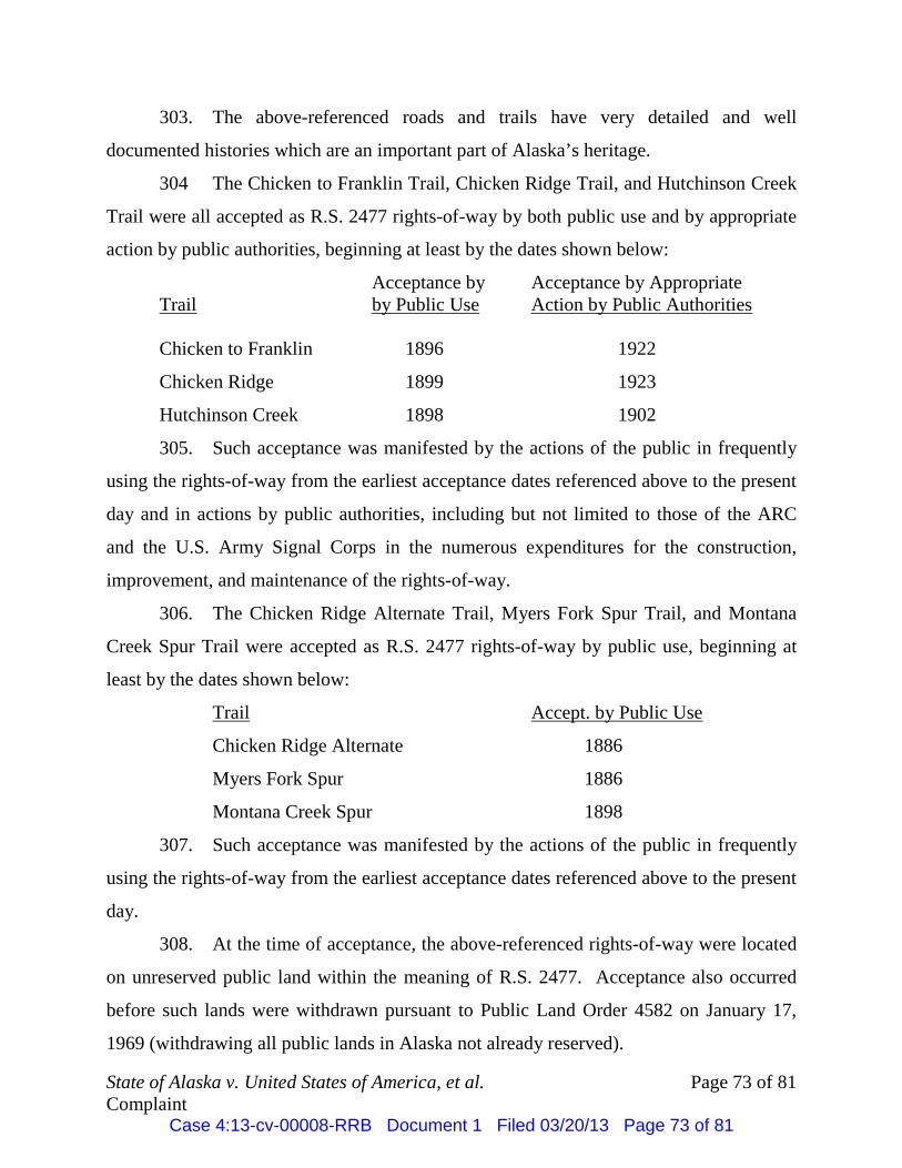
State of Alaska v. United States of America, et al. Page 73 of 81 Complaint
303. The above-referenced roads and trails have very detailed and well
documented histories which are an important part of Alaska’s heritage.
304 The Chicken to Franklin Trail, Chicken Ridge Trail, and Hutchinson Creek
Trail were all accepted as R.S. 2477 rights-of-way by both public use and by appropriate
action by public authorities, beginning at least by the dates shown below:
Acceptance by Acceptance by Appropriate Trail by Public Use Action by Public Authorities Chicken to Franklin 1896 1922
Chicken Ridge 1899 1923
Hutchinson Creek 1898 1902
305. Such acceptance was manifested by the actions of the public in frequently
using the rights-of-way from the earliest acceptance dates referenced above to the present
day and in actions by public authorities, including but not limited to those of the ARC
and the U.S. Army Signal Corps in the numerous expenditures for the construction,
improvement, and maintenance of the rights-of-way.
306. The Chicken Ridge Alternate Trail, Myers Fork Spur Trail, and Montana
Creek Spur Trail were accepted as R.S. 2477 rights-of-way by public use, beginning at
least by the dates shown below:
Trail Accept. by Public Use
Chicken Ridge Alternate 1886
Myers Fork Spur 1886
Montana Creek Spur 1898
307. Such acceptance was manifested by the actions of the public in frequently
using the rights-of-way from the earliest acceptance dates referenced above to the present
day.
308. At the time of acceptance, the above-referenced rights-of-way were located
on unreserved public land within the meaning of R.S. 2477. Acceptance also occurred
before such lands were withdrawn pursuant to Public Land Order 4582 on January 17,
1969 (withdrawing all public lands in Alaska not already reserved).
Case 4:13-cv-00008-RRB Document 1 Filed 03/20/13 Page 73 of 81

State of Alaska v. United States of America, et al. Page 74 of 81 Complaint
309. These rights-of-way constitute highways within the meaning of R.S. 2477.
310. Per AS 19.10.015 and DO 2665, the above-referenced rights-of-way each
possess a width of at least 100 feet, or 50 feet on each side measured from centerline of
the right-of-way.
311. Pursuant to the above-referenced federal rules and regulations as well as the
specifically cited federal authority, the federal lands at issue in this litigation over which
these rights-of-way pass, are subject to the State’s interest in these rights-of-way as valid
existing rights.
312. Any right, title or interest claimed by Defendant, the United States, in and
to the rights-of-way is inferior to the ownership interests of the State of Alaska acquired
pursuant to R.S. 2477.
313. The State is entitled to an order from this Court quieting title to the rights-
of-way at issue herein, as against the United States, based upon their status as public
highways pursuant to R.S. 2477.
COUNT II – SEEKING TO QUIET TITLE, AS AGAINST ALL NON-FEDERAL DEFENDANTS
BASED UPON R.S. 2477 & PURSUANT TO AS 09.45.010
314. The State re-alleges each of the foregoing paragraphs.
315. The above-referenced rights-of-way were accepted by public use and in
some instances, also by appropriate action by public authorities, beginning by at least the
dates referenced above.
316. At the time of acceptance the rights-of-way at issue were located on
unreserved public land within the meaning of R.S. 2477.
317. These rights-of-way constitute highways within the meaning of R.S. 2477.
318. Per AS 19.10.015 and DO 2665, the rights-of-way each possess a width of
at least 100 feet, or 50 feet on each side measured from centerline of the right-of-way.
319. Pursuant to the above-referenced rules and regulations as well as the
specifically cited federal authority, the lands at issue in this litigation over which these
rights-of-way pass were subject to the State’s interest in the rights-of-way as valid
Case 4:13-cv-00008-RRB Document 1 Filed 03/20/13 Page 74 of 81

State of Alaska v. United States of America, et al. Page 75 of 81 Complaint
existing rights, at the time of any reservation, withdrawal or conveyance by the federal
government.
320. Land conveyed by the United States is taken subject to previously
established rights-of-way, even where the instrument of conveyance is silent as to the
existence of the right-of-way.
321. Purchasers of land are charged with notice of an interest adverse to their
title when they are aware of facts which would lead a reasonably prudent person to
investigate and, when properly done, would lead to the knowledge that a servitude exists.
The purchaser is considered apprised of those facts obvious from such an inspection and
the lack of due diligence in pursuit of the required inquiry creates a conclusive
presumption that the purchaser knew of those facts which the inquiry would have
revealed.
322. As would have been reasonably apparent based upon a visual inspection of
any of the mining claims or parcels of private property set forth above, to the extent that
the above-referenced trails exist over and across the mining claims or parcels of private
property involved here, the roads and trails would have been visible and apparent at the
time the properties were originally staked, located, claimed, homesteaded, occupied, or
conveyed.
323. A reasonable investigation into the legal status of the roads and trails at the
time that any affected Defendant acquired an interest in any of the mining claims or
parcels of private property involved here would have revealed that it was used by the
public and that a public right-of-way existed.
324. Any right, title, or interest claimed by the non-federal Defendants in and to
these rights-of-way are inferior to the legal interests owned by the State of Alaska
acquired based upon R.S. 2477.
325. The State is entitled to an order from this Court quieting title to the rights-
of-way at issue here, as against the non-federal Defendants, and based upon their status as
public highways pursuant to R.S. 2477.
Case 4:13-cv-00008-RRB Document 1 Filed 03/20/13 Page 75 of 81

State of Alaska v. United States of America, et al. Page 76 of 81 Complaint
COUNT III – SEEKING TO QUIET TITLE, AS AGAINST ALL NON-FEDERAL DEFENDANTS (EXCLUDING AGNES M.
PURDY AND BARBARA A. REDMON, ON BEHALF OF ANNE L. PURDY), BASED UPON PUBLIC PRESCRIPTION AND PURSUANT TO AS 09.45.010
326. The State re-alleges each of the foregoing paragraphs.
327. The above-referenced rights-of-way have been used by the public
continuously and uninterrupted as a matter of right since the date of their earliest public
use as referenced above, through the present day. This period is far in excess of the
statutorily required period of 10 years to create an easement by public prescription.
328. Such use has occurred in a manner that has been open, notorious, adverse,
and hostile to the rights of the non-federal Defendants.
329. Any reference to non-federal Defendants in this Count specifically excludes
Agnes M. Purdy and Barbara A. Redmon, on behalf of Anne L. Purdy and the interests
they own in Native Allotment Nos. 50-2008-0437 and 50-2013-0004.
330. This use has occurred without the permission of the non-federal Defendants
or their predecessors.
331. Based upon the longstanding and historic use of the Chicken to Franklin
Trail, Chicken Ridge Trail, Chicken Ridge Alternate Trail, Myers Fork Spur Trail,
Hutchinson Creek Trail, and the Montana Creek Spur Trail, conducted as a matter of
right since their initial public use as noted above, the public has established a prescriptive
easement in these rights-of-way across the non-federal Defendants’ property.
332. The scope of the easement is year-round in nature and encompasses all
forms of travel, including but not limited to travel by foot, ski, dog sled, snowmachines,
four-wheelers, other off-highway vehicles, highway vehicles and heavy equipment. The
scope of the easement also includes use associated with various activities including, but
not limited to, use as a local travel corridor, access to mining claims, access to cabins,
hunting, hiking, skiing, trapping, dog sledding, and subsistence activities.
Case 4:13-cv-00008-RRB Document 1 Filed 03/20/13 Page 76 of 81

State of Alaska v. United States of America, et al. Page 77 of 81 Complaint
333. Any right, title or interest claimed by the non-federal Defendants in and to
the rights-of-way is inferior to the legal interests owned by the State on behalf of the
public and acquired via prescription.
334. The State of Alaska seeks an order from the Court quieting title to the
public rights-of-way set forth above, over and across the legal interests held by the non-
federal Defendants, based upon public prescription. The State also seeks confirmation
that based on this right, neither the non-federal Defendants nor their successors or assigns
are entitled to block, hinder or interfere with the public’s right of access over and across
these rights-of-way.
COUNT IV – SEEKING RECOVERY OF POSSESSION OF PROPERTY AS AGAINST ALL NON-FEDERAL DEFENDANTS
PURSUANT TO AS 09.45.630 335. The State re-alleges each of the foregoing paragraphs.
336. The State possesses a legal interest in the rights-of-way set forth herein.
337. The non-federal Defendants purport to be in possession of portions of the
rights-of-way that cross the property in which they hold interests.
338. Any right, title or interest claimed by the non-federal Defendants in and to
the rights-of-way is inferior to the legal interests owned by State.
339. The State has a present right to possession of the rights-of-way and is
entitled to recover possession of the same from the non-federal Defendants pursuant to
AS 09.45.630.
COUNT V – SEEKING A DECLARTORY JUDGMENT, AS AGAINST ALL DEFENDANTS,
PURSUANT TO 28 U.S.C. §2201
340. The State re-alleges each of the foregoing paragraphs.
341. The rights-of-way at issue here are valid existing rights, as against all
Defendants, based upon the status of the rights-of-way as public highways pursuant to
R.S. 2477 and also based upon their status, at least as to the non-federal Defendants
(excluding Agnes Purdy and Barbara A. Redmon on behalf of Anne L. Purdy), as public
prescriptive easements.
Case 4:13-cv-00008-RRB Document 1 Filed 03/20/13 Page 77 of 81

State of Alaska v. United States of America, et al. Page 78 of 81 Complaint
342. Defendant United States and others, including Defendants Agnes Purdy and
TCC, have wrongfully interfered with the State’s and public’s interests in these rights-of-
way by seeking to prohibit and/or unreasonably restrict use and access along the routes.
343. Defendant United States and others, including Defendant Agnes Purdy and
TCC, have wrongfully interfered with the State’s management and control of these public
rights-of-way as referenced above.
344. An actual controversy exists between the State, the United States and the
non-federal Defendants based upon the facts alleged.
345. Pursuant to 28 U.S.C. §2801, the State is entitled to a declaration that the
rights-of-way at issue are public highways and/or public prescriptive easements vesting
in favor of the State and that:
A. to the extent any conveyance from the United States to the non-
federal Defendants conflicts with the State of Alaska’s legal interest
in the same, such conveyance is subject to the State’s valid existing
rights;
B. the non-federal Defendants may not seek to block, restrict or
unreasonably interfere with the public’s right of access along the
rights-of-way, including by posting no-trespassing signs purporting
to prohibit the public’s use of the rights-of-way;
C. Defendant United States may not seek to unreasonably regulate use
of the rights-of-way, and may not regulate use within the rights-of-
way at all, except to do so in a manner reasonably calculated to
protect its adjacent lands and resources from damage;
D. Defendant United States may not seek to unreasonably interfere with
the State’s management and control of its right-of-way by, among
other things:
1. charging user fees associated with use of the rights-of-way;
2. requiring users to post bonds associated with use of the
rights-of-way;
Case 4:13-cv-00008-RRB Document 1 Filed 03/20/13 Page 78 of 81

State of Alaska v. United States of America, et al. Page 79 of 81 Complaint
3. categorically limiting users of the rights-of-way in the timing
of their trips, frequency of travel and modes of transportation;
4. forcing users to obtain and/or pay for environmental
assessments regarding impacts to the rights-of-way
themselves;
5. requiring users to gate or block the rights-of-way or to in any
manner, discourage use by others;
6. preventing or interfering with the State’s right to conduct or
authorize routine maintenance of the rights-of-way; and
E. Defendant, United States, may not include these rights-of-way
within the boundaries of its conservation system units.
COUNT VI – CONDEMNING PORTIONS OF THE AGNES M. PURDY & ANNE L. PURDY NATIVE ALLOTMENTS
PURSUANT TO 25 U.S.C. §357
346. The State re-alleges each of the foregoing paragraphs.
347. State authority for the condemnation and regulation of public highways by
the State of Alaska is provided by State law pursuant to AS 19.05, 19.10, 19.20 and
AS 09.55. 25 U.S.C. §357 authorizes condemnation of Native allotment lands pursuant
to State laws.
348. This count is brought and pled by the State of Alaska, in the alternative, to
confirm in the State and/or take a right-of-way for the above-referenced roads and trails
where they traverse the Agnes Purdy Native Allotment, No. 50-2008-0437, and the Anne
L. Purdy Native Allotment, No. 50-2013-0004.
349. The real property to be confirmed and/or condemned is a right-of-way over
that portion of the Native allotments situated within 50 feet on each side of the centerline
of the roads and trails traversing the allotments as specifically depicted on Exhibit “1.”
350. The interest to be confirmed and/or acquired in the State is an easement in
the form of a public highway right-of-way.
Case 4:13-cv-00008-RRB Document 1 Filed 03/20/13 Page 79 of 81

State of Alaska v. United States of America, et al. Page 80 of 81 Complaint
351. The above-described area is located within T. 27 N., R. 18 E., Copper River
Meridian, State of Alaska, and as more specifically depicted on attached Exhibit “1,”
containing approximately 17.5 acres of land within the Agnes Purdy Native Allotment,
No. 50-2008-0437, and approximately 6.4 acres of land within the Anne L. Purdy Native
Allotment, No. 50-2013-0004.
352. Persons and entities known to the State to have, claim, or who may claim
an interest in the property subject to this count are identified at paragraphs 15 – 21, which
are specifically incorporated into this count by reference.
353. The right-of-way confirmation and/or acquisition is necessary to continue
public access for highway purposes along the rights-of-way at issue herein.
354. The above-referenced Native allotments are subject to the State of Alaska’s
valid existing rights-of-way for the above-referenced roads and trails by operation of the
following (in combination or in the alternative):
A. R.S. 2477;
B. the language contained in Native Allotment Certificate Number 50-
2008-0437; and
C. the language contained in Native Allotment Certificate Number 50-
2013-0004.
355. Given the State’s pre-existing rights-of-way over the allotments, no
compensation is owed to any individual or entity who may claim an interest adverse to
the State’s rights-of-way.
PRAYER FOR RELIEF
Therefore, the Plaintiff, State of Alaska, prays for the following relief:
A. that the Court quiet title to the State of Alaska in and to the referenced
rights-of-way, as against all Defendants, based upon R.S. 2477;
B. that the Court quiet title to the State of Alaska in and to the referenced
rights-of-way, as against the non-federal Defendants (excluding Agnes Purdy and
Barbara A. Redmon on behalf of Anne L. Purdy), based upon public prescription;
Case 4:13-cv-00008-RRB Document 1 Filed 03/20/13 Page 80 of 81

State of Alaska v. United States of America, et al. Page 81 of 81 Complaint
C. that the Court enter a declaratory judgment consistent with the relief
referenced above;
D. that the Court declare that the above-referenced Native allotments are
subject to Alaska’s valid rights-of-way in and to the roads and trails referenced on
Exhibit “1” that traverse the allotments;
E. that the Court enter judgment condemning any adverse interest claimed by
the private Defendants in the State’s rights-of-way across the Native allotments at issue
here;
F. that the Court declare that the private Defendants are prevented from
obstructing, interfering with, or infringing upon the public’s right-of-access within the
State’s rights-of-way traversing the allotments;
G. that the State of Alaska be awarded its costs and attorney’s fees incurred;
and
H. for such further and other relief as the Court may deem just and proper.
DATED this 20th day of March, 2013.
MICHAEL C. GERAGHTY MICHAEL C. GERAGHTY ATTORNEY GENERAL ATTORNEY GENERAL By:/s/Z. Kent Sullivan By:/s/R. Poke Haffner Z. Kent Sullivan (AK Bar No. 0105038) R. Poke Haffner (AK Bar No. 8106025) Assistant Attorney General Assistant Attorney General Department of Law Department of Law P.O. Box 110300 100 Cushman Street, Suite 400 Juneau, Alaska 99811-0300 Fairbanks, Alaska 99701 Telephone: (907) 465-3600 Telephone: (907) 451-2936 Facsimile: (907) 465-2539 Facsimile: (907) 451-2846 Email: [email protected] Email: [email protected] Attorney for State of Alaska Attorney for State of Alaska
Case 4:13-cv-00008-RRB Document 1 Filed 03/20/13 Page 81 of 81

State of Alaska v. United States of America, et al. Page 1 of 5 Table of Exhibits1
MICHAEL C. GERAGHTY ATTORNEY GENERAL Z. Kent Sullivan (Alaska Bar No. 0105038) R. Poke Haffner (Alaska Bar No. 8106025) Assistant Attorneys General Department of Law P.O. Box 110300 Juneau, Alaska 99811-0300 Telephone: (907) 465-3600 Facsimile: (907) 465-2539 Email: [email protected] [email protected] Attorneys for State of Alaska
IN THE UNITED STATES DISTRICT COURT FOR THE DISTRICT OF ALASKA
STATE OF ALASKA DEPARTMENT OF NATURAL REOURCES and DEPARTMENT OF TRANSPORTATION AND PUBLIC FACILITIES,
Plaintiffs,
v.
UNITED STATES OF AMERICA; AGNES M. PURDY, Owner of Native Allotment No. 50-2008-0437 (certificate no.); that portion of Native Allotment No. 50-2008-0437 currently occupied by the Chicken Ridge Alternate, Myers Fork Spur, Chicken to Franklin and Chicken Ridge Trails, and containing approximately 17.5 acres of land; BARBARA A. REDMON, on behalf of Anne L. Purdy, Owner of Native Allotment No. 50-2013-0004 (certificate no.); that portion of Native Allotment No. 50-2013-0004 currently occupied by the Chicken to Franklin and Chicken Ridge Trails, and containing approximately 6.4 acres of land;
) ) ) ) ) ) ) ) ) ) ) ) ) ) ) ) ) ) ) ) ) ) ) ) )
Case No.: TABLE OF EXHIBITS
Case 4:13-cv-00008-RRB Document 1-1 Filed 03/20/13 Page 1 of 5
State of Alaska v. United States of America, et al. Page 2 of 5 Table of Exhibits2
DENA’ NENA’ HENASH, a/k/a Tanana Chiefs Conference, an Alaska non-profit corporation; GEORGE W. SEUFFERT, SR.; CHICKEN VENTURES, LLC, an Alaska limited liability company; GEORGE W. SEUFFERT, JR.; BRONK G. JORGENSEN; THOR D. JORGENSEN; MICHAEL R. BUSBY; ANTON J. HANAK; MILLROCK ALASKA, LLC, an Alaska limited liability company; CHARLES R. HAMMOND; ALASKA EARTH RESOURCES, INC., an Alaska corporation; WILLIAM M. MASSENGALE; FRANCES E. MASSENGALE; MASTODON MINING, LLC, an Alaska limited liability company, MARK S. BREECE; SHELDON F. MAIER; JANNE H. MAIER; SILVER J. STROER; EVA L. STROER; TYE R. KIRSCH; DWAIN L. GIBSON; DAVID N. DONALD; TERRI CASE; RICK H. DOBBELAERE; WILLIAM H. BAYLESS; SIEGLINDE U. DAACK; FORTYMILE MINING DISTRICT, a/k/a Forty Mile Mining Association, an Alaska non-profit corporation; and other persons unknown, claiming or who might claim any right, title, estate or interest in or lien or encumbrance upon, the real property described in the Complaint, or any part thereof, adverse to Plaintiff’s ownership, or any cloud upon Plaintiff’s title thereto, whether such claim or possible claim be present or contingent,
Defendants. ___________________________________
) ) ) ) ) ) ) ) ) ) ) ) ) ) ) ) ) ) ) ) ) ) ) ) ) ) ) ) ) ) ) ) ) ) ) ) )
Exhibit “1” Chicken Area Litigation Overview Map. Exhibit “2” Historic Photographs.
Case 4:13-cv-00008-RRB Document 1-1 Filed 03/20/13 Page 2 of 5

State of Alaska v. United States of America, et al. Page 3 of 5 Table of Exhibits3
Exhibit “3 1990 BLM Map of Eagle – Valdez Trail. Exhibit “4” 1899 USGS Topographic Map, Alaska Fortymile Quadrangle. Exhibit “5” 1902 Map of Vicinity of Eagle, Alaska. Exhibit “6” 1904 USGS Reconnaissance Map of Yukon-Tanana Region Alaska. Exhibit “7” 1907 Map of Alaska Showing Roads, Trails, Telegraph Lines and Military
Posts. Exhibit “8” 1903 Directive From U.S. Postmaster General. Exhibit “9” 1924 Alaska Road Commission Eagle Sub-District Map. Exhibit “10” 1951 USGS Topographic Map, Eagle, Alaska. Exhibit “11” 1956 USGS Topographic Map, Eagle (A-2) Quadrangle. Exhibit “12” 1954-57 USGS Aerial Photographs (Chicken to Franklin Trail). Exhibit “13” Contemporary Photographs of Lower Portions of Chicken to Franklin Trail. Exhibit “14” Contemporary Photographs of Chicken to Franklin Trail in Area of
Mountain Divide Between Chicken and Franklin. Exhibit “15” Contemporary Photographs of Chicken to Franklin Trail of the Southern
Fork Near Franklin. Exhibit “16” Contemporary Photographs of the Chicken to Franklin Trail of the Middle
Fork (Kettle George) Near Franklin. Exhibit “17” Contemporary Photographs of the Chicken to Franklin Trail on the
Northern Fork (Franklin Creek). Exhibit “18” 1914 USGS Map Published as Water Supply Paper 342, Plate 4, Yukon –
Tanana Region. Exhibit “19” WAMCATS Maps. Exhibit “20” 1977 WAMCATS Route Map, U.S. Bureau of Outdoor Recreation. Exhibit “21” 1916 ARC Map.
Case 4:13-cv-00008-RRB Document 1-1 Filed 03/20/13 Page 3 of 5

State of Alaska v. United States of America, et al. Page 4 of 5 Table of Exhibits4
Exhibit “22” 1957 USGS Topographic Map, Eagle (A-3) Quadrangle. Exhibit “23” 1954-57 USGS Aerial Photographs (Chicken Ridge, Chicken Ridge
Alternate, and Myers Fork Spur Trails). Exhibit “24” Contemporary Photographs of Chicken Ridge Trail Along Ridgeline
Between Myers Fork and Stonehouse Creeks. Exhibit “25” Contemporary Photographs of the Chicken Ridge Trail on Chicken Ridge
Between Buckskin Creek and the Mosquito Fork of the Fortymile River. Exhibit “26” 1963 BLM Aerial Photographs of the Chicken Ridge Alternate and Myers
Fork Spur Trails. Exhibit “27” 2011 Aerial Photograph of the Chicken Ridge, Chicken Ridge Alternate
and Myers Fork Spur Trails. Exhibit “28” Contemporary Photographs of the Chicken Ridge Alternative Trail. Exhibit “29” 1988 BLM Purdy Allotments Map by Pamula J. Bossonnette. Exhibit “30” 1997 BLM Aerial Photographs of Myers Fork Spur and Chicken Ridge
Trails. Exhibit “31” U.S. Survey No. 13799. Exhibit “32” Contemporary Photographs of Myers Fork Spur Trail. Exhibit “33” 1899 Map From Liberty Creek Mining District (referencing Hutchinson
and Montana Creeks). Exhibit “34” 1904 Map Entitled Part of Alaska – Survey for Wagon Road From Valdez
to Ft. Egbert. Exhibit “35” 1904 U.S. Army Wagon Road Plat of the Hutchinson Creek Drainage. Exhibit “36” 1956 USGS Topographic Map, Eagle (B-3) Quadrangle. Exhibit “37” 1955 USGS Aerial Photograph of Hutchinson and Montana Creeks. Exhibit “38” Contemporary Photographs of the Hutchinson Creek Trail.
Case 4:13-cv-00008-RRB Document 1-1 Filed 03/20/13 Page 4 of 5

State of Alaska v. United States of America, et al. Page 5 of 5 Table of Exhibits5
Exhibit “39” Contemporary Photographs of the Montana Creek Spur Trail. Exhibit “40” Photograph of BLM Sign at the Entrance to the Wild and Scenic River
Corridor on the Chicken to Franklin Trail. Exhibit “41” Finding of No Significant Impact and Decision Record, Hutchinson Creek
Access Amended right of Way, E.A. AK-024-07-009 FF092963, Dated August 25, 2007.
Exhibit “42” Letter From Robert C. Burritt, United States Department of the Interior, to
Mr. Bill Bayless, Dated February 8, 1994. Exhibit “43” Environmental Assessment for Bill Bayless, Mining Claim FF091025,
Undated. Exhibit “44” Letter of Decision From Lenore Heppler, United States Department of the
Interior, to Sheldon Maier, Dated March 2007. Exhibit “45” Stipulation and Mitigation Measures for Robert Lopetrone, Mining Claim
FF092963, Hutchinson Creek, Dated October 6, 2000. Exhibit “46” Environmental Assessment and Decision of Record for Hutchinson Creek
Access Right-of-Way Proposal, Dated May 2008. Exhibit “47” Stipulations for Mining Claims FF091025 and FF092588, for Bill Bayless
at Franklin Creek, Undated. Exhibit “48” Section 7 Determination for Hutchinson Creek, Tributary of the Fortymile
National Wild and Scenic River, Dated October 9, 2008. Exhibit “49” Letter from Alaska BLM State Director, Bud Cribley, to Sheldon Maier,
President of the Forty Mile Miners Association, Dated October 23, 2002.
Case 4:13-cv-00008-RRB Document 1-1 Filed 03/20/13 Page 5 of 5