Embed Size (px)
Citation preview
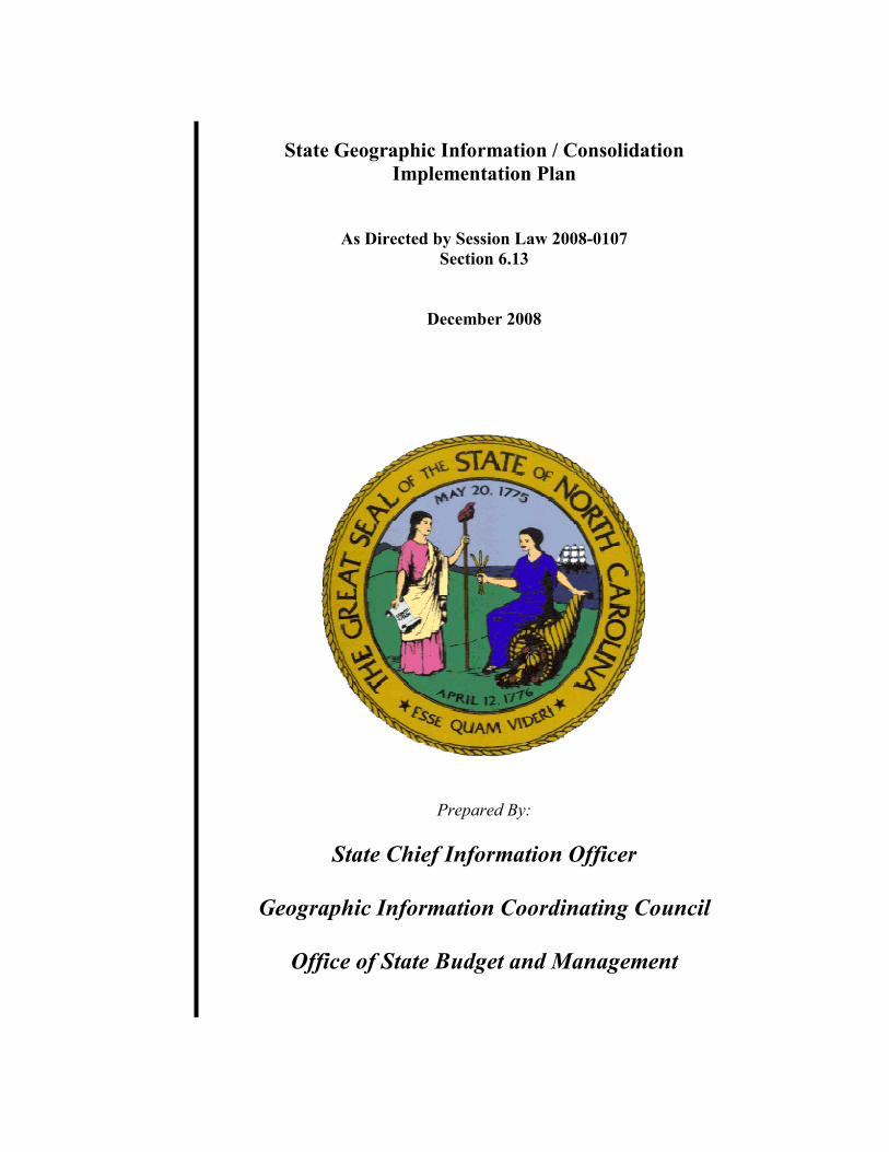
State Geographic Information / Consolidation
Implementation Plan
As Directed by Session Law 2008-0107
Section 6.13
December 2008
Prepared By:
State Chief Information Officer
Geographic Information Coordinating Council
Office of State Budget and Management

2
[THIS PAGE IS INTENTIONALLY LEFT BLANK]
3
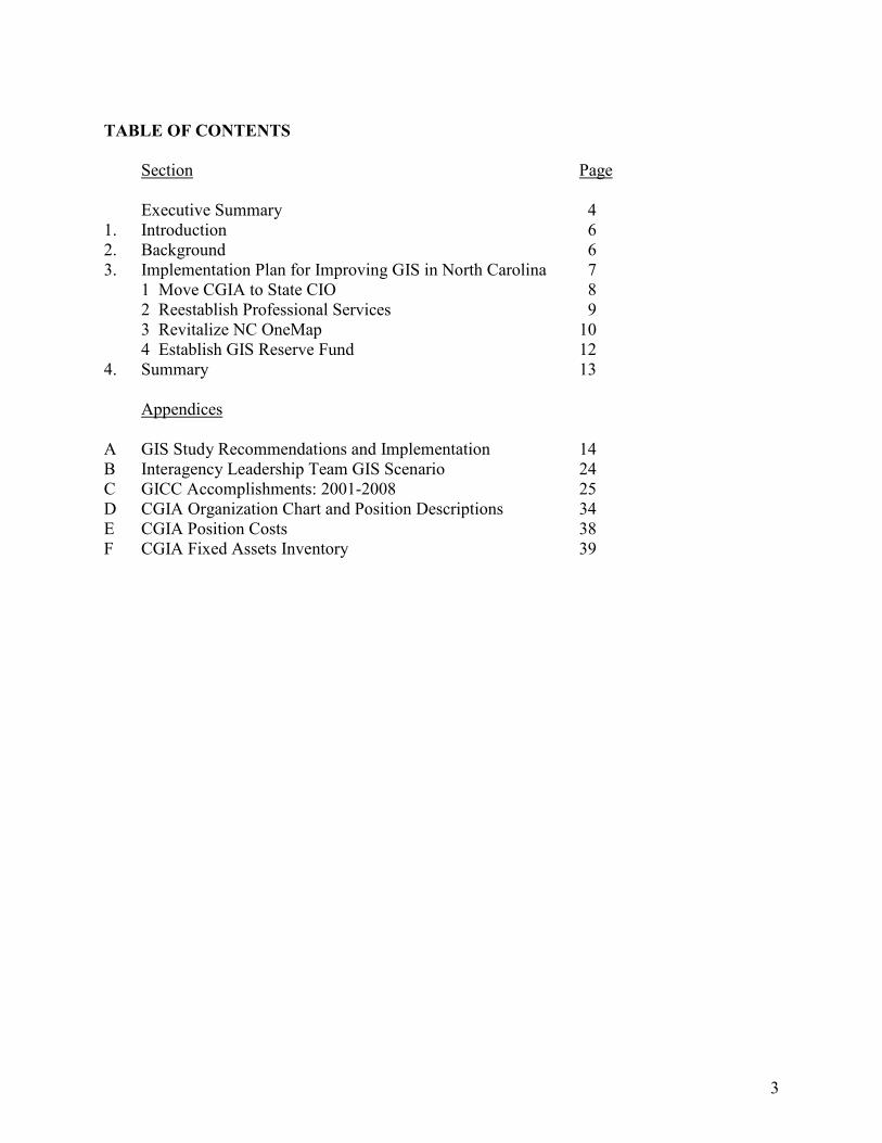
TABLE OF CONTENTS
Section Page Executive Summary 4 1. Introduction 6 2. Background 6 3. Implementation Plan for Improving GIS in North Carolina 7 1 Move CGIA to State CIO 8 2 Reestablish Professional Services 9 3 Revitalize NC OneMap 10 4 Establish GIS Reserve Fund 12 4. Summary 13 Appendices A GIS Study Recommendations and Implementation 14 B Interagency Leadership Team GIS Scenario 24 C GICC Accomplishments: 2001-2008 25 D CGIA Organization Chart and Position Descriptions 34 E CGIA Position Costs 38 F CGIA Fixed Assets Inventory 39
4
EXECUTIVE SUMMARY
The critical need for consolidating the investments made in geographic information and developing common infrastructures, and the potential benefits, were documented in a Geographic Information Systems (GIS) Study report to the General Assembly in February 20081. Consolidation would streamline governance, place GIS in a better organizational structure and increase the state’s ability to utilize federal and local support. Upon receiving the report the General Assembly directed the development of a detailed and phased implementation plan. This plan builds upon the GIS Study report with additional organizational and implementation details and proposes a phased implementation to reduce risk and ensure return on investment. In addition it proposes minimum funding to insure continued fiscal viability of statewide GIS management. Under this proposal, implementation will occur in the following four steps:
1. Move the CGIA to the Office of the State CIO and establish appropriated funding for staff activities supporting the GICC, statewide standards, and the coordination of data acquisition.
2. Reestablish the professional services effort without the burden of GICC staff overhead and refocus the organization on current needs of the community.
3. Revitalize the NC OneMap project by leveraging new technology in the market to reduce costs while increasing utility of the service.
4. Establish a GIS Reserve fund for the acquisition of data layers which may be useful by multiple organizations and through which data acquisition may be procured to reduce cost.
Step one will place the staff supporting statewide GIS efforts under the governance of the State CIO. This will move seven existing positions involved in support for the GICC, including the Director of the CGIA, and establish funding of $650,000 for these positions from the Enterprise IT fund. These positions are currently funded as overhead on the GIS professional services organization. Step two will move eleven professional services staff to the Office of the State CIO and establish marketable rates without the overhead of the governance staff. This will allow these services to be competitively priced and will provide local and state agencies with skilled professionals familiar with State operations. This activity will require no new funding. Step three will refresh the technology used in NC OneMap, an important collection of GIS information gathered by state and local agencies. This step will involve moving two state appropriated positions which support NC OneMap and will require funding for the technology refresh. The two positions are currently funded at $170,000 annually. The refresh will require
1 View the report at http://www.osbm.state.nc.us/files/pdf_files/GISStudyFinal02012008.pdf
5
$372,000 in non-recurring funds and $140,000 in recurring funding for hardware and software maintenance. The fourth and final step will establish a non-reverting reserve fund from which GIS data acquisition may be funded. The GICC will manage the fund which may include federal funds, revenue from contracts or grants and appropriated money. No appropriated funds are requested during the first year of the plan. During this year, the GICC will establish a plan for coordinating acquisition of data layers and will utilize existing funds. Should the General Assembly choose to match local and federal funding as recommended in the GIS Study report, funds appropriated will be placed in the reserve fund and administered as directed by statute. By carrying out this plan, the State can ensure continued coordination of state and local GIS activities. This coordination will result in savings in the acquisition of GIS data layers, broader availability of data through standardization, and better services for constituents at all levels of government.
6
1. INTRODUCTION
This detailed plan to implement the recommendations provided in the GIS Study is a joint effort between the State Chief Information Officer (SCIO), the Office of State Budget and Management (OSBM) and the Geographic Information Coordinating Council (GICC). These groups are familiar with the situation today regarding investments that have been made in GIS in North Carolina and visualize efficiencies and ultimately cost savings when the 21 recommendations are fully implemented. See Appendix A for a complete list of the 21 recommendations and the proposed implementation of each.
2. BACKGROUND
The critical need for consolidating the investments made in geographic information and developing common infrastructures, and the potential benefits, were documented in a report to the General Assembly in February 2008. After receiving the report, the General Assembly directed the development of a detailed implementation plan in Session Law 2008-0107, Section 6.13. Consolidation would streamline governance, place GIS in a better organizational structure, and increase the state’s ability to utilize federal and local support. Geographic information is used by all levels of government to support the delivery of many critical services. Road building, natural resource management, school bus routing, economic development, crime management and emergency planning and management are just a few of the uses of geographic information. There are many others. For example, the Interagency Leadership Team is comprised of state and federal agencies charged with planning transportation projects which are successfully balanced with natural and cultural resource protection, community values and economic vitality. This team created a business case for GIS as a means for saving money. The case identified $34 million in annual savings from delivering transportation projects more effectively. Appendix B contains more information on using GIS to improve transportation projects. Since its creation by the Legislature in 2001, the Geographic Information Coordinating Council (GICC) and an active group of committees have worked to develop standards; coordinate the acquisition of geographical data layers; and leverage funding from state, federal, and local sources to the benefit of the State. The Council serves as an important forum which engages both public and private participants in GIS. The function and success of the Council were well documented in the 2008 GIS Study legislative report. The accomplishments of the GICC since 2001 are listed in Appendix C. The Center for Geographic Information and Analysis (CGIA) provides several important functions in the public and private GIS community in North Carolina. These functions include serving as executive staff to the GICC; providing GIS skills to state and local agencies through a professional services organization; and operating NC OneMap, a repository of GIS data accumulated from state and local agencies. An organizational chart showing the current CGIA organization may be found in Appendix D.
7
Funding for the CGIA is primarily from receipts on professional services provided to state and local agencies. There are two appropriated positions which support the operation of NC OneMap. When the GICC was created in 2001 there were no funds appropriated to staff the activities of the Council. The staff activities needed to execute the significant activities of the Council and associated committees and working groups are carried as overhead on the professional services organization. This funding mechanism for the activities of the Council has proven to be financially unviable. In order to generate funds for both professional services and the management overhead and work of the Council, the rates for professional services are unreasonably high. These uncompetitive rates make it difficult for state agencies and local governments to justify the services and have seriously constrained the effectiveness of both professional services and staff support for the Council. Further, with extremely limited funding, NC OneMap, while successful in some ways, has been unable to achieve many of the original objectives and potential new objectives. The value of achieving these objectives has actually increased with time and rising dependence on geographic information at all levels of government. The following implementation plan details the steps to be taken to: build upon the successful work of the GICC; establish a minimum funding structure for this work; stabilize the professional services organization by unburdening it from unnecessary overhead and to reinvigorate the NC OneMap effort; and make the valuable information that it contains much more consumable and readily accessible by citizens and other public and private entities.
3. IMPLEMENTATION PLAN FOR IMPROVING GIS IN NORTH CAROLINA
The General Assembly, through Session Law 2008-0107, Section 6.13, requested a detailed plan to implement the recommendations outlined in the GIS Study. Specifically, Section 6.13 required that “The implementation plan shall include, at a minimum, details relating to all of the following:
(1) The current and future costs of unconsolidated State agency GIS efforts and an estimate of savings to be realized by the consolidation of GIS efforts.
(2) A cost estimate for implementing the consolidation plan, with specific costs associated with each study recommendation and the amount of any additional funding requirements to accomplish the consolidation and transfer.
(3) An accounting of funds, equipment, furniture and other operational resources to be transferred from the Department of Environment and Natural Resources (DENR) to the SCIO to support the Center for Geographic Information and Analysis (CGIA) and the GICC.
(4) A description of personnel positions to be (i) transferred from DENR to SCIO and the sources and amount of funding associated with each position and (ii) eliminated due to the consolidation, if any.
(5) Any new positions required and the costs associated with each new position. (6) Projects that can be consolidated as part of the plan implementation and the State
8
agencies or contractors, or both, responsible for each of those projects. (7) A time line for implementation, including specific benchmarks.
By December 1, 2008, this detailed implementation plan shall be submitted to the Chairs of the House and Senate Appropriations Committees and to the Fiscal Research Division of the Legislative Services Office.”
Implementation Summary
Within the context of the GIS Study recommendations, the term ‘consolidation’ pertains to organizational structure and data layer development and maintenance. These are the two areas where the State can achieve the largest return on investment. The recommendations outlined in the 2008 GIS Study legislative report will be implemented in four distinct work streams. The first three are proposed to be accomplished in first year activities. The fourth will be planned during the first year and executed in year two. The four work streams are:
1. Move the CGIA to the Office of the State CIO and establish appropriated funding for staff activities supporting the GICC, statewide standards, and the coordination of data acquisition.
2. Reestablish the professional services effort without the burden of GICC staff overhead and refocus the organization on current needs of the community.
3. Revitalize the NC OneMap project by leveraging new technology in the market to reduce costs while increasing utility of the service.
4. Establish a GIS Reserve fund for the acquisition of data layers which may be useful by multiple organizations and through which data acquisition may be procured to reduce cost.
Implementation Details
1 Move the CGIA to the Office of the State CIO and establish appropriated funding for
staff activities supporting the GICC, statewide standards, and the coordination of data
acquisition.
Per the recommendations in the GIS Study report, the CGIA will be moved to report directly to the State CIO. Working with the GICC, the Director of the CGIA and the State CIO have determined that seven (7) positions within CGIA are primarily responsible for staffing GICC activities and carrying out functions associated with statewide standards and coordination as documented by the GICC list of accomplishments in Appendix C. These positions are:
• IT Director
• Business and Technology Applications Specialist (2 positions)
• Information and Communications Specialist III
• Technology Support Analyst
• Business Officer
9
• Office Assistant III The total cost of the positions (salaries and benefits) is $537,125 with an additional $112,800 in operational funds for a total of $649,925. A more detailed breakdown of position costs can be found in Appendix E under ‘GICC Governance’. Consistent with other statewide functions such as the Enterprise Project Management Office, IT Procurement, and IT Architecture, these positions should be funded through appropriations. No new positions will be required, but the positions will be moved from being receipts-supported to appropriated funds. The new appropriation required is approximately $650,000. The fixed assets (i.e., furniture, equipment) to be transferred from DENR to the State CIO for these positions are listed in Appendix F. This work stream addresses Recommendations 6, 7, 8, 9, and 10 as presented in Appendix A, attached hereto. The timeline for this work is July 1, 2009 through September 30, 2009.
2 Reestablish the professional services effort without the burden of GICC staff overhead
and refocus the organization on current needs of the community.
CGIA professional services provide valuable skills to state and local agencies in the area of GIS. These services are attuned to state requirements, state processes, enterprise licenses, and procurement and can save both time and money in the execution of complex projects. The current stable of consultants consists of the following 11 positions:
• IT Manager
• Business and Technology Applications Specialist
• Business and Technology Applications Analyst (2 positions)
• Operations and Systems Analyst
• Technology Support Analyst (3 positions)
• GIS Technician (3 positions) A more detailed breakdown of position costs for these positions can be found in Appendix E under ‘Professional Services’. These positions will be moved to the Office of the State CIO and will continue to be receipts supported. Competitive rates for their activities will be established through OSBM as with all other ITS rates. Since these rates will no longer be burdened by the substantial GICC staff overhead costs, they should prove to be of greater value to potential public sector customers. Over time the size and make-up of the group may be changed to meet demand and required skill sets. The fixed assets (i.e., furniture, equipment) to be transferred from DENR to the State CIO for these positions are listed in Appendix F. This work stream addresses Recommendation 10 as provided in Appendix A. The timeline for this work is July 1, 2009 through September 30, 2009.
10
3 Revitalize the NC OneMap project by leveraging new technology in the market to
reduce costs while increasing utility of the service.
When NC OneMap was launched as a visionary program, there were two primary purposes articulated for the system. The first purpose was to provide a collection of geographical data developed by government – federal, state, and local – that would be readily available for use by government and private entities. The second purpose was to provide an easily used viewing capability for this data for people without sophisticated GIS software. Both purposes have been achieved with limited success. At the time the program was conceived it was difficult to envision the widespread commodity utilization of GIS information for individual use and for consumption by application systems of many types. The demand for GIS data and the ways in which that data is consumed far exceeds the funding and scope of the NC OneMap program. Technology and the marketplace have left the ability of the program to deliver behind. However, the original goals of the program are even more important to government and citizens today. The NC OneMap program has succeeded in creating a very significant repository of GIS data layers for use by all. Fifty counties, 26 cities and towns, six councils of government, three federal agencies, and five state agencies contribute datasets to the NC OneMap collection. These datasets are available for those with sophisticated GIS analysis software to use for many purposes. Standards for data approved by the GICC have made it easier to use and reuse data. There are two common issues which restrict participation by government agencies. The first of these is concern over control of access to the data. Local governments have a different statutory framework for data and are allowed to hold and sell data such as GIS layers. Currently, this data becomes available without constraint if contributed to NC OneMap. In addition to revenue concerns, there are GIS data sets which, while critical to government operations, should not be released to the public due to public safety and security concerns. The second issue which prevents participation in NC OneMap is simple. Many of the small agencies, towns, or economically challenged counties may not have the resources to participate. Yet participation enhances services for all and with the widely expanded ability of the market to consume GIS information, this is more important than ever. NC OneMap efforts to provide readily available viewing of GIS data have produced a viewer which presents much of the data through a simple web interface. Although this viewer works, when compared to sophisticated viewers such as Google Earth or Microsoft’s Virtual Earth there are significant improvements that could be made. There are new purposes and consumer needs for data from NC OneMap. Many applications, such as the new Sex Offender Registry, consume map data as an application. These applications require the ability to request maps from a source and then incorporate these maps into the presentation of other geospatially referenced data. Currently, NC OneMap provides very limited ability to serve these needs.
11
The following is an initial framework proposal to implement a new NC OneMap. The new NC OneMap will exhibit the following characteristics:
• It will leverage off-the-shelf software from vendors such as Google, Microsoft, or open source providers to dramatically limit custom development. This will also ensure the broad availability of viewing tools across many end-user devices, such as mobile phones, and expand the reach of the site.
• It will provide a consistent and ready platform through which geospatially referenced information may be delivered without application development. For example, the Sex Offender map may have been delivered with no new development required.
• There will be role-based access to the system. Data which is appropriately available to all may be presented without authentication, but for those datasets restricted by security or legitimate data stewardship concerns, appropriate authentication will be required.
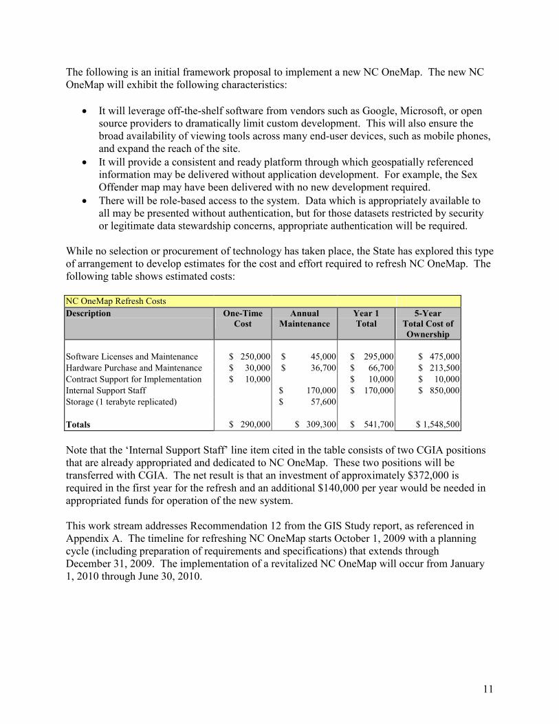
While no selection or procurement of technology has taken place, the State has explored this type of arrangement to develop estimates for the cost and effort required to refresh NC OneMap. The following table shows estimated costs: NC OneMap Refresh Costs
Description One-Time
Cost
Annual
Maintenance
Year 1
Total
5-Year
Total Cost of
Ownership
Software Licenses and Maintenance $ 250,000 $ 45,000 $ 295,000 $ 475,000
Hardware Purchase and Maintenance $ 30,000 $ 36,700 $ 66,700 $ 213,500
Contract Support for Implementation $ 10,000 $ 10,000 $ 10,000
Internal Support Staff $ 170,000 $ 170,000 $ 850,000
Storage (1 terabyte replicated) $ 57,600
Totals $ 290,000 $ 309,300 $ 541,700 $ 1,548,500
Note that the ‘Internal Support Staff’ line item cited in the table consists of two CGIA positions that are already appropriated and dedicated to NC OneMap. These two positions will be transferred with CGIA. The net result is that an investment of approximately $372,000 is required in the first year for the refresh and an additional $140,000 per year would be needed in appropriated funds for operation of the new system. This work stream addresses Recommendation 12 from the GIS Study report, as referenced in Appendix A. The timeline for refreshing NC OneMap starts October 1, 2009 with a planning cycle (including preparation of requirements and specifications) that extends through December 31, 2009. The implementation of a revitalized NC OneMap will occur from January 1, 2010 through June 30, 2010.
12
4 Establish a GIS Reserve fund for the acquisition of data layers which may be useful by
multiple organizations and through which data acquisition may be procured to reduce
cost.
The GIS data layers used by state and local government are acquired using federal, state and local funds – very often in combination. Activities to create and refresh layers may be executed by local government staff during the normal process of business, through special projects or through contracted services, such as flyovers to acquire orthophotography. Data acquisition may be required for specific times – for example, leaf-on photography and leaf-off photography are used for different purposes. The net result is that acquisition of data does not align itself well with fiscal boundaries and budget cycles. The GICC has demonstrated success in reducing costs by coordinating the acquisition of data between local and state efforts. For example, flyovers may cost significantly less when adjacent domains are acquired in the same project and contract. Further, there are many circumstances where multiple agencies require the same data layers. Acquisition through singly managed contracts can save money and improve data. This has proven difficult to do when funds come from multiple agencies with multiple sources of funding. The creation of a GIS Reserve fund, a special revenue fund managed by GICC as created under GS 143-725, -727 would allow these contracts to be managed. The funds would not revert at the end of a fiscal year. Revenue for the fund may consist of gifts, grants, contracts, and appropriations by the General Assembly. Under this implementation plan the fund would be created, without any appropriated funds during the first year activity. During that first year, the GICC will develop the Statewide GIS Strategy. Part of the development of the strategy will be setting priorities for GIS data layers. Orthophotography is such a critical data layer that a business plan will be written to address it. This plan will feed into the broader Statewide GIS Strategy. With the Statewide GIS Strategy in place, funding sources will be sought to accomplish data acquisition to meet the needs of users. Any need for appropriated funds to initiate the GIS Reserve fund will be identified during this overall planning effort. This work stream is related to Recommendations 1 through 5, Recommendation 11, and Recommendations 13 through 19 in the GIS Study report, as referenced in Appendix A. The timeline for this work begins July 1, 2009 with completion of both the Statewide GIS Strategy and the business plan for orthophotography by December 31, 2009.
13
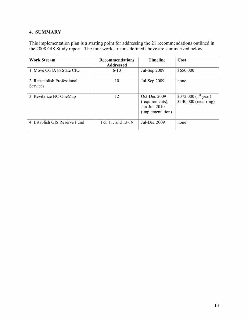
4. SUMMARY
This implementation plan is a starting point for addressing the 21 recommendations outlined in the 2008 GIS Study report. The four work streams defined above are summarized below. Work Stream Recommendations
Addressed
Timeline Cost
1 Move CGIA to State CIO
6-10 Jul-Sep 2009 $650,000
2 Reestablish Professional Services
10 Jul-Sep 2009 none
3 Revitalize NC OneMap 12 Oct-Dec 2009 (requirements); Jan-Jun 2010 (implementation)
$372,000 (1st year) $140,000 (recurring)
4 Establish GIS Reserve Fund
1-5, 11, and 13-19 Jul-Dec 2009 none
14
Appendix A: GIS Study Recommendations and Implementation
The 2008 GIS Study report provided 21 recommendations to improve the delivery of GIS in North Carolina. Each recommendation is listed along with implementation steps and a timeline. Words in bold italics represent minor changes in the recommendations that were listed in the GIS Study report. These changes serve to clarify the intent of each recommendation rather than alter it and update information that has changed since the GIS Study report was written. Recommendation 1 Task the GICC through the Management and Operations (M&O) Committee with the responsibility of setting and managing the Statewide GIS Strategy. Implementation Steps: The GICC was created in the General Statutes to advise the Governor and the General Assembly on needed directions. This recommendation specifically helps the Council achieve that directive stated by the General Assembly in 2001. The M&O Committee has been responsible for taking the GICC directives related to NC OneMap implementation and preparing specific plans and budgets to address them. For example, when NC OneMap was first defined, the M&O derived a five-year implementation plan complete with all of the costs to implement the plan. The M&O is chaired by the GICC Chair and includes the chairs of each GICC committee and the OSBM representative. Oversight by this committee will ensure that views of the stakeholder groups are represented. The M&O is a logical fit to make decisions and move the Statewide GIS Strategy forward in cooperation with and approval of the GICC. The M&O Committee will establish a clear, objective process for prioritizing the needs leading to a statewide strategy. The GICC will be briefed on this process and the strategy adjusted based on input from Council members and committees. The process for prioritization will be understood, acceptable and transparent to state and local government agencies, OSBM, the State CIO, the Governor, the General Assembly, and North Carolina businesses. Part of the process will include a mechanism for defining new requirements for data development and other new activities in support of NC OneMap.
Timeline: July-August 2009: Define the M&O process for evaluating and prioritizing needs. September-December 2009: Develop Statewide GIS Strategy. July-September 2010: Adjust Statewide GIS Strategy as needed (annually).
Recommendation 2 Task the CGIA with the responsibility of coordinating the implementation of the Statewide GIS Strategy and GICC policies and standards for state government.
15
Implementation Steps: CGIA will work with data stewards to fulfill their roles in contributing to NC OneMap. Funding will flow from OSBM through the GIS Reserve account to the state government agencies (i.e., to the data steward for each particular data layer). Once the funding is in place, CGIA will work on behalf of the GICC to ensure that the (data) products are developed to standards, delivered on schedule, and made accessible through NC OneMap in a timely manner. The staff positions called for in the proposed appropriation for CGIA will be tasked with guiding state agencies on delivering the product. This responsibility will help to identify each department's plans for GIS, both to CGIA and the GICC, and to OSBM and the State CIO. These plans may be included in department operations at the present time, and may or may not appear in department information technology plans. Departmental GIS initiatives are not typically known by the GICC or CGIA until they appear in the Governor's proposed budget or as funded projects, inhibiting coordination.
The Statewide GIS Strategy will address several questions for each data layer:
• What is being collected or acquired?
• What standard or specifications are being followed?
• Who is leading the effort?
• Who else is involved?
• What is the anticipated schedule for completion?
• How will the data be maintained?
• What interdependencies exist with other data layers?
• What applications will use the data?
• What is the anticipated retention schedule for the data? The terms of receiving funds from the GIS Reserve account can ensure that a specific high-quality product is delivered. The GICC, the State CIO, and OSBM will require that state agencies articulate their GIS plans clearly in departmental IT plans that they provide to the State CIO. If the plans for GIS are not articulated, then it reduces the chances that the initiative is considered in the Statewide GIS Strategy, and therefore funded through the GIS Reserve account.
Timeline: January-June 2010: CGIA works with state agencies on data requirements and responsibilities. August 2010: CGIA presents recommended, detailed implementation plan for the Statewide GIS Strategy to GICC.
Recommendation 3 Provide the GICC, through the M&O, and the CGIA with authority to:
• Create and update GIS standards.
• Ensure that GIS related standards are implemented by state agencies.
16
• Collaborate with counties and municipalities to promote the adoption and
implementation of GIS standards.
• Establish statewide GIS roles and responsibilities for all state agencies for updating framework plus other key data layers.
Implementation Steps: The GICC and CGIA have key roles where standards are concerned. The GICC involves all key stakeholders in its process of developing or updating GIS standards. This is a fundamental step in recognizing the needs of data suppliers and users. The GICC does not create a standard where one already exists and has been accepted by the stakeholder community. When the Council adopts a standard, it is important to communicate the existence of the standard to the applicable public sector agencies. For state agencies, CGIA would have a specific oversight role to ensure that GIS-related standards are implemented by those agencies. For counties, cities and towns, the GICC and CGIA should collaborate with them toward meeting the standard. CGIA needs to provide leadership and guidance in this collaboration process. Clarifying stewardship roles for the 37 data layers that the GICC adopted for NC OneMap is a first step. Some roles are clear and are being fulfilled; data stewards are largely in place for many of the layers but accountability is lacking. The role of local, federal, and regional governments should be evaluated and clarified in this process. In addition, updates to data layers are not always performed on a regular cycle and the data is not always made available through NC OneMap. Incentives are needed to encourage local government participation in the adoption of standards issued through the GICC. Data stewardship for non-framework data layers could be challenging, particularly for layers where the potential steward is not a member of the GICC. Stewardship includes the responsibility for maintaining the data. Funding is a key piece of the puzzle and must be resolved over time to assure the user community of the availability of the appropriate geospatial data to meet the needs of ongoing business processes.
Timeline: July 2009-June 2010: CGIA performs extensive outreach and provides technical assistance where needed. [This becomes an ongoing process after June 2010.]
Recommendation 4 Establish a GIS Reserve account, by which OSBM will have oversight to manage annual General Assembly appropriated funding for framework data plus other key data layers according to the priorities set by the GICC through the M&O Committee to agencies’ data stewards. Implementation Steps: The GIS Reserve account will be created in the first half of FY 2009-10 essentially as a placeholder for future allocation of funds to meet the Statewide GIS Strategy. The GICC and the OSBM will use FY 2009-10 to develop a process for funds to come into the GIS Reserve account and flow out to the state agencies from that account to support GIS investments that the GICC has prioritized through the Statewide GIS Strategy.
17
The GIS Reserve account will be handled by OSBM and its rules, policies and procedures will be known by the GIS community, the GICC, the Governor and the General Assembly.
Timeline: October 2009: GIS Reserve account is created but not funded. November 2009-June 2010: GIS Reserve account can begin receiving federal funds. July 2010: GIS Reserve account can begin receiving state appropriated funds as a result of the 2010 legislative session.
Recommendation 5 The GICC/CGIA, OSBM and the Agencies to identify both the existing and required recurring funds for framework data layer maintenance to establish the GIS Reserve account. The amounts must be netted out for any anticipated cost share from federal or local governments. Implementation Steps: This is a worthwhile exercise and has been accomplished to a certain degree through the Interagency Leadership Team's detailed analysis of its needs; however, a fresh look at each layer will be initiated and will include all potential data providers for the framework data layers. State government agencies and local government partners need to have the same understanding of the term "framework" and their respective roles for creating and sustaining those data layers going forward. CGIA can work with the GICC and its members to clarify what layers compose the framework list. These layers are important because they are typically the high-cost items in terms of the investment needed to develop and maintain the data.
Timeline: July-December 2009: Define funding requirements for each data layer. February 2010: Present findings to GICC, Governor, and General Assembly.
Recommendation 6 Move the CGIA and all of its responsibilities (currently under DENR) to the State Chief Information Officer (CIO). Recommendation 7 Align the current CGIA Director to report directly to the State CIO.
Recommendation 8 Leave agency GIS personnel in agencies. Implementation Steps: Twenty positions will be transferred from DENR to the State CIO. No new positions are needed beyond the 20 positions. CGIA maintains a current listing of fixed assets such as equipment and furniture. Physical assets will be inventoried and transferred from DENR to the State CIO when the transfer has been approved by the General Assembly and the Governor.
18
The State CIO will ensure that physical space for CGIA is either sustained at the current location of 301 N. Wilmington Street in Raleigh (Education Building) or made available at one of the three area locations of the State CIO in Raleigh (two of which are at 3700 Wake Forest Road and 3900 Wake Forest Road and one located on 333 Six Forks Road, respectively). Accommodations will need to be made for the four CGIA staff members that constitute the CGIA Asheville Field Office. They are currently collocated with other DENR staff in the DENR Asheville Regional Office. The current Director of the CGIA will report directly to the State CIO. Agency GIS personnel including application developers, database administrators, GIS analysts, and GIS technicians will remain in the agencies. This is consistent with the approach to IT Consolidation currently underway in state government.
Timeline: July-September 2009: CGIA is moved organizationally to State CIO and there is a physical move of staff if necessary.
Recommendation 9 Subject to inclusion in the Governor’s Recommended Budget for 2009-2010, appropriate funding for 7 CGIA positions. Recommendation 10 Leave 11 positions as ‘fee based’ to support the development of multi state agency enterprise GIS product offerings. Recommendation 11 Subject to inclusion in the Governor’s Recommended Budget for 2009-2010, appropriate funding for an additional OSBM position for GIS Reserve oversight. Implementation Steps: North Carolina should make the ongoing investment of seven (7) staff positions [approximately $650,000] that implement the GICC’s directions, policies, and standards. The GICC was created in the General Statutes in 2001 with no funding to support its operation. CGIA has carried the funding of staff associated with the GICC in the past seven years using fees collected for services. This method of supporting the Council cannot be sustained going forward. The GICC provides tangible value to the broad GIS community across North Carolina, including public and private sector operations, and at local, state, and federal government levels. GIS data and applications support university research and non-profit operations as well. Moving CGIA to the State CIO and funding the seven positions will result in the following:
19
• More focus on coordinated development of standards and resulting data that is more useful to the broad user community
• Greater awareness of the opportunities and needs for technical support
• Greater ability to find efficiencies in data development and acquisition and funding sources to support that development/acquisition
• Early identification of needs – especially common needs across agencies – resulting in opportunities to cost-share, jointly seek funds, and optimize the use of staff resources across state government agencies that are following parallel paths
• Accelerated progress in developing and implementing standards because the State CIO provides the forum and the authority under which CGIA staff will operate
• Implementation of processes under the GICC to reflect all perspectives and perform the detailed work necessary for the M&O Committee to move the statewide GIS enterprise ahead faster
• Effective and significant outreach for GICC standards and assist state and local government agencies in obtaining a better understanding of GICC initiatives and how they fit into the overall picture
• The ability to actively pursue partnerships with the private sector to achieve common goals – such as data availability and data integration
• Analysis of potential legal implications of policies that are emerging through GICC
• “Marketing” strategies for GICC activities as policy deliberations conclude and new policies need to be communicated effectively to the broader community
Local governments have been significantly hampered in their efforts to participate in and contribute to NC OneMap by the lack of CGIA staff and resources to assist them. Under the current structure, CGIA does not have the staff to effectively maintain the NC OneMap technology or provide assistance to local governments. This technical assistance from CGIA is essential going forward. It should be noted that positions similar to the seven named above are funded through state appropriations elsewhere in the country. The remaining 11 positions will be ‘fee based’ and will support the development of multi-state agency enterprise GIS offerings. In addition, having state appropriations for the seven positions mentioned earlier will allow CGIA to reduce its GIS service rates substantially. CGIA’s current business model has made it difficult for staff to be adequately trained in implementing the latest GIS and IT technologies. It is imperative that the ‘fee based’ staff be trained in these technologies and best practices to meet the needs of the agencies which they would support. Few local governments have used CGIA services because they are fee based and have not been priced competitively. This is due to the overhead that the agency is carrying to provide staff support the GICC. CGIA will be better situated to provide fee-based services at a more reasonable cost if the seven staff positions are funded. It is important for OSBM to have a dedicated resource [approximately $78,000] to provide budget oversight to the GIS Reserve account. The OSBM staff member will be a valuable resource for evaluating cost models for orthophotography funding and in other ways as the GIS
20
Reserve account is put into place. Creation and funding of this position should be deferred until the GIS Reserve account has been created and funds have been allocated to it.
Timeline: July-September 2009: Provide appropriated funding for seven (7) CGIA staff positions. July-September 2009: Evaluate the GIS professional services offered by CGIA and develop a plan for offering services going forward. July 2010: Provide funding for new OSBM position to manage the GIS Reserve fund.
Recommendation 12 Subject to inclusion in the Governor’s Recommended Budget for 2009-2010, appropriate funding for a system architecture plan and follow up with funding for implementation of that plan to complete the NC OneMap vision.
Implementation Steps: The NC OneMap revitalization effort supersedes the need for preparing a system architecture plan for future implementation. The NC OneMap initiative has not been funded sufficiently to support 24x7 operations using the latest technology and high availability architecture. The initiative cannot be sustained without a fresh look at the NC OneMap operating environment. The purpose of the NC OneMap revitalization effort is to move the NC OneMap initiative forward technologically, architecturally, and in the view of the broad user community. It is necessary to develop a different approach to the delivery of NC OneMap data resources such that it is more complete and available to support business processes in the public sector and extending to the private sector. The GICC, in cooperation with the State CIO and CGIA, will seek to enhance NC OneMap in order to achieve greater visibility, functionality, and availability. The revitalization effort will maintain the NC OneMap vision, characteristics, and principles that the GICC adopted in 2003. For example, this includes adherence to accepted and published standards and the creation of and access to metadata for each data layer presented in NC OneMap.
Timeline: October-December 2009: Develop requirements and specifications for a new NC OneMap; procure the necessary components. January-June 2010: Implement the new release of NC OneMap.
Recommendation 13 GICC/CGIA and the Land Records Management Program (in the Department of the Secretary
of State) should coordinate a statewide flyover for orthophotography both logistically and via funding across the different levels of government. This should be based on a four-year cycle to
complete and maintain the statewide coverage.
Recommendation 14 GICC/CGIA and the Land Records Management Program should implement an aggregate cost share model with the Counties contributing 50%, the State contributing 25% and the Federal Government contributing 25% for the leaf-off product based on the Technical Specifications for
21
Digital Mapping (Orthophotos) GS 102-17, Land Records Management Division, North
Carolina Secretary of State, as adopted by the GICC.
Recommendation 15 Consideration should be given regarding the 50% County participation to ensure counties with very high growth which require more frequent orthophotography pay more of a share versus counties with little to no growth who should pay a much smaller to no share of the cost.
Recommendation 16 Subject to inclusion in the Governor’s Recommended Budget for 2009-2010, appropriate 25% (or $635,625) to the GICC for the State’s participation and/or
Recommendation 17 Request 911 Board to review the language pertaining to the 911 Fund to consider specifically allocating monies for the State flyover. Implementation Steps: The position stated by Recommendations 13 and 14 has been the GICC's goal for a number of years. It was the basis for the original estimate in the NC OneMap five-year funding plan several years ago. This “leaf-off” product (i.e., orthophotography flown in the winter when most vegetation is bare) is based on the Technical Specifications for Digital Mapping (Orthophotos) GS 102-17, Land Records Management Division, North Carolina Secretary of State, as adopted by the GICC. Members of the GICC and CGIA have been working with federal partners for a number of years to leverage available federal funds to cost share with counties for orthophotography. Statewide funding has not been available. Therefore, plans have been limited to individual counties or groups of counties, with no consistency of scheduling. The Statewide Mapping Advisory Committee (through the GICC) has played a key role in detailed planning. The Department of the Secretary of State, Land Records Management Program, is fully engaged in this process and should be considered as the data steward for this data layer. This implies that the funding and the accountability are part of that stewardship role. In the past, CGIA has dealt directly with federal funds that have been provided for this purpose. However, state appropriated funding for orthophotography falls under the statutory authority of the Secretary of State. The agencies should work together under the framework of the GICC to coordinate funding to achieve the statewide flyover. Orthophotography is clearly the fundamental building block for GIS across North Carolina. It is in the best interest of the State to make a substantial investment in this data layer. Therefore, the State should take responsibility for its development by funding 100% of the cost ($2.6M) for this key data layer rather than the 25% State contribution specified in Recommendation 14, with the augmentation of federal funding, when available. The 100% funding level will need to be achieved gradually over several years. Orthophotography is also a critical layer for emergency response purposes. Therefore, the 911 Fund could be an appropriate mechanism to fund a portion of this effort.
22
The next step is preparation of a business plan for orthophotography that addresses Recommendations 13-17. The plan will include roles and responsibilities of stakeholders, contracting procedures, a process for allocation of funds from sources including federal, State, and local, best practices, and buy-up opportunities. Creation and adoption of the business plan will occur with the full participation and acceptance of the GICC.
Timeline: July-December 2009: GICC develops a business plan for orthophotography that will address technical, management, and fiscal aspects of implementing a statewide orthophotography initiative. July-December 2010: Activate the business plan with an initial allocation of funds handled through the GIS Reserve account.
Recommendation 18 GICC via the NC Department of Crime Control and Public Safety (CCPS) should seek Homeland Security Grants to augment GIS. Implementation Steps: Homeland Security Grants through the federal government are one potential source of funds to help fulfill the GIS goals of the GICC and its stakeholders. The Statewide GIS Strategy when adopted will provide a set of priorities that can be pursued in various ways. The GICC will work with CCPS to determine which of the priorities in the Statewide GIS Strategy can best be addressed through Homeland Security Grant funds. CCPS would pursue the grant(s) based on that discussion and in conjunction with its departmental needs.
Timeline: January 2010: CCPS pursues Homeland Security Grant(s) targeting relevant aspects of the Statewide GIS Strategy.
Recommendation 19 Agencies/GICC/CGIA should continue to aggressively seek federal funding grants to fund GIS projects in addition to orthophotography flyovers.
Implementation Steps: Progress on this recommendation will involve collaboration between state, federal, and local government agencies. Collaborative projects are often viewed most favorably by federal funding sources. The comprehensive Statewide GIS Strategy, coupled with the needs of individual stakeholders, should make for a compelling case to federal grant programs.
Timeline: This is an ongoing activity that should be guided by the Statewide GIS Strategy once it has been defined by the GICC.
23
Recommendation 20 Information Technology Projects using GIS should be reviewed by CGIA to ensure no cross state government agency duplication and ensure that the business case has been made for the requested investment. If multiple projects are solving the same problem, then an enterprise offering should be considered, coordinated and/or built by the CGIA. Implementation Plan: There are no current GIS projects in state government that are in need of consolidation. This judgment is based on a review of the Project Portfolio Management (PPM) tool by OSBM and CGIA in October 2008. CGIA will be part of the current project review process that exists under Senate Bill 991. A process should be created within the current State CIO project review process to evaluate proposed GIS projects. Examples of the criteria that are important for a proposed project are: (1) the project follows GICC standards; (2) the project falls under the statutory authority of the requesting state agency; (3) the project does not duplicate another activity in state government; and (4) the project represents the best value for the State of North Carolina in making a GIS-related investment with the finite amount of resources available.
Timeline: July-September 2009: CGIA becomes integrated into the project review process.
Recommendation 21 State Agencies should evaluate consolidation opportunities to reduce the number of servers if and where appropriate. Implementation Plan: This consolidation should occur where it reduces the costs to the state without impacting the business requirements of the agency or agencies in question and best serves the citizens of North Carolina. The consolidation of physical servers hosting GIS applications will occur via the Statewide IT Infrastructure Consolidation initiative. To date, the following agencies’ IT infrastructure has been consolidated: Governor’s and Lieutenant Governor’s Office, Office of State Budget and Management, Office of State Personnel, Department of Administration, Industrial Commission, Department of Cultural Resources, Department of Juvenile Justice and Delinquency Protection, Office of State Controller and Department of Commerce including ABC and Commissioner of Banks. The next set of agencies currently in the assessment phase includes Department of Transportation, Department of Environment and Natural Resources, Department of Public Instruction, Department of Labor and Office of State Auditor. There has been great success in eliminating and or consolidating via virtualization technology a significant amount of servers. As the IT infrastructure consolidation initiative moves through the agencies, the GIS related servers will be included.
Timeline: This is an ongoing process within the Statewide IT Consolidation framework.
24
Appendix B: Interagency Leadership Team GIS Scenario
To put GIS into a more practical context, one could think about what information is needed to build a road. From a GIS perspective, you need to think of data layers. A data layer is simply a ‘data set’. For example, to build a road, you would probably want to look at approximately 9 to 10 critical data layers: There could be other layers depending on the part of North Carolina that you are working in. Other potential layers could be wetlands, conservation lands, and water and sewer infrastructure, but having at least those 9 to 10 layers updated is a great start. Start first with orthophotography (the photography that counties collect periodically for tax mapping and other purposes) of the area where you would like to build the road. Add elevation to see if you need bridges, then historic and archaeological sites to ensure that you are not building over cemeteries or historic landmarks, then municipal boundaries, rivers, streams, flood zones, parcel boundaries, soils, and finally the existing roads. Once you have these and other data layers you can sufficiently analyze the interdependencies of the different data layers and make an informed decision on exactly where the road should be built. Not having any one of these data layers in the form of an updated version or perhaps missing an entire data layer can cause major project cost overruns driven by the need to build a bridge over a flood zone or rerouting a road to avoid encroaching on a historical landmark. These situations could have been anticipated if the data layers were available – current, accurate, and complete. As data layers are developed, it is critical to keep them updated/refreshed on a frequent basis so they can be used over and over again and shared by many different stakeholders, thus avoiding duplicate effort and spending. The Interagency Leadership Team (ILT) is comprised of state and federal agency members with the mission to develop a plan to balance successfully mobility, natural and cultural resource protection, community values and economic vitality created a business case. The greatest savings for using GIS in the transportation and environmental decision-making process relates to the cost savings that can be realized from developing transportation projects faster. For every year that projects are delayed, an estimated 4% inflation rate can be applied to the construction cost of those projects. In 2006 alone, if all the necessary data layers were in place and up to date, the State could have potentially saved approximately $34M. That figure is based on delays driven by insufficient information to make better decisions on where the road should be placed. The $34M is derived by applying a 4% inflation rate to the construction costs associated with the $850M of transportation projects that were underway in 2006. Roughly 10 projects get somewhere through the first project phases before being redirected due to not enough ‘good’ information on the front end of the process. GIS provides that ‘good’ data on the front end and is a very effective screening tool that allows for a reduction in the number of alternatives being analyzed.
25
Appendix C: GICC Accomplishments: 2001-2008
FY2007-08
• NC OneMap services expanded to offer 94 orthoimagery data sets through the NC OneMap website www.nconemap.net. Sixty-three counties and two metropolitan areas are included. This effort represents the first one-stop collection of North Carolina’s high-resolution orthoimagery and meets the needs of users.
• More than $1 million of federal assistance for aerial photography data collection has been allocated to cities and counties in the past three years. Twenty-four counties received federal cost-share assistance through NC OneMap for the 2007-2008 winter flying season (leaf-off).
• Fourteen North Carolina county governments were added to NC OneMap in 2008. Richland County, South Carolina also connected to NC OneMap.
• The NC OneMap GIS Inventory is an effort to maintain an inventory of all government geospatial assets across the state. It is based on a national on-line inventory tool that was developed through a federal grant to the National States Geographic Information Council (NSGIC). Currently, 126 local governments (74 counties, 46 cities/towns, 6 lead regional organizations) as well as 63 state agencies have completed the inventory, www.nc.gisinventory.net . Data from the inventory were used to provide management information and inform the Office of State Budget and Management in its work on the GIS Study.
• The GICC’s Local/State/Federal Data Sharing ad hoc Committee addressed the data sharing issue with their constituencies to derive ten recommendations and seven core practices that were adopted by the GICC in November 2007.
• The Working Group for Roads and Transportation, led by the NC Department of Transportation with application development support from CGIA, created an Internet-based tool called NC StreetMap that allows for easy sharing of local government street centerline data.
• The Public/Private Partnership ad hoc Committee identified the mutual benefits and possible structure for creating public and private partnerships to advance the vision of NC OneMap. Eight recommendations were presented in the Committee’s report to the GICC.
• The Stream Mapping Project completed its work in the 19 western counties of Phase I. The project delineates surface water features using statewide LIDAR (Light Detection and Ranging) elevation data and high-resolution orthoimagery from local government partners. The dataset will improve the accuracy of mapped features and update current surface water maps and datasets that are over 60 years old in some areas.
FY2006-07
• The NC OneMap program, in partnership with the USGS National Geospatial Programs Office and other federal agencies, is providing federal cost-share dollars to local governments to help them update their orthophotography. Almost $800,000 has been allocated to cities and counties in the past two years; and it is anticipated that 23 more counties will receive federal cost-share assistance for the 2007-2008 winter flying season (leaf-off).
26
• CGIA administers contracts on behalf of the GICC. As new orthophotography is delivered, CGIA provides the data to interested state agencies and makes the orthophotography available through the NC OneMap viewer and data download services.
• In conjunction with the NC Wireless 911 Board, GICC promotes the acquisition of local orthophotography through use of wireless 911 funds allocated to local E-911 centers.
• The GICC promoted the collection of U.S. Department of Agriculture true-color (leaf-on) orthophotography flown statewide in 2006. The Farm Service Agency’s National Agriculture Imagery Program (NAIP) uses summer orthophotography to delineate agriculture fields. This product is useful to many state and local government agencies.
• The Council continued to focus on delivering NC OneMap services to governments, businesses and citizens throughout the state. A new FTP link allows Internet users to download more than 100 geographic data sets from the redesigned NC OneMap website, www.nconemap.net. This popular “Get Data Free” service conveniently provides essential data sets that are continuously requested by local, state and federal government agencies, educators, researchers and the private sector.
• NC OneMap is a featured link in several sections of the official State website, www.ncgov.com. The NC OneMap program and viewer have been recognized by national media. The National Research Council cites NC OneMap as a positive example of data integration in its new publication, National Land Parcel Data: A Vision for the Future.
• A GICC priority is to maintain an inventory of all government geospatial assets across the state. North Carolina is part of a national effort to maintain such an inventory. Currently, 96 local governments (60 counties, 33 cities/towns, 3 lead regional organizations) as well as numerous state agencies have completed the inventory. Because the inventory is live on the Internet, people can update information at any time. More than 1,800 North Carolina data sets have been entered, the highest in the nation.
• The Council sponsored the 2007 North Carolina GIS Conference in Winston-Salem. This biennial conference attracted over 800 GIS professionals and others, primarily from local governments. The conference also had 57 exhibitors demonstrating GIS products and services. This is the one event that brings together local governments that have highly developed and sophisticated GIS applications with local governments that are just beginning the process. Participants include state and federal government, and a significant number of university faculty and students. The North Carolina Geographic Information Systems Conference is the largest public venue to promote Council coordination issues with the audience most interested in data sharing and collaboration.
FY2005-06
• The Council continued to focus on the development of NC OneMap, the geospatial data backbone for governments, universities, schools, and citizens in North Carolina. The Council adopted this initiative to provide a reliable statewide framework of geographic information that is used in the daily business processes of government to communicate complex interrelationships. The flagship product and public presence is the Internet web mapping service www.nconemap.net where live local government geospatial data is combined with state and federal data. To the user, the NC OneMap map viewer means they can go to one place, instead of searching numerous websites, to see and use.
27
• NC OneMap is featured on the opening page of “NC At Your Service,” www.ncgov.com, the official web site for the State of North Carolina.
• Over 60 agencies (county, city, regional, state, and federal) are contributing data and services and are partnered to NC OneMap.
• The Council received the “Special Achievement in GIS” award at the 25th Annual ESRI International User Conference in July 2005. The Council was recognized for its leadership in working with local governments to provide the “best available” data in digital aerial photography, parcel boundaries, street centerlines and other important data through the NC OneMap web service gateway.
• The Council endorsed recommendations made in a report by the Interagency Leadership Team: “Enhancing and Managing a Shared GIS Database.” The Interagency Leadership Team, comprised of 10 state and federal agencies involved in transportation planning, protection of cultural resources and environmental decision-making, concluded that enhanced and maintained GIS data, along with the development of several key data layers, is critical for efficiently serving the public. The report detailed the major cost-benefit and return on investment that each department would realize if it had access to enhanced GIS data. The direct benefits would be better screening of proposed projects for environmental and cultural resources, and increased productivity in the permit review and approval process. NC OneMap is specified as the data gateway for accessing this data.
• The Council’s State Government GIS Users Committee, Office of State Budget and Management, and Office of Information Technology Services (OITS) successfully negotiated a statewide enterprise license agreement for GIS software products from ESRI for developing, managing, and viewing geographic information. This is the first state government Enterprise License Agreement issued by ESRI, the de facto leader in GIS software. The agreement includes credits for web-based training, registration “passes” to the ESRI International User Conference, and ESRI training sessions at either the OITS facility, or ESRI’s Charlotte facility, at reduced rates. Every training session has been filled to capacity.
• The Council signed a partnership agreement with U.S. Geological Survey’s National
Geospatial Programs Office (NGPO) to formalize a framework for cooperation. The purpose of the 5-year agreement is to acknowledge the Council as the primary State contact “to share data, leverage investments and expenditures, enhance intergovernmental cooperation, support the recommendations in the NSDI Future Directions Fifty States Initiative Action Plan, and promote USGS assistance to states in implementing strategic and business plans that support the development of the NSDI.” The agreement covers joint coordination efforts, data discovery and inventory, data access and integration, technology transfer, and digital data production, stewardship and maintenance. It pursues a strategy to link and align geospatial infrastructure to statewide efforts such as NC OneMap, and across the nation through Geospatial One Stop and The National Map. This agreement is the keystone for federal interaction, facilitation and implementation of both NC OneMap and National Spatial Data Infrastructure program strategies. The Council is the body of record and the agreement specifies that CGIA, as Council staff, will provide administrative and technical support.
28
• As a result of this agreement USGS/NGPO will fulfill a more active role in linking federal strategies and resources with NC OneMap strategies. A current example includes three federal assistance awards for cost-sharing on county aerial photography projects: (1) $200,000 from USGS was made available in cost-shares to 12 counties in the Mecklenburg/Charlotte Area and Wake/Raleigh area; (2) $425,000 through USGS/NGPO and funded by the U.S. Department of Defense/National Geospatial-Intelligence Agency will provide cost-shares for 15 counties in the Piedmont urban crescent; and (3) $125,000 through USGS/NGPO and funded by the U.S. Department of Homeland Security will provide cost-shares for 6 to 8 counties in the coastal and sandhills areas of North Carolina.
• New stream mapping for the 19 counties selected for Phase I of the Stream Mapping Program, funded through the Hurricane Recovery Act of 2005, is in production. The Stream Mapping Program, managed by CGIA on behalf of the Council and the Department of Environment and Natural Resources, has revealed two times the number of stream miles than are represented on existing USGS topographic maps (1:24,000-scale), some of which were created in the 1940s. The value of combining LIDAR elevation data, acquired by the State through a partnership with FEMA, with recent local government orthoimagery (aerial photography) has helped detect headwaters and detailed stream data down to the 6-acre drainage level. The accuracy of this data is very high. A publicly accessible on-line Stream Mapping tool will be developed and customized using core NC OneMap base data and functions. Products will be available through CGIA beginning in late summer 2006, with completion of Phase I in spring 2007.
• In November 2005, the Council adopted a “Resolution in Support of the Implementation Plan to Improve Mapping and Digital Representation of Surface Waters in North Carolina.” The 5-year Implementation Plan describes an approach for delivering a statewide product at a projected cost of $16.2 million with an estimate benefit-cost ratio greater than 2:1.
• The Council has had an active leadership role in the implementation of Session Law 2003-211: Abrogation of Offensive Geographic Place-Names. The Council’s 2005 Annual Report stated that the Council’s work was complete regarding this legislation. All features previously known by an offensive name were renamed with the cooperation of local governments, approved by the Council, and officially submitted to the US Board on Geographic Names. The name changes have been approved, with one exception. The unresolved feature was a bay that no longer exists as a result of recent changes to the North Carolina shoreline, and therefore may not require a name. The US Board on Geographic Names is conducting further investigation.
• The Council proposed an appendix to the 2005 State Homeland Security Strategy in order to recognize the importance of Geospatial Information and Technologies for situational awareness, location-based intelligence and asset management. State homeland security representatives at the Department of Crime Control and Public Safety indicated that elements of the proposal will be incorporated into the 2006 plan.
29
FY2004-05
• The NC OneMap Implementation Plan was adopted in August 2003. The number of local government connections to the web service increased during the fiscal year to 54 connections, serving a total of more than 200 data layers. More than 1.2 million maps were rendered through this service in February 2005.
• The Council endorsed the NC OneMap Strategic Plan and Financing Strategy, a five-year investment plan which budgeted the two cost components: Capital Investment and Operations and Maintenance. The Capital Investment component includes data creation/ acquisition and infrastructure (i.e., hardware, software, telecommunications, and staff) costs. The Operations and Maintenance component includes both data and infrastructure maintenance.
• The national visibility of NC OneMap has resulted in several federal grants. The Federal Geographic Data Committee awarded a National Spatial Data Infrastructure Cooperative Grant to the Land of Sky Council of Governments to lead a consortium (Western Piedmont Council of Governments and Northwest Piedmont Council of Governments) to connect 29 local governments to NC OneMap and The National Map. The project targets local governments that want to participate but do not have their own Internet mapping web sites.
• The Library of Congress awarded a competitive grant to NC State University Libraries, in partnership with the Center for Geographic Information and Analysis, to find solutions for managing the collection and preservation of digital geospatial data resources from state and local government agencies. This was one of two grants awarded nationally involving geospatial data. NC OneMap was a prominent factor in this award because of the availability of local government data. It also addresses the Council’s directive that “historic and temporal data will be maintained and available.” The three-year grant will focus on archival issues, including data content standards, digital rights management, streaming data, and secondary gathering and harvesting of data. The Office of State Archives and History in the Department of Cultural Resources is also participating.
• The Council reviewed the federal “Guidelines for Providing Appropriate Access to Geospatial Data in Response to Safety Concerns” which was drafted by the Homeland Security Working Group of the Federal Geographic Data Committee. The critical role of spatial data as an economic engine today and the benefits of making data public must be carefully weighed against a limited impact to national security.
• The Council adopted the following data standards: o Digital Orthophotography Standard o Parcel Data Content Guidelines, Version 1 o Geographic Data Content Standard for Transportation: Roads, Version 1
• The Council endorsed the GIS Professional Certification Program (or GISP) established and administered by the GIS Certification Institute, a national organization promoting certification of GIS professionals. The professional qualifications for GISP certification include education, work experience, and service to the profession.
• Outreach activities were conducted on behalf of the Council including a LIDAR Workshop and GISLiveNC.
30
• The Council sponsored the 2005 North Carolina Geographic Information Systems Conference in Winston-Salem that attracted over 700 attendees, primarily from local governments.
FY2003-04
• The NC OneMap Implementation Plan adopted in August 2003 proposed that this structure be operational in North Carolina by 2005 for access by all citizens, government agencies, and emergency operations. These stakeholders/users should be able to rely on the availability of comprehensive geographic information. Geographic information is used in the daily business processes of government to help us understand and communicate complex interrelationships. NC OneMap was named in the “State Homeland Security Strategy, 2004-2006” as a key resource for emergency response planning.
• Building on the vision and essential characteristics outlined the previous year, the Council’s NC OneMap Implementation Plan specified 14 steps to achieve a successful launch.
• A comprehensive data inventory was conducted in October and targeted 100 counties and 141 cities. More than 90 counties and 90 municipalities completed the actual survey.
• The data inventory revealed that 62 local governments had active Internet web sites with mapping capabilities and were the primary candidates for the initial launch of NC OneMap. The Council Chair sent letters inviting those cities and counties to extend their on-line mapping reach through the NC OneMap viewer. The Chair directed staff to enhance the existing “regional demonstration” web mapping application that was created in a 2003 collaboration and partnership with US Geological Survey as part of The National Map.
• USGS staff assistance and computer resources in Sioux Falls, South Dakota, were made available to the NC OneMap “regional demonstration” that debuted in the summer of 2003 with 10 local government partners: Buncombe County, Cabarrus County, Henderson County, Johnston County, Mecklenburg County, Wake County, York County, South Carolina (which borders Charlotte), the City of Raleigh, and City of Salisbury. The official launch in June 2004 focused on enhancing the map viewer, connecting 33 local governments, adding an address locator for quick searches, and assisting local governments with metadata creation in order to fulfill the metadata requirement for participation.
• Data content standards are essential for data reliability and integration, especially in NC OneMap. The Council, through its Statewide Mapping Advisory Committee that includes all levels of government, evaluated the following standards in FY2003-04. These standards were officially adopted by the Council:
o NOAA Technical Memorandum, “Guidelines for Establishing GPS-Derived Ellipsoid
Heights,” which supports using global positioning systems for elevation data. o “Geodetic Control Standard” for the National Geospatial OneStop initiative, with comment
that the standard should publish coordinates in traditional degrees/minutes/ seconds instead of decimal degrees.
o “National Digital Elevation Program (NDEP) Guidelines,” which establishes good practices for geodesy and quality control of elevation data.
• The Council sponsored the following significant outreach activities during the fiscal year:
31
o GISLiveNC—November 19, 2003 GIS Day is an international activity, now in its fifth year, which seeks to build awareness in the general public and in K-12 education about how geography and GIS technology work to solve problems. North Carolina, led by a GIS consortium that included the Department of Public Instruction, the Center for Geographic Information and Analysis (on behalf of the Council), NC State University, and numerous state agencies, local governments and teachers, held a full-day Internet-streamed live video conference. The 8-hour web-cast and video teleconference, GISLiveNC, included live presentations on NASA’s Mars exploration project, various middle-school Mars projects and student projects with the State Climate Office. Numerous projects presented by government included crime analysis, disease transmission, school bus routing, and NC OneMap, as well as teacher-to-teacher segments on using GIS in the classroom. The program included an interactive link to a partnering school in Brazil, the Federal University of Parana.
o LIDAR Workshop—October 20, 2003 The Council, through the Federal Interagency Committee, formed an ad hoc workgroup to explore the potential uses and applications of the LIDAR elevation data resource now being generated through the Floodplain Mapping Program. Accurate LIDAR data, which is captured by specially equipped airplanes, is essential data for determining elevation changes and therefore the 100-year and 500-year floodplains. The field-verified elevation accuracy is plus/minus 20 centimeters. LIDAR has been collected in 85 counties, to date, but plans are to complete the entire state as funds are available. The workgroup held its first organizational workshop to discuss quality assurance/quality control issues and potential applications for this important data resource. A follow-up workshop will be hosted by NC State University in August 2004 to show the technical realities of working with LIDAR data and showcase numerous applications.
o Professional Meetings and Events The Council and NC OneMap initiative were promoted in numerous venues. Staff exhibited NC OneMap at the NC League of Municipalities Fall 2003 conference. Staff also presented at meetings in North Carolina of the NC Property Mappers Association, NC Association of Environmental Professionals, NC Local Government Information Systems Association, NC Arc/Info Users Group, NC Criminal Justice Information Network Board of Directors, Sandhills GIS Users Group, Orange County/Chapel Hill GIS Consortium, Winston-Salem IT Department, Transportation Planning Organizations for NC Council of Governments, and GIS Day as part of the GISLiveNC web-cast program.
FY2002-03
• Council members were interviewed about their policy priorities and provided feedback on the white paper. Each Council committee thoroughly reviewed the white paper from the perspective of its constituency. The committees submitted detailed reports to Council staff, the Center for Geographic Information and Analysis.
• Four distinct issue areas emerged as vital to creating a robust geographic data sharing program in North Carolina. The Council assigned lead responsibilities to its committees for the following four paths:
o Common Understanding (of existing GIS data resources across North Carolina)
32
o Data Inventory o Data Content Standards and Implementation Plan o Data Access and Distribution
• The Council concluded that a comprehensive, statewide shared data resource is the desired goal of coordination policy. To conceptualize what this shared data resource would “look like,” the Council’s Management and Operations Committee defined the vision and the essential characteristics, which were vetted with all Council committees and through special sessions held at the February 2003 North Carolina Geographic Information Systems Conference. The Council voted to name the concept NC OneMap.
• The NC OneMap vision proposes that an operational structure be in place in North Carolina by 2005 so that all citizens and government agencies can take the availability of comprehensive geographic information for granted. This framework will serve the basic information requirements for decision-making in the community, statewide and in support of national priorities. It will provide information to support the daily business processes of numerous organizations and their functions. Success depends on adoption of standards and procedures, data documentation, Internet accessibility, and partnerships.
• Questions to be addressed in the NC OneMap implementation plan revolve around assuring adequate resources, both human and financial, to achieve cost-sharing partnerships. Another unresolved issue for local governments is the implied requirement of “free” access rather than current practice that allows some cost-recovery.
• The existing entities of the North Carolina Corporate Geographic Database and the North Carolina Geographic Information Clearinghouse will be modified and blended into NC OneMap as functions of this larger resource. To ensure Internet viability for this naming convention, CGIA, on behalf of the Council, registered NC OneMap in the .org, .com and .net domain configurations.
• The Council chair appointed a working group to discover the range of relevant geographic information, its condition and quality, and its availability to assist local government officials. The working group investigated existing data resources maintained in the Department of Environment and Natural Resources by the Division of Water Quality and Division of Water Resources. The working group prepared a report of the findings and recommendations from the Council on the role of GIS in helping to manage the state’s long term water supply. The working group found that: (1) the state needs current, high-quality digital GIS data to address the long term water supply issue; (2) a statewide monitoring and modeling system is needed to help predict water shortage situations; (3) incentives should be developed for electronic reporting of water use among regulated entities; and (4) some necessary data such as agricultural and industrial uses are frequently inadequate and underestimate the impact of those uses on the total water resource.
• The Council endorsed the white paper “Public Safety, Saving Lives and Saving Money”. The white paper argues that most public safety information resources have a geographic context, and there is a demonstrated value in using geographic data in law enforcement and for public safety support. The Council endorsed the white paper, joining 36 other state councils from Alaska to West Virginia.
33
• The General Assembly ratified a bill in the 2003 legislative session calling for the abrogation of offensive place-names throughout North Carolina. Governor Easley signed the bill into law on June 19, 2003. Under the provisions of the law, the Secretary of State will work with the Council to adopt procedures to effect the change of geographic place names that are offensive or insulting. The Council has the responsibility to notify a county governing body of its intention to make an application to change a place-name. The county will forward a replacement name to the Council. Then, upon acceptance of the name, the Council will work with the U.S. Board of Geographic Names to change the offensive name.
• The Council sponsored the following significant outreach activities during the fiscal year:
o GIS Day Live—November 20, 2002 This international activity, now in its fourth year, seeks to build awareness in the general public and in K-12 education about how geography and GIS technology help people in all communities. In 2002, the North Carolina GIS consortium that included the Department of Public Instruction, NC State University, CGIA (on behalf of the Council) and numerous state agencies, the NC School of Science and Math and public schools from across the state, held a full-day Internet-streamed live video conference and also produced an interactive teacher symposium. More than 1,000 people from around the world joined in on the Internet and hundreds of North Carolina teachers and students participated at 13 different school video conferencing sites. Teams of middle- and high-school students conducted a biological exploration and GIS mapping exercise in the Museum of Natural Sciences’ butterfly garden that was broadcast over the Internet. North Carolina successfully created one of the most complex events in GIS Day history.
o 2003 NC GIS Conference – February 2003 The Council sponsored the eighth biennial conference which was held in Winston-Salem in February. It attracted almost 800 people, mainly from local government, who depend on this conference to provide a forum to discuss issues with colleagues around the state, and learn about technological advances. More than 50 professional organizations and universities join with the Council to co-sponsor this event.
FY2001-02
No report was produced since the GICC was not seated and did not have its first meeting until May 2002.
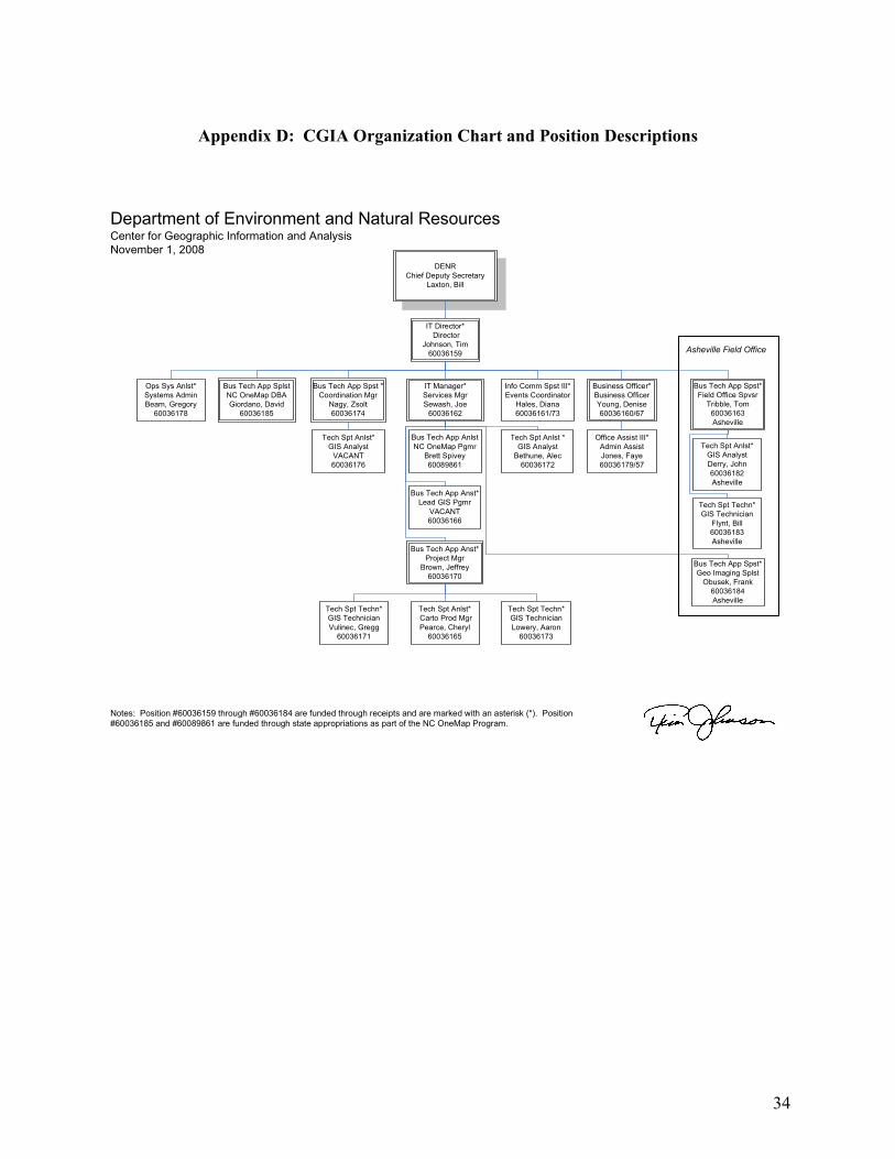
34
Appendix D: CGIA Organization Chart and Position Descriptions
IT Director*
Director
Johnson, Tim
60036159
IT Manager*
Services Mgr
Sewash, Joe
60036162
Bus Tech App Spst*
Field Office Spvsr
Tribble, Tom
60036163
Asheville
Bus Tech App Spst *
Coordination Mgr
Nagy, Zsolt
60036174
Bus Tech App Anst*
Project Mgr
Brown, Jeffrey
60036170
Business Officer*
Business Officer
Young, Denise
60036160/67
Info Comm Spst III*
Events Coordinator
Hales, Diana
60036161/73
Ops Sys Anlst*
Systems Admin
Beam, Gregory
60036178
Bus Tech App Spst*
Geo Imaging Splst
Obusek, Frank
60036184
Asheville
Tech Spt Anlst*
GIS Analyst
VACANT
60036176
Office Assist III*
Admin Assist
Jones, Faye
60036179/57
Tech Spt Anlst*
GIS Analyst
Derry, John
60036182
Asheville
Tech Spt Techn*
GIS Technician
Flynt, Bill
60036183
Asheville
Bus Tech App Anst*
Lead GIS Pgmr
VACANT
60036166
Tech Spt Anlst *
GIS Analyst
Bethune, Alec
60036172
Tech Spt Anlst*
Carto Prod Mgr
Pearce, Cheryl
60036165
Tech Spt Techn*
GIS Technician
Vulinec, Gregg
60036171
Tech Spt Techn*
GIS Technician
Lowery, Aaron
60036173
Department of Environment and Natural ResourcesCenter for Geographic Information and Analysis
November 1, 2008
Notes: Position #60036159 through #60036184 are funded through receipts and are marked with an asterisk (*). Position
#60036185 and #60089861 are funded through state appropriations as part of the NC OneMap Program.
Bus Tech App Splst
NC OneMap DBA
Giordano, David
60036185
Asheville Field Office
DENR
Chief Deputy Secretary
Laxton, Bill
Bus Tech App Anlst
NC OneMap Pgmr
Brett Spivey
60089861
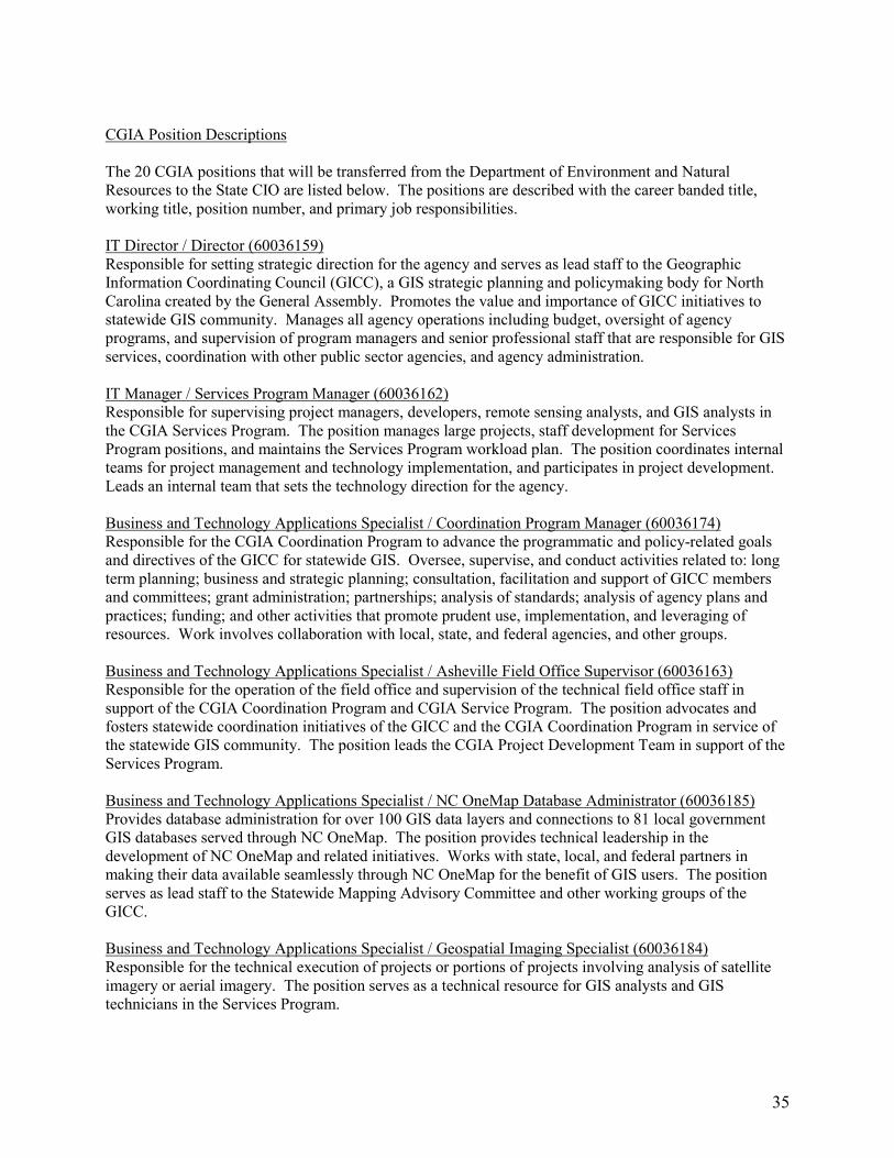
35
CGIA Position Descriptions The 20 CGIA positions that will be transferred from the Department of Environment and Natural Resources to the State CIO are listed below. The positions are described with the career banded title, working title, position number, and primary job responsibilities. IT Director / Director (60036159) Responsible for setting strategic direction for the agency and serves as lead staff to the Geographic Information Coordinating Council (GICC), a GIS strategic planning and policymaking body for North Carolina created by the General Assembly. Promotes the value and importance of GICC initiatives to statewide GIS community. Manages all agency operations including budget, oversight of agency programs, and supervision of program managers and senior professional staff that are responsible for GIS services, coordination with other public sector agencies, and agency administration. IT Manager / Services Program Manager (60036162) Responsible for supervising project managers, developers, remote sensing analysts, and GIS analysts in the CGIA Services Program. The position manages large projects, staff development for Services Program positions, and maintains the Services Program workload plan. The position coordinates internal teams for project management and technology implementation, and participates in project development. Leads an internal team that sets the technology direction for the agency. Business and Technology Applications Specialist / Coordination Program Manager (60036174) Responsible for the CGIA Coordination Program to advance the programmatic and policy-related goals and directives of the GICC for statewide GIS. Oversee, supervise, and conduct activities related to: long term planning; business and strategic planning; consultation, facilitation and support of GICC members and committees; grant administration; partnerships; analysis of standards; analysis of agency plans and practices; funding; and other activities that promote prudent use, implementation, and leveraging of resources. Work involves collaboration with local, state, and federal agencies, and other groups. Business and Technology Applications Specialist / Asheville Field Office Supervisor (60036163) Responsible for the operation of the field office and supervision of the technical field office staff in support of the CGIA Coordination Program and CGIA Service Program. The position advocates and fosters statewide coordination initiatives of the GICC and the CGIA Coordination Program in service of the statewide GIS community. The position leads the CGIA Project Development Team in support of the Services Program. Business and Technology Applications Specialist / NC OneMap Database Administrator (60036185) Provides database administration for over 100 GIS data layers and connections to 81 local government GIS databases served through NC OneMap. The position provides technical leadership in the development of NC OneMap and related initiatives. Works with state, local, and federal partners in making their data available seamlessly through NC OneMap for the benefit of GIS users. The position serves as lead staff to the Statewide Mapping Advisory Committee and other working groups of the GICC. Business and Technology Applications Specialist / Geospatial Imaging Specialist (60036184) Responsible for the technical execution of projects or portions of projects involving analysis of satellite imagery or aerial imagery. The position serves as a technical resource for GIS analysts and GIS technicians in the Services Program.
36
Business and Technology Applications Analyst / Project Manager (60036170) Responsible for supervising GIS analysts and GIS technicians in the CGIA Services Program. The position is responsible for independently managing client projects, and performing high level technical analysis. The position participates on internal teams for project development and project management. Business and Technology Applications Analyst / NC OneMap Programmer (60089861) This position provides primary support for the software infrastructure of the NC OneMap catalog and NC OneMap web mapping viewer. This position provides outreach and support to develop NC OneMap partner connections and maintain existing connections with State agencies and local governments. Business and Technology Applications Analyst / Lead GIS Programmer (60036166) This position is the lead application developer for the CGIA Services Program. This position develops and maintains internet-based GIS applications of medium to high complexity. Operations and Systems Analyst / CGIA System Administrator (60036178) Responsible for the management, maintenance, security, and upgrade of the computer systems and network. Responsible for the configuration and purchase of new equipment and software. Performs hardware diagnostics and repairs. Provides computer support for staff in CGIA Raleigh and Asheville offices and for clients. Responsible for maintaining a complete system backup. Technology Support Analyst / GIS Analyst (60036176) Provide technical support, consultation, training, and related outreach on activities to advance goals and directives for statewide GIS as part of the CGIA Coordination Program. Activities include: development, analysis, and instruction on best practices, technical plans, standards, and applications; leadership and staffing of work groups; in-depth training of a broad customer base from local and state agencies and other key members of the state GIS community; project management; and problem solving. Technology Support Analyst / GIS Analyst (60036172) This position manages small projects and components of medium and large projects with minimal supervision. This position provides advanced technical analysis and is a technical resource to other GIS analysts and GIS technicians in the Services Program. Technology Support Analyst / GIS Analyst (60036182) This position manages small projects and components of medium projects from the Asheville Field Office. The position provides maintenance support for internet-based GIS applications and provides technical analysis support for Services Program projects. Technology Support Analyst / GIS Analyst (60036165) This position is the primary lead for project involving cartographic design and production. The position provides analytical support for projects, and is a technical resource for GIS analysts and GIS technicians. Technology Support Technician / GIS Technician (60036173) This position participates in Services Program projects to support GIS analysis, quality control, and data management activities. Technology Support Technician / GIS Technician (60036171) This position participates in Services Program projects to support GIS analysis, quality control, and data management activities.
37
Technology Support Technician / GIS Technician (60036183) This position participates in Services Program projects to support GIS analysis, quality control, and data management activities in the Asheville Field Office. Information and Communications Specialist III / Events Coordinator (60036161) Provides staff support to the GICC and responsible for meeting logistics, writing Minutes and Annual Report, website content and support of standing committee assignments. Plans and coordinates the large biennial statewide North Carolina GIS Conference and organizes an annual GIS Day celebration on behalf of the GICC. Maintains online inventories and promotes the GICC and CGIA through articles and listserv messages. Responds to special project requests as they arise. Business Officer / Business Officer (60036160) This position is responsible for administering and managing CGIA business and financial operations. Position performs all billing and collections for CGIA services, and manages budgets in consultation with Director. This position serves as human resources manager for CGIA and directly supports supervisors with staff recruitment, selection and personnel administration processes. This position also has responsibilities related to contract/grant administration, purchasing, fixed assets and safety. Office Assistant III / Administrative Assistant (60036179) This position is responsible for administrative, secretarial and office support duties. This position is responsible for answering the phone and fielding questions and directing them appropriately. The position is also responsible for accounts payable, receivables, travel arrangements, expense reports, filing, and mail for the agency. The position provides administrative support to the Business Officer and Director.

38
Appendix E: CGIA Position Costs

39
Appendix F: CGIA Fixed Assets Inventory