Embed Size (px)
Citation preview
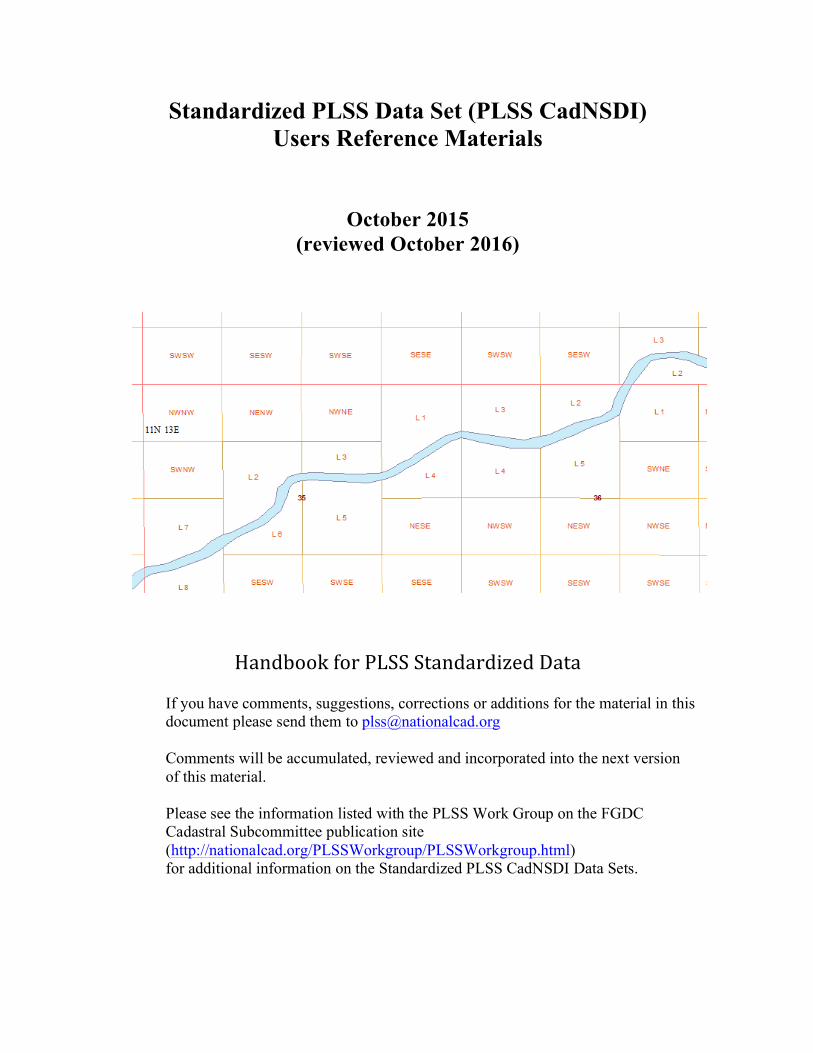
Standardized PLSS Data Set (PLSS CadNSDI) Users Reference Materials
October 2015 (reviewed October 2016)
HandbookforPLSSStandardizedData
If you have comments, suggestions, corrections or additions for the material in this document please send them to [email protected] Comments will be accumulated, reviewed and incorporated into the next version of this material. Please see the information listed with the PLSS Work Group on the FGDC Cadastral Subcommittee publication site (http://nationalcad.org/PLSSWorkgroup/PLSSWorkgroup.html) for additional information on the Standardized PLSS CadNSDI Data Sets.
Handbook for Standardized PLSS CadNSDI Data
ii
Table of Contents Introduction ....................................................................................................................... 1Frequently Asked Questions ............................................................................................. 2
General Questions ........................................................................................................... 2Conflicted Areas - How should a GISer work around conflicted areas? ........................ 6Survey System and Parcel Feature Classes - The feature classes "Survey System" and “Parcel” do not have any data in them, why is this? ...................................................... 6PLSS Township ................................................................................................................ 7Metadata at a Glance ...................................................................................................... 7
GIS Quick Start ................................................................................................................. 8Starting Layers ................................................................................................................ 8Other Layers .................................................................................................................. 14Acreages in PLSS CadNSDI .......................................................................................... 14
Key Concepts and Definitions ........................................................................................ 15The Public Land Survey System (PLSS) concepts and terms ........................................ 15Manual of Instructions 2009 ......................................................................................... 15Production, Publication and Project Data .................................................................... 16
Standards .......................................................................................................................... 16Cadastral Data Content Standard ................................................................................. 17PLSS – BLM Point ID Standard (2006) ........................................................................ 17
Production – Operation and Maintenance .................................................................... 18BLM GCDB ..................................................................... Error! Bookmark not defined.GCDB Users Guide ......................................................... Error! Bookmark not defined.
Application of Concepts to the Standardized Data ...................................................... 19Rectangular versus non-Rectangular ............................................................................ 19Nominal Locations ......................................................................................................... 23Segregated Surveys and Lotting .................................................................................... 23
CADNSDI Description .................................................................................................... 25Overview – Versions Revision Vintage .......................................................................... 25Overview Data Structure ............................................................................................... 26Feature Classes in Cadastral Reference ....................................................................... 29
Appendix A - Acronyms and Abbreviations ................................................................. 32Appendix B - Standard Domains for PLSS CadNSDI ................................................. 33Appendix C - Feature Class Details ............................................................................... 42
Handbook for Standardized PLSS CadNSDI Data
iii
List of Figures
Figure1-PLSSTownshipOutlineswithLabels.....................................................................................................................8Figure2-PLSSFirstDivisionOutlinewithLabels................................................................................................................9Figure3-PLSSTownshipOutlinesSymbolizedbySRVTYP..........................................................................................10Figure4-FirstDivisionOutlinesSymbolizedbyFRSTDIVTYP....................................................................................10Figure5-PLSSTownshipwithFirstandSecondDivisionOutlines...........................................................................11Figure6-ZoomedinViewofFigure5....................................................................................................................................11Figure7-ArcMapTableofContents.......................................................................................................................................12Figure8-SectionDividedintoLots..........................................................................................................................................13Figure9-MeanderedWaterwithPLSSRectangularFeatures...................................................................................13Figure10-Apparent"Hole"isRectangularPLSS..............................................................................................................21Figure11-SpecialSurveysinApparentPLSS"hole".......................................................................................................21Figure12-MeanderedWaterBody.........................................................................................................................................22Figure13-LottingAroundTracts………………………………………………………………………………………………………23Figure14-Non-SegregationLottinginaPLSSTownship.............................................................................................24Figure15-MetadataGlanceSymbolizedbyDataSteward...........................................................................................27
Figures in the appendix are included in this list
Handbook for Standardized PLSS CadNSDI Data
1
Introduction This document provides supporting documentation for the Public Land Survey System (PLSS) standardized data for the Cadastral National Spatial Data Infrastructure (PLSS CadNSDI) data set. The Frequently Asked Question (FAQ) section provides responses to questions most asked by those generally familiar with the PLSS and are starting to use this data set for the PLSS representation in a Geographic Information System (GIS). The Key Concepts and Definitions section provides links to source documents that provide additional detail and background on key terms and concepts related to the PLSS, cadastral data, related data standards and the specific procedures and processes used in the Bureau of Land Management (BLM) Cadastral Survey to develop coordinate positions on PLSS corners. Application of Concepts to the Standardized Data section is an overview of some of the key concepts of the PLSS and their manifestation in the standard. This section provides a layman’s description of some of the idiosyncrasies of the PLSS. The PLSS CadNSDI Description section describes the specific content of the PLSS CadNSDI data set. This is the data dictionary for the standard. Appendix A is a list of acronyms. Appendix B is a description of some of the more common anomalies in the PLSS data. Throughout this document the Feature Class names are in italics. Field names (attributes) are in CAPITOL letters. ArcMap is the Esri mapping software used by the BLM and is the software used in the implementation of this data set. The Parcel Fabric is a data editing and maintenance tool that is a part of the Esri ArcMap solution. The Parcel Fabric is the tool set used by the BLM to maintain the PLSS CadNSDI. Updated data sets are published form the Parcel Fabric.
Handbook for Standardized PLSS CadNSDI Data
2
Frequently Asked Questions These answers are intended to give the users that are generally familiar with the data a quick start to using the data.
General Questions What is NSDI?
The NSDI1 is the National Spatial Data Infrastructure, which has been defined as the framework data sets that provide a basis to support decision-making and encourage the broad use of geographic information. The goal of this Infrastructure is to reduce duplication of effort among agencies, improve quality and reduce costs related to geographic information, to make geographic data more accessible to the public, to increase the benefits of using available data, and to establish key partnerships with states, counties, cities, tribal nations, academia and the private sector to increase data availability. The Cadastral components of the NSDI, sometimes called the CadNSDI, are the core or essential elements of cadastral information that provide the framework for building and using cadastral (land records) information nationwide. The PLSS CadNSDI is the Public land Survey System (PLSS) cadastral reference components of the Cadastral data. In addition to cadastral reference data there are parcel data and rights and interest data. This document and these guidelines in this document cover only the PLSS CadNSDI.
What is Version 2 and Vintage? The Federal Geographic Data Committee (FGDC) Cadastral Subcommittee has published an updated version of the publication guidelines for the standardized PLSS CadNSDI data sets. Version 2 represents updates to the formats, attribution, and definitions of features. Within the standardized data sets, the data stewards will update the data content. This changing data set is termed a change in the Vintage, or the age or revision data but is not a change in the version. The term version is meant to reflect the format and structure of the data and vintage is used to describe the age or revision of the data. The Version 2 format is a suggested minimum and data stewards may add fields to the core standard. This is expected and is in line with the expectation of the use of the standard.
How was the data compiled?
The original PLSS data content in the standardized PLSS CadNSDI data set was developed by identified data stewards, who are recognized agencies that have the authority to develop and maintain cadastral information, using the best available information. This is typically survey data, control observations, and supplemental measurements. In the Bureau of Land Management (BLM) Cadastral Survey the Geographic Coordinate Database (GCDB) program has compiled the information typically using the GCDB Geographic Measurement Management (GMM) software tools.
1 This is the web site for the Federal Geographic Data Committee that explains the background and authority for the National Spatial Data Infrastructure http://www.fgdc.gov/nsdi/nsdi.html last access April 2011
Handbook for Standardized PLSS CadNSDI Data
3
In some cases survey information has not been completely abstracted or is not available and in these cases non-GCDB sourced data such as digitized maps or data from other sources have been used. In all cases the data steward is identified in the data sets and in the metadata records. In the eastern US, generally in states where the PLSS is closed, i.e. the notes and plats have been turned over to the states, the basis of the PLSS was state provided data sets with the goal of capturing the best available statewide coverage. In many cases this is section level data compiled from topographic quads with a mix of updated information from local governments and federal land areas, such as fish and wildlife and forest service lands.
Is there any difference between legal record and the PLSS CadNSDI? Yes, the source documents or records that are used to develop the information contained in the PLSS CadNSDI that originates from the BLM GCDB program are based on an authoritative source. But, the PLSS CadNSDI is not intended to be a legally binding source. Any legal decisions will need to refer to the most authoritative record, such as the survey plat and notes. The PLSS CadNSDI features are the best available representation of the Cadastral Records for use in GIS applications, but in some cases there may be nuanced differences due to complexity in the cadastral records or incomplete abstraction of data from surveys and records.
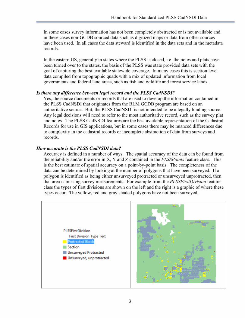
How accurate is the PLSS CadNSDI data? Accuracy is defined in a number of ways. The spatial accuracy of the data can be found from the reliability and/or the error in X, Y and Z contained in the PLSSPoints feature class. This is the best estimate of spatial accuracy on a point-by-point basis. The completeness of the data can be determined by looking at the number of polygons that have been surveyed. If a polygon is identified as being either unsurveyed protracted or unsurveyed unprotracted, then that area is missing survey measurements. For example from the PLSSFirstDivision feature class the types of first divisions are shown on the left and the right is a graphic of where these types occur. The yellow, red and gray shaded polygons have not been surveyed.

Handbook for Standardized PLSS CadNSDI Data
4
There are also cases where data has not been completely abstracted from survey plats and notes due to the complexity of the data, but the data stewards are continually updating the PLSS CadNSDI. The third type of accuracy is the attribute consistency and accuracy. The PLSS CadNSDI has been through a series of quality checks to catch as many potential coding errors as possible. Each data set varies but in general the attribute accuracy is approaching 99% for most of the data sets.
Why does the geometry stored in the derivative feature classes appear to be incorrect? In GCDB, attribution is assigned to the parcels in the GMM process. If attributes are incorrectly assigned to the parcel, then the incorrect attributes will perpetuate throughout the derivative datasets. The data stewards are most likely aware of these issues and will address them in ongoing maintenance. The image below represents parcels in the PLSSTownship feature class that are actually coded incorrectly in the PLSSIntersected feature class, but perpetuated into the PLSS Township layer. As these errors are found they are being corrected. These errors should be reported to the data steward.
How up to date is the data and when does the database get updated? The last revised date, which can be found in the MetadataGlance feature class and in individual polygons in the PLSSIntersected feature class indicate when the data was revised. The publication date in the metadata will indicate the most recent publication date for the entire data set.
Handbook for Standardized PLSS CadNSDI Data
5
Is the BLM responsible for all of the data even though some of it comes from other federal agencies?
The data steward will indicate the authoritative source for the data. Typically the agency that provided the source data is also the agency responsible for updates. The BLM has combined the data from multiple sources into a single data set for convenience of use and access. As the PLSS CadNSDI develops it is expected that other federal agencies such as the Forest Service may assume data stewardship for PLSS CadNSDI in areas where Forest Service manages the surface rights and counties or states will assume updates on privately held lands. The best approach is to contact the identified data steward.
If errors are found how should I go about getting the data corrected? The data stewards should be contacted if errors are found in the data. The first resource should be the data contact identified in the metadata.
The naming convention is confusing; can we simplify? Can we create GIS friendly attributes and maybe eliminate some attributes that GIS doesn’t use?
The naming convention reflects the national Cadastral Data Content Standard. The alias names provide more user-friendly attribute names. Within a local copy of the data set the GIS user could change the alias names. If there is a particular naming convention that is causing concern this might be a solution, but as the GIS person works with the data, they will become more familiar with the naming conventions provided in the standard. The full PLSS data set has many nuances and subtleties and the naming conventions used in the standard acknowledge these characteristics rather than to simplify the data set and lose some of these important distinctions. The GIS user can certainly ignore attributes that do not apply to their situation. GIS users could make a copy of the data and delete attributes. However this is not recommended because keeping the copies of data synchronized with the authoritative sources could be difficult. The use of attributes might be an issue of familiarity and we have found as people work with the data the naming convention and attribution begins to make sense.
Which feature class to use? Do GISers really need all of these feature classes? This depends on your applications. The components of the PLSS have been broken out to allow the GIS user to set scale extents, to add only the data they need and to support symbolization. The data sets can be exported as layer files to simplify use. Cadastral data is a complicated data theme and the nuances of the content need to be acknowledged. There is supporting educational material available to help the GIS user understand what layers are needed for specific applications. It is not recommended that the casual user take on the PLSS Intersected feature class. This is the atomic feature class that is similar in some ways to the formerly used Arc Info coverages. The dependent themes are built from the PLSSIntersected using many rules for combining and building the dependent data sets. In one sense the derived feature classes are similar to regions that were used with coverages in earlier version of Arc Info.
Handbook for Standardized PLSS CadNSDI Data
6
Where can I find historic survey information that is not contained in the PLSS Second Division or PLSS Special Survey feature class?
It is common for BLM to conduct cadastral resurveys of land for a number of reasons. Resurveys can cause issues in the way legal descriptions have historically been captured. For example, the original survey of the Northeast ¼ of the Northeast ¼ of Section 1 may have been described as Government Lot 1. A resurvey of that section could change the bearings and distances as well as acreage for Lot 1. The resurvey would then officially rename Lot 1 to Lot 5 and provide the updated acreage for Lot 5. In GCDB, Lot 1 is now considered Historic or Replaced and Lot 5 is the official parcel. The historic or replaced parcels are stored in the PLSS Intersected Feature Class as “stacked polygons”, along with the official or current parcel and has a survey note of R indicating that the original land description has been replaced. The current polygon is the only polygon that should be used in the derivative feature classes (ie PLSSFirstDivision, PLSSSecondDivision, and PLSSSpecialSurvey feature classes.)
Conflicted Areas - How should a GISer work around conflicted areas? The conflicted areas are presented so the GIS user knows that some areas are unresolved in the actual survey data. There is not a work around for the conflicted areas which is why they are included in the data set. For some general applications perhaps conflicted areas can be ignored such as for indexing or symbolization. This may be expedient but the GIS User needs to understand the potential risks of oversimplifying the information by neglecting the conflicted areas.
Survey System and Parcel Feature Classes - The feature classes "Survey System" and “Parcel” do not have any data in them, why is this?
The Survey System represents lands that are a cadastral reference feature but are not in the public lands. These could be lands that were settled and patented prior to survey. The PLSS CadNSDI in the western states is based primarily on BLM records. The Survey System and Survey System Division feature classes are primarily for non-federal agencies and they contain the data for lands that were never in the Public Land Survey System or for lands where survey subdivisions have superseded the PLSS as a Cadastral Reference. These are essential as reference data for non-BLM data sets and for non-federally maintained Cadastral Reference data. In Ohio and many eastern states the lands that were settled prior to the Public Land Survey or lands that had prior claims will be defined in the Survey System feature classes. Parcel core data does exist for many counties in the United States, but parcels are not something the federal government has focused on or addressed. There is a working group developing federal parcel content standards that will eventually, presumably, populate federal parcels in the NSDICoreParcel feature class. Because these feature classes do not have data, in some cases they may not have a defined spatial extent that can cause an error in ArcMap when adding these features to your canvas. Just remove these feature classes from your canvas.
Handbook for Standardized PLSS CadNSDI Data
7
PLSS Township Can a GIS User update the labels? For example, in the PLSS Township feature class could the labels be updated to include a "T" and an "R" and also zeros. For example, if a record's label is "15N 7W", can it be "T15N-R07W"?
The structure and format of the label field is not specified in the national standard. The convention that is included in the CADNSDI data set was agreed upon several years ago. If the GIS person would like to update or change the content or structure of the label field this can be done in the data or it can be done through the map labels. The map labels will easily build this label because all of the components are in the data set and then the user can set the scale dependencies and symbol set. The resulting labels could also be exported to an annotation feature class.
Why is the PLSS Township number three digits?
The three-digit township and range is necessary of a national standard. However counties and states that only have two digit township and range numbers and do not want to have the three-digit field with the leading zeros have several options. (1) truncate the township and range numbers in the label field, (2) construct a query for a map label that will eliminate the leading zeros, (3) export the labels to an annotation feature class that can be managed independently or linked to the source field, or (4) add another field to the local data set that has a field length of 2 for the township and range numbers.
Metadata at a Glance What is MetadataGlance feature class?
The MetadataGlance feature class represents areas of data stewardship. As data stewardship advances, the Metadata at a Glance will eventually deviate from the PLSSTownship feature class as stewardship areas become more refined and are defined below the PLSS Township level. In some states for example, the county manages half of the township and half is managed by the BLM. In that case the metadata at a glance will have two polygons for the MetadataGlance and the PLSSTownship will have one polygon. In this case the Stewardship polygon will be defined with a stewardship identifier, the type of stewardship polygon, such a partial PLSS Township, and a label. This feature class is also useful for symbolizing the last revised date of data sets as the data are incrementally updated.
Handbook for Standardized PLSS CadNSDI Data
8
GIS Quick Start There are quite a few nuances in this data set. On the face of it the PLSS appears to be a simple system of Townships and Sections dividing the 30 states it covers into six-by-six mile townships with 36 square mile square sections, the actual system on the ground bears only a passing resemblance to this idea. However a few starting tips make it easier to get the GIS users up and running.
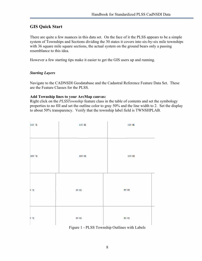
Starting Layers Navigate to the CADNSDI Geodatabase and the Cadastral Reference Feature Data Set. These are the Feature Classes for the PLSS. Add Township lines to your ArcMap canvas: Right click on the PLSSTownship feature class in the table of contents and set the symbology properties to no fill and set the outline color to gray 50% and the line width to 2. Set the display to about 50% transparency. Verify that the township label field is TWNSHPLAB.
Figure 1 - PLSS Township Outlines with Labels
Handbook for Standardized PLSS CadNSDI Data
9
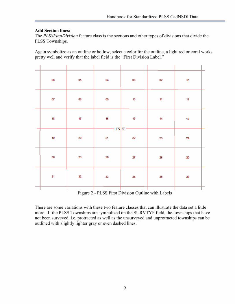
Add Section lines: The PLSSFirstDivision feature class is the sections and other types of divisions that divide the PLSS Townships. Again symbolize as an outline or hollow, select a color for the outline, a light red or coral works pretty well and verify that the label field is the “First Division Label.”
Figure 2 - PLSS First Division Outline with Labels
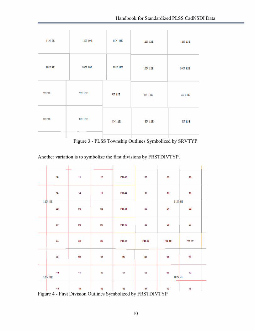
There are some variations with these two feature classes that can illustrate the data set a little more. If the PLSS Townships are symbolized on the SURVTYP field, the townships that have not been surveyed, i.e. protracted as well as the unsurveyed and unprotracted townships can be outlined with slightly lighter gray or even dashed lines.
Handbook for Standardized PLSS CadNSDI Data
10
Figure 3 - PLSS Township Outlines Symbolized by SRVTYP
Another variation is to symbolize the first divisions by FRSTDIVTYP.
Figure 4 - First Division Outlines Symbolized by FRSTDIVTYP
Handbook for Standardized PLSS CadNSDI Data
11
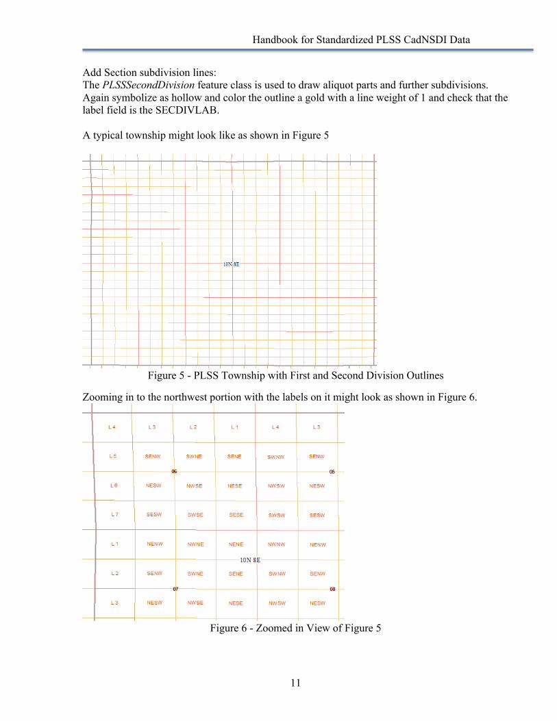
Add Section subdivision lines: The PLSSSecondDivision feature class is used to draw aliquot parts and further subdivisions. Again symbolize as hollow and color the outline a gold with a line weight of 1 and check that the label field is the SECDIVLAB. A typical township might look like as shown in Figure 5
Figure 5 - PLSS Township with First and Second Division Outlines
Zooming in to the northwest portion with the labels on it might look as shown in Figure 6.
Figure 6 - Zoomed in View of Figure 5
Handbook for Standardized PLSS CadNSDI Data
12
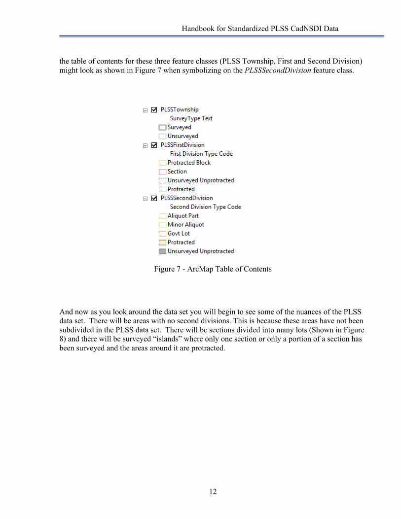
the table of contents for these three feature classes (PLSS Township, First and Second Division) might look as shown in Figure 7 when symbolizing on the PLSSSecondDivision feature class.
Figure 7 - ArcMap Table of Contents
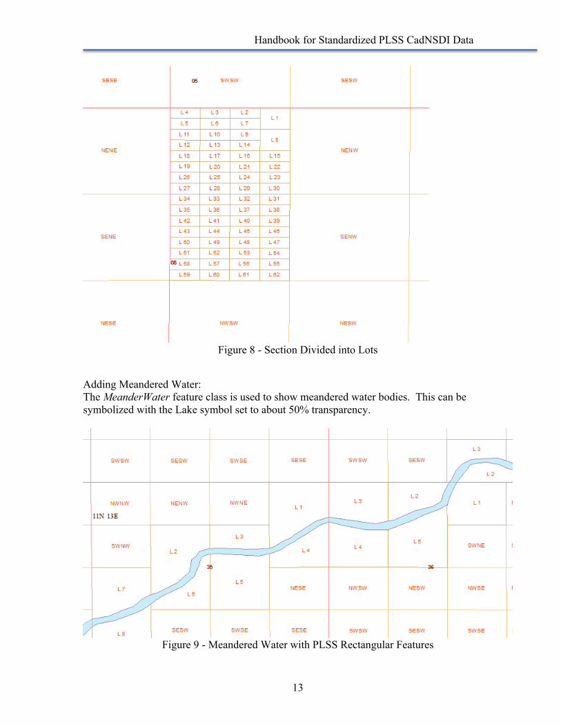
And now as you look around the data set you will begin to see some of the nuances of the PLSS data set. There will be areas with no second divisions. This is because these areas have not been subdivided in the PLSS data set. There will be sections divided into many lots (Shown in Figure 8) and there will be surveyed “islands” where only one section or only a portion of a section has been surveyed and the areas around it are protracted.
Handbook for Standardized PLSS CadNSDI Data
13
Figure 8 - Section Divided into Lots
Adding Meandered Water: The MeanderWater feature class is used to show meandered water bodies. This can be symbolized with the Lake symbol set to about 50% transparency.
Figure 9 - Meandered Water with PLSS Rectangular Features
Handbook for Standardized PLSS CadNSDI Data
14
Other Layers The PLSSSpecialSurvey feature class is the next feature class to add and again it can be symbolized according to the survey type, it might be hollow to illustrate the overlapping special surveys or it might be a transparent fill. There are many display options as other feature classes are added depending on the project or map requirements.
Acreages in PLSS CadNSDI The PLSS CadNSDI data computed from BLM records may continue to reflect attribution in some of the BLM legacy systems and this apparent in some of the acreage information. For example, if a mineral survey (a BLM Special Survey) has not been abstracted and then entered into the BLM computational programs, it is represented according to the rectangular 1/16th aliquot part where the mineral survey is thought to exist. In these cases the mineral survey may be identified as containing 40 acres even though the record acreage will be much less than this. There may also be residual conditions where the BLM records had split rectangular and special surveys with “geopolitical” lines, typically representing county boundary lines. These “geopolitical splits” are being removed as data is updated but there may be areas where the PLSS Intersected still contains unexpected acreages for polygons. In version 2 of the PLSS CadNSDI a field for GIS Acre has been added. This is a computed field and is NOT the record acres for the polygon. The BLM standard projection for acres is Contiguous Albers Equal Area Conic projection. Another projection may produce a different GIS Acre value.
Handbook for Standardized PLSS CadNSDI Data
15
Key Concepts and Definitions
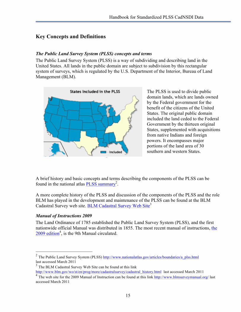
The Public Land Survey System (PLSS) concepts and terms The Public Land Survey System (PLSS) is a way of subdividing and describing land in the United States. All lands in the public domain are subject to subdivision by this rectangular system of surveys, which is regulated by the U.S. Department of the Interior, Bureau of Land Management (BLM).
The PLSS is used to divide public domain lands, which are lands owned by the Federal government for the benefit of the citizens of the United States. The original public domain included the land ceded to the Federal Government by the thirteen original States, supplemented with acquisitions from native Indians and foreign powers. It encompasses major portions of the land area of 30 southern and western States.
A brief history and basic concepts and terms describing the components of the PLSS can be found in the national atlas PLSS summary2. A more complete history of the PLSS and discussion of the components of the PLSS and the role BLM has played in the development and maintenance of the PLSS can be found at the BLM Cadastral Survey web site. BLM Cadastral Survey Web Site3
Manual of Instructions 2009 The Land Ordinance of 1785 established the Public Land Survey System (PLSS), and the first nationwide official Manual was distributed in 1855. The most recent manual of instructions, the 2009 edition4, is the 9th Manual circulated.
2 The Public Land Survey System (PLSS) http://www.nationalatlas.gov/articles/boundaries/a_plss.html last accessed March 2011 3 The BLM Cadastral Survey Web Site can be found at this link http://www.blm.gov/wo/st/en/prog/more/cadastralsurvey/cadastral_history.html last accessed March 2011 4 The web site for the 2009 Manual of Instruction can be found at this link http://www.blmsurveymanual.org/ last accessed March 2011
Handbook for Standardized PLSS CadNSDI Data
16
The Manual has guided the original surveys and resurveys of the Public Lands, first through the General Land Office, and since 1946, through the Bureau of Land Management, Department of the Interior. While not written specifically for non-Federal surveyors, the principles contained in the Manual on the subject of retracement are an integral part of private surveying in the 30 Public Land States. Further, many States have formally adopted the Manual in statute, rule, and/or case law as guidance for private licensed surveyors. Thus, the book is a fundamental piece of the complex subject of boundary surveys here in the United States. Authority and Authoritative Sources (2008) Authoritative and Trusted Sources5 are terms used with cadastral data. Because of the legal issues related to ownership and rights in land, the use of the terms authority and authoritative for cadastral data need to be clearly articulated. Similarly the term trusted source defines an Internet publication source for cadastral data that is recognized and acknowledged by the authoritative source of the data. The vision for the National Spatial Data Infrastructure (NSDI) and the Cadastral data within the NSDI is to have local sources of authoritative cadastral data that is controlled and managed by designated data stewards 6. Data stewardship for parcel data is similar to that for PLSS data and was documented in 2007 in a paper on State Parcel Stewardship7. Data Aggregators or Integrators compile and combine the data as a trusted source at state or regional levels to facilitate access to the data.
Production, Publication and Project Data The different types of GIS data include Production, Publication and Project Data8. When users and producers are discussing sharing data these concepts can cause considerable confusion. Production Data is the “master” database that is managed by the data steward for their daily business operations, maintenance and updates; Publication Data is a subset of the Production Data, it is designed to meet 95% of the user community needs, it is structured to support consumer and business needs and is not intended to support maintenance operations; Project Data, as the term implies, is additional information needed for a “project” that includes a specific data requests identified from the publication data. Requests for project data are directed to the data steward.
Standards The Federal Geographic Data Committee (FGDC) Subcommittee on Cadastral Data (Subcommittee) has developed content and implementation standards for the PLSS. The Subcommittee’s standards can be divided into production and publication standards. The
5 FGDC Cadastral Data Subcommittee, Authority and Authoritative Sources: Clarification of Terms and Concepts for Cadastral Data, August 2008, http://nationalcad.org/download/Authority-and-Authoritative-Sources-Final.pdf, last accessed February 2017 6 FGDC Cadastral Data Subcommittee, PLSS Stewardship, December 2010, http://nationalcad.org/download/PLSS_Stewardship.pdf, last accessed February 2017 7 FGDC State Stewardship for Parcel Data, http://nationalcad.org/download/StateStewardshipCadastralDataSetsSep2007.pdf, last accessed February 2017 8 FGDC Cadastral Data Subcommittee, Parcel Data: Production, Publication and Project Data, Internet, 2008, http://nationalcad.org/download/pub-prod.pdf, last accessed February 2017

Handbook for Standardized PLSS CadNSDI Data
17
Cadastral Data Content Standard is the production standard while the remaining standards are focused on standards for publication. The BLM Point ID Standard is critical for allowing users to uniquely identify corners in the Public Land Survey System (PLSS) and to share this data. The Cadastral NSDI Reference Document describes the publication standard for both the PLSS and parcels. It was found that the user community was usually concerned with either the PLSS or parcels but not both so two documents are being developed, the Cadastral NSDI Reference for Core Parcel Data was written to describe the parcel data publication standard and the Cadastral NSDI Reference for Corners of Common Control is a work in progress.
Cadastral Data Content Standard The FGDC Standard Reference Model, Cadastral Data Content Standard for the National Spatial Data Infrastructure, Version 1.4, Third Revision9, (Content Standard) was created to address all conditions for surface and subsurface rights and interests in the United States. The target audiences for the Content Standard are database managers, system developers and designers. The format of the standard (semantic definitions), which is dictated by the FGDC Subcommittee standards process, can be daunting to read. Normally such a database is better expressed in terms of an entity relationship diagram. The Florida Department of Revenue’s Florida Parcel Data Model is one example of the standard that is in this more familiar format, and many other states also parcel standards. A listing of standards can be found on at (http://nationalcad.org/RefDocStand/RefDocStand.html).
PLSS – BLM Point ID Standard (2006) The standardized data includes a consistent and standardized method for identifying corner features following the BLM Corner ID Standard10. The publication of corners with this ID supports the Cadastral NSDI development and enhances data sharing and data integration. The Wisconsin Corner Point Identification System 11 provides an example a state implementation of a unique corner identification system that is consistent with the principles of the data content standard but differ from the BLM’s implementation.
9 FGDC Cadastral Data Subcommittee, Cadastral Data Content Standard for the National Spatial Data Infrastructure, Version 1.4, Third Revision, Internet, May 2008, http://nationalcad.org/download/cadastral-data-content-standard-ver-1-4.pdf, last accessed February 2017 10 Bureau of Land Management, Geographic Coordinate Database (GCDB), Publication Point ID’s, FGDC Cadastral Data Subcommittee, Internet, http://nationalcad.org/download/BLM-PointID-standard-summary.pdf, last accessed February 2017 11 Wisconsin Corner Point Identification System, Wisconsin Society of Land Surveyors, Mike Romportl, 2006, http://wsls.org/images/WSLS/WCSA/pubs/Wisconsin-Corner-Point-Identification-System-jan06.pdf, last accessed February 2017
Handbook for Standardized PLSS CadNSDI Data
18
Production – Operation and Maintenance The procedures for data creation and maintenance vary among the data stewards. The publication format described in the PLSS CadNSDI is an effort to standardize the information produced by many data stewards into a national standard format that can be consumed by all users. Much of the data for the PLSS CadNSDI originate from the BLM Cadastral Survey. BLM uses the Esri Parcel Fabric tools to maintain the data for publishing to the PLSS CadNSDI. This article provides some background on the migration effort to the Esri tool sets. https://medium.com/@Esri/bureau-of-land-management-cadastral-survey-adopts-esri-s-parcel-fabric-51ff44bb87af#.nakfbzafi BLM has published its training materials related to the use of the Esri parcel fabric on You Tube. There is a CadNSDI You Tube channel that can be found here https://www.youtube.com/channel/UChbhzk0rupEms6zHJehdFyg The implementation guidelines including information on coding domains and documentation for production operations are posted to this nationalcad web page and http://nationalcad.org/CadStandContent/CadStandContent.html (last accessed February 2017). Implementation decisions and coding examples are updated periodically on this page.
Handbook for Standardized PLSS CadNSDI Data
19
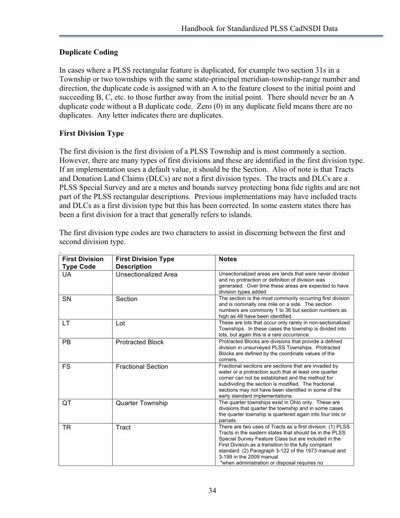
Application of Concepts to the Standardized Data The PLSS may appear to be a relatively simple system of hierarchical squares but in fact it is a very complex and highly variable system. For every rule there are a myriad of exceptions. For example the simple fact that all PLSS Townships are defined as being north or south of a baseline is not even universally true as there are many PLSS Townships that are referenced East and West. One of the most common misconceptions about the PLSS is that it covers all thirty states with a continuous and uniform grid of six-mile squares that are then further divided into one-mile squares. This couldn’t be further from reality. The PLSS is NOT a mathematical system, it is a legal land division that is defined by corners on the ground that were established according to sets of instructions to surveyors that evolved over time. The “rules of engagement” for land surveyors establishing the PLSS changed as the PLSS evolved. What was true in one area may be different in another. The following sections describe how this highly nuanced data has been developed into a standard data set and explains some of the reasons why the feature classes are defined as they are. The four most asked about topic areas are described in this section. If an apparently unusual situation exists in the standardized data set, ask the data steward identified in the data set before presuming the anomaly is an error.
Rectangular versus non-Rectangular The PLSS is not all rectangular. There are important components of the PLSS that are irregular or non-rectangular. The rectangular PLSS is a simultaneous land description meaning that all of the lands covered by a rectangular survey were described in one survey and all of the lands within that described area of equal standing, meaning there are no junior or senior rights. The condition is commonly called a simultaneous conveyance in the parlance of land surveyors but it isn’t a conveyance as much as it is a land description. The elements of the rectangular PLSS are described in Chapter 3 of the 2009 BLM Manual of Instructions12. These are surveys where the PLSS contains elements that are defined with the nested hierarchy. An irregularly shaped PLSS Township, fractional townships and half townships are all rectangular surveys. Another important characteristic of rectangular surveys is that lost corners can be re-established using proportionate measures. This is because of the simultaneous nature of the land description and is similar to what happens with lot and block corners in an urban subdivision.
12 The BLM 2009 Manual of Instructions is available in digital form https://www.blm.gov/style/medialib/blm/wo/MINERALS__REALTY__AND_RESOURCE_PROTECTION_/W0350/cadastral_pdfs/Next_Edition_Manual.Par.53033.File.dat/ManualOfSurveyingInstructions2009ElectronicUnofficialAndSubjectToChnageOrCorrection060414.pdf, last accessed February 2017
Handbook for Standardized PLSS CadNSDI Data
20
Non-rectangular PLSS surveys are called special surveys. They are described in Chapter 10 of the BLM Manual of Instructions, 2009 edition.
10-1 Special surveys are surveys that involve unusual applications of or departures from the rectangular system. They often carry out the provisions of a special legislative act. A particular category of special surveys focuses on various types of water boundaries. In some cases, the special instructions merely expand the methods outlined in chapter III. In more complicated special surveys, the methods must be carefully detailed.
The following discussion illustrates what is to be emphasized in the special instructions for each type of special survey. Tracts, Lots, and Parcels 10-2 Special surveys may involve areas of land that are not aliquot parts of sections but are designated as tracts, lots, or parcels. In common usage, the term "tract" is applied to an expanse of land of no particular size, often irregular in form. In modern Federal land surveys, the term is used specifically to mean an expanse of land that lies in more than one section or that cannot be identified in whole as a part of a particular section. It is properly described by tract number and township. Tracts within a township are numbered beginning with 37 or the next highest unused numerical designation to avoid confusion with section numbers. Tracts that have been segregated in the course of an independent resurvey are treated as described under that subject.13
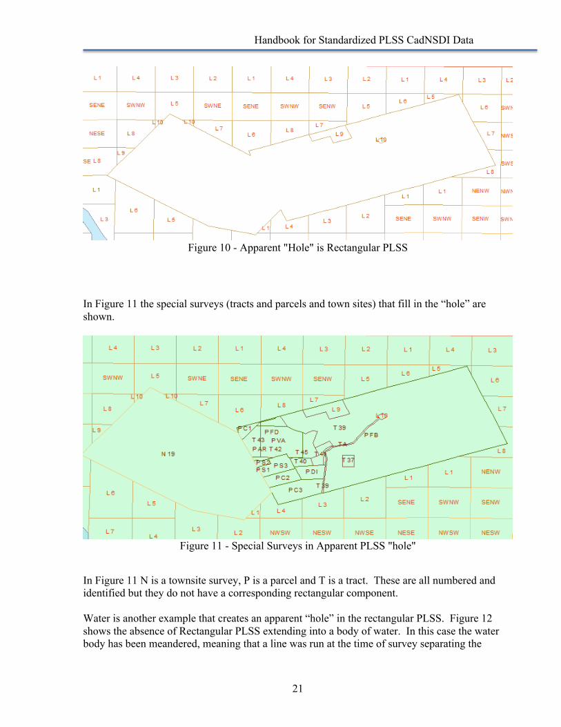
In this section the Manual of Instructions is indicating that special surveys are created when it is necessary to protect an existing interest or pre-existing condition, when particular rights or interests have been designated by legislation and require a special surveying method or to separate federal interests from private or other non-federal interests. In most cases the special surveys create “holes” in the rectangular data. That is, in areas where a special survey is created the underlying rectangular information is either no longer valid or never existed. There are some exceptions, as there are with all things cadastral. In Figure 10 there is an apparent “hole” in the rectangular survey. This is an area where special surveys were conducted to protect pre-existing private interests. These may have been settlements or claims that existed prior to survey or interests that were conveyed using rectangular surveys that were vacated and the subsequent corrected rectangular survey protected the pre-existing rights and interests.
13 IBID – Chapter 10
Handbook for Standardized PLSS CadNSDI Data
21
Figure 10 - Apparent "Hole" is Rectangular PLSS
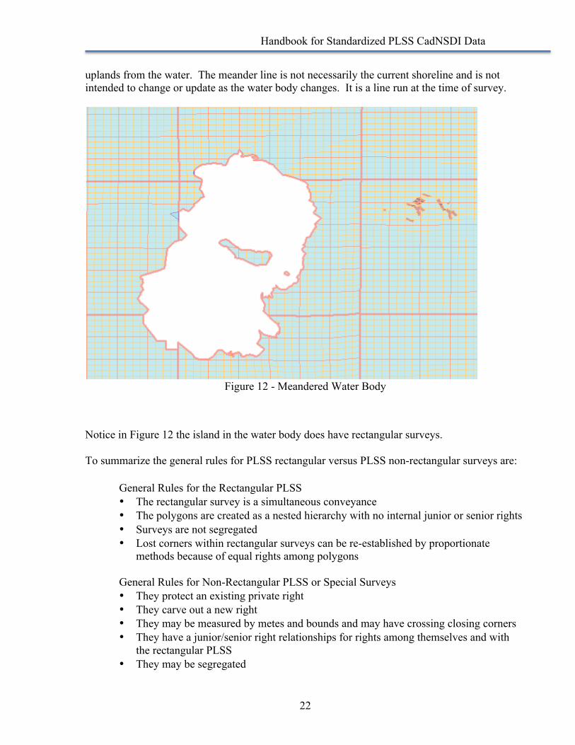
In Figure 11 the special surveys (tracts and parcels and town sites) that fill in the “hole” are shown.
Figure 11 - Special Surveys in Apparent PLSS "hole"
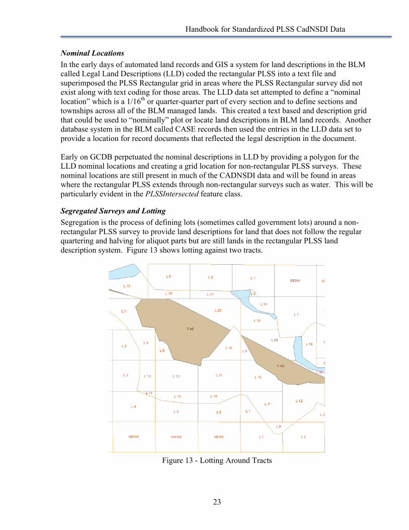
In Figure 11 N is a townsite survey, P is a parcel and T is a tract. These are all numbered and identified but they do not have a corresponding rectangular component. Water is another example that creates an apparent “hole” in the rectangular PLSS. Figure 12 shows the absence of Rectangular PLSS extending into a body of water. In this case the water body has been meandered, meaning that a line was run at the time of survey separating the
Handbook for Standardized PLSS CadNSDI Data
22
uplands from the water. The meander line is not necessarily the current shoreline and is not intended to change or update as the water body changes. It is a line run at the time of survey.
Figure 12 - Meandered Water Body
Notice in Figure 12 the island in the water body does have rectangular surveys. To summarize the general rules for PLSS rectangular versus PLSS non-rectangular surveys are:
General Rules for the Rectangular PLSS • The rectangular survey is a simultaneous conveyance • The polygons are created as a nested hierarchy with no internal junior or senior rights • Surveys are not segregated • Lost corners within rectangular surveys can be re-established by proportionate
methods because of equal rights among polygons General Rules for Non-Rectangular PLSS or Special Surveys • They protect an existing private right • They carve out a new right • They may be measured by metes and bounds and may have crossing closing corners • They have a junior/senior right relationships for rights among themselves and with
the rectangular PLSS • They may be segregated
Handbook for Standardized PLSS CadNSDI Data
23
Nominal Locations In the early days of automated land records and GIS a system for land descriptions in the BLM called Legal Land Descriptions (LLD) coded the rectangular PLSS into a text file and superimposed the PLSS Rectangular grid in areas where the PLSS Rectangular survey did not exist along with text coding for those areas. The LLD data set attempted to define a “nominal location” which is a 1/16th or quarter-quarter part of every section and to define sections and townships across all of the BLM managed lands. This created a text based and description grid that could be used to “nominally” plot or locate land descriptions in BLM land records. Another database system in the BLM called CASE records then used the entries in the LLD data set to provide a location for record documents that reflected the legal description in the document. Early on GCDB perpetuated the nominal descriptions in LLD by providing a polygon for the LLD nominal locations and creating a grid location for non-rectangular PLSS surveys. These nominal locations are still present in much of the CADNSDI data and will be found in areas where the rectangular PLSS extends through non-rectangular surveys such as water. This will be particularly evident in the PLSSIntersected feature class.
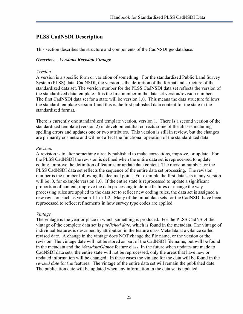
Segregated Surveys and Lotting Segregation is the process of defining lots (sometimes called government lots) around a non-rectangular PLSS survey to provide land descriptions for land that does not follow the regular quartering and halving for aliquot parts but are still lands in the rectangular PLSS land description system. Figure 13 shows lotting against two tracts.
Figure 13 - Lotting Around Tracts

Handbook for Standardized PLSS CadNSDI Data
24
The two tracts shown in Figure 13 (tracts 40 and 43) have government lots (the numbered polygons with the leading L). These lots segregate the tracts from the regular aliquot parts, seen along the bottom edge in Figure 13. The lots will have more or less than the expected 40 acres in a normal 1/16th and will have an irregular or non-rectangular boundary. The other common use of lotting is on the closing boundaries of townships, typically the north and west boundary but not always. Figure 14 shows the “regular” or non-segregation lotting in a PLSS Township.
Figure 14 - Non-Segregation Lotting in a PLSS Township
The lots, labeled with an “L” preceding the number are generally along the north and west boundary of the township, but notice that there is also lotting internal to sections 18 and 4. These areas will be notably greater or less than 40 acres. From the survey plat perspective where these lots have been identified the underlying “nominal” 1/16th part, such as the Northwest of the Northwest of Section 6, T 8N, R 1E, known also as NWNW, Section 6, T8N, R1E, does not exist. A land description for this 1/16th nominal may be included in the BLM’s LLD data set and it will also be in the PLSSIntersected if it was collected by GCDB, but it will not be in the standardized CadNSDI.
Handbook for Standardized PLSS CadNSDI Data
25
PLSS CadNSDI Description This section describes the structure and components of the CadNSDI geodatabase.
Overview – Versions Revision Vintage Version A version is a specific form or variation of something. For the standardized Public Land Survey System (PLSS) data, CadNSDI, the version is the definition of the format and structure of the standardized data set. The version number for the PLSS CadNSDI data set reflects the version of the standardized data template. It is the first number in the data set version/revision number. The first CadNSDI data set for a state will be version 1.0. This means the data structure follows the standard template version 1 and this is the first published data content for the state in the standardized format. There is currently one standardized template version, version 1. There is a second version of the standardized template (version 2) in development that corrects some of the aliases including spelling errors and updates one or two attributes. This version is still in review, but the changes are primarily cosmetic and will not affect the functional operation of the standardized data Revision A revision is to alter something already published to make corrections, improve, or update. For the PLSS CadNSDI the revision is defined when the entire data set is reprocessed to update coding, improve the definition of features or update data content. The revision number for the PLSS CadNSDI data set reflects the sequence of the entire data set processing. The revision number is the number following the decimal point. For example the first data sets in any version will be .0, for example version 1.0. If the entire state is reprocessed to update a significant proportion of content, improve the data processing to define features or change the way processing rules are applied to the data set to reflect new coding rules, the data set is assigned a new revision such as version 1.1 or 1.2. Many of the initial data sets for the CadNSDI have been reprocessed to reflect refinements in how survey type codes are applied. Vintage The vintage is the year or place in which something is produced. For the PLSS CadNSDI the vintage of the complete data set is published date, which is found in the metadata. The vintage of individual features is described by attribution in the feature class Metadata at a Glance called revised date. A change in the vintage does NOT change the file name, or the version or the revision. The vintage date will not be stored as part of the CadNSDI file name, but will be found in the metadata and the MetadataGlance feature class. In the future when updates are made to CadNSDI data sets, the entire state will not be reprocessed, only the areas that have new or updated information will be changed. In these cases the vintage for the data will be found in the revised date for the features. The vintage of the entire data set will remain the published date. The publication date will be updated when any information in the data set is updated.

Handbook for Standardized PLSS CadNSDI Data
26
Overview Data Structure The CadNSDI geodatabase is a publication data structure and is a physical implementation of the FGDC Cadastral Data Content Standard. As a physical implementation it has been de-normalized, which means that some of the data is repeated across feature classes and codes and their descriptions are included together in the feature classes. The de-normalization makes it easier for users less familiar with the database tables and GIS to use the data and it may in some cases increase the speed and decrease the complexity for end users. The structure of the CadNSDI is not optimized for production, i.e. operation and maintenance. For data producers the data should the structured to support editing and data quality assurance tools. These same tools should be able to automatically generate the formats for publication from the production data sets. As examples, in the production data set the attribute information about parcels may be managed in in a real estate tax data system and the GIS may have only the parcel number. The attributes and the geometry would be joined and standardized for publication. Similarly in the Cadastral Reference Feature Data Set, the attributes for labeling and identifying PLSS Townships (State, Principal Meridian, Township and Range) could be stored in a related table and not repeatedly entered and then joined and extracted for the publication data set. At the root level of the geodatabase there are three components.
Cadastral Reference Feature Data Set This feature data set contains the data for the framework or structural framing for the description and indexing of landownership or land management parcels. The cadastral reference data does not define specific parcels or rights and interests; it provides the control or reference for describing parcels and rights and interests. Typically the cadastral reference information changes much less frequently than the parcel data and in many organizations the cadastral reference is maintained by a different group than the parcel data. Parcel Feature Data Set This feature data set contains the information on the core parcel information, which is the core parcel data representing the delineation of parcel information and associated core attributes. This data set is not populated for information originating from federal agencies, but it is available and used for states that have acquired local parcel data. Eventually it is expected that there will be a federal parcel feature and a state owned lands feature class in the feature data set to represent the federal and state managed lands. These feature classes will have different attributes than the core parcels for privately owned lands.
There are some underlying principles and practices that permeate all of the feature classes.
Data Stewards and MetadataGlance Feature Class The data steward is the authoritative source for the PLSS data. The data steward is identified for every polygon and then is selected out through a series of combines and
Handbook for Standardized PLSS CadNSDI Data
27
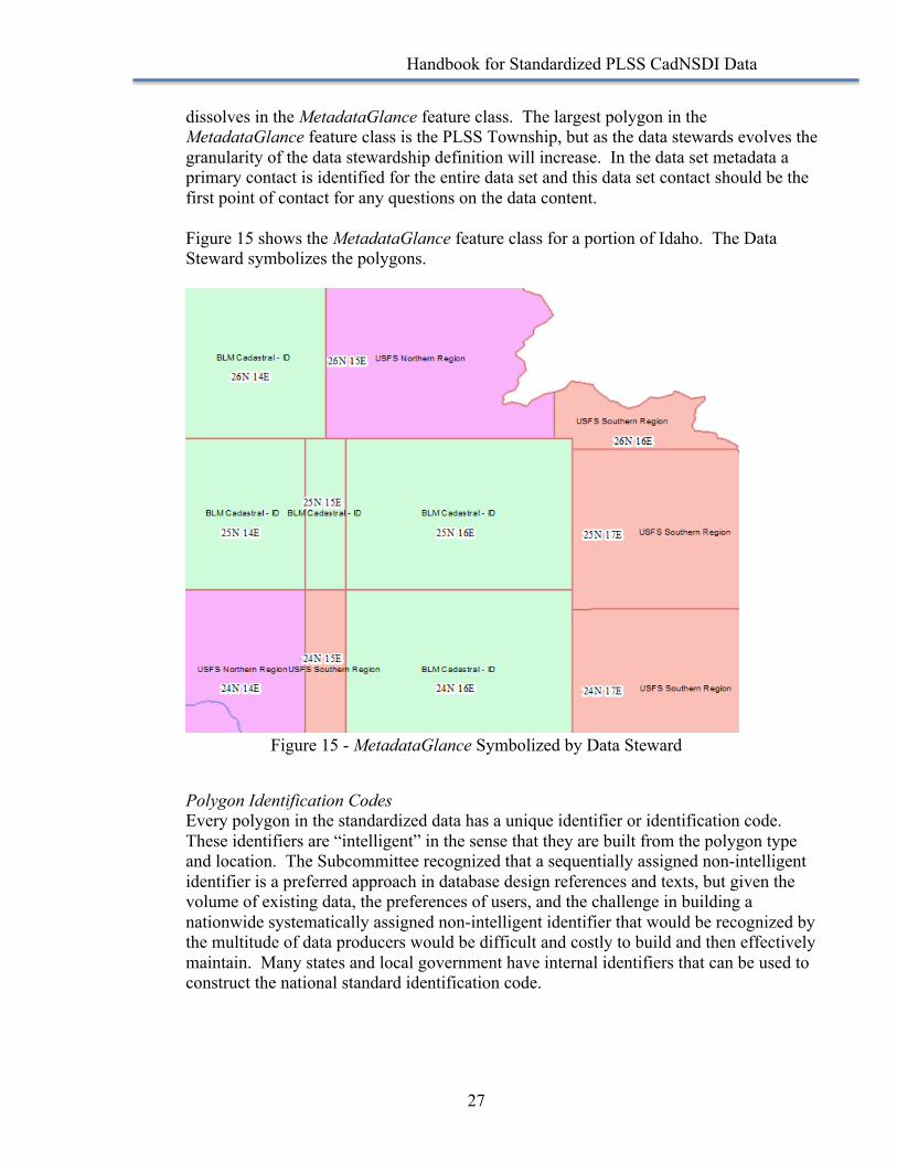
dissolves in the MetadataGlance feature class. The largest polygon in the MetadataGlance feature class is the PLSS Township, but as the data stewards evolves the granularity of the data stewardship definition will increase. In the data set metadata a primary contact is identified for the entire data set and this data set contact should be the first point of contact for any questions on the data content. Figure 15 shows the MetadataGlance feature class for a portion of Idaho. The Data Steward symbolizes the polygons.
Figure 15 - MetadataGlance Symbolized by Data Steward
Polygon Identification Codes Every polygon in the standardized data has a unique identifier or identification code. These identifiers are “intelligent” in the sense that they are built from the polygon type and location. The Subcommittee recognized that a sequentially assigned non-intelligent identifier is a preferred approach in database design references and texts, but given the volume of existing data, the preferences of users, and the challenge in building a nationwide systematically assigned non-intelligent identifier that would be recognized by the multitude of data producers would be difficult and costly to build and then effectively maintain. Many states and local government have internal identifiers that can be used to construct the national standard identification code.

Handbook for Standardized PLSS CadNSDI Data
28
Revised Date The revised date is used to indicate the last date a record was changed. It is not the capture or survey date, it is the date the digital record was last updated. Because the current practice is to update entire townships at one time, the date revised is captured in the MetadataGlance feature class for the entire township. It may also be possible to only update the special surveys or a portion of the township, but the tools and processes for this have not been developed for version 1 for the standardized data.

Handbook for Standardized PLSS CadNSDI Data
29
Feature Classes in Cadastral Reference PLSSIntersected This feature class is part of the Cadastral National Spatial Data Infrastructure (NSDI) CadNSDI publication data set for rectangular and non-rectangular Public Land Survey System (PLSS) data set. The metadata description in the Cadastral Reference System Feature Data Set more fully describes the entire data set. The fully intersected data is the atomic level of the PLSS that is similar to the Esri coverage or the smallest pieces used to build the PLSS. Polygons may overlap in this feature class. This feature class will also contain retired or replaced areas of the PLSS. The fully intersected polygons are used for conversion and for maintenance. This contains the atomic and fully attributed components of the other PLSS features. This is the feature class used to derive other feature classes in this feature data set. This feature class also contains retired or replaced features. MetadataGlance This feature class is part of the Cadastral National Spatial Data Infrastructure (NSDI) CadNSDI publication data set for rectangular and non-rectangular Public Land Survey System (PLSS) data set. The metadata description in the Cadastral Reference System Feature Data Set more fully describes the entire data set. This is a graphic representation of the data stewards for the Public Land Survey System (PLSS). For BLM data sets the data steward is identified at the township level or smaller area. The Data Steward is the agency that will be responsible for updates of the PLSS. In the shared environment of the National Spatial Data Infrastructure (NSDI) the data steward for an area is the primary coordinator or agency responsible for making updates or causing updates to be made. Any questions about data content should be directed to the data steward. The purpose of this feature class is to provide a visual reference for the metadata about stewards and revision dates. PLSSTownship This feature class is part of the Cadastral National Spatial Data Infrastructure (NSDI) CadNSDI publication data set for rectangular and non-rectangular Public Land Survey System (PLSS) data set. The metadata description in the Cadastral Reference System Feature Data Set more fully describes the entire data set. This feature class contains the Public Land Survey System Townships that are the primary unit of survey for the PLSS, nominally six miles on a side, usually containing 36 sections. PLSS Townships are numbered from base lines and principal meridians. This feature class provides the polygons for the PLSS Townships. These polygons are built from the PLSS Fully Intersected feature class by dissolving on the PLSSID in the PLSSIntersected feature class. PLSSFirstDivision This feature class is part of the Cadastral National Spatial Data Infrastructure (NSDI) CadNSDI publication data set for rectangular and non-rectangular Public Land Survey System (PLSS) data set. The metadata description in the Cadastral Reference System Feature Data Set more fully describes the entire data set. The PLSS First Division is commonly the section but can also be lots or tracts or protracted blocks. This feature class is the first set of divisions for a PLSS Township. If the first division is a section the nominal size is one mile on a side and 640 acres,
Handbook for Standardized PLSS CadNSDI Data
30
but actual sections will vary. Symbolizing this feature class on the first division type will help GIS users see where sections exist and where other types of divisions are used to divide the PLSS Townships. PLSSSecondDivision This feature class is part of the Cadastral National Spatial Data Infrastructure (NSDI) CadNSDI publication data set for rectangular and non-rectangular Public Land Survey System (PLSS) data set. The metadata description in the Cadastral Reference System Feature Data Set more fully describes the entire data set. This feature class is the second division of the PLSS and is the quarter, quarter-quarter, sixteenth or government lot divisions of the PLSS. The second and third divisions are combined into this feature class as an intentional de-normalization of the PLSS hierarchical data. The polygons in this feature class represent the smallest division that has been defined for the purposes of PLSS Cadastral Framework needs. For example in some cases sections have only been divided to the quarter. Typically divisions below the sixteenth are in the PLSSSpecialSurvey or NSDIParcel feature class, but in some cases in the BLM managed data sets smaller aliquot divisions are included in the second division. This feature class provides the graphic of the aliquot or government lot divisions of the PLSS Township. This feature class is only the second division polygons and is not the combination of all divisions, so this feature class does not include Townships and First Divisions. The PLSS Second division also includes the indication of surveyed or protracted status for the division. This is useful for symbolizing the areas where no surveys exist and the PLSS divisions have been derived from protraction (unsurveyed, protracted) or even calculated from division rules. (unsurveyed unprotracted) PLSSpecialSurvey This feature class is part of the Cadastral National Spatial Data Infrastructure (NSDI) CadNSDI publication data set for rectangular and non-rectangular Public Land Survey System (PLSS) data set. The metadata description in the Cadastral Reference System Feature Data Set more fully describes the entire data set. This feature class contains the Special Surveys that are non-rectangular components of the PLSS from BLM survey records. These special survey areas are generated from combinations of special survey codes, designators, notes and suffix information in the PLSSIntersected feature class. These are the graphic representation of non-rectangular PLSS components determined from surveys reflecting official BLM records. In many cases the non-rectangular components in this feature class are essential to completing the PLSS representation for many GIS applications. ConflictedAreas This feature class is part of the Cadastral National Spatial Data Infrastructure (NSDI) CadNSDI publication data set for rectangular and non-rectangular Public Land Survey System (PLSS) data set. The metadata description in the Cadastral Reference System Feature Data Set more fully describes the entire data set. The conflicted areas feature class is a depiction of known overlaps or gaps resulting from two or more different surveys of the same area. The ConflictedArea feature class is to inform PLSS CadNSDI users on existing conflicted areas and provides the data stewards. For more information on the origins, impacts and possible resolution of conflicted areas contact the data stewards identified in the conflicted area.
Handbook for Standardized PLSS CadNSDI Data
31
MeanderedWater The meandered water feature class contains polygons representing the water area meandered on the original government plats. The Meandered water is NOT the same as the current or historical hydrography or bank-to-bank water features. Meander lines represent the limits of the meandered water boundaries as shown on the plats. The meander water lines are “broken” at the PLSS Township lines. PLSSPoint This feature class is part of the Cadastral National Spatial Data Infrastructure (NSDI) CADNSDI publication data set for rectangular and non-rectangular Public Land Survey System (PLSS) data set. The metadata description in the Cadastral Reference System Feature Data Set more fully describes the entire data set. These are the corners of the PLSS. This feature class contains summary information about the coordinate location and reliability of corner coordinate information. Alternate names or aliases for corners are also included in this feature class. The PLSSPoint feature class provides the essential observed coordinate information for PLSS corners. This is not the complete data set for corners. These are the most current coordinates and a summary of information about the accuracy and quality of the coordinate values. Contact the identified Data Steward for more information.
Handbook for Standardized PLSS CadNSDI Data
32
Appendix A - Acronyms and Abbreviations Acronym Description Brief Discussion BLM Bureau of Land Management A Division of the Department of Interior that
includes Cadastral Survey PLSS Public Land Survey System The system of measuring and inventorying
land in thirty states NSDI National Spatial Data Infrastructure The goal of NSDI is to reduce duplication of
effort among agencies, improve quality and reduce costs related to geographic information, to make geographic data more accessible to the public, to increase the benefits of using available data, and to establish key partnerships with states, counties, cities, tribal nations, academia and the private sector to increase data availability.
CadNSDI Cadastral National Spatial Data Infrastructure
FGDC Federal Geographic Data Committee An organization within The US Geologic Survey, which is part of the Department of Interior, charged with coordinating the development of the NSDI
GCDB Geographic Coordinate Database A program within Cadastral Survey to develop and maintain coordinate values on corners of the PLSS to support mapping and GIS applications
LLD Legal Land Description A database in the BLM that provides land descriptions for transactions.
PCCS Public Land Survey System Coordinate Computational System
A software program developed by Bill Ball in the 1970’s to perform computations on the PLSS.
GMM GCDB Measurement Management A program developed by cadastral survey in the 1990’s to replace PCCS and introduce full least squares analysis of PLSS measurements.
DOI Department of Interior
Handbook for Standardized PLSS CadNSDI Data
33
Appendix B - Standard Domains for PLSS CadNSDI This appendix is posted to the Cadastral Subcommittee out reach web site (http://www.nationalcad.org) under standard implementation information (http://nationalcad.org/CadStandContent/CadStandContent.html) Users should check this site for updates to the content listed here. Introduction The Public Land Survey System (PLSS) Cadastral National Spatial Data Infrastructure (CadNSDI) publication data set standards were finalized as Version 2 in October of 2012. A zipped file containing the database documentation and schema is posted in the Cadastral Subcommittee’s outreach page (http://www.nationalcad.org) In Version 2 of the standard the domains of values were listed as recommended or suggested. Since October of 2012 the PLSS data for 20 of the 30 Public Domain states have been reviewed and standardized. Through that process the domains of values have been more clearly articulated and defined. The Subcommittee felt that a complete review of PLSS data was necessary before the domain of values could be finalized and this milestone has been reached. This document provides the standardized domain of values for the elements with a standardized domain in PLSS CadNSDI data sets. Most of the domains include a code and description. As database and GIS technology advances there is less reliance on coded values and increased ability to use the text or description of an attribute. The codes and descriptions have been finalized and standardized, but the Subcommittee acknowledges that some implementations may choose to use only the description and not the associated code. In some cases the code is used as part of a concatenated unique identification key and users that chose to not capture the standard code along with the standard description will need to use the standard code to generate concatenated keys. Please note that because of the high degree of variability in the PLSS, not all codes and domains apply to all states. Additional domain values should be submitted to the Cadastral Subcommittee for evaluation for inclusion in the standard domains. (http://nationalcad.org/CadStandContent/CadStandContent.html) There may be some non-standard codes and code descriptions in existing PLSS CadNSDI data sets. These non-standard values will be addressed through regular maintenance.
Handbook for Standardized PLSS CadNSDI Data
34
Duplicate Coding In cases where a PLSS rectangular feature is duplicated, for example two section 31s in a Township or two townships with the same state-principal meridian-township-range number and direction, the duplicate code is assigned with an A to the feature closest to the initial point and succeeding B, C, etc. to those further away from the initial point. There should never be an A duplicate code without a B duplicate code. Zero (0) in any duplicate field means there are no duplicates. Any letter indicates there are duplicates. First Division Type The first division is the first division of a PLSS Township and is most commonly a section. However, there are many types of first divisions and these are identified in the first division type. If an implementation uses a default value, it should be the Section. Also of note is that Tracts and Donation Land Claims (DLCs) are not a first division types. The tracts and DLCs are a PLSS Special Survey and are a metes and bounds survey protecting bona fide rights and are not part of the PLSS rectangular descriptions. Previous implementations may have included tracts and DLCs as a first division type but this has been corrected. In some eastern states there has been a first division for a tract that generally refers to islands. The first division type codes are two characters to assist in discerning between the first and second division type. . First Division Type Code
First Division Type Description
Notes
UA Unsectionalized Area Unsectionalized areas are lands that were never divided and no protraction or definition of division was generated. Over time these areas are expected to have division types added
SN Section The section is the most commonly occurring first division and is nominally one mile on a side. The section numbers are commonly 1 to 36 but section numbers as high as 48 have been identified.
LT Lot These are lots that occur only rarely in non-sectionalized Townships. In these cases the township is divided into lots, but again this is a rare occurrence.
PB Protracted Block Protracted Blocks are divisions that provide a defined division in unsurveyed PLSS Townships. Protracted Blocks are defined by the coordinate values of the corners.
FS Fractional Section Fractional sections are sections that are invaded by water or a protraction such that at least one quarter corner can not be established and the method for subdividing the section is modified. The fractional sections may not have been identified in some of the early standard implementations.
QT Quarter Township The quarter townships exist in Ohio only. These are divisions that quarter the township and in some cases the quarter township is quartered again into four lots or parcels.
TR Tract There are two uses of Tracts as a first division. (1) PLSS Tracts in the eastern states that should be in the PLSS Special Survey Feature Class but are included in the First Division as a transition to the fully compliant standard. (2) Paragraph 3-122 of the 1973 manual and 3-199 in the 2009 manual "when administration or disposal requires no

Handbook for Standardized PLSS CadNSDI Data
35
subdivision, an island is given a tract number within a township. In such cases, the section lines need not be extended to the island."
UP * Unsurveyed Protracted Unsurveyed Protracted divisions are always a section but have not been measured by survey. The protraction diagram is a plan of survey.
UN * Unsurveyed Unprotracted Unsurveyed Unprotracted divisions are always sections but there is no survey or plan of survey. These divisions have been termed extended PLSS or PLSS grids in some implementations.
UK Unknown If the type of first division is not known than this code and description is available as a placeholder until the type of first division can be established.
* The Unsurveyed Protracted and Unsurveyed Unprotracted values reference the survey status or survey condition of a Section. The first division type for features coded as UP or UN is Section (SN). The survey type code and description in the PLSS CadNSDI feature classes should be used to indicate the survey status of the feature. These domains are included as transitional values and will be eliminated over time.
Handbook for Standardized PLSS CadNSDI Data
36
Second Division Type The second division is the second division of the PLSS Township. The most commonly occurring second division types are aliquot parts and government lots. The Remainder Lot is a relatively new value and very few data sets will have this value initially. Second Division Type Code
Second Division Type Description
Notes
A Aliquot Part An aliquot part is a division made by halving and quartering a section. These are identified by the cardinal position such as Northeast (NE).
B Remainder Aliquot Part Remainder Aliquot Parts are residuals or portions or significantly smaller than nominal aliquot parts. These may be left over after a special survey or other survey cuts into an existing aliquot part and a portion of the aliquot has not been designated as a government lot and is remaining as an aliquot part.
L Lot A subdivision of a section that is not designated as an aliquot part of a section and is identified by a number. A Government Lot, or Lot, may be regular or irregular in shape.
Q Quarter Section A quarter section is an aliquot part that divides the section into quarter parts only. In most cases quarter sections will be coded as A and the distinction between aliquot part and a quarter aliquot part is a state-by-state preference. The preferred coding is to use A for all aliquot parts.
O Unnumbered Lot An unnumbered government lot is an area of land that appears to be a government lot because of its location in the section and its acreage. Because Government Lots must be surveyed and have a number, it is expected that existing unnumbered government lots will gradually transition to either remainder aliquot parts or remainder government lots with a number.
V Remainder Lot A Remainder Government Lot or Remainder Lot are residuals or portions of Lots. These may be left over after a special survey or other survey cuts into an existing Lot.
U * Unsurveyed Protracted Unsurveyed Protracted divisions are always aliquot parts but have not been measured by survey. The protraction diagram is a plan of survey.
Z * Unsurveyed Unprotracted Unsurveyed Unprotracted divisions are always aliquot parts but there is no survey or plan of survey. These divisions have been termed extended PLSS or PLSS grids in some implementations.
* The Unsurveyed Protracted and Unsurveyed Unprotracted values reference the survey status or survey condition of a Section. The second division type for features coded as U or Z is Aliquot Part (A). The Survey type code and description in the PLSS CadNSDI feature classes should be used to indicate the survey status of the feature. These domains are included as transitional values and will be eliminated over time
Handbook for Standardized PLSS CadNSDI Data
37
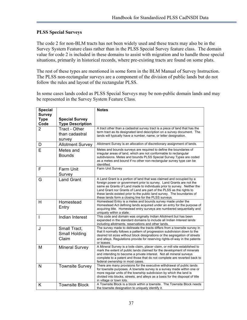
PLSS Special Surveys The code 2 for non-BLM tracts has not been widely used and these tracts may also be in the Survey System Feature class rather than in the PLSS Special Survey feature class. The domain value for code 2 is included in these domains to assist with migration and to handle those special situations, primarily in historical records, where pre-existing tracts are found on some plats. The rest of these types are mentioned in some form in the BLM Manual of Survey Instruction. The PLSS non-rectangular surveys are a component of the division of public lands but do not follow the rules and layout of the rectangular PLSS. In some cases lands coded as PLSS Special Surveys may be non-public domain lands and may be represented in the Survey System Feature Class. Special Survey Type Code
Special Survey Type Description
Notes
2 Tract - Other than cadastral survey
A tract other than a cadastral survey tract is a piece of land that has the term tract as its designated land description on a survey document. The lands will typically have a number, name, or letter designation.
D Allotment Survey Allotment Survey is an allocation of discretionary assignment of lands.
E Metes and Bounds
Metes and bounds surveys are required to define the boundaries of irregular areas of land, which are not conformable to rectangular subdivisions. Metes and bounds PLSS Special Survey Types are coded as a metes and bound if no other non-rectangular survey type can be identified.
F Farm Unit Survey
Farm Unit Survey
G Land Grant A Land Grant is a portion of land that was claimed and occupied by a foreign power or government prior to survey. Land Grants are not the same as Grants of Land made to individuals prior to survey. Neither the Land Grant nor Grants of Land are part of the PLSS as the rights to these lands existed prior to the public land survey. The boundaries of these lands form a closing line for the PLSS surveys.
H Homestead Entry
Homestead Entry is a metes and bounds survey made under the Homestead Act defining lands acquired under an entry for the purpose of acquiring title. Homestead entry surveys are numbered sequentially and uniquely within a state.
I Indian Interest This code and domain was originally Indian Allotment but has been expanded in the standard domains to include all Indian Interest lands including allotments. reservations and other lands.
J Small Tract, Small Holding Claim
The survey made to delineate the tracts differs from a townsite survey in that it normally follows a pattern of progression subdivision down to the desired lot sizes without block designations or the segregation of streets and alleys. Regulations provide for reserving rights-of-way in the patents or leases.
M Mineral Survey A Mineral Survey is a lode claim, placer claim, or mill site established to mark the extent of public lands claimed for the development of minerals and intending to become a private interest. Not all mineral surveys complete to a patent and those that do not complete are reverted back to federal ownership in most cases.
N Townsite Survey There are many provisions for the executive withdrawal of public lands for townsite purposes. A townsite survey is a survey made within one or more regular units of the township subdivision by which the land is divided into blocks, streets, and alleys as a basis for the disposal of title in village or town lots.
K Townsite Block A Townsite Block is a block within a townsite. The Townsite Block needs the townsite designation to uniquely identify it.
Handbook for Standardized PLSS CadNSDI Data
38
Y Townsite Outlot A Townsite Outlot is a lot designated for public or community use within a townsite.
P BLM Parcel BLM Parcel
Q Donation Land Claim
Donation Land Claims are portions of land that are 160 or 320 acres in size granted under the Donation Land Act of 1850 to citizens who resided in the Oregon Territory. These are not the same as donation lands that were public lands donated or granted as an incentive for construction, such as railroad donations.
S United States Survey - Alaska Only
United States Surveys exist only in Alaska. These are similar in form to Townsite Surveys and provide for the disposal of public lands for occupation and settlement.
T Tract A tract is portion of land that protects a bona fide right. Tracts are metes and bounds surveys that define the perimeter of lands settled between the time of the plan of survey and the actual field survey. Settlement occurred following the boundaries intended to be as defined in the rectangular survey but do not conform to the actual rectangular survey. Tracts are always contained within a PLSS Township and PLSS Township lines encompass the tracts. Tracts are numbered within the Township taking the next highest number available after the highest section number.
X Exchange An exchange survey is a portion of land that has been described to support the exchange of private lands and public lands. These are metes and bounds surveys.

Handbook for Standardized PLSS CadNSDI Data
39
Principal Meridians Principal Meridian Code Principal Meridian Description 01 1st Meridian 02 2nd Meridian 03 3rd Meridian 04 4th Meridian 05 5th Meridian 06 6th Meridian 07 Black Hills Meridian 08 Boise Meridian 09 Chickasaw Meridian 10 Choctaw Meridian 11 Cimarron Meridian 12 Copper River Meridian 13 Fairbanks Meridian 14 Gila-Salt River Meridian 15 Humboldt Meridian 16 Huntsville Meridian 17 Indian Meridian 18 Louisiana Meridian 19 Michigan Meridian 20 Montana Meridian 21 Mount Diablo Meridian 22 Navajo Meridian 23 New Mexico Meridian 24 St. Helena Meridian 25 St. Stephens Meridian 26 Salt Lake Meridian 27 San Bernardino Meridian 28 Seward Meridian 29 Tallahassee Meridian 30 Uintah Meridian 31 Ute Meridian 32 Washington Meridian 33 Willamette Meridian 34 Wind River Meridian 36 Between the Miamis 37 Muskingum River 38 Ohio River Base 44 Kateel River Meridian 45 Umiat Meridian 46 Extended Fourth Meridian 47 West of the Great Miami 48 Base Line of the US Military Survey 99 Not Applicable

Handbook for Standardized PLSS CadNSDI Data
40
State Names and Codes Abbreviation State Name State FIPS Code AL ALABAMA 01 AK ALASKA 02 AZ ARIZONA 04 AR ARKANSAS 05 CA CALIFORNIA 06 CO COLORADO 08 CT CONNECTICUT 09 DE DELAWARE 10 DC DISTRICT OF COLUMBIA 11 FL FLORIDA 12 GA GEORGIA 13 HI HAWAII 15 ID IDAHO 16 IL ILLINOIS 17 IN INDIANA 18 IA IOWA 19 KS KANSAS 20 KY KENTUCKY 21 LA LOUISIANA 22 ME MAINE 23 MD MARYLAND 24 MA MASSACHUSETTS 25 MI MICHIGAN 26 MN MINNESOTA 27 MS MISSISSIPPI 28 MO MISSOURI 29 MT MONTANA 30 NE NEBRASKA 31 NV NEVADA 32 NH NEW HAMPSHIRE 33 NJ NEW JERSEY 34 NM NEW MEXICO 35 NY NEW YORK 36 NC NORTH CAROLINA 37 ND NORTH DAKOTA 38 OH OHIO 39 OK OKLAHOMA 40 OR OREGON 41 PA PENNSYLVANIA 42 RI RHODE ISLAND 44 SC SOUTH CAROLINA 45 SD SOUTH DAKOTA 46 TN TENNESSEE 47 TX TEXAS 48 UT UTAH 49 VT VERMONT 50 VA VIRGINIA 51 WA WASHINGTON 53
Handbook for Standardized PLSS CadNSDI Data
41
WV WEST VIRGINIA 54 WI WISCONSIN 55 WY WYOMING 56 US National AS AMERICAN SAMOA 60 GU GUAM 66 PR PUERTO RICO 72 VI US VIRGIN ISLANDS 78 MP N. MARIANA ISLANDS 69
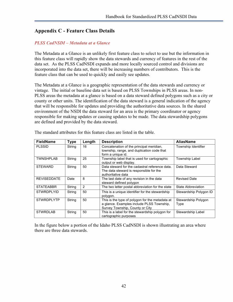
Handbook for Standardized PLSS CadNSDI Data
42
Appendix C - Feature Class Details PLSS CadNSDI – Metadata at a Glance The Metadata at a Glance is an unlikely first feature class to select to use but the information in this feature class will rapidly show the data stewards and currency of features in the rest of the data set. As the PLSS CadNSDI expands and more locally sourced control and divisions are incorporated into the data set, there will be increasing numbers of contributors. This is the feature class that can be used to quickly and easily see updates. The Metadata at a Glance is a geographic representation of the data stewards and currency or vintage. The initial or baseline data set is based on PLSS Townships in PLSS areas. In non-PLSS areas the metadata at a glance is based on a data steward defined polygons such as a city or county or other units. The identification of the data steward is a general indication of the agency that will be responsible for updates and providing the authoritative data sources. In the shared environment of the NSDI the data steward for an area is the primary coordinator or agency responsible for making updates or causing updates to be made. The data stewardship polygons are defined and provided by the data steward. The standard attributes for this feature class are listed in the table. FieldName Type Length Description AliasName PLSSID String 16 Concatenation of the principal meridian,
township, range, and duplication code that form a unique id.
Township Identifier
TWNSHPLAB String 25 Township label that is used for cartographic output or web display.
Township Label
STEWARD String 50 Data steward for the cadastral reference data. The data steward is responsible for the authoritative data
Data Steward
REVISEDDATE Date 8 The last date of any revision in the data steward defined polygon
Revised Date
STATEABBR String 2 The two letter postal abbreviation for the state State Abbreviation STWRDPLYID String 50 This is a unique identifier for the stewardship
polygon. Stewardship Polygon ID
STWRDPLYTP String 50 This is the type of polygon for the metadata at a glance. Examples include PLSS Township, Survey Township, County or City
Stewardship Polygon Type
STWRDLAB String 50 This is a label for the stewardship polygon for cartographic purposes
Stewardship Label
In the figure below a portion of the Idaho PLSS CadNSDI is shown illustrating an area where there are three data stewards.
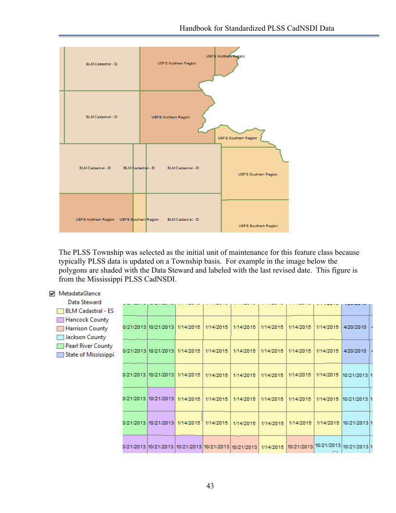
Handbook for Standardized PLSS CadNSDI Data
43
The PLSS Township was selected as the initial unit of maintenance for this feature class because typically PLSS data is updated on a Township basis. For example in the image below the polygons are shaded with the Data Steward and labeled with the last revised date. This figure is from the Mississippi PLSS CadNSDI.
Handbook for Standardized PLSS CadNSDI Data
44
The initial data set reflects the nationwide collection and standardization efforts. As this data set continues to be updated the analysis and information in the Metadata at a Glance will grow, the unit of maintenance will become better defined and more granular. Potential expanded attributes data stewards may consider will be links to published geospatial metadata, statements of overall accuracy, and aggregated or compiled date. Individual users may want to add fields to track download or access dates. All of these expansions are compliant with the standard intent. This feature class can also be used to link to data contributors web sites or data contributor metadata. The analysis that can be done and the functions feature class can support for data set management are numerous, especially in shared maintenance and web service environments.
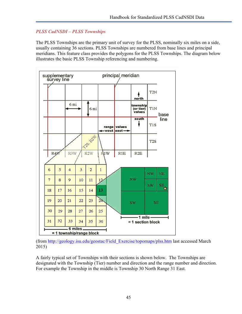
Handbook for Standardized PLSS CadNSDI Data
45
PLSS CadNSDI – PLSS Townships The PLSS Townships are the primary unit of survey for the PLSS, nominally six miles on a side, usually containing 36 sections. PLSS Townships are numbered from base lines and principal meridians. This feature class provides the polygons for the PLSS Townships. The diagram below illustrates the basic PLSS Township referencing and numbering.
(from http://geology.isu.edu/geostac/Field_Exercise/topomaps/plss.htm last accessed March 2015) A fairly typical set of Townships with their sections is shown below. The Townships are designated with the Township (Tier) number and direction and the range number and direction. For example the Township in the middle is Township 30 North Range 31 East.
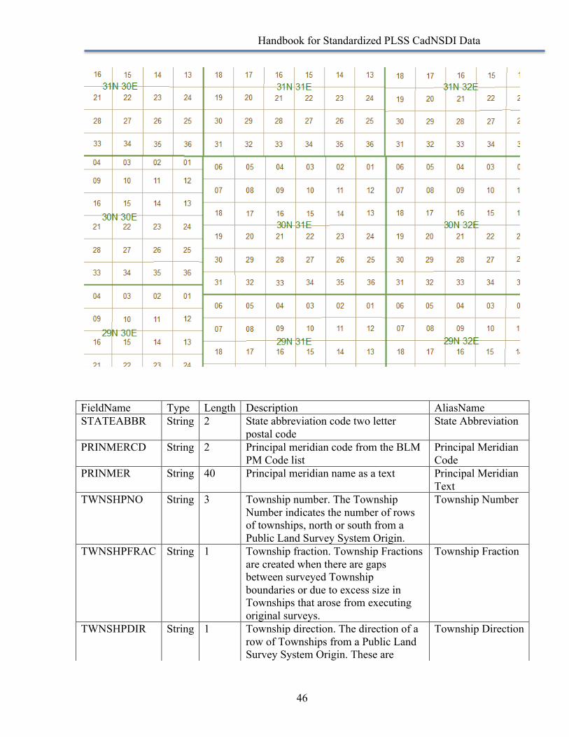
Handbook for Standardized PLSS CadNSDI Data
46
FieldName Type Length Description AliasName STATEABBR String 2 State abbreviation code two letter
postal code State Abbreviation
PRINMERCD String 2 Principal meridian code from the BLM PM Code list
Principal Meridian Code
PRINMER String 40 Principal meridian name as a text Principal Meridian Text
TWNSHPNO String 3 Township number. The Township Number indicates the number of rows of townships, north or south from a Public Land Survey System Origin.
Township Number
TWNSHPFRAC String 1 Township fraction. Township Fractions are created when there are gaps between surveyed Township boundaries or due to excess size in Townships that arose from executing original surveys.
Township Fraction
TWNSHPDIR String 1 Township direction. The direction of a row of Townships from a Public Land Survey System Origin. These are
Township Direction
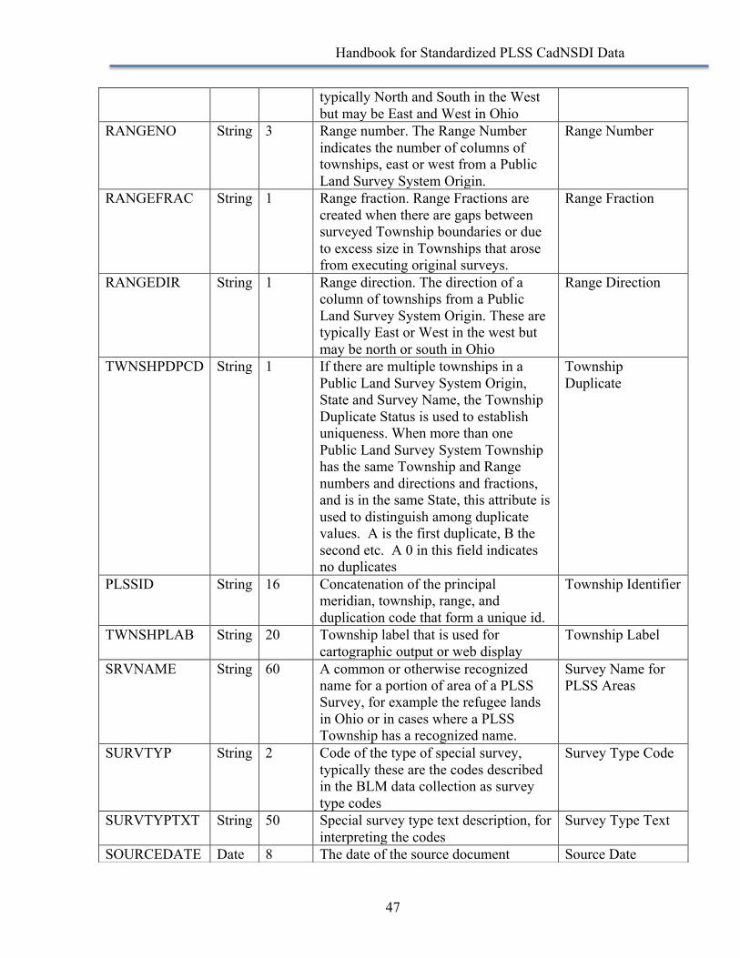
Handbook for Standardized PLSS CadNSDI Data
47
typically North and South in the West but may be East and West in Ohio
RANGENO String 3 Range number. The Range Number indicates the number of columns of townships, east or west from a Public Land Survey System Origin.
Range Number
RANGEFRAC String 1 Range fraction. Range Fractions are created when there are gaps between surveyed Township boundaries or due to excess size in Townships that arose from executing original surveys.
Range Fraction
RANGEDIR String 1 Range direction. The direction of a column of townships from a Public Land Survey System Origin. These are typically East or West in the west but may be north or south in Ohio
Range Direction
TWNSHPDPCD String 1 If there are multiple townships in a Public Land Survey System Origin, State and Survey Name, the Township Duplicate Status is used to establish uniqueness. When more than one Public Land Survey System Township has the same Township and Range numbers and directions and fractions, and is in the same State, this attribute is used to distinguish among duplicate values. A is the first duplicate, B the second etc. A 0 in this field indicates no duplicates
Township Duplicate
PLSSID String 16 Concatenation of the principal meridian, township, range, and duplication code that form a unique id.
Township Identifier
TWNSHPLAB String 20 Township label that is used for cartographic output or web display
Township Label
SRVNAME String 60 A common or otherwise recognized name for a portion of area of a PLSS Survey, for example the refugee lands in Ohio or in cases where a PLSS Township has a recognized name.
Survey Name for PLSS Areas
SURVTYP String 2 Code of the type of special survey, typically these are the codes described in the BLM data collection as survey type codes
Survey Type Code
SURVTYPTXT String 50 Special survey type text description, for interpreting the codes
Survey Type Text
SOURCEDATE Date 8 The date of the source document Source Date
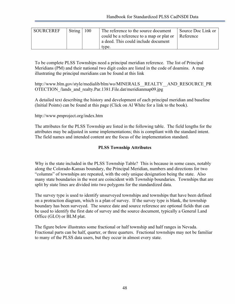
Handbook for Standardized PLSS CadNSDI Data
48
To be complete PLSS Townships need a principal meridian reference. The list of Principal Meridians (PM) and their national two digit codes are listed in the code of doamins. A map illustrating the principal meridians can be found at this link http://www.blm.gov/style/medialib/blm/wo/MINERALS__REALTY__AND_RESOURCE_PROTECTION_/lands_and_realty.Par.1381.File.dat/meridianmap09.jpg A detailed text describing the history and development of each principal meridian and baseline (Initial Points) can be found at this page (Click on Al White for a link to the book). http://www.pmproject.org/index.htm The attributes for the PLSS Township are listed in the following table. The field lengths for the attributes may be adjusted in some implementations; this is compliant with the standard intent. The field names and intended content are the focus of the implementation standard.
PLSS Township Attributes
Why is the state included in the PLSS Township Table? This is because in some cases, notably along the Colorado-Kansas boundary, the Principal Meridian, numbers and directions for two “columns” of townships are repeated, with the only unique designation being the state. Also many state boundaries in the west are coincident with Township boundaries. Townships that are split by state lines are divided into two polygons for the standardized data. The survey type is used to identify unsurveyed townships and townships that have been defined on a protraction diagram, which is a plan of survey. If the survey type is blank, the township boundary has been surveyed. The source date and source reference are optional fields that can be used to identify the first date of survey and the source document, typically a General Land Office (GLO) or BLM plat. The figure below illustrates some fractional or half township and half ranges in Nevada. Fractional parts can be half, quarter, or three quarters. Fractional townships may not be familiar to many of the PLSS data users, but they occur in almost every state.
SOURCEREF String 100 The reference to the source document could be a reference to a map or plat or a deed. This could include document type.
Source Doc Link or Reference
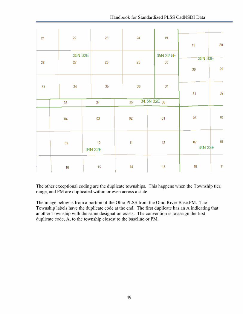
Handbook for Standardized PLSS CadNSDI Data
49
The other exceptional coding are the duplicate townships. This happens when the Township tier, range, and PM are duplicated within or even across a state. The image below is from a portion of the Ohio PLSS from the Ohio River Base PM. The Township labels have the duplicate code at the end. The first duplicate has an A indicating that another Township with the same designation exists. The convention is to assign the first duplicate code, A, to the township closest to the baseline or PM.
Handbook for Standardized PLSS CadNSDI Data
50
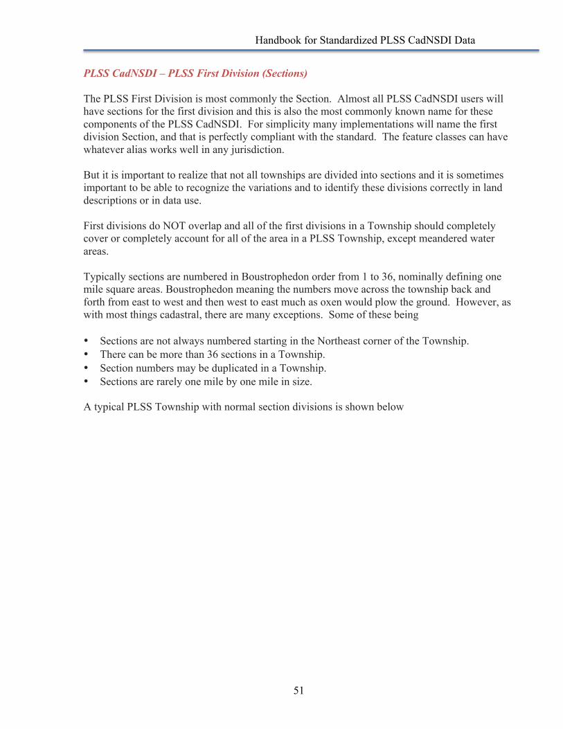
Handbook for Standardized PLSS CadNSDI Data
51
PLSS CadNSDI – PLSS First Division (Sections) The PLSS First Division is most commonly the Section. Almost all PLSS CadNSDI users will have sections for the first division and this is also the most commonly known name for these components of the PLSS CadNSDI. For simplicity many implementations will name the first division Section, and that is perfectly compliant with the standard. The feature classes can have whatever alias works well in any jurisdiction. But it is important to realize that not all townships are divided into sections and it is sometimes important to be able to recognize the variations and to identify these divisions correctly in land descriptions or in data use. First divisions do NOT overlap and all of the first divisions in a Township should completely cover or completely account for all of the area in a PLSS Township, except meandered water areas. Typically sections are numbered in Boustrophedon order from 1 to 36, nominally defining one mile square areas. Boustrophedon meaning the numbers move across the township back and forth from east to west and then west to east much as oxen would plow the ground. However, as with most things cadastral, there are many exceptions. Some of these being • Sections are not always numbered starting in the Northeast corner of the Township. • There can be more than 36 sections in a Township. • Section numbers may be duplicated in a Township. • Sections are rarely one mile by one mile in size. A typical PLSS Township with normal section divisions is shown below
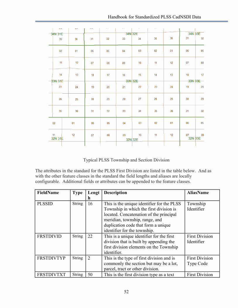
Handbook for Standardized PLSS CadNSDI Data
52
Typical PLSS Township and Section Division
The attributes in the standard for the PLSS First Division are listed in the table below. And as with the other feature classes in the standard the field lengths and aliases are locally configurable. Additional fields or attributes can be appended to the feature classes. FieldName Type Lengt
h Description AliasName
PLSSID String 16 This is the unique identifier for the PLSS Township in which the first division is located. Concatenation of the principal meridian, township, range, and duplication code that form a unique identifier for the township.
Township Identifier
FRSTDIVID String 22 This is a unique identifier for the first division that is built by appending the first division elements on the Township identifier.
First Division Identifier
FRSTDIVTYP String 2 This is the type of first division and is commonly the section but may be a lot, parcel, tract or other division.
First Division Type Code
FRSTDIVTXT String 50 This is the first division type as a text First Division
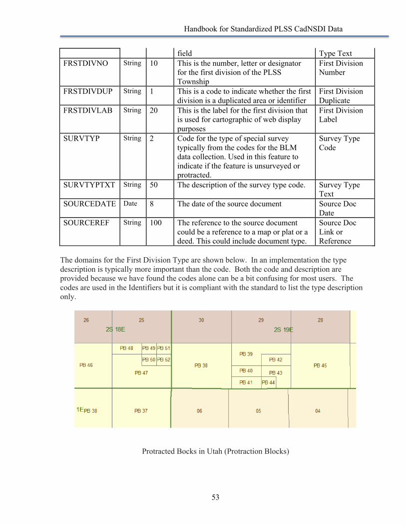
Handbook for Standardized PLSS CadNSDI Data
53
field Type Text FRSTDIVNO String 10 This is the number, letter or designator
for the first division of the PLSS Township
First Division Number
FRSTDIVDUP String 1 This is a code to indicate whether the first division is a duplicated area or identifier
First Division Duplicate
FRSTDIVLAB String 20 This is the label for the first division that is used for cartographic of web display purposes
First Division Label
SURVTYP String 2 Code for the type of special survey typically from the codes for the BLM data collection. Used in this feature to indicate if the feature is unsurveyed or protracted.
Survey Type Code
SURVTYPTXT String 50 The description of the survey type code. Survey Type Text
SOURCEDATE Date 8 The date of the source document Source Doc Date
SOURCEREF String 100 The reference to the source document could be a reference to a map or plat or a deed. This could include document type.
Source Doc Link or Reference
The domains for the First Division Type are shown below. In an implementation the type description is typically more important than the code. Both the code and description are provided because we have found the codes alone can be a bit confusing for most users. The codes are used in the Identifiers but it is compliant with the standard to list the type description only.
Protracted Bocks in Utah (Protraction Blocks)
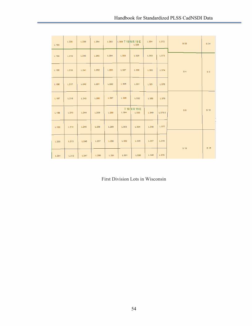
Handbook for Standardized PLSS CadNSDI Data
54
First Division Lots in Wisconsin
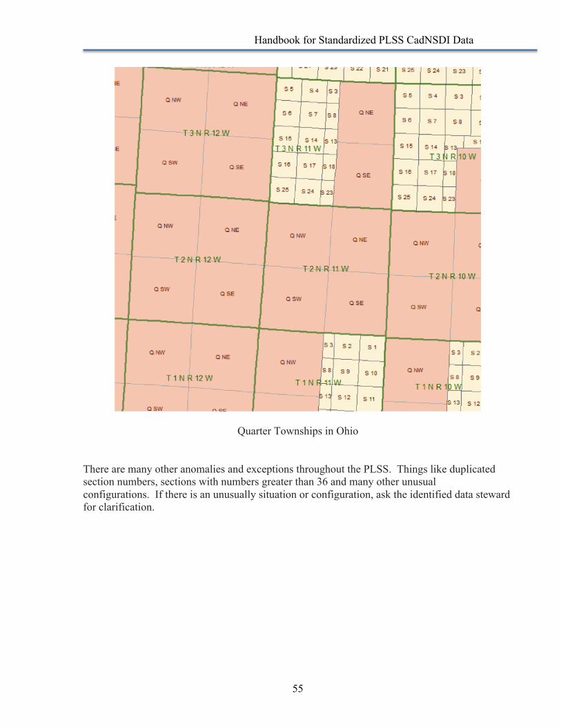
Handbook for Standardized PLSS CadNSDI Data
55
Quarter Townships in Ohio
There are many other anomalies and exceptions throughout the PLSS. Things like duplicated section numbers, sections with numbers greater than 36 and many other unusual configurations. If there is an unusually situation or configuration, ask the identified data steward for clarification.
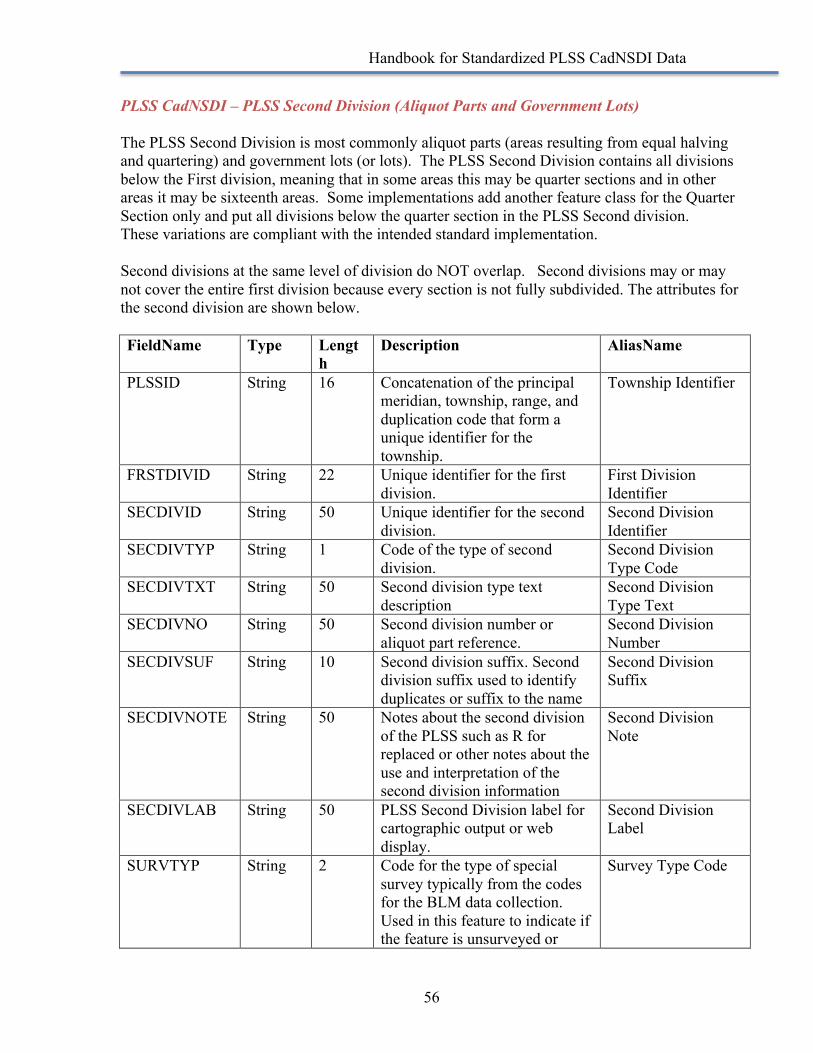
Handbook for Standardized PLSS CadNSDI Data
56
PLSS CadNSDI – PLSS Second Division (Aliquot Parts and Government Lots) The PLSS Second Division is most commonly aliquot parts (areas resulting from equal halving and quartering) and government lots (or lots). The PLSS Second Division contains all divisions below the First division, meaning that in some areas this may be quarter sections and in other areas it may be sixteenth areas. Some implementations add another feature class for the Quarter Section only and put all divisions below the quarter section in the PLSS Second division. These variations are compliant with the intended standard implementation. Second divisions at the same level of division do NOT overlap. Second divisions may or may not cover the entire first division because every section is not fully subdivided. The attributes for the second division are shown below. FieldName Type Lengt
h Description AliasName
PLSSID String 16 Concatenation of the principal meridian, township, range, and duplication code that form a unique identifier for the township.
Township Identifier
FRSTDIVID String 22 Unique identifier for the first division.
First Division Identifier
SECDIVID String 50 Unique identifier for the second division.
Second Division Identifier
SECDIVTYP String 1 Code of the type of second division.
Second Division Type Code
SECDIVTXT String 50 Second division type text description
Second Division Type Text
SECDIVNO String 50 Second division number or aliquot part reference.
Second Division Number
SECDIVSUF String 10 Second division suffix. Second division suffix used to identify duplicates or suffix to the name
Second Division Suffix
SECDIVNOTE String 50 Notes about the second division of the PLSS such as R for replaced or other notes about the use and interpretation of the second division information
Second Division Note
SECDIVLAB String 50 PLSS Second Division label for cartographic output or web display.
Second Division Label
SURVTYP String 2 Code for the type of special survey typically from the codes for the BLM data collection. Used in this feature to indicate if the feature is unsurveyed or
Survey Type Code

Handbook for Standardized PLSS CadNSDI Data
57
unprotracted. SURVTYPTXT String 50 The description of the survey
type code. This is a description of the survey type, or survey status in the case of this feature, without a code.
Survey Type Text
SOURCEDATE Date 8 The date of the source document Source Doc Date SOURCEREF String 100 The reference to the source
document could be a reference to a map or plat or a deed. This could include document type.
Source Doc Link or Reference
RECRDAREATX
String 20 The record or recorded area as a text field. This may include the units of area as well.
Record Area Text
RECRDAREANO
Double 8 The record or recorded area as a numeric field
Record Area Number
GISACRE Double 8 The area of the feature in acres - computed from the GIS, this is not the record area.
GIS Area Acre
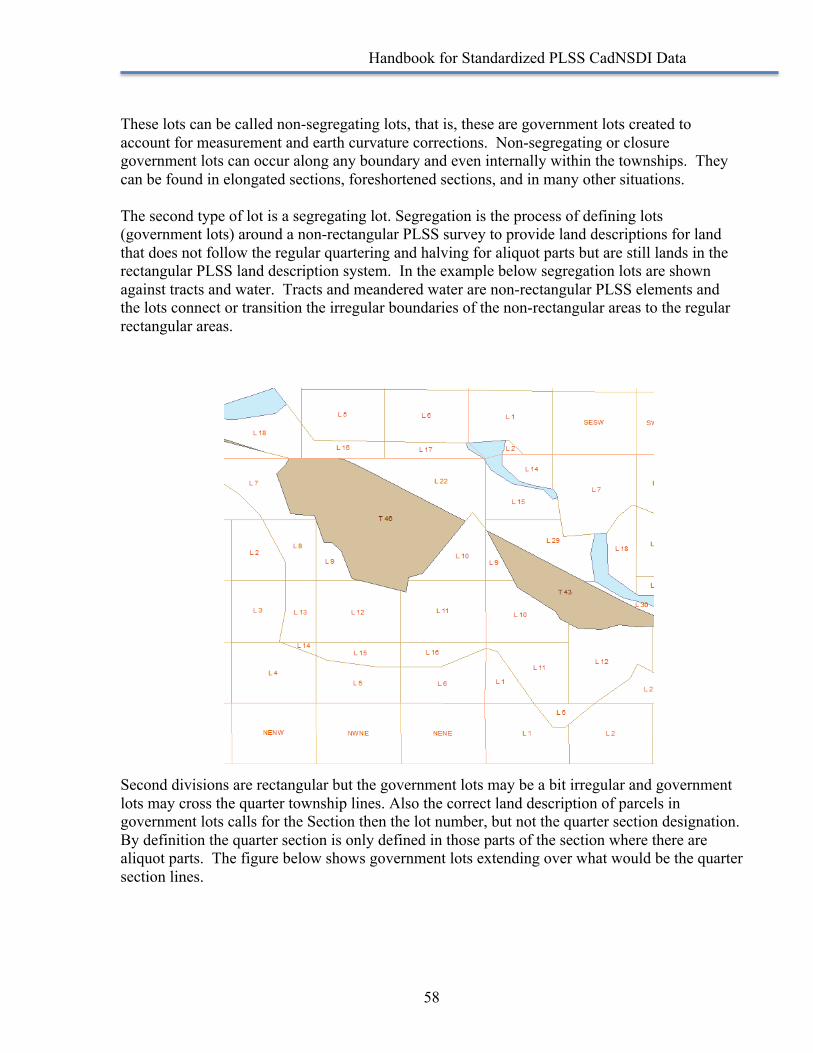
Handbook for Standardized PLSS CadNSDI Data
58
These lots can be called non-segregating lots, that is, these are government lots created to account for measurement and earth curvature corrections. Non-segregating or closure government lots can occur along any boundary and even internally within the townships. They can be found in elongated sections, foreshortened sections, and in many other situations. The second type of lot is a segregating lot. Segregation is the process of defining lots (government lots) around a non-rectangular PLSS survey to provide land descriptions for land that does not follow the regular quartering and halving for aliquot parts but are still lands in the rectangular PLSS land description system. In the example below segregation lots are shown against tracts and water. Tracts and meandered water are non-rectangular PLSS elements and the lots connect or transition the irregular boundaries of the non-rectangular areas to the regular rectangular areas. Second divisions are rectangular but the government lots may be a bit irregular and government lots may cross the quarter township lines. Also the correct land description of parcels in government lots calls for the Section then the lot number, but not the quarter section designation. By definition the quarter section is only defined in those parts of the section where there are aliquot parts. The figure below shows government lots extending over what would be the quarter section lines.
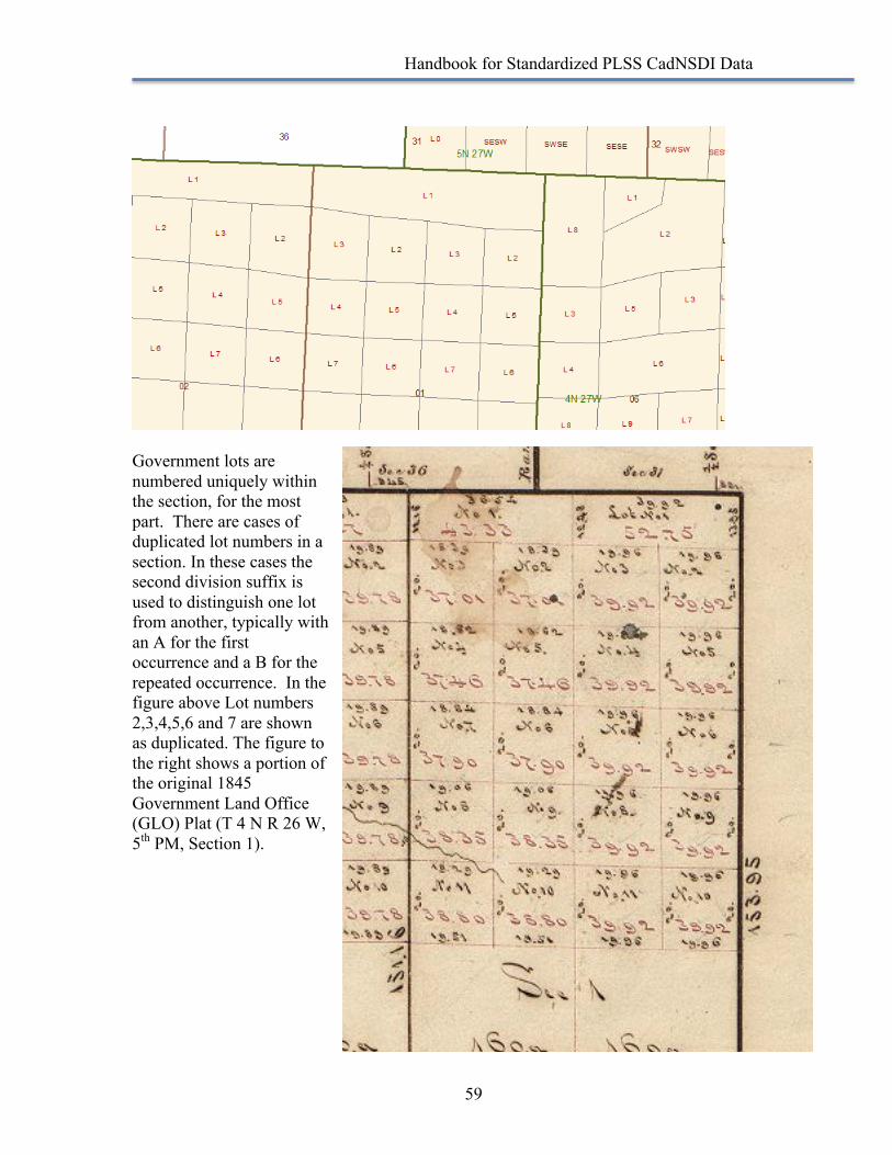
Handbook for Standardized PLSS CadNSDI Data
59
Government lots are numbered uniquely within the section, for the most part. There are cases of duplicated lot numbers in a section. In these cases the second division suffix is used to distinguish one lot from another, typically with an A for the first occurrence and a B for the repeated occurrence. In the figure above Lot numbers 2,3,4,5,6 and 7 are shown as duplicated. The figure to the right shows a portion of the original 1845 Government Land Office (GLO) Plat (T 4 N R 26 W, 5th PM, Section 1).
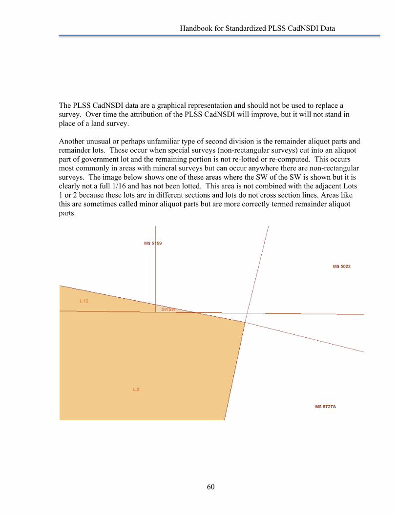
Handbook for Standardized PLSS CadNSDI Data
60
The PLSS CadNSDI data are a graphical representation and should not be used to replace a survey. Over time the attribution of the PLSS CadNSDI will improve, but it will not stand in place of a land survey. Another unusual or perhaps unfamiliar type of second division is the remainder aliquot parts and remainder lots. These occur when special surveys (non-rectangular surveys) cut into an aliquot part of government lot and the remaining portion is not re-lotted or re-computed. This occurs most commonly in areas with mineral surveys but can occur anywhere there are non-rectangular surveys. The image below shows one of these areas where the SW of the SW is shown but it is clearly not a full 1/16 and has not been lotted. This area is not combined with the adjacent Lots 1 or 2 because these lots are in different sections and lots do not cross section lines. Areas like this are sometimes called minor aliquot parts but are more correctly termed remainder aliquot parts.
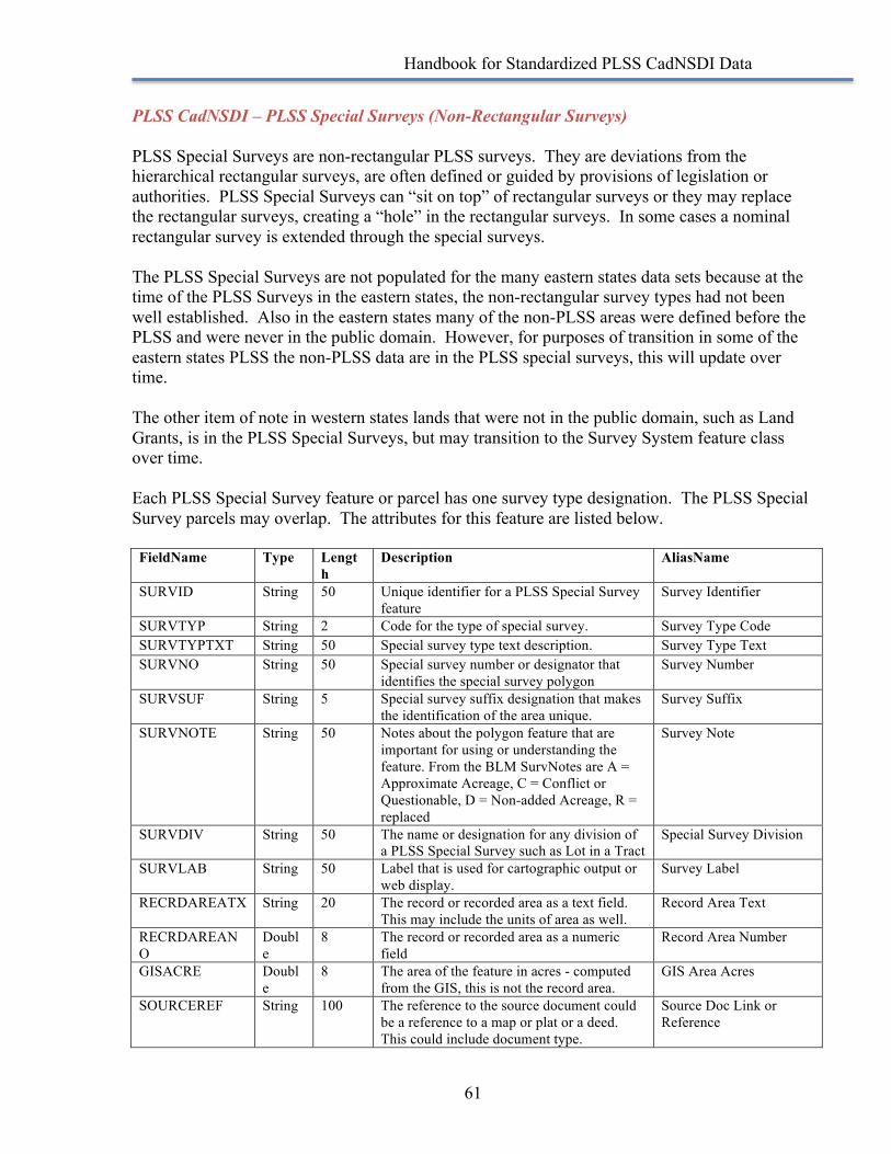
Handbook for Standardized PLSS CadNSDI Data
61
PLSS CadNSDI – PLSS Special Surveys (Non-Rectangular Surveys) PLSS Special Surveys are non-rectangular PLSS surveys. They are deviations from the hierarchical rectangular surveys, are often defined or guided by provisions of legislation or authorities. PLSS Special Surveys can “sit on top” of rectangular surveys or they may replace the rectangular surveys, creating a “hole” in the rectangular surveys. In some cases a nominal rectangular survey is extended through the special surveys. The PLSS Special Surveys are not populated for the many eastern states data sets because at the time of the PLSS Surveys in the eastern states, the non-rectangular survey types had not been well established. Also in the eastern states many of the non-PLSS areas were defined before the PLSS and were never in the public domain. However, for purposes of transition in some of the eastern states PLSS the non-PLSS data are in the PLSS special surveys, this will update over time. The other item of note in western states lands that were not in the public domain, such as Land Grants, is in the PLSS Special Surveys, but may transition to the Survey System feature class over time. Each PLSS Special Survey feature or parcel has one survey type designation. The PLSS Special Survey parcels may overlap. The attributes for this feature are listed below. FieldName Type Lengt
h Description AliasName
SURVID String 50 Unique identifier for a PLSS Special Survey feature
Survey Identifier
SURVTYP String 2 Code for the type of special survey. Survey Type Code SURVTYPTXT String 50 Special survey type text description. Survey Type Text SURVNO String 50 Special survey number or designator that
identifies the special survey polygon Survey Number
SURVSUF String 5 Special survey suffix designation that makes the identification of the area unique.
Survey Suffix
SURVNOTE String 50 Notes about the polygon feature that are important for using or understanding the feature. From the BLM SurvNotes are A = Approximate Acreage, C = Conflict or Questionable, D = Non-added Acreage, R = replaced
Survey Note
SURVDIV String 50 The name or designation for any division of a PLSS Special Survey such as Lot in a Tract
Special Survey Division
SURVLAB String 50 Label that is used for cartographic output or web display.
Survey Label
RECRDAREATX String 20 The record or recorded area as a text field. This may include the units of area as well.
Record Area Text
RECRDAREANO
Double
8 The record or recorded area as a numeric field
Record Area Number
GISACRE Double
8 The area of the feature in acres - computed from the GIS, this is not the record area.
GIS Area Acres
SOURCEREF String 100 The reference to the source document could be a reference to a map or plat or a deed. This could include document type.
Source Doc Link or Reference
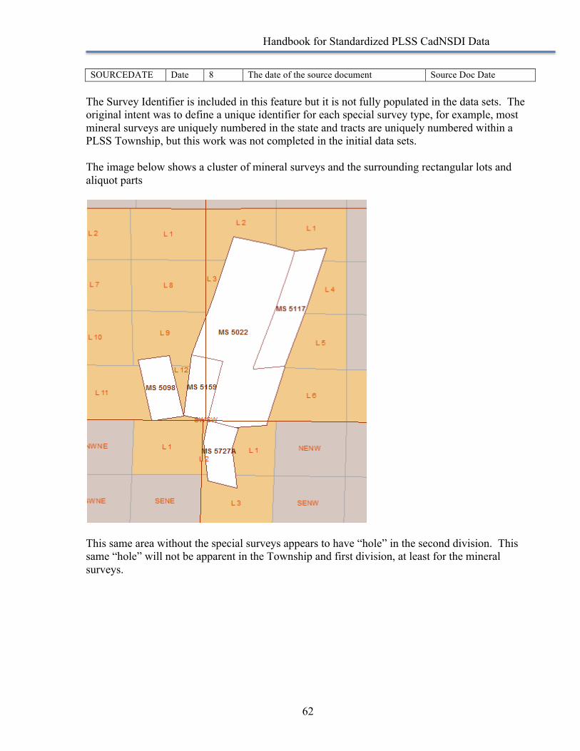
Handbook for Standardized PLSS CadNSDI Data
62
SOURCEDATE Date 8 The date of the source document Source Doc Date The Survey Identifier is included in this feature but it is not fully populated in the data sets. The original intent was to define a unique identifier for each special survey type, for example, most mineral surveys are uniquely numbered in the state and tracts are uniquely numbered within a PLSS Township, but this work was not completed in the initial data sets. The image below shows a cluster of mineral surveys and the surrounding rectangular lots and aliquot parts
This same area without the special surveys appears to have “hole” in the second division. This same “hole” will not be apparent in the Township and first division, at least for the mineral surveys.
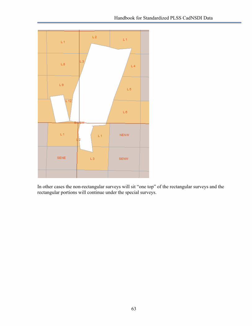
Handbook for Standardized PLSS CadNSDI Data
63
In other cases the non-rectangular surveys will sit “one top” of the rectangular surveys and the rectangular portions will continue under the special surveys.
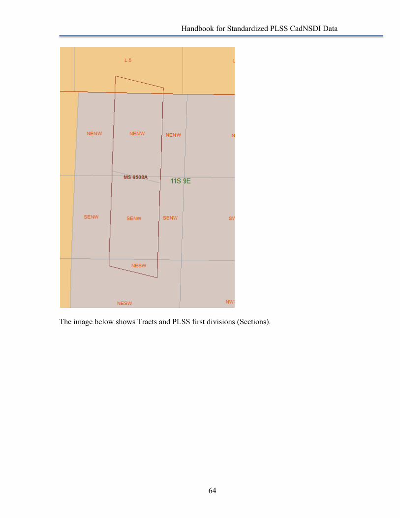
Handbook for Standardized PLSS CadNSDI Data
64
The image below shows Tracts and PLSS first divisions (Sections).
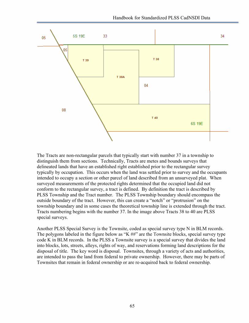
Handbook for Standardized PLSS CadNSDI Data
65
The Tracts are non-rectangular parcels that typically start with number 37 in a township to distinguish them from sections. Technically, Tracts are metes and bounds surveys that delineated lands that have an established right established prior to the rectangular survey typically by occupation. This occurs when the land was settled prior to survey and the occupants intended to occupy a section or other parcel of land described from an unsurveyed plat. When surveyed measurements of the protected rights determined that the occupied land did not conform to the rectangular survey, a tract is defined. By definition the tract is described by PLSS Township and the Tract number. The PLSS Township boundary should encompass the outside boundary of the tract. However, this can create a “notch” or “protrusion” on the township boundary and in some cases the theoretical township line is extended through the tract. Tracts numbering begins with the number 37. In the image above Tracts 38 to 40 are PLSS special surveys. Another PLSS Special Survey is the Townsite, coded as special survey type N in BLM records. The polygons labeled in the figure below as “K ##” are the Townsite blocks, special survey type code K in BLM records. In the PLSS a Townsite survey is a special survey that divides the land into blocks, lots, streets, alleys, rights of way, and reservations forming land descriptions for the disposal of title. The key word is disposal. Townsites, through a variety of acts and authorities, are intended to pass the land from federal to private ownership. However, there may be parts of Townsites that remain in federal ownership or are re-acquired back to federal ownership.
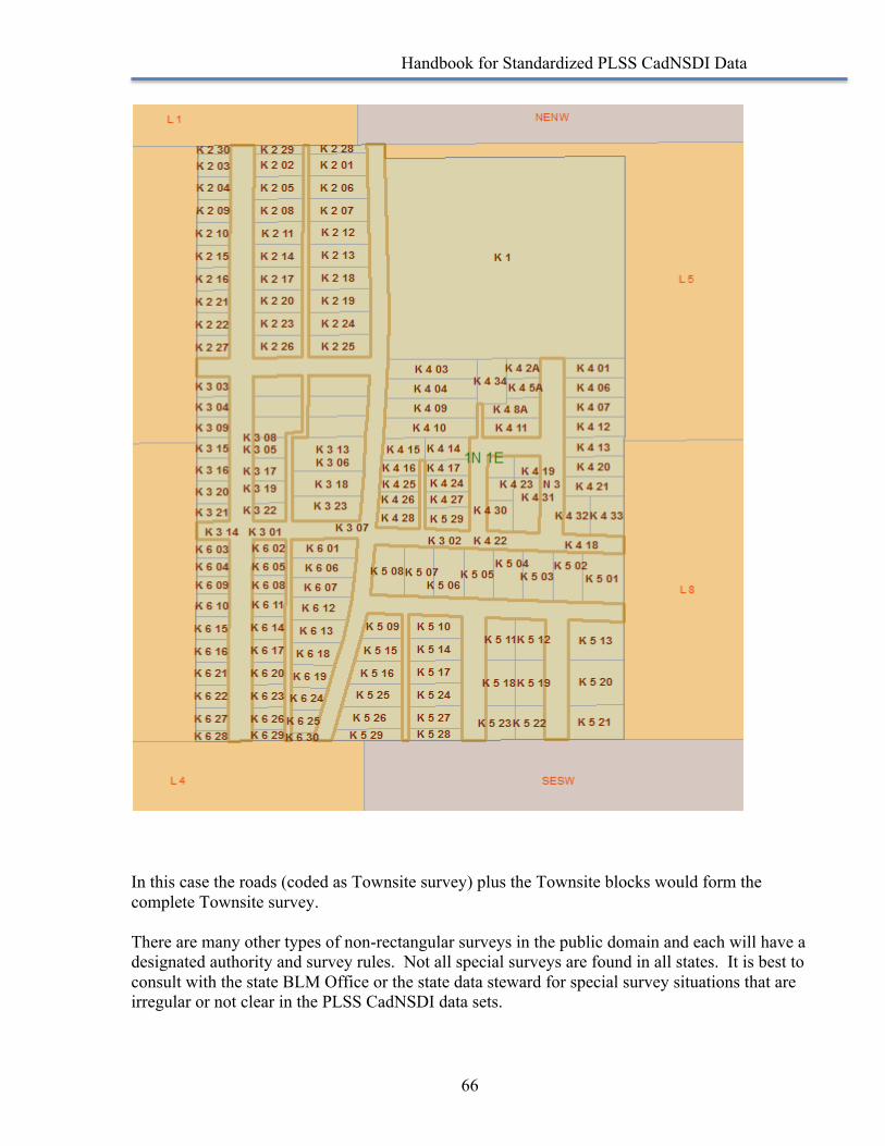
Handbook for Standardized PLSS CadNSDI Data
66
In this case the roads (coded as Townsite survey) plus the Townsite blocks would form the complete Townsite survey. There are many other types of non-rectangular surveys in the public domain and each will have a designated authority and survey rules. Not all special surveys are found in all states. It is best to consult with the state BLM Office or the state data steward for special survey situations that are irregular or not clear in the PLSS CadNSDI data sets.
Handbook for Standardized PLSS CadNSDI Data
67
PLSS CadNSDI – Meandered Water MeanderedwaterisNOThydrography.TheseareareasofwaterthataredefinedfrommeanderlinesofthePLSS,typicallyasshownontheoriginalGovernmentLandOffice(GLO)orrecentBLMsurveyplats.Thesearenottheofficialrepresentationsofcoastorwaterlinesandarerepresentationsofthelinesmarkedbythesurveyalongtheboundariesofmeanderedwateratthetimeofsurvey There is no attribution with the meandered water feature class other than a special survey type code indicating it is water. The meandered water is perhaps one of the more confusing feature classes in the PLSS CadNSDI. The meander lines were run on original surveys to separate the uplands from the water. In some cases these lines became legal boundary lines and are called out in land descriptions. In other cases the water’s edge is the legal boundary and the meander line is only an approximation of the water. If the PLSS CadNSDI data set originated from digitized USGS topographic quad sheets, which is relatively common I the eastern states, then the meandered water feature is empty, unless a survey plat or local data set has been used to update the original data set. This is because when comparing the digitized PLSS to survey plats it was noted that hydrography, water captured from a source other than the survey plat, often took precedence over the PLSS meandered water. In some cases areas delineated as land in the original survey were omitted and in other cases land was extended to meet current hydrography. It is critically important that the use of the water boundaries in the PLSS CadNSDI be used as a general reference only and the specific information about basis of land descriptions and the intended representation of water versus upland be well understood for any legal applications. The graphic below illustrates the many varied ways that meandered water may be presented in the PLSS CadNSDI
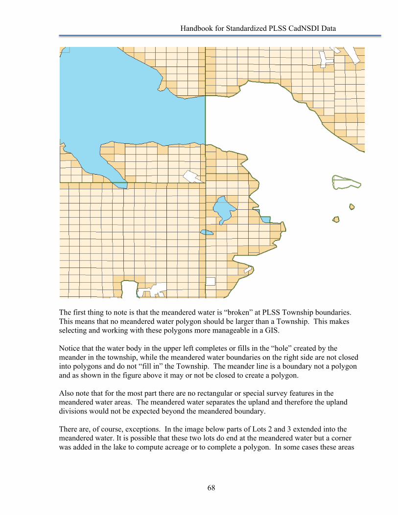
Handbook for Standardized PLSS CadNSDI Data
68
The first thing to note is that the meandered water is “broken” at PLSS Township boundaries. This means that no meandered water polygon should be larger than a Township. This makes selecting and working with these polygons more manageable in a GIS. Notice that the water body in the upper left completes or fills in the “hole” created by the meander in the township, while the meandered water boundaries on the right side are not closed into polygons and do not “fill in” the Township. The meander line is a boundary not a polygon and as shown in the figure above it may or not be closed to create a polygon. Also note that for the most part there are no rectangular or special survey features in the meandered water areas. The meandered water separates the upland and therefore the upland divisions would not be expected beyond the meandered boundary. There are, of course, exceptions. In the image below parts of Lots 2 and 3 extended into the meandered water. It is possible that these two lots do end at the meandered water but a corner was added in the lake to compute acreage or to complete a polygon. In some cases these areas
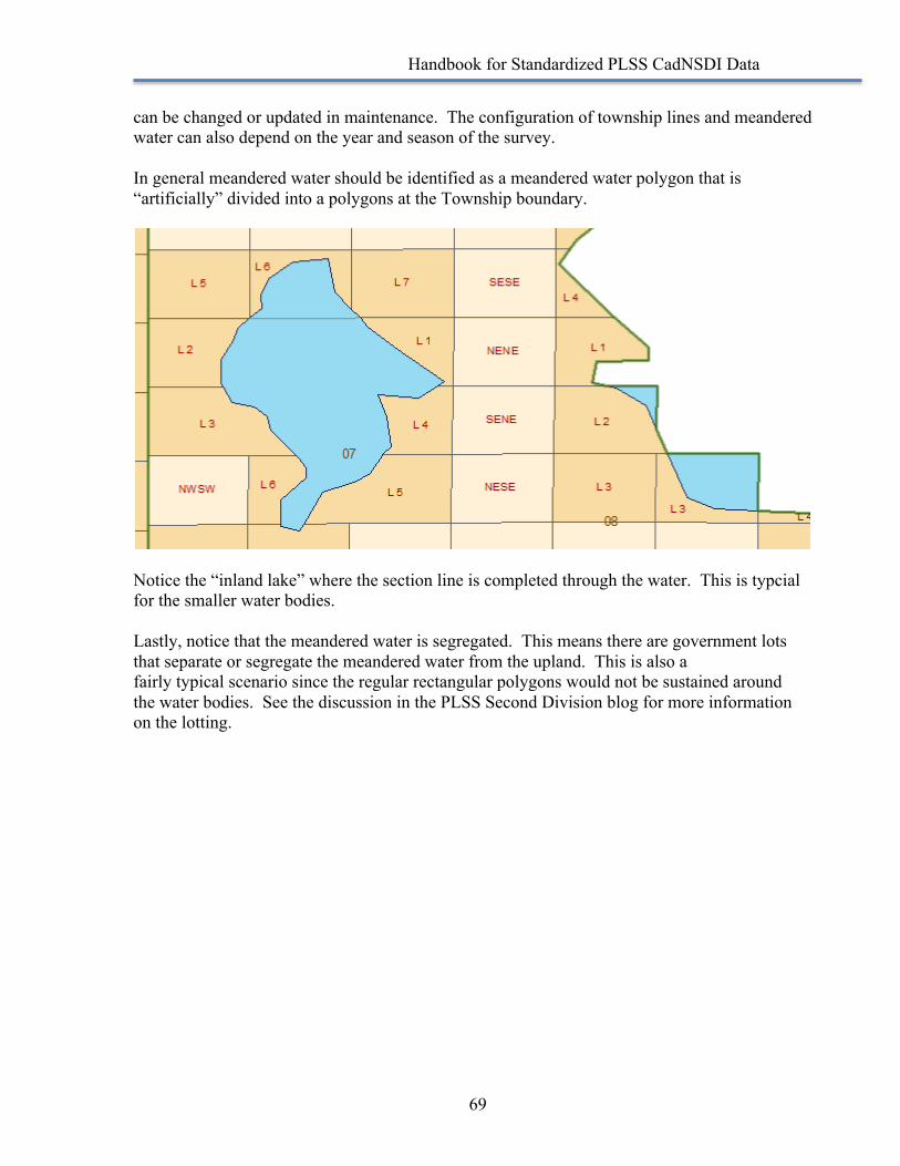
Handbook for Standardized PLSS CadNSDI Data
69
can be changed or updated in maintenance. The configuration of township lines and meandered water can also depend on the year and season of the survey. In general meandered water should be identified as a meandered water polygon that is “artificially” divided into a polygons at the Township boundary.
Notice the “inland lake” where the section line is completed through the water. This is typcial for the smaller water bodies. Lastly, notice that the meandered water is segregated. This means there are government lots that separate or segregate the meandered water from the upland. This is also a fairly typical scenario since the regular rectangular polygons would not be sustained around the water bodies. See the discussion in the PLSS Second Division blog for more information on the lotting.

Handbook for Standardized PLSS CadNSDI Data
70
PLSS CadNSDI – PLSS Special Surveys - Mineral Surveys A Mineral Survey is a type of PLSS Special Survey. In the seventh document PLSS Special Surveys, non-rectangular PLSS surveys, were discussed in general. The non-rectangular surveys are deviations from the hierarchical rectangular surveys, are often defined or guided by provisions of legislation or authorities. PLSS Special Surveys can “sit on top” of rectangular surveys or they may replace the rectangular surveys, creating a “hole” in the rectangular surveys. In some cases a nominal rectangular survey is extended through the special surveys. Mineral Surveys
Mineral surveys are made to mark the legal boundaries of mineral deposits or ore-bearing formations on the public domain where the boundaries are determined by lines other than the normal subdivision of the public lands. These surveys include the usual surveying technical procedures and the examination and documentation of various reports and certificates necessary to substantiate legal procedures. (http://www.blm.gov/cadastral/minprocedures/mineralguide.htm#)
The manual cited above and several other mineral survey guides are available on line. This discussion does not cover the survey, recording, or researching procedures. This document describes how mineral surveys are portrayed in the PLSS CadNSDI and some of the nuances of using this special survey type in the PLSS CadNSDI. Brief Background The mineral survey plat and survey notes are sued to compile the polygons seen in the PLSS CadNSDI. Mineral Surveys were created and recorded to establish a right of entry to extract or process a mineral deposit. Most mineral surveys are composed of a set of mining claims (claims). These can be lode claims, placer claims or mile site claims. The mineral survey is collection of these claims recorded together, but the rights and patents (conveyances out of the federal government to the claimant) occur at the claim level, not the mineral survey level. Much like a traditional subdivision has individual lots, a mineral survey has claims, a division of the mineral survey, and the operational unit is the claim within the survey. The General land Office (GLO) or BLM assigns numbers to the mineral surveys. Historically, they are uniquely numbered within a mining district and more recently most states have renumbered the mineral surveys providing a unique mineral survey number within the state. Colorado is the exception and there are duplicated mineral surveys within the state. The claims within the mineral survey are named or numbered. The claim name or number can be added to records captured in the parcel fabric and over time it is expected that more of this information will be included in the PLSS CadNSDI. In some PLSS CadNSDI data sets the claim lines are included the PLSS Intersected feature class, however, for legal uses, users should consult the original records or the state BLM Office.
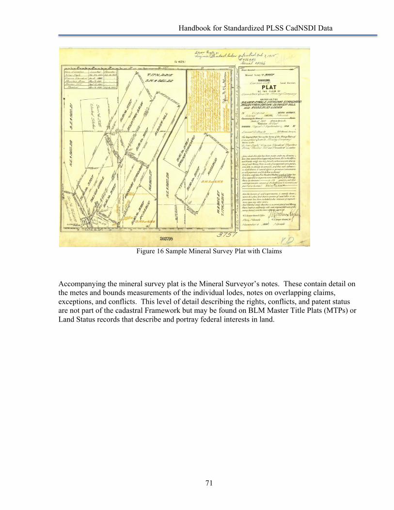
Handbook for Standardized PLSS CadNSDI Data
71
Figure 16 Sample Mineral Survey Plat with Claims
Accompanying the mineral survey plat is the Mineral Surveyor’s notes. These contain detail on the metes and bounds measurements of the individual lodes, notes on overlapping claims, exceptions, and conflicts. This level of detail describing the rights, conflicts, and patent status are not part of the cadastral Framework but may be found on BLM Master Title Plats (MTPs) or Land Status records that describe and portray federal interests in land.
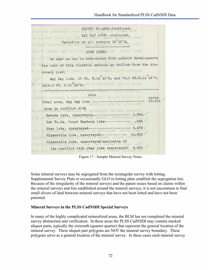
Handbook for Standardized PLSS CadNSDI Data
72
Figure 17 - Sample Mineral Survey Notes
Some mineral surveys may be segregated from the rectangular survey with lotting. Supplemental Survey Plats or occasionally GLO re-lotting plats establish the segregation lots. Because of the irregularity of the mineral surveys and the patent issues based on claims within the mineral surveys and lots established around the mineral surveys, it is not uncommon to find small slivers of land between mineral surveys that have not been lotted and have not been patented. Mineral Surveys in the PLSS CadNSDI Special Surveys In many of the highly complicated mineralized areas, the BLM has not completed the mineral survey abstraction and verification. In these areas the PLSS CadNSDI may contain stacked aliquot parts, typically the sixteenth (quarter quarter) that represent the general location of the mineral survey. These aliquot part polygons are NOT the mineral survey boundary. These polygons serve as a general location of the mineral survey. In these cases each mineral survey
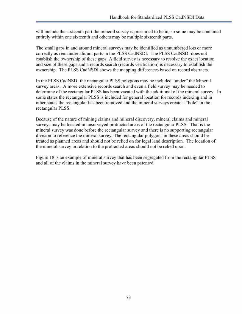
Handbook for Standardized PLSS CadNSDI Data
73
will include the sixteenth part the mineral survey is presumed to be in, so some may be contained entirely within one sixteenth and others may be multiple sixteenth parts. The small gaps in and around mineral surveys may be identified as unnumbered lots or more correctly as remainder aliquot parts in the PLSS CadNSDI. The PLSS CadNSDI does not establish the ownership of these gaps. A field survey is necessary to resolve the exact location and size of these gaps and a records search (records verification) is necessary to establish the ownership. The PLSS CadNSDI shows the mapping differences based on record abstracts. In the PLSS CadNSDI the rectangular PLSS polygons may be included “under” the Mineral survey areas. A more extensive records search and even a field survey may be needed to determine of the rectangular PLSS has been vacated with the additional of the mineral survey. In some states the rectangular PLSS is included for general location for records indexing and in other states the rectangular has been removed and the mineral surveys create a “hole” in the rectangular PLSS. Because of the nature of mining claims and mineral discovery, mineral claims and mineral surveys may be located in unsurveyed protracted areas of the rectangular PLSS. That is the mineral survey was done before the rectangular survey and there is no supporting rectangular division to reference the mineral survey. The rectangular polygons in these areas should be treated as planned areas and should not be relied on for legal land description. The location of the mineral survey in relation to the protracted areas should not be relied upon. Figure 18 is an example of mineral survey that has been segregated from the rectangular PLSS and all of the claims in the mineral survey have been patented.
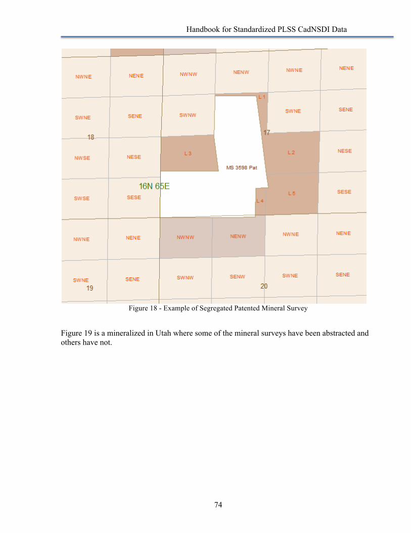
Handbook for Standardized PLSS CadNSDI Data
74
Figure 18 - Example of Segregated Patented Mineral Survey
Figure 19 is a mineralized in Utah where some of the mineral surveys have been abstracted and others have not.
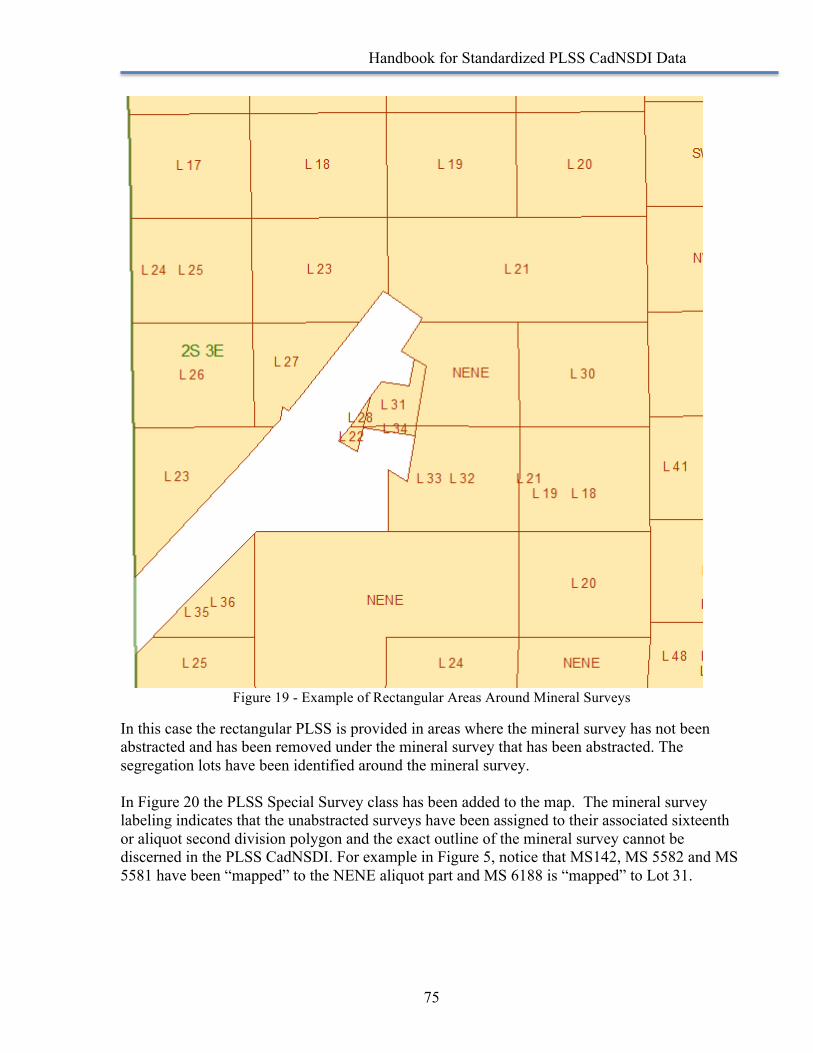
Handbook for Standardized PLSS CadNSDI Data
75
Figure 19 - Example of Rectangular Areas Around Mineral Surveys
In this case the rectangular PLSS is provided in areas where the mineral survey has not been abstracted and has been removed under the mineral survey that has been abstracted. The segregation lots have been identified around the mineral survey. In Figure 20 the PLSS Special Survey class has been added to the map. The mineral survey labeling indicates that the unabstracted surveys have been assigned to their associated sixteenth or aliquot second division polygon and the exact outline of the mineral survey cannot be discerned in the PLSS CadNSDI. For example in Figure 5, notice that MS142, MS 5582 and MS 5581 have been “mapped” to the NENE aliquot part and MS 6188 is “mapped” to Lot 31.
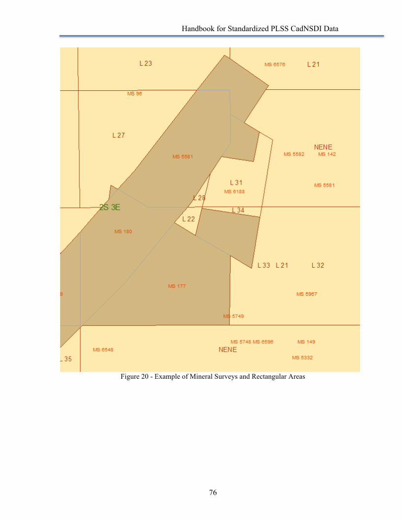
Handbook for Standardized PLSS CadNSDI Data
76
Figure 20 - Example of Mineral Surveys and Rectangular Areas
Handbook for Standardized PLSS CadNSDI Data
77
Some References There are many Internet published references for mineral survey procedures and the nuances and details for abstracting and research mineral survey records. The following is a small sample of some resources. Mineral Surveys Procedures Guide (http://www.blm.gov/cadastral/minprocedures/mineralguide.htm#)
This is a good guide on the field survey and reporting requirements and methods. Searching for BLM Records (http://www.nv.blm.gov/LandRecords/help.html)
This is a web page hosted by the Nevada BLM State Office that provides some guidance on how to search for federal land records
2009 Manual of Surveying Instruction (http://www.cfeds.org/docs/sml/ManualOfSurveyingInstructions2009_060414.pdf)
Chapter 10 of the most recent version of the Manual of Surveying Instruction discusses the elements and surveying requirements for mineral surveys.