Embed Size (px)
Citation preview

Foothill Yellow-Legged Frog and Sierra Nevada Yellow-Legged Frog
Standard Operating Procedures for
Visual Encounter Surveys
Modified for Drum-Spaulding and Yuba-Bear Relicensing PG&E 2007
The following standard operating procedures (SOPs) were originally developed by Pacific Gas &
Electric Co. to describe the parameters and data collection methods for completing visual
encounter surveys (VES) in lotic waters for foothill yellow-legged frog (FYLF), and were
modified to also address Sierra Nevada yellow-legged frog (SNYLF) for the Drum-Spaulding
and Yuba-Bear projects. All parameters described in this SOP are to be collected during
surveys.
1.0 GENERAL PARAMETERS AND METHODS
1. All measurements should be recorded in metric units unless otherwise indicated.
2. Many of the data sheet parameters will be recorded as a numerical code. A guide for these
codes is included in the following SOPs, and a separate parameter code key is included for
use in the field surveys in concert with the datasheets.
3. For consistency in data collection, surveys will be started and completed by the same crew
members.
4. Where practicable, a pair of surveyors will initiate the VES at the bottom of the site and
survey upstream. During the breeding season surveys one or two surveyors, wearing
polarized sunglasses, will walk along the shoreline and wade in the shallows using a viewbox
and binoculars to search for all life-stages. Another surveyor will snorkel. The wading
surveyors will use the binoculars to search the shoreline ahead of them in an attempt to
identify animals before they hide or escape and will use the viewbox to assist in searching the
shallow water areas that the snorkel surveyor cannot investigate. All surveyors will use their
hands to feel under overhangs of bedrock and boulders where they cannot see. The wading
surveyors will use a carefully gauged zig-zag pattern to search the shallows and will
communicate with the snorkeler to ensure that the site is thoroughly surveyed in one pass.
During surveys performed outside of the breeding season both surveyors will wade, in the
manner described above, in order to survey thoroughly in one pass.
5. All observations and comments on amphibians and aquatic habitat will be recorded on the
VES data sheets. Each crew member will have a field notebook. Notebooks will be
identified with the crew member’s name and initials (a three letter code from the first letter of
the first, middle, and last name of the crew member) and numbered sequentially in the order
used. The notebook will be used to record observations and comments on habitat conditions
not included on the data sheet. Entries on all pages should be dated.
6. Right bank and left bank will be designated facing in a downstream direction.

7. Time entries should be recorded in military format (e.g., 4:00 PM is 1600).
8. Distance and length measurements should be taken with a hip chain, metric tape, or range
finder.
9. Velocity measurements should be made with a Marsh-McBurney (or similar) flow meter.
Record velocity measurements to the nearest cm/sec. Depth at which velocity measurements
are taken will be measured (i.e. bottom, 0.6 mid-column, or surface). For standardization
with hydraulic modeling efforts, 0.6 mid-column depth should be included as well as a focal
animal velocity.
10. Weather conditions: VES should generally be conducted on warm, sunny days with light
winds (≤ 20 mph) when the probability of observing frogs out in the open is greatest.
Surveys should be avoided on cold or very windy days (> 20 mph, depending on the
exposure of the habitat). On extremely hot days, surveys should be conducted during the
cooler portion of the day (i.e., morning and late afternoon to evening).
11. Poor weather conditions may preclude conducting VES during all or a portion of the day. If
field conditions are safe, site habitat assessments may still be completed.
12. Amphibian surveys should be performed at the time of day the target species is most likely to
be observed. In general, surveys should be conducted between about 0900 and 1900.
However, this is dependent on the time of year and local weather conditions. If significant
changes in weather occur during the survey (e.g., significant drop in temperature or increase
in wind speed), the survey should be discontinued.
13. Polarized sunglasses are highly recommended to reduce glare and increase visibility at
aquatic sites. View boxes or a snorkeling mask should be used in areas where glare and/or
surface ripples and/or turbidity limit visibility.
14. Photographs will be taken of FYLF microhabitats, egg masses, tadpoles, etc. should follow
the methods outlined in the main text of the study plan. Photographs should be logged on
field data sheets and additional notes kept in the field notebook.
15. If available, copies of aerial photographs should be used to denote site boundaries, area
surveyed, search pattern, transect locations, and prominent habitat features. If not available,
a site drawing should be included on the back of the site habitat assessment data sheet. UTM
coordinates should be collected at the location of egg masses, tadpoles, and post-
metamorphic frogs in order to map life-stages in the office.
16. Care should always be exercised not to disturb amphibian habitat or amphibians any more
than is necessary to conduct the surveys. Should an animal be seen escaping and hiding
underneath a cover object (e.g., bark, logs, rocks, vegetation), the objects should be carefully
lifted or tipped up and replaced in their original positions before replacing amphibians.
During tadpole surveys cover objects will only be lifted if a tadpole escapes and hides under
one, but algae and detritus will be sifted through in an attempt to flush animals into the open.
17. When capturing and handling amphibians, the surveyor’s hands should be clean (no sun
protection products, insect repellent, or other lotions). In addition, the use of surgical gloves
for handling frogs will reduce the likelihood of transmitting diseases. Surveyors should limit
the time that amphibians are handled, and should release animals at the point of capture. If
handling amphibians for an extended period is necessary for identification purposes or to

take photographs, a clean plastic bag or jar partially filled with ambient water may be used
for holding animals for a short period of time (< 5 min.). When conducting a formal VES,
any time expended identifying or capturing animals should not be included as part of the total
time spent surveying.
18. To decrease the possibility of transmission of infectious agents (chytrid fungus, or other
fungal or bacterial infections) from handling potentially infected frogs, the following
procedures developed by Speare et al. (2004) and the Declining Amphibian Populations Task
Force should be utilized during all field surveys. The following protocols are also the
accepted procedures being used by the U. S. Forest Service.
With increasing focus on amphibians and field surveys to identify and document the presence
and distribution of special-status species (e.g., FYLF) and determine utilization of habitats,
there is a high risk that field crews could spread disease among other amphibian populations.
There is growing evidence that the occurrence of the chytrid fungus is increasing in the
Sierra Nevada. Consequently, it is essential that field crews follow a standard protocol for
cleaning equipment before conducting surveys in other drainages. It is not necessary to clean
equipment between sites within drainages.
In tadpoles, the chytrid fungus attacks the keratin tooth rows and horny beak. In frogs, the
fungus is associated with the keratinized layers of the skin. In the field, signs of infection
may be observed by examining the mouths of tadpoles. Infected individuals will typically
have: tooth rows that are mostly or entirely missing; beaks that lack black pigment; and
occasionally slight deformities in the soft, fleshy parts of the mouth in addition to the above
conditions.
When conducting surveys for FYLF (or other amphibians), there are two methods for
handling frogs that will significantly reduce the potential for transmitting infectious agents
between frogs. These are: 1) the use of disposable gloves (e.g., Surgigloves), changing gloves
after handling each animal; and 2) the capture and handling of frogs using new plastic bags
for each animal. In both cases, the frogs do not come in contact with the surveyor’s skin or
clothing. When frogs are difficult to catch, the surveyor’s skin or clothing may come in
contact with the frog. If this occurs, all contact surfaces should be cleaned with an antiseptic
solution. Used gloves, plastic bags, nets, and/or jars used to capture or hold frogs should not
come in contact with clean equipment. Several nets, plastic bags, and gloves should be
available for each site. When the survey is completed, dispose of all gloves and plastic bags,
and clean other equipment, hands, and clothing with hospital grade disinfectant or 70%
ethanol.
To reduce the risk of spreading infections to other areas, clean hands, clothes, boots, and
potentially vehicle tires if contact with aquatic habitats occurs. Bleach can be used to clean
and disinfect equipment, but it loses effectiveness over time and should be replaced after a
month or two. Quat 128 disinfecting agent is a good alternative to bleach (Johnson et al.
2003). Before leaving a site, remove mud, organisms, algae, and other debris from nets,
boots, vehicle tires, and other gear. Do not clean equipment in the immediate vicinity of
aquatic habitats. Be sure to rinse all gear thoroughly with fresh water after cleaning. Refer
to Speare et al. (1998) for more information.
19. Voucher specimens may be collected if animals assessed for chytrid appear positive and/or if
animals exhibit abnormalities. Collect only as many specimens as needed to complete the

identification. If fewer than ten FYLF are found at a site, they should not be collected, and
no more than two specimens should be taken at any site. The specimens should be placed in
a glass or Nalgene container with the anesthetic solution of 1 ml tricaine methanosulphonate
(MS222) and 500 ml water buffered with 3.5 g sodium bicarbonate for 15+ minutes, and then
placed in a glass or Nalgene container with 10% isopropyl alcohol (or 10% ethanol) for
temporary storage. The final storage solution should be 70% ethanol. The taking of voucher
specimens will only be performed when absolutely necessary.
20. Field data sheets will be QA/QC checked as each sheet is completed. The reviewer’s initials
and the review date will be recorded at the bottom of the data sheet.
21. Total distance covered and apportionment of VES samples among habitat strata should be
accounted for on a reach wide tally sheet. The tally sheet will be prepared prior to initiating
field surveys and will be QA/QC checked at the end of each survey (egg mass, tadpole, etc.)
to ensure that sampling has accounted for all habitat strata.
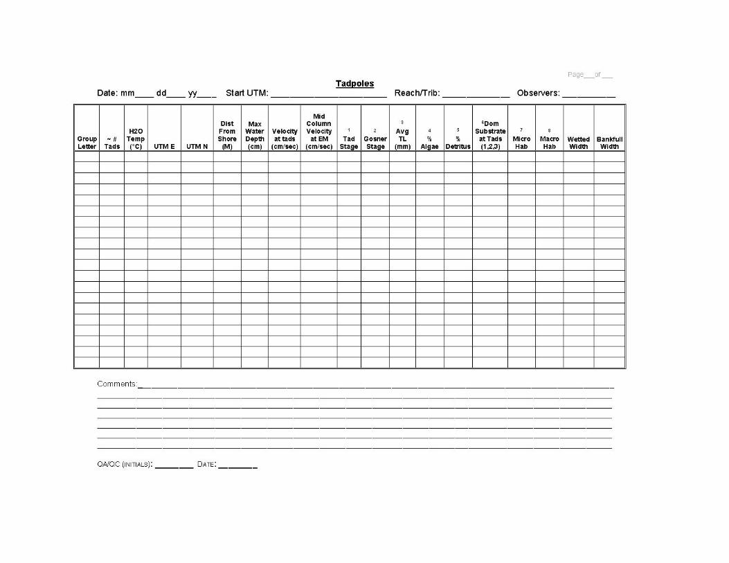
2.0 UPPER PORTION OF EACH DATA SHEET:
Below are instructions for completing the river and creek VES data sheets, beginning with the
upper left corner. There are specific data sheets for each major life stage: one for egg masses,
one for tadpoles, and one for post-metamorphic frogs. The instructions for each version are
included below.
Date – Record the date of the survey in the following format: month / day / year (e.g., 07/02/01).
Start UTMs – Record the UTM data of the beginning location for each survey day. Record the
UTM easting first and UTM northing second (e.g. 704250, 3391520).
End UTMs - Record the UTM data of the end location for each survey day. Record the UTM
easting first and UTM northing second (e.g. 704250, 3391520).
Reach – Record the reach name. If surveying a tributary to a reach, record the tributary name or
code. For tributaries, also provide approximate survey location along the river reach. Include a
landmark or other indicator provided on the USGS topographic map.
Observers – The initials of all participating VES team members should appear on the data sheet.
The initials of the team member filling out the data sheet should be noted first.
Survey Method – Indicate the number of surveyors and the search methods used for the VES –
Tandem should indicate two or more surveyors on the same side of the creek, separate is used to
indicate surveyors working on banks opposite each other. Indicate how many surveyors are
snorkeling and which banks, river right (RB) or river left (LB), are being surveyed by the
snorkeler/s. Indicate how many surveyors are wading and which banks, river right (RB) or river
left (LB), are being surveyed by the wader/s.
Start Time – Record the time the VES is started.
End Time – Record the time the VES is completed.

Actual VES Time – Record the time actually spent conducting the VES. This represents the
time spent between the start and end time that is exclusively expended searching for FYLF.
Time spent filling out VES data sheets, and capturing or identifying animals is included within
the start and end times, but is not included in the actual VES time. A stopwatch should be used
to track actual VES time; this variable should not be estimated.
Start Air Temp. – Measure and record starting air temperature. Readings should be taken in the
shade at chest height and should be recorded in degrees Celsius.
End Air Temp. – Measure and record ending air temperature. Readings should be taken in the
shade at chest height and should be recorded in degrees Celsius.
Water Temp. – Water temperatures should be recorded in degrees Celsius. Creek water
temperatures should be obtained along the shoreline in edgewater areas, and at a location further
from shore that is representative of the main stream temperature. In lentic habitats (side pools,
scour pools, etc.) within the creek, water temperatures should be representative of the habitat.
Discharge – Estimate the flow in cubic feet per second (cfs). Where available, use stream gage
data.
Search Area Length – Record the total length of the creek surveyed during the day of survey.
This can be measured throughout the survey day using a rangefinder or may be determined in the
office using the UTM coordinates. This measurement should include all areas, even those that
are not considered suitable habitat. Both banks are always included in the total site length.
Search Area Width – Record the average width of the area that is surveyed. This should be an
estimate of the average creek width that was included in the VES.
Total Area Searched – This represents the survey area length times the average survey area
width. Total area should be recorded in square meters and may be calculated in the office.
Site Visit – Indicate if this is the first, second, third, or fourth site visit during the course of one
year.
Weather Past 24 Hours – Indicate what the weather conditions were over the last 24-hour
period. Include sky conditions and wind conditions.
Weather Today– Indicate what weather conditions were experienced during the VES. Include
sky and wind conditions.

3.0 MIDDLE PORTION OF DATA SHEETS:
3.1 Data Sheet Parameters Specific to Egg Masses
On the data sheet for egg masses, use the following instructions for recording data in the 19
columns that appear in the table in the center of the data sheet.
Egg Mass Group Letter – A letter should be assigned to each specific egg mass, or clustered
group of egg masses, that is observed during the VES. These letters should be sequential from
the downstream end of the site to the upstream end. If more than 26 egg masses or groups of egg
masses are observed at a given site, continue to assign Egg Mass Letters as follows: egg mass 26
= Z, 27 = AA, 28 = BB, etc.
Number of Egg Masses – Record the number of egg masses at a given location. For a group of
egg masses, indicate which egg mass pertains to the data being collected. For example: If three
egg masses are found for “Group A”, record the number as 1 of 3, 2 of 3, and 3 of 3, starting at
the downstream end of the egg mass group and continuing upstream. If necessary, sketch the
egg mass group on the back of the data sheet.
Water Temperature – Record the water temperature in degrees Celsius where each egg mass is
located.
UTM E – While using a GPS unit, record the UTM Easting
UTM N – While using a GPS unit, record the UTM Northing.
Distance From Shore – Measure the distance of each egg mass from the water's edge. The
distance should be measured with a metric tape or ruler.
Depth of Egg Mass – Record the water depth from the surface to the center of each egg mass.
The water depth should be measured with a metric stick or ruler.
Maximum Water Depth – Record the total water depth where the egg mass is located. The
water depth should be measured with a metric stick or ruler.
Velocity at Egg Mass – Measure the water velocity (in cm/sec) in the water column as close to
the egg mass as possible. The reading should be taken adjacent to the center of the egg mass.
This measurement should represent the average flow velocity at the location of the egg mass at
the time of the VES.
Mid-column Velocity at Egg Mass – Measure the water velocity (in cm/sec) at a 0.6 mid-
column velocity. The reading should be taken at 0.6 depth from waters surface.

Egg Mass Attachment Substrate – Record the specific substrate category to which the egg
mass is attached. Size classifications for substrate categories follow the modified Wentworth
(1922) scale, and information on woody debris was obtained from CDFG (1994).
Substrate Type Size Range (mm)
(1) Sand 0.06 – 1
(2) Gravel/Pebble 2 – 63
(3) Cobble 64 – 256
(4) Boulder > 256
(5) Bedrock –
(6) Small Woody Debris < 307 diameter
(7) Large Woody Debris > 307 diameter
(8) Other1
–
1Specify or describe on data sheet
Dominant Substrate at Egg Mass – Indicate up to three dominant substrate types in a 1-m2 area
surrounding the egg mass. Size classifications for substrate categories follow the modified
Wentworth (1922) scale, and information on woody debris was obtained from CDFG (1994).
Substrate Type Size Range (mm)
(1) Silt/Clay/Mud < 0.059
(2) Sand 0.06 – 1
(3) Gravel/Pebble 2 – 63
(4) Cobble 64 – 256
(5) Boulder > 256
(6) Bedrock –
(7) Small woody debris <307 Diameter
(8) Large woody debris >307 Diameter
Egg Mass Shape – Describe the shape of the egg mass using the following:
(1) round
(2) elongated/tapered,
(3) tattered
(4) lacey
(5) partially hatched,
(6) decomposed (hatched)
(7) desiccated or partially exposed
(8) partial
(9) other (describe in comments)
Egg Mass Color – Describe the color of the egg mass using the following:
(1) blue (fresh)
(2) brown (silt),
(3) clear/black (mature)(
(4) white/opaque (fungal)
Gosner Stage – Use a hand lens to examine 1-3 individual eggs in each egg mass in order to
determine the stage of development as described by Gosner (1960). Write the stage number.
Microhabitat – Record the microhabitat type that characterizes the location where the egg mass is
found, using the habitat categories provided below:
(1) Isolated Side Pool – An isolated side pool is hydraulically isolated from the main channel
or creek channel and receives little or no surface flow. This type of pool may be fed by a
seep or spring that discharges to the river or creek.
(2) Connected Side Pool – A connected side pool is located adjacent to and hydraulically
connected with the main river or creek. In rivers, these pools are often located along
cobble/boulder bars or in boulder/sedge habitat.
(3) Scour Pool – A scour pool is an isolated pool formed at higher flows, and is normally
filled during high flows. Scour pools are often located on bars or in bedrock areas.
(4) Backwater Pool – Backwater pools occur along the margins of rivers or creeks at the
edge of the main flow, and are usually characterized by reverse currents. Backwater
pools may occur at river or creek bends, at the bottom of main channel pools, below
channel obstructions, etc.
(5) Side Channel – A side channel is smaller than the main channel, and generally only
receives a portion of the streamflow, and may dry up at lower flows. Side channels are
usually close to the main channel in wider sections of the river or creek.
(6) Boulder/Sedge – Boulder and sedge habitat occurs in low relief areas along the margin of
the river or creek. It is characterized by exposed and submerged boulders and cobble
with interspersed sedge clumps, with slow-moving water and small pools (isolated and/or
connected).
(7) Edgewater – Edgewater habitat generally occurs in shallow, slow moving or calm water
areas along margins of river bars or margins of creeks. Appropriate substrates consist
primarily of cobble and boulders, often with some gravel.
(8) Pool Tail-Out – Pool tail-outs normally occur at the downstream end of main channel
pools adjacent to the main outflow. These areas are typically shallow with slow moving
water. In rivers, pool tail-outs typically have cobble and/or boulder substrates.
(9) Riffle – Riffles (both high and low gradient) normally occur in areas with cobble and
boulder substrates, and are usually associated with changes in stream gradient. Riffles
may occur in side channels as well as the main channel.
(10) Other – This category includes any habitat type that is not described above. Provide a
description of the area in the Comments portion of the data sheet.
Note: if more than one microhabitat occurs where egg masses are observed (e.g., a riffle in a side
channel or edgewater in a pool tail-out), indicate all such microhabitat types by recording the
appropriate codes.

Macro-Habitat - Record the appropriate description of habitat types adjacent to the near shore
spot where a frog/ tadpole/ eggmass / is sited. Choose among the 7 habitat types extracted from
Rosgen (1996).
(1) Low gradient riffle (little or no whitewater, moderate velocities 20-50 cm/s, substrate of
gravel and cobble - totally to partially submerged, <4% slope )
(2) High gradient riffle (considerable whitewater, fast velocities >50 cm/s, substrate of
cobble and boulder - exposed, 4-7% slope)
(3) Run (no water turbulence; swift velocity; substrate of gravel, cobble, and boulder; low
slope; occurs over a definite thalweg)
(4) Glide (no water turbulence; low to moderate even velocity; substrate of sand, gravel
and cobble;
0-1% slope; occurs over a wide channel lacking a definite thalweg)
(5) Main channel pool (low velocities, usually large and deep and fills most of the channel,
substrate - variable, no slope)
(6) Step-pool (varying velocities, boulder substrate, high-gradient, pools separated by short
riffles or cascades)
(7) Other
Wetted Width – Measure the wetted width of the channel using a rangefinder or measuring tape.
Bankfull Width – Measure the bankfull width of the channel using a rangefinder or measuring
tape.
3.2 Data Sheet Parameters Specific To Tadpoles
On the data sheet for tadpoles, use the following instructions for recording data in the 19
columns that appear in the center of the data sheet.
Group Letter – A letter should be assigned to groups of tadpoles that are observed at a site or
subsite. These letters should be sequential from the downstream end of the site or subsite to the
upstream end. If several aggregations of tadpoles are observed together, they should be recorded
as one group. If more than 26 groups of tadpoles are observed at a site or subsite, continue to
assign Group Letters as follows: 26 = Z, 27 = AA, 28 = BB, etc.
Number of Tadpoles – Record the approximate number of tadpoles in the group. For a group of
tadpoles, indicate which pertains to the data being collected. For example: If three tadpole
groups are found for “Group A”, record the number as 1 of 3, 2 of 3, and 3 of 3, starting at the
downstream end of the tadpole group and continuing upstream. If necessary, sketch the group on
the back of the data sheet.
Water Temperature – Record the water temperature in degrees Celsius where each tadpole is
located.
UTM E – While using a GPS unit, record the UTM Easting
UTM N – While using a GPS unit, record the UTM Northing.

Distance From Shore – Measure the distance of each tadpole from the water's edge. The
distance should be measured with a metric tape or ruler.
Maximum Water Depth – Record the total water depth where the tadpole is located. The water
depth should be measured with a metric stick or ruler.
Velocity at Egg Mass – Measure the water velocity (in cm/sec) in the water column as close to
the tadpole as possible. The reading should be taken adjacent to the center of the tadpole group.
This measurement should represent the average flow velocity at the location of the egg tadpoles
at the time of the VES.
Mid-column Velocity at Egg Mass – Measure the water velocity (in cm/sec) at a 0.6 mid-
column velocity. The reading should be taken at 0.6 depth from waters surface.
Tadpole Stage – Record the tadpole developmental stage based upon the following choices.
Tadpoles include all tadpole stages (completely aquatic) from the day of hatching, through
metamorphosis to the point where they move to terrestrial habitats (no vestiges of their tadpole
form remain). The developmental stage should represent the dominant stage of tadpoles present,
as individuals or in groups.
(1) No legs
(2) Rear legs
(3) Rear legs and front nubs
(4) Legs fully grown, but with tail
(5) Mixed; use this code only if the group consists of tadpoles at various stages of
development.
Gosner Stage – Use a hand lens to examine tadpoles in order to determine the stage of
development as described by Gosner (1960). Write the stage number.
Average TL (Total Length) – Estimate the average TL of the tadpoles, including those
observed in groups. Estimates should periodically be verified by actual measurements of
representative individuals.
% Algae – Estimate to the nearest 10% the amount of algae present where tadpoles are
observed.
% Detritus – Estimate to the nearest 10% the amount of detritus present on substrates where
tadpoles are observed.
Dominant Substrate – Record up to three dominant substrate types in a 1-2 m2 area where
tadpoles are observed. If tadpoles are distributed along the shoreline, indicate the dominant
substrate types for the area where tadpoles are observed. Size classifications for substrate types
follow the modified Wentworth (1922) scale, and information on woody debris was obtained
from CDFG (1994).

Substrate Type Size Range (mm)
(1) Silt/Clay/Mud < 0.059
(2) Sand 0.06 – 1
(3) Gravel/Pebble 2 – 63
(4) Cobble 64 – 256
(5) Boulder > 256
(6) Bedrock –
(7) Small Woody Debris < 307 diameter
(8) Large Woody Debris > 307 diameter
(9) Aquatic Vegetation –
Microhabitat – Record the microhabitat type (from the habitat types provided below) that characterizes
the location where the tadpoles are observed.
(1) Isolated Side Pool – An isolated side pool is hydraulically isolated from the main channel
or creek channel and receives little or no surface flow. This type of pool may be fed by a
seep or spring that discharges to the river or creek.
(2) Connected Side Pool – A connected side pool is located adjacent to and hydraulically
connected with the main river or creek. In rivers, these pools are often located along
cobble/boulder bars or in boulder/sedge habitat.
(3) Scour Pool – A scour pool is an isolated pool formed at higher flows, and is normally
filled during high flows. Scour pools are often located on bars or in bedrock areas.
(4) Backwater Pool – Backwater pools occur along the margins of rivers or creeks at the
edge of the main flow, and are usually characterized by reverse currents. Backwater
pools may occur at river or creek bends, at the bottom of main channel pools, below
channel obstructions, etc.
(5) Side Channel – A side channel is smaller than the main channel, and generally only
receives a portion of the streamflow, and may dry up at lower flows. Side channels are
usually close to the main channel in wider sections of the river or creek.
(6) Boulder/Sedge – Boulder and sedge habitat occurs in low relief areas along the margin of
the river or creek. It is characterized by exposed and submerged boulders and cobble
with interspersed sedge clumps, with slow-moving water and small pools (isolated and/or
connected).
(7) Edgewater – Edgewater habitat generally occurs in shallow, slow moving or calm water
areas along margins of river bars or margins of creeks. Appropriate substrates consist
primarily of cobble and boulders, often with some gravel.
(8) Pool Tail-Out – Pool tail-outs normally occur at the downstream end of main channel
pools adjacent to the main outflow. These areas are typically shallow with slow moving
water. In rivers, pool tail-outs typically have cobble and/or boulder substrates.
(9) Riffle – Riffles (both high and low gradient) normally occur in areas with cobble and
boulder substrates, and are usually associated with changes in stream gradient. Riffles
may occur in side channels as well as the main channel.
(10) Other – This category includes any habitat type that is not described above. Provide a
description of the area in the Comments portion of the data sheet.

Note: If more than one microhabitat occurs where tadpoles are observed (e.g., edgewater in a
pool tail-out), indicate all such microhabitat types by recording the appropriate codes.
Macro Habitat – Record the appropriate habitat types from the following choices. Habitat types
were extracted from Rosgen (1996):
(1) low gradient riffle (little or no whitewater, moderate velocities 20-50 cm/s, substrate of
gravel and cobble - totally to partially submerged, <4% slope )
(2) high gradient riffle (considerable whitewater, fast velocities >50 cm/s, substrate of cobble
and boulder - exposed, 4-7% slope)
(3) run (no water turbulence; swift velocity; substrate of gravel, cobble and boulder; low
gradient slope; occurs over a definite thalweg)
(4) glide (no water turbulence; low to moderate even velocity; substrate of sand, gravel and
cobble; 0-1% slope; occurs over a wide channel lacking a definite thalweg)
(5) main channel pool (low velocities, usually large and deep and fills most of the channel,
substrate - variable, no slope)
(6) step-pool (varying velocities, boulder substrate, high-gradient, pools separated by short
riffles or cascades)
(7) other
Note: if more than one habitat type occurs within a site or subsite, record all appropriate
habitat types.
Wetted Width – Measure the wetted width of the channel using a rangefinder or measuring
tape.
Bankfull Width – Measure the bankfull width of the channel using a rangefinder or measuring
tape.
3.3 Data Sheet Parameters Specific To Post-Metamorphic Lifestages
On a data sheet for post-metamorphic lifestages, use the following instructions for recording data
in the 14 columns that appear in the center of the data sheet.
Number of Frogs – Indicate the number of individuals observed within the site or subsite. If a
large number of juveniles/subadults or adults is encountered, an estimate of the total number
present may have to be sufficient.
UTM E – While using a GPS unit, record the UTM Easting
UTM N – While using a GPS unit, record the UTM Northing.
Sex (M/F) – When possible, determine the sex of captured frogs, and for those frogs that can
usually be sexed without handling (e.g., during the breeding period, most males typically have
enlarged forearms and thumb pads for grasping females). Do not record sex if a positive
determination cannot be made, record as unknown.

Stage (Y, J, A, U) – Indicate the approximate age of the frogs observed (when possible) using
the following categories: Young-of-year - includes recently metamorphosed individuals that
have no vestiges of their tadpole form. Juvenile – includes individuals that do not exhibit
secondary sexual characteristics. Adult – includes all sexually mature frogs. If a positive
approximation cannot be made use U for unknown. Note: Adult males are typically smaller
(snout-vent length) than adult females for individuals from the same year-class.
Snout-Vent Length – This represents the distance from the tip of the frog's snout to the vent,
and should be recorded in millimeters.
Activity – Record the individual's activity from the following choices:
(1) sitting in shade
(2) basking
(3) hiding
(4) calling
(5) swimming
(6) foraging
(7) amplexus
(8) floating
(9) underwater
(10) other
% Vegetation Cover – Estimate % shoreline vegetation cover in 1 m2 around frog.
% Shade – Estimate mid-day shade from overhanging vegetation and riparian canopy over frog.
Dominant Substrate – Record up to three dominant substrate types that are being utilized by
frogs at the time of the observation. Size classifications for substrate types follow the modified
Wentworth (1922) scale, and information on woody debris was obtained from CDFG (1994).
Substrate Type Size Range (mm)
(1) Silt/Clay/Mud < 0.059
(2) Sand 0.06 – 1
(3) Gravel/Pebble 2 – 63
(4) Cobble 64 – 256
(5) Boulder > 256
(6) Bedrock –
(7) Small Woody Debris < 307 diameter
(8) Large Woody Debris > 307 diameter
(9) Aquatic Vegetation –
(10) Margin vegetation –
(11) Other –

Micro Habitat – Record the appropriate habitat types from the following choices. River habitat
types were extracted from Rosgen (1996).
(1) low gradient riffle (little or no whitewater, moderate velocities 20-50 cm/s, substrate of
gravel and cobble - totally to partially submerged, <4% slope)
(2) high gradient riffle (considerable whitewater, fast velocities >50 cm/s, substrate of cobble
and boulder - exposed, 4-7% slope)
(3) run (no water turbulence; swift velocity; substrate of gravel, cobble and boulder; low
gradient slope; occurs over a definite thalweg)
(4) glide (no water turbulence; low to moderate even velocity; substrate of sand, gravel and
cobble; 0-1% slope; occurs over a wide channel lacking a definite thalweg)
(5) main channel pool (low velocities, usually large and deep and fills most of the channel,
substrate - variable, no slope)
(6) step-pool (varying velocities, boulder substrate, high-gradient, pools separated by short
riffles or cascades)
(7) other
Note: if more than one habitat type occurs within a site or subsite, record all appropriate
habitat types.
Macrohabitat – Record the microhabitat type that characterizes the location where frogs are
observed from the habitat types provided below.
(1) Isolated Side Pool – An isolated side pool is hydraulically isolated from the main
channel or creek channel and receives little or no surface flow. This type of pool may be
fed by a seep or spring that discharges to the river or creek.
(2) Connected Side Pool – A connected side pool is located adjacent to and hydraulically
connected with the main river or creek. In rivers, these pools are often located along
cobble/boulder bars or in boulder/sedge habitat.
(3) Scour Pool – A scour pool is an isolated pool formed at higher flows, and is normally
filled during high flows. Scour pools are often located on bars or in bedrock areas.
(4) Backwater Pool – Backwater pools occur along the margins of rivers or creeks at the
edge of the main flow, and are usually characterized by reverse currents. Backwater
pools may occur at river or creek bends, at the bottom of main channel pools, below
channel obstructions, etc.
(5) Side Channel – A side channel is smaller than the main channel, and generally only
receives a portion of the streamflow, and may dry up at lower flows. Side channels are
usually close to the main channel in wider sections of the river or creek.
(6) Boulder/Sedge – Boulder and sedge habitat occurs in low relief areas along the margin
of the river or creek. It is characterized by exposed and submerged boulders and cobble
with interspersed sedge clumps, with slow-moving water and small pools (isolated and/or
connected).
(7) Edgewater – Edgewater habitat generally occurs in shallow, slow moving or calm water
areas along margins of river bars or margins of creeks. Appropriate substrates consist
primarily of cobble and boulders, often with some gravel.

(8) Pool Tail-Out – Pool tail-outs normally occur at the downstream end of main channel
pools adjacent to the main outflow. These areas are typically shallow with slow moving
water. In rivers, pool tail-outs typically have cobble and/or boulder substrates.
(9) Riffle – Riffles (both high and low gradient) normally occur in areas with cobble and
boulder substrates, and are usually associated with changes in stream gradient. Riffles
may occur in side channels as well as the main channel.
(10) Exposed Bank – Exposed locations along the river margin (e.g., boulders, bedrock, sand
or mud bank, etc.)
(11) Protected Bank – Protected locations along the river margin (e.g., under an overhanging
bank or boulder, large cracks between boulders, etc.)
(12) Other – This category includes any habitat type that is not described above. Provide a
description of the area in the Comments portion of the data sheet.
Note: if more than one microhabitat characterizes the area where frogs are observed (e.g., riffle
in a side channel), indicate both microhabitat types using the codes provided above.
Wetted Width – Measure the wetted width of the channel using a rangefinder or measuring tape.
Bankfull Width – Measure the bankfull width of the channel using a rangefinder or measuring
tape.
Comments – Enter any comments about the foregoing data.
4.0 LOWER PORTION OF EACH DATA SHEET
Fish Present – Indicate if fish are observed or otherwise known to occur in the river or creek.
Type – Circle or write in the fish species group(s) present. Following are representative
classifications:
• Salmonids – trout and salmon
• Centrarchids – bass and sunfish
• Cyprinids – minnow
• Catastomids - suckers
Incidental Herp (species and lifestage) – Record all amphibians or reptiles, other than the
target species, that were observed during the VES. Include the approximate number and the life
stage(s) present (A – adult, J – juvenile, Y – young-of-year, T – tadpole, E – egg).
Comments – Additional comments will be noted at the bottom of the VES data sheet.
Comments should include observations of conditions affecting amphibians that are not listed on
the main data sheet such as road construction/maintenance, recreation (including ORV use), and
other related issues that are notable or are relatively uncommon. Additional comments may
include: observations of the average size of egg masses or evidence of fungus or predation;
health of tadpoles, young-of-year, juveniles, and adults; or direct or suspected predation on
FYLF. If extra space is required for comments, the reverse side of the data sheet should be used.
Record other species observed during the VES and include estimates of abundance.
QA/QC. Record the initials of the person who reviews the data sheet, and indicate the date it was
reviewed. The reviewer should not be the person who completes the data sheet.
5.0 REFERENCES
CDFG (California Department of Fish and Game). 1994. California salmonid stream habitat
restoration manual. Third Edition. State of California Resources Agency, Department of
Fish and Game, Inland Fisheries Division, Sacramento, CA.
Gosner, K. L. 1960. A simplified table for staging anuran embryos and larvae with notes on
identification. Herpetologica 16: 183-190.
Johnson, M. L., L. Berger, L. Philips, and R. Speare. 2003. Fungicidal effects of chemical
disinfectants, UV light, desiccation and heat on the amphibian chytrid Batrachochytrium
dendrobatidis. Disease of Aquatic Organisms 57: 255-260.
Rosgen, D. 1996. Applied river morphology. Wildland Hydrology, Pagosa Springs, CO.
Speare, R., L. Berger, and H. Hines. 1998. How to reduce the risks of you transmitting an
infectious agent between frogs and between sites. James Town University, Townsville,
Australia. 9 pp.
Speare, R., L. Berger, L. F. Skerratt, R. Alford, D. Mendez, S. Cashins, N. Kenyon, K.
Hauselberger, and J. Rowley. 2004. Hygiene protocol for handling amphibians in field
studies. James Town University, Townsville, Australia. 4 pp.
Wentworth, C.K. 1922. A scale of grade and class for elastic sediments. Journal of Geology
30: 377-392.
Zweifel, R. G. 1955. Ecology, distribution, and systematics of frogs of the Rana boylii group.
University of California Publication of the Museum of Vertebrate Zoology 54: 207-292.


![CALIFORNIA RED-LEGGED FROG … · Percolation Pond Dunes Pond ... California Red-Legged Frog Workshop 2009 ... Microsoft PowerPoint - Elkhorn 09.ppt [Read-Only] Author:](https://img.pdfslide.us/doc/110x75/5b63e29b7f8b9a0e428c9401/california-red-legged-frog-percolation-pond-dunes-pond-california-red-legged.jpg)