Embed Size (px)
DESCRIPTION
The blooming, fragrant biodiversity of this leg that leads through one of the most stunning areas in the Nockberge National Park is due to the alternating calciferous and crystalline prehistoric rock. Three summits are to be conquered before this leg reaches its destination, the Falkerthaus/Lärchenhütte: Predigerstuhl Mountain (2,170m), Pfannnock Mountain (2,254m) and Mallnock Mountain (2,226m)
Citation preview
Long distance hiking trail
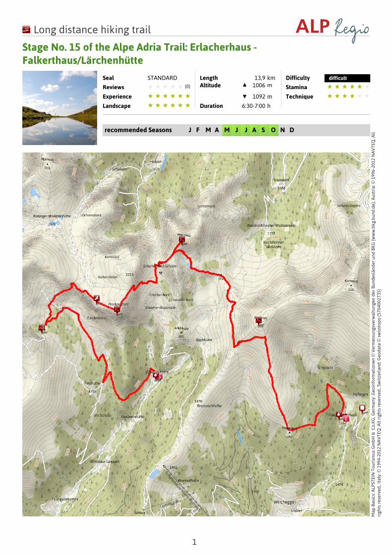
Stage No. 15 of the Alpe Adria Trail: Erlacherhaus -Falkerthaus/Lärchenhütte
1
Seal STANDARD
Reviews (0)
Experience
Landscape
Length 13,9 kmAltitude 1006 m
1092 m
Duration 6:30-7:00 h
Difficulty difficult
Stamina
Technique
recommended Seasons J F M A M J J A S O N D
Map
Bas
ics:
ALP
STEI
N T
ouri
smus
Gm
bH &
Co.
KG
, Ger
man
y: G
eoin
form
atio
nen
© V
erm
essu
ngsv
erw
altu
ngen
der
Bun
desl
ände
r un
d B
KG
(ww
w.b
kg.b
und.
de),
Aus
tria
: © 1
996-
2012
NA
VTE
Q. A
llri
ghts
res
erve
d., I
taly
: © 1
994-
2012
NA
VTE
Q. A
ll r
ight
s re
serv
ed.,
Swit
zerl
and:
Geo
data
© s
wis
stop
o (5
7040
0273
5)

Long distance hiking trail
Stage No. 15 of the Alpe Adria Trail: Erlacherhaus -Falkerthaus/Lärchenhütte
2
Description
SummaryThe variety of scented and flowering species on thisstage, through one of the most beautiful regions inthe Nockberge National Park, is the result of thealternating calciferous and crystalline primaryrocks. Three summits have to be conquered beforeyou reach the destination of this stage, theFalkerthaus; they are the Predigerstuhl (2,170metres), the Pfannock (2,254 metres) and theMallnock (2,226 metres).
DescriptionThis hike starts by leading westwards via a road foraround 30 minutes until just before the Feldhüttelodge. At the road junction you will come to hikingtrail 171 which runs northwards, and initially youwill walk along the south of the Zunderwand rockface until you are below the Törlwand. Finally youwill hike through a field of dwarf pines to LakeNassbodensee. The geological structure is veryobvious here, as the rock is constantly changingbetween chalk and primary rock. From LakeNassbodensee the route continues in a northeasterly direction. Before the Törl (a gate in therock) you cross a very steep section of Alpinemeadow, and then on the Törl there is an open viewto the north. The trail then continues along a highplateau to the Predigerstuhl (2,170 metres), fromwhich you have a very good overview of theremainder of the tour. You now descend to the
remains of the iron mining industry on the ErlacherBockscharte, then hike via an ascent to thePfannock (2,254 metres), the highest point of thisstage. From the Pfannock you go downhill again,past the Pfannseen lakes in an easterly direction asfar as the Oswalder Bocksattel, across the Rote Burgto the Brunnachgatter, where you change to hikingtrail 161, which takes you up to the Mallnock (2,226metres). Once you have reached the summit youfollow the WW 1 hiking trail to the Oswaldeck andthen the hiking trail to the Falkerthaus. This tour isclassed as moderately difficult.
Starting point of the tourErlacherhaus (im Langalmtal in Kaning)
DirectionsOn our arrival we come through Kaning, a mountainfarming village at more than 1,000 metres above sealevel, which is thought to have been founded around1,000 years ago. We walk past several Alpine farmsalong the Langalm Valley to our starting point. Fromthe Erlacherhaus the tour first takes us along anAlpine meadows access road until shortly before theFeldhütte lodge, where we change to hiking routenumber 171 in a northerly direction and thencontinue to hike to the Zunderwand by LakeNassbodensee.
The geology in this region is a special feature,because the calciferous rock alternates with thecrystalline primary rock, and this in turn is thedetermining factor for the wide variety of species of
Long distance hiking trail
Stage No. 15 of the Alpe Adria Trail: Erlacherhaus -Falkerthaus/Lärchenhütte
3
flowers and herbs. On the ascent from the forestarea we come to the open Alpine meadows andcatch sight of the imposing Zunderwand rock face,from which the summit cross of the Predigerstuhlshines down. Our ascent leads us on to the foot ofthe Zunderwand, where we change to hiking trailnumber 13 which runs through a field of dwarf pinesto Lake Nassbodensee. From Lake Nassbodensee wecontinue across the Törl and up to the Predigerstuhlat 2,170 metres above sea level. From there weenjoy a wonderful view of the Nockberge Mountainsas far as the Carnic and Julian Alps, as well as to theglacier of the Hochalmspitze. We also have a verynice view of the Erlacher Bockscharte, where thetraces of the former mining industry can still be seenclearly. We continue across the ErlacherBockscharte (from here we can take a small detourand stop for a rest at the Erlacher Bockhüttemountain lodge) via hiking trail number 14 onto thePfannock (2,254 metres), which is the highest pointof this stage. On the summit of the Pfannock we canalready see to the Mallnock and to the Pfannseenlakes at the foot of the Pfannock. We continue pastthe Pfannseen lakes to the Rote Burg on hiking trailNo. 161 to the Brunnachgatter. After a short ascentwe reach the last peak of this stage, the Mallnock(2,226 metres). From here we can once again enjoythe beautiful panorama of the NockbergeMountains before we head via the Oswaldeck to theFalkerthaus.
Editoral AdviceSehr empfehlenswerte Tour mit wunderbarenAussichtspunkten.
EquipmentFestes Schuhwerk, ev. kleine Jause sowie Getränkesollten nicht fehlen. Da die Tour zum Teil auf Gipfel,durch Grate und ausgesetzte Stellen führt,empfehlen wir, auf den Windschutz auch beiwarmen Temperaturen nicht zu verzichten.
Safety informationAuf allen Wanderwegstehern im BiosphärenparkNockberge finden Sie Aufkleber, die den genauenStandort mit den Koordinaten beschreiben. Sollte es
einen Notfall geben, folgen Sie bitte dieserAnleitung!
Getting thereVon Radenthein über Kaning durch das Langalmtalbis zum Erlacherhaus.
ParkingParkplatz beim Erlacherhaus.
Public transportAnfahrt mit dem Almexpress von Döbriach überRadenthein aus möglich - Fahrzeiten unbedingtbeachten, da dieser nicht täglich fährt!
Weitere Möglichkeit: der BergThermenBus.
Further information/linksBad Kleinkirchheimer Tourismus Marketing GmbHDorfstraße 309546 Bad KleinkirchheimTel.: +43 4240 8212Fax: +43 4240 [email protected]
End point of the tourFalkerthaus, Lärchenhütte, St. Oswald
Properties
Stage tour Nice viewsGipfel-Tour With refreshment
stops
Points of Interest
Tipp
Kirchleitn Kleinwild
Rosennockstraße 13
9546 Bad Kleinkirchheim
+43 (0) 4240-8244 www.kirchleitn.com
Tipp
Wanderhotel RestaurantBerghofRosennockstraße 55
9546 Bad Kleinkirchheim
04240/479 www.berg-hof.at
Tipp
Hotel Kärntnerhof****
Maibrunnenweg 15
9546 Bad Kleinkirchheim
+43 4240 293 www.hotelkaerntnerhof.com

Long distance hiking trail
Stage No. 15 of the Alpe Adria Trail: Erlacherhaus -Falkerthaus/Lärchenhütte
4
Tipp
Pension Isabella***
Tiefenbachstraße 8
9546 Bad Kleinkirchheim
+ 43 4240 333 www.pensionisabella.at
Tipp
Hotel Trattlerhof****
Gegentalerweg 1
9546 Bad Kleinkirchheim
+43 4240 8172 www.trattlerhof.at
Tipp
Thermenwelt Pulverer*****
Thermenstraße 4
9546 Bad Kleinkirchheim
+43 4240 744 www.pulverer.at
Tipp
Buschenschank Streitnighof
Bernsteinweg 7
9546 Bad Kleinkirchheim
04240/8416
Tipp
Thermenhotel Ronacher
Thermenstraße 3
9546 Bad Kleinkirchheim
+43 4240 282 www.ronacher.com
Tipp
Lärchenhütte
Falkertweg 30
9546 Bad Kleinkirchheim
0664/5682666www.urlaubaufderalm.com/Laerchenhuette.htm
Predigerstuhl
Naßbodensee
Großer Rosennock
Mallnock Gipfelkreuz
Erlacher Haus
Kaning 68
9545 Radenthein
0043 (0)4246-4460
Falkerthaus
Falkertweg 33
9546 Bad Kleinkirchheim
06765724090
Author and source
Author Alexandra Rieger
created 01.03.2011
changed 15.03.2013
Source Kärnten Werbung GmbH -AlpeAdriaTrail
Pictures
NaßbodenseeAuthor Bad Kleinkirchheimer Tourismus Marketing GmbH
Source Bad Kleinkirchheim Tourismus
PfannseeAuthor Bad Kleinkirchheimer Tourismus Marketing GmbH
Source Bad Kleinkirchheim Tourismus

Long distance hiking trail
Stage No. 15 of the Alpe Adria Trail: Erlacherhaus -Falkerthaus/Lärchenhütte
5
Blick vom Nassbodensee zur ZunderwandAuthor Biosphärenparkverwaltung Nockberge / Mayer
Source Kärnten Werbung GmbH - AlpeAdriaTrail
MallnockAuthor Nationalparkverwaltung Nockberge / Maierbrugger
Source Bad Kleinkirchheim Tourismus
FalkerthausSource Bad Kleinkirchheim Tourismus
Biosphärenpark Nockberge
Author Alexandra Rieger
Source Kärnten Werbung GmbH - AlpeAdriaTrail
Gr. Rosennock und Kl. RosennockAuthor Nationalparkverwaltung Nockberge / Mayer
Source Bad Kleinkirchheim Tourismus