Embed Size (px)
Citation preview
Lemko Place, Penrith NSW 2750 PO Box 880, Penrith NSW 2751
Telephone (02) 4722 2700 Facsimile (02) 4722 2777 e-mail: [email protected] www.geotech.com.au
®
ABN 64 002 841 063
EOTECHNIQUE G PTY LTD
PRELIMINARY CONTAMINATION ASSESSMENT
LOT 1 IN DP30211 14 CLARK STREET, RIVERSTONE
REPORT NO 13942/1-AA 15 FEBRUARY 2017
Lemko Place, Penrith NSW 2750 PO Box 880, Penrith NSW 2751
Telephone (02) 4722 2700 Facsimile (02) 4722 2777 e-mail: [email protected] www.geotech.com.au
®
ABN 64 002 841 063
EOTECHNIQUE G PTY LTD
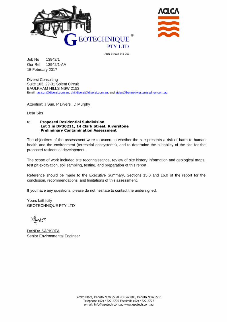
Job No 13942/1
Our Ref: 13942/1-AA
15 February 2017
Diversi Consulting Suite 103, 29-31 Solent Circuit BAULKHAM HILLS NSW 2153 Email: [email protected], [email protected], and [email protected]
Attention: J Sun, P Diversi, D Murphy Dear Sirs re: Proposed Residential Subdivision
Lot 1 in DP30211, 14 Clark Street, Riverstone Preliminary Contamination Assessment
The objectives of the assessment were to ascertain whether the site presents a risk of harm to human
health and the environment (terrestrial ecosystems), and to determine the suitability of the site for the
proposed residential development.
The scope of work included site reconnaissance, review of site history information and geological maps,
test pit excavation, soil sampling, testing, and preparation of this report.
Reference should be made to the Executive Summary, Sections 15.0 and 16.0 of the report for the
conclusion, recommendations, and limitations of this assessment.
If you have any questions, please do not hesitate to contact the undersigned.
Yours faithfully
GEOTECHNIQUE PTY LTD
DANDA SAPKOTA
Senior Environmental Engineer
Lemko Place, Penrith NSW 2750 PO Box 880, Penrith NSW 2751
Telephone (02) 4722 2700 Facsimile (02) 4722 2777 e-mail: [email protected] www.geotech.com.au
®
ABN 64 002 841 063
EOTECHNIQUE G PTY LTD
EXECUTIVE SUMMARY
This executive summary presents a synopsis of a preliminary contamination assessment (PCA) for a
parcel of land currently registered as Lot 1 in DP30211, located at 14 Clarke Street, Riverstone, in the
local government area of Blacktown.
It is understood that the site covers an area of about 10.4 hectares (ha), and that the site is proposed for
a residential subdivision development.
The objectives of the assessment were to ascertain whether the site presents a risk of harm to human
health and the environment (terrestrial ecosystems), and to determine the suitability of the site for the
proposed residential subdivision development.
The scope of work included site reconnaissance, review of site history information and geological maps,
test pit excavation, soil sampling, testing, and preparation of this report.
The findings of this PCA are summarised as follows:
The site contained various site features, as shown on Drawing No 13942/1-AA1 and the Site
Photographs (Appendix E).
The general sub-surface profiles at the test pit / sample locations and soil profile in stockpiles were
as follows:
Fill (thickness ranging from 150mm to 400mm), comprising silty clay, medium plasticity, brown
with gravel, underlain by natural soil in test pit locations TP1 to TP3. Only surface samples (0-
0.15m) were recovered within test pits TP1 and TP2 due to access limitations.
Topsoil (thickness ranging 200 to 600mm) comprising, gravelly silt, low plasticity, with inclusion
of shale fragments, underlain by natural soil at TP4 to TP120. Topsoil with thickness of 600mm
was encountered in TP20 to TP24. Topsoil, comprising, silty Clay, low to medium plasticity,
brown, with gravel was also observed at locations C1 to C3 in the vicinity of abandoned car
locations.
Fibro-cement pieces (FCP) and potentially asbestos containing material (ACM) were observed
at isolated locations, and representative samples of FCP were collected for analysis of asbestos
from locations FCP1, FCP2, FCP3, FCP4, FCP5 (in the plastic bag), FCP6 & FCP7
(Stockpile 10) and FCP8 (TP2 0-0.15m).
Stockpile comprising, silty sands, fine grained grey,, silty clay, low to medium plasticity, brown
with gravel with or without building debris, concrete and terracotta fragments, were encountered
within the stockpile locations SP1 to SP11.
Based on the test results presented in the summary tables (Tables D to L) and discussed in Section
13.2, the majority of the laboratory test results satisfied the criteria for stating that the analytes
selected are either not present i.e. concentrations less than laboratory limits of reporting (LOR), or
present in the sampled soil at concentrations that do not pose a risk of harm to human health or the
environment (terrestrial ecosystems) under a “residential with access to soil” form of development,
with the exception of elevated concentration of zinc (Zn) in SP6, the presence of fibrous
asbestos/asbestos fines (FA/AF) within TP2 (0-0.15m) and SP10-1 (0-0.15m), and presence of ACM
at FCP1, FCP2-1, FCP3, FCP4, FCP5, FCP6 FCP7 (Stockpile 10), FCP8 (TP2 0-0.15m) and SP3
(0-0.15m).
ii
13862/1-AA Executive Summary continued
Diversi Consulting
DS.mh/15.02.2017
G EOTECHNIQUE PTY LTD
The elevated concentration of Zn might present a risk of harm to the environment (terrestrial ecosystems). The presence of FA/AF will present a risk of harm to human health. The presence of ACM would potentially present a risk of harm to human health. Based on this PCA, the site is considered environmentally suitable for the proposed residential
development subject to following:
Detailed assessment of ACM (>7mm) and FA (<7mm) impacted soils as indicated on Drawing No
13942/1-AA3, to determine the extent of asbestos contamination within the site, and asbestos
clearance of the site by Safe Work licensed asbestos assessor.
Detailed assessment to determine the extent of Zn contamination at the identified location of concern
indicated on Drawing No 13942/1-AA3.
Assessment of soils in the footprints of existing site features after complete demolition and/or
removal by licensed contractor. The purpose of this is to ascertain the presence or otherwise of
“suspect” materials (identified by unusual staining, odour, discolouration or inclusions such as
building rubble, asbestos, ash particles, etc.) and fill.
Sampling and testing will be required to determine the contamination status of soils in the footprints
of site features. The type of testing on samples recovered from the footprints will depend on the
materials (topsoil, natural soil, suspect materials or fill) encountered. In the event of contamination,
detailed assessment, remediation and validation will be required.
Development of a remedial action plan (RAP) for the remediation of asbestos, Zn impacted soils, and
any other contamination identified through the detailed, additional sampling and testing beneath the
site features, followed by appropriate validation.
Assessment of the dam water prior to dewatering, to determine the contamination status of the water
and recommend dewatering method.
On completion of dewatering, contamination assessment of the dam sediment and dam walls should
be carried out.
It should be noted that since part of the site was used in the past and currently being used for agricultural
activities, there is a potential for buried irrigation pipes to remain beneath the ground surface. If any
asbestos pipes are uncovered, a qualified asbestos removal contractor must be engaged to carry out
removal. Asbestos clearance will be required after removal.
If any suspect materials (identified by unusual staining, odour, discolouration or inclusions such as
building rubble, asbestos sheets/pieces/pipes, ash material, etc.) are encountered during any stage of
future earthworks/site preparation/demolition/remediation, in areas other than mentioned above or
between the sampling locations or any areas masked by overgrown grass present within the site, the
Unexpected Finds Management Protocol (Appendix F) should be implemented. In the event of
contamination, detailed assessment, remediation and validation will be necessary.
For any materials to be excavated and removed from the site, it is recommended that waste classification
of the materials is undertaken, in accordance with the "Waste Classification Guidelines Part 1: Classifying
Waste"( NSW EPA 2014), NSW EPA resource recovery exemptions and orders under the Protection of
the Environment Operations (Waste) Regulation 2014, or NSW EPA Certification: Virgin excavated
natural material, prior to disposal at an appropriately licensed landfill or potential re-use at other sites.

iii
13862/1-AA Executive Summary continued
Diversi Consulting
DS.mh/15.02.2017
G EOTECHNIQUE PTY LTD
Any imported fill must be assessed by a qualified environmental consultant, prior to importation, to ensure
suitability for the proposed use. In addition, the imported fill must be free from asbestos, ash and odour,
not be discoloured and not acid sulphate soil. The imported fill should either be virgin excavated natural
material (VENM) or excavated natural material (ENM). Reference should be made to Section 16.0 of the
report and Appendix G, which set out details of the limitations of the assessment.
Diversi Consulting DS.mh/15.02.2017
G EOTECHNIQUE PTY LTD
TABLE OF CONTENTS
Page
1.0 INTRODUCTION----------------------------------------------------------------------------------------- 1
2.0 SCOPE OF WORK --------------------------------------------------------------------------------------- 2
3.0 SITE IDENTIFICATION --------------------------------------------------------------------------------- 2
4.0 SITE HISTORY ------------------------------------------------------------------------------------------ 3
4.1 Aerial Photographs ----------------------------------------------------------------------- 3
4.2 NSW EPA Notices ------------------------------------------------------------------------- 3
5.0 SITE CONDITON AND SURROUNDING ENVIRONMENT ----------------------------------------------- 3
5.1 Site Condition ---------------------------------------------------------------------------- 3
5.2 Surrounding Environment --------------------------------------------------------------- 6
6.0 TOPOGRAPHY, GEOLOGY & HYDROGEOLOGY--------------------------------------------------------- 6
7.0 CONCEPTUAL SITE MODEL ---------------------------------------------------------------------------- 7
7.1 Potential Areas of Environmental Concern ---------------------------------------------- 7
7.2 Potentially Contaminated Media --------------------------------------------------------- 8
7.3 Potential Migration ----------------------------------------------------------------------- 8
8.0 SAMPLING & ANALYSIS PLAN AND SAMPLING METHODOLOGY ------------------------------------- 9
9.0 FIELD QUALITY ASSURANCE AND QUALITY CONTROL --------------------------------------------- 12
9.1 Sampling Personnel -------------------------------------------------------------------- 12
9.2 Decontamination Procedures ---------------------------------------------------------- 12
9.3 Rinsate Samples ----------------------------------------------------------------------- 13
9.4 Duplicate Samples --------------------------------------------------------------------- 13
9.5 Inter-laboratory Duplicate (Split) Sample ---------------------------------------------- 14
10.0 LABORATORY QUALITY ASSESSMENT AND QUALITY CONTROL ---------------------------------- 14
11.0 QA/QC DATA EVALUATION-------------------------------------------------------------------------- 15
12.0 ASSESSMENT CRITERIA ---------------------------------------------------------------------------- 16
13.0 FIELD & LABORATORY TEST RESULTS, ASSESSMENT & DISCUSSION --------------------------- 17
13.1 Field Results ---------------------------------------------------------------------------- 17
13.2 Analytical Results – Soil Samples ----------------------------------------------------- 17
13.2.1 Metals (As, Cd, Cr, Cu, Pb, Hg, Ni & Zn), pH and CEC .................................................... 17 13.2.2 TRH and BTEX ............................................................................................................... 18 13.2.3 Polycyclic Aromatic Hydrocarbons (PAH) ........................................................................ 18 13.2.4 Organochlorine Pesticides (OCP) and PCB ..................................................................... 18 13.2.5 Asbestos ......................................................................................................................... 18
14.0 SITE CHARACTERISATION -------------------------------------------------------------------------- 19
15.0 CONCLUSION AND RECOMMENDATIONS ---------------------------------------------------------- 19
16.0 LIMITATIONS ---------------------------------------------------------------------------------------- 21
ii
13942/1-AA Table of Contents continued
Diversi Consulting DS.mh/15.02.2017
G EOTECHNIQUE PTY LTD
LIST OF REFERENCES
DRAWINGS
Drawing No 13942/1-AA1 Site Features
Drawing No 13942/1-AA2 Test Pit Locations
Drawing No 13942/1-AA3 Locations/Areas of Concern
TABLES
Table A Rinsate Samples
Tables B1 and B3 Duplicate Samples
Tables C1 and C3 Split Samples
Tables D Metals, Cation Exchange Capacity (CEC) & pH Test Results - Discrete
Samples
Tables E CEC & pH Test Results - Discrete Samples
Tables F Metals Test Results - Composited Samples
Tables G1 Copper Test Results – Sub-Samples
Tables G2 Zinc Test Results – Sub-Samples
Tables H Total Recoverable Hydrocarbons (TRH) and BTEX Test Results – Discrete
Samples
Table I Polycyclic Aromatic Hydrocarbons (PAH) Test Results – Discrete Samples
Table J Organochlorine Pesticides (OCP), Polychlorinated Biphenyls (PCB) Test
Results - Discrete Samples
Table K Organochlorine Pesticides (OCP) Test Results - Composited Samples
Table L Asbestos Test Results – Discrete Samples
APPENDICES
APPENDIX A Cadastral Plan
APPENDIX B Aerial Photos
APPENDIX C NSW OEH Records of EPA Notices
APPENDIX D Test Pit Logs
APPENDIX E Site Photographs
APPENDIX F Unexpected Finds Management Protocol
APPENDIX G Environmental Notes
1
13942/1-AA
Lot 1 in DP30211 -14 Clarke Street, Riverstone
Diversi Consulting DS.mh/15.02.2017
G EOTECHNIQUE PTY LTD
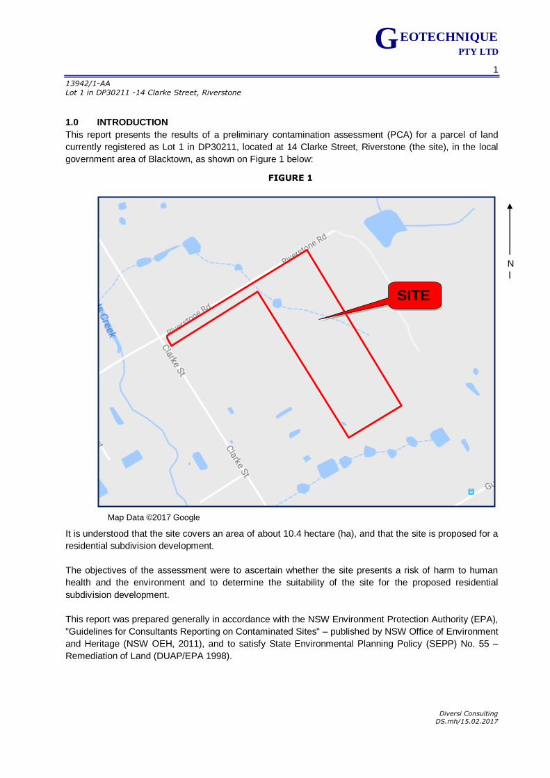
1.0 INTRODUCTION
This report presents the results of a preliminary contamination assessment (PCA) for a parcel of land
currently registered as Lot 1 in DP30211, located at 14 Clarke Street, Riverstone (the site), in the local
government area of Blacktown, as shown on Figure 1 below:
It is understood that the site covers an area of about 10.4 hectare (ha), and that the site is proposed for a
residential subdivision development.
The objectives of the assessment were to ascertain whether the site presents a risk of harm to human
health and the environment and to determine the suitability of the site for the proposed residential
subdivision development.
This report was prepared generally in accordance with the NSW Environment Protection Authority (EPA),
"Guidelines for Consultants Reporting on Contaminated Sites" – published by NSW Office of Environment
and Heritage (NSW OEH, 2011), and to satisfy State Environmental Planning Policy (SEPP) No. 55 –
Remediation of Land (DUAP/EPA 1998).
FIGURE 1
N
Map Data ©2017 Google
SITE
2
13942/1-AA
Lot 1 in DP30211 -14 Clarke Street, Riverstone
Diversi Consulting DS.mh/15.02.2017
G EOTECHNIQUE PTY LTD
2.0 SCOPE OF WORK
In order to achieve the objectives of this assessment, the following scope of work was conducted in
accordance with our fee proposal (Q7930 dated 10 January 2017) and the variation emailed on 15
January, 2017:
A desktop study of the following to assist in identification of potential contamination issues:
Historical aerial photographs.
NSW EPA Notices.
Soils and geological maps.
Inspection by a Field Engineer from Geotechnique Pty Ltd (Geotechnique) to identify current site
activities, site features, and any visible or olfactory indicators of potential contamination.
Prior to sampling, the locations were scanned in order to avoid any underground services. In order to
minimise the cost of testing, most of the samples were composited for non-volatile analysis. Each
composite sample was formed from three discrete samples.
Soil sampling by the Field Engineer in accordance with a pre-determined sampling plan, developed
with reference to the NSW EPA Sampling Design Guidelines, and aimed at ascertaining the
presence or otherwise of soil contaminants in the open accessible area of the site.
Recovery of soil samples from one hundred and twenty (120) test pit locations using a backhoe and
mattock (in inaccessible areas to backhoe) from open accessible areas, and recovery of additional
samples from the soil stockpiles within the site, followed by appropriate chemical analysis.
It should be noted that assessment of soil beneath the site features (as indicated on Drawing No
13942/1-AA1 and Site photographs in Appendix E) the will be required after demolition, but prior to
earthworks.
Chemical analysis by National Association of Testing Authorities (NATA) accredited testing
laboratories, in accordance with chain of custody (COC) prepared by Geotechnique.
Implementation of industry standard quality assurance (QA) and quality control (QC) measures. QC
samples were also forwarded to the testing laboratories.
Assessment of the laboratory analytical results against current applicable guidelines.
Assessment of field and laboratory QA and QC.
Preparation of this report.
3.0 SITE IDENTIFICATION
The site is located at located at 14 Clarke Street and is registered as Lot 1 in DP30211. The site covers an area of 10.4ha.
Reference may be made to the deposited and cadastral plans in Appendix A for the Lot and the deposited
plan (DP) details.
3
13942/1-AA
Lot 1 in DP30211 -14 Clarke Street, Riverstone
Diversi Consulting DS.mh/15.02.2017
G EOTECHNIQUE PTY LTD
4.0 SITE HISTORY
In order to formulate a picture of the site history and to assist in identification of any potential
contamination, Geotechnique obtained and/or reviewed information including historical aerial
photographs, and NSW EPA notices for contaminated land, published by NSW OEH. The information
reviewed is presented in the following sub-sections.
4.1 Aerial Photographs
Aerial photographs taken in 1961, 1970, 1975, 1998, 2005 and 2016 were examined. Copies of the aerial
photographs are attached.
1961 The site and the adjoining properties to the east, appear to be part of a larger
parcel of rural land, appear vacant and covered with grass and trees (along the
western boundary of the site). The adjoining property to the west is part of the
rural land.
1970, 1975 and 1998 Buildings/sheds associated with rural residential are noted in the middle portion
of the site. The adjoining properties are rural residential with buildings and
sheds and/or with market garden activities.
2005 and 2016 The trees in the middle portion of the site have been partially cleared, and the
adjoining properties appear to remain essentially rural land with market
gardens activities.
4.2 NSW EPA Notices
NSW OEH maintains the record of EPA notices regarding the contaminated sites under Section 58 of the
Contaminated Land Management (CLM) Act 1997. The notices relate to investigation and/or remediation
of site contamination considered to pose a significant risk of harm under the definition in the CLM Act
1997.
A search of the EPA Notices on 13 February 2017 (Appendix C) revealed no EPA notices issued for the
site.
It should be noted that the record of EPA notices for Contaminated Land does not provide a record of all
contaminated land in NSW. At the time of searching the records, 349 sites in NSW were registered in the
data base.
The EPA issues environment protection licences to owners or operators of various industrial premises
under the Protection of the Environment Operations (POEO) Act to control the air, noise, water and waste
impacts of an activity.
A search of the POEO Public Register 13 February 2017 found no records for the site (Appendix C).
5.0 SITE CONDITON AND SURROUNDING ENVIRONMENT
5.1 Site Condition
For ease of reference, the site is divided into two parts, the north western portion of the site, and the
eastern portion of the site. The north western part of the site is small rectangular in shape, and has
access from Clarke Street. The eastern part, representing a larger rectangle is accessed via Riverstone
Road.
4
13942/1-AA
Lot 1 in DP30211 -14 Clarke Street, Riverstone
Diversi Consulting DS.mh/15.02.2017
G EOTECHNIQUE PTY LTD
The closest creek is approximately 145m to the east.
There is also a dam with water in the north eastern portion of the site, with the flow of water following a
path from the adjoining property in the north.
North Western portion of the site:
The site slopes down gently (0° to 10
°) from the north east to the south west. The north eastern part of the
property the slope declines from the south west direction to the north east.
The following site features were observed within the site by the Environmental during the site inspection
and field sampling:
Vegetable garden.
A fibro house with potentially asbestos containing material (ACM).
Scrap metals, truck/excavator, and long grass.
Timber, plastic, and long grass.
Timber, plastic, scrap metal, metal sheds, ceramics, car trailers, and long grass.
Scrap metals and timber.
Asbestos pieces in black plastic bag.
Wooden crates.
Two abandoned cars.
Tyres and metal fence.
Stockpile 11 - 5m x 3.9m x 0.2m (average height).
Eastern portion of the site:
The ground is undulating (please refer to attached drawing 13942/1-AA1). The general slope is from
northwest to southeast towards the rear of the property, and from the southeast to northwest from the
horse paddock areas. Scattered pieces of Asbestos were found in the northeast and towards the
southeast.
Scattered rubbish, including scrap metals, plastics, brick pieces, tyres and concrete pieces were
observed in various places throughout the site. Towards the centre of the site, there is an area which has
been utilised for training horses. To the east of this training field is an area where there are tyres, scrap
metals, car trailers, plastic water containers, tiles, caravans, and timber pieces. Small stockpiles with
scattered scrap metals, brick pieces and concrete pieces were found in close proximity. To the west of
the horse training ground, there is another area where scattered rubbish was found, including plastic
chairs, tyres, scrap metals, bricks, burnt items, scattered asbestos pieces, and wooden pieces. There
were moderately dense trees at the front and rear of the property. Dirt tracks were observed in the
northwest of the property, which were utilised by various vehicles.
5
13942/1-AA
Lot 1 in DP30211 -14 Clarke Street, Riverstone
Diversi Consulting DS.mh/15.02.2017
G EOTECHNIQUE PTY LTD
The following locations/areas were observed:
Areas with scattered ACM.
Scattered plastic, and scrap metals.
Scattered rubbish, tyres, and scrap metals.
Metal shed.
Dam with water.
Area with concrete, bricks, tyres, plastics and scrap metals.
Stockpile 10 - 27.5m x5m x 0.6m (average height).
Stockpile 9 - 1250m2 with 1m (average height).
Stockpile 8 - 5m x5m x 1m (average height).
Stockpile 7 - 9 x 4. 5m x 0.5m (average height).
Stockpile 6 - 2 x 4m x 0.2m (average height).
Stockpile 5 - 20 x 3m x 0.2m (average height).
Stockpile 4 - 10.5 x 5m x 0.2m (average height).
Stockpile 3 - 4 x3.5m x 0.3m (average height).
Stockpile 2 - 13.5 x 4m x 0.2m (average height).
Stockpile 1 - 3.5 x 4m x 0.5m (average height).
Horse paddock.
3 Metal sheds.
Area with plastic chairs, tyres, scrap metals, brick bunts items, scattered asbestos pieces, wooden
pieces (timber).
Area with scrap metals, trailers, abandoned cars, Plastic, water containers, tiles caravan, and
wooden pieces.
Area with tyres.
Plastic, chairs, tyres, scrap metals, brick, burnt items, scattered asbestos pieces and wooden pieces.
There were no other obvious features associated with any underground storage tanks (bowser,
breather pipe, inlet valve and piping) or odour that would indicate the potential for contamination.
There were no visible or olfactory indicators of potential contamination.
It must be noted that the stockpiles dimensions (for Stockpiles 1 to 11) are indicative only. The
actual volume of the stockpiles should determined by registered surveyors.
Reference can be made to Drawing No 13942/1-AA1 for the details of the site features observed in the
north western and eastern portion of the site.
6
13942/1-AA
Lot 1 in DP30211 -14 Clarke Street, Riverstone
Diversi Consulting DS.mh/15.02.2017
G EOTECHNIQUE PTY LTD
5.2 Surrounding Environment
At the time of inspection, the neighbouring properties were rural residential, with or without market garden
activities.
6.0 TOPOGRAPHY, GEOLOGY & HYDROGEOLOGY
The site slopes down gently (0° to 10°) from the northeast to the southwest. In the north east of the
property, the slope declines from the south west to the north east.
In the north eastern portion of the site, the ground is undulating (please refer to attached drawing
13942/1-AA1). In the rear of the property, the site slopes down from northwest to southeast, and from the
southeast to northwest in the horse paddock areas.
Reference to the Geological Map of Penrith (Clark and Jones 1991) indicates that the bedrock at the site
is Bringelly Shale, belonging to the Wianamatta Group of rocks and comprising shale, carbonaceous
claystone, laminite, fine to medium grained lithic sandstone and rare coal, and in the proximity of Ashfield
Shale with dark grey to black claystone-siltstone and fine sandstone-siltstone laminite.
Reference to the Soil Landscape Map (Hazelton et al. 1989) of Penrith indicates that the landscape at the
site belongs to the Blacktown Group, which is characterised by gently undulating rises on Wianamatta
Group shales, with local relief to 30m, ground slopes less than 5 percent, broad rounded crests and
gently inclined slopes. The sub-surface soil in this landscape is likely to be up to 3.0m thick, moderately
reactive, highly plastic, and with poor drainage.
Reference should be made to Test Pit Logs in Appendix D for descriptions of the soils encountered during
sampling for this assessment. Based on information from the test pits, the soil profile across the site is
generalised as follows:
Topsoil Gravelly silt, low plasticity, with inclusion of shale fragments, thickness ranging
200 to 600mm, underlain by natural soil at TP4 to TP120. Topsoil, comprising,
silty Clay, low to medium plasticity, brown, with gravel was also observed at
locations C1 to C3 in the vicinity of abandoned car locations.
Topsoil with thickness of 600mm was encountered in TP20 to TP24.
Fill Silty clay, medium plasticity, brown with gravel, thickness ranging from 150mm
to 400mm, underlain by natural soil within the test pit locations, TP1 to TP3.
Only surface samples were recovered from TP1 and TP2 (0-0.15m) due to
access limitations. Full depth of the fill to be determined at later stage.
Natural Soil Silty CLAY, medium plasticity, brown.
Fibro-cement pieces (FCP) and potentially ACM were observed at isolated locations, and representative
samples of FCP were collected for analysis of asbestos from locations FCP1, FCP2, FCP3, FCP4, FCP5
(in the plastic bag), FCP6 and FCP7 (Stockpile 10), and FCP8 (TP2 0-0.15m). The photographs taken
during the field sampling are also presented in Appendix E.
7
13942/1-AA
Lot 1 in DP30211 -14 Clarke Street, Riverstone
Diversi Consulting DS.mh/15.02.2017
G EOTECHNIQUE PTY LTD
Stockpile comprising, silty sands, fine grained grey, silty clay, low to medium plasticity, brown with gravel
with or without building debris, concrete and terracotta fragments, were encountered within the stockpile
locations SP1 to SP11.
A site-specific groundwater assessment was beyond the scope of this study.
7.0 CONCEPTUAL SITE MODEL
7.1 Potential Areas of Environmental Concern
Based on the preceding sections, areas of environmental concern (AEC) and associated contaminants of
potential concern have been identified and are presented in the following table:
Areas of Environmental Concern& Associated Contaminants of Potential Concern
AEC Rationale / Details Potential Contaminants of Concern3
In the vicinity of the existing
site features such fibro-
house and metal sheds
Fibro house may contain asbestos.
There is potential for metal and OCP
contamination in the surface soils
surrounding the house and sheds due to
possible pest control.
Metals1, Organochlorine Pesticides
(OCP) and asbestos
Potential fill beneath the site
features. Site Feature
(including houses, driveways
and sheds, etc
Potential for filling to have taken place
for levelling the site surface, and fill
materials could have been generated or
imported from unknown sources.
Therefore there is potential for the fill
materials to be contaminated.
Metals 1, Total Recoverable
Hydrocarbons (TPH), Benzene,
Toluene, Ethylbenzene, Xylenes
(BTEX), Polycyclic Aromatic
Hydrocarbon (PAH), Organochlorine
Pesticides (OCP), Polychlorinated
Biphenyl (PCB) and asbestos2
Fibro-house and areas with
scattered asbestos
Fibro house may contain asbestos.
There is potential for asbestos
contamination in the surface soils
surrounding the house and sheds
Asbestos
Dam Potential contamination due to the
surface runoff to the dam.
Metals1, TPH, BTEX, PAH, OCP, and
PCB
Stockpiles (No 1 to 11) Soil stockpile could have been imported
or generated within the site.
Metals1, TPH, BTEX, PAH, OCP, PCB
and asbestos
Fill area
Potential for filling to have taken place
for levelling the site surface, and fill
materials could have been generated or
imported from unknown sources.
Therefore there is potential for the fill
materials to be contaminated.
Metals1, TPH, BTEX, PAH, OCP, PCB
and asbestos
Areas with scrap metal,
timber, caravan, car taileres,
abandoned vehicles,
Possible degradation of metal in the
surrounding areas
To be removed for aesthetic reasons
and footprints to be inspected
Scattered rubbish, plastic
and tyres
Possible degradation of metal in the
surrounding areas.
To be removed for aesthetic reasons
and footprints to be inspected
Timber and plastic in
overgrown grass areas Potential masking of contaminaion
To be removed for aesthetic reasons
and footprints to be inspected
Woden Crates Aesthetic issue To be removed for aesthetic reasons
and footprints to be inspected
Market garden area Potential use of pesticides. Metals1 and OCPOCP
1. Metals suite includes arsenic, cadmium, chromium, copper, lead, mercury, nickel and zinc. 2. Asbestos may present in fill materials with inclusions of demolition waste and / or fibro-cement pieces.
3. The suite of potential contaminants identified in the above table should be reviewed subject to the findings of inspection of the footprints after removal of site features.
8
13942/1-AA
Lot 1 in DP30211 -14 Clarke Street, Riverstone
Diversi Consulting DS.mh/15.02.2017
G EOTECHNIQUE PTY LTD
7.2 Potentially Contaminated Media
Potentially contaminated media present at the site includes topsoil, fill material, and natural soils.
Based on the potential mobility of contaminants and their associated potential leachability through the soil
/ fill profile, vertical migration of contaminants from the surface soils and fill material into the underlying
natural soils might have occurred. As a result, the natural soils are also considered to be potentially
contaminated media.
Given the relatively impermeable nature of the natural residual soil beneath the site, groundwater
underlying the site is considered to have a low potential to be impacted. However, if a substantial source
is identified within the soil on-site, a groundwater assessment could be necessary.
7.3 Potential Migration
Contaminants generally migrate from a site via a combination of windblown dust, rainwater infiltration,
groundwater migration, and surface water run-off. The potential for contaminants to migrate is a
combination of:
The nature of the contaminants (solid / liquid and mobility characteristics).
The extent of the contaminants (isolated or widespread).
The location of the contaminants (surface soils or at depth).
The site topography, geology, hydrology and hydrogeology.
Off-site impacts of contaminants in soil are generally governed by the transport media available and likely
receptors. The most common transport medium is water, whilst receptors include initially uncontaminated
soils, groundwater, surface waterbodies, humans, flora and fauna.
The potential contaminants identified as part of the site history review, site inspection and field sampling
were generally in a solid form (e.g. metals, OCP, PAH and asbestos, etc.).
The site is grass and tree covered or sealed by hard stand (house and sheds) across the site surface.
The potential for migration of contaminants via wind-blown dust is considered low as a result of the
exposed soils within the site. The potential for migration of contamination via surface run-off is also
expected to be minor. Some migration of contaminants via surface water may still occur in the event of
heavy rain. Surface run-off would generally follow the topography and partly eventuate in the dam within
the site.
Migration of soil contaminants to the deeper soils or groundwater regime would generally be via leaching
of contaminants from the surface soil or fill, facilitated by infiltration of surface water. Given that the
naturally occurring soils beneath the site are relatively impermeable (refer to Section 6.0 for the regional
geology information), the potential for recent and ongoing migration of contaminants from the site to the
groundwater table below is considered low. Furthermore, the relatively impermeable clay would have
minimised the potential for contaminants in the past to migrate to deeper soils or the groundwater regime.
It is considered unlikely that the groundwater regime beneath the site has been impacted by
contaminants in the soils. If high levels and widespread contaminants are detected through this
assessment, a groundwater assessment will be recommended.
9
13942/1-AA
Lot 1 in DP30211 -14 Clarke Street, Riverstone
Diversi Consulting DS.mh/15.02.2017
G EOTECHNIQUE PTY LTD
Sensitive receptors at the site under the current site conditions and in the immediate vicinity are
considered to include site residents, visitors and workers within the site who may come into contact with
potentially contaminated media within the site.
8.0 SAMPLING & ANALYSIS PLAN AND SAMPLING METHODOLOGY
Sampling and analyses for the contamination assessment were carried out to obtain a reasonable
assessment of the following:
1. Nature, location, and likely distribution of soil contaminants beneath the site.
2. The risks that the contaminants (if present) pose to human health or the environment under the
conditions of the proposed development.
The risk of harm to human health and the environment was determined through comparison of test results
with NSW EPA produced or endorsed criteria available at the time.
Soil sampling was carried out between 30 January and 2 February 2017 by Geotechnical/Environmental
Engineers from Geotechnique, who were responsible for visually assessing the site, locating the
nominated sampling locations, recovery of soil samples, preparation of samples for delivery to NATA
accredited laboratories, and logging the sub-surface profile encountered at each sampling locations.
Based on the "Sampling Design Guidelines for Contaminated Sites" (NSW EPA 1995), one hundred and
twenty (120) systematic sampling locations (TP1 to TP120) were adopted across the subject site area for
residential development. Judgemental samples within the stockpiles and suspected areas in the vicinity
of abandoned vehicles were also recovered.
The test pit locations are shown on Drawing No 13942/1-AA2.
Based on the relatively impermeable nature of the residual soils beneath the site, it is considered that
there is only low potential for groundwater contamination beneath the site. As such, a groundwater
assessment was not initially included as part of the scope of work. If high levels of contaminants are
detected through this assessment, a recommendation will be made for a groundwater assessment.
Prior to excavation using a backhoe, all the sampling points were scanned to avoid any underground
services.
The sampling procedures adopted were as follows:
The sample location was excavated to a pre-determined depth. The representative soil sample was
recovered directly from the bulk bucket of the backhoe / mattock using a stainless steel trowel. The
trowel was decontaminated prior to use in order to prevent cross contamination. Refer to Section 9.2
for details of the procedures for decontamination of the trowel.
To minimise the potential loss of suspected volatiles, the laboratory soil sample was immediately
transferred to a labelled, laboratory supplied, 250ml glass jar and sealed with an airtight, Teflon
screw top lid. The fully filled jar was then placed in a chilled container.
The recovered soil sample for asbestos analysis was transferred into a small plastic bag, which was
placed in the chilled container.
Sample for asbestos analysis was placed into a small plastic bag, which was placed in the chilled
container.
10
13942/1-AA
Lot 1 in DP30211 -14 Clarke Street, Riverstone
Diversi Consulting DS.mh/15.02.2017
G EOTECHNIQUE PTY LTD
In order to ensure the analytical performance of the primary laboratory duplicate and split samples were
prepared for analyses. Samples were kept in a labelled, laboratory supplied, glass jar (acid-washed and
solvent-rinsed), and sealed with an airtight, screw top Teflon lid. The fully filled jar was placed in a chilled
container.
Four rinsate water samples (R1 to R4) were prepared and placed in a glass bottle supplied by the
laboratory. The fully filled bottles were labelled and placed in a chilled container. At completion of field
sampling, the chilled container was transported to our Penrith office and transferred to a refrigerator
where the temperature was maintained below 4°C.
The chilled containers were forwarded to the primary laboratory of SGS Environmental Services (SGS),
and the secondary laboratory, Envirolab Service Pty Ltd (Envirolab), both NATA accredited. COCs were
then forwarded to the laboratories.
On receipt of the samples and COC, the laboratories returned the Sample Receipt Confirmation verifying
the integrity of all samples received.
Where possible, in order to maximise the spatial coverage of the analysis, discrete soil samples were
composited in the laboratory for chemical analysis of non-volatiles. Compositing of soil samples is
suggested in "Sampling Design Guidelines for Contaminated Sites" (NSW EPA 1995).
The methodology for compositing samples was generally adapted from "Composite Sampling, National
Environmental Health Forum Monographs, Soil Services No 3" (Locks 1996), as follows:
Three (3) equal-mass constituent samples were included in a composite sample.
Each constituent sample was homogenised before sub-sampling and compositing of material
was undertaken.
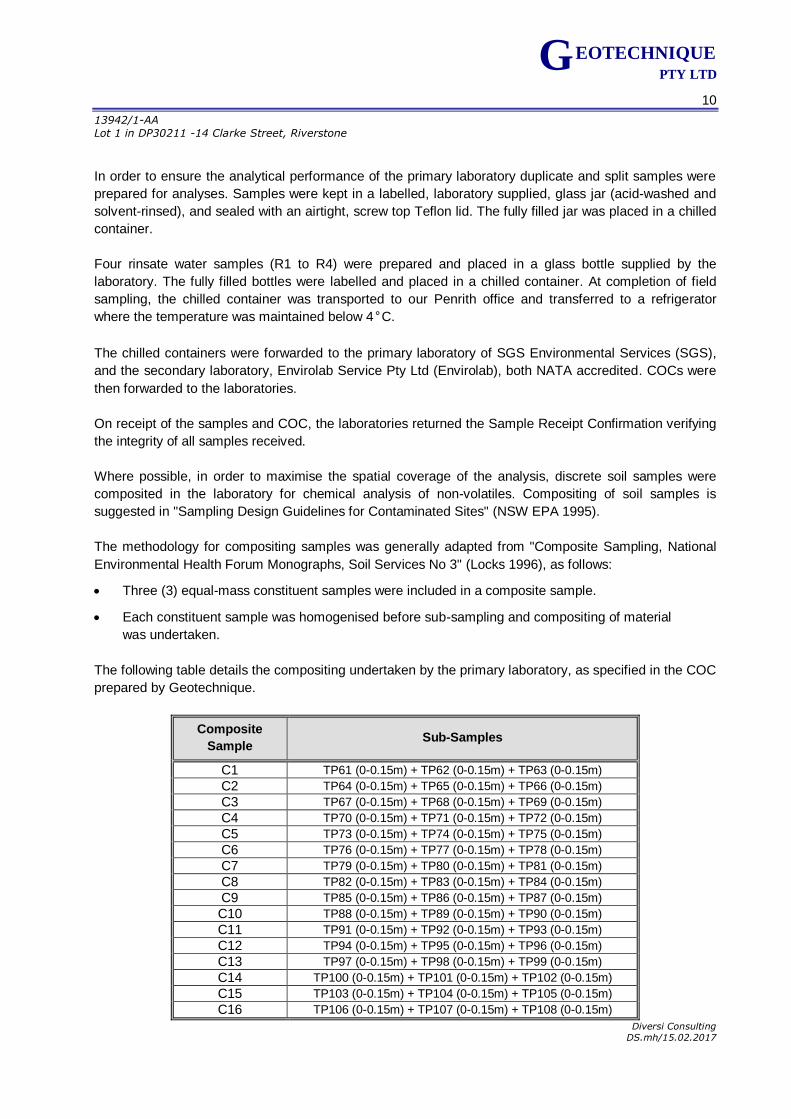
The following table details the compositing undertaken by the primary laboratory, as specified in the COC
prepared by Geotechnique.
Composite
Sample Sub-Samples
C1 TP61 (0-0.15m) + TP62 (0-0.15m) + TP63 (0-0.15m)
C2 TP64 (0-0.15m) + TP65 (0-0.15m) + TP66 (0-0.15m)
C3 TP67 (0-0.15m) + TP68 (0-0.15m) + TP69 (0-0.15m)
C4 TP70 (0-0.15m) + TP71 (0-0.15m) + TP72 (0-0.15m)
C5 TP73 (0-0.15m) + TP74 (0-0.15m) + TP75 (0-0.15m)
C6 TP76 (0-0.15m) + TP77 (0-0.15m) + TP78 (0-0.15m)
C7 TP79 (0-0.15m) + TP80 (0-0.15m) + TP81 (0-0.15m)
C8 TP82 (0-0.15m) + TP83 (0-0.15m) + TP84 (0-0.15m)
C9 TP85 (0-0.15m) + TP86 (0-0.15m) + TP87 (0-0.15m)
C10 TP88 (0-0.15m) + TP89 (0-0.15m) + TP90 (0-0.15m)
C11 TP91 (0-0.15m) + TP92 (0-0.15m) + TP93 (0-0.15m)
C12 TP94 (0-0.15m) + TP95 (0-0.15m) + TP96 (0-0.15m)
C13 TP97 (0-0.15m) + TP98 (0-0.15m) + TP99 (0-0.15m)
C14 TP100 (0-0.15m) + TP101 (0-0.15m) + TP102 (0-0.15m)
C15 TP103 (0-0.15m) + TP104 (0-0.15m) + TP105 (0-0.15m)
C16 TP106 (0-0.15m) + TP107 (0-0.15m) + TP108 (0-0.15m)
11
13942/1-AA
Lot 1 in DP30211 -14 Clarke Street, Riverstone
Diversi Consulting DS.mh/15.02.2017
G EOTECHNIQUE PTY LTD
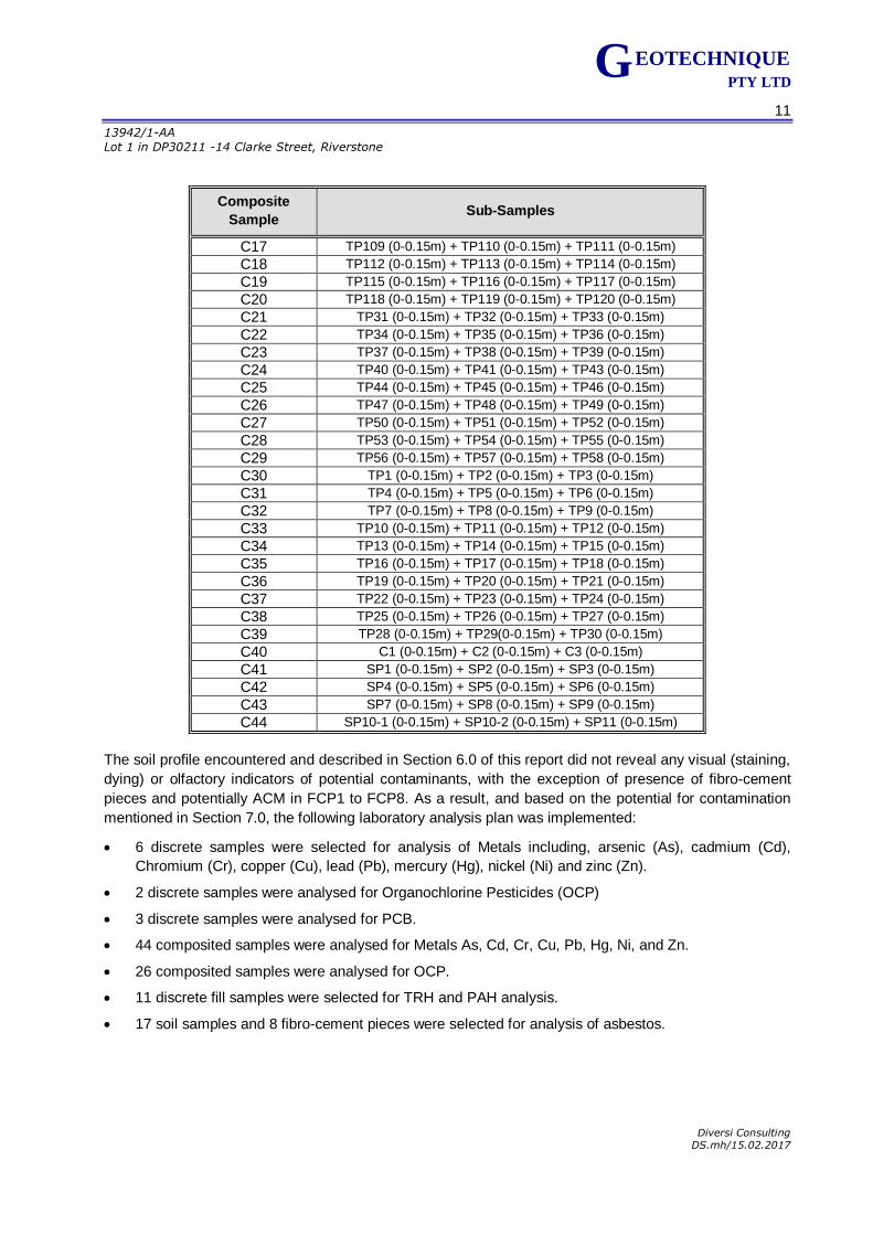
Composite
Sample Sub-Samples
C17 TP109 (0-0.15m) + TP110 (0-0.15m) + TP111 (0-0.15m)
C18 TP112 (0-0.15m) + TP113 (0-0.15m) + TP114 (0-0.15m)
C19 TP115 (0-0.15m) + TP116 (0-0.15m) + TP117 (0-0.15m)
C20 TP118 (0-0.15m) + TP119 (0-0.15m) + TP120 (0-0.15m)
C21 TP31 (0-0.15m) + TP32 (0-0.15m) + TP33 (0-0.15m)
C22 TP34 (0-0.15m) + TP35 (0-0.15m) + TP36 (0-0.15m)
C23 TP37 (0-0.15m) + TP38 (0-0.15m) + TP39 (0-0.15m)
C24 TP40 (0-0.15m) + TP41 (0-0.15m) + TP43 (0-0.15m)
C25 TP44 (0-0.15m) + TP45 (0-0.15m) + TP46 (0-0.15m)
C26 TP47 (0-0.15m) + TP48 (0-0.15m) + TP49 (0-0.15m)
C27 TP50 (0-0.15m) + TP51 (0-0.15m) + TP52 (0-0.15m)
C28 TP53 (0-0.15m) + TP54 (0-0.15m) + TP55 (0-0.15m)
C29 TP56 (0-0.15m) + TP57 (0-0.15m) + TP58 (0-0.15m)
C30 TP1 (0-0.15m) + TP2 (0-0.15m) + TP3 (0-0.15m)
C31 TP4 (0-0.15m) + TP5 (0-0.15m) + TP6 (0-0.15m)
C32 TP7 (0-0.15m) + TP8 (0-0.15m) + TP9 (0-0.15m)
C33 TP10 (0-0.15m) + TP11 (0-0.15m) + TP12 (0-0.15m)
C34 TP13 (0-0.15m) + TP14 (0-0.15m) + TP15 (0-0.15m)
C35 TP16 (0-0.15m) + TP17 (0-0.15m) + TP18 (0-0.15m)
C36 TP19 (0-0.15m) + TP20 (0-0.15m) + TP21 (0-0.15m)
C37 TP22 (0-0.15m) + TP23 (0-0.15m) + TP24 (0-0.15m)
C38 TP25 (0-0.15m) + TP26 (0-0.15m) + TP27 (0-0.15m)
C39 TP28 (0-0.15m) + TP29(0-0.15m) + TP30 (0-0.15m)
C40 C1 (0-0.15m) + C2 (0-0.15m) + C3 (0-0.15m)
C41 SP1 (0-0.15m) + SP2 (0-0.15m) + SP3 (0-0.15m)
C42 SP4 (0-0.15m) + SP5 (0-0.15m) + SP6 (0-0.15m)
C43 SP7 (0-0.15m) + SP8 (0-0.15m) + SP9 (0-0.15m)
C44 SP10-1 (0-0.15m) + SP10-2 (0-0.15m) + SP11 (0-0.15m)
The soil profile encountered and described in Section 6.0 of this report did not reveal any visual (staining,
dying) or olfactory indicators of potential contaminants, with the exception of presence of fibro-cement
pieces and potentially ACM in FCP1 to FCP8. As a result, and based on the potential for contamination
mentioned in Section 7.0, the following laboratory analysis plan was implemented:
6 discrete samples were selected for analysis of Metals including, arsenic (As), cadmium (Cd),
Chromium (Cr), copper (Cu), lead (Pb), mercury (Hg), nickel (Ni) and zinc (Zn).
2 discrete samples were analysed for Organochlorine Pesticides (OCP)
3 discrete samples were analysed for PCB.
44 composited samples were analysed for Metals As, Cd, Cr, Cu, Pb, Hg, Ni, and Zn.
26 composited samples were analysed for OCP.
11 discrete fill samples were selected for TRH and PAH analysis.
17 soil samples and 8 fibro-cement pieces were selected for analysis of asbestos.
12
13942/1-AA
Lot 1 in DP30211 -14 Clarke Street, Riverstone
Diversi Consulting DS.mh/15.02.2017
G EOTECHNIQUE PTY LTD
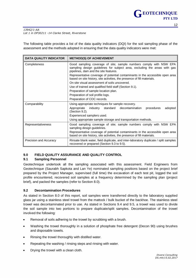
The following table provides a list of the data quality indicators (DQI) for the soil sampling phase of the
assessment and the methods adopted in ensuring that the data quality indicators were met:
DATA QUALITY INDICATOR METHOD(S) OF ACHIEVEMENT
Completeness Good sampling coverage of site; sample numbers comply with NSW EPA sampling design guidelines for subject area, excluding the areas with gas pipelines, dam and the site features.
Representative coverage of potential contaminants in the accessible open area based on site history, site activities, the presence of fill materials.
On site visual assessment of soils uncovered.
Use of trained and qualified field staff (Section 9.1).
Preparation of sample location plan.
Preparation of soil profile logs.
Preparation of COC records.
Comparability Using appropriate techniques for sample recovery.
Appropriate industry standard decontamination procedures adopted (Section 9.2).
Experienced samplers used.
Using appropriate sample storage and transportation methods.
Representativeness Good sampling coverage of site; sample numbers comply with NSW EPA sampling design guidelines.
Representative coverage of potential contaminants in the accessible open area based on site history, site activities, the presence of fill materials.
Precision and Accuracy Rinsate blank water, field duplicate, and inter-laboratory duplicate / split samples recovered or prepared (Section 9.3 to 9.5).
9.0 FIELD QUALITY ASSURANCE AND QUALITY CONTROL
9.1 Sampling Personnel
Geotechnique undertook all the sampling associated with this assessment. Field Engineers from
Geotechnique (Saurabh Sapkota and Lan Ye) nominated sampling positions based on the project brief
prepared by the Project Manager, supervised (full time) the excavation of each test pit, logged the soil
profile encountered, recovered soil samples at a frequency determined by the sampling plan (project
brief), and packed the samples (refer to Section 8.0).
9.2 Decontamination Procedures
As stated in Section 8.0 of this report, soil samples were transferred directly to the laboratory supplied
glass jar using a stainless steel trowel from the mattock / bulk bucket of the backhoe. The stainless steel
trowel was decontaminated prior to use. As stated in Sections 9.4 and 9.5, a trowel was used to divide
the soil sample into two portions to prepare duplicate/split samples. Decontamination of the trowel
involved the following:
Removal of soils adhering to the trowel by scrubbing with a brush.
Washing the trowel thoroughly in a solution of phosphate free detergent (Decon 90) using brushes
and disposable towels.
Rinsing the trowel thoroughly with distilled water.
Repeating the washing / rinsing steps and rinsing with water.
Drying the trowel with a clean cloth.
13
13942/1-AA
Lot 1 in DP30211 -14 Clarke Street, Riverstone
Diversi Consulting DS.mh/15.02.2017
G EOTECHNIQUE PTY LTD
A sample of the final rinsate water sample was recovered at completion of field sampling.
9.3 Rinsate Samples
Four rinsate water samples were prepared in order to identify possible cross contamination between the
sampling locations.
The rinsate water samples were analysed for Metals. The test results for the rinsate water sample are
summarised in Table A. The laboratory test results certificates are kept in the offices of Geotechnique,
and are available upon request.
As indicated in Table A, the metal concentrations in the rinsate blank sample were generally less than
laboratory limits of reporting (LOR),indicating that the cleaning and decontamination processes adopted
in the field were adequate.
9.4 Duplicate Samples
Field duplicate samples were prepared in the field through the following process:
A larger than normal quantity of soil was recovered from the sample location selected for duplication.
The sample was divided into two portions, using the decontaminated trowel.
One portion of the sub-sample was immediately transferred, using the decontaminated trowel, into a
labelled, laboratory supplied, 250ml glass jar and sealed with an airtight, Teflon screw top lid. The
fully filled jar was labelled as the duplicate sample and immediately placed in a chilled container.
The remaining portion was stored in the same way, and labelled as the original sample.
Duplicate samples were prepared on the basis of sample numbers recovered during the field work. The
duplicate sample frequency was computed using the total number of samples analysed as part of this
assessment. The duplicate sample frequencies computed are as follows:
Metals: 50 samples analysed; 3 duplicates; 6% frequency
OCP 28 samples analysed; 2 duplicate; 7% frequency
The laboratory test results are summarised in Tables B1 to B3. The laboratory test results certificates are
kept in the offices of Geotechnique, and are available upon request.
A comparison was made of the laboratory test results for the duplicate samples with the original samples
and the Relative Percentage Differences (RPD) were computed to assess the accuracy of the laboratory
test procedures. RPD within 30% are generally considered acceptable. However, this variation can be
higher for organic analysis than for inorganics, and for low concentrations of analytes.
As shown in Tables B1 to B3, the comparisons between the duplicate and corresponding original sample
indicated acceptable RPD.
Therefore, the variation is not considered critical and the laboratory test data provided by SGS are of
adequate accuracy and reliability for this assessment.
14
13942/1-AA
Lot 1 in DP30211 -14 Clarke Street, Riverstone
Diversi Consulting DS.mh/15.02.2017
G EOTECHNIQUE PTY LTD
9.5 Inter-laboratory Duplicate (Split) Sample
Inter-laboratory duplicate (split) samples provide a check on the analytical performance of the primary
laboratory. The split samples were prepared on the basis of sample numbers recovered during field work,
and the analyses undertaken by the primary laboratory.
The split samples were prepared in the same manner as the duplicate sample. Reference should be
made to Section 9.5.
Split samples were forwarded to the secondary laboratory of Envirolab.
The split sample frequency was computed using the total number of samples analysed as part of this
assessment. The split sample frequencies computed are as follows:
Metals: 50 samples analysed; 3 splits; 6% frequency
OCP 28 samples analysed; 3 splits; 7% frequency
The results are also summarised in Tables C1 to C3. The laboratory test results certificates are kept in
the offices of Geotechnique, and are available upon request.
Based on Schedule B (3) of the NEPM 1999 (April 2013), the difference in the results between the split
samples should generally be within 30% of the mean concentration determined by both laboratories, i.e.,
RPD should be within 30%. However, this variation can be higher for organic analysis than for inorganics
and for low concentrations of analytes.
As shown in Tables C1 to C3, the comparisons between the split and corresponding original sample
indicated generally acceptable RPD, with the exception of higher RPD of 34% for Ni, mainly considered
due to the relatively lower concentrations of metals detected. The concentrations with RPD in excess of
30% in the duplicate pairs were both less than the relevant assessment criteria .Therefore, the variations
are not considered critical and the test results provided by the primary laboratory are deemed reliable for
this assessment.
10.0 LABORATORY QUALITY ASSESSMENT AND QUALITY CONTROL
Geotechnique uses only laboratories accredited by the NATA for chemical analyses. The laboratory must
also incorporate quality laboratory management systems to ensure that trained analysts using validated
methods and suitably calibrated equipment produce reliable results.
In addition to the QC samples, the laboratory must also ensure that all analysts receive certification as to
their competence in carrying out the analyses, and participate in national and international proficiency
studies.
SGS and Envirolab are accredited by NATA and operate Quality Systems designed to comply with ISO /
IEC 17025.
The recovered discrete and composited soil samples were generally analysed within the allowable
holding times detailed in Schedule B(3) of The NEPM 1999 (April 2013) . It should be noted that there is
no specific holding time for asbestos analysis. The rinsate samples were generally analysed within the
allowable holding times for water detailed in Standard Methods for the Examination of Water and
Wastewater (APHA).
15
13942/1-AA
Lot 1 in DP30211 -14 Clarke Street, Riverstone
Diversi Consulting DS.mh/15.02.2017
G EOTECHNIQUE PTY LTD
The test methods adopted by the laboratories are indicated with the laboratory test results certificates. As
part of the analytical run for the project, the laboratories included laboratory blanks, duplicate samples,
laboratory control samples, matrix spikes and/or surrogate spikes.
We have checked the QA/QC procedures and results adopted by the laboratories against the appropriate
guidelines. The QC sample numbers adopted by SGS and Envirolab are considered adequate for the
analyses undertaken.
The methods used by SGS and Envirolab have been validated as recommended in the NEPM and
ANZECC guidelines and endorsed by NATA.
Samples analysed for TPH (C6–C9) and/or BTEX were extracted by the purge and trap method
recommended by the NSW EPA.
All reported laboratory LOR / Practical Quantitation Limits (PQL) were less than the assessment criteria
adopted for each analyte or analyte group.
Overall, the QC elements adopted by SGS and Envirolab indicate that the analytical data falls within
acceptable levels of accuracy and precision for the analysis of soils and water. The analytical data
provided is therefore considered to be reliable and useable for this assessment.
11.0 QA/QC DATA EVALUATION
The following table provides a list of the DQI for the analytical phase of the assessment and the methods
adopted in ensuring that the DQI were met.
DATA QUALITY INDICATOR METHOD(S) OF ACHIEVEMENT
Data Completeness Laboratory sample receipt information received confirming receipt of samples intact and appropriate chain of custody.
Analysis for all potential contaminants of concern.
NATA registered laboratory analytical reports / certificates of analysis provided.
Data Comparability Use of NATA registered laboratories.
Test methods consistent for each sample.
Test methods comparable between primary and secondary laboratory.
Generally, acceptable RPD between original samples and field duplicates and split samples.
Data Representativeness Representative coverage of potential contaminants in the open area based on site history, site activities, the presence of fill materials.
Adequate duplicate, split and rinsate sample numbers, in general.
Adequate laboratory internal QC and QA methods, complying with the NEPM 1999 (April 2013).
Data Precision and Accuracy Acceptable concentrations in rinsate blank water samples.
Acceptable RPD for duplicate comparison overall.
Acceptable RPD for inter-laboratory duplicate / split sample comparison overall.
Appropriate and validated laboratory test methods used.
Adequate laboratory performance based on results of the blank samples, duplicates, surrogate spike samples, control samples and/or matrix spike samples.
16
13942/1-AA
Lot 1 in DP30211 -14 Clarke Street, Riverstone
Diversi Consulting DS.mh/15.02.2017
G EOTECHNIQUE PTY LTD
Based on the above, it is considered that both laboratories complied with the QA and QC DQI. As such, it
is concluded that the laboratory test data obtained is reliable and useable for this assessment.
12.0 ASSESSMENT CRITERIA
Investigation levels and screening levels developed in the NEPM 1999 (April 2013) were used in this
assessment for soil samples, as follows:
Risk-based Health Investigation Levels (HIL) for a broad range of metals and organic substances.
The HIL are applicable for assessing human health risk via all relevant pathways of exposure. The
HIL as listed in Table 1A (1) of Schedule B1 “Guideline on Investigation Levels for Soil and
Groundwater” are provided for different land uses.
The site is proposed for residential subdivision development. As such, with regard to human health,
analytical results will be assessed against risk based HIL for residential with garden/accessible soil
(HIL A).
Health Screening Levels (HSL) for TRH fractions and Naphthalene are applicable for assessing
human health risk via inhalation and direct contact pathways. The HSL depend on specific soil
physicochemical properties, land use scenarios and the characteristics of building structures. The
HSL listed in Table 1A(3) of Schedule B1 “Guideline on Investigation Levels for Soil and
Groundwater” apply to different soil types and depths below surface to >4 m.
For this assessment, the analytical results were assessed against the available HSL for residential
with garden/accessible soil (HSL A).
Ecological Screening Levels (ESL) for selected petroleum hydrocarbon compounds, TPH fractions
and Benzo(a)Pyrene are applicable for assessing the risk to terrestrial ecosystems. ESL listed in
Table 1B(6) of Schedule B1 “Guideline on Investigation Levels for Soil and Groundwater” broadly
apply to coarse and fine-grained soils and various land uses and are generally applicable to the top
2m of soil.
The analytical result was assessed against the available ESL for residential with garden/accessible
soil.
EIL, a specific type of Soil Quality Guidelines (SQG) for selected metals, are applicable for assessing
the risk to terrestrial ecosystems. EIL listed in Table 1B(1-5) of Schedule B1 “Guideline on
Investigation Levels for Soil and Groundwater” depend on specific soil physicochemical properties
and land use scenarios and generally apply to the top 2m of soil. For arsenic and lead, generic EIL
are adopted for urban residential land use for aged contamination. For other metals, where available,
EIL are calculated using the EIL calculator developed by CSIRO for NEPC.
For this assessment, the analytical results were assessed against the available SQG / EIL for urban
residential land use for aged contamination in soil for low traffic volume.
For cadmium and mercury, the available Provisional Phytotoxicity Based Investigation Levels (PIL)
published in the Guidelines for the NSW Site Auditor Scheme (NSW DEC, 2006) were used, with
regard to protection of the environment and impact on plant growth.
In order to detect any potential "hot spots" of contamination within an individual composite soil sample, an
Adjusted HIL A / EIL is recommended for assessment of results for individual composite samples, based
on Method 1, Section 6 of the EPA "Sampling Design Guidelines" (NSW EPA 1995). The Adjusted HIL A /
EIL presented in the applicable tables were calculated by dividing the HIL A / EIL by three (i.e. three sub-
samples comprised the composite). Individual composite samples were assessed against the Adjusted
HIL A / EIL.
17
13942/1-AA
Lot 1 in DP30211 -14 Clarke Street, Riverstone
Diversi Consulting DS.mh/15.02.2017
G EOTECHNIQUE PTY LTD
Similarly, individual composite soil samples for cadmium and mercury were assessed against the
Adjusted PIL / HIL A.
If the concentration of an analyte for a composite soil sample is in excess of the Adjusted EIL / HIL A or
adjusted PIL / HIL A (for cadmium and mercury only), then all sub-samples of the failed composite
samples will be analysed individually. The purpose of this is to detect potentially contaminated sub-
samples within the failed composite sample.
For discrete soil samples, the individual concentrations of analytes were assessed against the HIL A /
HSL A / ESL / EIL. The individual concentrations of cadmium and mercury were assessed against the PIL
and HIL A.
For asbestos assessment, the site must be free of asbestos-cement pieces and no asbestos fibre/fibrous
asbestos (AF/FA) detected in the soils.
The site will be deemed contaminated or containing contamination “hot spots” if the above criteria are
unfulfilled. Further investigation, remediation and/or management will be recommended if the area of
concern is found to be contaminated or containing contamination “hot spots”.
13.0 FIELD & LABORATORY TEST RESULTS, ASSESSMENT & DISCUSSION
13.1 Field Results
Details of the sub-surface conditions encountered during field work for this assessment are presented in
Test Pit Logs in Appendix D of this report.
13.2 Analytical Results – Soil Samples
Copies of the actual laboratory test result certificates from SGS are kept in the offices of Geotechnique,
and can be provided upon request. A summary of the test results is presented in Tables D to L, with the
available assessment criteria adopted. A discussion of the test data is presented in the following sub-
sections.
13.2.1 Metals (As, Cd, Cr, Cu, Pb, Hg, Ni & Zn), pH and CEC
Test results of Cation Exchange Capacity (CEC) and pH are presented in Tables E, and were utilised to
calculate EILs in Table D and F.
The Metals test results for discrete samples are presented in Table D, and as shown, all concentrations of
Metals were below the available relevant EIL or PIL and HIL A.
The Metals test results for composited samples are presented in Tables F and as indicated, all
concentrations of Metals were below the relevant available Adjusted EIL and Adjusted HIL A, with the
exception of highlighted Cu and Zn concentrations. All concentrations of Cd and Hg were also below the
relevant adjusted PIL.
The sub-samples of the failed composite samples were therefore analysed for Cu and/or Zn. The test
results are summarised in Tables G1 and G2.
As shown in Tables G1, all concentrations of Cu were below the relevant EIL and the HIL A.
18
13942/1-AA
Lot 1 in DP30211 -14 Clarke Street, Riverstone
Diversi Consulting DS.mh/15.02.2017
G EOTECHNIQUE PTY LTD
As shown in Tables G2, all concentrations of Zn were below the relevant EIL and the HIL A, with the
exception of the highlighted concentration of zinc at location SP6. The elevated concentration of zinc
would not pose a risk of harm to human health, but would pose a risk of harm to the environment
(terrestrial ecosystems).
13.2.2 TRH and BTEX
The TRH and BTEX test results are presented in Table F. As shown in Table H, the concentrations of F1
(TRH C6-C10 less BTEX), F2 (TRH >C10-C16 less Naphthalene), F3 (TRH >C16-C34), F4 (TRH >C34-
C40) and BTEX were below the relevant HSL A and ESL.
13.2.3 Polycyclic Aromatic Hydrocarbons (PAH)
The PAH test results are presented in Table I and as shown, concentrations of Benzo(a)Pyrene,
Benzo(a)Pyrene (TEQ), Naphthalene and Total PAH were well below the relevant thresholds (HIL A,
ESL, HSL A and EIL).
13.2.4 Organochlorine Pesticides (OCP) and PCB
The OCP and PCB test results are presented in Table J for discrete samples analysed. As indicated, the
concentrations of OCP and PCB were well below the relevant HIL A. Concentrations of DDT were also
below the EIL.
The OCP test results are presented in Table K and as indicated, the concentrations of OCP were below
the Adjusted EIL. Concentrations of DDT were also below the Adjusted EIL.
13.2.5 Asbestos
The asbestos test results for the soil samples are presented in Table L and as indicated, FA (<7mm) was
detected in soil samples analysed at TP2 (0-0.15m) and SP10-1 (0-0.15m). ACM (>7mm) was found in
SP3 0-0.15m.
The fibro-cement pieces collected for asbestos analysis from locations FCP, FCP2-1, FCP3 and FCP4,
FCP5, FCP6 & FCP7 (Stockpile 10) were confirmed to contain asbestos, and are considered ACM.
Asbestos was not detected in the fibro-cement piece collected from FCP2-2.
Based on this assessment, it is our opinion that:
Delineation of the extent of asbestos contamination will be required at and in the vicinity of locations
of concern (FCP1, FCP2-1, FCP3, FCP4, FCP5, FCP6 and FCP7 (Stockpile 10), SP3 and TP2.
A WorkCover licensed Asbestos Assessor must be engaged to deal with management / clearance of
asbestos contamination.
Assessment of contamination status of soils within and in the vicinity of the footprints of existing site features after complete demolition and/or removal will be required. The purpose of this is to ascertain the presence or otherwise of “suspect” materials (identified by unusual staining, odour, discolouration or inclusions such as building rubble, asbestos, ash particles, etc.) and fill. In the event of contamination, detailed assessment, remediation and validation will be required.
19
13942/1-AA
Lot 1 in DP30211 -14 Clarke Street, Riverstone
Diversi Consulting DS.mh/15.02.2017
G EOTECHNIQUE PTY LTD
14.0 SITE CHARACTERISATION
Based on the test results for this PCA, the identified locations of concern are indicated and tabulated on
Drawing No 13942/1-AA3 and summarised below:
Locations where FA/AF are present in the fill profile presents a risk of harm to human health.
Locations where bonded ACM fragments in the fill profile potentially present a risk of harm to human
health.
Location where elevated concentrations of zinc would present a risk of harm to the environment, but
would not pose a risk of harm to human health.
Off-site impacts of contaminated soil are generally governed by the contaminant concentrations in the
soils, the transport media available and likely receptors. The most common transport medium is water,
whilst receptors include groundwater, surface waterbodies, humans, flora and fauna.
Migration of soil contaminants to the deeper soils or groundwater regime would generally be via leaching
of contaminants from the surface soil, facilitated by infiltration of surface water. The natural silty clay
beneath the site is relatively impermeable. As such, leaching of any contaminants into the groundwater
regime is unlikely.
15.0 CONCLUSION AND RECOMMENDATIONS
The findings of this PCA are summarised as follows:
The site contained various site features, as shown on Drawing No 13942/1-AA1 and Site
Photographs in Appendix E.
The general sub-surface profiles at the test pit / samples locations and soil profile in stockpile were
as follows:
Fill (thickness ranging from 150mm to 400mm), comprising silty clay, medium plasticity, brown
with gravel underlain by natural soil within the test pits TP1 to TP3. Only surface samples
(0-0.15m) were recovered from TP1 and TP2, due to access limitations. Full depth of the fill to
be determined at later stage.
Topsoil (thickness ranging 200 to 600mm) comprising, gravelly silt, low plasticity, with inclusion
of shale fragments, underlain by natural soil at TP4 to TP120. Topsoil with thickness of 600mm
was encountered in TP20 to TP24. Topsoil, comprising, silty clay, low to medium plasticity,
brown, with gravel was also observed at locations C1 to C3 in the vicinity of abandoned car
locations.
FCP and potentially ACM were observed at isolated locations, and representative samples of
FCP were collected for analysis of asbestos from locations FCP1 to FCP8.
Stockpile comprising silty sands, fine grained grey, silty clay, low to medium plasticity, brown
with gravel with or without building debris, concrete and terracotta fragments, were encountered
within the stockpile locations SP1 to SP11.
20
13942/1-AA
Lot 1 in DP30211 -14 Clarke Street, Riverstone
Diversi Consulting DS.mh/15.02.2017
G EOTECHNIQUE PTY LTD
As presented in the summary tables (Tables D to L) and discussed in Section 13.2, the majority of
the laboratory test results satisfied the criteria for stating that the analytes selected are either not
present i.e. concentrations less than laboratory LOR, or present in the sampled soil at concentrations
that do not pose a risk of harm to human health or the environment under a “residential with access
to soil” form of development, with the exception of elevated concentrations of Zn at test pit location
(SP4), the presence of FA/AF within the soil sample at locations TP2 (0-0.15m) and SP10-1 (0-
0.15m), and the presence of ACM at FCP1, FCP2-1, FCP3, FCP4, FCP5, FCP6, FCP7, and SP3
(0-0.15m). The elevated concentration of Zn might present a risk of harm to the environment
(terrestrial ecosystems). The presence of FA/AF will present a risk of harm to human health. The
presence of ACM would potentially present a risk of harm to human health.
Based on this PCA, the site is considered environmentally suitable for the proposed residential
development subject to following:
Detailed assessment of ACM (>7mm) and FA (<7mm) impacted soils as indicated on Drawing No
13942/1-AA3, to determine the extent of asbestos contamination within the site, and asbestos
clearance of the site by Safe Work licensed asbestos assessor.
Detailed assessment to determine the extent of Zn contamination at the identified location of concern
indicated on Drawing No 13942/1-AA3.
Assessment of soils in the footprints of existing site features after complete demolition and/or
removal by licensed contractor. The purpose of this is to ascertain the presence or otherwise of
“suspect” materials (identified by unusual staining, odour, discolouration or inclusions such as
building rubble, asbestos, ash particles, etc.) and fill.
Sampling and testing will be required to determine the contamination status of soils in the footprints
of site features. The type of testing on samples recovered from the footprints will depend on the
materials (topsoil, natural soil, suspect materials or fill) encountered. In the event of contamination,
detailed assessment, remediation and validation will be required.
Development of a remedial action plan (RAP) for the remediation of asbestos, Zn impacted soils, and
any other contamination identified through the detailed, additional sampling and testing beneath the
site features, followed by appropriate validation.
Assessment of the dam water prior to dewatering, to determine the contamination status of the water
and recommend dewatering method.
On completion of dewatering, contamination assessment of the dam sediment and dam walls should
be carried out.
It should be noted that since part of the site was used in the past and currently being used for agricultural
activities, there is a potential for buried irrigation pipes to remain beneath the ground surface. If any
asbestos pipes are uncovered, a qualified asbestos removal contractor must be engaged to carry out
removal. Asbestos clearance will be required after removal.
If any suspect materials (identified by unusual staining, odour, discolouration or inclusions such as
building rubble, asbestos sheets/pieces/pipes, ash material, etc.) are encountered during any stage of
future earthworks/site preparation/demolition/remediation, in areas other than mentioned above, or in
between the sampling locations or any areas masked by overgrown grass present within the site, the
Unexpected Finds Management Protocol (Appendix E) should be implemented. In the event of
contamination, detailed assessment, remediation and validation will be necessary.
21
13942/1-AA
Lot 1 in DP30211 -14 Clarke Street, Riverstone
Diversi Consulting DS.mh/15.02.2017
G EOTECHNIQUE PTY LTD
For any materials to be excavated and removed from the site, it is recommended that waste classification
of the materials is undertaken, in accordance with the "Waste Classification Guidelines Part 1: Classifying
Waste"( NSW EPA 2014), NSW EPA resource recovery exemptions and orders under the POEO (Waste)
Regulation 2014, or NSW EPA Certification: Virgin excavated natural material, prior to disposal at an
appropriately licensed landfill or potential re-use at other sites.
Any imported fill must be assessed by a qualified environmental consultant, prior to importation, to ensure
suitability for the proposed use. In addition, the imported fill must be free from asbestos, ash and odour,
not be discoloured and not acid sulphate soil. The imported fill should either be virgin excavated natural
material (VENM) or excavated natural material (ENM). Reference should be made to Section 16.0 of the
report and Appendix G, which set out details of the limitations of the assessment.
16.0 LIMITATIONS
Within the scope of work outlined in the fee proposal (Q7930 dated 10 January 2016) and the variation
emailed on 15 January 2016, the services performed by Geotechnique were conducted in a manner
consistent with the level of quality and skill generally exercised by members of the profession and
consulting practice.
This report has been prepared for Diversi Consulting (NSW) Pty Ltd for the purposes stated within. The
relevant council may rely upon the report for development and/or construction application determinations.
Reliance on this report by other parties shall be at such parties' sole risk, as the report might not contain
sufficient information for other purposes.
This report shall only be presented in full, and may not be used to support any objective other than those
set out in the report, except where written approval is provided by Geotechnique Pty Ltd.
The information in this report is considered accurate at completion of field sampling for this assessment
(30 January to 2 February 2017) in accordance with current site conditions. Any variations to the site form
or use beyond the sampling date could nullify the conclusions stated.
Whilst investigations conducted at the site were carried out in accordance with current NSW guidelines
the potential always exists for contaminated soils to be present between sampled locations or masked by
overgrown grass.
Presented in Appendix G is a document entitled "Environmental Notes", which should be read in
conjunction with this report.

Diversi Consulting DS.mh/15.02.2017
G EOTECHNIQUE PTY LTD
LIST OF REFERENCES
AS4482.1-2005, Guide to the Sampling and Investigation of Potentially Contaminated Soil Part 1: Non-
volatile and semi-volatile compounds, Standards Australia.
AS4482.2-1999, Guide to the Sampling and Investigation of Potentially Contaminated Soil Part 2: Volatile
substances, Standards Australia.
Clark, NR, and James, DC 1991, Geological Series Sheet 9030, Scale 1:100,000 (Penrith), Department
of Minerals and Energy, NSW, Sydney
Hazelton et al. 1989, Soil Landscape Series Sheet 9030, Scale 1:100,000 (Penrith), Soil Conservation
Service of NSW, Sydney
Contaminated Land Management Act 1997,
DUAP/EPA 1998, Managing Land Contamination: Planning Guidelines SEPP 55 – Remediation of Land,
Department of Urban Affairs and Planning / NSW Environment Protection Authority, Sydney, Australia.
Lock, WH 1996, Composite Sampling, National Environmental Health Forum Monographs, and Soil
Services No 3, South Australian Health Commission, Adelaide, Australia
NEPM 1999 (April 2013), National Environmental Protection (Assessment of Site Contamination)
Amendment Measures, 1999 (April 2013), National Environmental Protection Council (NEPC), Australia.
NSW DEC 2006, Contaminated Sites: Guidelines for the NSW Site Auditor Scheme (2nd Edition), NSW
Department of Environment and Climate Change, Sydney, Australia.
NSW EPA 2014, Waste Classification Guidelines, Part 1: Classifying Waste, New South Wales
Environment Protection Authority, November 2014.
NSW OEH 2011, Contaminated Sites: Guidelines for Consultants Reporting on Contaminated Sites, NSW
Office of NSW Office of Environment and Heritage, Sydney Australia.
NSW EPA 1995, Contaminated Sites: Sampling Design Guidelines, New South Wales Environment
Protection Authority, September, EPA 95/59, Sydney Australia.

DRAWINGS
DRAWINGS
Drawing No 13942/1-AA1 Site Features
Drawing No 13942/1-AA2 Test Pit Locations
Drawing No 13942/1-AA3 Locations/Areas of Concern
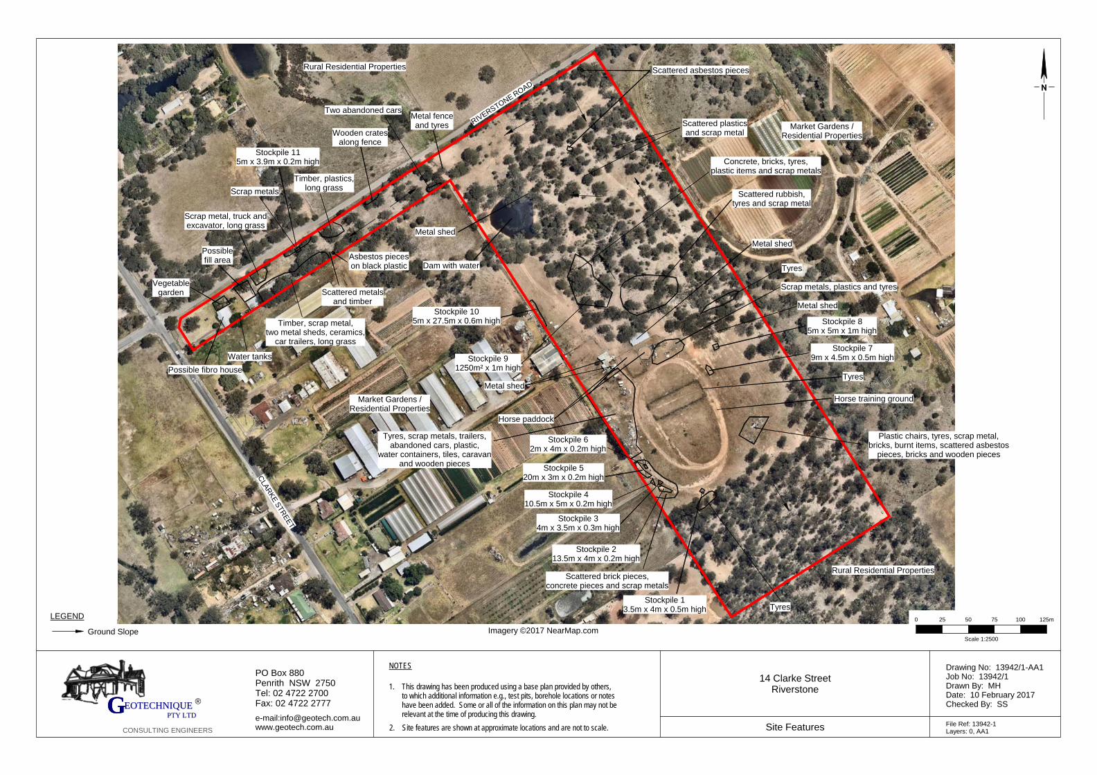
Imagery ©2017 NearMap.com
CLA
RK
E S
TR
EE
T
RIVERSTONE R
OAD
NOTES
This drawing has been produced using a base plan provided by others,to which additional information e.g., test pits, borehole locations or noteshave been added. Some or all of the information on this plan may not berelevant at the time of producing this drawing.Site features are shown at approximate locations and are not to scale.
1.
2.
14 Clarke StreetRiverstone
Drawing No: 13942/1-AA1Job No: 13942/1Drawn By: MHDate: 10 February 2017Checked By: SS
File Ref: 13942-1Layers: 0, AA1
Site Features
PO Box 880Penrith NSW 2750Tel: 02 4722 2700Fax: 02 4722 2777
e-mail:[email protected]
EEOOTTEECCHHNNIIQQUUEE GGG PPTTYY LLTTDD
CONSULTING ENGINEERS
LEGEND
Ground Slope
®
Scale 1:2500
0 25 50 75 100 125m
Timber, scrap metal,two metal sheds, ceramics,
car trailers, long grass
Water tanks
Possible fibro house
Vegetablegarden
Possiblefill area
Scrap metal, truck andexcavator, long grass
Scrap metals
Scattered metalsand timber
Asbestos pieceson black plastic
Timber, plastics,long grass
Wooden cratesalong fence
Two abandoned cars
Metal shed
Dam with water
Metal fenceand tyres Scattered plastics
and scrap metal
Scattered asbestos pieces
Scattered rubbish,tyres and scrap metal
Metal shed
Tyres
Scrap metals, plastics and tyres
Metal shed
Stockpile 85m x 5m x 1m high
Stockpile 79m x 4.5m x 0.5m high
Tyres
Horse training ground
Plastic chairs, tyres, scrap metal,bricks, burnt items, scattered asbestos
pieces, bricks and wooden pieces
TyresStockpile 1
3.5m x 4m x 0.5m high
Stockpile 213.5m x 4m x 0.2m high
Stockpile 34m x 3.5m x 0.3m high
Stockpile 410.5m x 5m x 0.2m high
Stockpile 520m x 3m x 0.2m high
Tyres, scrap metals, trailers,abandoned cars, plastic,
water containers, tiles, caravanand wooden pieces
Horse paddock
Metal shed
Stockpile 91250m² x 1m high
Stockpile 105m x 27.5m x 0.6m high
Stockpile 115m x 3.9m x 0.2m high
Scattered brick pieces,concrete pieces and scrap metals
Concrete, bricks, tyres,plastic items and scrap metals
Market Gardens /Residential Properties
Rural Residential Properties
Market Gardens /Residential Properties
Rural Residential Properties
Stockpile 62m x 4m x 0.2m high
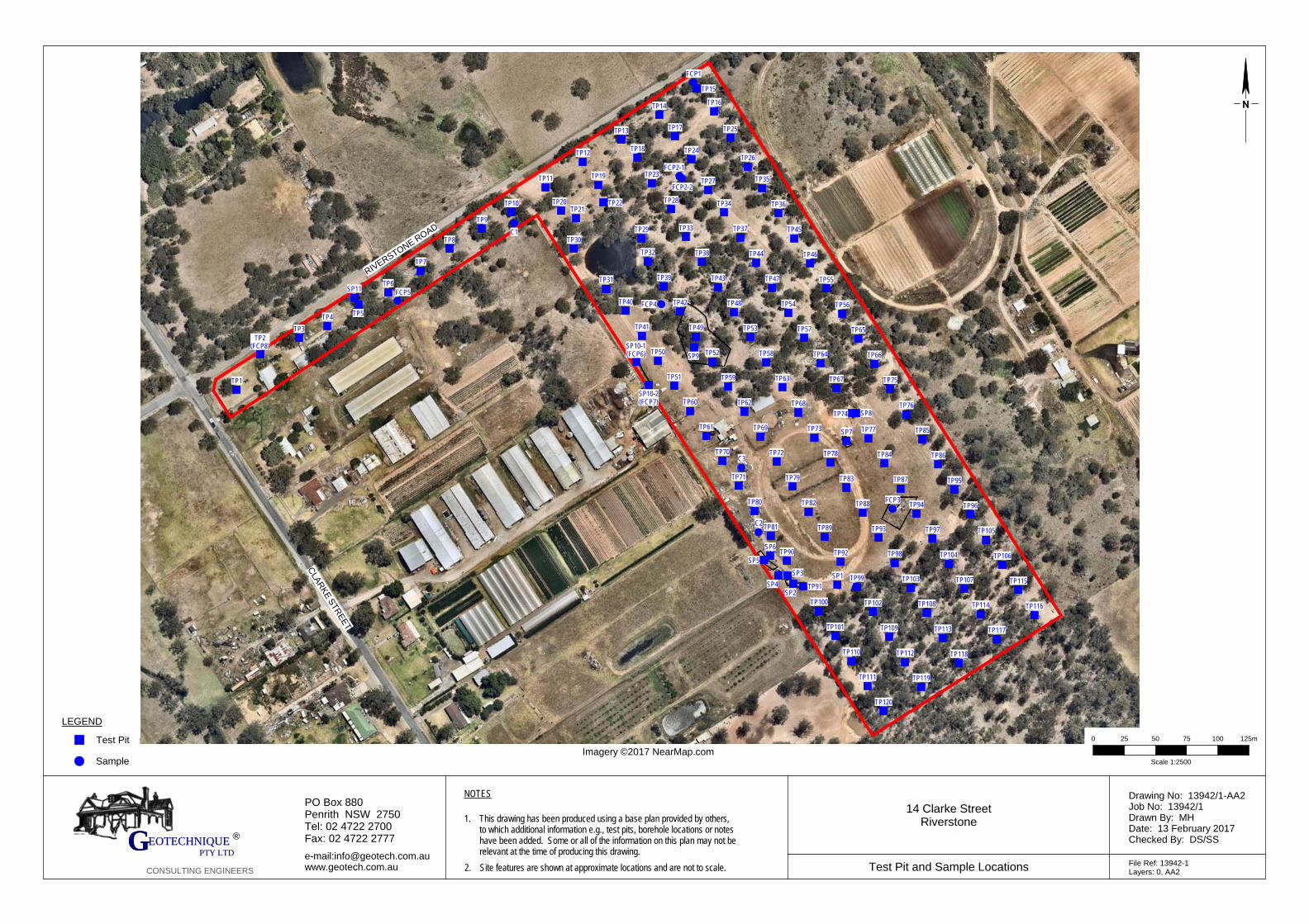
C2
C3
C1
FCP3
TP120
TP119
TP118
TP117
TP116
TP115
TP114
TP113
TP112
TP111
TP110
TP109
TP108
TP107
TP106
TP105
TP104
TP103
TP102
TP101
TP100
TP99
TP98
TP97
TP96
TP95
TP94
TP93
TP92
TP91
TP90
TP89
TP88
TP87
TP86
TP85
TP84
TP83
TP82
TP81
TP80
TP79
TP78
TP77
TP76
TP75
TP74
TP73
TP72
TP71
TP70
TP69
TP68
TP67
TP66
TP65
TP64
TP63
TP62
TP61
TP60
TP59
TP58
TP57
TP56
TP55
TP54
TP53
TP52
TP51
TP50
TP49
TP48
TP47
TP46
TP45
TP44
TP43
TP42
TP41
TP40
TP39
TP38
TP37
TP36
TP35
TP34
TP33
TP32
TP31
TP30TP29
TP28
TP27
TP26
TP25
TP24
TP23
TP22TP21
TP20
TP19
TP18
TP17
TP16
TP15
TP14
TP13
TP12
TP11
TP10
TP9
TP8
TP7
TP6
TP5TP4TP3
TP2(FCP8)
TP1
FCP1
FCP2-1
SP9SP10-1(FCP6)
SP10-2(FCP7)
SP11
SP8
SP7
SP1
SP2
SP3
SP6
SP5
SP4
FCP4FCP5
FCP2-2
Imagery ©2017 NearMap.com
CLA
RK
E S
TR
EE
T
RIVERSTONE R
OAD
NOTES
This drawing has been produced using a base plan provided by others,to which additional information e.g., test pits, borehole locations or noteshave been added. Some or all of the information on this plan may not berelevant at the time of producing this drawing.Site features are shown at approximate locations and are not to scale.
1.
2.
14 Clarke StreetRiverstone
Drawing No: 13942/1-AA2Job No: 13942/1Drawn By: MHDate: 13 February 2017Checked By: DS/SS
File Ref: 13942-1Layers: 0, AA2
Test Pit and Sample Locations
PO Box 880Penrith NSW 2750Tel: 02 4722 2700Fax: 02 4722 2777
e-mail:[email protected]
EEOOTTEECCHHNNIIQQUUEE GGG PPTTYY LLTTDD
CONSULTING ENGINEERS
LEGEND
Test Pit
®
Scale 1:2500
0 25 50 75 100 125m
Sample
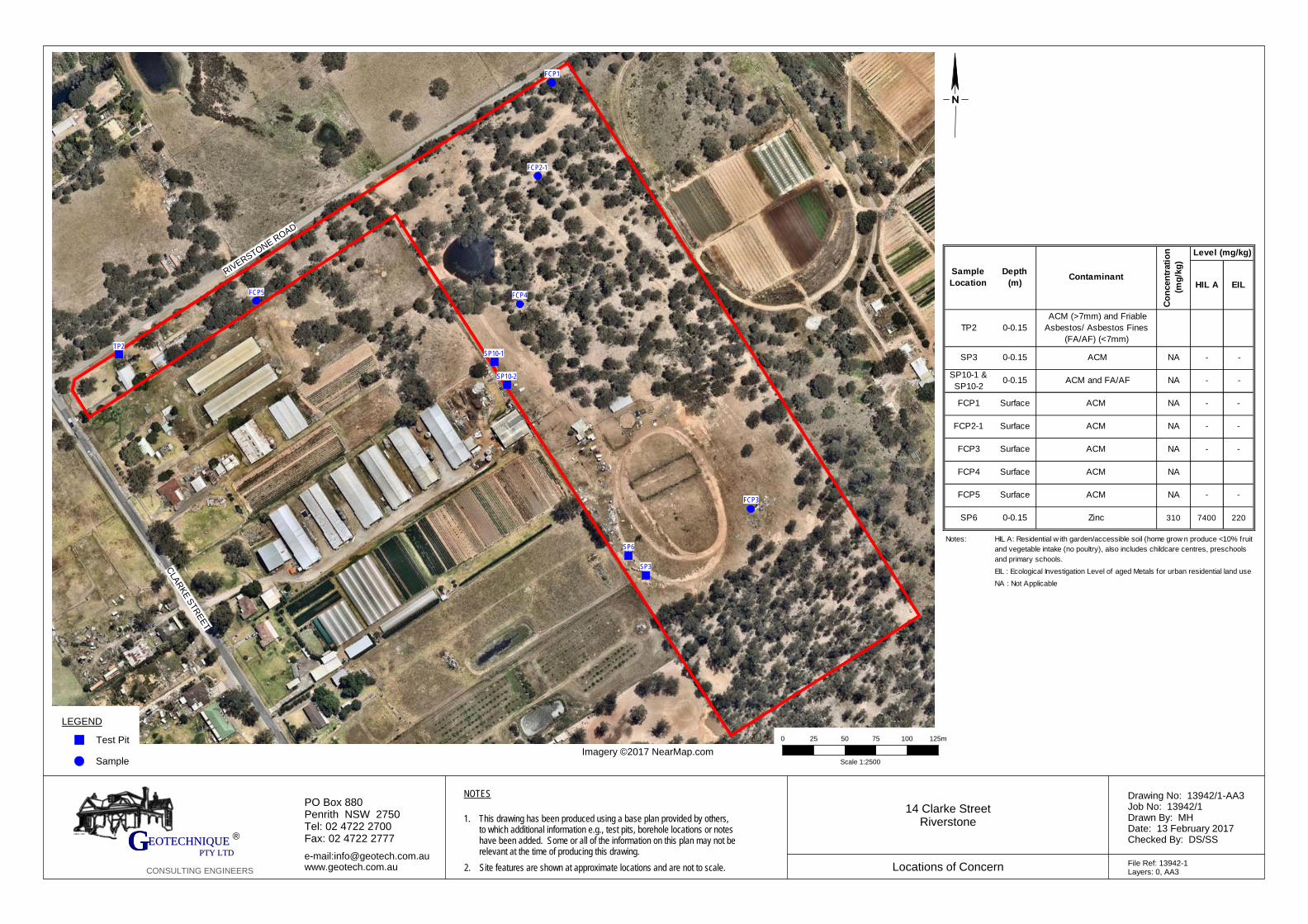
FCP3
TP2
FCP1
FCP2-1
SP10-1
SP10-2
SP3
SP6
FCP4FCP5
Imagery ©2017 NearMap.com
CLA
RK
E S
TR
EE
T
RIVERSTONE R
OAD
NOTES
This drawing has been produced using a base plan provided by others,to which additional information e.g., test pits, borehole locations or noteshave been added. Some or all of the information on this plan may not berelevant at the time of producing this drawing.Site features are shown at approximate locations and are not to scale.
1.
2.
14 Clarke StreetRiverstone
Drawing No: 13942/1-AA3Job No: 13942/1Drawn By: MHDate: 13 February 2017Checked By: DS/SS
File Ref: 13942-1Layers: 0, AA3
Locations of Concern
PO Box 880Penrith NSW 2750Tel: 02 4722 2700Fax: 02 4722 2777
e-mail:[email protected]
EEOOTTEECCHHNNIIQQUUEE GGG PPTTYY LLTTDD
CONSULTING ENGINEERS
LEGEND
Test Pit
®
Scale 1:2500
0 25 50 75 100 125m
Sample
HIL A EIL
TP2 0-0.15
ACM (>7mm) and Friable
Asbestos/ Asbestos Fines
(FA/AF) (<7mm)
SP3 0-0.15 ACM NA - -
SP10-1 &
SP10-20-0.15 ACM and FA/AF NA - -
FCP1 Surface ACM NA - -
FCP2-1 Surface ACM NA - -
FCP3 Surface ACM NA - -
FCP4 Surface ACM NA
FCP5 Surface ACM NA - -
SP6 0-0.15 Zinc 310 7400 220
Notes:
NA : Not Applicable
Co
ncen
trati
on
(mg
/kg
)
EIL : Ecological Investigation Level of aged Metals for urban residential land use
HIL A: Residential w ith garden/accessible soil (home grow n produce <10% fruit
and vegetable intake (no poultry), also includes childcare centres, preschools
and primary schools.
Level (mg/kg)
Contaminant Depth
(m)
Sample
Location
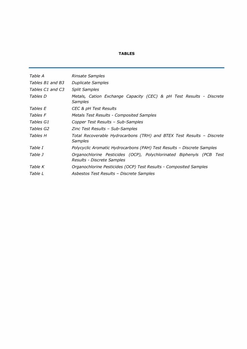
TABLES
Table A Rinsate Samples
Tables B1 and B3 Duplicate Samples
Tables C1 and C3 Split Samples
Tables D Metals, Cation Exchange Capacity (CEC) & pH Test Results - Discrete
Samples
Tables E CEC & pH Test Results
Tables F Metals Test Results - Composited Samples
Tables G1 Copper Test Results – Sub-Samples
Tables G2 Zinc Test Results – Sub-Samples
Tables H Total Recoverable Hydrocarbons (TRH) and BTEX Test Results – Discrete
Samples
Table I Polycyclic Aromatic Hydrocarbons (PAH) Test Results – Discrete Samples
Table J Organochlorine Pesticides (OCP), Polychlorinated Biphenyls (PCB Test
Results - Discrete Samples
Table K Organochlorine Pesticides (OCP) Test Results - Composited Samples
Table L Asbestos Test Results – Discrete Samples
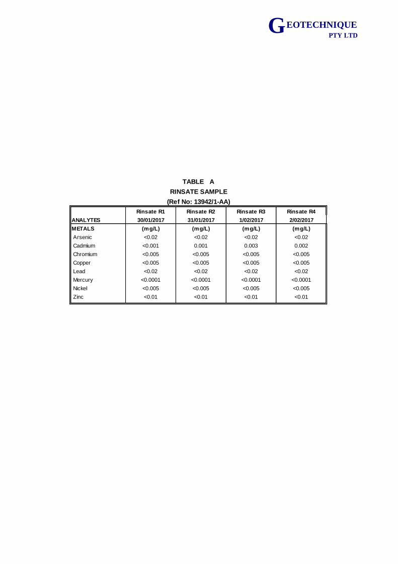
G EOTECHNIQUE PTY LTD
Rinsate R1 Rinsate R2 Rinsate R3 Rinsate R4
ANALYTES 30/01/2017 31/01/2017 1/02/2017 2/02/2017
METALS (mg/L) (mg/L) (mg/L) (mg/L)
Arsenic <0.02 <0.02 <0.02 <0.02
Cadmium <0.001 0.001 0.003 0.002
Chromium <0.005 <0.005 <0.005 <0.005
Copper <0.005 <0.005 <0.005 <0.005
Lead <0.02 <0.02 <0.02 <0.02
Mercury <0.0001 <0.0001 <0.0001 <0.0001
Nickel <0.005 <0.005 <0.005 <0.005
Zinc <0.01 <0.01 <0.01 <0.01
TABLE A
RINSATE SAMPLE
(Ref No: 13942/1-AA)
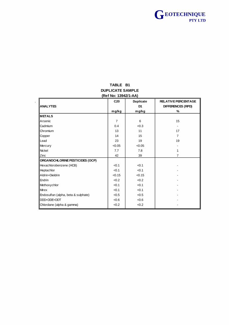
G EOTECHNIQUE PTY LTD
. C20 Duplicate RELATIVE PERCENTAGE
ANALYTES D1 DIFFERENCES (RPD)
mg/kg mg/kg %
METALS
Arsenic 7 6 15
Cadmium 0.4 <0.3 -
Chromium 13 11 17
Copper 14 15 7
Lead 23 19 19
Mercury <0.05 <0.05 -
Nickel 7.7 7.8 1
Zinc 42 39 7
ORGANOCHLORINE PESTICIDES (OCP)
Hexachlorobenzene (HCB) <0.1 <0.1 -
Heptachlor <0.1 <0.1 -
Aldrin+Dieldrin <0.15 <0.15 -
Endrin <0.2 <0.2 -
Methoxychlor <0.1 <0.1 -
Mirex <0.1 <0.1 -
Endosulfan (alpha, beta & sulphate) <0.5 <0.5 -
DDD+DDE+DDT <0.6 <0.6 -
Chlordane (alpha & gamma) <0.2 <0.2 -
TABLE B1
DUPLICATE SAMPLE
(Ref No: 13942/1-AA)
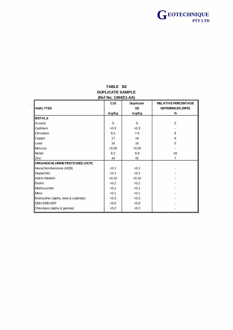
G EOTECHNIQUE PTY LTD
. C10 Duplicate RELATIVE PERCENTAGE
ANALYTES D2 DIFFERENCES (RPD)
mg/kg mg/kg %
METALS
Arsenic 5 5 0
Cadmium <0.3 <0.3 -
Chromium 8.2 7.6 8
Copper 17 18 6
Lead 16 16 0
Mercury <0.05 <0.05 -
Nickel 8.2 9.8 18
Zinc 44 41 7
ORGANOCHLORINE PESTICIDES (OCP)
Hexachlorobenzene (HCB) <0.1 <0.1 -
Heptachlor <0.1 <0.1 -
Aldrin+Dieldrin <0.15 <0.15 -
Endrin <0.2 <0.2 -
Methoxychlor <0.1 <0.1 -
Mirex <0.1 <0.1 -
Endosulfan (alpha, beta & sulphate) <0.5 <0.5 -
DDD+DDE+DDT <0.6 <0.6 -
Chlordane (alpha & gamma) <0.2 <0.2 -
TABLE B2
DUPLICATE SAMPLE
(Ref No: 13942/1-AA)
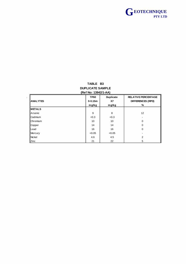
G EOTECHNIQUE PTY LTD
. TP60 Duplicate RELATIVE PERCENTAGE
ANALYTES 0-0.15m X7 DIFFERENCES (RPD)
mg/kg mg/kg %
METALS
Arsenic 9 8 12
Cadmium <0.3 <0.3 -
Chromium 10 10 0
Copper 14 14 0
Lead 16 16 0
Mercury <0.05 <0.05 -
Nickel 4.6 4.5 2
Zinc 21 22 5
TABLE B3
DUPLICATE SAMPLE
(Ref No: 13942/1-AA)
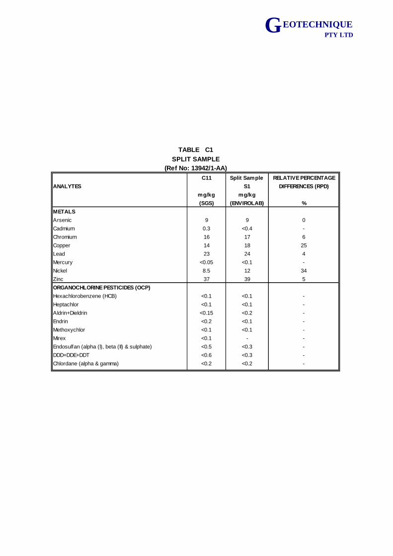
G EOTECHNIQUE PTY LTD
C11 Split Sample RELATIVE PERCENTAGE
ANALYTES S1 DIFFERENCES (RPD)
mg/kg mg/kg
(SGS) (ENVIROLAB) %
METALS
Arsenic 9 9 0
Cadmium 0.3 <0.4 -
Chromium 16 17 6
Copper 14 18 25
Lead 23 24 4
Mercury <0.05 <0.1 -
Nickel 8.5 12 34
Zinc 37 39 5
ORGANOCHLORINE PESTICIDES (OCP)
Hexachlorobenzene (HCB) <0.1 <0.1 -
Heptachlor <0.1 <0.1 -
Aldrin+Dieldrin <0.15 <0.2 -
Endrin <0.2 <0.1 -
Methoxychlor <0.1 <0.1 -
Mirex <0.1 - -
Endosulfan (alpha (I), beta (II) & sulphate) <0.5 <0.3 -
DDD+DDE+DDT <0.6 <0.3 -
Chlordane (alpha & gamma) <0.2 <0.2 -
TABLE C1
SPLIT SAMPLE
(Ref No: 13942/1-AA)
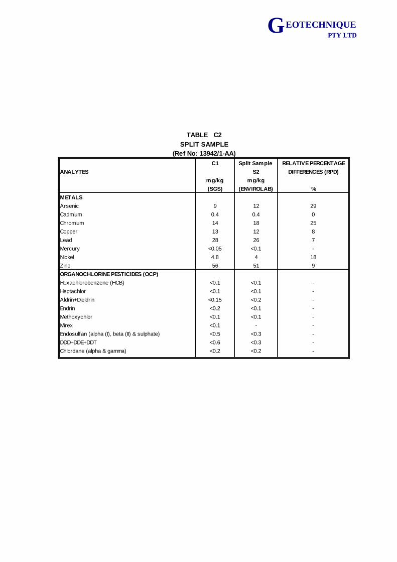
G EOTECHNIQUE PTY LTD
C1 Split Sample RELATIVE PERCENTAGE
ANALYTES S2 DIFFERENCES (RPD)
mg/kg mg/kg
(SGS) (ENVIROLAB) %
METALS
Arsenic 9 12 29
Cadmium 0.4 0.4 0
Chromium 14 18 25
Copper 13 12 8
Lead 28 26 7
Mercury <0.05 <0.1 -
Nickel 4.8 4 18
Zinc 56 51 9
ORGANOCHLORINE PESTICIDES (OCP)
Hexachlorobenzene (HCB) <0.1 <0.1 -
Heptachlor <0.1 <0.1 -
Aldrin+Dieldrin <0.15 <0.2 -
Endrin <0.2 <0.1 -
Methoxychlor <0.1 <0.1 -
Mirex <0.1 - -
Endosulfan (alpha (I), beta (II) & sulphate) <0.5 <0.3 -
DDD+DDE+DDT <0.6 <0.3 -
Chlordane (alpha & gamma) <0.2 <0.2 -
TABLE C2
SPLIT SAMPLE
(Ref No: 13942/1-AA)
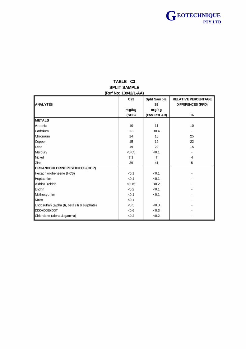
G EOTECHNIQUE PTY LTD
C23 Split Sample RELATIVE PERCENTAGE
ANALYTES S3 DIFFERENCES (RPD)
mg/kg mg/kg
(SGS) (ENVIROLAB) %
METALS
Arsenic 10 11 10
Cadmium 0.3 <0.4 -
Chromium 14 18 25
Copper 15 12 22
Lead 19 22 15
Mercury <0.05 <0.1 -
Nickel 7.3 7 4
Zinc 39 41 5
ORGANOCHLORINE PESTICIDES (OCP)
Hexachlorobenzene (HCB) <0.1 <0.1 -
Heptachlor <0.1 <0.1 -
Aldrin+Dieldrin <0.15 <0.2 -
Endrin <0.2 <0.1 -
Methoxychlor <0.1 <0.1 -
Mirex <0.1 - -
Endosulfan (alpha (I), beta (II) & sulphate) <0.5 <0.3 -
DDD+DDE+DDT <0.6 <0.3 -
Chlordane (alpha & gamma) <0.2 <0.2 -
TABLE C3
SPLIT SAMPLE
(Ref No: 13942/1-AA)
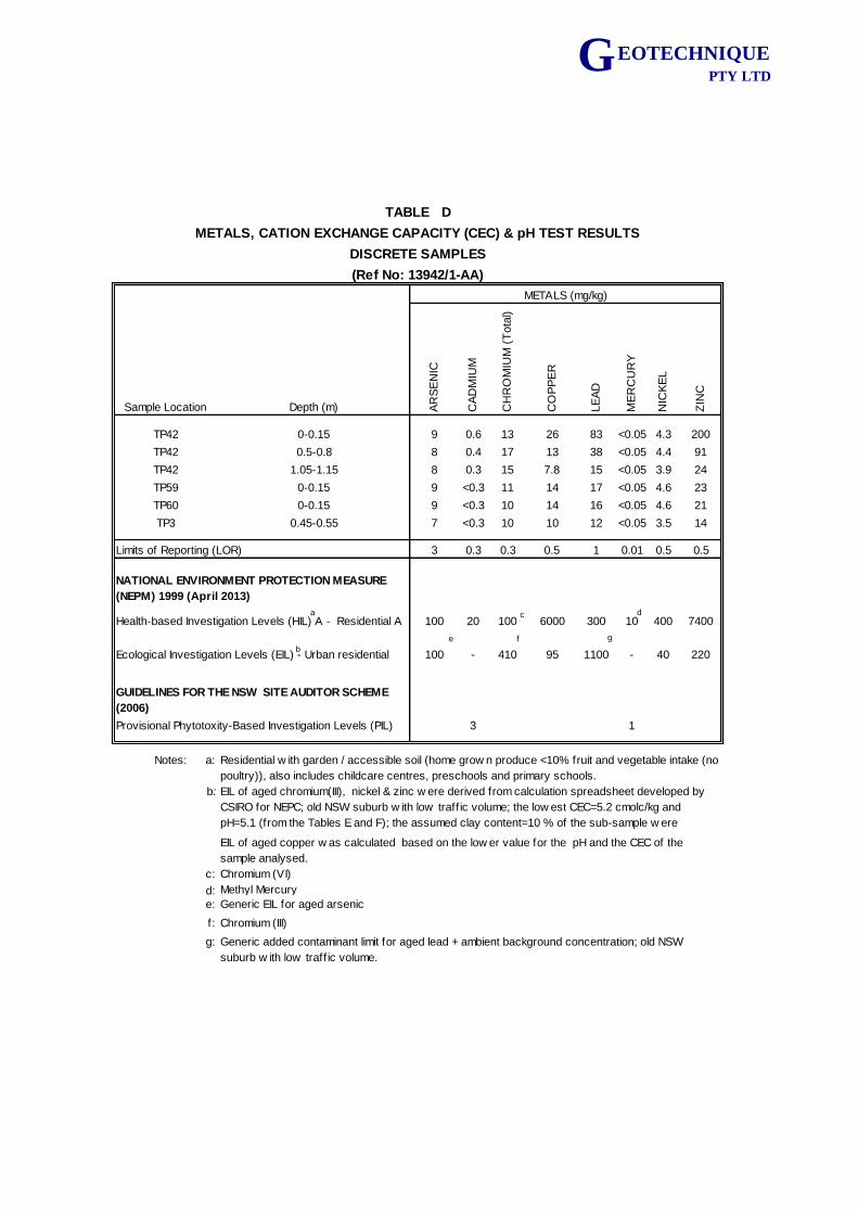
G EOTECHNIQUE PTY LTD
Sample Location Depth (m) AR
SE
NIC
CA
DM
IUM
CH
RO
MIU
M (
Tota
l)
CO
PP
ER
LE
AD
ME
RC
UR
Y
NIC
KE
L
ZIN
C
TP42 0-0.15 9 0.6 13 26 83 <0.05 4.3 200
TP42 0.5-0.8 8 0.4 17 13 38 <0.05 4.4 91
TP42 1.05-1.15 8 0.3 15 7.8 15 <0.05 3.9 24
TP59 0-0.15 9 <0.3 11 14 17 <0.05 4.6 23
TP60 0-0.15 9 <0.3 10 14 16 <0.05 4.6 21
TP3 0.45-0.55 7 <0.3 10 10 12 <0.05 3.5 14
Limits of Reporting (LOR) 3 0.3 0.3 0.5 1 0.01 0.5 0.5
100 20 100 6000 300 10 400 7400
100 - 410 95 1100 - 40 220
3 1
Notes: a:
b:
c: Chromium (VI)
d: Methyl Mercury
e: Generic EIL for aged arsenic
f:
g:
TABLE D
Chromium (III)
Residential w ith garden / accessible soil (home grow n produce <10% fruit and vegetable intake (no
poultry)), also includes childcare centres, preschools and primary schools.
METALS (mg/kg)
Health-based Investigation Levels (HIL) A - Residential A
Ecological Investigation Levels (EIL) - Urban residential
GUIDELINES FOR THE NSW SITE AUDITOR SCHEME
(2006)
Provisional Phytotoxity-Based Investigation Levels (PIL)
NATIONAL ENVIRONMENT PROTECTION MEASURE
(NEPM) 1999 (April 2013)
EIL of aged chromium(III), nickel & zinc w ere derived from calculation spreadsheet developed by
CSIRO for NEPC; old NSW suburb w ith low traff ic volume; the low est CEC=5.2 cmolc/kg and
pH=5.1 (from the Tables E and F); the assumed clay content=10 % of the sub-sample w ere
selected for derivation of EIL; a conservative approach.
Generic added contaminant limit for aged lead + ambient background concentration; old NSW
suburb w ith low traff ic volume.
EIL of aged copper w as calculated based on the low er value for the pH and the CEC of the
sample analysed.
(Ref No: 13942/1-AA)
DISCRETE SAMPLES
METALS, CATION EXCHANGE CAPACITY (CEC) & pH TEST RESULTS
dca
e gf
b
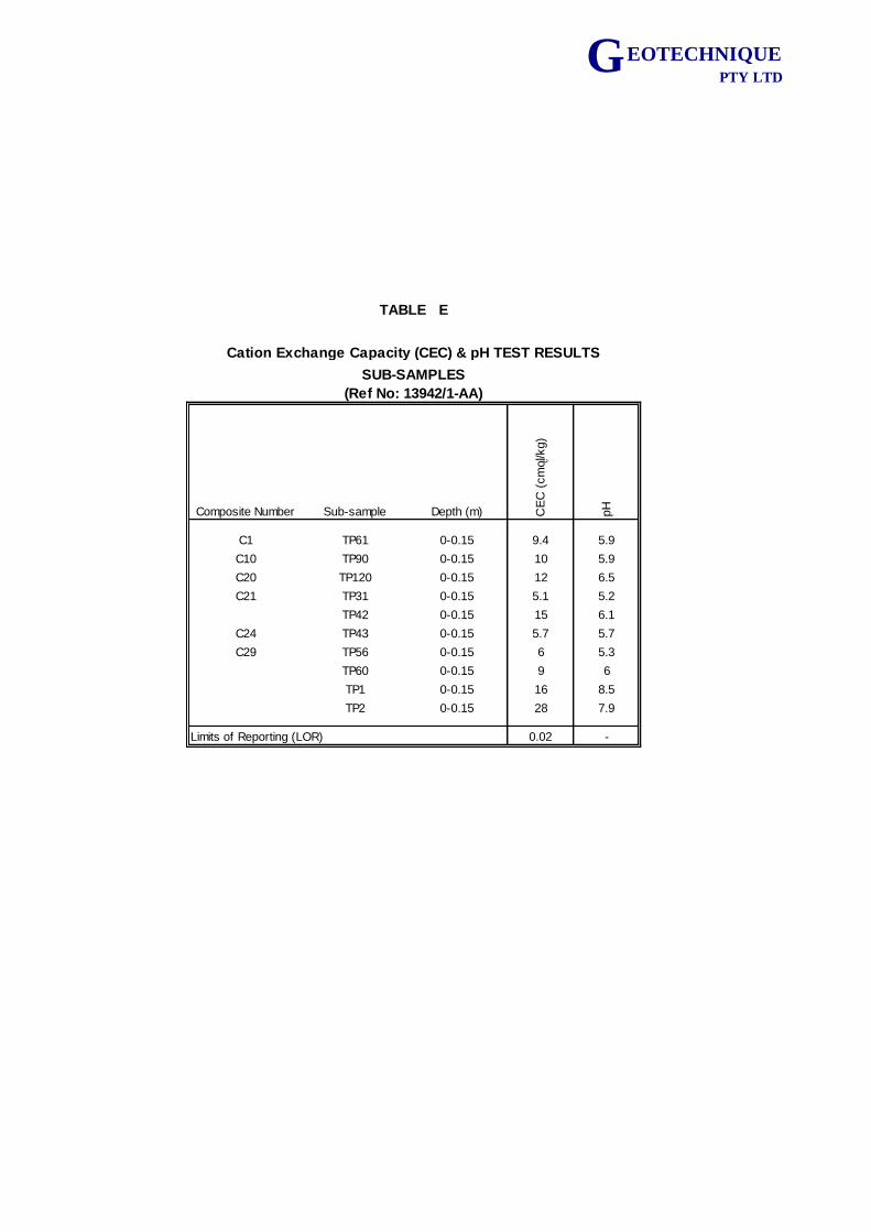
G EOTECHNIQUE PTY LTD
Composite Number Sub-sample Depth (m) CE
C (
cm
ol c/kg)
pH
C1 TP61 0-0.15 9.4 5.9
C10 TP90 0-0.15 10 5.9
C20 TP120 0-0.15 12 6.5
C21 TP31 0-0.15 5.1 5.2
TP42 0-0.15 15 6.1
C24 TP43 0-0.15 5.7 5.7
C29 TP56 0-0.15 6 5.3
TP60 0-0.15 9 6
TP1 0-0.15 16 8.5
TP2 0-0.15 28 7.9
0.02 -Limits of Reporting (LOR)
TABLE E
Cation Exchange Capacity (CEC) & pH TEST RESULTS
SUB-SAMPLES
(Ref No: 13942/1-AA)
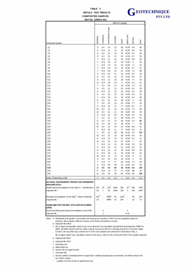
G EOTECHNIQUE PTY LTD
Composite Number A
RS
EN
IC
CA
DM
IUM
CH
RO
MIU
M (
Tota
l)
CO
PP
ER
LE
AD
ME
RC
UR
Y
NIC
KE
L
ZIN
C
C1 9 0.4 14 13 28 <0.05 4.8 56
C2 8 <0.3 11 12 19 <0.05 4.8 28
C3 9 0.3 14 13 22 <0.05 5.2 36
C4 9 0.3 13 12 20 <0.05 4.7 29
C5 7 <0.3 11 10 18 <0.05 5.8 30
C6 7 <0.3 10 13 18 <0.05 6 30
C7 7 <0.3 7.9 12 16 <0.05 6 31
C8 7 <0.3 9.5 13 16 <0.05 5.7 27
C9 7 <0.3 9.9 15 21 <0.05 7.4 38
C10 5 <0.3 8.2 17 16 <0.05 8.2 44
C11 9 0.3 16 14 23 <0.05 8.5 37
C12 8 <0.3 11 16 19 <0.05 8 42
C13 <3 <0.3 3.9 3.3 5 <0.05 2.1 12
C14 7 0.3 18 12 19 <0.05 7.2 31
C15 9 0.3 11 11 20 <0.05 5.3 18
C16 8 <0.3 13 13 20 <0.05 5.2 28
C17 9 0.3 16 12 30 <0.05 6.2 31
C18 7 <0.3 10 13 18 <0.05 5.4 28
C19 9 0.3 12 16 18 <0.05 5 32
C20 7 0.4 13 14 23 <0.05 7.7 42
C21 8 <0.3 13 11 17 <0.05 6.1 27
C22 10 0.3 14 15 19 <0.05 7.3 39
C23 12 0.4 16 11 20 <0.05 4.6 29
C24 8 <0.3 12 9.5 22 <0.05 5.5 31
C25 7 0.3 11 11 39 <0.05 4.4 61
C26 8 0.3 12 14 36 <0.05 4.4 82
C27 11 0.4 16 12 18 <0.05 7 36
C28 10 0.3 14 10 22 <0.05 5.8 31
C29 7 <0.3 10 11 17 <0.05 4.5 21
C30 7 0.5 14 28 98 <0.05 7.6 170
C31 10 0.3 12 14 28 <0.05 5.4 43
C32 9 <0.3 13 13 21 <0.05 6.1 31
C33 15 0.3 15 14 22 <0.05 7 42
C34 7 <0.3 11 13 20 <0.05 7.8 35
C35 9 <0.3 15 13 21 <0.05 9.3 37
C36 8 <0.3 14 11 18 <0.05 6.8 32
C37 9 <0.3 16 11 19 <0.05 5.6 22
C38 10 <0.3 14 14 21 <0.05 6 27
C39 8 0.3 16 9.4 18 <0.05 6 24
C40* 7 <0.3 11 17 20 <0.05 7.4 63
C41 5 <0.3 8.5 9.9 31 <0.05 5.2 34
C42 6 0.6 18 60 42 <0.05 5.6 140
C43 4 <0.3 7.3 27 17 <0.05 14 42
C44 11 0.5 16 30 60 <0.05 9.5 130
3 0.3 0.3 0.5 1 0.01 0.5 0.5
100 20 100 6000 300 10 400 7400
33 7 33 2000 100 3 133 2467
100 - #REF! 95 1100 - 40 220
33 - #REF! 32 367 - 13 73
3 1
Adjusted PIL e 1 0.33
Notes: a:
b: Adjusted HIL=HIL/3
c:
EIL of aged copper w as calculated based on the low er value for the pH and the CEC of the sample analysed.
d: Adjusted EIL=EIL/3
e:
f: Chromium (VI)
g: Methyl Mercury
h:
i:
j:
* samples from the vicnity of abandoned cars
TABLE F
Adjusted HIL b
Limits of Reporting (LOR)
NATIONAL ENVIRONMENT PROTECTION AMENDMENT
MEASURE (2013)
Health-based Investigation Levels (HIL) A - Residential A
METALS TEST RESULTS
COMPOSITED SAMPLES
(Ref No: 13942/1-AA)
METALS (mg/kg)
Ecological Investigation Levels (EIL) - Urban residential
Adjusted EIL d
GUIDELINES FOR THE NSW SITE AUDITOR SCHEME
(2006)
Provisional Phytotoxity-Based Investigation Levels (PIL)
Adjusted PIL=PIL/3
Generic EIL for aged arsenic
Chromium (III)
Residential w ith garden / accessible soil (home grow n produce <10% fruit and vegetable intake (no
poultry)), also includes childcare centres, preschools and primary schools.
Generic added contaminant limit for aged lead + ambient background concentration; old NSW suburb w ith
low traff ic volume.
EIL of aged chromium(III), nickel & zinc w ere derived from calculation spreadsheet developed by CSIRO for
NEPC; old NSW suburb w ith low traff ic volume; the low est CEC=5.2 cmolc/kg and pH=5.1 (from the Tables
E and F); the assumed clay content=10 % of the sub-sample w ere selected for derivation of EIL; a
conservative approach.
g
a
f
h 1ic
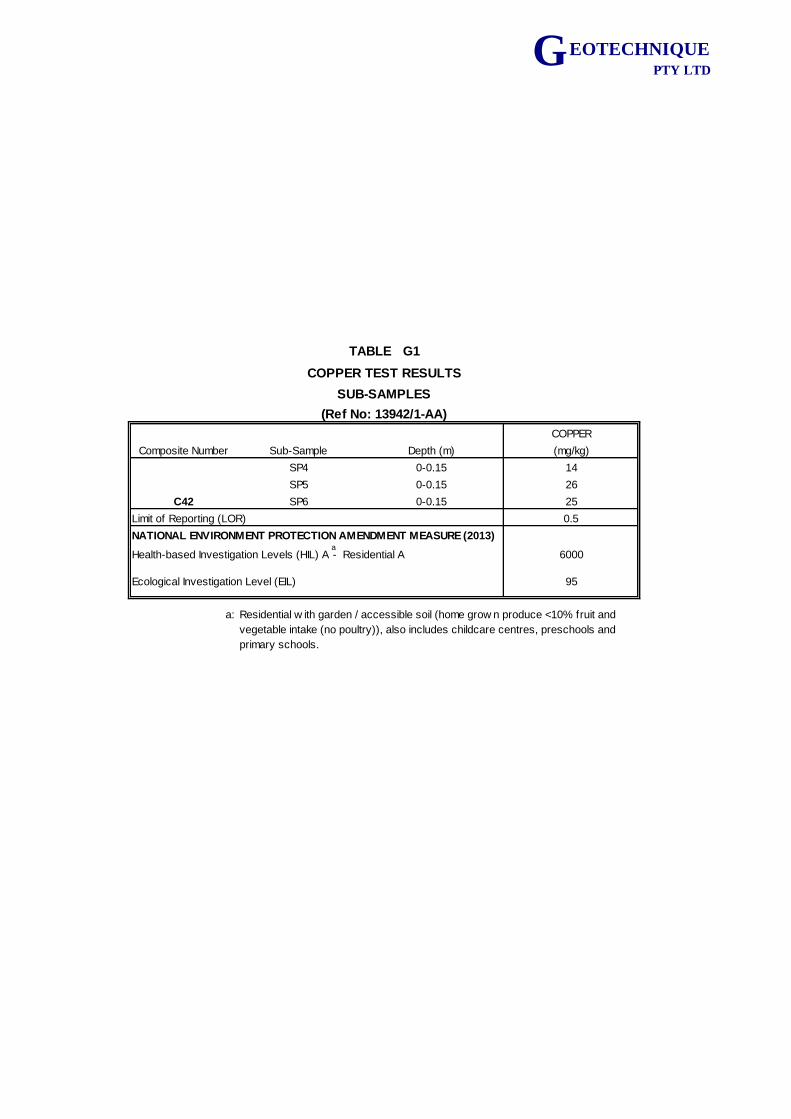
G EOTECHNIQUE PTY LTD
COPPER
Composite Number Sub-Sample Depth (m) (mg/kg)
SP4 0-0.15 14
SP5 0-0.15 26
C42 SP6 0-0.15 25
0.5
6000
95
a:
Limit of Reporting (LOR)
TABLE G1
COPPER TEST RESULTS
SUB-SAMPLES
(Ref No: 13942/1-AA)
NATIONAL ENVIRONMENT PROTECTION AMENDMENT MEASURE (2013)
Health-based Investigation Levels (HIL) A - Residential A
Ecological Investigation Level (EIL)
Residential w ith garden / accessible soil (home grow n produce <10% fruit and
vegetable intake (no poultry)), also includes childcare centres, preschools and
primary schools.
a
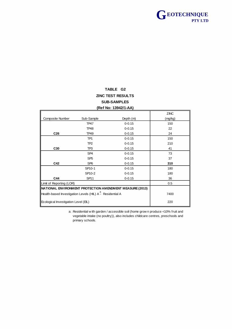
G EOTECHNIQUE PTY LTD
ZINC
Composite Number Sub-Sample Depth (m) (mg/kg)
TP47 0-0.15 150
TP48 0-0.15 22
C26 TP49 0-0.15 24
TP1 0-0.15 150
TP2 0-0.15 210
C30 TP3 0-0.15 41
SP4 0-0.15 73
SP5 0-0.15 37
C42 SP6 0-0.15 310
SP10-1 0-0.15 180
SP10-2 0-0.15 180
C44 SP11 0-0.15 36
0.5
7400
220
a:
TABLE G2
ZINC TEST RESULTS
SUB-SAMPLES
(Ref No: 13942/1-AA)
Residential w ith garden / accessible soil (home grow n produce <10% fruit and
vegetable intake (no poultry)), also includes childcare centres, preschools and
primary schools.
Limit of Reporting (LOR)
NATIONAL ENVIRONMENT PROTECTION AMENDMENT MEASURE (2013)
Ecological Investigation Level (EIL)
Health-based Investigation Levels (HIL) A - Residential Aa
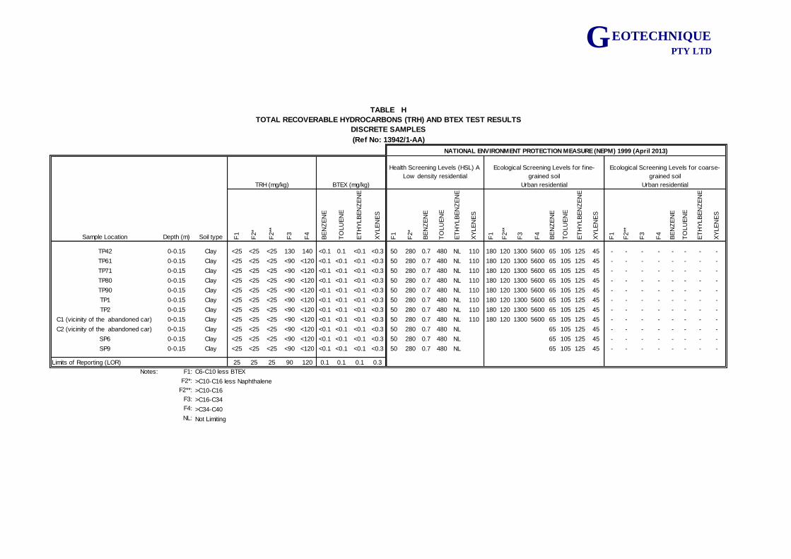
G EOTECHNIQUE PTY LTD
Sample Location Depth (m) Soil type F1
F2*
F2**
F3
F4
BE
NZ
EN
E
TO
LU
EN
E
ET
HY
LB
EN
ZE
NE
XY
LE
NE
S
F1
F2*
BE
NZ
EN
E
TO
LU
EN
E
ET
HY
LB
EN
ZE
NE
XY
LE
NE
S
F1
F2**
F3
F4
BE
NZ
EN
E
TO
LU
EN
E
ET
HY
LB
EN
ZE
NE
XY
LE
NE
S
F1
F2**
F3
F4
BE
NZ
EN
E
TO
LU
EN
E
ET
HY
LB
EN
ZE
NE
XY
LE
NE
S
TP42 0-0.15 Clay <25 <25 <25 130 140 <0.1 0.1 <0.1 <0.3 50 280 0.7 480 NL 110 180 120 1300 5600 65 105 125 45 - - - - - - - -
TP61 0-0.15 Clay <25 <25 <25 <90 <120 <0.1 <0.1 <0.1 <0.3 50 280 0.7 480 NL 110 180 120 1300 5600 65 105 125 45 - - - - - - - -
TP71 0-0.15 Clay <25 <25 <25 <90 <120 <0.1 <0.1 <0.1 <0.3 50 280 0.7 480 NL 110 180 120 1300 5600 65 105 125 45 - - - - - - - -
TP80 0-0.15 Clay <25 <25 <25 <90 <120 <0.1 <0.1 <0.1 <0.3 50 280 0.7 480 NL 110 180 120 1300 5600 65 105 125 45 - - - - - - - -
TP90 0-0.15 Clay <25 <25 <25 <90 <120 <0.1 <0.1 <0.1 <0.3 50 280 0.7 480 NL 110 180 120 1300 5600 65 105 125 45 - - - - - - - -
TP1 0-0.15 Clay <25 <25 <25 <90 <120 <0.1 <0.1 <0.1 <0.3 50 280 0.7 480 NL 110 180 120 1300 5600 65 105 125 45 - - - - - - - -
TP2 0-0.15 Clay <25 <25 <25 <90 <120 <0.1 <0.1 <0.1 <0.3 50 280 0.7 480 NL 110 180 120 1300 5600 65 105 125 45 - - - - - - - -
C1 (vicinity of the abandoned car) 0-0.15 Clay <25 <25 <25 <90 <120 <0.1 <0.1 <0.1 <0.3 50 280 0.7 480 NL 110 180 120 1300 5600 65 105 125 45 - - - - - - - -
C2 (vicinity of the abandoned car) 0-0.15 Clay <25 <25 <25 <90 <120 <0.1 <0.1 <0.1 <0.3 50 280 0.7 480 NL 65 105 125 45 - - - - - - - -
SP6 0-0.15 Clay <25 <25 <25 <90 <120 <0.1 <0.1 <0.1 <0.3 50 280 0.7 480 NL 65 105 125 45 - - - - - - - -
SP9 0-0.15 Clay <25 <25 <25 <90 <120 <0.1 <0.1 <0.1 <0.3 50 280 0.7 480 NL 65 105 125 45 - - - - - - - -
25 25 25 90 120 0.1 0.1 0.1 0.3
Notes: F1:
F2*:
F2**: >C10-C16
F3: >C16-C34
F4: >C34-C40
NL: Not Limiting
TABLE H
DISCRETE SAMPLES
(Ref No: 13942/1-AA)
Ecological Screening Levels for coarse-
grained soil
Urban residentialTRH (mg/kg) BTEX (mg/kg)
NATIONAL ENVIRONMENT PROTECTION MEASURE (NEPM) 1999 (April 2013)
>C10-C16 less Naphthalene
Limits of Reporting (LOR)
Health Screening Levels (HSL) A
Low density residential
Ecological Screening Levels for f ine-
grained soil
Urban residential
TOTAL RECOVERABLE HYDROCARBONS (TRH) AND BTEX TEST RESULTS
C6-C10 less BTEX
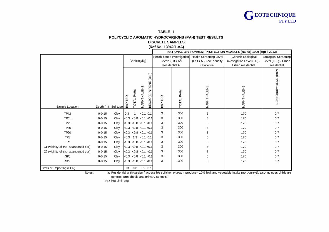
G EOTECHNIQUE PTY LTD
Health Screening Level
(HSL) A - Low density
residential
Generic Ecological
Investigation Level (EIL) -
Urban residential
Ecological Screening
Level (ESL) - Urban
residential
Sample Location Depth (m) Soil type BaP
TE
Q
TO
TA
L P
AH
s
NA
PH
TH
ALE
NE
BE
NZ
O(a
)PY
RE
NE
(B
aP
)
BaP
TE
Q
TO
TA
L P
AH
s
NA
PH
TH
ALE
NE
NA
PH
TH
ALE
NE
BE
NZ
O(a
)PY
RE
NE
(B
aP
)
TP42 0-0.15 Clay 0.3 1 <0.1 0.1 3 300 5 170 0.7
TP61 0-0.15 Clay <0.3 <0.8 <0.1 <0.1 3 300 5 170 0.7
TP71 0-0.15 Clay <0.3 <0.8 <0.1 <0.1 3 300 5 170 0.7
TP80 0-0.15 Clay <0.3 <0.8 <0.1 <0.1 3 300 5 170 0.7
TP90 0-0.15 Clay <0.3 <0.8 <0.1 <0.1 3 300 5 170 0.7
TP1 0-0.15 Clay <0.3 1.3 <0.1 0.1 3 300 5 170 0.7
TP2 0-0.15 Clay <0.3 <0.8 <0.1 <0.1 3 300 5 170 0.7
C1 (vicinity of the abandoned car) 0-0.15 Clay <0.3 <0.8 <0.1 <0.1 3 300 5 170 0.7
C2 (vicinity of the abandoned car) 0-0.15 Clay <0.3 <0.8 <0.1 <0.1 3 300 5 170 0.7
SP6 0-0.15 Clay <0.3 <0.8 <0.1 <0.1 3 300 5 170 0.7
SP9 0-0.15 Clay <0.3 <0.8 <0.1 <0.1 3 300 5 170 0.7
0.3 0.8 0.1 0.1
Notes: a:
NL: Not Limimting
NATIONAL ENVIRONMENT PROTECTION MEASURE (NEPM) 1999 (April 2013)
Limits of Reporting (LOR)
Residential w ith garden / accessible soil (home grow n produce <10% fruit and vegetable intake (no poultry)), also includes childcare
centres, preschools and primary schools.
TABLE I
POLYCYCLIC AROMATIC HYDROCARBONS (PAH) TEST RESULTS
DISCRETE SAMPLES
(Ref No: 13942/1-AA)
PAH (mg/kg)
Health-based Investigation
Levels (HIL) A -
Residential A
a
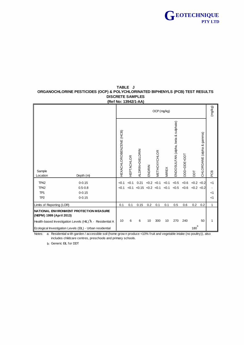
G EOTECHNIQUE PTY LTD
(mg/k
g)
Sample
Location Depth (m) HE
XA
CH
LO
RO
BE
NZ
EN
E (
HC
B)
HE
PT
AC
HLO
R
ALD
RIN
+D
IELD
RIN
EN
DR
IN
ME
TH
OX
YC
HLO
R
MIR
EX
EN
DO
SU
LF
AN
(alp
ha, beta
& s
ulp
hate
)
DD
D+D
DE
+D
DT
DD
T
CH
LO
RD
AN
E (
alp
ha &
gam
ma)
PC
B
TP42 0-0.15 <0.1 <0.1 0.21 <0.2 <0.1 <0.1 <0.5 <0.6 <0.2 <0.2 <1
TP42 0.5-0.8 <0.1 <0.1 <0.15 <0.2 <0.1 <0.1 <0.5 <0.6 <0.2 <0.2 -
TP1 0-0.15 <1
TP2 0-0.15 <1
0.1 0.1 0.15 0.2 0.1 0.1 0.5 0.6 0.2 0.2 1
10 6 6 10 300 10 270 240 50 1
180
Notes: a:
b: Generic EIL for DDT
Ecological Investigation Levels (EIL) - Urban residential
TABLE J
(Ref No: 13942/1-AA)
OCP (mg/kg)
Health-based Investigation Levels (HIL) A - Residential A
Limits of Reporting (LOR)
NATIONAL ENVIRONMENT PROTECTION MEASURE
(NEPM) 1999 (April 2013)
DISCRETE SAMPLES
ORGANOCHLORINE PESTICIDES (OCP) & POLYCHLORINATED BIPHENYLS (PCB) TEST RESULTS
Residential w ith garden / accessible soil (home grow n produce <10% fruit and vegetable intake (no poultry)), also
includes childcare centres, preschools and primary schools.
a
b
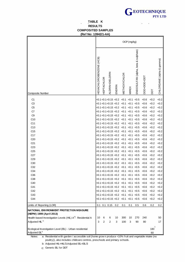
G EOTECHNIQUE PTY LTD
Composite Number HE
XA
CH
LO
RO
BE
NZ
EN
E (
HC
B)
HE
PT
AC
HLO
R
ALD
RIN
+D
IELD
RIN
EN
DR
IN
ME
TH
OX
YC
HLO
R
MIR
EX
EN
DO
SU
LF
AN
(alp
ha, beta
& s
ulp
hate
)
DD
D+D
DE
+D
DT
DD
T
CH
LO
RD
AN
E (
alp
ha &
gam
ma)
C1 <0.1 <0.1<0.15 <0.2 <0.1 <0.1 <0.5 <0.6 <0.2 <0.2
C3 <0.1 <0.1<0.15 <0.2 <0.1 <0.1 <0.5 <0.6 <0.2 <0.2
C5 <0.1 <0.1<0.15 <0.2 <0.1 <0.1 <0.5 <0.6 <0.2 <0.2
C7 <0.1 <0.1<0.15 <0.2 <0.1 <0.1 <0.5 <0.6 <0.2 <0.2
C9 <0.1 <0.1<0.15 <0.2 <0.1 <0.1 <0.5 <0.6 <0.2 <0.2
C10 <0.1 <0.1<0.15 <0.2 <0.1 <0.1 <0.5 <0.6 <0.2 <0.2
C11 <0.1 <0.1<0.15 <0.2 <0.1 <0.1 <0.5 <0.6 <0.2 <0.2
C13 <0.1 <0.1<0.15 <0.2 <0.1 <0.1 <0.5 <0.6 <0.2 <0.2
C15 <0.1 <0.1<0.15 <0.2 <0.1 <0.1 <0.5 <0.6 <0.2 <0.2
C17 <0.1 <0.1<0.15 <0.2 <0.1 <0.1 <0.5 <0.6 <0.2 <0.2
C20 <0.1 <0.1<0.15 <0.2 <0.1 <0.1 <0.5 <0.6 <0.2 <0.2
C21 <0.1 <0.1<0.15 <0.2 <0.1 <0.1 <0.5 <0.6 <0.2 <0.2
C23 <0.1 <0.1<0.15 <0.2 <0.1 <0.1 <0.5 <0.6 <0.2 <0.2
C25 <0.1 <0.1<0.15 <0.2 <0.1 <0.1 <0.5 <0.6 <0.2 <0.2
C27 <0.1 <0.1<0.15 <0.2 <0.1 <0.1 <0.5 <0.6 <0.2 <0.2
C29 <0.1 <0.1<0.15 <0.2 <0.1 <0.1 <0.5 <0.6 <0.2 <0.2
C30 <0.1 <0.1<0.15 <0.2 <0.1 <0.1 <0.5 <0.6 <0.2 <0.2
C32 <0.1 <0.1<0.15 <0.2 <0.1 <0.1 <0.5 <0.6 <0.2 <0.2
C34 <0.1 <0.1<0.15 <0.2 <0.1 <0.1 <0.5 <0.6 <0.2 <0.2
C36 <0.1 <0.1<0.15 <0.2 <0.1 <0.1 <0.5 <0.6 <0.2 <0.2
C38 <0.1 <0.1<0.15 <0.2 <0.1 <0.1 <0.5 <0.6 <0.2 <0.2
C40 <0.1 <0.1<0.15 <0.2 <0.1 <0.1 <0.5 <0.6 <0.2 <0.2
C41 <0.1 <0.1<0.15 <0.2 <0.1 <0.1 <0.5 <0.6 <0.2 <0.2
C42 <0.1 <0.1<0.15 <0.2 <0.1 <0.1 <0.5 <0.6 <0.2 <0.2
C43 <0.1 <0.1<0.15 <0.2 <0.1 <0.1 <0.5 <0.6 <0.2 <0.2
C44 <0.1 <0.1<0.15 <0.2 <0.1 <0.1 <0.5 <0.6 <0.2 <0.2
Limits of Reporting (LOR) 0.1 0.1 0.15 0.2 0.1 0.1 0.5 0.6 0.2 0.2
Health-based Investigation Levels (HIL) A - Residential A 10 6 6 10 300 10 270 240 50
Adjusted HIL b 3 2 2 3 100 3 90 80 17
Ecological Investigation Level (EIL) - Urban residential 180
Adjusted EILb60
Notes: a:
b: Adjusted HIL=HIL/3;Adjusted EIL=EIL/3
c: Generic EIL for DDT
OCP (mg/kg)
ORGANOCHLORINE PESTICIDES (OCP) & POLYCHLORINATED BIPHENYLS (PCB) TEST
RESULTS
TABLE K
COMPOSITED SAMPLES
(Ref No: 13942/1-AA)
NATIONAL ENVIRONMENT PROTECTION MEASURE
(NEPM) 1999 (April 2013)
Residential w ith garden / accessible soil (home grow n produce <10% fruit and vegetable intake (no
poultry)), also includes childcare centres, preschools and primary schools.
a
c
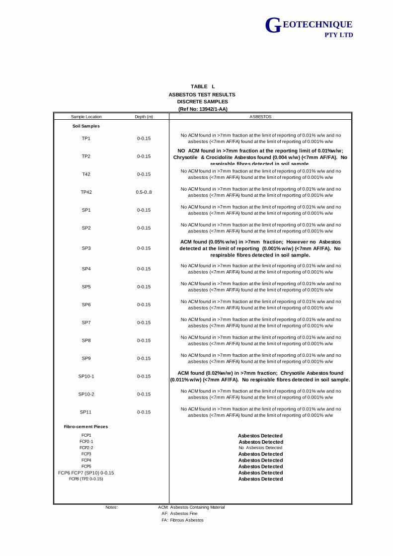
G EOTECHNIQUE PTY LTD
Sample Location Depth (m) ASBESTOS
Soil Samples
TP1 0-0.15 No ACM found in >7mm fraction at the limit of reporting of 0.01% w/w and no
asbestos (<7mm AF/FA) found at the limit of reporting of 0.001% w/w
TP2 0-0.15NO ACM found in >7mm fraction at the reporting limit of 0.01%w/w;
Chrysotile & Crocidolite Asbestos found (0.004 w/w) (<7mm AF/FA). No
respirable fibres detected in soil sample.
T42 0-0.15 No ACM found in >7mm fraction at the limit of reporting of 0.01% w/w and no
asbestos (<7mm AF/FA) found at the limit of reporting of 0.001% w/w
TP42 0.5-0..8 No ACM found in >7mm fraction at the limit of reporting of 0.01% w/w and no
asbestos (<7mm AF/FA) found at the limit of reporting of 0.001% w/w
SP1 0-0.15 No ACM found in >7mm fraction at the limit of reporting of 0.01% w/w and no
asbestos (<7mm AF/FA) found at the limit of reporting of 0.001% w/w
SP2 0-0.15 No ACM found in >7mm fraction at the limit of reporting of 0.01% w/w and no
asbestos (<7mm AF/FA) found at the limit of reporting of 0.001% w/w
SP3 0-0.15
ACM found (0.05% w/w) in >7mm fraction; However no Asbestos
detected at the limit of reporting (0.001% w/w) (<7mm AF/FA). No
respirable fibres detected in soil sample.
SP4 0-0.15 No ACM found in >7mm fraction at the limit of reporting of 0.01% w/w and no
asbestos (<7mm AF/FA) found at the limit of reporting of 0.001% w/w
SP5 0-0.15 No ACM found in >7mm fraction at the limit of reporting of 0.01% w/w and no
asbestos (<7mm AF/FA) found at the limit of reporting of 0.001% w/w
SP6 0-0.15 No ACM found in >7mm fraction at the limit of reporting of 0.01% w/w and no
asbestos (<7mm AF/FA) found at the limit of reporting of 0.001% w/w
SP7 0-0.15 No ACM found in >7mm fraction at the limit of reporting of 0.01% w/w and no
asbestos (<7mm AF/FA) found at the limit of reporting of 0.001% w/w
SP8 0-0.15 No ACM found in >7mm fraction at the limit of reporting of 0.01% w/w and no
asbestos (<7mm AF/FA) found at the limit of reporting of 0.001% w/w
SP9 0-0.15 No ACM found in >7mm fraction at the limit of reporting of 0.01% w/w and no
asbestos (<7mm AF/FA) found at the limit of reporting of 0.001% w/w
SP10-1 0-0.15ACM found (0.02%w/w) in >7mm fraction; Chrysotile Asbestos found
(0.011% w/w) (<7mm AF/FA). No respirable fibres detected in soil sample.
SP10-2 0-0.15 No ACM found in >7mm fraction at the limit of reporting of 0.01% w/w and no
asbestos (<7mm AF/FA) found at the limit of reporting of 0.001% w/w
SP11 0-0.15 No ACM found in >7mm fraction at the limit of reporting of 0.01% w/w and no
asbestos (<7mm AF/FA) found at the limit of reporting of 0.001% w/w
Fibro-cement Pieces
FCP1 Asbestos DetectedFCP2-1 Asbestos DetectedFCP2-2 No Asbestos Detected
FCP3 Asbestos DetectedFCP4 Asbestos DetectedFCP5 Asbestos Detected
FCP6 FCP7 (SP10) 0-0.15 Asbestos DetectedFCP8 (TP2 0-0.15) Asbestos Detected
Notes: ACM: Asbestos Containing Material
AF: Asbestos Fine
FA: Fibrous Asbestos
TABLE L
ASBESTOS TEST RESULTS
DISCRETE SAMPLES
(Ref No: 13942/1-AA)

APPENDIX A
CADASTRAL MAPS/LAND TILTE INFORMATION
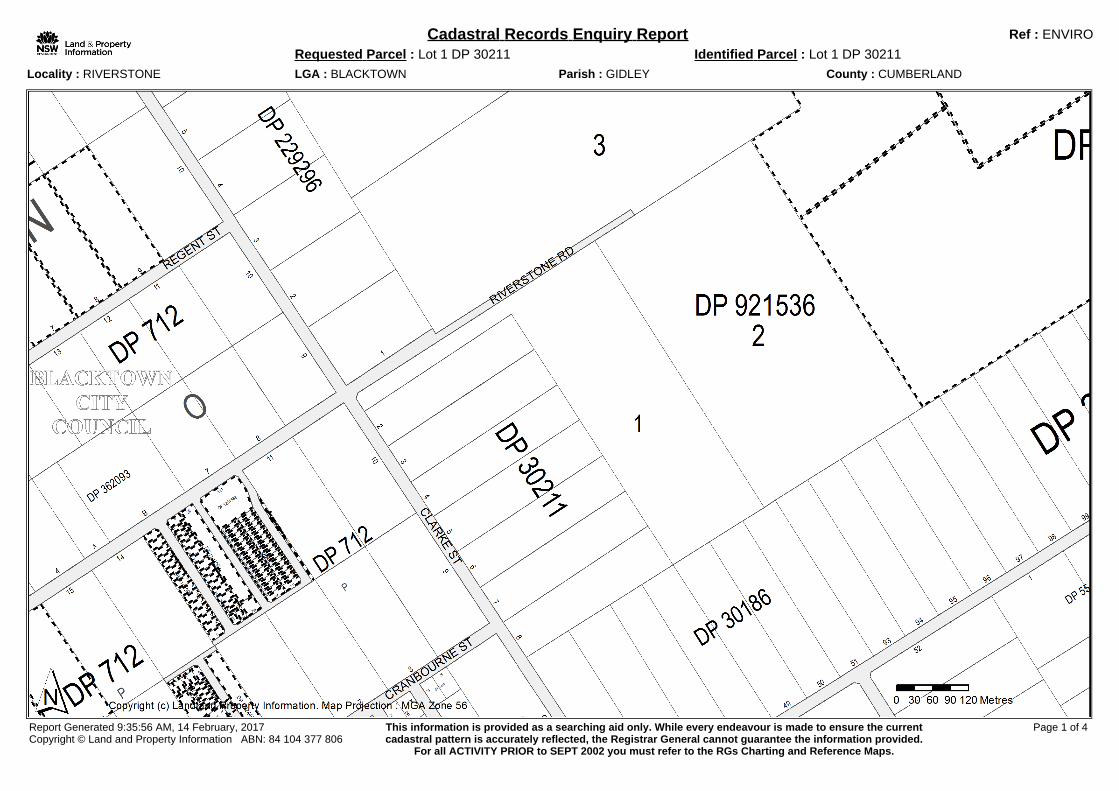
Cadastral Records Enquiry Report Ref : ENVIRO
Requested Parcel : Lot 1 DP 30211 Identified Parcel : Lot 1 DP 30211
Locality : RIVERSTONE LGA : BLACKTOWN Parish : GIDLEY County : CUMBERLAND
Report Generated 9:35:56 AM, 14 February, 2017Copyright © Land and Property Information ABN: 84 104 377 806
This information is provided as a searching aid only. While every endeavour is made to ensure the currentcadastral pattern is accurately reflected, the Registrar General cannot guarantee the information provided.
For all ACTIVITY PRIOR to SEPT 2002 you must refer to the RGs Charting and Reference Maps.
Page 1 of 4
DP712Lot(s): 7, 8, 9 Section : N
DP1224329 REGISTERED SURVEY RESUMPTION OR ACQUISITIONLot(s): 16 Section : P
DP1218224 PRE-ALLOCATED UNAVAILABLE SUBDIVISIONDP1218226 PRE-ALLOCATED UNAVAILABLE SUBDIVISIONDP1218230 PRE-ALLOCATED UNAVAILABLE SUBDIVISION
DP364087Lot(s): B
DP1218224 PRE-ALLOCATED UNAVAILABLE SUBDIVISIONDP1218226 PRE-ALLOCATED UNAVAILABLE SUBDIVISIONDP1218230 PRE-ALLOCATED UNAVAILABLE SUBDIVISION
DP786801Lot(s): 2
DP1199607 REGISTERED SURVEY EASEMENTDP1076228Lot(s): 10
DP579544 HISTORICAL SURVEY SUBDIVISIONDP1035498 REGISTERED COMPILATION ROADS ACT, 1993
DP1097608Lot(s): 91
DP786801 HISTORICAL SURVEY SUBDIVISIONDP1035498 REGISTERED COMPILATION ROADS ACT, 1993DP1076228 REGISTERED SURVEY ROADS ACT, 1993DP1199607 REGISTERED SURVEY EASEMENT
DP1182446Lot(s): 1, 3
DP712 HISTORICAL COMPILATION UNRESEARCHEDNSW GAZ. 26-04-2013 Folio : 1077
ACQUIRED FOR COUNCIL PURPOSESLOTS 1-3 DP1182446
DP1192292Lot(s): 29
DP1220406 WITHDRAWN UNAVAILABLE SUBDIVISIONDP1228355 PRE-ALLOCATED UNAVAILABLE SUBDIVISION
Lot(s): 18, 19, 20, 21, 22, 23, 24, 25, 26DP1211332 REGISTERED SURVEY SUBDIVISION
Lot(s): 1, 2, 3, 4, 5, 6, 7, 8, 9, 10, 11, 12, 13, 14, 15, 16, 18, 19, 20, 21, 22, 23, 24, 25, 26, 29DP712 HISTORICAL COMPILATION UNRESEARCHED
DP1201583Lot(s): 121
DP712 HISTORICAL COMPILATION UNRESEARCHEDDP1208971 REGISTERED SURVEY SUBDIVISIONDP1219627 REGISTERED SURVEY EASEMENT
DP1202214Lot(s): 1701, 1702, 1703
DP712 HISTORICAL COMPILATION UNRESEARCHEDDP1192292 REGISTERED SURVEY SUBDIVISIONDP1211332 REGISTERED SURVEY SUBDIVISION
DP1208971Lot(s): 1236, 1237
DP1226352 PRE-ALLOCATED UNAVAILABLE SUBDIVISIONLot(s): 1221, 1222, 1223, 1224, 1225, 1226, 1227, 1228, 1229, 1230, 1231, 1232, 1233, 1234, 1235, 1236, 1237, 1238, 1239, 1240, 1241,1242, 1243, 1244, 1245, 1246, 1247, 1248, 1249, 1250, 1251, 1252, 1253, 1254
DP712 HISTORICAL COMPILATION UNRESEARCHEDDP1201583 REGISTERED SURVEY SUBDIVISION
DP1211332Lot(s): 205
DP1220406 WITHDRAWN UNAVAILABLE SUBDIVISIONDP1228355 PRE-ALLOCATED UNAVAILABLE SUBDIVISION
Lot(s): 201, 202, 203, 204, 205DP712 HISTORICAL COMPILATION UNRESEARCHEDDP1192292 REGISTERED SURVEY SUBDIVISION
Cadastral Records Enquiry Report Ref : ENVIRO
Requested Parcel : Lot 1 DP 30211 Identified Parcel : Lot 1 DP 30211
Locality : RIVERSTONE LGA : BLACKTOWN Parish : GIDLEY County : CUMBERLANDStatus Surv/Comp Purpose
Caution: For all ACTIVITY PRIOR to SEPT 2002 you must refer to the RGs Charting and Reference Maps.Report Generated 9:35:56 AM, 14 February, 2017Copyright © Land and Property Information ABN: 84 104 377 806
Page 2 of 4
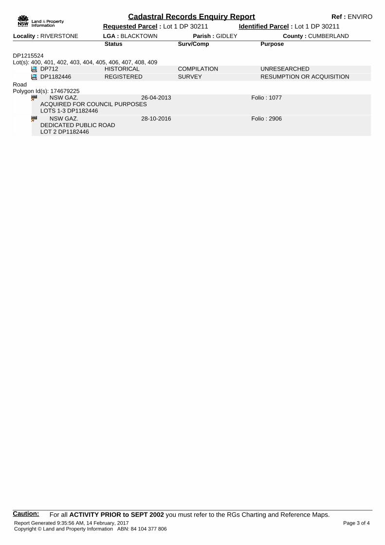
DP1215524Lot(s): 400, 401, 402, 403, 404, 405, 406, 407, 408, 409
DP712 HISTORICAL COMPILATION UNRESEARCHEDDP1182446 REGISTERED SURVEY RESUMPTION OR ACQUISITION
RoadPolygon Id(s): 174679225
NSW GAZ. 26-04-2013 Folio : 1077ACQUIRED FOR COUNCIL PURPOSESLOTS 1-3 DP1182446
NSW GAZ. 28-10-2016 Folio : 2906DEDICATED PUBLIC ROADLOT 2 DP1182446
Cadastral Records Enquiry Report Ref : ENVIRO
Requested Parcel : Lot 1 DP 30211 Identified Parcel : Lot 1 DP 30211
Locality : RIVERSTONE LGA : BLACKTOWN Parish : GIDLEY County : CUMBERLANDStatus Surv/Comp Purpose
Caution: For all ACTIVITY PRIOR to SEPT 2002 you must refer to the RGs Charting and Reference Maps.Report Generated 9:35:56 AM, 14 February, 2017Copyright © Land and Property Information ABN: 84 104 377 806
Page 3 of 4
DP712 COMPILATION UNRESEARCHEDDP1447 SURVEY UNRESEARCHEDDP30186 SURVEY UNRESEARCHEDDP30211 SURVEY UNRESEARCHEDDP208203 SURVEY SUBDIVISIONDP229296 SURVEY SUBDIVISIONDP362093 COMPILATION UNRESEARCHEDDP364087 COMPILATION UNRESEARCHEDDP523552 COMPILATION SUBDIVISIONDP554233 COMPILATION SUBDIVISIONDP786801 SURVEY SUBDIVISIONDP800352 SURVEY CONSOLIDATIONDP908130 COMPILATION UNRESEARCHEDDP921536 COMPILATION UNRESEARCHEDDP1076228 SURVEY ROADS ACT, 1993DP1097608 SURVEY ROADS ACT, 1993DP1182446 SURVEY RESUMPTION OR ACQUISITIONDP1192292 SURVEY SUBDIVISIONDP1192292 UNRESEARCHED SUBDIVISIONDP1201583 UNRESEARCHED SUBDIVISIONDP1201583 SURVEY SUBDIVISIONDP1201583 SURVEY SUBDIVISIONDP1202214 SURVEY SUBDIVISIONDP1202214 UNRESEARCHED SUBDIVISIONDP1208971 SURVEY SUBDIVISIONDP1208971 UNRESEARCHED SUBDIVISIONDP1208971 SURVEY SUBDIVISIONDP1211332 SURVEY SUBDIVISIONDP1211332 UNRESEARCHED SUBDIVISIONDP1215524 UNRESEARCHED SUBDIVISIONDP1215524 SURVEY SUBDIVISION
Cadastral Records Enquiry Report Ref : ENVIRO
Requested Parcel : Lot 1 DP 30211 Identified Parcel : Lot 1 DP 30211
Locality : RIVERSTONE LGA : BLACKTOWN Parish : GIDLEY County : CUMBERLANDPlan Surv/Comp Purpose
blahReport Generated 9:35:56 AM, 14 February, 2017Copyright © Land and Property Information ABN: 84 104 377 806
Page 4 of 4

APPENDIX B
AERIAL PHOTOGRAPHS
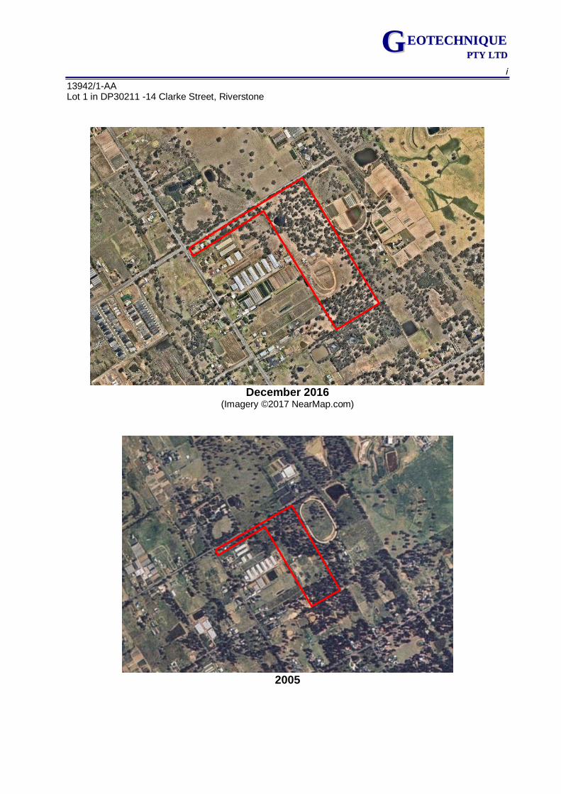
i
13942/1-AA Lot 1 in DP30211 -14 Clarke Street, Riverstone
GG EEOOTTEECCHHNNIIQQUUEE PPTTYY LLTTDD
December 2016
(Imagery ©2017 NearMap.com)
2005
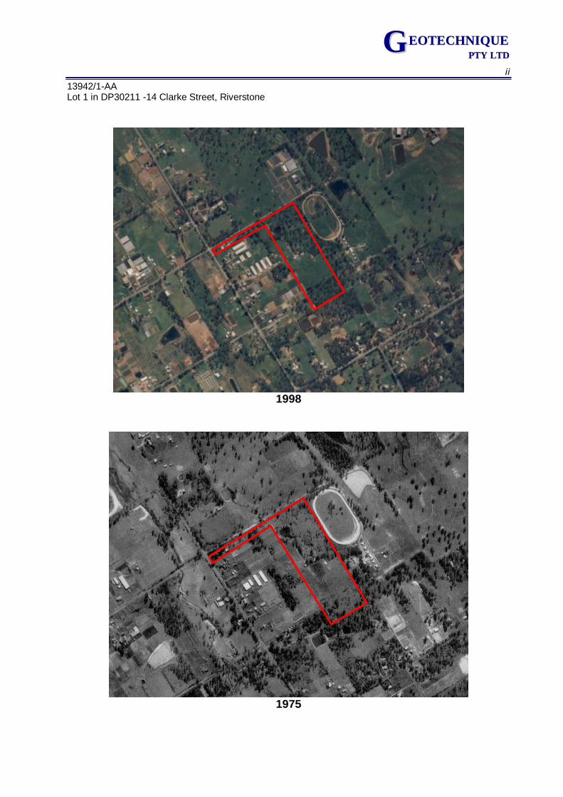
ii
13942/1-AA Lot 1 in DP30211 -14 Clarke Street, Riverstone
GG EEOOTTEECCHHNNIIQQUUEE PPTTYY LLTTDD
1998
1975
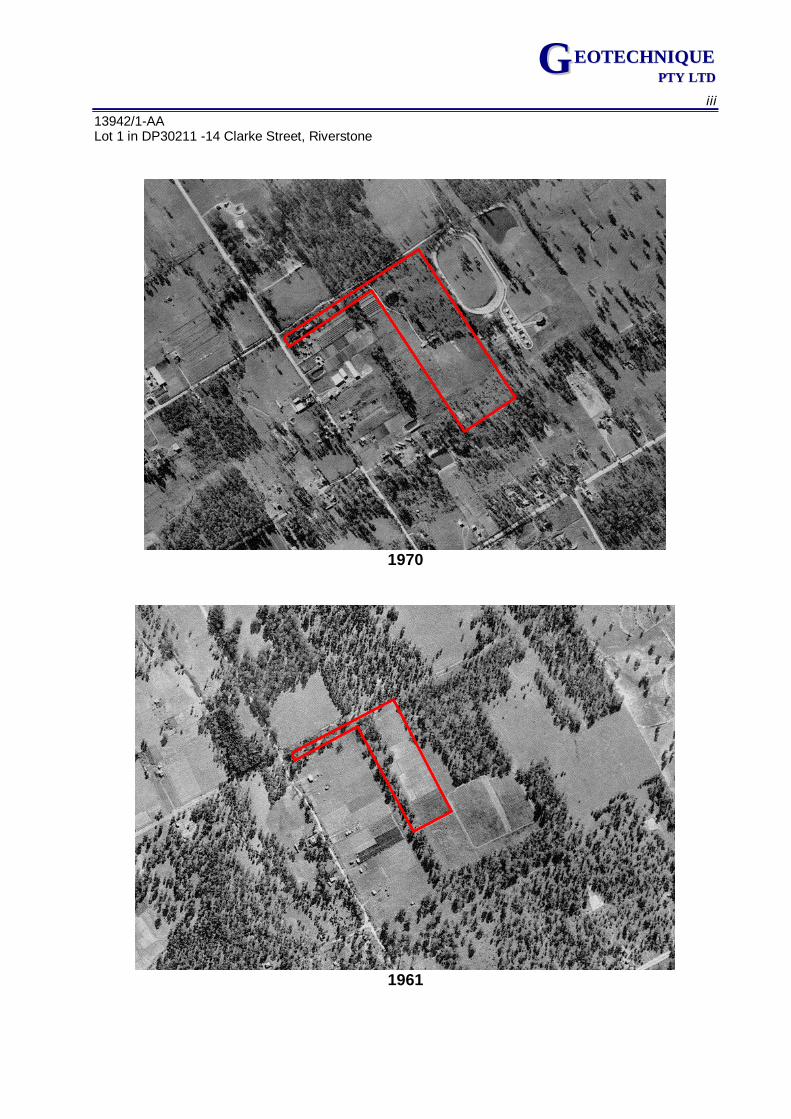
iii
13942/1-AA Lot 1 in DP30211 -14 Clarke Street, Riverstone
GG EEOOTTEECCHHNNIIQQUUEE PPTTYY LLTTDD
1970
1961

APPENDIX C
NSW OEH RECORDS OF EPA NOTICES
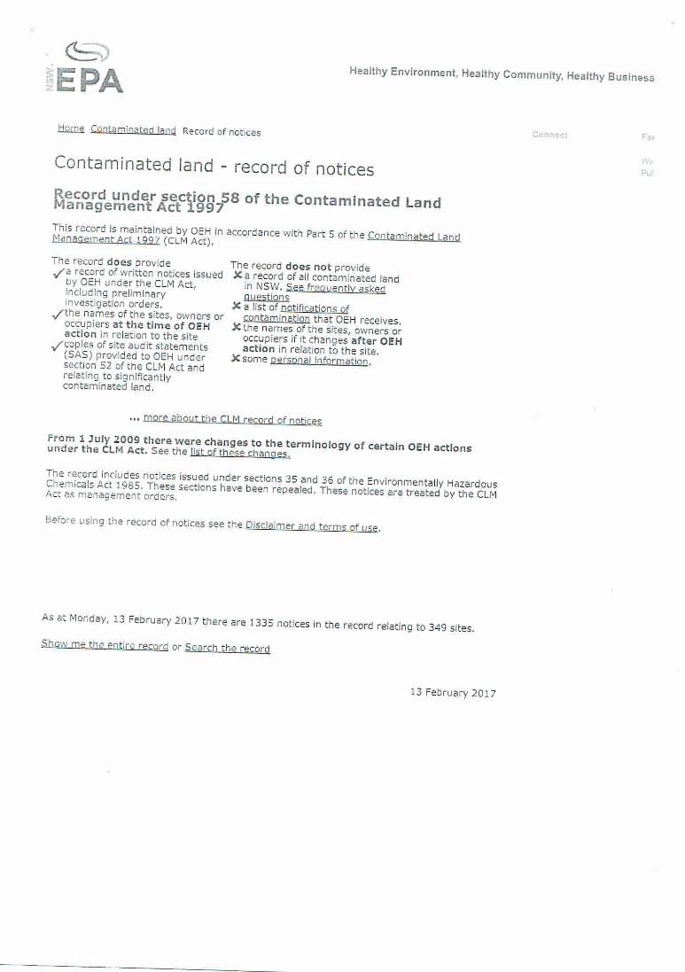


APPENDIX D
TEST PIT LOGS
Project Proposed Development Job No 13942/1
Location 14 Clarke Street Refer to Drawing No 13942/1-AA1
Riverstone Logged & Sampled by LY/SS
TABLE 1 Page 1 of 14
Test pit Depth
(m) Sample
Depth (m) Date Time Material Description Remarks*
NS = No Sample *Odour (O), Discolouration (D), Petroleum Hydrocarbon Staining (PHS), Asbestos Containing Material (ACM), Ash Material (ASHM), Demolition Waste (DW), Groundwater (GW), Perched Water (PW) PID reading etc.
Form No 0009-Rev7 Jun 2014
GG EEOOTTEECCHHNNIIQQUUEE PPTTYY LLTTDD
TP1 0-0.15 0-0.15 02/02/2017 - FILL: Silty Clay, medium plasticity,
brown, with gravel
0.15 Test pit terminated due to access limitation
TP2 0-0.15 0-0.15 02/02/2017 - FILL: Silty Clay, low to medium
plasticity, brown, with root fibres
Fibro-cement pieces,
potential asbestos containing material (ACM) observed in TP2 (0-0.15m)
and representative sample, FCP8, was collected for analysis
0.15 Test pit terminated due to access
limitation
TP3 0-0.4 0-0.15 02/02/2017 - FILL: Silty Clay, medium plasticity,
brown, with gravel
0.4-0.6 0.45-0.55 (CI) Silty CLAY, medium plasticity,
brown
TP4 0-0.3 0-0.15 02/02/2017 - TOPSOIL: Gravelly Silt, low plasticity, grey, with inclusion of shale fragments
0.3-0.6 NS (CI) Silty Clay, medium plasticity, brown
TP5 0-0.3 0-0.15 02/02/2017 - TOPSOIL: Gravelly Silt, low plasticity, grey, with inclusion of shale fragments
0.3-0.6 NS (CI) Silty Clay, medium plasticity, brown
TP6 0-0.3 0-0.15 02/02/2017 - TOPSOIL: Gravelly Silt, low plasticity, grey, with inclusion of shale fragments
0.3-0.6 NS (CI) Silty Clay, medium plasticity, brown
TP7 0-0.3 0-0.15 02/02/2017 - TOPSOIL: Gravelly Silt, low plasticity, grey, with inclusion of shale fragments
0.3-0.6 NS (CI) Silty Clay, medium plasticity, brown
TP8 0-0.3 0-0.15 02/02/2017 - TOPSOIL: Gravelly Silt, low plasticity, grey, with inclusion of shale fragments
0.3-0.6 NS (CI) Silty Clay, medium plasticity, brown
TP9 0-0.3 0-0.15 02/02/2017 - TOPSOIL: Gravelly Silt, low plasticity, grey, with inclusion of shale fragments
0.3-0.6 NS (CI) Silty Clay, medium plasticity, brown
Project Proposed Development Job No 13942/1
Location 14 Clarke Street Refer to Drawing No 13942/1-AA1
Riverstone Logged & Sampled by LY/SS
TABLE 1 Page 2 of 14
Test pit Depth
(m) Sample
Depth (m) Date Time Material Description Remarks*
NS = No Sample *Odour (O), Discolouration (D), Petroleum Hydrocarbon Staining (PHS), Asbestos Containing Material (ACM), Ash Material (ASHM), Demolition Waste (DW), Groundwater (GW), Perched Water (PW) PID reading etc.
Form No 0009-Rev7 Jun 2014
GG EEOOTTEECCHHNNIIQQUUEE PPTTYY LLTTDD
TP10 0-0.3 0-0.15 02/02/2017 - TOPSOIL: Gravelly Silt, low plasticity,
grey, with inclusion of shale fragments
0.3-0.6 NS (CI) Silty Clay, medium plasticity, brown
TP11 0-0.6 0-0.15 02/02/2017 - TOPSOIL: Gravelly Silt, low plasticity,
grey, with inclusion of shale fragments
TP12 0-0.3 0-0.15 02/02/2017 - TOPSOIL: Gravelly Silt, low plasticity, grey, with inclusion of shale fragments
0.3-0.6 NS (CI) Silty Clay, medium plasticity, brown
TP13 0-0.3 0-0.15 02/02/2017 - TOPSOIL: Gravelly Silt, low plasticity, grey, with inclusion of shale fragments
0.3-0.6 NS (CI) Silty Clay, medium plasticity, brown
TP14 0-0.3 0-0.15 02/02/2017 - TOPSOIL: Gravelly Silt, low plasticity, grey, with inclusion of shale fragments
0.3-0.6 NS (CI) Silty Clay, medium plasticity, brown
TP15 0-0.3 0-0.15 02/02/2017 - TOPSOIL: Gravelly Silt, low plasticity, grey, with inclusion of shale fragments
0.3-0.6 NS (CI) Silty Clay, medium plasticity, brown
TP16 0-0.3 0-0.15 02/02/2017 - TOPSOIL: Gravelly Silt, low plasticity, grey, with inclusion of shale fragments
0.3-0.6 NS (CI) Silty Clay, medium plasticity, brown
TP17 0-0.3 0-0.15 02/02/2017 - TOPSOIL: Gravelly Silt, low plasticity, grey, with inclusion of shale fragments
0.3-0.6 NS (CI) Silty Clay, medium plasticity, brown
TP18 0-0.3 0-0.15 02/02/2017 - TOPSOIL: Gravelly Silt, low plasticity, grey, with inclusion of shale fragments
0.3-0.6 NS (CI) Silty Clay, medium plasticity, brown
TP19 0-0.3 0-0.15 02/02/2017 - TOPSOIL: Gravelly Silt, low plasticity, grey, with inclusion of shale fragments
0.3-0.6 NS (CI) Silty Clay, medium plasticity, brown
Project Proposed Development Job No 13942/1
Location 14 Clarke Street Refer to Drawing No 13942/1-AA1
Riverstone Logged & Sampled by LY/SS
TABLE 1 Page 3 of 14
Test pit Depth
(m) Sample
Depth (m) Date Time Material Description Remarks*
NS = No Sample *Odour (O), Discolouration (D), Petroleum Hydrocarbon Staining (PHS), Asbestos Containing Material (ACM), Ash Material (ASHM), Demolition Waste (DW), Groundwater (GW), Perched Water (PW) PID reading etc.
Form No 0009-Rev7 Jun 2014
GG EEOOTTEECCHHNNIIQQUUEE PPTTYY LLTTDD
TP20 0-0.6 0-0.15 02/02/2017 - TOPSOIL: Gravelly Silt, low plasticity,
grey, with inclusion of shale fragments
0.6-0.8 NS (CI) Silty Clay, medium plasticity, brown
TP21 0-0.6 0-0.15 02/02/2017 - TOPSOIL: Gravelly Silt, low plasticity,
grey, with inclusion of shale fragments
0.6-0.8 NS (CI) Silty Clay, medium plasticity, brown
TP22 0-0.6 0-0.15 02/02/2017 - TOPSOIL: Gravelly Silt, low plasticity,
grey, with inclusion of shale fragments
0.6-0.8 NS (CI) Silty Clay, medium plasticity, brown
TP23 0-0.6 0-0.15 02/02/2017 - TOPSOIL: Gravelly Silt, low plasticity,
grey, with inclusion of shale fragments
TP24 0-0.6 0-0.15 02/02/2017 - TOPSOIL: Gravelly Silt, low plasticity, grey, with inclusion of shale fragments
TP25 0-0.3 0-0.15 02/02/2017 - TOPSOIL: Gravelly Silt, low plasticity,
grey, with inclusion of shale fragments
0.3-0.6 NS (CI) Silty Clay, medium plasticity, brown
TP26 0-0.3 0-0.15 02/02/2017 - TOPSOIL: Gravelly Silt, low plasticity,
grey, with inclusion of shale fragments
0.3-0.6 NS (CI) Silty Clay, medium plasticity, brown
TP27 0-0.3 0-0.15 02/02/2017 - TOPSOIL: Gravelly Silt, low plasticity,
grey, with inclusion of shale fragments
0.3-0.6 NS (CI) Silty Clay, medium plasticity, brown
TP28 0-0.3 0-0.15 02/02/2017 - TOPSOIL: Gravelly Silt, low plasticity,
grey, with inclusion of shale fragments
0.3-0.6 NS (CI) Silty Clay, medium plasticity, brown
TP29 0-0.3 0-0.15 02/02/2017 - TOPSOIL: Gravelly Silt, low plasticity,
grey, with inclusion of shale fragments
0.3-0.6 NS (CI) Silty Clay, medium plasticity, brown
TP30 0-0.3 0-0.15 02/02/2017 - TOPSOIL: Gravelly Silt, low plasticity,
grey, with inclusion of shale fragments
0.3-0.6 NS (CI) Silty Clay, medium plasticity, brown

Project Proposed Development Job No 13942/1
Location 14 Clarke Street Refer to Drawing No 13942/1-AA1
Riverstone Logged & Sampled by LY/SS
TABLE 1 Page 4 of 14
Test pit Depth
(m) Sample
Depth (m) Date Time Material Description Remarks*
NS = No Sample *Odour (O), Discolouration (D), Petroleum Hydrocarbon Staining (PHS), Asbestos Containing Material (ACM), Ash Material (ASHM), Demolition Waste (DW), Groundwater (GW), Perched Water (PW) PID reading etc.
Form No 0009-Rev7 Jun 2014
GG EEOOTTEECCHHNNIIQQUUEE PPTTYY LLTTDD
TP31 0-0.2 0-0.15 01/02/2017 - TOPSOIL: Gravelly Silt, low plasticity,
grey, with inclusion of shale fragments
0.2-0.7 NS (CI) Silty Clay, medium plasticity, brown
TP32 0-0.2 0-0.15 01/02/2017 - TOPSOIL: Gravelly Silt, low plasticity,
grey, with inclusion of shale fragments
0.2-0.7 NS (CI) Silty Clay, medium plasticity, brown
TP33 0-0.2 0-0.15 01/02/2017 - TOPSOIL: Gravelly Silt, low plasticity,
grey, with inclusion of shale fragments
0.2-0.7 NS (CI) Silty Clay, medium plasticity, brown
TP34 0-0.2 0-0.15 01/02/2017 - TOPSOIL: Gravelly Silt, low plasticity,
grey, with inclusion of shale fragments
0.2-0.7 NS (CI) Silty Clay, medium plasticity, brown
TP35 0-0.2 0-0.15 01/02/2017 - TOPSOIL: Gravelly Silt, low plasticity,
grey, with inclusion of shale fragments
0.2-0.7 NS (CI) Silty Clay, medium plasticity, brown
TP36 0-0.2 0-0.15 01/02/2017 - TOPSOIL: Gravelly Silt, low plasticity,
grey, with inclusion of shale fragments
0.2-0.7 NS (CI) Silty Clay, medium plasticity, brown
TP37 0-0.2 0-0.15 01/02/2017 - TOPSOIL: Gravelly Silt, low plasticity,
grey, with inclusion of shale fragments
0.2-0.7 NS (CI) Silty Clay, medium plasticity, brown
TP38 0-0.2 0-0.15 01/02/2017 - TOPSOIL: Gravelly Silt, low plasticity,
grey, with inclusion of shale fragments
0.2-0.7 NS (CI) Silty Clay, medium plasticity, brown
TP39 0-0.2 0-0.15 01/02/2017 - TOPSOIL: Gravelly Silt, low plasticity,
grey, with inclusion of shale fragments
0.2-0.7 NS (CI) Silty Clay, medium plasticity, brown
TP40 0-0.2 0-0.15 01/02/2017 - TOPSOIL: Gravelly Silt, low plasticity,
grey, with inclusion of shale fragments
0.2-0.7 NS (CI) Silty Clay, medium plasticity, brown
Project Proposed Development Job No 13942/1
Location 14 Clarke Street Refer to Drawing No 13942/1-AA1
Riverstone Logged & Sampled by LY/SS
TABLE 1 Page 5 of 14
Test pit Depth
(m) Sample
Depth (m) Date Time Material Description Remarks*
NS = No Sample *Odour (O), Discolouration (D), Petroleum Hydrocarbon Staining (PHS), Asbestos Containing Material (ACM), Ash Material (ASHM), Demolition Waste (DW), Groundwater (GW), Perched Water (PW) PID reading etc.
Form No 0009-Rev7 Jun 2014
GG EEOOTTEECCHHNNIIQQUUEE PPTTYY LLTTDD
TP41 0-0.2 0-0.15 01/02/2017 - TOPSOIL: Gravelly Silt, low plasticity,
grey, with inclusion of shale fragments
0.2-0.7 NS (CI) Silty Clay, medium plasticity, brown
TP42 0-1.0 0-0.15 01/02/2017 - FILL: Gravelly Silty Clay, low plasticity,
brown, with inclusion of glass tile, concrete and sandstone fragments
0.5-0.8
TP43 0-0.2 0-0.15 01/02/2017 - TOPSOIL: Gravelly Silt, low plasticity, grey, with inclusion of shale fragments
0.2-0.7 NS (CI) Silty Clay, medium plasticity, brown
TP44 0-0.2 0-0.15 01/02/2017 - TOPSOIL: Gravelly Silt, low plasticity, grey, with inclusion of shale fragments
0.2-0.7 NS (CI) Silty Clay, medium plasticity, brown
TP45 0-0.2 0-0.15 01/02/2017 - TOPSOIL: Gravelly Silt, low plasticity, grey, with inclusion of shale fragments
0.2-0.7 NS (CI) Silty Clay, medium plasticity, brown
TP46 0-0.2 0-0.15 01/02/2017 - TOPSOIL: Gravelly Silt, low plasticity, grey, with inclusion of shale fragments
0.2-0.7 NS (CI) Silty Clay, medium plasticity, brown
TP47 0-0.2 0-0.15 01/02/2017 - TOPSOIL: Gravelly Silt, low plasticity, grey, with inclusion of shale fragments
0.2-0.7 NS (CI) Silty Clay, medium plasticity, brown
TP48 0-0.2 0-0.15 01/02/2017 - TOPSOIL: Gravelly Silt, low plasticity, grey, with inclusion of shale fragments
0.2-0.7 NS (CI) Silty Clay, medium plasticity, brown
TP49 0-0.2 0-0.15 01/02/2017 - TOPSOIL: Gravelly Silt, low plasticity, grey, with inclusion of shale fragments
0.2-0.7 NS (CI) Silty Clay, medium plasticity, brown
TP50 0-0.2 0-0.15 01/02/2017 - TOPSOIL: Gravelly Silt, low plasticity, grey, with inclusion of shale fragments
0.2-0.7 NS (CI) Silty Clay, medium plasticity, brown

Project Proposed Development Job No 13942/1
Location 14 Clarke Street Refer to Drawing No 13942/1-AA1
Riverstone Logged & Sampled by LY/SS
TABLE 1 Page 6 of 14
Test pit Depth
(m) Sample
Depth (m) Date Time Material Description Remarks*
NS = No Sample *Odour (O), Discolouration (D), Petroleum Hydrocarbon Staining (PHS), Asbestos Containing Material (ACM), Ash Material (ASHM), Demolition Waste (DW), Groundwater (GW), Perched Water (PW) PID reading etc.
Form No 0009-Rev7 Jun 2014
GG EEOOTTEECCHHNNIIQQUUEE PPTTYY LLTTDD
TP51 0-0.2 0-0.15 01/02/2017 - TOPSOIL: Gravelly Silt, low plasticity,
grey, with inclusion of shale fragments
0.2-0.7 NS (CI) Silty Clay, medium plasticity, brown
TP52 0-0.2 0-0.15 01/02/2017 - TOPSOIL: Gravelly Silt, low plasticity,
grey, with inclusion of shale fragments
0.2-0.7 NS (CI) Silty Clay, medium plasticity, brown
TP53 0-0.2 0-0.15 01/02/2017 - TOPSOIL: Gravelly Silt, low plasticity,
grey, with inclusion of shale fragments
0.2-0.7 NS (CI) Silty Clay, medium plasticity, brown
TP54 0-0.2 0-0.15 01/02/2017 - TOPSOIL: Gravelly Silt, low plasticity,
grey, with inclusion of shale fragments
0.2-0.7 NS (CI) Silty Clay, medium plasticity, brown
TP55 0-0.2 0-0.15 01/02/2017 - TOPSOIL: Gravelly Silt, low plasticity,
grey, with inclusion of shale fragments
0.2-0.7 NS (CI) Silty Clay, medium plasticity, brown
TP56 0-0.2 0-0.15 01/02/2017 - TOPSOIL: Gravelly Silt, low plasticity,
grey, with inclusion of shale fragments
0.2-0.7 NS (CI) Silty Clay, medium plasticity, brown
TP57 0-0.2 0-0.15 01/02/2017 - TOPSOIL: Gravelly Silt, low plasticity,
grey, with inclusion of shale fragments
0.2-0.7 NS (CI) Silty Clay, medium plasticity, brown
TP58 0-0.2 0-0.15 01/02/2017 - TOPSOIL: Gravelly Silt, low plasticity,
grey, with inclusion of shale fragments
0.2-0.7 NS (CI) Silty Clay, medium plasticity, brown
TP59 0-0.2 0-0.15 01/02/2017 - TOPSOIL: Gravelly Silt, low plasticity,
grey, with inclusion of shale fragments
0.2-0.7 NS (CI) Silty Clay, medium plasticity, brown
TP60 0-0.2 0-0.15 01/02/2017 - TOPSOIL: Gravelly Silt, low plasticity,
grey, with inclusion of shale fragments
0.2-0.7 NS (CI) Silty Clay, medium plasticity, brown

Project Proposed Development Job No 13942/1
Location 14 Clarke Street Refer to Drawing No 13942/1-AA1
Riverstone Logged & Sampled by LY/SS
TABLE 1 Page 7 of 14
Test pit Depth
(m) Sample
Depth (m) Date Time Material Description Remarks*
NS = No Sample *Odour (O), Discolouration (D), Petroleum Hydrocarbon Staining (PHS), Asbestos Containing Material (ACM), Ash Material (ASHM), Demolition Waste (DW), Groundwater (GW), Perched Water (PW) PID reading etc.
Form No 0009-Rev7 Jun 2014
GG EEOOTTEECCHHNNIIQQUUEE PPTTYY LLTTDD
TP61 0-0.2 0-0.15 31/01/2017 - TOPSOIL: Gravelly Silt, low plasticity,
grey, with inclusion of shale fragments
0.2-0.7 NS (CI) Silty Clay, medium plasticity, brown
TP62 0-0.2 0-0.15 31/01/2017 - TOPSOIL: Gravelly Silt, low plasticity,
grey, with inclusion of shale fragments
0.2-0.7 NS (CI) Silty Clay, medium plasticity, brown
TP63 0-0.2 0-0.15 31/01/2017 - TOPSOIL: Gravelly Silt, low plasticity,
grey, with inclusion of shale fragments
0.2-0.7 NS (CI) Silty Clay, medium plasticity, brown
TP64 0-0.2 0-0.15 31/01/2017 - TOPSOIL: Gravelly Silt, low plasticity,
grey, with inclusion of shale fragments
0.2-0.7 NS (CI) Silty Clay, medium plasticity, brown
TP65 0-0.2 0-0.15 31/01/2017 - TOPSOIL: Gravelly Silt, low plasticity,
grey, with inclusion of shale fragments
0.2-0.7 NS (CI) Silty Clay, medium plasticity, brown
TP66 0-0.2 0-0.15 31/01/2017 - TOPSOIL: Gravelly Silt, low plasticity,
grey, with inclusion of shale fragments
0.2-0.7 NS (CI) Silty Clay, medium plasticity, brown
TP67 0-0.2 0-0.15 31/01/2017 - TOPSOIL: Gravelly Silt, low plasticity,
grey, with inclusion of shale fragments
0.2-0.7 NS (CI) Silty Clay, medium plasticity, brown
TP68 0-0.2 0-0.15 31/01/2017 - TOPSOIL: Gravelly Silt, low plasticity,
grey, with inclusion of shale fragments
0.2-0.7 NS (CI) Silty Clay, medium plasticity, brown
TP69 0-0.2 0-0.15 31/01/2017 - TOPSOIL: Gravelly Silt, low plasticity,
grey, with inclusion of shale fragments
0.2-0.7 NS (CI) Silty Clay, medium plasticity, brown
TP70 0-0.2 0-0.15 31/01/2017 - TOPSOIL: Gravelly Silt, low plasticity, grey, with inclusion of shale fragments
0.2-0.7 NS (CI) Silty Clay, medium plasticity, brown

Project Proposed Development Job No 13942/1
Location 14 Clarke Street Refer to Drawing No 13942/1-AA1
Riverstone Logged & Sampled by LY/SS
TABLE 1 Page 8 of 14
Test pit Depth
(m) Sample
Depth (m) Date Time Material Description Remarks*
NS = No Sample *Odour (O), Discolouration (D), Petroleum Hydrocarbon Staining (PHS), Asbestos Containing Material (ACM), Ash Material (ASHM), Demolition Waste (DW), Groundwater (GW), Perched Water (PW) PID reading etc.
Form No 0009-Rev7 Jun 2014
GG EEOOTTEECCHHNNIIQQUUEE PPTTYY LLTTDD
TP71 0-0.2 0-0.15 31/01/2017 - TOPSOIL: Gravelly Silt, low plasticity,
grey, with inclusion of shale fragments
0.2-0.7 NS (CI) Silty Clay, medium plasticity, brown
TP72 0-0.2 0-0.15 31/01/2017 - TOPSOIL: Gravelly Silt, low plasticity,
grey, with inclusion of shale fragments
0.2-0.7 NS (CI) Silty Clay, medium plasticity, brown
TP73 0-0.2 0-0.15 31/01/2017 - TOPSOIL: Gravelly Silt, low plasticity,
grey, with inclusion of shale fragments
0.2-0.7 NS (CI) Silty Clay, medium plasticity, brown
TP74 0-0.2 0-0.15 31/01/2017 - TOPSOIL: Gravelly Silt, low plasticity,
grey, with inclusion of shale fragments
0.2-0.7 NS (CI) Silty Clay, medium plasticity, brown
TP75 0-0.2 0-0.15 31/01/2017 - TOPSOIL: Gravelly Silt, low plasticity,
grey, with inclusion of shale fragments
0.2-0.7 NS (CI) Silty Clay, medium plasticity, brown
TP76 0-0.2 0-0.15 31/01/2017 - TOPSOIL: Gravelly Silt, low plasticity,
grey, with inclusion of shale fragments
0.2-0.7 NS (CI) Silty Clay, medium plasticity, brown
TP77 0-0.2 0-0.15 31/01/2017 - TOPSOIL: Gravelly Silt, low plasticity,
grey, with inclusion of shale fragments
0.2-0.7 NS (CI) Silty Clay, medium plasticity, brown
TP78 0-0.2 0-0.15 31/01/2017 - TOPSOIL: Gravelly Silt, low plasticity,
grey, with inclusion of shale fragments
0.2-0.7 NS (CI) Silty Clay, medium plasticity, brown
TP79 0-0.2 0-0.15 31/01/2017 - TOPSOIL: Gravelly Silt, low plasticity,
grey, with inclusion of shale fragments
0.2-0.7 NS (CI) Silty Clay, medium plasticity, brown
TP80 0-0.2 0-0.15 31/01/2017 - TOPSOIL: Gravelly Silt, low plasticity, grey, with inclusion of shale fragments
0.2-0.7 NS (CI) Silty Clay, medium plasticity, brown

Project Proposed Development Job No 13942/1
Location 14 Clarke Street Refer to Drawing No 13942/1-AA1
Riverstone Logged & Sampled by LY/SS
TABLE 1 Page 9 of 14
Test pit Depth
(m) Sample
Depth (m) Date Time Material Description Remarks*
NS = No Sample *Odour (O), Discolouration (D), Petroleum Hydrocarbon Staining (PHS), Asbestos Containing Material (ACM), Ash Material (ASHM), Demolition Waste (DW), Groundwater (GW), Perched Water (PW) PID reading etc.
Form No 0009-Rev7 Jun 2014
GG EEOOTTEECCHHNNIIQQUUEE PPTTYY LLTTDD
TP81 0-0.2 0-0.15 31/01/2017 - TOPSOIL: Gravelly Silt, low plasticity,
grey, with inclusion of shale fragments
0.2-0.7 NS (CI) Silty Clay, medium plasticity, brown
TP82 0-0.2 0-0.15 31/01/2017 - TOPSOIL: Gravelly Silt, low plasticity,
grey, with inclusion of shale fragments
0.2-0.7 NS (CI) Silty Clay, medium plasticity, brown
TP83 0-0.2 0-0.15 31/01/2017 - TOPSOIL: Gravelly Silt, low plasticity,
grey, with inclusion of shale fragments
0.2-0.7 NS (CI) Silty Clay, medium plasticity, brown
TP84 0-0.2 0-0.15 31/01/2017 - TOPSOIL: Gravelly Silt, low plasticity,
grey, with inclusion of shale fragments
0.2-0.7 NS (CI) Silty Clay, medium plasticity, brown
TP85 0-0.2 0-0.15 31/01/2017 - TOPSOIL: Gravelly Silt, low plasticity,
grey, with inclusion of shale fragments
0.2-0.7 NS (CI) Silty Clay, medium plasticity, brown
TP86 0-0.2 0-0.15 31/01/2017 - TOPSOIL: Gravelly Silt, low plasticity,
grey, with inclusion of shale fragments
0.2-0.7 NS (CI) Silty Clay, medium plasticity, brown
TP87 0-0.2 0-0.15 31/01/2017 - TOPSOIL: Gravelly Silt, low plasticity,
grey, with inclusion of shale fragments
0.2-0.7 NS (CI) Silty Clay, medium plasticity, brown
TP88 0-0.2 0-0.15 31/01/2017 - TOPSOIL: Gravelly Silt, low plasticity,
grey, with inclusion of shale fragments
0.2-0.7 NS (CI) Silty Clay, medium plasticity, brown
TP89 0-0.2 0-0.15 31/01/2017 - TOPSOIL: Gravelly Silt, low plasticity,
grey, with inclusion of shale fragments
0.2-0.7 NS (CI) Silty Clay, medium plasticity, brown
TP90 0-0.2 0-0.15 31/01/2017 - TOPSOIL: Gravelly Silt, low plasticity, grey, with inclusion of shale fragments
0.2-0.7 NS (CI) Silty Clay, medium plasticity, brown
Project Proposed Development Job No 13942/1
Location 14 Clarke Street Refer to Drawing No 13942/1-AA1
Riverstone Logged & Sampled by LY/SS
TABLE 1 Page 10 of 14
Test pit Depth
(m) Sample
Depth (m) Date Time Material Description Remarks*
NS = No Sample *Odour (O), Discolouration (D), Petroleum Hydrocarbon Staining (PHS), Asbestos Containing Material (ACM), Ash Material (ASHM), Demolition Waste (DW), Groundwater (GW), Perched Water (PW) PID reading etc.
Form No 0009-Rev7 Jun 2014
GG EEOOTTEECCHHNNIIQQUUEE PPTTYY LLTTDD
TP91 0-0.2 0-0.15 30/01/2017 - TOPSOIL: Gravelly Silt, low plasticity,
grey, with inclusion of shale fragments
0.2-0.7 NS (CI) Silty Clay, medium plasticity, brown
TP92 0-0.2 0-0.15 30/01/2017 - TOPSOIL: Gravelly Silt, low plasticity,
grey, with inclusion of shale fragments
0.2-0.7 NS (CI) Silty Clay, medium plasticity, brown
TP93 0-0.2 0-0.15 30/01/2017 - TOPSOIL: Gravelly Silt, low plasticity,
grey, with inclusion of shale fragments
0.2-0.7 NS (CI) Silty Clay, medium plasticity, brown
TP94 0-0.2 0-0.15 30/01/2017 - TOPSOIL: Gravelly Silt, low plasticity,
grey, with inclusion of shale fragments
0.2-0.7 NS (CI) Silty Clay, medium plasticity, brown
TP95 0-0.2 0-0.15 30/01/2017 - TOPSOIL: Gravelly Silt, low plasticity,
grey, with inclusion of shale fragments
0.2-0.7 NS (CI) Silty Clay, medium plasticity, brown
TP96 0-0.2 0-0.15 30/01/2017 - TOPSOIL: Gravelly Silt, low plasticity,
grey, with inclusion of shale fragments
0.2-0.7 NS (CI) Silty Clay, medium plasticity, brown
TP97 0-0.2 0-0.15 30/01/2017 - TOPSOIL: Gravelly Silt, low plasticity,
grey, with inclusion of shale fragments
0.2-0.7 NS (CI) Silty Clay, medium plasticity, brown
TP98 0-0.2 0-0.15 30/01/2017 - TOPSOIL: Gravelly Silt, low plasticity,
grey, with inclusion of shale fragments
0.2-0.7 NS (CI) Silty Clay, medium plasticity, brown
TP99 0-0.2 0-0.15 30/01/2017 - TOPSOIL: Gravelly Silt, low plasticity,
grey, with inclusion of shale fragments
0.2-0.7 NS (CI) Silty Clay, medium plasticity, brown
TP100 0-0.2 0-0.15 30/01/2017 - TOPSOIL: Gravelly Silt, low plasticity, grey, with inclusion of shale fragments
0.2-0.7 NS (CI) Silty Clay, medium plasticity, brown

Project Proposed Development Job No 13942/1
Location 14 Clarke Street Refer to Drawing No 13942/1-AA1
Riverstone Logged & Sampled by LY/SS
TABLE 1 Page 11 of 14
Test pit Depth
(m) Sample
Depth (m) Date Time Material Description Remarks*
NS = No Sample *Odour (O), Discolouration (D), Petroleum Hydrocarbon Staining (PHS), Asbestos Containing Material (ACM), Ash Material (ASHM), Demolition Waste (DW), Groundwater (GW), Perched Water (PW) PID reading etc.
Form No 0009-Rev7 Jun 2014
GG EEOOTTEECCHHNNIIQQUUEE PPTTYY LLTTDD
TP101 0-0.2 0-0.15 30/01/2017 - TOPSOIL: Gravelly Silt, low plasticity,
grey, with inclusion of shale fragments
0.2-0.7 NS (CI) Silty Clay, medium plasticity, brown
TP102 0-0.2 0-0.15 30/01/2017 - TOPSOIL: Gravelly Silt, low plasticity,
grey, with inclusion of shale fragments
0.2-0.7 NS (CI) Silty Clay, medium plasticity, brown
TP103 0-0.2 0-0.15 30/01/2017 - TOPSOIL: Gravelly Silt, low plasticity,
grey, with inclusion of shale fragments
0.2-0.7 NS (CI) Silty Clay, medium plasticity, brown
TP104 0-0.2 0-0.15 30/01/2017 - TOPSOIL: Gravelly Silt, low plasticity,
grey, with inclusion of shale fragments
0.2-0.7 NS (CI) Silty Clay, medium plasticity, brown
TP105 0-0.2 0-0.15 30/01/2017 - TOPSOIL: Gravelly Silt, low plasticity,
grey, with inclusion of shale fragments
0.2-0.7 NS (CI) Silty Clay, medium plasticity, brown
TP106 0-0.2 0-0.15 30/01/2017 - TOPSOIL: Gravelly Silt, low plasticity,
grey, with inclusion of shale fragments
0.2-0.7 NS (CI) Silty Clay, medium plasticity, brown
TP107 0-0.2 0-0.15 30/01/2017 - TOPSOIL: Gravelly Silt, low plasticity,
grey, with inclusion of shale fragments
0.2-0.7 NS (CI) Silty Clay, medium plasticity, brown
TP108 0-0.2 0-0.15 30/01/2017 - TOPSOIL: Gravelly Silt, low plasticity,
grey, with inclusion of shale fragments
0.2-0.7 NS (CI) Silty Clay, medium plasticity, brown
TP109 0-0.2 0-0.15 30/01/2017 - TOPSOIL: Gravelly Silt, low plasticity,
grey, with inclusion of shale fragments
0.2-0.7 NS (CI) Silty Clay, medium plasticity, brown
TP110 0-0.2 0-0.15 30/01/2017 - TOPSOIL: Gravelly Silt, low plasticity, grey, with inclusion of shale fragments
0.2-0.7 NS (CI) Silty Clay, medium plasticity, brown

Project Proposed Development Job No 13942/1
Location 14 Clarke Street Refer to Drawing No 13942/1-AA1
Riverstone Logged & Sampled by LY/SS
TABLE 1 Page 12 of 14
Test pit Depth
(m) Sample
Depth (m) Date Time Material Description Remarks*
NS = No Sample *Odour (O), Discolouration (D), Petroleum Hydrocarbon Staining (PHS), Asbestos Containing Material (ACM), Ash Material (ASHM), Demolition Waste (DW), Groundwater (GW), Perched Water (PW) PID reading etc.
Form No 0009-Rev7 Jun 2014
GG EEOOTTEECCHHNNIIQQUUEE PPTTYY LLTTDD
TP111 0-0.2 0-0.15 30/01/2017 - TOPSOIL: Gravelly Silt, low plasticity,
grey, with inclusion of shale fragments
0.2-0.7 NS (CI) Silty Clay, medium plasticity, brown
TP112 0-0.2 0-0.15 30/01/2017 - TOPSOIL: Gravelly Silt, low plasticity,
grey, with inclusion of shale fragments
0.2-0.7 NS (CI) Silty Clay, medium plasticity, brown
TP113 0-0.2 0-0.15 30/01/2017 - TOPSOIL: Gravelly Silt, low plasticity,
grey, with inclusion of shale fragments
0.2-0.7 NS (CI) Silty Clay, medium plasticity, brown
TP114 0-0.2 0-0.15 30/01/2017 - TOPSOIL: Gravelly Silt, low plasticity,
grey, with inclusion of shale fragments
0.2-0.7 NS (CI) Silty Clay, medium plasticity, brown
TP115 0-0.2 0-0.15 30/01/2017 - TOPSOIL: Gravelly Silt, low plasticity,
grey, with inclusion of shale fragments
0.2-0.7 NS (CI) Silty Clay, medium plasticity, brown
TP116 0-0.2 0-0.15 30/01/2017 - TOPSOIL: Gravelly Silt, low plasticity,
grey, with inclusion of shale fragments
0.2-0.7 NS (CI) Silty Clay, medium plasticity, brown
TP117 0-0.2 0-0.15 30/01/2017 - TOPSOIL: Gravelly Silt, low plasticity,
grey, with inclusion of shale fragments
0.2-0.7 NS (CI) Silty Clay, medium plasticity, brown
TP118 0-0.2 0-0.15 30/01/2017 - TOPSOIL: Gravelly Silt, low plasticity,
grey, with inclusion of shale fragments
0.2-0.7 NS (CI) Silty Clay, medium plasticity, brown
TP119 0-0.2 0-0.15 30/01/2017 - TOPSOIL: Gravelly Silt, low plasticity,
grey, with inclusion of shale fragments
0.2-0.7 NS (CI) Silty Clay, medium plasticity, brown
TP120 0-0.2 0-0.15 30/01/2017 - TOPSOIL: Gravelly Silt, low plasticity, grey, with inclusion of shale fragments
0.2-0.7 NS (CI) Silty Clay, medium plasticity, brown
Project Proposed Development Job No 13942/1
Location 14 Clarke Street Refer to Drawing No 13942/1-AA1
Riverstone Logged & Sampled by LY/SS
TABLE 1 Page 13 of 14
Test pit Depth
(m) Sample
Depth (m) Date Time Material Description Remarks*
NS = No Sample *Odour (O), Discolouration (D), Petroleum Hydrocarbon Staining (PHS), Asbestos Containing Material (ACM), Ash Material (ASHM), Demolition Waste (DW), Groundwater (GW), Perched Water (PW) PID reading etc.
Form No 0009-Rev7 Jun 2014
GG EEOOTTEECCHHNNIIQQUUEE PPTTYY LLTTDD
SP1 - 0-0.15 02/02/2017 - STOCKPILE, Silty Sand, fine grained,
grey
SP2 - 0-0.15 02/02/2017 - STOCKPILE, Silty Clay, low to medium plasticity, brown, with gravel
SP3 - 0-0.15 02/02/2017 - STOCKPILE, Clay Silt, low plasticity,
brown, with gravel Building debris observed in stockpile
SP4 - 0-0.15 02/02/2017 - STOCKPILE, Clay Silt, low plasticity,
orange-brown, with gravel
Terracotta pipe observed
in stockpile
SP5 - 0-0.15 02/02/2017 - STOCKPILE, Silty Clay, low to medium
plasticity, brown, with gravel
SP6 - 0-0.15 02/02/2017 - STOCKPILE, Silty Clay, low to medium plasticity, brown, with gravel
Concrete boulders observed in stockpile
SP7 - 0-0.15 02/02/2017 - STOCKPILE, Silty Clay, low to medium plasticity, brown, with gravel
Concrete pieces and plastic observed in stockpile
SP8 - 0-0.15 02/02/2017 - STOCKPILE, Sand, fine to medium
grained, grey
SP9 - 0-0.15 02/02/2017 - STOCKPILE, Sand, fine to medium grained, yellow-brown, with sandstone pieces
Building and concrete debris, tyres, plastic items and scrap metals
observed in stockpile
SP10-1 - 0-0.15 02/02/2017 - STOCKPILE, Silty Clay, low to medium plasticity, brown, with gravel
Fibro-cement pieces, potential asbestos containing material (ACM)
observed in SP10 (0-0.15m) and representative sample, FCP6, collected
for analysis
SP10-2 - 0-0.15 02/02/2017 - STOCKPILE, Silty Clay, low to medium plasticity, brown, with gravel
Fibro-cement pieces potential asbestos containing material (ACM)
observed in SP10 (0-0.15m) and representative sample, FCP7, collected
for analysis
SP11 - 0-0.15 02/02/2017 - STOCKPILE, Silty Clay, low to medium plasticity, brown, with gravel
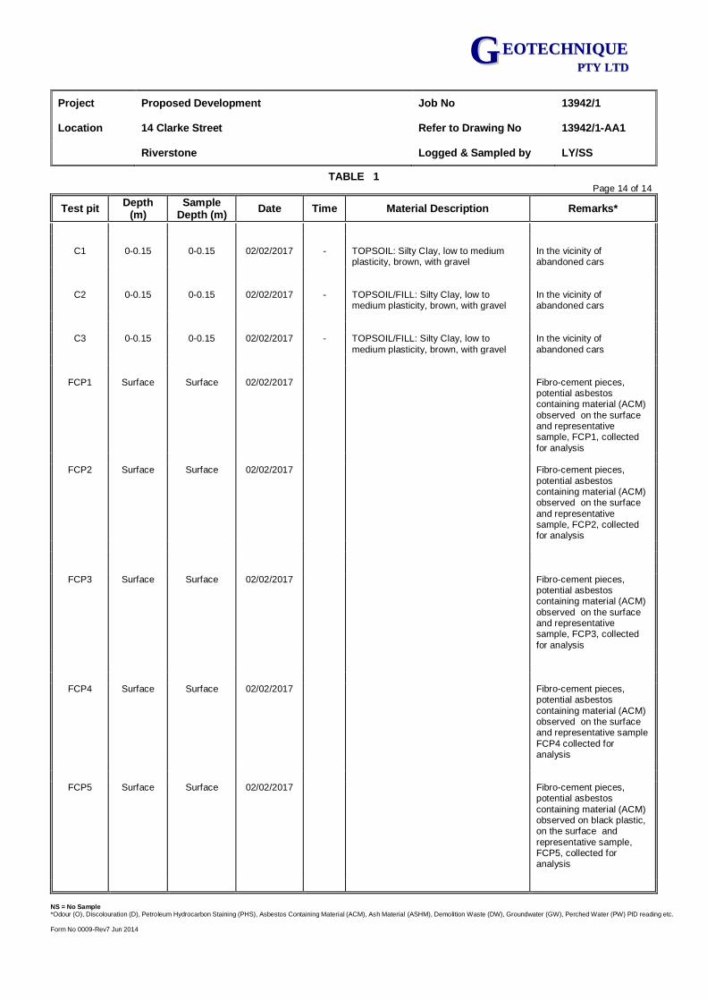
Project Proposed Development Job No 13942/1
Location 14 Clarke Street Refer to Drawing No 13942/1-AA1
Riverstone Logged & Sampled by LY/SS
TABLE 1 Page 14 of 14
Test pit Depth
(m) Sample
Depth (m) Date Time Material Description Remarks*
NS = No Sample *Odour (O), Discolouration (D), Petroleum Hydrocarbon Staining (PHS), Asbestos Containing Material (ACM), Ash Material (ASHM), Demolition Waste (DW), Groundwater (GW), Perched Water (PW) PID reading etc.
Form No 0009-Rev7 Jun 2014
GG EEOOTTEECCHHNNIIQQUUEE PPTTYY LLTTDD
C1 0-0.15 0-0.15 02/02/2017 - TOPSOIL: Silty Clay, low to medium plasticity, brown, with gravel
In the vicinity of abandoned cars
C2 0-0.15 0-0.15 02/02/2017 - TOPSOIL/FILL: Silty Clay, low to
medium plasticity, brown, with gravel In the vicinity of abandoned cars
C3 0-0.15 0-0.15 02/02/2017 - TOPSOIL/FILL: Silty Clay, low to
medium plasticity, brown, with gravel
In the vicinity of
abandoned cars
FCP1 Surface Surface 02/02/2017 Fibro-cement pieces, potential asbestos containing material (ACM)
observed on the surface and representative sample, FCP1, collected
for analysis
FCP2 Surface Surface 02/02/2017 Fibro-cement pieces,
potential asbestos containing material (ACM) observed on the surface
and representative sample, FCP2, collected for analysis
FCP3 Surface Surface 02/02/2017 Fibro-cement pieces, potential asbestos containing material (ACM)
observed on the surface and representative sample, FCP3, collected
for analysis
FCP4 Surface Surface 02/02/2017 Fibro-cement pieces,
potential asbestos
containing material (ACM) observed on the surface and representative sample
FCP4 collected for analysis
FCP5 Surface Surface 02/02/2017 Fibro-cement pieces,
potential asbestos
containing material (ACM) observed on black plastic, on the surface and
representative sample, FCP5, collected for analysis

APPENDIX E
SITE PHOTOGRAPHS
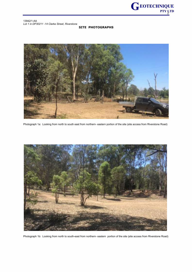
1
13942/1-AA Lot 1 in DP30211 -14 Clarke Street, Riverstone
SITE PHOTOGRAPHS
GG EEOOTTEECCHHNNIIQQUUEE PPTTYY LLTTDD
Photograph 1a: Looking from north to south east from northern- eastern portion of the site (site access from Riverstone Road)
Photograph 1b: Looking from north to south-east from northern- eastern portion of the site (site access from Riverstone Road)

2
13942/1-AA Lot 1 in DP30211 -14 Clarke Street, Riverstone
SITE PHOTOGRAPHS
GG EEOOTTEECCHHNNIIQQUUEE PPTTYY LLTTDD
Photograph 2a: Part of the burn areas with domestic waste(tyres plastic, scrap metals, timber, vehicle parts, etc.( Looking from east to south-west in middle portion of the eastern portion of the site
Photograph 2b: Part of the burn areas with domestic waste(tyres plastic, scrap metals, timber, vehicle parts, etc.( Looking from
east to south-west in middle portion of the eastern portion of the site
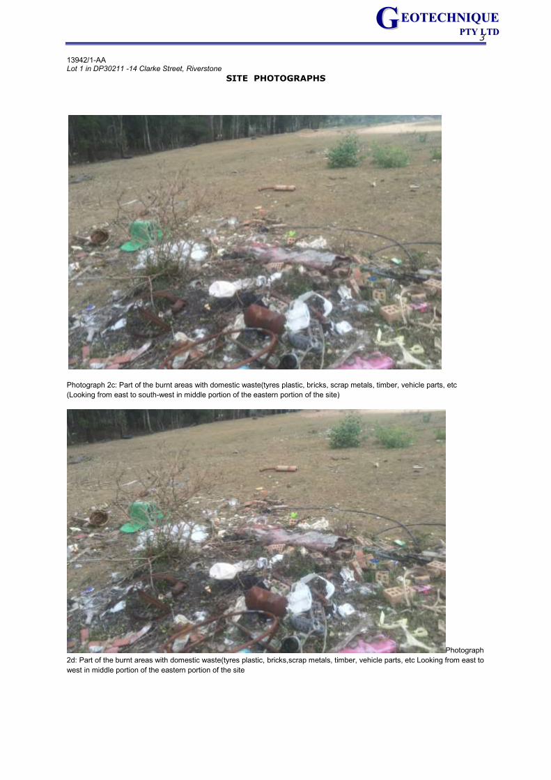
3
13942/1-AA Lot 1 in DP30211 -14 Clarke Street, Riverstone
SITE PHOTOGRAPHS
GG EEOOTTEECCHHNNIIQQUUEE PPTTYY LLTTDD
Photograph 2c: Part of the burnt areas with domestic waste(tyres plastic, bricks, scrap metals, timber, vehicle parts, etc
(Looking from east to south-west in middle portion of the eastern portion of the site)
Photograph
2d: Part of the burnt areas with domestic waste(tyres plastic, bricks,scrap metals, timber, vehicle parts, etc Looking from east to
west in middle portion of the eastern portion of the site
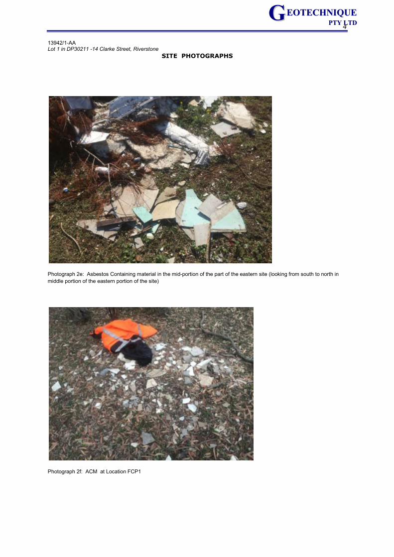
4
13942/1-AA Lot 1 in DP30211 -14 Clarke Street, Riverstone
SITE PHOTOGRAPHS
GG EEOOTTEECCHHNNIIQQUUEE PPTTYY LLTTDD
Photograph 2e: Asbestos Containing material in the mid-portion of the part of the eastern site (looking from south to north in
middle portion of the eastern portion of the site)
Photograph 2f: ACM at Location FCP1
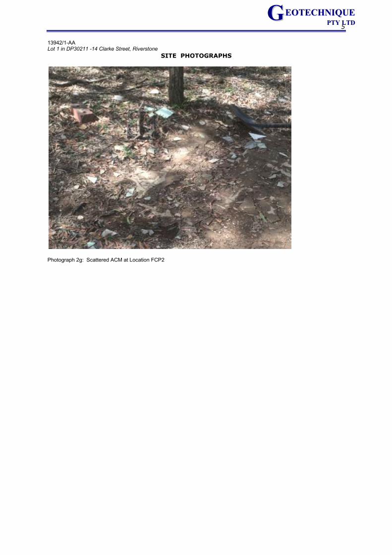
5
13942/1-AA Lot 1 in DP30211 -14 Clarke Street, Riverstone
SITE PHOTOGRAPHS
GG EEOOTTEECCHHNNIIQQUUEE PPTTYY LLTTDD
Photograph 2g: Scattered ACM at Location FCP2
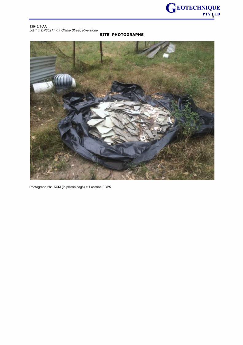
6
13942/1-AA Lot 1 in DP30211 -14 Clarke Street, Riverstone
SITE PHOTOGRAPHS
GG EEOOTTEECCHHNNIIQQUUEE PPTTYY LLTTDD
Photograph 2h: ACM (in plastic bags) at Location FCP5
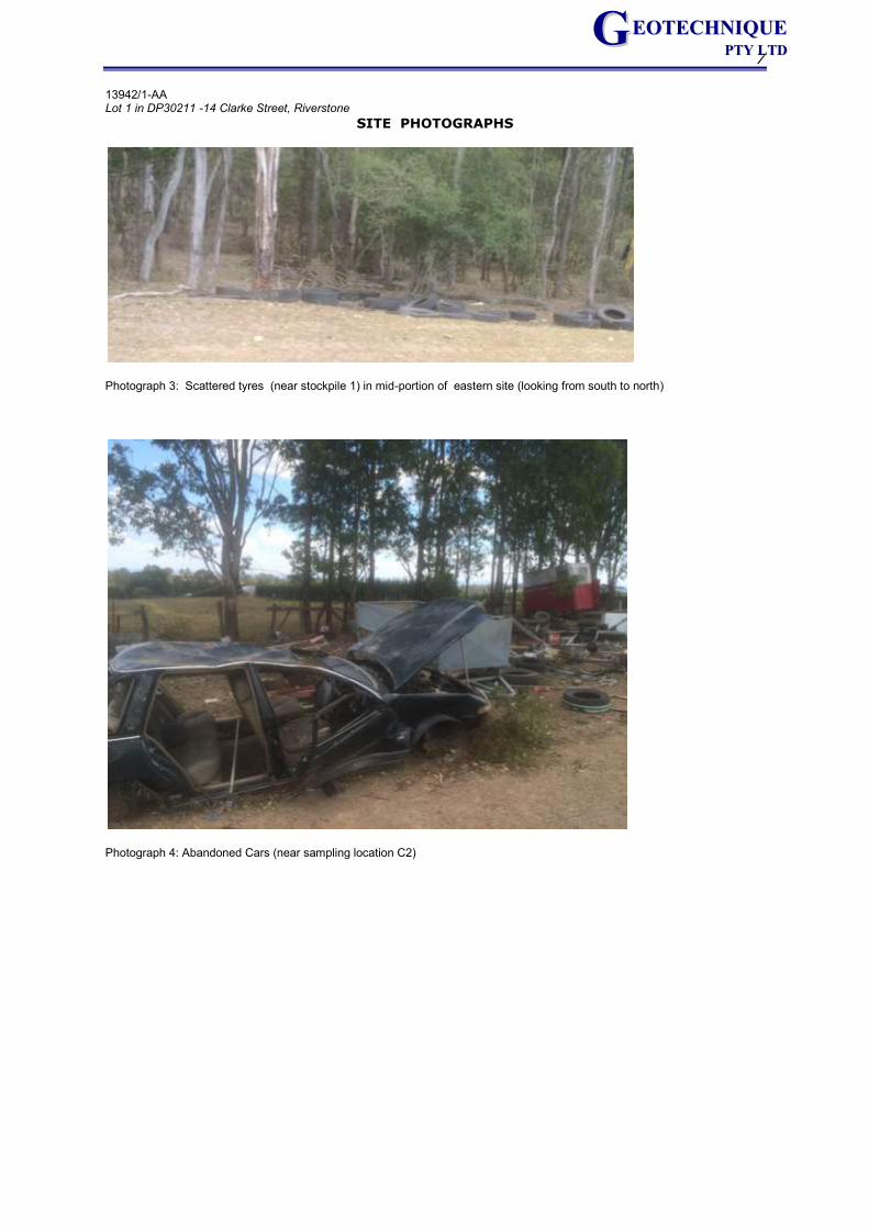
7
13942/1-AA Lot 1 in DP30211 -14 Clarke Street, Riverstone
SITE PHOTOGRAPHS
GG EEOOTTEECCHHNNIIQQUUEE PPTTYY LLTTDD
Photograph 3: Scattered tyres (near stockpile 1) in mid-portion of eastern site (looking from south to north)
Photograph 4: Abandoned Cars (near sampling location C2)
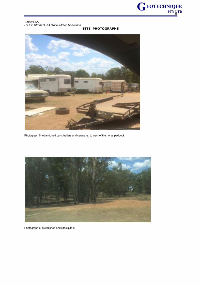
8
13942/1-AA Lot 1 in DP30211 -14 Clarke Street, Riverstone
SITE PHOTOGRAPHS
GG EEOOTTEECCHHNNIIQQUUEE PPTTYY LLTTDD
Photograph 5: Abandoned cars, trailers and caravans, to west of the horse paddock
Photograph 6: Metal shed and Stockpile 8
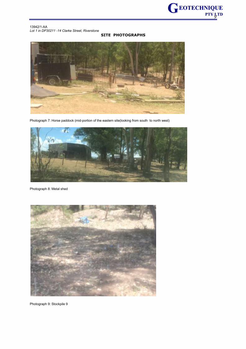
9
13942/1-AA Lot 1 in DP30211 -14 Clarke Street, Riverstone
SITE PHOTOGRAPHS
GG EEOOTTEECCHHNNIIQQUUEE PPTTYY LLTTDD
Photograph 7: Horse paddock (mid-portion of the eastern site(looking from south to north west)
Photograph 8: Metal shed
Photograph 9: Stockpile 9

APPENDIX F
UNEXPECTED FINDS MANAGMENT PROTOCOL
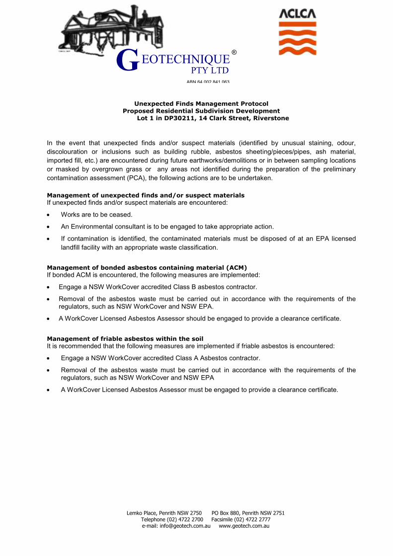
Lemko Place, Penrith NSW 2750 PO Box 880, Penrith NSW 2751 Telephone (02) 4722 2700 Facsimile (02) 4722 2777 e-mail: [email protected] www.geotech.com.au
®
ABN 64 002 841 063
EOTECHNIQUE G PTY LTD
Unexpected Finds Management Protocol Proposed Residential Subdivision Development
Lot 1 in DP30211, 14 Clark Street, Riverstone
In the event that unexpected finds and/or suspect materials (identified by unusual staining, odour,
discolouration or inclusions such as building rubble, asbestos sheeting/pieces/pipes, ash material,
imported fill, etc.) are encountered during future earthworks/demolitions or in between sampling locations
or masked by overgrown grass or any areas not identified during the preparation of the preliminary
contamination assessment (PCA), the following actions are to be undertaken.
Management of unexpected finds and/or suspect materials
If unexpected finds and/or suspect materials are encountered:
Works are to be ceased.
An Environmental consultant is to be engaged to take appropriate action.
If contamination is identified, the contaminated materials must be disposed of at an EPA licensed
landfill facility with an appropriate waste classification.
Management of bonded asbestos containing material (ACM)
If bonded ACM is encountered, the following measures are implemented:
Engage a NSW WorkCover accredited Class B asbestos contractor.
Removal of the asbestos waste must be carried out in accordance with the requirements of the regulators, such as NSW WorkCover and NSW EPA.
A WorkCover Licensed Asbestos Assessor should be engaged to provide a clearance certificate.
Management of friable asbestos within the soil
It is recommended that the following measures are implemented if friable asbestos is encountered:
Engage a NSW WorkCover accredited Class A Asbestos contractor.
Removal of the asbestos waste must be carried out in accordance with the requirements of the regulators, such as NSW WorkCover and NSW EPA
A WorkCover Licensed Asbestos Assessor must be engaged to provide a clearance certificate.

APPENDIX G
ENVIRONMENTAL NOTES
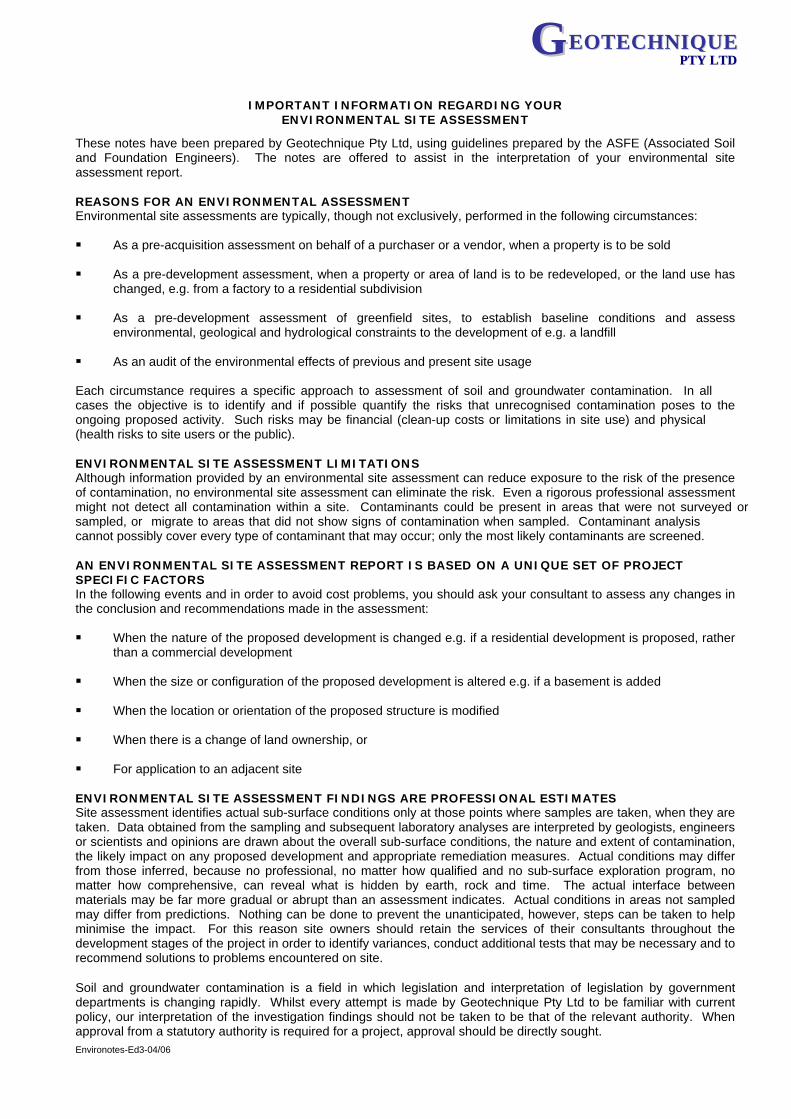
Environotes-Ed3-04/06
GGEEOOTTEECCHHNNIIQQUUEEPPTTYY LLTTDD
IMPORTANT INFORMATION REGARDING YOUR ENVIRONMENTAL SITE ASSESSMENT
These notes have been prepared by Geotechnique Pty Ltd, using guidelines prepared by the ASFE (Associated Soil and Foundation Engineers). The notes are offered to assist in the interpretation of your environmental site assessment report. REASONS FOR AN ENVIRONMENTAL ASSESSMENT Environmental site assessments are typically, though not exclusively, performed in the following circumstances: As a pre-acquisition assessment on behalf of a purchaser or a vendor, when a property is to be sold
As a pre-development assessment, when a property or area of land is to be redeveloped, or the land use has
changed, e.g. from a factory to a residential subdivision As a pre-development assessment of greenfield sites, to establish baseline conditions and assess
environmental, geological and hydrological constraints to the development of e.g. a landfill As an audit of the environmental effects of previous and present site usage
Each circumstance requires a specific approach to assessment of soil and groundwater contamination. In all cases the objective is to identify and if possible quantify the risks that unrecognised contamination poses to the ongoing proposed activity. Such risks may be financial (clean-up costs or limitations in site use) and physical (health risks to site users or the public). ENVIRONMENTAL SITE ASSESSMENT LIMITATIONS Although information provided by an environmental site assessment can reduce exposure to the risk of the presence of contamination, no environmental site assessment can eliminate the risk. Even a rigorous professional assessment might not detect all contamination within a site. Contaminants could be present in areas that were not surveyed or sampled, or migrate to areas that did not show signs of contamination when sampled. Contaminant analysis cannot possibly cover every type of contaminant that may occur; only the most likely contaminants are screened. AN ENVIRONMENTAL SITE ASSESSMENT REPORT IS BASED ON A UNIQUE SET OF PROJECT SPECIFIC FACTORS In the following events and in order to avoid cost problems, you should ask your consultant to assess any changes in the conclusion and recommendations made in the assessment: When the nature of the proposed development is changed e.g. if a residential development is proposed, rather
than a commercial development When the size or configuration of the proposed development is altered e.g. if a basement is added
When the location or orientation of the proposed structure is modified
When there is a change of land ownership, or
For application to an adjacent site
ENVIRONMENTAL SITE ASSESSMENT FINDINGS ARE PROFESSIONAL ESTIMATES Site assessment identifies actual sub-surface conditions only at those points where samples are taken, when they are taken. Data obtained from the sampling and subsequent laboratory analyses are interpreted by geologists, engineers or scientists and opinions are drawn about the overall sub-surface conditions, the nature and extent of contamination, the likely impact on any proposed development and appropriate remediation measures. Actual conditions may differ from those inferred, because no professional, no matter how qualified and no sub-surface exploration program, no matter how comprehensive, can reveal what is hidden by earth, rock and time. The actual interface between materials may be far more gradual or abrupt than an assessment indicates. Actual conditions in areas not sampled may differ from predictions. Nothing can be done to prevent the unanticipated, however, steps can be taken to help minimise the impact. For this reason site owners should retain the services of their consultants throughout the development stages of the project in order to identify variances, conduct additional tests that may be necessary and to recommend solutions to problems encountered on site. Soil and groundwater contamination is a field in which legislation and interpretation of legislation by government departments is changing rapidly. Whilst every attempt is made by Geotechnique Pty Ltd to be familiar with current policy, our interpretation of the investigation findings should not be taken to be that of the relevant authority. When approval from a statutory authority is required for a project, approval should be directly sought.
ii Environmental Notes continued
Environotes-Ed3-04/06
G EEOOTTEECCHHNNIIQQUUEE PPTTYY LLTTDD
STABILITY OF SUB-SURFACE CONDITIONS Sub-surface conditions can change by natural processes and site activities. As an environmental site assessment is based on conditions existing at the time of the investigation, project decisions should not be based on environmental site assessment data that may have been affected by time. The consultant should be requested to advise if additional tests are required. ENVIRONMENTAL SITE ASSESSMENTS ARE PERFORMED FOR SPECIFIC PURPOSES AND CLIENTS Environmental site assessments are prepared in response to a specific scope of work required to meet the specific needs of specific individuals e.g. an assessment prepared for a consulting civil engineer may not be adequate to a construction contractor or another consulting civil engineer. An assessment should not be used by other persons for any purpose or by the client for a different purpose. No individual, other than the client, should apply an assessment, even for its intended purpose, without first conferring with the consultant. No person should apply an assessment for any purpose other than that originally contemplated, without first conferring with the consultant. MISINTERPRETATION OF ENVIRONMENTAL SITE ASSESSMENTS Costly problems can occur when design professionals develop plans based on misinterpretation of an environmental site assessment. In order to minimise problems, the environmental consultant should be retained to work with appropriate design professionals, to explain relevant findings and to review the adequacy of plans and specifications relative to contamination issues. LOGS SHOULD NOT BE SEPARATED FROM THE REPORT Borehole and test pit logs are prepared by environmental scientists, engineers or geologists, based upon interpretation of field conditions and laboratory evaluation of field samples. Logs are normally provided in our reports and these would not be redrawn for inclusion in site remediation or other design drawings, as subtle but significant drafting errors or omissions may occur in the transfer process. Photographic reproduction can eliminate this problem, however, contractors can still misinterpret the logs during bid preparation if separated from the text of the assessment. Should this occur, delays and disputes, or unanticipated costs may result. To reduce the likelihood of borehole and test pit log misinterpretation, the complete assessment should be available to persons or organisations involved in the project, such as contractors, for their use. Denial of such access and disclaiming responsibility for the accuracy of sub-surface information does not insulate an owner from the attendant liability. It is critical that the site owner provides all available site information to persons and organisations, such as contractors. READ RESPONSIBILITY CLAUSES CLOSELY An environmental site assessment is based extensively on judgement and opinion; therefore, it is necessarily less exact than other disciplines. This situation has resulted in wholly unwarranted claims being lodged against consultants. In order to aid in prevention of this problem, model clauses have been developed for use in written transmittals. These are definitive clauses, designed to indicate consultant responsibility. Their use helps all parties involved recognise individual responsibilities and formulate appropriate action. Some of these definitive clauses are likely to appear in the environmental site assessment and you are encouraged to read them closely. Your consultant will be happy to give full and frank answers to any questions you may have.