Embed Size (px)
Citation preview
STAG BEETLES Findings of the 1998
National Survey
© Peoples Trust for Endangered Species
All rights reserved. No reproduction, copy or transmission of this publication may be made without written permission. No paragraph of this publication may be
reproduced or transmitted save with written permission or in accordance with the provisions of the Copyright Act 1956 (as amended)
ISBN
British Library Cataloguing-in-publication data.
A catalogue record for this book is available from the British Library
Findings of the 1998 National
Stag Beetle Survey
People’s Trust for Endangered Species
15 Cloisters House
8 Battersea Park Road
London
SW8 4BG
Registered Charity Number 274206
Claire Percy
Georgina Bassford
Valerie Keeble
(1999)
Edited By
Clare Robb
(Dec 2000)
Survey Co-ordinator 1998: Doug Napier
Lead Partner
Champion
Contact Point

i
ACKNOWLEDGMENTS
We would like to thank all those who have helped during the course of this survey; English Nature, The
JNCC, Colchester Museums, The Forestry Commission, Suffolk Naturalists’ Society, The Natural
History Museum, London Wildlife Trust, The Corporation of London, Berks, Bucks and Oxon Wildlife
Trust, Hampshire Wildlife Trust and the London Borough of Bromley and the many other
organisations which joined in so enthusiastically.
We would also like to thank the following individuals for all their help: Dr Roger Key, Clare Bowen,
Alexia Cummins, Susan Sharafi, Rachel Ansell, Tristan Bantock, Claire Tolfrey, Jacquie Flowerdew,
Kate Wenham, Pam Knights, Andrew Moodie, Alison Burton, Julia Chase Grey, Rebecca Fraser,
Robert Morgan, Alexandra Fisher and Angelika Sesterheim. In particular, we would like to thank
Doug Napier, who worked so unstintingly during the 1998 flight season and who was in the front line
fielding the hundreds of public enquiries we received, and also Claire Percy, who played a similar role
in 1999.
We would also like to thank Mike Thurner, Martin Newman, Dr Paul Bright and Bob Smith, and the
FRCA (Farming & Rural Conservation Agency) for their help with the analysis, and MET office for
supplying data.
The outdoor-clothing company, Mileta Tog 24, championed for the stag beetle and PTES is grateful for
the encouragement received from the Director, Mr Brian Ward, and for the financial help he provided.
The production of this report is the result of a cooperative effort by Claire Percy, Georgina Bassford,
Clare Robb and Valerie Keeble.
ii
EXECUTIVE SUMMARY
The survey, whose results are presented here, was carried out during the flight season of 1998. Wide
publicity and a high profile public launch spearheaded by Mr Michael Meacher, the Minister for the
Environment, ensured that a high level of interest among the general public was generated nationwide.
As a result, 100,000 leaflets about the species and its conservation needs were distributed and
approximately 10,000 records of stag beetle sightings were received by PTES.
Analysis of the data shows that the current distribution of the stag beetle has changed little when
compared to its historic range, although anecdotal evidence suggests that its abundance may be
declining in many areas. The stag beetle's stronghold remains the south east with a few populations
persisting in South Wales, the South West of England and areas in Worcestershire. No records were
received from north Yorkshire or Clwydd where, it is thought, stag beetles had persisted until recently.
One of the most important facts highlighted by this survey is that over 70% of records came from urban
and suburban areas which suggests that gardens are an extremely important habitat for the species and
are likely to assume an ever-greater importance as further development and consequent habitat loss
takes place. This result also highlights the fact that people spend a lot of time in their gardens. As with
all public surveys the results do not necessarily give a true representation of stag beetle distribution, as
surveying effort was not evenly distributed in all areas.
Very few records were received from rural areas. The reasons for this are unclear at present. During
1999, some targeted surveying was attempted but very few records were again received.
Data has already been made available to all those local Wildlife Trusts requesting it to assist in the
preparation of local BAPs and conservation work.
The stag beetle was originally chosen as a BAP species mainly because it is becoming increasingly rare
on the continent, due in part, it is feared, to trade in the species. We are pleased to report that this does
not appear to be a problem in the UK at present.
It was also feared that pubic perception of the species might not be favourable. Early work by the
Focus Group into this matter showed this not to be the case. As a result of our contact with the general
public during the course of the survey, we can confirm this. With only few exceptions, the surveyors
were keen to participate and learn about the species.
We looked at our data against a number of factors including temperature, rainfall and soil type. The
current distribution of stag beetles correlates well with areas of highest mean temperature. The chalky
North and South Downs seem to form barriers to dispersal, as do the Chilterns. In some areas the
distribution seems to follow river courses, confirming earlier suggestions that this may be the case.
The 1998 survey provides valuable base-line data against which to measure the success of future
conservation initiatives.
iii
CONTENTS
Page
Acknowledgments…………………………………………………………………… i
Executive Summary…………….……………………..……..……………………… ii
Contents…………………………..…….…………………………………..…….… iii-iv
Table of Figures, Maps, Graphs and Tables………………………………….…….. v-vi
CHAPTER 1 INTRODUCTION………..…………………………..…….. 1-3
Ecology
Appearance
Life cycle
Protection under current legislation
Collaboration with other Organisations
CHAPTER 2 METHOD…………………………………………………... 4
The 1998 National Stag Beetle Survey
How the data was analysed
CHAPTER 3 RESULTS OF THE SURVEY……..………………………. 5-14
Current and historical UK distribution – identifying the main range
and edges of range
Hot spots – areas of high concentration within main range
Singleton records – within main range
Outlying records – at edge of range
Variation in numbers throughout the season
Flight
Larval feeding
Adult feeding
Perching
Mating
Predators and other hazards
CHAPTER 4 POSSIBLE FACTORS AFFECTING DISTRIBUTION……. 15-30
Habitat
Air Temperature
Soil
Rivers
Geology
Rainfall
Competition
Focus on London
iv
CHAPTER 5 SUMMARY OF MAIN FINDINGS…..………………..…… 31
CHAPTER 6 RECOMMENDATIONS…………….…………………….. 32-35
1 Identify and monitor key sites
2 Education
3 Further study
4 Captive breeding and reintroductions
References……………………….…………………………. 36
Appendices…………………………………………….……
Appendix 1 List of tree species associated with stag beetles
Appendix 2 Species mentioned as larval food plants
Appendix 3 Species mentioned as oviposition sites
Appendix 4 Species mentioned as adult perch sites
Appendix 5 Associated animal species
Appendix 6 Stag beetle Species Action Plan (SAP)
v
TABLE OF FIGURES, MAPS, GRAPHS AND TABLES
Page
Figure 1 Male (left) and Female (right) stag beetle [Source: Colin Hawes
Suffolk Naturalists’ Society]…………………..…………………..… 1
Figure 2 Stag beetle larva……………………………………………………. 2
Figure 3 Stag beetle pupae – male (left) and female (right) [Source:
Klausnitzer, 1995]…………………………………..………………. 2
* * * * * * * * * * * * * * * * * * * * * * * * * * * * * * * * * * * *
Map 1 Current distribution of stag beetles. Symbol: Stag beetles present
in 10 km square………………………………………………………. 5
Map 2 UK stag beetle distribution prior to the 1998 National Stag Beetle
Survey. [Sources: JNCC invertebrate site register, Clark (1966)
and the British Records Centre. Symbol: Stag beetles present in
10 km square]……………………………………………….……… 5
Map 3 All stag beetle records………..…………………………………………… 6
Map 4 Category 1 and Category 2 records (9822 records in total: 9173
category 1 records and 649 category 2 records) ..…………………… 6
Map 5 Known range of stag beetles in Europe in the past (hatched) and
present. [Source: van Helsdingen, Willemse & Speight (1995)
cited in Tullett (1998)]……………………………………………… 7
Map 6 Areas of England and Wales classified as urban or suburban (red)
overlaid with stag beetle distribution (black) [Source: Dominant
Land Cover data, CIS]……………………………………………… 16
Map 7 Accumulated median temperature (above 0oC) from April to September
(1961-1980)1 and stag beetle records [Source: FRCA/Met Office]… 18
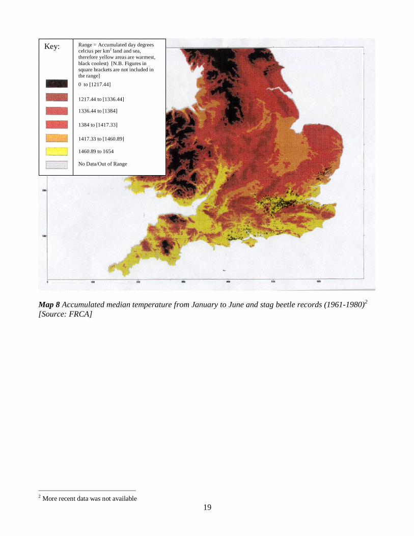
Map 8 Accumulated temperature from January to June and stag beetle
records [Source: FRCA]……………………………………………. 19
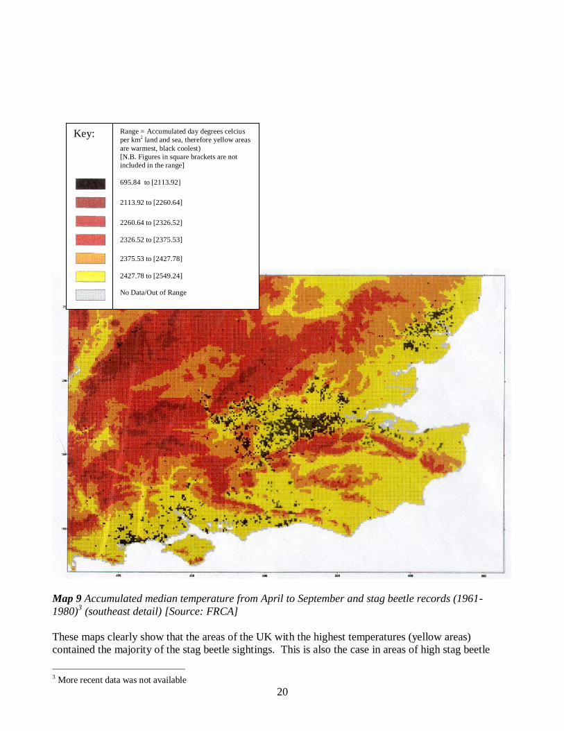
Map 9 Accumulated temperature from April to September and stag beetle
records (southeast detail) [Source: FRCA]………………………… 20
Map 10 Major soil groups of southeast England overlaid with major rivers
and stag beetle sightings……………………………………………. 22
Map 11 The main outcrops of Cretaceous rocks in Britain with stag beetle
records[Source: Ager 1975]………………………………………… 25
Map 12 Accumulated average annual rainfall(1941-1970) and stag beetle
1 More recent data was not available
vi
sightings [Source: FRCA/Meteorological Office]…………………. 27
Map 13 Map of stag beetle records in Greater London (Stag beetles present in
10 km square)………………………………………………………. 29
* * * * * * * * * * * * * * * * * * * * * * * * * * * * * * * * * * * *
Graph 1 Number of male and female stag beetles reported per month……… 9
Graph 2 Number of stag beetles reported per day…………………………… 9
Graph 3 Average monthly air temperature in 1998 and the number of male
and female stag beetles seen in flight per month…………………… 11
Graph 4 Air temperature against number of stag beetles reported per month
[Source: Meteorological Office’s website]…………………………….. 21
Graph 5 Monthly rainfall and numbers of stag beetles reported per month
[Source: Meteorological Office]……………………………………. 26
* * * * * * * * * * * * * * * * * * * * * * * * * * * * * * * * * * * *
Table 1 Number of stag beetle records from each county.………………….. 8
Table 2 Type of stag beetle records (showing what the beetles were doing
when found)…………………………………………………………………. 10
Table 3 Types of dead wood most commonly associated with stag beetle
Records………………………………………………………………….. 12
Table 4 Number of male and female records on the periphery of the stag
beetles’ range………………………………………………………… 14
Table 5 Stag beetle sightings in different habitats using CIS……...………… 15
Table 6 Stag beetle sightings in different habitats using Recorder………….. 16
Table 7 Temperature and rainfall data for June 1990 to 2000 inclusive……. 26
vii
PREFACE
This survey has been of immense value in furthering our understanding of the ecology
of this species. It has highlighted the areas in which the insect most frequently occurs
and has suggested that there are a number of population ‘hotspots’ for it. Our task
now is to understand the reasons for these hotspots and to document the biology and
ecology of the beetle within them.
Some most interesting facts have emerged and these include the tendency for the
beetle to be associated with urban areas. Indeed, the majority of records seem to
come from this type of habitat. In some ways this is surprising, given the requirement
of the larvae for buried dead wood - one would have thought that this type of habitat
would most commonly be found in large, densely wooded areas. In another way, it is
most encouraging, as it gives us a real chance to influence the provision of habitat and
to enhance the long-term conservation needs of the beetle.
The survey has identified the main mortality factors of the species and shows that
many die as road casualties. This is clearly another feature of its urban lifestyle, but it
also sheds some light on its dispersal ability, another feature we must understand if
we are to enhance its population size. The insect also appears to be associated with
soil overlying particular geological strata, for example, it does not appear to be
associated with chalk. It is likely that this reflects the habitat requirements of the
subterranean larvae.
In summary, this survey has been an unqualified success. It has given us much useful
information on the current status of the insect and has set the agenda for research in
the next few years.
Dr Alan Gange
School of Biological Sciences,
Royal Holloway University of London,
October 2000

1
CHAPTER 1 INTRODUCING THE STAG BEETLE
The stag beetle, Lucanus cervus (L.) 1767, is Britain's largest and most striking terrestrial beetle. It
belongs to the order Coleoptera and the family Lucanidae. There are between 800 and 1,250 species in
the Lucanidae family worldwide but only three occur in Britain, one of which is the stag beetle. The
other two species are Dorcus parallelipidedus (L.) (the Lesser stag beetle) and Sinodendron
cylindricum (L.).
Appearance
Males can be more than 70 mm in length while females are generally smaller, usually 40-50 mm
(Figure 1). The males have large, stag-like ‘antlers’ that give the species its common name, which are,
in fact, greatly enlarged lower mandibles. In both sexes, the wing cases are a characteristic shiny,
chestnut brown colour (as are the male’s antlers) and the head and thorax are shiny black.
Figure 1 Male (left) and Female (right) stag beetles [Source:Colin Hawes, Suffolk Naturalists’
Society]
Life cycle
The stag beetle has a long life cycle of up to eight years during which it goes through four life stages;
the egg, the larva, the pupa and the imago (the adult stag beetle). In late summer, females lay small,
round eggs near or within dead wood 30-50 cm below ground. These quickly develop into horseshoe-
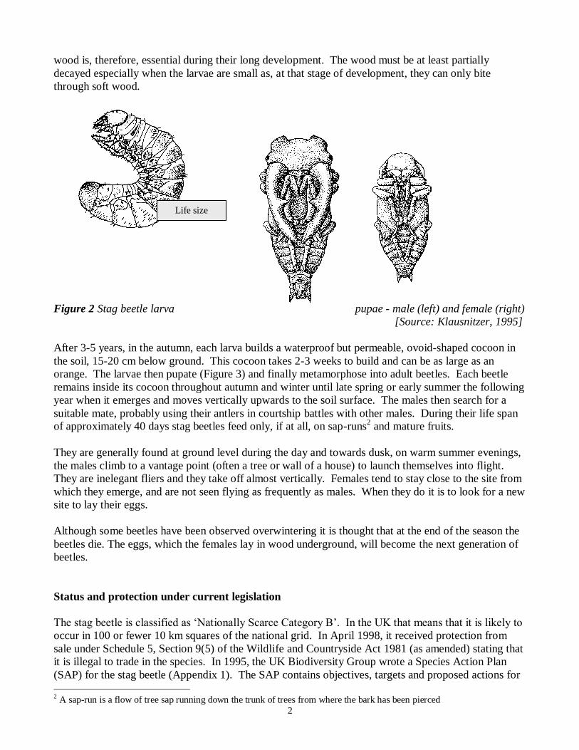
shaped larvae (Figure 2). The larvae, which can be 10-11 cm in length, are cream in colour with brown
heads and they live underground, feeding on decaying dead wood for at least three years. It is thought
that they can eat as much as 250 cm3 of dead wood every month
1. A stable and secure supply of dead
1 (they may also eat particles of humus and plant root hairs)
Life size
2
wood is, therefore, essential during their long development. The wood must be at least partially
decayed especially when the larvae are small as, at that stage of development, they can only bite
through soft wood.
Figure 2 Stag beetle larva Figure 3 Stag beetle pupae - male (left) and female (right)
[Source: Klausnitzer, 1995]
After 3-5 years, in the autumn, each larva builds a waterproof but permeable, ovoid-shaped cocoon in
the soil, 15-20 cm below ground. This cocoon takes 2-3 weeks to build and can be as large as an
orange. The larvae then pupate (Figure 3) and finally metamorphose into adult beetles. Each beetle
remains inside its cocoon throughout autumn and winter until late spring or early summer the following
year when it emerges and moves vertically upwards to the soil surface. The males then search for a
suitable mate, probably using their antlers in courtship battles with other males. During their life span
of approximately 40 days stag beetles feed only, if at all, on sap-runs2 and mature fruits.
They are generally found at ground level during the day and towards dusk, on warm summer evenings,
the males climb to a vantage point (often a tree or wall of a house) to launch themselves into flight.
They are inelegant fliers and they take off almost vertically. Females tend to stay close to the site from
which they emerge, and are not seen flying as frequently as males. When they do it is to look for a new
site to lay their eggs.
Although some beetles have been observed overwintering it is thought that at the end of the season the
beetles die. The eggs, which the females lay in wood underground, will become the next generation of
beetles.
Status and protection under current legislation
The stag beetle is classified as ‘Nationally Scarce Category B’. In the UK that means that it is likely to
occur in 100 or fewer 10 km squares of the national grid. In April 1998, it received protection from
sale under Schedule 5, Section 9(5) of the Wildlife and Countryside Act 1981 (as amended) stating that
it is illegal to trade in the species. In 1995, the UK Biodiversity Group wrote a Species Action Plan
(SAP) for the stag beetle (Appendix 1). The SAP contains objectives, targets and proposed actions for
2 A sap-run is a flow of tree sap running down the trunk of trees from where the bark has been pierced
Life size
3
stag beetle conservation. In 1998, the People’s Trust for Endangered Species became the Lead Partner
in implementing the SAP with English Nature as the Contact Point.
Collaboration with other organisations
The People’s Trust is working on the stag beetle with a number of co-partners including English Nature
(EN), the Joint Nature Conservation Committee (JNCC), the Forestry Commission, Suffolk
Naturalists’ Society, Colchester Museums, the Natural History Museum, London Wildlife Trust, the
Corporation of London, Berks, Bucks and Oxon Wildlife Trust, Hampshire Wildlife Trust, the London
Borough of Bromley, universities and other wildlife trusts.
4
CHAPTER 2 METHOD
The 1998 National Stag Beetle Survey
A high profile, UK-wide National Stag Beetle Survey was carried out in 1998 to enable the collection
of as much data as possible from across the whole of the UK. Members of the public were encouraged
to report all sightings of stag beetles, including information such as, colour, sex, time of sighting,
precise place and date of sighting and anything else of potential interest. People were encouraged to
include a photograph (or the specimen if the beetle was found dead).
The aims of the survey were:
to establish the current UK distribution of stag beetles and identify any changes from its
historical range,
to increase public awareness of the stag beetle and its conservation needs,
to identify factors affecting its distribution, and
to make suitable recommendations for stag beetle conservation and ensure their
implementation.
The National Stag Beetle Survey was launched at the beginning of the flight season in May 1998 in
Richmond Park by Mr Michael Meacher, the Minister for the Environment. Over 100,000 public
information leaflets were distributed to schools, Wildlife Trusts, naturalist societies, museums, ecology
centres and members of the public upon request. The leaflet gave information on the known
distribution of the beetle, how to recognise it and how to help conserve it. It also contained a survey
form to complete and return to PTES or the appropriate local Wildlife Trust. A leaflet containing
advice on how to manage land appropriately for stag beetles was written and was sent to specialists and
land managers nationwide.
Throughout the year, articles and reports appeared in newspapers and magazines, including BBC
Wildlife, the National Trust magazine, The Times, The Telegraph and the RSPB and BTO members'
magazines. The survey also received extensive coverage on radio and television including the Today
programme on Radio 4 and Blue Peter as well as numerous local radio and television programmes.
Mileta Tog 24 became the Champion of the stag beetle as part of the government’s initiative to involve
companies and industries in environmental and conservation issues.
How the data was analysed
Data was stored on the widely used environmental recording database package, Recorder (version
3.12b) which also provided descriptive statistics about the data.
The data was imported into JNCC’s Countryside Information System (CIS) version 5.4. This package
enabled us to map the presence or absence of stag beetles in every 1 km grid square across the UK and
allowed more detailed analysis of the data. Data was also analysed using Microsoft Excel. Multiple
regression analysis and chi-squared tests were used where appropriate to show the relationship between
the beetle’s density and different soil types and were carried out by Bob Smith at the Durrell Institute
for Conservation and Ecology (DICE) at the University of Kent.
5
CHAPTER 3 RESULTS OF THE SURVEY
Distribution
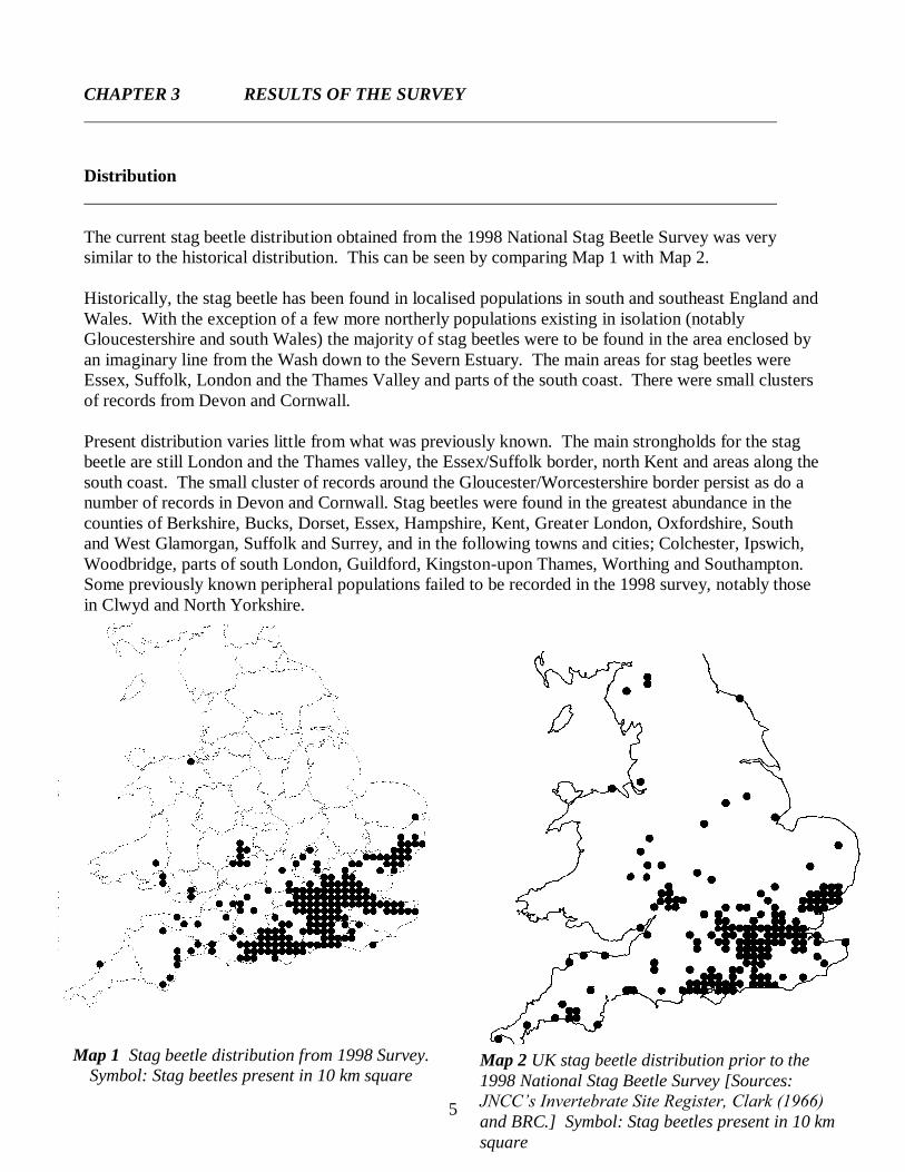
The current stag beetle distribution obtained from the 1998 National Stag Beetle Survey was very
similar to the historical distribution. This can be seen by comparing Map 1 with Map 2.
Historically, the stag beetle has been found in localised populations in south and southeast England and
Wales. With the exception of a few more northerly populations existing in isolation (notably
Gloucestershire and south Wales) the majority of stag beetles were to be found in the area enclosed by
an imaginary line from the Wash down to the Severn Estuary. The main areas for stag beetles were
Essex, Suffolk, London and the Thames Valley and parts of the south coast. There were small clusters
of records from Devon and Cornwall.
Present distribution varies little from what was previously known. The main strongholds for the stag
beetle are still London and the Thames valley, the Essex/Suffolk border, north Kent and areas along the
south coast. The small cluster of records around the Gloucester/Worcestershire border persist as do a
number of records in Devon and Cornwall. Stag beetles were found in the greatest abundance in the
counties of Berkshire, Bucks, Dorset, Essex, Hampshire, Kent, Greater London, Oxfordshire, South
and West Glamorgan, Suffolk and Surrey, and in the following towns and cities; Colchester, Ipswich,
Woodbridge, parts of south London, Guildford, Kingston-upon Thames, Worthing and Southampton.
Some previously known peripheral populations failed to be recorded in the 1998 survey, notably those
in Clwyd and North Yorkshire.
Map 2 UK stag beetle distribution prior to the
1998 National Stag Beetle Survey [Sources:
JNCC’s Invertebrate Site Register, Clark (1966)
and BRC.] Symbol: Stag beetles present in 10 km
square
Map 1 Stag beetle distribution from 1998 Survey.
Symbol: Stag beetles present in 10 km square
6
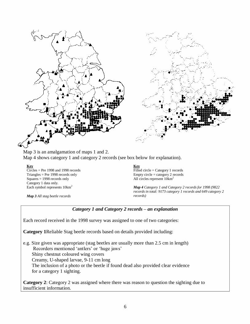
Map 3 is an amalgamation of maps 1 and 2.
Map 4 shows category 1 and category 2 records (see box below for explanation).
Category 1 and Category 2 records – an explanation
Each record received in the 1998 survey was assigned to one of two categories:
Category 1Reliable Stag beetle records based on details provided including:
e.g. Size given was appropriate (stag beetles are usually more than 2.5 cm in length)
Recorders mentioned „antlers‟ or „huge jaws‟
Shiny chestnut coloured wing covers
Creamy, U-shaped larvae, 9-11 cm long
The inclusion of a photo or the beetle if found dead also provided clear evidence
for a category 1 sighting.
Category 2: Category 2 was assigned where there was reason to question the sighting due to
insufficient information.
Key Circles = Pre 1998 and 1998 records
Triangles = Pre 1998 records only Squares = 1998 records only Category 1 data only. Each symbol represents 10km2
Map 3 All stag beetle records
Key Filled circle = Category 1 records
Empty circle = category 2 records All circles represent 10km2
Map 4 Category 1 and Category 2 records for 1998 (9822 records in total: 9173 category 1 records and 649 category 2 records)
7
There were records of sightings from some areas and yet no sightings at all in areas very close by, for
example, there were many records from Worthing and
yet none from neighbouring Brighton.
Traditionally, stag beetles have been associated with
forests and woods, such as Epping Forest. However, it
seems that nowadays one is just as likely to see the
beetles thriving in cities and city suburbs. In fact,
many more beetles were reported from urban areas
than rural ones. This could be because fewer people
were looking for them in the countryside, rather than
because stag beetles are fewer there (for this reason
abundance figures were not used in any statistical
analysis). Efforts will continue to collect more records
from rural areas.
Although the current stag beetle distribution has not
altered dramatically from the historical distribution
provided by JNCC, the total numbers of stag beetles
may be declining, even in stronghold areas. Many
people who submitted records noted that they had not
seen as many stag beetles in recent years as 5 - 10
years ago.
The beetles are still present in northern parts of the Isle
of Wight but there has been no evidence of a breeding
colony on the island. The records are clustered around
Cowes and Yarmouth suggesting that the beetles may
have reached the island via the ferry from Lymington
on the mainland, where there have been many reported
sightings. Alternatively, adults could have been blown
across the Solent by the wind.
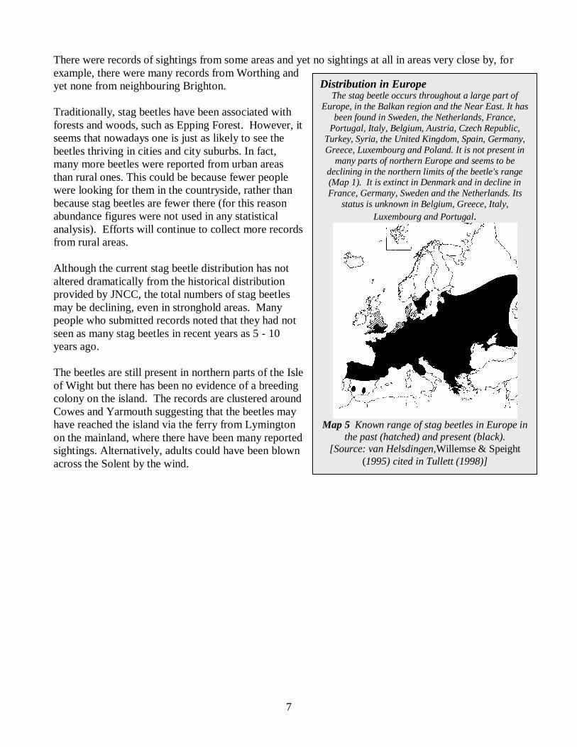
Distribution in Europe
The stag beetle occurs throughout a large part of
Europe, in the Balkan region and the Near East. It has
been found in Sweden, the Netherlands, France,
Portugal, Italy, Belgium, Austria, Czech Republic,
Turkey, Syria, the United Kingdom, Spain, Germany,
Greece, Luxembourg and Poland. It is not present in
many parts of northern Europe and seems to be
declining in the northern limits of the beetle's range (Map 1). It is extinct in Denmark and in decline in
France, Germany, Sweden and the Netherlands. Its
status is unknown in Belgium, Greece, Italy,
Luxembourg and Portugal.
Map 5 Known range of stag beetles in Europe in
the past (hatched) and present (black).
[Source: van Helsdingen,Willemse & Speight
(1995) cited in Tullett (1998)]
8
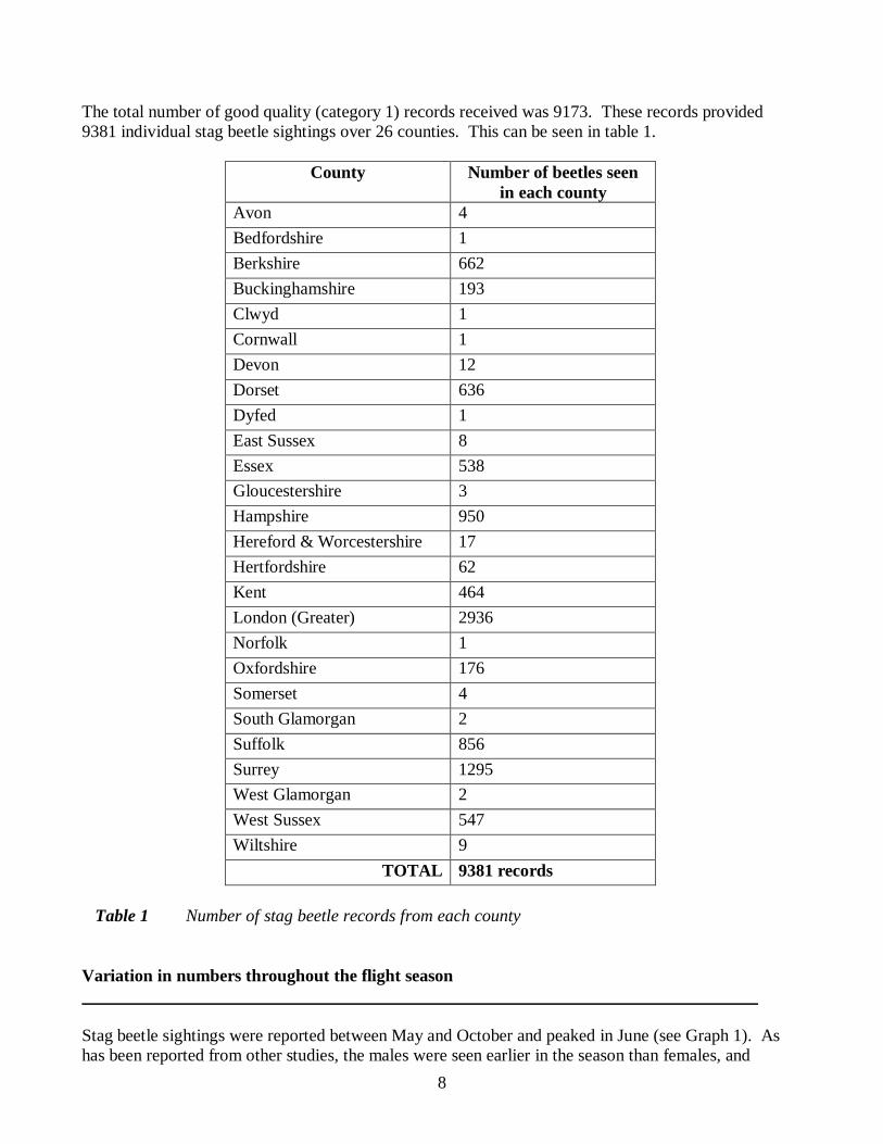
The total number of good quality (category 1) records received was 9173. These records provided
9381 individual stag beetle sightings over 26 counties. This can be seen in table 1.
County Number of beetles seen
in each county
Avon 4
Bedfordshire 1
Berkshire 662
Buckinghamshire 193
Clwyd 1
Cornwall 1
Devon 12
Dorset 636
Dyfed 1
East Sussex 8
Essex 538
Gloucestershire 3
Hampshire 950
Hereford & Worcestershire 17
Hertfordshire 62
Kent 464
London (Greater) 2936
Norfolk 1
Oxfordshire 176
Somerset 4
South Glamorgan 2
Suffolk 856
Surrey 1295
West Glamorgan 2
West Sussex 547
Wiltshire 9
TOTAL 9381 records
Table 1 Number of stag beetle records from each county
Variation in numbers throughout the flight season
Stag beetle sightings were reported between May and October and peaked in June (see Graph 1). As
has been reported from other studies, the males were seen earlier in the season than females, and
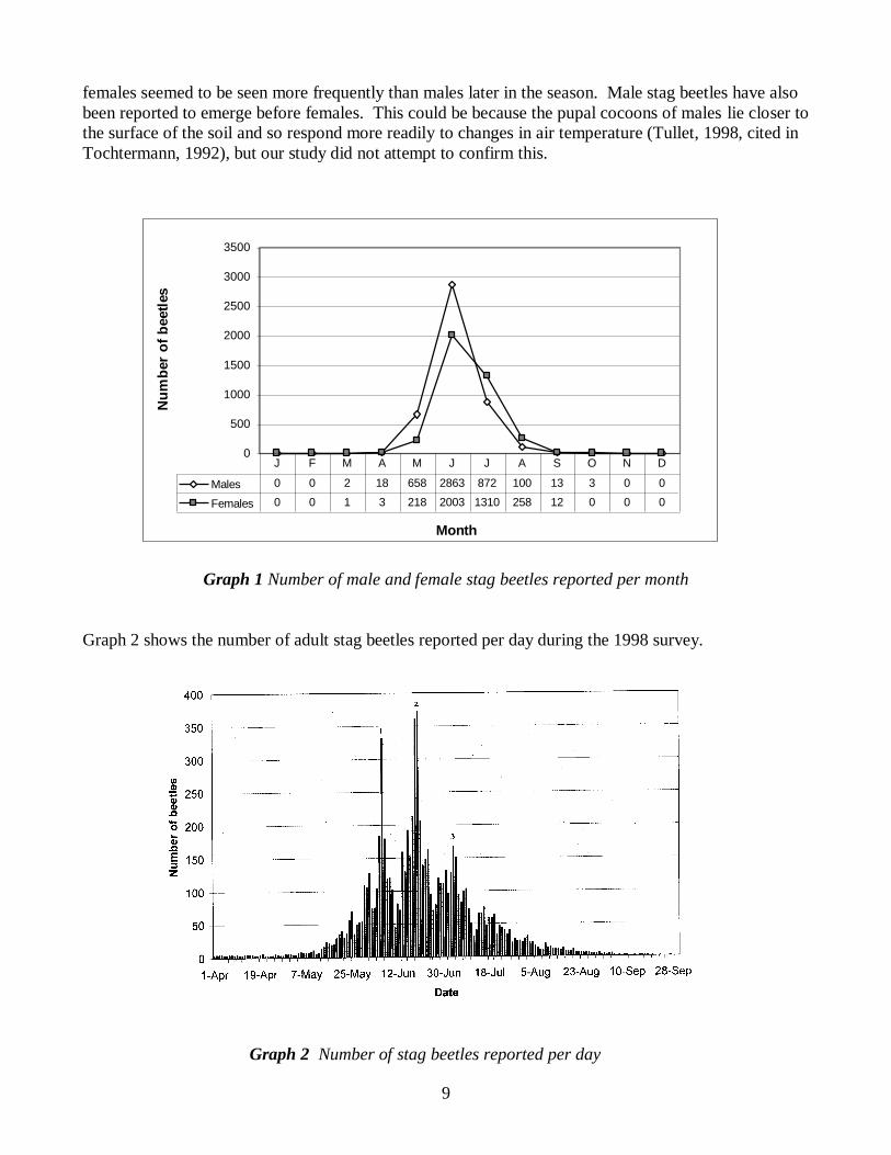
9
females seemed to be seen more frequently than males later in the season. Male stag beetles have also
been reported to emerge before females. This could be because the pupal cocoons of males lie closer to
the surface of the soil and so respond more readily to changes in air temperature (Tullet, 1998, cited in
Tochtermann, 1992), but our study did not attempt to confirm this.
Graph 1 Number of male and female stag beetles reported per month
Graph 2 shows the number of adult stag beetles reported per day during the 1998 survey.
0
500
1000
1500
2000
2500
3000
3500
Month
Nu
mb
er
of
beetl
es
Males 0 0 2 18 658 2863 872 100 13 3 0 0
Females 0 0 1 3 218 2003 1310 258 12 0 0 0
J F M A M J J A S O N D
Graph 2 Number of stag beetles reported per day
10
Most sightings were reported in June and early July with a peak on 20th June (373 records) when the
majority of beetles had emerged and many (especially males) were flying in search of a mate. The
beetles take advantage of the warm, dry June and July evenings. The sightings tailed off steadily
through July and August.
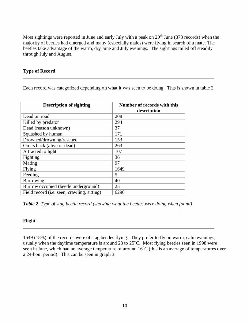
Type of Record
Each record was categorized depending on what it was seen to be doing. This is shown in table 2.
Description of sighting Number of records with this
description
Dead on road 208
Killed by predator 294
Dead (reason unknown) 37
Squashed by human 171
Drowned/drowning/rescued 153
On its back (alive or dead) 263
Attracted to light 107
Fighting 36
Mating 97
Flying 1649
Feeding 5
Burrowing 40
Burrow occupied (beetle underground) 25
Field record (i.e. seen, crawling, sitting) 6290
Table 2 Type of stag beetle record (showing what the beetles were doing when found)
Flight
1649 (18%) of the records were of stag beetles flying. They prefer to fly on warm, calm evenings,
usually when the daytime temperature is around 23 to 25oC. Most flying beetles seen in 1998 were
seen in June, which had an average temperature of around 16oC (this is an average of temperatures over
a 24-hour period). This can be seen in graph 3.
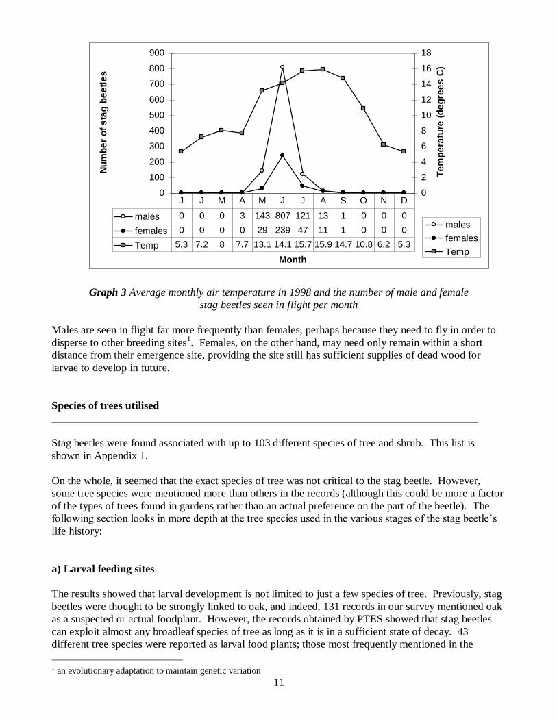
11
Graph 3 Average monthly air temperature in 1998 and the number of male and female
stag beetles seen in flight per month
Males are seen in flight far more frequently than females, perhaps because they need to fly in order to
disperse to other breeding sites1. Females, on the other hand, may need only remain within a short
distance from their emergence site, providing the site still has sufficient supplies of dead wood for
larvae to develop in future.
Species of trees utilised
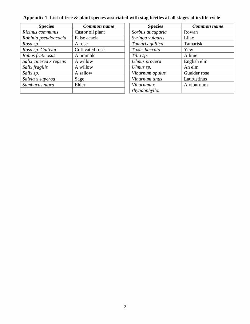
Stag beetles were found associated with up to 103 different species of tree and shrub. This list is
shown in Appendix 1.
1 an evolutionary adaptation to maintain genetic variation
On the whole, it seemed that the exact species of tree was not critical to the stag beetle. However,
some tree species were mentioned more than others in the records (although this could be more a factor
of the types of trees found in gardens rather than an actual preference on the part of the beetle). The
following section looks in more depth at the tree species used in the various stages of the stag beetle‟s
life history:
a) Larval feeding sites
The results showed that larval development is not limited to just a few species of tree. Previously, stag
beetles were thought to be strongly linked to oak, and indeed, 131 records in our survey mentioned oak
as a suspected or actual foodplant. However, the records obtained by PTES showed that stag beetles
can exploit almost any broadleaf species of tree as long as it is in a sufficient state of decay. 43
different tree species were reported as larval food plants; those most frequently mentioned in the
0
100
200
300
400
500
600
700
800
900
Month
Nu
mb
er
of
sta
g b
ee
tle
s
0
2
4
6
8
10
12
14
16
18
Te
mp
era
ture
(d
eg
ree
s C
)
males
females
Temp
males 0 0 0 3 143 807 121 13 1 0 0 0
females 0 0 0 0 29 239 47 11 1 0 0 0
Temp 5.3 7.2 8 7.7 13.1 14.1 15.7 15.9 14.7 10.8 6.2 5.3
J J M A M J J A S O N D

12
records were apple, ash, cherry and oak. Other species mentioned included pine, pear, maple, elm,
horse-chestnut and silver birch. Appendix 2 shows the full species lists.
b) Female oviposition sites (sites where females lay eggs)
A total of 34 different tree species were reported as suspected or confirmed oviposition sites; those
most frequently mentioned in the records were: oak, cherry, elm, pear, beech and ash. The full list of
species is shown in Appendix 3.
c) Tree perching sites (trees on which stag beetles were found)
148 of the total records mentioned that beetles were found sitting or „perching‟ on trees. In total, 72
different tree species were recorded. The full list of species is shown in Appendix 4.
d) Adult feeding
Only five records mentioned adults feeding. These reports were a stag beetle 'feasting on the fungus
growing at the bottom of the garden', 'feeding on pear core', „eating a rotten banana‟ and 'eating a laurel
leaf'. The last record described apple as being a food source for a stag beetle. Although it is thought
that the beetles may feed on sap runs, there were no such records in our survey.
Function of wood upon which the beetles were found
The survey showed that, on the whole, it didn‟t matter what form the deadwood took or what purpose it
served provided it was in contact with the ground (Table 3). Tree stumps were noted as being the type
of dead wood used most frequently. Log piles, fence posts, roots and wood chippings were also
frequently mentioned. There was a bias towards broadleaved wood with conifer species rarely
mentioned. A number of records of stag beetles (and larvae) came from compost heaps.
Type of dead wood
the beetle was
found on
Number of records that mentioned stag
beetles associated with this type
of dead wood
Fence posts 31
Tree stumps 329
Roots 25
Log piles 146
Wood chippings 19
Table 3 Type of dead wood most commonly associated with stag beetle records
Mating
13
Mating stag beetle pairs were noted in 97 records. Some males were attracted to crushed females on
roads or pavements, as well as to live females, possibly attracted by a female pheromone.
Predators and other hazards
The most significant stag beetle predators were animals found in urban areas. The large, slow-moving
beetles are easy prey for animals such as magpies, sparrows, cats, foxes, squirrels, bats and frogs.
People accounted for many stag beetle deaths. There were many reports of beetles squashed on
pavements and roads. Appendix 5 shows a full list of the animals associated with the stag beetle at the
time of sighting.
294 beetles were found killed by successful predators, most commonly, magpies, cats, foxes, humans
and blackbirds. The most frequently mentioned unsuccessful predators were cat and sparrow.
There were reports of stag beetle 'massacres' - numerous stag beetle carcasses found, often on lawns,
after attacks by birds, especially magpies. Once the magpies found the emergence site it seemed that
they returned time and again to the same spot to kill and eat the “soft fleshly” parts of adult beetles.
153 records of drowning or drowned stag beetles were received.
263 records were of stag beetles found on their backs, either alive or dead (they have difficulty righting
themselves once upside down).
There were 36 reports of male stag beetles fighting, often with a female nearby. It is not known
whether these fights were fatal to either party.
Singleton records and records on the periphery of the range
Records of a single stag beetle in a 1km square were called „singleton‟ records. 82% of all singleton
records were in suburban areas. [These beetles probably do not represent a significant population but
instead are more likely to have been beetles that had dispersed from their emergence site in search of a
mate or possibly food.] The singleton records in sparsely (human) populated areas may be part of
significant populations. Further research is needed to discover whether this is so.
Records on the periphery of the stag beetle's range, or „outlying records‟, were those records that were
received from outside the stag beetle‟s current strongholds. These sightings could represent significant
or struggling populations.
If both males and females are present in an outlying area then it is more likely to be a breeding site. If
beetles of only one sex were found, then the possibility that these were lone individuals seeking mates
or oviposition sites, or that they were misidentifications, is greatly increased.
Table 4 lists the main records from peripheral sites. The records include category 2 beetles (i.e. records
of dubious accuracy).
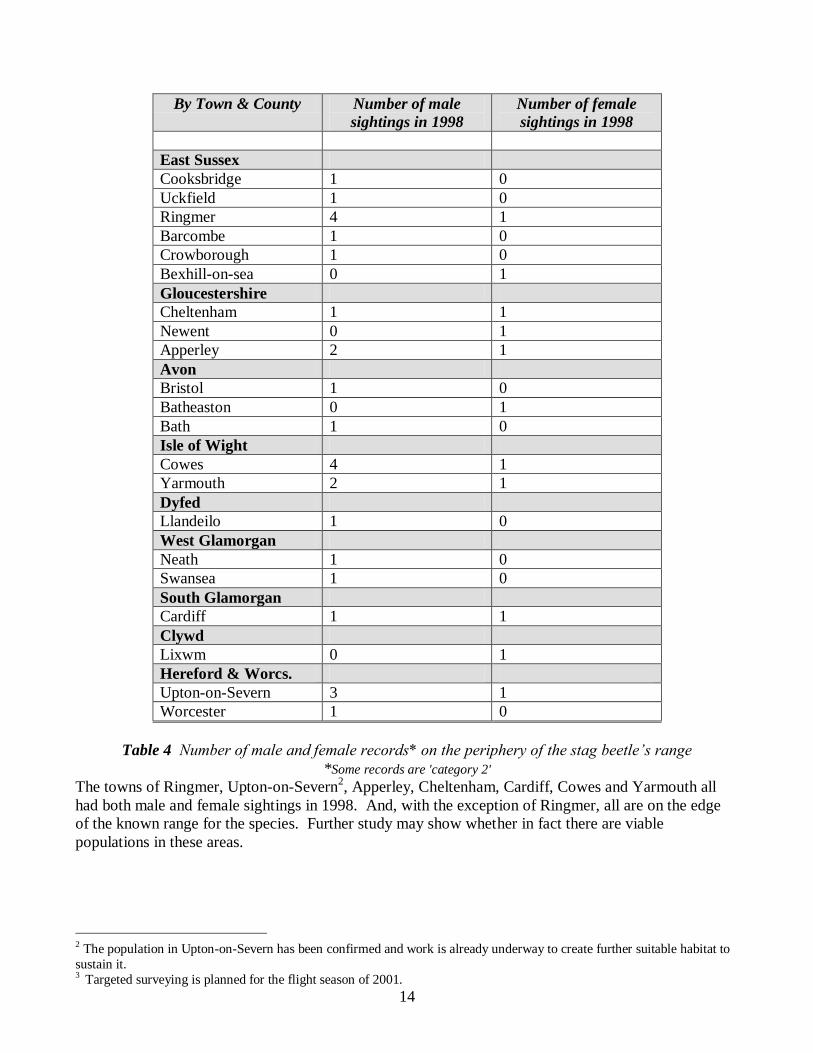
14
By Town & County Number of male
sightings in 1998
Number of female
sightings in 1998
East Sussex
Cooksbridge 1 0
Uckfield 1 0
Ringmer 4 1
Barcombe 1 0
Crowborough 1 0
Bexhill-on-sea 0 1
Gloucestershire
Cheltenham 1 1
Newent 0 1
Apperley 2 1
Avon
Bristol 1 0
Batheaston 0 1
Bath 1 0
Isle of Wight
Cowes 4 1
Yarmouth 2 1
Dyfed
Llandeilo 1 0
West Glamorgan
Neath 1 0
Swansea 1 0
South Glamorgan
Cardiff 1 1
Clywd
Lixwm 0 1
Hereford & Worcs.
Upton-on-Severn 3 1
Worcester 1 0
Table 4 Number of male and female records* on the periphery of the stag beetle’s range
*Some records are 'category 2'
The towns of Ringmer, Upton-on-Severn2, Apperley, Cheltenham, Cardiff, Cowes and Yarmouth all
had both male and female sightings in 1998. And, with the exception of Ringmer, all are on the edge
of the known range for the species. Further study may show whether in fact there are viable
populations in these areas.
2 The population in Upton-on-Severn has been confirmed and work is already underway to create further suitable habitat to
sustain it. 3 Targeted surveying is planned for the flight season of 2001.
15
CHAPTER 4 POSSIBLE FACTORS AFFECTING DISTRIBUTION
The requirements of a species at every stage of its life cycle will ultimately determine its geographical
distribution. Relevant and useful conservation measures can only be applied once these requirements
are fully understood. Habitat availability, air temperature, soil, geology and rainfall were each looked
at as possible factors affecting stag beetle distribution. In addition, both inter- and intra-specific
competition were considered.
Habitat availability
The stag beetle relies upon dead wood at every stage of its life cycle. Supplies of dead wood have been
diminishing in the UK for three main reasons and they are as follows:
1. The trend towards 'clean and tidy' gardens means that many garden owners choose to quickly
remove rotten trees, tree stumps or old roots from their gardens.
2. Dead wood is not being created at the same rate as it was in the past because there are far fewer
trees in the UK than there used to be. The beetles took advantage of diseased Dutch Elm trees
and wood created by natural phenomena, such as the great storm of 1987. These sources of
wood are now drying up.
3. Councils and landowners feel compelled to remove dead trees in the interests of public safety (in
many cases the trees themselves may not actually be dangerous).
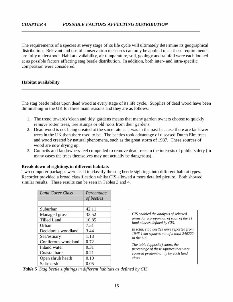
Break down of sightings in different habitats
Two computer packages were used to classify the stag beetle sightings into different habitat types.
Recorder provided a broad classification whilst CIS allowed a more detailed picture. Both showed
similar results. These results can be seen in Tables 3 and 4.
Land Cover Class Percentage
of beetles
Suburban 42.11
Managed grass 33.52
Tilled Land 10.85
Urban 7.51
Deciduous woodland 3.44
Sea/estuary 1.18
Coniferous woodland 0.72
Inland water 0.31
Coastal bare 0.21
Open shrub heath 0.10
Saltmarsh 0.05
Table 5 Stag beetle sightings in different habitats as defined by CIS
CIS enabled the analysis of selected
areas for a proportion of each of the 11
land classes defined by CIS.
In total, stag beetles were reported from
1945 1 km squares out of a total 240222 in the UK.
The table (opposite) shows the
percentage of these squares that were
covered predominantly by each land
class.
16
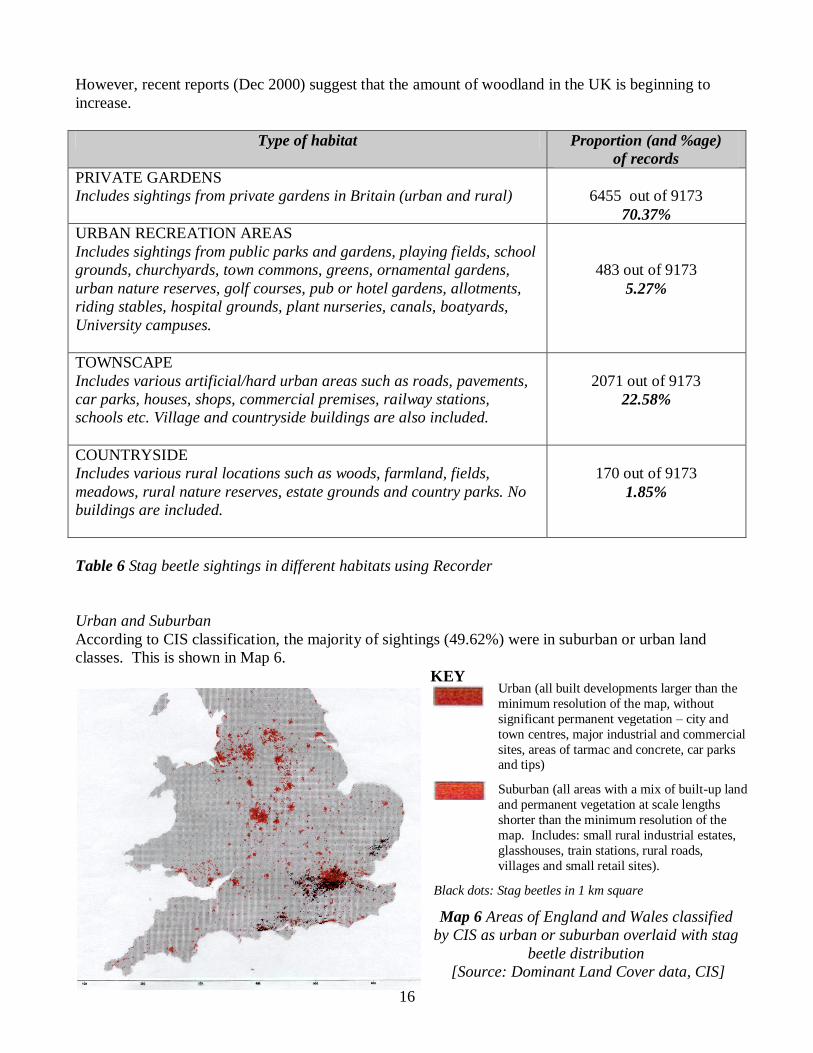
However, recent reports (Dec 2000) suggest that the amount of woodland in the UK is beginning to
increase.
Type of habitat Proportion (and %age)
of records
PRIVATE GARDENS
Includes sightings from private gardens in Britain (urban and rural)
6455 out of 9173
70.37%
URBAN RECREATION AREAS
Includes sightings from public parks and gardens, playing fields, school
grounds, churchyards, town commons, greens, ornamental gardens,
urban nature reserves, golf courses, pub or hotel gardens, allotments,
riding stables, hospital grounds, plant nurseries, canals, boatyards,
University campuses.
483 out of 9173
5.27%
TOWNSCAPE
Includes various artificial/hard urban areas such as roads, pavements,
car parks, houses, shops, commercial premises, railway stations,
schools etc. Village and countryside buildings are also included.
2071 out of 9173
22.58%
COUNTRYSIDE
Includes various rural locations such as woods, farmland, fields,
meadows, rural nature reserves, estate grounds and country parks. No
buildings are included.
170 out of 9173
1.85%
Table 6 Stag beetle sightings in different habitats using Recorder
Urban and Suburban
According to CIS classification, the majority of sightings (49.62%) were in suburban or urban land
classes. This is shown in Map 6.
KEY
Black dots: Stag beetles in 1 km square
Map 6 Areas of England and Wales classified
by CIS as urban or suburban overlaid with stag
beetle distribution
[Source: Dominant Land Cover data, CIS]
Urban (all built developments larger than the
minimum resolution of the map, without
significant permanent vegetation – city and
town centres, major industrial and commercial
sites, areas of tarmac and concrete, car parks and tips)
Suburban (all areas with a mix of built-up land
and permanent vegetation at scale lengths
shorter than the minimum resolution of the
map. Includes: small rural industrial estates,
glasshouses, train stations, rural roads,
villages and small retail sites).

17
Recorder showed similar results to those from CIS. Beetles in urban and suburban areas were making
use of remaining deadwood. Historically, there was a substantial amount of deadwood available in and
around towns including old tree stumps in gardens, allotments and parks, rotting fence posts and log
piles.
Suitable habitat in towns is generally fragmented, separated by roads, pavements and buildings. The
many town sightings from roads and pavements were probably beetles attempting to disperse in search
of fresh habitat and mates.
Gardens, both in urban and rural areas, are therefore important providers (and potential
providers) of suitable habitat for the species in the future. Gardeners and landowners should be
made aware of the benefits to stag beetles and other wildlife both of not removing dead wood and
of creating suitable habitat, e.g. by building partially buried log piles, leaving them undisturbed
and replenishing them by putting further wood carefully on top at a later date as necessary.
Woodlands/Rural Areas
Using CIS only 4.16% of 1km squares with sightings were in the woodland category. Recorder
showed that only 1.85% of sightings were from rural areas. Many parts of the countryside undoubtedly
have a ready supply of dead wood suitable as larval foodstuff. Since woodland is known to be good
stag beetle habitat, it is probable that there are viable populations in some of these areas, despite no
records being received. This is an area that needs further investigation.
NOTE: The custom-made RECORDER codes and the CIS land classes are based on very different
information. The RECORDER codes were defined in-house and each stag beetle record that was
entered onto the database was assigned a habitat code according to the location given by the recorder.
The CIS land classes are based on a general UK survey to determine the main land use in each 1km
square. The resulting habitat statistics from the two sources are therefore not directly comparable.
18
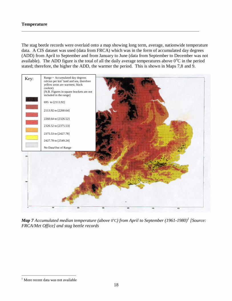
Temperature
The stag beetle records were overlaid onto a map showing long term, average, nationwide temperature
data. A CIS dataset was used (data from FRCA) which was in the form of accumulated day degrees
(ADD) from April to September and from January to June (data from September to December was not
available). The ADD figure is the total of all the daily average temperatures above 0oC in the period
stated; therefore, the higher the ADD, the warmer the period. This is shown in Maps 7,8 and 9.
Map 7 Accumulated median temperature (above 0oC) from April to September (1961-1980)1 [Source:
FRCA/Met Office] and stag beetle records
1 More recent data was not available
Key:
Range = Accumulated day degrees
celcius per km2 land and sea, therefore
yellow areas are warmest, black
coolest)
[N.B. Figures in square brackets are not
included in the range]
695 to [2113.92]
2113.92 to [2260.64]
2260.64 to [2326.52]
2326.52 to [2375.53]
2375.53 to [2427.78]
2427.78 to [2549.24]
No Data/Out of Range
19
Map 8 Accumulated median temperature from January to June and stag beetle records (1961-1980)2
[Source: FRCA]
2 More recent data was not available
Key:
Range = Accumulated day degrees
celcius per km2 land and sea,
therefore yellow areas are warmest,
black coolest) [N.B. Figures in
square brackets are not included in
the range]
0 to [1217.44]
1217.44 to [1336.44]
1336.44 to [1384]
1384 to [1417.33]
1417.33 to [1460.89]
1460.89 to 1654
No Data/Out of Range
20
Map 9 Accumulated median temperature from April to September and stag beetle records (1961-
1980)3 (southeast detail) [Source: FRCA]
These maps clearly show that the areas of the UK with the highest temperatures (yellow areas)
contained the majority of the stag beetle sightings. This is also the case in areas of high stag beetle
3 More recent data was not available
Key:
Range = Accumulated day degrees celcius
per km2 land and sea, therefore yellow areas
are warmest, black coolest)
[N.B. Figures in square brackets are not
included in the range]
695.84 to [2113.92]
2113.92 to [2260.64]
2260.64 to [2326.52]
2326.52 to [2375.53]
2375.53 to [2427.78]
2427.78 to [2549.24]
No Data/Out of Range
21
concentration as well as in areas on the edge of its range, such in south Wales, parts of the southwest,
and the cluster of records on the Gloucestershire /Worcestershire border.
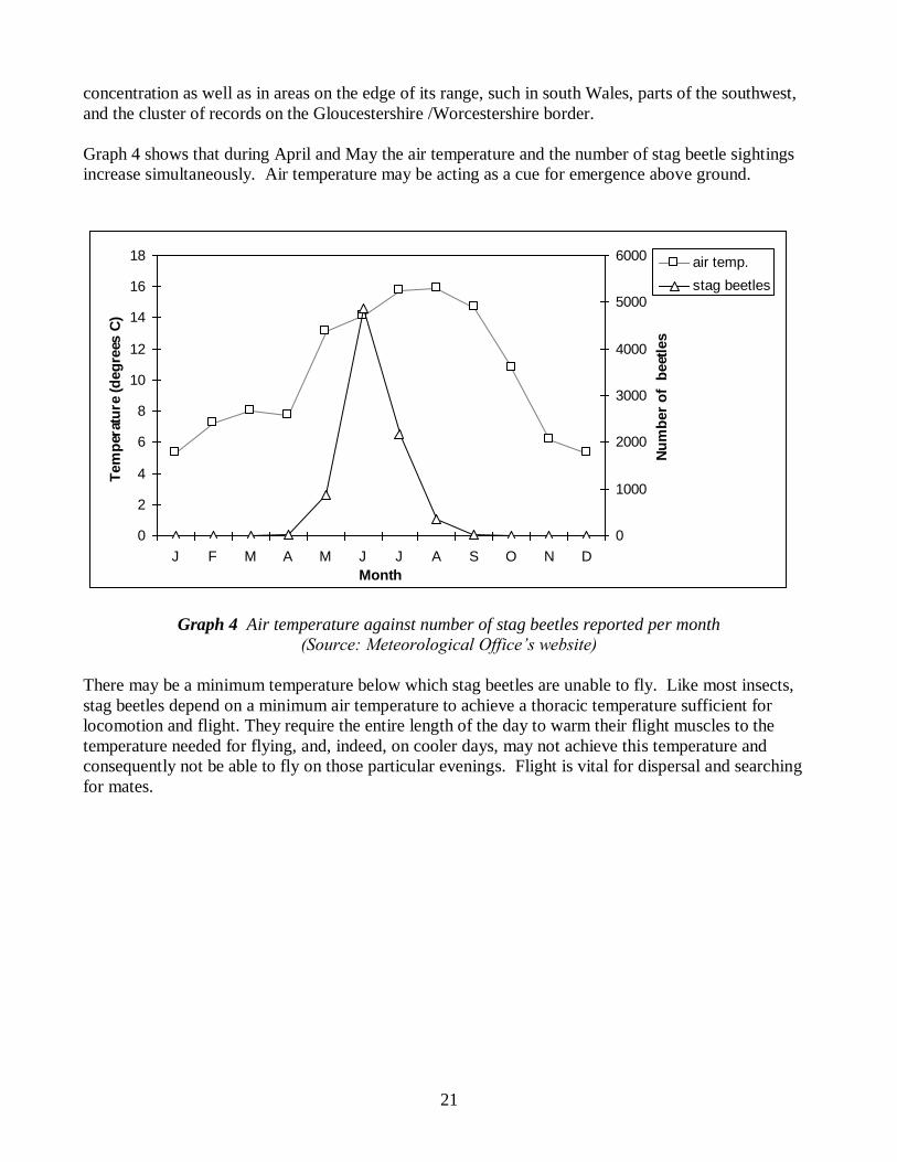
Graph 4 shows that during April and May the air temperature and the number of stag beetle sightings
increase simultaneously. Air temperature may be acting as a cue for emergence above ground.
Graph 4 Air temperature against number of stag beetles reported per month
(Source: Meteorological Office’s website)
There may be a minimum temperature below which stag beetles are unable to fly. Like most insects,
stag beetles depend on a minimum air temperature to achieve a thoracic temperature sufficient for
locomotion and flight. They require the entire length of the day to warm their flight muscles to the
temperature needed for flying, and, indeed, on cooler days, may not achieve this temperature and
consequently not be able to fly on those particular evenings. Flight is vital for dispersal and searching
for mates.
0
2
4
6
8
10
12
14
16
18
J F M A M J J A S O N D
Month
Tem
per
atu
re (
deg
rees
C)
0
1000
2000
3000
4000
5000
6000
Nu
mb
er
of
beet
les
air temp.
stag beetles
22
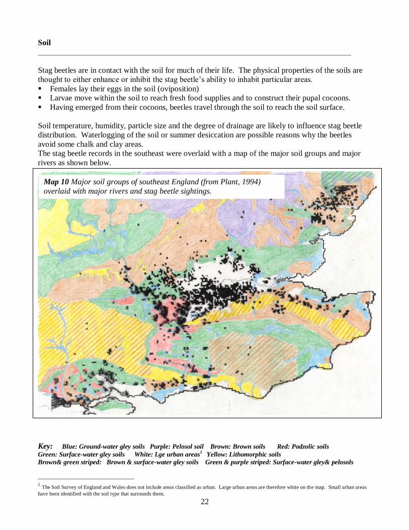
Soil
Stag beetles are in contact with the soil for much of their life. The physical properties of the soils are
thought to either enhance or inhibit the stag beetle’s ability to inhabit particular areas.
Females lay their eggs in the soil (oviposition)
Larvae move within the soil to reach fresh food supplies and to construct their pupal cocoons.
Having emerged from their cocoons, beetles travel through the soil to reach the soil surface.
Soil temperature, humidity, particle size and the degree of drainage are likely to influence stag beetle
distribution. Waterlogging of the soil or summer desiccation are possible reasons why the beetles
avoid some chalk and clay areas.
The stag beetle records in the southeast were overlaid with a map of the major soil groups and major
rivers as shown below.
Key: Blue: Ground-water gley soils Purple: Pelosol soil Brown: Brown soils Red: Podzolic soils
Green: Surface-water gley soils White: Lge urban areas1 Yellow: Lithomorphic soils
Brown& green striped: Brown & surface-water gley soils Green & purple striped: Surface-water gley& pelosols
1 The Soil Survey of England and Wales does not include areas classified as urban. Large urban areas are therefore white on the map. Small urban areas
have been identified with the soil type that surrounds them.
Map 10 Major soil groups of southeast England (from Plant, 1994)
overlaid with major rivers and stag beetle sightings.
23
Map 8 shows that stag beetles occur on podzolic, brown and ground-water gley soils in the southeast
and that they very rarely occur on surface-water gley soils (which become easily waterlogged in the
upper layers) or on lithomorphic or pelosol soils (both calcareous/chalky). Waterlogged and chalky
soils would probably be difficult for stag beetles to burrow into. If present, they might also be
vulnerable to drowning.
Results of a multiple regression analysis of soil data from CIS 2 seem to show that beetles actively
avoid lithomorphic and man-made soils3 (see Appendix 6). A few of the main points which are
illustrated on Map 10, include:
A large proportion of south Essex and neighbouring Hertfordshire is made up of surface-water gley
soil, which was virtually devoid of sightings.
There is a persisting cluster of stag beetle records in north Essex and south Suffolk4. This cluster
lies on predominantly brown soil and ground-water gley.
No records were received from the area that begins just north of Ipswich. The soils in this area are
pelosols and surface-water gleys.
The large amount of chalky pelosols present in the west of Essex seems to be preventing stag
beetles from spreading into that part of the county.
The North and South Downs are made up of chalky soils (brown and lithomorphic) and in these
areas stag beetles are rare. The Weald, the area between the North and South Downs containing
much of East Sussex and Kent, is also largely devoid of stag beetles.
There are virtually no stag beetle records between Winchester and Basingstoke and in areas west of
Andover. This large area, including Salisbury Plain, is also predominantly lithomorphic (chalky)
soils and brown soils. It is also possible that these areas are generally cooler throughout the year
(see previous section about air temperature).
In northwest Berkshire there is a line of sightings following ground-water gley soils along the
course of the river Thames northwards, through the Chilterns, avoiding the chalky soil on either
side. This same line of chalky soil runs in a northeast direction through Buckinghamshire, forming
the Chiltern Hills, which could be forming a barrier preventing stag beetles from spreading any
further north.
In Suffolk, a close association has been noted between the distribution of Stag Beetles and deep,
well drained, loamy soils overlying sands and gravels, and the loamy soils of river valleys.*
A separate section at the end of this chapter discusses the London distribution.
2 Carried out by Bob Smith at the Durrell Institute for Conservation and Ecology at (DICE) at the University of Kent 3 Man-made soils do not appear on the Map 10. They are soils with man-made top soils or a disturbed subsurface layer
(containing disturbed fragments of soil horizon) to at least 40 cm depth. They result from the addition of earth containing
manure, or the restoration of soil material after mining and quarrying. These soils are mainly found in the Midlands and
North England. 4 The vast majority of our records in these counties were from Colchester and Ipswich
* See reference p36 of this document, Hawes C.J. (2000).
24
Rivers
The soil that is generally found along and around rivers and other water features is ground-water gley.
It appears that stag beetles may follow the route of rivers, along the ground-water gley soils, which lie
on either side thereby using them as a means of dispersal through otherwise impenetrable habitat.
River valleys are the only places in the chalky North Downs where stag beetles are found. This can be
seen in north Kent, between Gillingham and Maidstone, where the River Medway cuts through the
North Downs. It can also be seen along the Mole Valley near Dorking in Surrey.
A further example can be seen on the south coast. Here, bands of ground-water gley soils start from
the coast and end north of the South Downs. One band of ground-water gley soil is found at the
confluence of the River Arun and the River Rother and another band is along the River Adur. Stag
beetle sightings appear to follow these bands where they cut through the Downs.
In Suffolk, a close association between the beetle and the county’s river valleys has been pointed out by
Hawes (2000). Whitehead (1993) suggests that stag beetle populations found along river basins are
remnants from when these areas were mixed oak forest. Rivers were often lined with woodland. It is
therefore also possible that these river valleys sometimes still provide corridors of suitable habitat (of
oak or other species) for stag beetles.
25
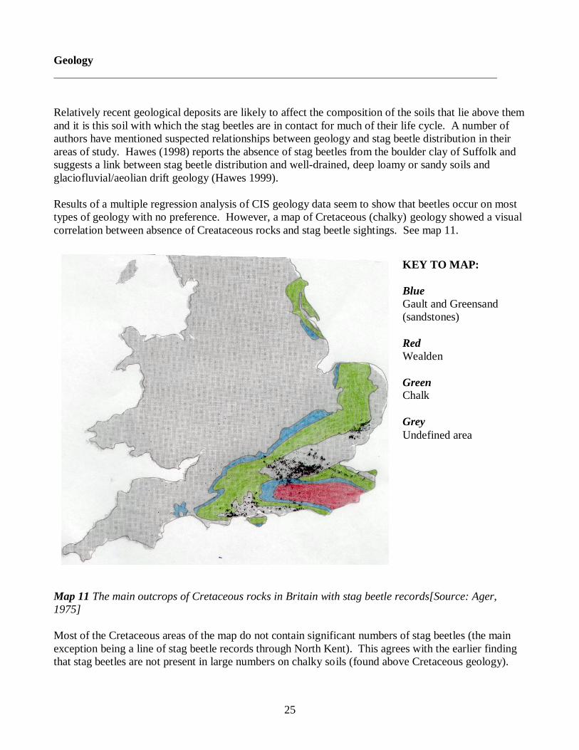
Geology
Relatively recent geological deposits are likely to affect the composition of the soils that lie above them
and it is this soil with which the stag beetles are in contact for much of their life cycle. A number of
authors have mentioned suspected relationships between geology and stag beetle distribution in their
areas of study. Hawes (1998) reports the absence of stag beetles from the boulder clay of Suffolk and
suggests a link between stag beetle distribution and well-drained, deep loamy or sandy soils and
glaciofluvial/aeolian drift geology (Hawes 1999).
Results of a multiple regression analysis of CIS geology data seem to show that beetles occur on most
types of geology with no preference. However, a map of Cretaceous (chalky) geology showed a visual
correlation between absence of Creataceous rocks and stag beetle sightings. See map 11.
Map 11 The main outcrops of Cretaceous rocks in Britain with stag beetle records[Source: Ager,
1975]
Most of the Cretaceous areas of the map do not contain significant numbers of stag beetles (the main
exception being a line of stag beetle records through North Kent). This agrees with the earlier finding
that stag beetles are not present in large numbers on chalky soils (found above Cretaceous geology).
KEY TO MAP:
Blue
Gault and Greensand
(sandstones)
Red
Wealden
Green
Chalk
Grey
Undefined area
26
Rainfall
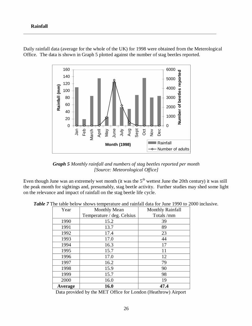
Daily rainfall data (average for the whole of the UK) for 1998 were obtained from the Meterological
Office. The data is shown in Graph 5 plotted against the number of stag beetles reported.
Graph 5 Monthly rainfall and numbers of stag beetles reported per month
[Source: Meteorological Office]
Even though June was an extremely wet month (it was the 5th wettest June the 20th century) it was still
the peak month for sightings and, presumably, stag beetle activity. Further studies may shed some light
on the relevance and impact of rainfall on the stag beetle life cycle.
Table 7 The table below shows temperature and rainfall data for June 1990 to 2000 inclusive.
Year Monthly Mean
Temperature / deg. Celsius
Monthly Rainfall
Totals /mm
1990 15.2 39
1991 13.7 89
1992 17.4 23
1993 17.0 44
1994 16.3 17
1995 15.7 11
1996 17.0 12
1997 16.2 79
1998 15.9 90
1999 15.7 98
2000 16.0 19
Average 16.0 47.4
Data provided by the MET Office for London (Heathrow) Airport
0
20
40
60
80
100
120
140
160
Ja
n
Fe
b
Ma
rch
Ap
ril
Ma
y
Ju
ne
Ju
ly
Au
g
Se
pt
Oct
No
v
De
c
Month (1998)
Ra
infa
ll (
mm
)
0
1000
2000
3000
4000
5000
6000
Nu
mb
er
of
be
etl
es
re
po
rte
d
Rainfall
Number of adults
27
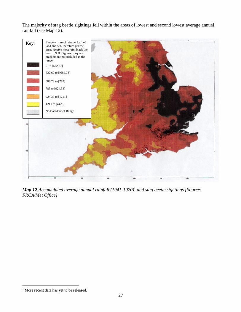
The majority of stag beetle sightings fell within the areas of lowest and second lowest average annual
rainfall (see Map 12).
Map 12 Accumulated average annual rainfall (1941-1970)1 and stag beetle sightings [Source:
FRCA/Met Office]
1 More recent data has yet to be released.
Key:
Range = mm of rain per km2 of
land and sea, therefore yellow
areas receive most rain, black the
least. [N.B. Figures in square
brackets are not included in the
range]
0 to [622.67]
622.67 to [[689.78]
689.78 to [783]
783 to [924.33]
924.33 to [1211]
1211 to [4426]
No Data/Out of Range
28
Competition
Species like the stag beetle that are rare in some particular areas within their geographical ranges may
be so because:
1. They are exploiting a narrow ecological niche, or
2. Interspecific (between species) competition is keeping the population low.
The results of the survey were not used to look for any new information about interspecific
relationships. Little is known about the interspecific relationships between larvae of the beetles of the
family Lucanus in Britain although it is known that larvae of all three species, Lucanus cervus, Dorcus
parallelipipedus (Lesser stag beetle) and Sinodendron cylindricum can inhabit the same piece of rotten
wood (Owen, 1992).
In such a situation the larvae would almost certainly compete for food with each other. This is an area
which needs further study.
29
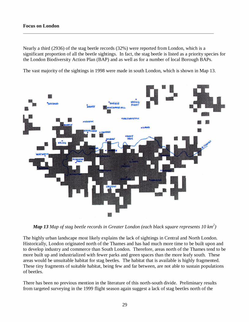
Focus on London
Nearly a third (2936) of the stag beetle records (32%) were reported from London, which is a
significant proportion of all the beetle sightings. In fact, the stag beetle is listed as a priority species for
the London Biodiversity Action Plan (BAP) and as well as for a number of local Borough BAPs.
The vast majority of the sightings in 1998 were made in south London, which is shown in Map 13.
Map 13 Map of stag beetle records in Greater London (each black square represents 10 km2)
The highly urban landscape most likely explains the lack of sightings in Central and North London.
Historically, London originated north of the Thames and has had much more time to be built upon and
to develop industry and commerce than South London. Therefore, areas north of the Thames tend to be
more built up and industrialized with fewer parks and green spaces than the more leafy south. These
areas would be unsuitable habitat for stag beetles. The habitat that is available is highly fragmented.
These tiny fragments of suitable habitat, being few and far between, are not able to sustain populations
of beetles.
There has been no previous mention in the literature of this north-south divide. Preliminary results
from targeted surveying in the 1999 flight season again suggest a lack of stag beetles north of the
30
Thames. Further, targeted work is needed. The greater urban development north of the Thames would
seem to explain the distribution in stag beetles. However, there are other possibilities.
Variations in soil type
Central and North London are mainly London Clay and non-glacial sands and gravels. However,
stag beetles do occur on these surface deposits in south London, as well as on Blackheath beds and
brick earths.
Uneven effort in stag beetle sightings
One cannot expect surveying effort to be uniform during a public survey, but biases do become less
important the greater the number of records received.
Although there were no records received from Richmond Park, it is known to be a common place
for stag beetles (Roger Key and Peter Hammond, pers. comms.). The lack of records could be
explained by the fact that few people visit the park between 6 pm and 10 pm, which is most the
common time to find stag beetles flying.
Variations in geology
Stag beetle sightings were reported from nearly all of the surface and solid geology types in
London1 although the density of the beetles varied.
1 A map of surface geology of London (Plant, 1994) was used in conjunction with our map of stag beetle sightings in
London to assess the importance of geology as a variable affecting stag beetle presence or absence
31
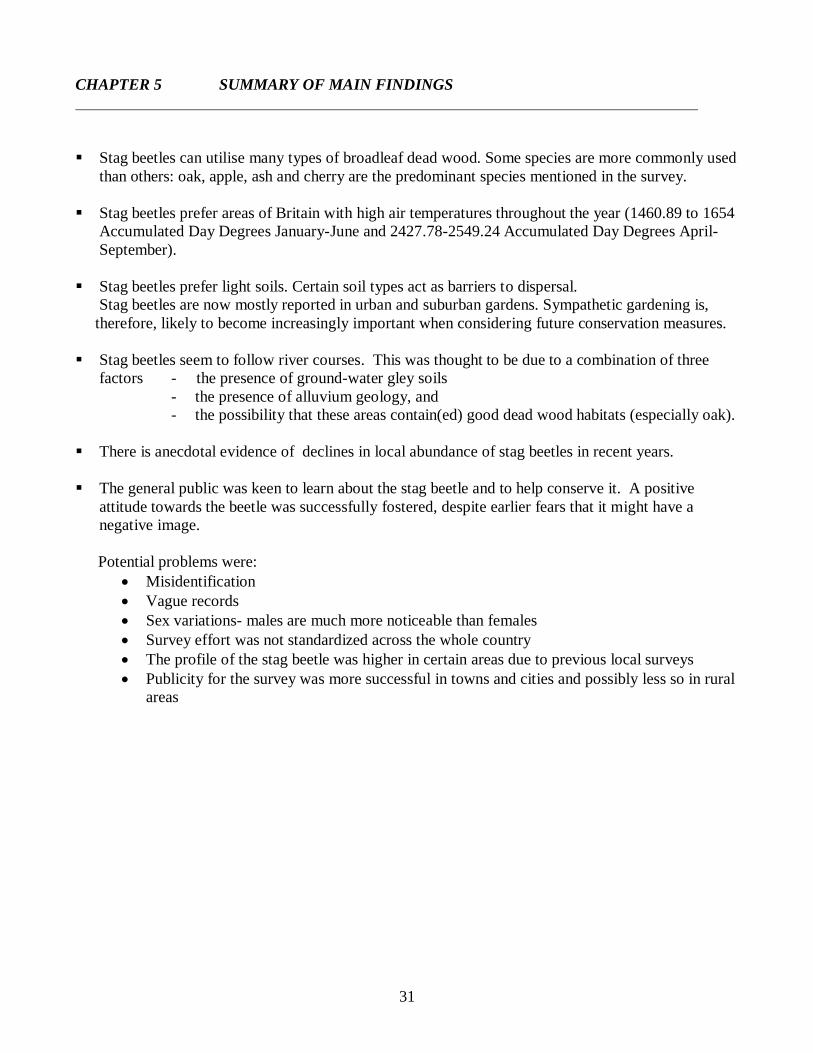
CHAPTER 5 SUMMARY OF MAIN FINDINGS
Stag beetles can utilise many types of broadleaf dead wood. Some species are more commonly used
than others: oak, apple, ash and cherry are the predominant species mentioned in the survey.
Stag beetles prefer areas of Britain with high air temperatures throughout the year (1460.89 to 1654
Accumulated Day Degrees January-June and 2427.78-2549.24 Accumulated Day Degrees April-
September).
Stag beetles prefer light soils. Certain soil types act as barriers to dispersal.
Stag beetles are now mostly reported in urban and suburban gardens. Sympathetic gardening is,
therefore, likely to become increasingly important when considering future conservation measures.
Stag beetles seem to follow river courses. This was thought to be due to a combination of three
factors - the presence of ground-water gley soils
- the presence of alluvium geology, and
- the possibility that these areas contain(ed) good dead wood habitats (especially oak).
There is anecdotal evidence of declines in local abundance of stag beetles in recent years.
The general public was keen to learn about the stag beetle and to help conserve it. A positive
attitude towards the beetle was successfully fostered, despite earlier fears that it might have a
negative image.
Potential problems were:
Misidentification
Vague records
Sex variations- males are much more noticeable than females
Survey effort was not standardized across the whole country
The profile of the stag beetle was higher in certain areas due to previous local surveys
Publicity for the survey was more successful in towns and cities and possibly less so in rural
areas
32
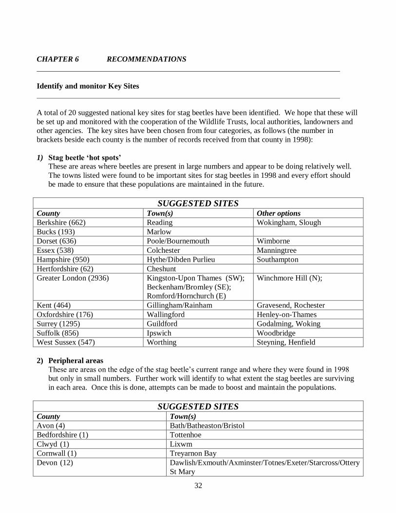
CHAPTER 6 RECOMMENDATIONS
Identify and monitor Key Sites
A total of 20 suggested national key sites for stag beetles have been identified. We hope that these will
be set up and monitored with the cooperation of the Wildlife Trusts, local authorities, landowners and
other agencies. The key sites have been chosen from four categories, as follows (the number in
brackets beside each county is the number of records received from that county in 1998):
1) Stag beetle ‘hot spots’
These are areas where beetles are present in large numbers and appear to be doing relatively well.
The towns listed were found to be important sites for stag beetles in 1998 and every effort should
be made to ensure that these populations are maintained in the future.
SUGGESTED SITES County Town(s) Other options
Berkshire (662) Reading Wokingham, Slough
Bucks (193) Marlow
Dorset (636) Poole/Bournemouth Wimborne
Essex (538) Colchester Manningtree
Hampshire (950) Hythe/Dibden Purlieu Southampton
Hertfordshire (62) Cheshunt
Greater London (2936) Kingston-Upon Thames (SW);
Beckenham/Bromley (SE);
Romford/Hornchurch (E)
Winchmore Hill (N);
Kent (464) Gillingham/Rainham Gravesend, Rochester
Oxfordshire (176) Wallingford Henley-on-Thames
Surrey (1295) Guildford Godalming, Woking
Suffolk (856) Ipswich Woodbridge
West Sussex (547) Worthing Steyning, Henfield
2) Peripheral areas
These are areas on the edge of the stag beetle’s current range and where they were found in 1998
but only in small numbers. Further work will identify to what extent the stag beetles are surviving
in each area. Once this is done, attempts can be made to boost and maintain the populations.
SUGGESTED SITES County Town(s)
Avon (4) Bath/Batheaston/Bristol
Bedfordshire (1) Tottenhoe
Clwyd (1) Lixwm
Cornwall (1) Treyarnon Bay
Devon (12) Dawlish/Exmouth/Axminster/Totnes/Exeter/Starcross/Ottery
St Mary
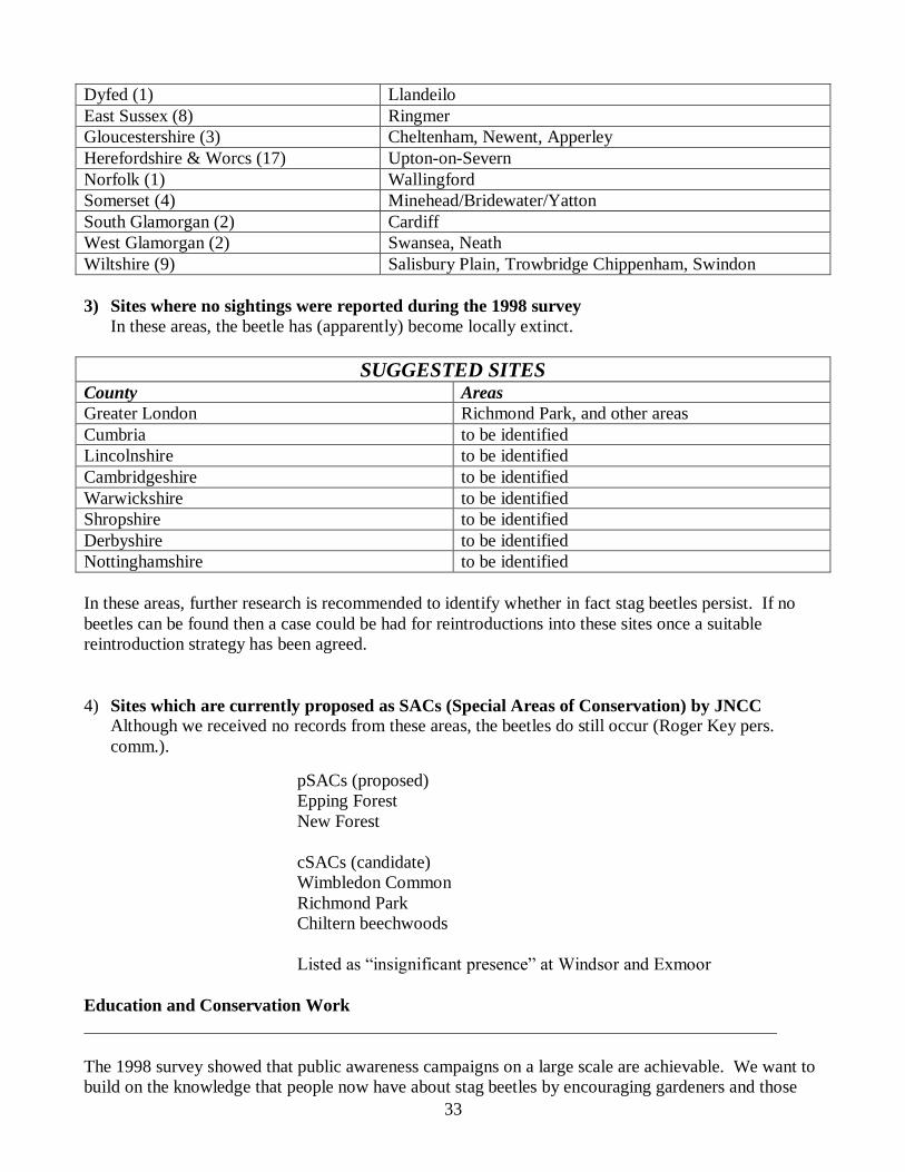
33
Dyfed (1) Llandeilo
East Sussex (8) Ringmer
Gloucestershire (3) Cheltenham, Newent, Apperley
Herefordshire & Worcs (17) Upton-on-Severn
Norfolk (1) Wallingford
Somerset (4) Minehead/Bridewater/Yatton
South Glamorgan (2) Cardiff
West Glamorgan (2) Swansea, Neath
Wiltshire (9) Salisbury Plain, Trowbridge Chippenham, Swindon
3) Sites where no sightings were reported during the 1998 survey
In these areas, the beetle has (apparently) become locally extinct.
SUGGESTED SITES County Areas
Greater London Richmond Park, and other areas
Cumbria to be identified
Lincolnshire to be identified
Cambridgeshire to be identified
Warwickshire to be identified
Shropshire to be identified
Derbyshire to be identified
Nottinghamshire to be identified
In these areas, further research is recommended to identify whether in fact stag beetles persist. If no
beetles can be found then a case could be had for reintroductions into these sites once a suitable
reintroduction strategy has been agreed.
4) Sites which are currently proposed as SACs (Special Areas of Conservation) by JNCC Although we received no records from these areas, the beetles do still occur (Roger Key pers.
comm.).
pSACs (proposed)
Epping Forest
New Forest
cSACs (candidate)
Wimbledon Common
Richmond Park
Chiltern beechwoods
Listed as “insignificant presence” at Windsor and Exmoor
Education and Conservation Work
The 1998 survey showed that public awareness campaigns on a large scale are achievable. We want to
build on the knowledge that people now have about stag beetles by encouraging gardeners and those
34
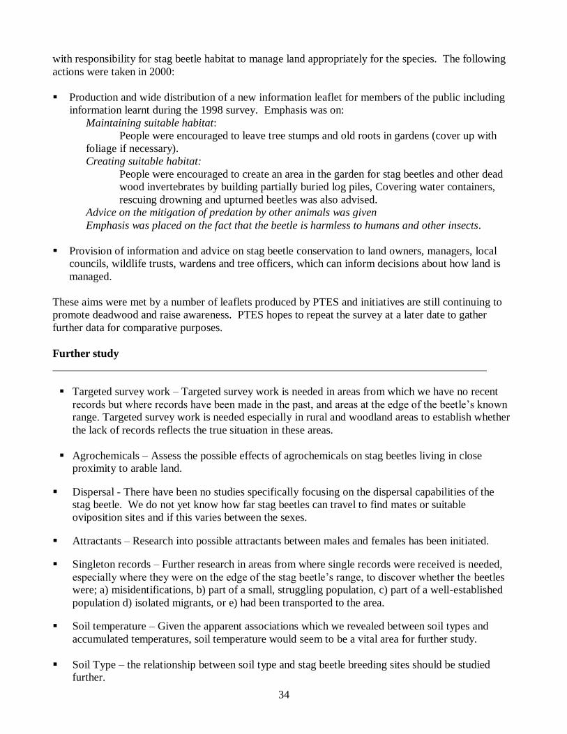
with responsibility for stag beetle habitat to manage land appropriately for the species. The following
actions were taken in 2000:
Production and wide distribution of a new information leaflet for members of the public including
information learnt during the 1998 survey. Emphasis was on:
Maintaining suitable habitat:
People were encouraged to leave tree stumps and old roots in gardens (cover up with
foliage if necessary).
Creating suitable habitat:
People were encouraged to create an area in the garden for stag beetles and other dead
wood invertebrates by building partially buried log piles, Covering water containers,
rescuing drowning and upturned beetles was also advised.
Advice on the mitigation of predation by other animals was given
Emphasis was placed on the fact that the beetle is harmless to humans and other insects.
Provision of information and advice on stag beetle conservation to land owners, managers, local
councils, wildlife trusts, wardens and tree officers, which can inform decisions about how land is
managed.
These aims were met by a number of leaflets produced by PTES and initiatives are still continuing to
promote deadwood and raise awareness. PTES hopes to repeat the survey at a later date to gather
further data for comparative purposes.
Further study
Targeted survey work – Targeted survey work is needed in areas from which we have no recent
records but where records have been made in the past, and areas at the edge of the beetle’s known
range. Targeted survey work is needed especially in rural and woodland areas to establish whether
the lack of records reflects the true situation in these areas.
Agrochemicals – Assess the possible effects of agrochemicals on stag beetles living in close
proximity to arable land.
Dispersal - There have been no studies specifically focusing on the dispersal capabilities of the
stag beetle. We do not yet know how far stag beetles can travel to find mates or suitable
oviposition sites and if this varies between the sexes.
Attractants – Research into possible attractants between males and females has been initiated.
Singleton records – Further research in areas from where single records were received is needed,
especially where they were on the edge of the stag beetle’s range, to discover whether the beetles
were; a) misidentifications, b) part of a small, struggling population, c) part of a well-established
population d) isolated migrants, or e) had been transported to the area.
Soil temperature – Given the apparent associations which we revealed between soil types and
accumulated temperatures, soil temperature would seem to be a vital area for further study.
Soil Type – the relationship between soil type and stag beetle breeding sites should be studied
further.
35
Abundance – is currently being investigated using road kill and garden surveys (2001).
Habitat availability – trials are underway to determine whether stag beetles conservation can be
enhanced by the provision of man-made ovipositing boxes.
Reintroductions, translocations and captive breeding
Translocation is a method for re-establishing the beetle in areas where it no longer occurs.
Although it is possible to successfully breed stag beetles in captivity, captive breeding is labour
intensive and brings with it the possible risk of introducing disease and parasites from a controlled,
captive environment into the wild. (Prof. J. Owen pers. comm..)
The role of captive breeding should therefore remain for the present a research tool, and an education
tool in zoos and conservation centres.
36
REFERENCES
Ager, D.V. (1975) Introducing geology. Faber and Faber, London.
Clark, J.T. (1966) The distribution of Lucanus cervus (L.) (Col., Lucinadae) in Britain. Entomologist’s
Monthly Magazine. 102: 199-204
Hawes, C.J. (1998) The Stag Beetle Lucanus cervus L. (Coleoptera: Lucanidae) in Suffolk – a first
report. Trans. Suffolk Nat. Soc., 34: 35-49
Hawes, C.J. (1999) The Stag Beetle Lucanus cervus L. (Coleoptera: Lucanidae)– The 1998 National
Survey – an interim report. Trans. Suffolk Nat. Soc., 35: 71-75
Hawes, C.J. (2000) the Stag Beetle Lucanus cervus L. (Coleoptera: Lucanidae) –a hypothesis for its
distribution in Suffolk. . Trans. Suffolk Nat. Soc., 36: 65-70
Klausnitzer, B. (1995) ‘Die Hirschkäfer’. Westarp Wissenschaften
Plant. C.W. (1994) ‘The Surface Geology of the London Area’. Publ: London Natural History Society
Tullett, A.G. (1998) ‘Conservation status and habitat requirements of the stag-beetle Lucanus cervus
(L.), in Britain’ (A dissertation for fulfillment MSc at UEA)
Van Helsdingen, P.J., Willemse, L. & Speight, M.C.D. (eds) (1995) ‘Background information on
invertebrates of the Habitats Directive and the Bern Convention: Part 1 – Crustacea, Coleoptera and
Lepidoptera, pp. 53-58. Council of Europe Publishing. Cited in Tullett 1998 (reference above)
Whitehead, P.F. (1993). Lucanus cervus (L.) (Col., Lucanidae) in Worcestershire with a hypothesis for
its distribution. Entomologist’s Mon. Mag. 129:206
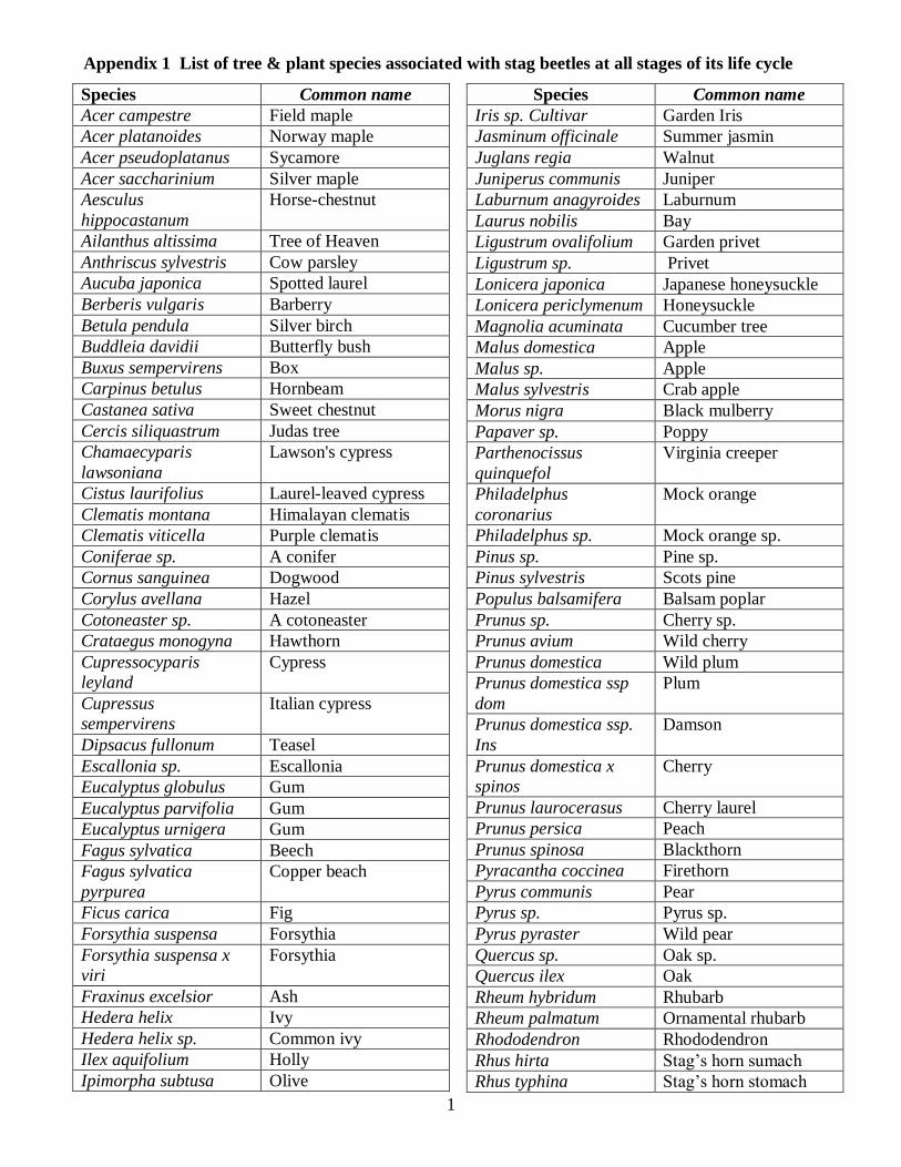
Appendix 1 List of tree & plant species associated with stag beetles at all stages of its life cycle
1
Species Common name
Acer campestre Field maple
Acer platanoides Norway maple
Acer pseudoplatanus Sycamore
Acer saccharinium Silver maple
Aesculus
hippocastanum
Horse-chestnut
Ailanthus altissima Tree of Heaven
Anthriscus sylvestris Cow parsley
Aucuba japonica Spotted laurel
Berberis vulgaris Barberry
Betula pendula Silver birch
Buddleia davidii Butterfly bush
Buxus sempervirens Box
Carpinus betulus Hornbeam
Castanea sativa Sweet chestnut
Cercis siliquastrum Judas tree
Chamaecyparis
lawsoniana
Lawson's cypress
Cistus laurifolius Laurel-leaved cypress
Clematis montana Himalayan clematis
Clematis viticella Purple clematis
Coniferae sp. A conifer
Cornus sanguinea Dogwood
Corylus avellana Hazel
Cotoneaster sp. A cotoneaster
Crataegus monogyna Hawthorn
Cupressocyparis
leyland
Cypress
Cupressus
sempervirens
Italian cypress
Dipsacus fullonum Teasel
Escallonia sp. Escallonia
Eucalyptus globulus Gum
Eucalyptus parvifolia Gum
Eucalyptus urnigera Gum
Fagus sylvatica Beech
Fagus sylvatica
pyrpurea
Copper beach
Ficus carica Fig
Forsythia suspensa Forsythia
Forsythia suspensa x
viri
Forsythia
Fraxinus excelsior Ash
Hedera helix Ivy
Hedera helix sp. Common ivy
Ilex aquifolium Holly
Ipimorpha subtusa Olive
Species Common name
Iris sp. Cultivar Garden Iris
Jasminum officinale Summer jasmin
Juglans regia Walnut
Juniperus communis Juniper
Laburnum anagyroides Laburnum
Laurus nobilis Bay
Ligustrum ovalifolium Garden privet
Ligustrum sp. Privet
Lonicera japonica Japanese honeysuckle
Lonicera periclymenum Honeysuckle
Magnolia acuminata Cucumber tree
Malus domestica Apple
Malus sp. Apple
Malus sylvestris Crab apple
Morus nigra Black mulberry
Papaver sp. Poppy
Parthenocissus
quinquefol
Virginia creeper
Philadelphus
coronarius
Mock orange
Philadelphus sp. Mock orange sp.
Pinus sp. Pine sp.
Pinus sylvestris Scots pine
Populus balsamifera Balsam poplar
Prunus sp. Cherry sp.
Prunus avium Wild cherry
Prunus domestica Wild plum
Prunus domestica ssp
dom
Plum
Prunus domestica ssp.
Ins
Damson
Prunus domestica x
spinos
Cherry
Prunus laurocerasus Cherry laurel
Prunus persica Peach
Prunus spinosa Blackthorn
Pyracantha coccinea Firethorn
Pyrus communis Pear
Pyrus sp. Pyrus sp.
Pyrus pyraster Wild pear
Quercus sp. Oak sp.
Quercus ilex Oak
Rheum hybridum Rhubarb
Rheum palmatum Ornamental rhubarb
Rhododendron Rhododendron
Rhus hirta Stag’s horn sumach
Rhus typhina Stag’s horn stomach
Appendix 1 List of tree & plant species associated with stag beetles at all stages of its life cycle
2
Species Common name
Ricinus communis Castor oil plant
Robinia pseudoacacia False acacia
Rosa sp. A rose
Rosa sp. Cultivar Cultivated rose
Rubus fruticosus A bramble
Salix cinerea x repens A willow
Salix fragilis A willow
Salix sp. A sallow
Salvia x superba Sage
Sambucus nigra Elder
Species Common name
Sorbus aucuparia Rowan
Syringa vulgaris Lilac
Tamarix gallica Tamarisk
Taxus baccata Yew
Tilia sp. A lime
Ulmus procera English elm
Ulmus sp. An elm
Viburnum opulus Guelder rose
Viburnum tinus Laurustinus
Viburnum x
rhytidophylloi
A viburnum
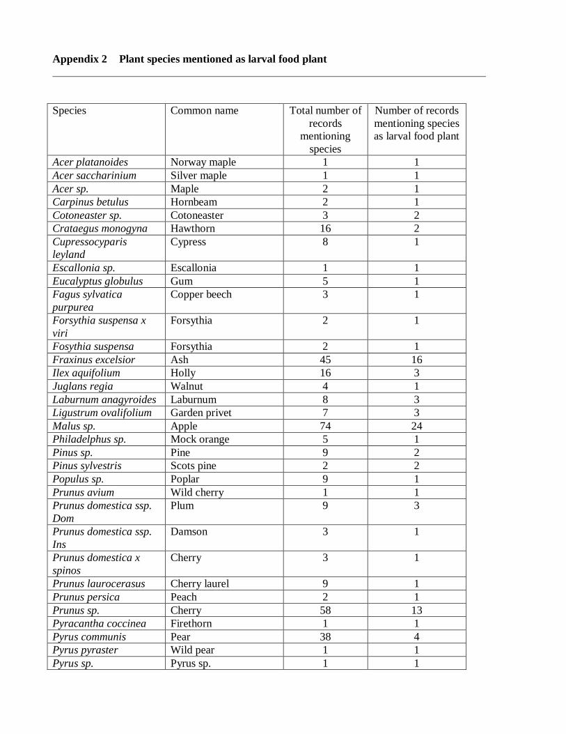
Appendix 2 Plant species mentioned as larval food plant
Species Common name Total number of
records
mentioning
species
Number of records
mentioning species
as larval food plant
Acer platanoides Norway maple 1 1
Acer saccharinium Silver maple 1 1
Acer sp. Maple 2 1
Carpinus betulus Hornbeam 2 1
Cotoneaster sp. Cotoneaster 3 2
Crataegus monogyna Hawthorn 16 2
Cupressocyparis
leyland
Cypress 8 1
Escallonia sp. Escallonia 1 1
Eucalyptus globulus Gum 5 1
Fagus sylvatica
purpurea
Copper beech 3 1
Forsythia suspensa x
viri
Forsythia 2 1
Fosythia suspensa Forsythia 2 1
Fraxinus excelsior Ash 45 16
Ilex aquifolium Holly 16 3
Juglans regia Walnut 4 1
Laburnum anagyroides Laburnum 8 3
Ligustrum ovalifolium Garden privet 7 3
Malus sp. Apple 74 24
Philadelphus sp. Mock orange 5 1
Pinus sp. Pine 9 2
Pinus sylvestris Scots pine 2 2
Populus sp. Poplar 9 1
Prunus avium Wild cherry 1 1
Prunus domestica ssp.
Dom
Plum 9 3
Prunus domestica ssp.
Ins
Damson 3 1
Prunus domestica x
spinos
Cherry 3 1
Prunus laurocerasus Cherry laurel 9 1
Prunus persica Peach 2 1
Prunus sp. Cherry 58 13
Pyracantha coccinea Firethorn 1 1
Pyrus communis Pear 38 4
Pyrus pyraster Wild pear 1 1
Pyrus sp. Pyrus sp. 1 1
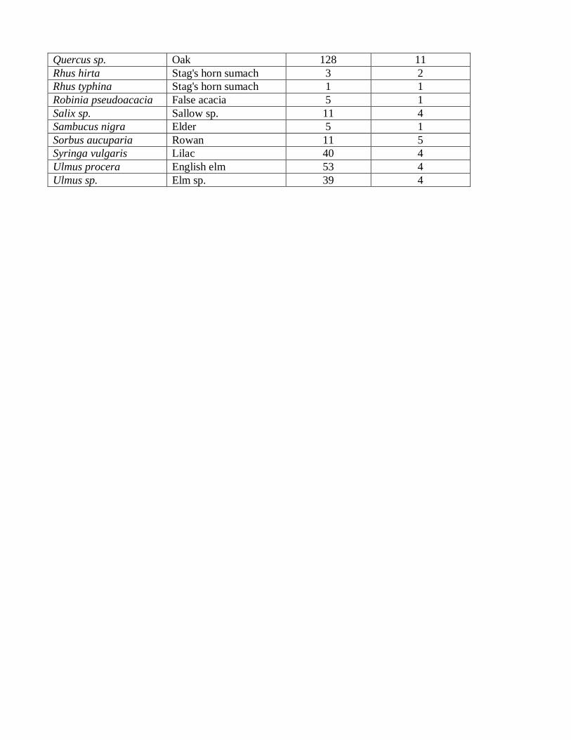
Quercus sp. Oak 128 11
Rhus hirta Stag's horn sumach 3 2
Rhus typhina Stag's horn sumach 1 1
Robinia pseudoacacia False acacia 5 1
Salix sp. Sallow sp. 11 4
Sambucus nigra Elder 5 1
Sorbus aucuparia Rowan 11 5
Syringa vulgaris Lilac 40 4
Ulmus procera English elm 53 4
Ulmus sp. Elm sp. 39 4
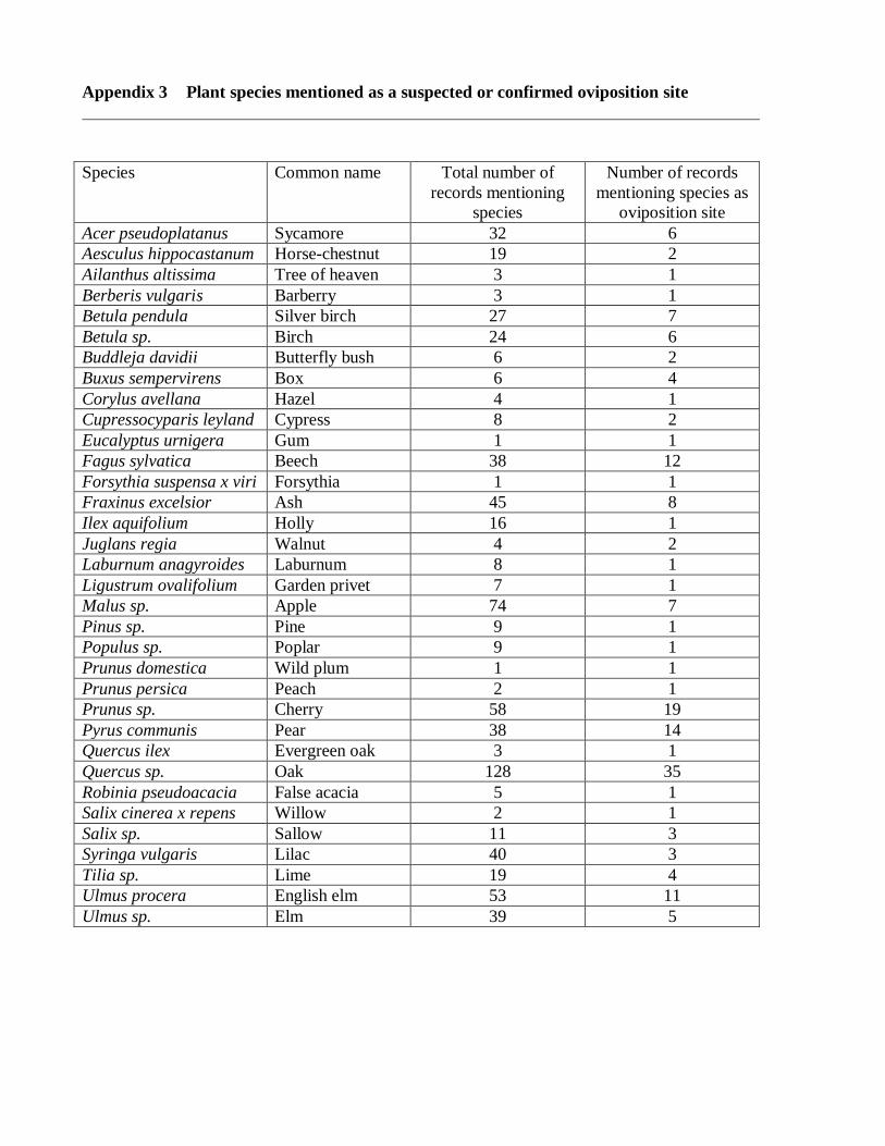
Appendix 3 Plant species mentioned as a suspected or confirmed oviposition site
Species Common name Total number of
records mentioning
species
Number of records
mentioning species as
oviposition site
Acer pseudoplatanus Sycamore 32 6
Aesculus hippocastanum Horse-chestnut 19 2
Ailanthus altissima Tree of heaven 3 1
Berberis vulgaris Barberry 3 1
Betula pendula Silver birch 27 7
Betula sp. Birch 24 6
Buddleja davidii Butterfly bush 6 2
Buxus sempervirens Box 6 4
Corylus avellana Hazel 4 1
Cupressocyparis leyland Cypress 8 2
Eucalyptus urnigera Gum 1 1
Fagus sylvatica Beech 38 12
Forsythia suspensa x viri Forsythia 1 1
Fraxinus excelsior Ash 45 8
Ilex aquifolium Holly 16 1
Juglans regia Walnut 4 2
Laburnum anagyroides Laburnum 8 1
Ligustrum ovalifolium Garden privet 7 1
Malus sp. Apple 74 7
Pinus sp. Pine 9 1
Populus sp. Poplar 9 1
Prunus domestica Wild plum 1 1
Prunus persica Peach 2 1
Prunus sp. Cherry 58 19
Pyrus communis Pear 38 14
Quercus ilex Evergreen oak 3 1
Quercus sp. Oak 128 35
Robinia pseudoacacia False acacia 5 1
Salix cinerea x repens Willow 2 1
Salix sp. Sallow 11 3
Syringa vulgaris Lilac 40 3
Tilia sp. Lime 19 4
Ulmus procera English elm 53 11
Ulmus sp. Elm 39 5
Appendix 4 Plant species mentioned as a perch for adults
Species Common name Total number of
records mentioning
species
Number of records
mentioning species as
adult perch
Acer campestre Field maple 1 1
Acer platanoides Norway maple 1 1
Aesculus hippocastanum Horse-chestnut 19 7
Anthriscus sylvestris Cow parsley 2 1
Aucuba japonica Spotted laurel 2 1
Betula pendula Silver birch 27 4
Castanea sativa Sweet chestnut 6 1
Cercis siliquastrum Judas tree 1 1
Chamaecyparis
lawsoniana
Lawson's cypress 3 2
Cistus laurifolius Laurel-leaved
Cypress
1 1
Clematis montana Himalayan
clematis
2 1
Clematis viticella Purple clematis 1 1
Coniferae sp. Conifer 21 9
Cornus sanguinea Dogwood 1 1
Corylus avellana Hazel 4 1
Crataegus monogyna Hawthorn 16 7
Cupressocyparis leyland Cypress 8 1
Cupressus sempervirens Italian cypress 1 1
Dipsacus fullonum Teasel 1 1
Eucalyptus parvifolia Gum 1 1
Fagus sylvatica Beech 38 6
Ficus carica Fig 2 2
Fraxinus excelsior Ash 45 3
Hedera helix Ivy 8 6
Hedera helix sp. Common ivy 2 2
Ilex aquifolium Holly 16 6
Ipimorpha subtusa Olive 1 1
Iris sp. Cultivar Garden Iris 1 1
Jasminum officinale Summer jasmin 2 1
Juniperus communis Juniper 1 1
Laurus nobilis Bay 2 2
Ligustrum ovalifolium Garden privet 7 1
Ligustrum sp. Privet 6 1
Lonicera japonica Japanese
honeysuckle
1 1
Lonicera periclymenum Honeysuckle 5 3
Magnolia acuminata Cucumber tree 5 2
Malus domestica Apple 1 1
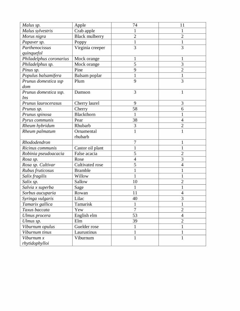
Malus sp. Apple 74 11
Malus sylvestris Crab apple 1 1
Morus nigra Black mulberry 2 2
Papaver sp. Poppy 1 1
Parthenocissus
quinquefol
Virginia creeper 3 3
Philadelphus coronarius Mock orange 1 1
Philadelphus sp. Mock orange 5 3
Pinus sp. Pine 9 2
Populus balsamifera Balsam poplar 1 1
Prunus domestica ssp
dom
Plum 9 3
Prunus domestica ssp.
Ins
Damson 3 1
Prunus laurocerasus Cherry laurel 9 3
Prunus sp. Cherry 58 6
Prunus spinosa Blackthorn 1 1
Pyrus communis Pear 38 4
Rheum hybridum Rhubarb 3 2
Rheum palmatum Ornamental
rhubarb
1 1
Rhododendron 7 1
Ricinus communis Castor oil plant 1 1
Robinia pseudoacacia False acacia 5 2
Rosa sp. Rose 4 3
Rosa sp. Cultivar Cultivated rose 5 4
Rubus fruticosus Bramble 1 1
Salix fragilis Willow 1 1
Salix sp. Sallow 10 2
Salvia x superba Sage 1 1
Sorbus aucuparia Rowan 11 4
Syringa vulgaris Lilac 40 3
Tamarix gallica Tamarisk 1 1
Taxus baccata Yew 7 2
Ulmus procera English elm 53 4
Ulmus sp. Elm 39 2
Viburnum opulus Guelder rose 1 1
Viburnum tinus Laurustinus 1 1
Viburnum x
rhytidophylloi
Viburnum 1 1
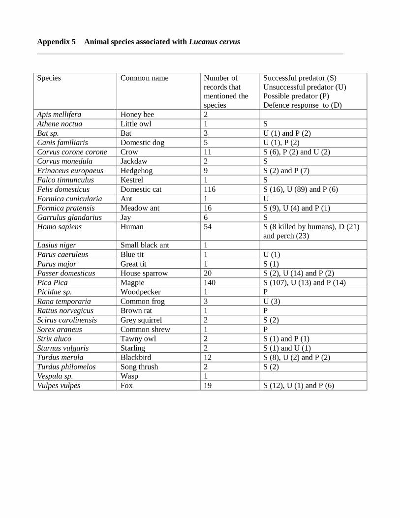
Appendix 5 Animal species associated with Lucanus cervus
Species Common name Number of
records that
mentioned the
species
Successful predator (S)
Unsuccessful predator (U)
Possible predator (P)
Defence response to (D)
Apis mellifera Honey bee 2
Athene noctua Little owl 1 S
Bat sp. Bat 3 U (1) and P (2)
Canis familiaris Domestic dog 5 U (1), P (2)
Corvus corone corone Crow 11 S (6), P (2) and U (2)
Corvus monedula Jackdaw 2 S
Erinaceus europaeus Hedgehog 9 S (2) and P (7)
Falco tinnunculus Kestrel 1 S
Felis domesticus Domestic cat 116 S (16), U (89) and P (6)
Formica cunicularia Ant 1 U
Formica pratensis Meadow ant 16 S (9), U (4) and P (1)
Garrulus glandarius Jay 6 S
Homo sapiens Human 54 S (8 killed by humans), D (21)
and perch (23)
Lasius niger Small black ant 1
Parus caeruleus Blue tit 1 U (1)
Parus major Great tit 1 S (1)
Passer domesticus House sparrow 20 S (2), U (14) and P (2)
Pica Pica Magpie 140 S (107), U (13) and P (14)
Picidae sp. Woodpecker 1 P
Rana temporaria Common frog 3 U (3)
Rattus norvegicus Brown rat 1 P
Scirus carolinensis Grey squirrel 2 S (2)
Sorex araneus Common shrew 1 P
Strix aluco Tawny owl 2 S (1) and P (1)
Sturnus vulgaris Starling 2 S (1) and U (1)
Turdus merula Blackbird 12 S (8), U (2) and P (2)
Turdus philomelos Song thrush 2 S (2)
Vespula sp. Wasp 1
Vulpes vulpes Fox 19 S (12), U (1) and P (6)
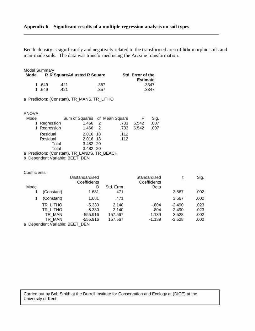
Appendix 6 Significant results of a multiple regression analysis on soil types
Beetle density is significantly and negatively related to the transformed area of lithomorphic soils and
man-made soils. The data was transformed using the Arcsine transformation. Model Summary Model R R Square Adjusted R Square Std. Error of the
Estimate 1 .649 .421 .357 .3347 1 .649 .421 .357 .3347
a Predictors: (Constant), TR_MANS, TR_LITHO
ANOVA Model Sum of Squares df Mean Square F Sig.
1 Regression 1.466 2 .733 6.542 .007 1 Regression 1.466 2 .733 6.542 .007
Residual 2.016 18 .112 Residual 2.016 18 .112 Total 3.482 20 Total 3.482 20
a Predictors: (Constant), TR_LANDS, TR_BEACH b Dependent Variable: BEET_DEN
Coefficients Unstandardised
Coefficients Standardised
Coefficients t Sig.
Model B Std. Error Beta 1 (Constant) 1.681 .471 3.567 .002
1 (Constant) 1.681 .471 3.567 .002
TR_LITHO -5.330 2.140 -.804 -2.490 .023 TR_LITHO -5.330 2.140 -.804 -2.490 .023 TR_MAN -555.916 157.567 -1.139 3.528 .002 TR_MAN -555.916 157.567 -1.139 -3.528 .002
a Dependent Variable: BEET_DEN
Carried out by Bob Smith at the Durrell Institute for Conservation and Ecology at (DICE) at the University of Kent