Embed Size (px)
Citation preview

The Maryland-National Capital Park and Planning Commission
Prince George’s County Planning Department
Development Review Division
301-952-3530
Note: Staff reports can be accessed at www.mncppc.org/pgco/planning/plan.htm.
Detailed Site Plan DSP-08043-01
Alternative Compliance AC-16003
Application General Data
Project Name:
Royal Farms, Sansbury (Lots 1–3)
Location:
South side of Ritchie Marlboro Road in the
southeast quadrant of the intersection with Sansbury
Road.
Applicant/Address:
Two Farms, Inc.
d/b/a Royal Farms
3611 Roland Avenue
Baltimore, MD 21211
Planning Board Hearing Date: 05/19/16
Staff Report Date: 05/05/16
Date Accepted: 03/17/16
Planning Board Action Limit: 05/22/16
Plan Acreage: 4.48
Zone: M-X-T
Dwelling Units: N/A
Gross Floor Area: 5,166 sq. ft.
Planning Area: 78
Council District: 06
Election District 15
Municipality: N/A
200-Scale Base Map: 203SE09
Purpose of Application Notice Dates
A 5,166-square-foot food and beverage store and
gas station and a request for Alternative
Compliance from Section 4.6(c)(2), Development
from Special Roadways, of the 2010 Prince
George’s County Landscape Manual.
Informational Mailing: 10/21/15
Acceptance Mailing: 03/25/16
Sign Posting Deadline: 04/05/16
Staff Recommendation
Staff Reviewer: Cynthia Fenton
Phone Number: 301-952-3412
E-mail: [email protected]
APPROVAL APPROVAL WITH
CONDITIONS DISAPPROVAL DISCUSSION
X
2 DSP-08043-01 & AC-16003

3 DSP-08043-01 & AC-16003
THE MARYLAND-NATIONAL CAPITAL
PARK AND PLANNING COMMISSION
PRINCE GEORGE’S COUNTY PLANNING BOARD
STAFF REPORT
SUBJECT: Detailed Site Plan DSP-08043-01
Type II Tree Conservation Plan TCPII-021-09-01
Royal Farms, Sansbury (Lots 1–3)
The Urban Design staff has reviewed the detailed site plan for the subject property and presents
the following evaluation and findings leading to a recommendation of APPROVAL, as described in the
Recommendation section of this report.
EVALUATION
This detailed site plan was reviewed and evaluated for compliance with the following criteria:
a. The requirements of the Prince George’s County Zoning Ordinance in the M-X-T (Mixed
Use-Transportation Oriented) Zone and site design guidelines;
b. The requirements of Conceptual Site Plan CSP-07002;
c. The requirements of Preliminary Plan of Subdivision 4-07057;
d. The requirements of Detailed Site Plan DSP-08043 (Infrastructure);
e. The requirements of the 2010 Prince George’s County Landscape Manual;
f. The requirements of the Prince George’s County Woodland Conservation and Tree Preservation
Ordinance; and
g. Referral comments.
FINDINGS
Based upon the analysis of the subject detailed site plan, the Urban Design staff recommends the
following findings:
1. Request: The subject application is a detailed site plan (DSP) for a 5,166-square-foot food and
beverage store and gas station on 4.48 acres of land.
4 DSP-08043-01 & AC-16003
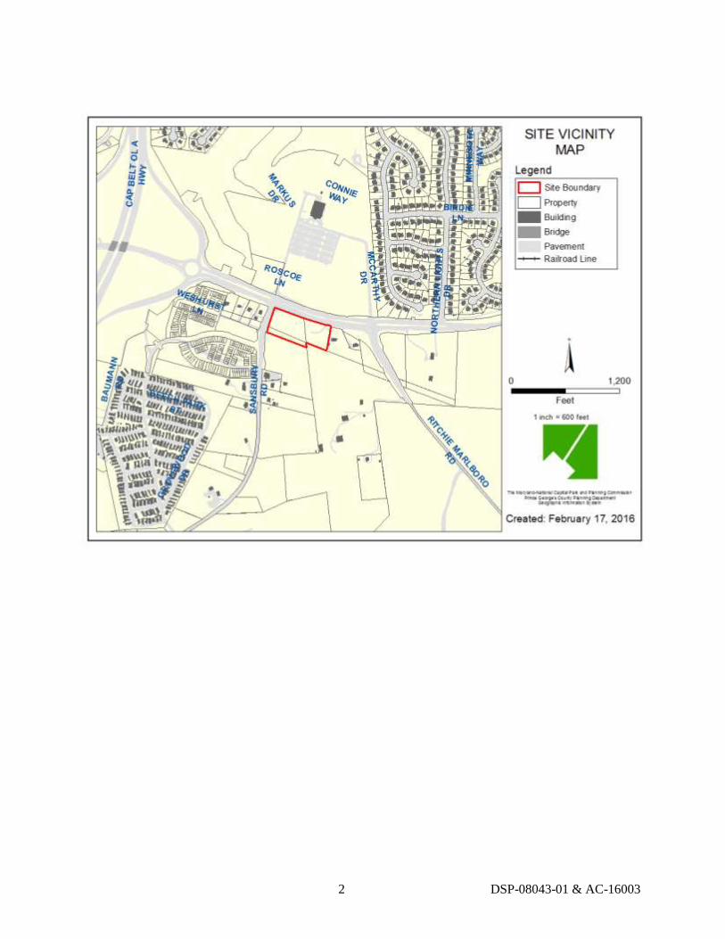
2. Development Data Summary:
EXISTING PROPOSED
Zone(s) M-X-T M-X-T
Use(s) Vacant Food and Beverage Store
and Gas Station
Parcels* 3 0
Lots 0 3
Acreage 4.48 4.48
Gross Floor Area (GFA) 0 5,166 sq. ft.
Note: * The existing parcel references should be noted on the DSP.
Overall Floor Area Ratio (FAR) in the M-X-T Zone
Base Density Allowed 0.40 FAR
Total FAR Permitted* 0.40 FAR
Total FAR Proposed 0.03 FAR
Note: * Without optional method of development.
Parking Requirements*
Total Parking Spaces Required** 40 Spaces
Gas Station @1 space per employee 2 spaces
3,000 GFA @ 1 space per 150 GFA 20 spaces
3,000+ GFA @ 1 space per 200 GFA 11 spaces
Outdoor seating @ 1 space per 3 seats 7 spaces
Total Parking Spaces Provided 53 Spaces
Regular Spaces (9.5 ft. x 19 ft.) 51
Handicap Spaces (19 ft. x 16 ft.) 2 (van accessible)
Loading Spaces Required 1 Space
Loading Spaces Provided 1 Space
Notes: * The number of parking and loading spaces for developments in the M-X-T Zone are to
be calculated by the applicant and submitted for Planning Board approval at the time of
DSP, as stated in Sections 27-574 and 27-583 of the Zoning Ordinance. In this case, the
applicant has chosen to provide the number of parking and loading spaces normally
required under Sections 27-568 and 27-582.
** General Note 35 shall be revised to show the correct number of parking spaces required.
3. Location: The subject property is located in the southeast corner of the intersection of Ritchie
Marlboro Road and Sansbury Road, in Planning Area 78, Councilmanic District 6. This
intersection is designated by the 2007 Approved Westphalia Sector Plan and Sectional Map
Amendment (Westphalia Sector Plan and SMA) as one of nine gateways into Westphalia and is
proposed as the location of a mixed-use village center.

5 DSP-08043-01 & AC-16003
4. Surrounding Uses: Across Ritchie Marlboro Road to the north is land owned by the Greater
Morning Star Pentecostal Church in the Townhouse (R-T) Zone. To the south is property owned
by the Ritchie Baptist Church, which is zoned Mixed Use–Transportation Oriented (M-X-T) and
is envisioned as a possible future component of the gateway village center. To the east of the
subject property is a single-family home facing Ritchie Marlboro Road in the Rural Residential
(R-R) Zone. To the west, across Sansbury Road, is a proposed townhouse and commercial
component of the Westphalia Row development in the M-X-T Zone.
5. Previous Approvals: The subject property was rezoned from the Residential-Agricultural (R-A)
Zone to the M-X-T Zone in the 2007 Westphalia Sector Plan and SMA. As part of the rezoning,
the Prince George’s County District Council approved the concept plan for development of the
subject property and the neighboring properties to the west and south as an integrated mixed-use
development. This concept plan is illustrated in plan view, with illustrative perspective renderings
in Exhibit 19 of the public record for the Westphalia SMA, and is intended to serve as a vision to
guide the development of the village center.
Conceptual Site Plan CSP-07002 was approved by the District Council on November 10, 2008
(PGCPB Resolution No. 08-50) with 15 conditions.
The site is the subject of approved Preliminary Plan of Subdivision (PPS) 4-07057; the resolution
of approval (PGCPB No. 08-51) was adopted by the Prince George’s County Planning Board on
April 24, 2008 with 14 conditions. The PPS is valid through December 31, 2017.
The site has a DSP for infrastructure for grading and utilities (DSP-08043) which was approved
by the Planning Board on June 11, 2009 and adopted on July 9, 2009 via PGCPB Resolution
No. 09-98, with one condition.
A Stormwater Management Concept Approval Letter (38411-2006-00) and associated plan were
submitted with the application. The approval was issued on December 24, 2014 from the Prince
George’s County Department of Permitting, Inspections and Enforcement (DPIE) and is valid
through May 4, 2017.
6. Design Features: The 4.48-acre site has a somewhat irregular rectangular shape which is
comprised of three parcels. The proposed development, including access, will comprise proposed
Lot 1 and a portion of proposed Lot 2. The remainder of the site is anticipated for future
development. The site plan proposes a single right-in/right-out point of vehicular access along the
site’s frontage on Sansbury Road and two full access points along Ritchie Marlboro Road. The
site plan further shows a location for potential access to the adjacent church property along the
south side of the site. This potential future access should be clearly labeled on all the plans,
including the tree conservation plan (TCP). The proposed site design places the gas station
canopy with eight pump islands (16 fueling stations) along Ritchie Marlboro Road and the food
and beverage store for the Royal Farms behind, adjacent to the access driveway from Sansbury
Road. Surface parking is proposed throughout the site. A free air station is shown in the required
landscape strip; it should be relocated to a location within the parking area. In addition, all
references to a car wash and other facilities or elements not proposed in this DSP should be
deleted from the site keynotes. Stormwater management is provided via an underground facility.
The 5,166-square-foot retail building for the Royal Farms is designed to reflect a somewhat rural
aesthetic, which is a trademark of Royal Farms. The new prototype model has been constructed
throughout Maryland and, most recently, on Allentown Road in Camp Springs. A similar Royal
Farms was also recently approved in Brandywine. The building design incorporates a band of
6 DSP-08043-01 & AC-16003
composite siding at the top portion of the building, brick veneer in the middle, and stone veneer at
the base of the building. The main entrance projects from the rest of the building and features
two side entry points. The front elevation is accented with a shed-style roof over the main
entrance supported by stone veneer and painted steel columns and topped with a cupola, and
over-sized windows that help break up the horizontal mass. The rear elevation, which abuts the
church property to the south, presents long uninterrupted bands of the composite siding, red brick,
and stone veneer with awnings over the employee door and windows. Outdoor seating is
proposed.
Due to the high visibility of the pumps, canopy, and retail building on a corner site such as the
subject site, and particularly at a Westphalia gateway location, the design of all the site plan
elements is extremely important and all materials should be of high quality. The proposed
exterior building materials, including stone, brick, and composite siding, are of notable quality
and durability. The pumps and canopy are reflective of the architecture and materials of the main
building. Staff recommends that, for enhanced visual interest, the flat canopy roof of the pump
station be replaced with a gabled roof similar to that provided in Anne Arundel County. The
applicant has agreed to provide the revised roof.
Although not required, Royal Farms, as it did with its Camp Springs location, will obtain
Leadership in Energy and Environmental Design (LEED) certification if the project scores high
enough for certification.
Signage: The applicant is proposing a unified sign package including one 25-foot-high
freestanding pylon sign, two neon-illuminated building-mounted signs (on the front and rear
elevations), signage on the fueling station canopy, and a gateway monument sign. The business
logo is distinctive without being excessive, incorporating only a blue “Royal” and green “Farms”
on all sign types and using channel letters on the main building. The gateway sign, as currently
proposed, is constructed of a combination of brick veneer and stone to match the building
materials of main building, with black wrought-iron picket fencing on the top. Staff is
recommending that the applicant revise the design and materials of the gateway monument sign
to reflect the materials and design approved by Westphalia stakeholders, and as approved by the
Planning Board for other areas of Westphalia, which includes a more urban pre-cast concrete and
stone veneer. In response to staff comments, the applicant has also agreed to provide a stone base
for the freestanding pylon sign that will complement both the building architecture and the
revised gateway monument sign.
The applicant is proposing underground stormwater management facilities. As noted above, a
stormwater concept plan was approved by DPIE that includes the facilities.
COMPLIANCE WITH EVALUATION CRITERIA:
7. Prince George’s County Zoning Ordinance: The subject application has been reviewed for
compliance with the requirements in the M-X-T Zone and the site plan design guidelines of the
Zoning Ordinance and was found to be in compliance with those regulations.
a. Required Findings for Detailed Site Plans and Conceptual Site Plans in the
M-X-T Zone:

7 DSP-08043-01 & AC-16003
Section 27-546(d)
(1) The proposed development is in conformance with the purposes and other
provisions of this Division;
Comment: The purposes of the M-X-T Zone are provided for in Section 27-542 of the
Zoning Ordinance. The subject DSP will be in conformance with the purposes and other
provisions of the M-X-T Zone. Specifically, in accordance with Section 27-542(a)(2),
this development will facilitate the development envisioned in CSP-07002 and 4-07057,
and implement the recommendation of the 2007 Westphalia Sector Plan and SMA by
contributing to the creation of a mixed-use community. The subject site will form part of
the larger village center area, which, as a whole, will constitute a mixed-use walkable
community with residential and nonresidential uses in close proximity to each other.
(2) For property placed in the M-X-T Zone through a Sectional Map
Amendment approved after October 1, 2006, the proposed development is in
conformance with the design guidelines or standards intended to implement
the development concept recommended by the Master Plan, Sector Plan, or
Sectional Map Amendment Zoning Change;
Comment: The uses proposed on the site are consistent with those envisioned in the
Westphalia Sector Plan; however, strict adherence to some guidelines and standards of
the sector plan have proven challenging for the applicant. Due to the grade difference
between the property and the street, it is neither feasible nor practical to locate a building
along the property frontage at the intersection of Sansbury Road and Ritchie Marlboro
Road. This difference in grade results in an inability to create a main street design, since
the road and sidewalk sit so far below the actual property grade. Although the applicant is
unable to fully achieve the original vision of the sector plan for a main street design
character, they are providing a well-designed development that will still benefit the
northern Westphalia community. Its design, coupled with the proposed landscaping, can
be found to be in conformance with the land use recommendations and design
policies/principles intended to implement the development concepts recommended by the
sector plan.
(3) The proposed development has an outward orientation which either is
physically and visually integrated with existing adjacent development or
catalyzes adjacent community improvement and rejuvenation;
Comment: Although the commercial building will not directly front on Sansbury Road,
the development still possesses an outward orientation that will be visually-integrated
with future adjacent development. The proposed development is intended to help catalyze
adjacent community improvement and rejuvenation by providing convenience retail and
services for the village center area.
(4) The proposed development is compatible with existing and proposed
development in the vicinity;
Comment: The previously approved CSP and PPS anticipated this use within the
Sansbury Crossing development. The design is high-quality, incorporating distinctive
design elements with high-end finishes and landscaping which will result in an attractive
and sustainable development compatible with existing and proposed development. It is

8 DSP-08043-01 & AC-16003
further noted that a Royal Farms within the M-X-T Zone is a permitted use.
(5) The mix of uses, arrangement and design of buildings and other
improvements, and provision of public amenities reflect a cohesive
development capable of sustaining an independent environment of
continuing quality and stability;
Comment: As envisioned in the Westphalia Sector Plan, the subject property and the
property to the west represent a mix of uses that will make up the village center area. The
mix of uses, arrangement of structures, and other improvements reflect a cohesive
development capable of sustaining an independent environment of continuing quality and
stability.
(6) If the development is staged, each building phase is designed as a
self-sufficient entity, while allowing for effective integration of subsequent
phases;
Comment: The applicant has not proposed a staged development. The Royal Farms
development is designed to be self-sufficient, but has allowed for the effective integration
of anticipated future development on Lots 2 and 3.
(7) The pedestrian system is convenient and is comprehensively designed to
encourage pedestrian activity within the development;
Comment: The applicant is proposing to install sidewalks along both road frontages to
create a convenient pedestrian system that will be integrated into the overall village
center. Internal circulation and sidewalks will contribute to a pedestrian-friendly system
within the Royal Farms development and provide connectivity to future development on
Lots 2 and 3. An oversized sidewalk along the front of the commercial building will
accommodate outdoor seating for up to six tables, which will encourage pedestrian
activity at this location.
(8) On the Detailed Site Plan, in areas of the development which are to be used
for pedestrian activities or as gathering places for people, adequate attention
has been paid to human scale, high quality urban design, and other
amenities, such as the types and textures of materials, landscaping and
screening, street furniture, and lighting (natural and artificial); and
Comment: The proposed DSP and architectural elevations present site and building
designs that provide appropriate human-scale and high-quality design. A variety of
building materials and architectural elements are proposed to create visual interest. In
conjunction with the proposed landscaping and outdoor seating, this will help create an
environment that will facilitate a gathering place for patrons.
(9) On a Conceptual Site Plan for property placed in the M-X-T Zone by a
Sectional Map Amendment, transportation facilities that are existing; that
are under construction; or for which one hundred percent (100%) of
construction funds are allocated within the adopted County Capital
Improvement Program, or the current State Consolidated Transportation
Program, will be provided by the applicant (either wholly or, where
authorized pursuant to Section 24-124(a)(8) of the County Subdivision
9 DSP-08043-01 & AC-16003
Regulations, through participation in a road club), or are incorporated in an
approved public facilities financing and implementation program, will be
adequate to carry anticipated traffic for the proposed development. The
finding by the Council of adequate transportation facilities at the time of
Conceptual Site Plan approval shall not prevent the Planning Board from
later amending its finding during its review of subdivision plats.
Comment: The subject property was placed in the M-X-T Zone as part of the Westphalia
Sector Plan and SMA process. A traffic study was approved with the original CSP-07002
and PPS 4-07057 and, in both instances, a finding of adequate transportation facilities
was made. In addition, the proposed Royal Farms development will meet the trip cap
approved by the CSP and PPS.
b. Site Design Guidelines: The applicant has proposed a site plan in accordance with
Section 27-283, Site design guidelines, of the Zoning Ordinance that further
cross-references the same guidelines as stated in Section 27-274 of the Zoning
Ordinance, specifically in regard to parking, loading, and circulation; service areas; and
lighting. Landscaping has been provided in accordance with the 2010 Prince George’s
County Landscape Manual (Landscape Manual) requirements.
c. Signage: The proposal includes building-mounted signs, freestanding signs, and
directional signs. The signs have been reviewed for conformance with the applicable sign
regulations, as follows:
(1) Freestanding Signage—The applicant proposes one 25-foot-high freestanding
pylon sign located along Ritchie Marlboro Road. The sign has been reviewed for
conformance with the requirements of Section 27-614, Freestanding Signs, of the
Zoning Ordinance. As the property is not located within an integrated shopping
center, one square foot of signage is permitted for each four lineal feet of street
frontage, up to a maximum of 200 square feet. The subject property has
approximately 666.5 linear feet of street frontage on Ritchie Marlboro Road;
therefore, 166.6 square feet of freestanding signage is permitted. The Pylon Sign
Table should be revised to show the correct allowable sign face area. The subject
application proposes a total sign face area of 68 square feet, inclusive of
two areas that are identified only as “Product Display Signage” that appear to
serve as sign piers or posts that hold up the sign. The sign should be revised to
incorporate a stone veneer base that complements both the main building and
gateway monument sign. The detail should also indicate, more specifically, the
material of the product display sign face area. In addition, the Pylon Sign Table
proposed sign face area should be revised to replace “Net Proposed” with
“Product Advertising” and correct the square footage for the price sign to
56 square feet, rather than 68 square feet.
(2) Building-Mounted Signs—The applicant proposes two building-mounted signs,
which feature the business logo. The signs are proposed to be illuminated by
neon. Based upon the linear feet of building width indicated on the site plan that
is approximately 99.5 linear feet, the applicant is permitted 199 square feet of
building-mounted signage. The proposal is within the limits outlined in the
Zoning Ordinance for the front and rear signs.

10 DSP-08043-01 & AC-16003
(3) Canopy Signage—The main fueling canopy is allowed 107 square feet of sign
face area based on 132 linear feet and a setback from the property line of at least
30 feet. The sign face area proposed is within the allowable limits. The
percentage of total sign area for the main building and canopies combined must
equal 100 percent, and this is shown correctly in the table.
(4) Gateway Monument Sign—The DSP shows a five-foot-high gateway
monument sign located within the Sansbury Road right-of-way. Due to the
difference in grade between the street and the property, the sign will sit
approximately ten feet above Sansbury Road. Because of its proposed location in
the right-of-way, the applicant should either relocate the sign or provide
documentation from DPIE of acceptance of the proposed sign within their
right-of-way. The applicant should provide calculations on the detail sheet that
indicate the sign is in conformance with Part 12 of the Zoning Ordinance.
8. Conceptual Site Plan CSP-07002: The site is subject to CSP-07002, and the following
conditions in bold warrant discussion.
5. The following standards shall apply to and be reflected on all detailed site plans for
commercial/retail buildings on the property. Said standards shall be interpreted to
allow for either a single user of the entire site or up to three individual pad site
users. At the time of detailed site plan review, the Planning Board may make
modifications to the Development Standards without the need to amend the
conceptual site plan if the Planning Board finds such modification is appropriate
and consistent with the character and quality of the development envisioned by the
conceptual site plan and the Westphalia Sector Plan.
a. Any building located on the western portion of the site shall be visually
parallel to Sansbury Road and the closest building corner shall be set back
15-25 feet from the ultimate right-of-way line.
Comment: The applicant is requesting a modification of this development standard as
allowed above, “in order to accommodate a development that will be safe, efficient,
aesthetically pleasing, high quality, and will serve the needs of the community without
creating operational issues that would jeopardize the viability of the site.” The applicant
contends that the site layout proposed, which includes a gateway sign/wall along
Sansbury Road, will better promote a walkable main street character, as opposed to
having the back of a building sitting no less than ten feet from the sidewalk, which will
be out of scale and detract from what has turned into a more residential street front,
especially on the west side of Sansbury Road, pursuant to the recently approved CSP
amendment. Moreover, the applicant contends that there is significant concern, both
operationally and from a public safety perspective, over having gas pumps located behind
a building. Locating gas pumps behind a building is contrary to Crime Prevention
Through Environmental Design (CPTED) practices and could potentially encourage
unwelcomed activity within the site because a building blocks the views of the pumps
from the rights-of-way. For these and other reasons provided in the record, the applicant
contends that the requested modification is appropriate and will not detract from the
character or quality of the development, as envisioned in the Westphalia Sector Plan.

11 DSP-08043-01 & AC-16003
b. Provision of parking between building(s) and Ritchie Marlboro Road (from
the Sansbury Road intersection to the first entrance along Ritchie Marlboro
Road) shall be evaluated based on the following:
(1) Consistency with the goals and standards of the Westphalia Sector
Plan.
(2) The location of the building.
(3) The needs of the site’s ultimate users.
(4) The location, size, and appearance of future corner gateway
feature(s).
Comment: Given the need to ensure safe and efficient on-site circulation, and that there
are no conflicts between vehicles and pedestrians, staff finds that the parking layout is
consistent with the goals and standards of the Westphalia Sector Plan. No parking is
proposed along the frontage of Ritchie Marlboro Road. Landscaping is proposed to
screen the gas pumps under the canopy along Ritchie Marlboro Road, as well as along
Sansbury Road. The applicant’s proposal, subject to conditions relating to landscaping, is
consistent with the intent of the Westphalia Sector Plan.
c. If any parking is provided between the building(s) and the Ritchie Marlboro
Road right-of-way, the parking shall be buffered with appropriate screening
and/or landscape features such as decorative fencing, masonry walls, and
plantings along Ritchie Marlboro Road that also serve to visually connect
the site to the overall gateway center features.
Comment: A request for Alternative Compliance from Section 4.6(c)(2), Buffering
Development from Special Roadways, of the Landscape Manual along Ritchie Marlboro
Road is recommended for approval by the Planning Director. The proposed landscaping,
in conjunction with the gateway sign/wall and landscaping along Sansbury Road, will
effectively screen the parking area and visually connect the site to the overall gateway
center.
d. Any drive-through kiosks, canopies, or windows shall be physically and
visually integrated into the main building.
Comment: There are no drive-through kiosks, canopies, or windows proposed. The gas
canopy has been designed to integrate the same materials proposed for the main building
through the use of stone veneer wrapped around the outside canopy poles that matches
the stone proposed on the building. The applicant has also agreed to revise the canopy
roof to better integrate the style and character of the main building.
e. Building(s) must be multistory or provide a visual appearance of being at
least two stories in height.
Comment: The gable roof of the Royal Farms building is 32 feet in height, with the
midpoint of the gable being approximately 25 feet high. The flat roof portion of the
building is approximately 22 feet in height. In conjunction with the over-sized windows,

12 DSP-08043-01 & AC-16003
some of which are bisected by canopies, these elements create a human scale, in addition
to providing the appearance of a building being at least two stories in height.
f. Off-street parking shall not be permitted between any building on the
westernmost lot and Sansbury Road.
Comment: The applicant is requesting a modification to this development standard to
allow off-street parking between the building on Lot 1 and Sansbury Road. As noted
previously, there are a number of challenges to locating the building along Sansbury
Road. The topographical and grade issues, safety and operational issues, efficient internal
circulation, and the provision of effective pedestrian connectivity to the site make
locating the building along Sansbury Road impractical. The requested modification will
still result in a development that is consistent with the character and quality of
development envisioned by the previously approved CSP and the Westphalia Sector Plan.
6. Prior to submittal of a detailed site plan for this property, the applicant shall
demonstrate that the existing house on the subject property has been photographed
and recorded on a Maryland Inventory of Historic Properties form. The
documentation shall be submitted to staff of the Historic Preservation and Public
Facilities Planning Section.
Comment: The applicant submitted the required materials to Historic Preservation staff on
September 9, 2008. This condition has been fulfilled.
7. At the time of detailed site plan review for the first commercial/retail building for
the subject property, the site will be evaluated for conformance to the gateway
design guidelines of the Westphalia Sector Plan. Review should include items such
as gateway entrance features, architectural design, materials, colors, landscape
palette, and streetscape features and amenities. It is anticipated that the DSP for the
Westphalia Row property and the PB & J property will establish these features in
conjunction with the Westphalia Gateway Subcommittee, and that the design of
gateway features for both properties should be similar or complimentary to one
another, dependent upon the final uses approved for each site. The applicant may be
required to provide an easement for the location of a gateway feature at the Ritchie
Marlboro Road and Sansbury Road.
Comment: The current application is for the former PB& J Property. Gateway signage has been
evaluated for conformance with the Westphalia Sector Plan and is discussed in Finding 6 above.
9. The proposed development shall be limited to a mix of uses where the net new trips
shall not exceed 207 AM and 269 PM peak-hour trips.
Comment: This proposal for a food and beverage store and a gas station with eight multi-product
dispensers and a total of 16 fueling stations will generate 163 AM peak hour trips and 216 PM
peak hour trips. The DSP is within the trip caps.
11. There shall be no direct access to Ritchie Marlboro Road from Lot 1.
Comment: No direct access to Ritchie Marlboro Road from the proposed Lot 1 is shown. Access
to Ritchie Marlboro Road is from the proposed Lots 2 and 3.
13 DSP-08043-01 & AC-16003
12. Access to Sansbury Road shall be limited to a right-in right-out only.
Comment: Access to Sansbury Road is proposed to be limited to right-in/right-out only.
13. At time of detailed site plan for the first commercial/retail building, the applicant
shall demonstrate that the proposed development provides a development style that
is more consistent with that shown in Exhibit 19 of the public record for the
2007 Westphalia Sectional Map Amendment, conforms with and promotes policy 6
in strategy IV, and also with the vision, strategy, and design principles in the
Westphalia Sector Plan concerning an attractive gateway into Westphalia.
Comment: Exhibit 19 depicts a perspective illustration of future Sansbury Road showing the
main street development character referenced in the Westphalia Sector Plan. Exhibit 19 also
includes a gas station and convenience store at the eastern corner of Sansbury Road and Ritchie
Marlboro Road as a potential development option. The proposed gas station and food and
beverage store will not create the anticipated walkable “main street” commercial contemplated by
the sector plan, but nevertheless, the uses have been part of the sector plan since its adoption. As
noted previously, the development is consistent with the vision, strategy, and design principles of
the sector plan to create an attractive gateway into the Westphalia area.
14. At the time of detailed site plan for the first commercial/retail building, the
applicant shall provide to the District Council, any plans or specifications that the
applicant may have, with reference to its efforts to achieve the Westphalia Sector
Plan’s policy goal of ensuring minority participation.
Comment: The applicant has indicated that they have strategies on how they will include
minority participation, and will continue to work with their consultants and the property owner to
provide the District Council with its plans. A condition is included in the Recommendation
section of this technical staff report to ensure that the District Council is provided this
information prior to certification of the DSP.
15. To avoid access problems and other circulation issues, no restaurant on the subject
property shall have a drive-through window or facility.
Comment: No drive-through window or facility is proposed in this DSP.
9. Preliminary Plan of Subdivision 4-07057: The site is subject to Preliminary Plan of Subdivision
4-07057 and the following conditions in bold are applicable to the DSP review. Those PPS
conditions that are redundant with those in the CSP were addressed above in Finding 8.
2. A Type II tree conservation plan shall be approved with the detailed site plan.
Comment: The applicant submitted a Type II tree conservation plan (TCPII) which had been
previously reviewed and approved with DSP-08043. All conditions of approval have been
addressed.
3. Development of this site shall be in conformance with the Stormwater Management
Concept Plan, 38441-2006-00, and any subsequent revisions.
Comment: General Note 17 on the DSP should be revised to reflect the Stormwater Management
Concept Plan as 38441-2006-02, which is valid until May 4, 2017.
14 DSP-08043-01 & AC-16003
6. Prior to the approval of the detailed site plan (DSP) the applicant shall submit
evidence that the access easement (Liber 17192 Folio 049) dated April 7, 2003, that
encumbers Lot 3 to serve Parcel 140 to the east has been abandoned. If the applicant
is unable to obtain the abandonment, the DSP shall delineate the full extent of the
easement and ensure uninterrupted access to Parcel 140. The layout shall be
designed so that there will be no vehicular or pedestrian conflict between the
development on Lot 3 and the use of the easement by the owners of Parcel 140.
Comment: This condition was fulfilled prior to certification of DSP-08043.
7. The final plat shall carry a note that direct vehicular access to Ritchie Marlboro
Road from Lot 1 is denied, and that direct vehicular access from Lots 2 and 3 to
Ritchie Marlboro Road combined shall be limited to two and are authorized
pursuant to Section 24-121(a)(3) of the Subdivision Regulations. All other access
shall be denied along Ritchie Marlboro Road. The existing access easement
(Liber 17172 folio 049) serving Parcel 140 to the east shall be included when
counting the total number of authorized points of access to Ritchie Marlboro Road
for Lots 2 and 3 unless abandoned.
Comment: No direct access to Ritchie Marlboro Road from Lot 1 is shown. The DSP should
reflect that direct vehicular access from Lots 2 and 3 to Ritchie Marlboro Road is limited to
two driveways and that the third driveway no longer exists. The DSP will be in conformance with
the applicable conditions of the PPS subject to the conditions included in the Recommendation
section of this report.
10. Detailed Site Plan DSP-08043: Detailed Site Plan DSP-08043 was for infrastructure only and
there were no conditions of approval relevant to this DSP application.
11. 2010 Prince George’s County Landscape Manual: The site plan is subject to the following
sections of the 2010 Prince George’s County Landscape Manual: Section 4.2, Landscape Strips
Along Streets; Section 4.3, Parking Lot Requirements; Section 4.4, Screening Requirements;
Section 4.6(c)(2), Buffering Development from Special Roadways; Section 4.7, Buffering
Incompatible Uses; and Section 4.9, Sustainable Landscaping Requirements.
a. Section 4.2, Landscape Strips Along Streets—The applicant is proposing ornamental
trees in substitution of the required amount of shade trees along Sansbury Road. Because
there are no overhead wires or other utilities necessitating the need for the substitution,
the applicant is required to provide the required number of shade trees along this roadway
frontage in accordance with this section. A condition has been included in this report.
b. Section 4.3, Parking Lot Requirements—The site plan shows conformance with the
interior planting requirements for parking lots over 7,000 square feet.
c. Section 4.4, Screening Requirements—The site plan shows a screened dumpster at the
eastern portion of the site which is acceptable. A loading space is proposed to be located
just north and east of the main building in the front parking area. Staff recommends that
the loading space be relocated and screened so that it is not visible from any roadway, in
accordance with this section. A condition has been included in this report.
d. Section 4.6(c)(2), Buffering Development from Special Roadways—The applicant has
filed a request for Alternative Compliance from Section 4.6(c)(2), Buffering

15 DSP-08043-01 & AC-16003
Development from Special Roadways, along historic Ritchie Marlboro Road because the
full required buffer width has not been provided and plantings are located within a public
utility easement (PUE) adjacent to the right-of-way.
Section 4.6, Buffering Development from Special Roadways:
REQUIRED: Section 4.6 (c)(2) Buffering Development from Special Roadways, along
Ritchie Marlboro Road
Length of bufferyard: 238 feet
Minimum bufferyard width: (outside the public utility easement) 20 feet
Plant Units (80 per 100 linear feet): 191
PROVIDED: Section 4.6(c) Buffering Development from Special Roadways, along
Ritchie Marlboro Road
Length of bufferyard: 238 feet
Bufferyard width: (including public utility easement) 14.7–25.8 feet
Plant Units: 191
Justification of Recommendation
The applicant does not meet the strict requirements of Section 4.6 (c)(2), Buffering
Development from Special Roadways, along the entire length of frontage on the historic
Ritchie Marlboro Road because the full required buffer width has not been provided and
plantings are located within a PUE adjacent to the right-of-way. The applicant justifies
this arrangement because Ritchie Marlboro Road, which is a six- to eight-lane arterial
roadway, has no historic or scenic features remaining along this length. The subject
property also has an existing Washington Suburban Sanitary Commission (WSSC)
sanitary sewer easement that limits the area for planting. The full quantity of required
plant materials is provided. It appears that the primary reasons for the reduced bufferyard
are the PUE encumbrances, ensuring visibility for a proposed freestanding sign, and to
accommodate truck turning movements. Staff supports the application if certain
conditions of approval are adopted to mitigate the reduced bufferyard width along the
right-of-way.
The Alternative Compliance Committee finds that the purpose of Section 4.6, Buffering
Development from Special Roadways, is to “Provide an attractive view of development
from streets and special roadways by buffering those developments with appropriate
landscaping”; therefore, given the provision of the required amount of plants and the
variable bufferyard width, which ranges from 14.7 feet to 25.8 feet wide, the Planning
Director finds the applicant’s proposed alternative compliance measures to be equally
effective as normal compliance with Section 4.6 of the Landscape Manual. However, it is
recommended that, prior to certification, the applicant revise the plan to relocate as much
of the plant material outside of the PUE as is feasible; remove any trees currently
proposed within the WSSC easement, and adjust the quantity of the plantings, as needed,
to accomplish the full number of required plant units; and provide two additional species
of ornamental trees for greater species diversity.
e. Section 4.7, Buffering Incompatible Uses—The applicant is providing the correct
number of plant units in fulfillment of this requirement; however, it is recommended that

16 DSP-08043-01 & AC-16003
the proposed trees be staggered to provide a more natural appearance that blends with the
existing trees on the adjacent property. A condition has been included in this report.
f. Section 4.9, Sustainable Landscape Requirements—The submitted plans demonstrate
conformance with Section 4.9 by providing 100 percent native species. The applicant has
provided the required number of native species.
12. Prince George’s County Woodland Conservation and Tree Preservation Ordinance—This
property is subject to the provisions of the Prince George’s County Woodland Conservation and
Tree Preservation Ordinance because Type I and Type II Tree Conservation Plans (TCPI-03107
and TCPII-21-09) have been approved. The applicant has submitted a copy of the currently
approved Type II Tree Conservation Plan (TCPII-21-09).
This 4.49-acre property contains a total of 2.42 acres of upland woodlands. The woodland
conservation threshold has been correctly calculated at 0.67 acre, or 15 percent, of the net tract
based on the current zoning. The plan shows clearing of all of the woodland on-site. The total
woodland conservation requirement has been correctly calculated at 1.78 acres. The plan
proposes to meet the requirement by providing 1.78 acres of off-site mitigation. The site has been
approved for permits and has been cleared in accordance with the current approved TCPII.
General Note 28 should be revised to accurately reflect the correct TCPII number.
The landscape plan submitted with the DSP proposes a straight hedgerow of 12 shade trees. This
proposed planting is approximately 40 feet in width, which is consistent with the woodland buffer
width shown on the initial TCPI. Staff recommends that the applicant stagger the proposed trees
along the southern landscape bufferyard to better reflect natural landscaping and to blend with the
existing trees on the adjacent property.
No additional information is required with regard to woodland conservation.
13. Referral Comments: The subject application was referred to the concerned agencies and
divisions. The referral comments are summarized as follows:
a. Community Planning—In a memorandum dated April 13, 2016, the following
summarized comments were provided.
Plan Prince George’s 2035 Approved General Plan—The property is within a Future
Land Use Category of Mixed-Use in the Plan Prince George’s 2035 Approved General
Plan (Plan Prince George’s 2035). Mixed-use is described as areas of various residential,
commercial, employment, and institutional uses. Mixed-use areas may vary with respect
to their dominant land uses, whereby, commercial uses may dominate in one mixed-use
area and residential uses may dominate in another.
2007 Westphalia Sector Plan and Sectional Map Amendment—The application is in
conformance with the land use recommendations and design policies and principles
intended to implement the development concepts recommended by the 2007 Westphalia
Approved Sector Plan and Sectional Map Amendment (sector plan).
The proposed Royal Farms project is located in a designated mixed-use activity center at
the northern gateway to the sector plan along a local street (Sansbury Road) and an
arterial highway (Ritchie Marlboro Road), close to an interchange for the Capital
Beltway (I-95/495). A Conceptual Site Plan (CSP-07002) was approved by the Planning

17 DSP-08043-01 & AC-16003
Board for the entire 4.48-acre property in 2008 and envisioned a pharmacy, service
station, bank, restaurant, or retail store on three commercial pad sites. The Westphalia
Sector Plan envisioned this mixed-use activity center as having a main street
development character (see Sector Plan Illustration 5 on page 29). The design principles
on page 30 of the plan called for developing distinct, high-quality, walkable, mixed-use
and “main street” commercial development areas. Illustration 5 in the sector plan is taken
directly from Exhibit 19, which was referenced on page 16 of the County Council
resolution that adopted the Westphalia Sector Plan and SMA (CR-02-2007). The exhibit
graphically depicts a perspective of future Sansbury Road (see page 10 of Exhibit 19)
showing the main street development character referenced in the Westphalia Sector Plan.
Exhibit 19 also depicts a gas station and convenience store at the eastern corner of
Sansbury Road and Ritchie Marlboro Road (see page 11 of Exhibit 19) as a potential
development option. Although the proposed development will not create the anticipated
walkable main street character contemplated by the sector plan, the gas station and food
and beverage store have been envisioned in the sector plan since its adoption in 2007.
Westphalia Gateway—This project is located within a designated “gateway” in the
Westphalia Sector Plan. The plan establishes the intersection of Ritchie Marlboro Road
and Sansbury Road as one of the gateways entering the Westphalia community.
Gateways require compliance with design principles aimed at distinguishing and
delineating them as attractive entrances into the sector. The gateway design principles
from the Westphalia Sector Plan (page 32) include the following:
Policy 7—Gateways, Design Principles
Design designated gateways to include at least the following design elements:
• Landmark elements such as entrance signage, artwork, monuments
constructed on features such as stone or masonry, decorative columns, water
features, or clock towers.
• Landscape design including both softscape and hardscape elements.
• Resting and recreational facilities, information kiosks, or other amenities as
appropriate.
The design of buildings, landscaping, signs, and any special features along the Ritchie
Marlboro Road frontage, as well as Sansbury Road, are critical to the image of
Westphalia that will be portrayed at this northern entryway. Stakeholders in the
Westphalia sector have been working together for several years to provide for gateway
signage design that can be used at all gateway locations. The applicant has shown a
gateway sign that includes stone and brick veneer to match the architecture of the
proposed store. The gateway sign design that was agreed upon by Westphalia
stakeholders includes a bronze logo, stone veneer, and pre-cast concrete panels. It is
important to maintain consistency across the ten gateways, therefore, staff recommends
eliminating the brick and using stone veneer and pre-cast concrete. A rendering of the
selected gateway signage by Land Design and a sign detail from DSP-08039-08 is
attached to the Community Planning referral for reference.

18 DSP-08043-01 & AC-16003
Additional Gateway Design Recommendations—The Community Planning Division
strongly recommends several additional design revisions along the northern Westphalia
gateway as follows:
(1) The applicant proposes a pylon gas sign on the northeast side of the site near the
entrance on Ritchie Marlboro Road. In keeping with the design intent of the
Westphalia Gateway, staff recommends revising the existing pylon sign to
include a stacked stone base that matches the stacked stone on the building and
gateway monument sign. This would be similar to the sign at the Camp Springs
store, which was constructed with a brick base instead of stone.
(2) Re-create the gas canopy roof design that was constructed in Camp Springs.
(3) The existing eight-foot wide sidewalk along Sansbury Road is proposed to be
removed and rebuilt as five feet. While space for the sidewalk may be limited,
provide more than five feet where achievable.
Comment: The above conditions were incorporated into the Recommendation section of
this technical staff report, and the applicant has agreed to comply with them.
Section 27-546(d)(2) of the Zoning Ordinance requires that, for property placed in the
M-X-T Zone through an SMA approved after October 1, 2006, the proposed development
should be in conformance with the design guidelines or standards intended to implement
the development concept recommended by the master plan, sector plan, or SMA zoning
change. Although the applicant has not fully achieved the original vision of the sector
plan for main street design character, the applicant has provided a well-designed food and
beverage store and gas station at the northern Westphalia gateway, a use that was
contemplated in Exhibit 19 of the Westphalia Sector Plan and SMA. In addition, the
applicant has incorporated a Westphalia gateway feature into their site, becoming only
the second applicant to do so.
b. Subdivision—The Subdivision Review Section provided a memorandum dated
April 13, 2016 indicating that this property is the subject of PPS 4-07057, which was
approved by the Planning Board on April 3, 2007 (PGCPB Resolution No. 08-51) and is
valid through December 31, 2017. The property is not platted and will need to complete a
final plat approval subsequent to this DSP approval, prior to the PPS expiration date of
December 31, 2017. The PPS was approved for 3 lots and 20,000–30,000 square feet of
commercial/retail. Any additional development will require a new PPS. Subject to the
recommended conditions, the DSP was found to be in substantial conformance with the
approved PPS.
c. Environmental Planning—The Environmental Planning Section provided a
memorandum dated April 6, 2016. The following summarized comments were provided.
The project is not subject to the current regulations of Subtitles 24 and Subtitle 25 of the
Prince George’s County Code because the associated PPS was approved prior to
September 1, 2010.
Site Description
This 4.49-acre site in the M-X-T Zone is located in the southeast quadrant of Sansbury
Road and Ritchie Marlboro Road. A review of the available information indicates that
19 DSP-08043-01 & AC-16003
streams, wetlands, 100-year floodplain, severe slopes, and areas of steep slopes with
highly erodible soils are not found to occur on the property. The site is adjacent to Ritchie
Marlboro Road, which is a source of traffic-generated noise; however, no residential uses
appear to be proposed, so the noise levels are acceptable for the proposed commercial
use. The soils found to occur on this site, according to the Prince George’s County Soil
Survey, are in the Adelphia, Collington, Monmouth, Rumford, Sandy, and Westphalia
soil series. According to available information, Marlboro clay does not occur on this
property. According to information obtained from the Maryland Department of Natural
Resources, Natural Heritage Program, there are no rare, threatened, or endangered
species found to occur on this property or on adjacent properties. There are no designated
scenic and historic roads in the vicinity of this property, which is located in the Southwest
Branch watershed of the Patuxent River basin and in Environmental Strategy Area 2, as
reflected in Plan Prince George’s 2035.
Natural Resources Inventory
The site has an approved Natural Resources Inventory (NRI-120-06) that is now expired.
The NRI shows that the site contains no sensitive environmental features such as streams,
wetlands, and 100-year floodplain. A revision to the NRI is not required at this time
because the site is grandfathered for this DSP. A revised NRI may be required for
stormwater management approval at the discretion of DPIE. No additional information is
required regarding the NRI.
Woodland Conservation
This property is subject to the provisions of the Prince George’s County Woodland
Conservation Ordinance because Type I and Type II Tree Conservation Plans
(TCPI-031-07 and TCPII-21-09) have been approved. The applicant has submitted a copy
of the currently approved Type II Tree Conservation Plan (TCPII-21-09).
This 4.49-acre property contains a total of 2.42 acres of upland woodlands. The woodland
conservation threshold has been correctly calculated at 0.67 acre, or 15 percent, of the net
tract based on the current zoning. The plan shows clearing of all of the woodland on-site.
The total woodland conservation requirement has been correctly calculated at 1.78 acres.
The plan proposes to meet the requirement by providing 1.78 acres of off-site mitigation.
The site has been approved for permits and has been cleared in accordance with the
current approved TCPII. The landscape plan submitted with the DSP proposes the
planting of a straight hedgerow of 12 shade trees. This proposed planting is
approximately 40 feet in width, which is consistent with the woodland buffer width
shown on the initial TCPI. It is recommended that the applicant stagger the proposed
trees shown on the landscape plan to appear more like natural landscaping to blend with
the existing trees on the adjacent property.
Noise
This property is located on the south side of Ritchie Marlboro Road, a master plan arterial
roadway that has been identified as a transportation-related noise generator. The
Environmental Planning Section Noise Model predicts the unmitigated 65 dBA Ldn noise
contour to be approximately 155 feet from the centerline of Ritchie Marlboro Road.
Because the proposed use of the site is nonresidential, noise mitigation is not required.
No additional information is required with respect to noise.

20 DSP-08043-01 & AC-16003
Stormwater Management
The site has an approved Stormwater Management Concept Letter (38441-2006-02) for a
plan that proposes an underground storage system. No additional information is required
regarding stormwater management.
The Environmental Planning Section recommends approval of Detailed Site Plan
DSP-08043-01.
d. Transportation—In a memorandum dated April 22, 2016, the Transportation Planning
Section reviewed the DSP with respect to conformance with the transportation-related
conditions for the approved PPS (which were also conditions for the CSP) and concluded
that adequate transportation facilities would exist to serve the proposed development.
e. Trails—In a memorandum dated April 28, 2016, the trails coordinator reviewed the DSP
for conformance with the 2009 Approved Countywide Master Plan of Transportation
(MPOT) and/or the appropriate area master/sector plan, in order to implement planned
trails, bikeways, and pedestrian improvements. The following summarized comments are
provided.
The site is within the MPOT and the 2007 Approved Westphalia Sector Plan and
Sectional Map Amendment (area sector plan). Two master plan trails are in the vicinity of
the subject site. Both the MPOT and the area sector plan recommend shared use paths
along Ritchie Marlboro Road and Sansbury Road. The trail along Ritchie Marlboro Road
has been completed along the south side of the road for approximately 3,600 linear feet in
the vicinity of the Capital Beltway (I-95/495) interchange, including the frontage of the
subject site. This trail provides bicycle and pedestrian access under the Beltway. Both the
MPOT and the area sector plan designate Sansbury Road as a master plan bikeway. This
has been implemented as an eight-foot-wide sidewalk (or sidepath) along the east side of
Sansbury Road, including the frontage of the subject site.
The MPOT includes several policies related to pedestrian access and the provision of
sidewalks. The Complete Streets section includes the following policies regarding
sidewalk construction and the accommodation of pedestrians and provision of complete
streets:
Policy 1: Provide standard sidewalks along both sides of all new road
construction within the Developed and Developing Tiers.
Policy 2: All road frontage improvements and road capital improvement
projects within the developed and Developing Tiers shall be designed to
accommodate all modes of transportation. Continuous sidewalks and
on-road bicycle facilities should be included to the extent feasible and
practical.
The master plan trail along Ritchie Marlboro Road will be retained as the subject site is
improved. However, the DSP shows the sidewalk along the frontage of Sansbury Road as
being narrowed from eight to five feet. This is due to the reconfiguration of the Ritchie
Marlboro Road and Sansbury Road intersection. Also, it should be noted that an
eight-foot-wide sidewalk has been approved for construction on the west side of the road,
across from the subject site, for the Westphalia Row development, resulting in the
relocation of the master plan trail from the east to the west side of the road. Staff supports

21 DSP-08043-01 & AC-16003
this revision, although the width of the sidewalk on the Royal Farms site should be
maximized to the extent that the right-of-way allows. A small amount of bicycle parking
is also recommended on the site.
Comment: The applicant has agreed to revise the plans to show a seven-foot-wide
hiker/biker path along the site’s frontage on Sansbury Road. The conditions referenced
above are included in the Recommendation section of this report.
f. Historic Preservation—In an e-mail dated March 29, 2016, the Historic Preservation
Section indicated that the DSP will have no effect on historic resources.
g. Archeological Review—In a memorandum dated April 14, 2016, the staff archeologist
stated that a Phase I archeological survey was not recommended for this property. It was
also stated that Condition 14 of PGCPB Resolution No. 08-51 below has been fulfilled.
14. Prior to submittal of the detailed site plan for this property the applicant
shall demonstrate that the existing house on the subject property has been
photographed and recorded on a Maryland Inventory of Historic Properties
form. The documentation shall be submitted to staff of the Historic
Preservation and Public Facilities Planning Section.
The applicant submitted the required materials to Historic Preservation staff on
September 9, 2008.
h. Permits—In a memorandum dated April 6, 2016, the Permit Review Section provided
comments which have either been addressed in revised plans or in conditions included in
the Recommendation section of this report.
i. Department of Permitting, Inspections and Enforcement (DPIE)—In a memorandum
dated May 2, 2016, DPIE provided comments on issues such as frontage improvements;
access points; sight distance; Americans with Disabilities Acts (ADA) requirements;
sidewalks, trails and bike lanes; easements; storm drainage systems and facilities; street
trees and lighting; and coordination of utilities. DPIE further stated that the DSP is
exempt from Environmental Site Design standards, as long as stormwater management
facilities are constructed prior to May 4, 2017.
j. Prince George’s County Health Department—In a memorandum dated April 25, 2016,
the following comments were provided. The Environmental Engineering/Policy Program
of the Health Department has completed a health impact assessment review of the DSP
submission for Royal Farms and has the following comments and recommendations:
(1) The applicant must submit plans for the proposed food facility and apply to
obtain a Health Department Food Service Facility permit through the Department
of Permitting, Inspections and Enforcement (DPIE).
Comment: This comment has been transmitted to the applicant.
(2) No construction noise should be allowed to adversely impact activities on
adjacent occupied properties. Indicate intent to conform to construction activity
noise control requirements as specified in Subtitle 19 of the Prince George’s
County Code.
22 DSP-08043-01 & AC-16003
Comment: A note should be provided on the DSP indicating the applicant’s intent to
conform to the construction activity noise control requirements as specified in Subtitle 19
of the County Code.
(3) During the construction phases of this project, no dust should be allowed to cross
over property lines and impact adjacent occupied properties. Indicate intent to
conform to construction activity dust control requirements as specified in the
2011 Maryland Standards and Specifications for Soil Erosion and Sediment
Control.
Comment: A note should be provided on the DSP indicating the applicant’s intent to
conform to the 2011 Maryland Standards and Specifications for Soil Erosion and
Sediment Control requirements. (4) The applicant should assure that all sources of air pollution have been registered
with the Maryland Department of the Environment, Air and Radiation
Management Administration. Such sources include gasoline underground storage
tanks, degreasing tanks and paint spraying operations.
Comment: This comment has been transmitted to the applicant.
k. Prince George’s County Fire/EMS Department—At the time of the writing of this
technical staff report, the Fire Department did not offer comments on the subject
application.
l. Prince George’s County Police Department—At the time of the writing of this
technical staff report, the Police Department did not offer comments on the subject
application.
m. Maryland State Highway Administration (SHA)—At the time of the writing of this
technical staff report, SHA did not offer comments on the subject application.
n. Washington Suburban Sanitary Commission (WSSC)—In an e-mail dated
April 8, 2016, WSSC stated that water is available onto the subject site and provided
standard comments regarding coordination with other buried utilities, forest conservation
easements, and construction standards.
o. Westphalia Sector Development Review Advisory Council (WSDRAC)—In an e-mail
dated April 27, 2016, the WSDRAC indicated that, although they do not take exception
to the DSP, they have some concerns regarding congestion along Ritchie Marlboro Road,
which is a major access point into the site. They further expressed the hope that
corrective actions would be taken if this becomes an issue in the future.
14. As required by Section 27-285(b)(1) of the Zoning Ordinance, this DSP satisfies the site design
guidelines as contained in Section 27-274, prevents off-site property damage, and prevents
environmental degradation to safeguard the public’s health, safety, welfare, and economic
well-being for grading, reforestation, woodland conservation, drainage, erosion, and pollution
discharge.
15. As required by Section 27-285(b)(2) of the Zoning Ordinance, this DSP is also in general
conformance with the approved CSP.

23 DSP-08043-01 & AC-16003
16. Section 27-285(b)(4) of the Zoning Ordinance provides the following required finding for
approval of a DSP:
The Planning Board may approve a Detailed Site Plan if it finds that the regulated
environmental features have been preserved and/or restored in a natural state to the
fullest extent possible in accordance with the requirement of Subtitle 24-130(b)(5).
No impacts to regulated environmental features are proposed with this application. All impacts
were previously approved with CSP-07001, PPS 4-07038, and DSP-08043 for the subject
property.
RECOMMENDATION
Based upon the foregoing evaluation, analysis, and findings of this report, Urban Design staff
recommends that the Planning Board adopt the findings of this report and APPROVE Detailed Site Plan
DSP-08043-01, Alternative Compliance AC-16003, and Type II Tree Conservation Plan
TCPII-021-09-01 for Royal Farms, Sansbury, with the following conditions:
1. Prior to certification of the detailed site plan (DSP), the following information shall be provided
or revisions shown:
a. Revise General Note 28 to accurately reflect the correct Type II tree conservation
number.
b. Revise General Note 35 to show the correct number of parking spaces.
c. Provide the dimensions from the property line to the interior curb on all plans.
d. Provide a ten-foot-wide public utility easement adjacent to the public rights-of-way.
e. Provide two additional species of ornamental trees that thrive in full sun along the
roadways.
f. Label the width of the Section 4.6 bufferyard on the plan.
g. Provide the required number of shade trees along the frontage of Sansbury Road in
accordance with Section 4.2 of the 2010 Prince George’s County Landscape Manual.
h. The landscape plan shall show the proposed trees within the southern Section 4.7
landscape buffer staggered to look more natural and blend with the existing trees on the
adjacent property.
i. Relocate as many of the plant units as feasible outside of the public utility easement.
j. Relocate the loading area and provide screening so that it is not visible from any
roadway, in accordance with Section 4.4 of the 2010 Prince George’s County Landscape
Manual.
k. Move the proposed trees completely from the Washington Suburban Sanitary
Commission easement and provide a reconfiguration and adjustment to the quantity of

24 DSP-08043-01 & AC-16003
the plantings, as needed, to accomplish the full number of required plant units of the
Section 4.6 buffer.
l. Show a bicycle rack accommodating a minimum of five bicycle parking spaces at a
location convenient to the building entrance. The location of the rack shall be marked and
labeled on the plans with details provided.
m. Remove all structures that have been razed on the subject property from the plans.
n. Label the dimensions and setbacks of all the structures on all plans.
o. Label the abandoned access easement that encumbers Lot 3.
p. Replace the pylon sign with a ground-mounted sign with a stone base that matches the
stacked stone on the building and gateway monument sign.
q. The gas canopy roof design shall include a gabled roof.
r. Provide a note on the plans indicating intent to conform to construction activity dust
control requirements as specified in the 2011 Maryland Standards and Specifications for
Soil Erosion and Sediment Control.
s. Provide a note on the plans indicating intent to conform to construction activity noise
control requirements as specified in Subtitle 19 of the Prince George’s County Code.
t. The DSP and Type II tree conservation plan shall reflect the future potential access to the
south in conformance with Preliminary Plan of Subdivision 4-07057.
u. The modification to the existing eight-foot-wide sidewalk along the subject site’s
frontage along Sansbury Road shall retain the maximum width that can be accommodated
over five feet within the dedicated right-of-way, subject to the approval of the Prince
George’s County Department of Permitting, Inspections and Enforcement.
v. The air station shall be relocated to a location within the parking area.
w. All references to a car wash and other facilities or elements not proposed in this DSP
shall be deleted from the site keynotes.
x. The Pylon Sign Table proposed sign face area shall be revised to replace “Net Proposed”
with “Product Advertising” and correct the square footage for the price sign to 56 square
feet, rather than 68 square feet.
y. The applicant shall either relocate the gateway monument sign along Sansbury Road or
provide documentation from the Prince George’s County Department of Permitting,
Inspections and Enforcement to allow the proposed sign within their right-of-way.
z. Calculations shall be provided for height and sign face area on the detail sheet that
indicate that the gateway monument sign is in conformance with Part 12 of the Prince
George’s County Zoning Ordinance.
25 DSP-08043-01 & AC-16003
aa. The applicant shall provide the Prince George’s County District Council with any plans
or specifications they may have with reference to its efforts to ensure minority
participation.
bb. The current parcel references shall be provided in the General Notes.