Embed Size (px)
Citation preview
Staff Report: Z-45-16-5 September 12, 2016
Alhambra Village Planning Committee Hearing Date
September 27, 2016
Planning Commission Hearing Date October 6, 2016
Request from: R-5 (1.18 acres) Request to: C-2 (1.18 acres) Proposed Use Commercial, office and retail Location Approximately 183 feet south of the
southeast corner of Black Canyon Highway (I-17) and Glendale Avenue
Owner Lola K Rifley Trustee Applicant Jessi Thornton, Withey Morris PLC
Representative Jessi Thornton, Withey Morris PLC
Staff Recommendation Approval
General Plan Conformity
General Plan Land Use Designation Residential 3.5 - 5 du/acre
CONNECT PEOPLE AND PLACES CORE VALUE; OPPORTUNITY SITES; LAND USE PRINCIPLE: Support reasonable levels of increased intensity, respectful of local conditions and surrounding neighborhoods.
The subject properties are located adjacent to the North Black Canyon Highway (I-17) and Glendale Avenue, a major arterial street, thereby warranting reasonable levels of increased intensity required to bring the existing land uses into conformance.
CELEBRATE OUR DIVERSE COMMUNITIES AND NEIGHBORHOODS CORE VALUE; CERTAINTY AND CHARACTER; LAND USE PRINCIPLE: New development and expansion or redevelopment of existing development in or near residential areas should be compatible with existing uses and consistent with adopted plans.
The subject properties are remnant parcels on the perimeter of an existing residential neighborhood previously bisected by the construction of the Black Canyon Highway (I-
Staff Report: Z-45-16-5 September 12, 2016 Page 2 of 6 17). Commercial uses on the subject properties have buffered the existing residential to the east since the 1960s due to the difficulty of establishing residential uses along the Black Canyon Highway (I-17) frontage road. The request is consistent with the adopted Black Canyon/Maricopa Freeway Specific Plan which shows the site designated as Neighborhood Retail per the Maricopa Association of Governments (MAG) land use designations.
Area Plan Black Canyon/Maricopa Freeway Specific Plan study area is 32 miles long from Pinnacle Peak Road at I-17 in the north, to Pecos Road at I-10 in the south. The Plan covers the following elements: Existing Zoning and Land Use, Circulation, Noise, Neighborhood Safety and Stabilization, Landscape Enhancement, Neighborhood Enhancement, and Bicycle Paths and Recreational Trails. The Black Canyon/Maricopa Freeway Specific Plan designates the subject site as Neighborhood Retail land use. See discussion in number 5 below.
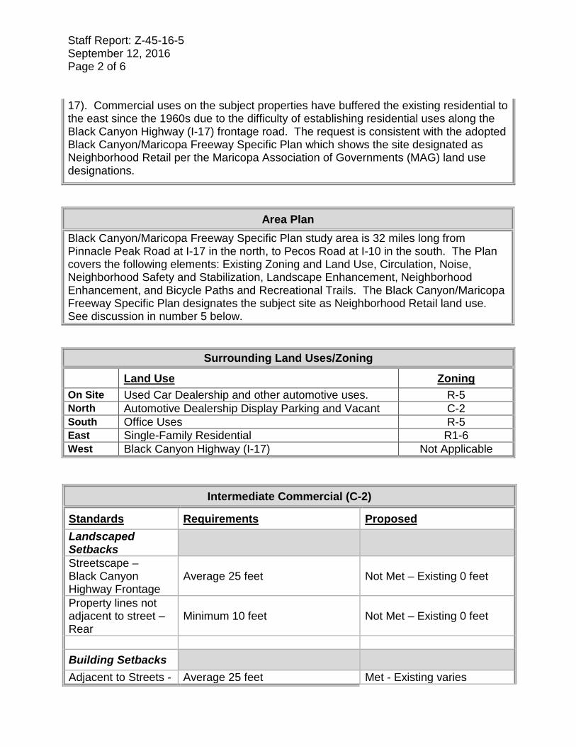
Surrounding Land Uses/Zoning Land Use Zoning On Site Used Car Dealership and other automotive uses. R-5 North Automotive Dealership Display Parking and Vacant C-2 South Office Uses R-5 East Single-Family Residential R1-6 West Black Canyon Highway (I-17) Not Applicable
Intermediate Commercial (C-2)
Standards Requirements Proposed Landscaped Setbacks
Streetscape – Black Canyon Highway Frontage
Average 25 feet Not Met – Existing 0 feet
Property lines not adjacent to street – Rear
Minimum 10 feet Not Met – Existing 0 feet
Building Setbacks Adjacent to Streets - Average 25 feet Met - Existing varies

Staff Report: Z-45-16-5 September 12, 2016 Page 3 of 6 Black Canyon Highway Frontage Not Adjacent to Street 10 feet Met - Existing varies
Lot Coverage 50% maximum Met – 8.78% Building Height 30 feet maximum Existing Not Shown Background/Issues/Analysis SUBJECT SITE (REQUEST) 1. This is a request to rezone 1.18 acres located Approximately 183 feet south of the
southeast corner of Black Canyon Highway (I-17) and Glendale Avenue. The request would rezone the subject parcels from R-5 (Multiple Family Residential) to C-2 (Intermediate Commercial) to allow commercial, office, and retail uses. The proposal will utilize the existing buildings on the site.
2. Rezoning case Z-SP-6-16-5 is a companion case running concurrently with this request. Z-SP-6-16-5 is a request for a Special Permit to allow new and used motor vehicle dealership and all underlying C-2 uses located on the northern most parcel (Lot 4) of the subject site and the parcel directly north (Lot 3).
GENERAL PLAN 3. The General Plan land use designation for the subject site is Residential 3.5-5
du/acre. The request is not in conformance with the General Plan designation however, the subject site is less than 10 acres and therefore does not require a General Plan Amendment.
SURROUNDING ZONING AND LAND USE 4. The subject site is currently
developed and utilized with a used car dealership as well as other automotive uses. To the north is an automotive vehicle display parking and an undeveloped property along Glendale Avenue. To the south are multifamily residential uses and to the east are single family residential uses. To the west is the North Black Canyon Highway (I-17).
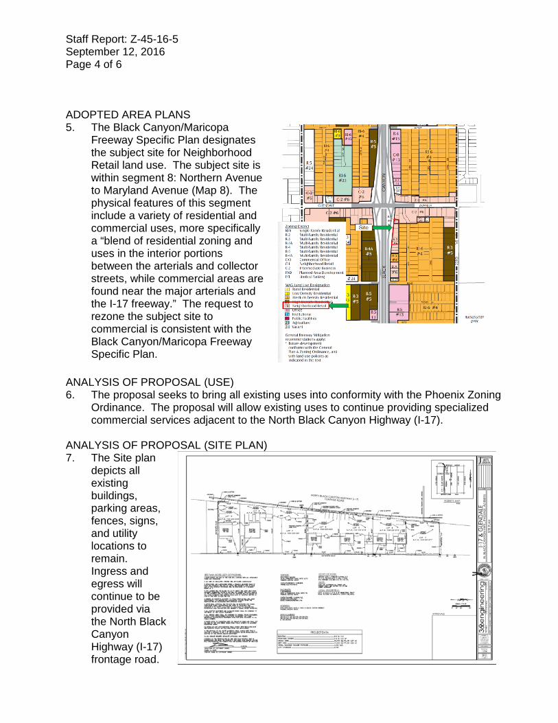
Staff Report: Z-45-16-5 September 12, 2016 Page 4 of 6 ADOPTED AREA PLANS 5. The Black Canyon/Maricopa
Freeway Specific Plan designates the subject site for Neighborhood Retail land use. The subject site is within segment 8: Northern Avenue to Maryland Avenue (Map 8). The physical features of this segment include a variety of residential and commercial uses, more specifically a “blend of residential zoning and uses in the interior portions between the arterials and collector streets, while commercial areas are found near the major arterials and the I-17 freeway.” The request to rezone the subject site to commercial is consistent with the Black Canyon/Maricopa Freeway Specific Plan.
ANALYSIS OF PROPOSAL (USE) 6. The proposal seeks to bring all existing uses into conformity with the Phoenix Zoning
Ordinance. The proposal will allow existing uses to continue providing specialized commercial services adjacent to the North Black Canyon Highway (I-17).
ANALYSIS OF PROPOSAL (SITE PLAN) 7. The Site plan
depicts all existing buildings, parking areas, fences, signs, and utility locations to remain. Ingress and egress will continue to be provided via the North Black Canyon Highway (I-17) frontage road.

Staff Report: Z-45-16-5 September 12, 2016 Page 5 of 6 8. Future development and/or redevelopment of the subject properties shall conform to
section 623 Commercial C-2 District standards of the Phoenix Zoning Ordinance. Buildings with a maximum height of two (2) stories (or 30’) shall have an average 25-foot setback adjacent to streets and a 50-foot setback when adjacent to R1-6. The subject properties’ proximity to single family residential limits their ability to develop at the maximum height allowable while conforming to the building setbacks established in the C-2 District of the Phoenix Zoning Ordinance. These standards ensure that development will be compatible in scale and intensity to adjacent zoning districts. As a result of these standards staff has no recommended stipulations.
WATER 9. The City of Phoenix Water Services Department has noted the potential need to up
size existing water and sewer infrastructure mains so that any remodels or new buildings will be able to meet domestic and fire code requirements.
FIRE 10. No fire code issues are anticipated with this case and the site and/or buildings shall
comply with the Phoenix Fire Code. FLOODPLAIN 11. The City of Phoenix Floodplain Management division of the Street
Transportation Department has determined that this parcel is not in a Special Flood Hazard Area (SFHA), but is located in a Shaded Zone X, on panel 1740 L of the Flood Insurance Rate Maps (FIRM) dated October 16, 2013.
ARCHAEOLOGY 12. No known archaeological work is necessary for this project. In the event
archaeological materials are encountered during construction, all ground disturbing activities must cease within 10-meters of the discovery and the City of Phoenix Archaeology Office must be notified immediately and allowed time to properly assess the materials.
OTHER 13. Development and use of the site is subject to all applicable codes and ordinances.
Zoning approval does not negate other ordinance requirements. Other formal actions such as, but not limited to, zoning adjustments and abandonments, may be required.
Findings 1. The proposal is compatible with the existing commercial uses along Glendale Avenue. 2. The request is consistent with the Maricopa Association of Governments (MAG) land
use designation of Neighborhood Retail in the adopted Black Canyon/Maricopa Freeway Specific Plan.

Staff Report: Z-45-16-5 September 12, 2016 Page 6 of 6 3. The proposal will bring existing uses into conformance and continue to allow
specialized commercial services adjacent to the North Black Canyon Highway (I-17). Stipulations Staff has no recommended stipulations. Writer Joél Carrasco September 12, 2016 Team Leader Joshua Bednarek Attachments Zoning sketch Aerial Site plan dated September 09, 2016

* Maximum Units Allowed with P.R.D. Bonus
APPLICANT'S NAME:
DATE:REVISION DATES:
REQUESTED CHANGE:
GROSS AREA INCLUDING 1/2 STREETAND ALLEY DEDICATION IS APPROX. AERIAL PHOTO &
QUARTER SEC. NO.ZONING MAP
MULTIPLES PERMITTED CONVENTIONAL OPTION * UNITS P.R.D. OPTION
FROM:
TO:
NORTHERN AVE
GLENDALE AVE
BETHANY HOME RD
CAMELBACK RD
35TH
AVE
27TH
AVE 19
THAV
E
7TH A
VE
43RD
AVE
7ST A
VE
I-17
APPLICATION NO.
Withey Morris PLCZ-45-16
1.18 Acres
8/4/16
QS 22-23 I-7
ALHAMBRA VILLAGEZ-45-16
N 23R
D AVE
W GLENDALE AVE
N 26T
H AVE
W LAWRENCE RD
W LAMAR RD
W OCOTILLO RDN
23RD
LN
N 24T
H AVE
N BL
ACK C
ANYO
N HW
Y E
N 26
TH D
R
N 23
RD D
R
N 25
TH D
R
N 24
TH D
R
70327034 7033
7018 7017
70207021
222570257030
2217
6738
6744
6804
6808
6818
6824
6838
23012311
2302 22602260
2250
70122260
2601
6701 260226082614 2538 2534 2526
67076711 6710
2617 2613 2607 2601
6713 6714
67242624 2618 2614 2608
2602 6727
2345 2341 2331 2325 2321 2315 2311
6702 6703
6710 6715
6724 6719
6730 6727
2520 2501 6633 2405 2401
25222518 2512 2502
6701 6702 6701
67056710 6709
671167156716
6713 6717
6722 672167216721
6728 67276725
6731
2617 2617 2601
2601 2551
6702
6714
6718
6728
2305 23016655
7034
7030
7030
7018
7010
7035
7027
7025
7015
7011
6738
67416742
6745 6744
675167506751
68016806 6805
6809
6814 68116815
6820 68236821
6827 6832 6829
68346834
6831
23292345 2319
23307002
2514
24022428
7010 70157015
7021 7022 7021
7023
7027
70287027
7027
7031 7038 70297031 7025 7040 7039
2515
6801
2515
6733
6735
6739
67416747
6801
6809
6801
6827
6835
6845
6845
2415
6734
6740
6746
6752
6802
6810
6816
6822
6832
6828
2401
6733
6739
7030
67362625 2619 2613 2609 2601
6737
6746 6748
2626 2620 2614 2610 2602
6750
6813
68066805
68146805
6816
6819
7038
26096822 6823
2647
68256834
6836
25452635 2531 2525
2650
2622
2602
25287015
70217022
7028 7027 7022
70317032 7026
7037
C-O
R-5
P-1 *Z-41-89R1-6
R-3
P-1 *Z-71-89
R-5
C-2
R-4
R-5
R1-6
R1-6
R1-6
R-3
P-1
R-4P-1
R-5
PAD-8
R-4A
C-2 * Z-118-05
C-O Z-39-81
P-1 * Z-14-03
300 0 300150Feet
R-5 (1.18 a.c.)
R:\IS_Team\Core_Functions\Zoning\sketch_maps\2016\Z-45-16.mxd
R-5C-2 16
51 6120
C-2, (1.18 a.c.)
CITY COUNCIL DISTRICT: 5
I

* Maximum Units Allowed with P.R.D. Bonus
APPLICANT'S NAME:
DATE:REVISION DATES:
REQUESTED CHANGE:
GROSS AREA INCLUDING 1/2 STREETAND ALLEY DEDICATION IS APPROX. AERIAL PHOTO &
QUARTER SEC. NO.ZONING MAP
MULTIPLES PERMITTED CONVENTIONAL OPTION * UNITS P.R.D. OPTION
FROM:
TO:
NORTHERN AVE
GLENDALE AVE
BETHANY HOME RD
CAMELBACK RD
35TH
AVE
27TH
AVE 19
THAV
E
7TH A
VE
43RD
AVE
7ST A
VE
I-17
APPLICATION NO.
Withey Morris PLCZ-45-16
1.18 Acres
8/4/16
QS 22-23 I-7
ALHAMBRA VILLAGEZ-45-16
N 23R
D AVE
W GLENDALE AVE
N 26T
H AVE
W LAWRENCE RD
W LAMAR RD
W OCOTILLO RDN
23RD
LN
N 24T
H AVE
N BL
ACK C
ANYO
N HW
Y E
N 26
TH D
R
N 23
RD D
R
N 25
TH D
R
N 24
TH D
R
70327034 7033
7018 7017
70207021
222570257030
2217
6738
6744
6804
6808
6818
6824
6838
23012311
2302 22602260
2250
70122260
2601
6701 260226082614 2538 2534 2526
67076711 6710
2617 2613 2607 2601
6713 6714
67242624 2618 2614 2608
2602 6727
2345 2341 2331 2325 2321 2315 2311
6702 6703
6710 6715
6724 6719
6730 6727
2520 2501 6633 2405 2401
25222518 2512 2502
6701 6702 6701
67056710 6709
671167156716
6713 6717
6722 672167216721
6728 67276725
6731
2617 2617 2601
2601 2551
6702
6714
6718
6728
2305 23016655
7034
7030
7030
7018
7010
7035
7027
7025
7015
7011
6738
67416742
6745 6744
675167506751
68016806 6805
6809
6814 68116815
6820 68236821
6827 6832 6829
68346834
6831
23292345 2319
23307002
2514
24022428
7010 70157015
7021 7022 7021
7023
7027
70287027
7027
7031 7038 70297031 7025 7040 7039
2515
6801
2515
6733
6735
6739
67416747
6801
6809
6801
6827
6835
6845
6845
2415
6734
6740
6746
6752
6802
6810
6816
6822
6832
6828
2401
6733
6739
7030
67362625 2619 2613 2609 2601
6737
6746 6748
2626 2620 2614 2610 2602
6750
6813
68066805
68146805
6816
6819
7038
26096822 6823
2647
68256834
6836
25452635 2531 2525
2650
2622
2602
25287015
70217022
7028 7027 7022
70317032 7026
7037
C-2 * Z-118-05
C-O Z-39-81
P-1 * Z-14-03
C-O
R-5
P-1 *Z-41-89R1-6
R-3
P-1 *Z-71-89
R-5
C-2
R-4
R-5
R1-6
R1-6
R1-6
R-3
P-1
R-4P-1
R-5
PAD-8
R-4A
300 0 300150Feet
R-5 (1.18 a.c.)
R:\IS_Team\Core_Functions\Zoning\sketch_maps\2016\Z-45-16.mxd
R-5C-2 16
51 6120
C-2, (1.18 a.c.)
CITY COUNCIL DISTRICT: 5
I


![I Z k i h j l j h ] j Z f f u - schkola52-45.narod.ruschkola52-45.narod.ru/otdix/programma.pdf · I Z k i h j l j h ] j Z f f u № № п/п Полное название программы](https://img.pdfslide.us/doc/110x75/6029be33a7efe411866df13c/i-z-k-i-h-j-l-j-h-j-z-f-f-u-schkola52-45narodruschkola52-45narodruotdix.jpg)