Embed Size (px)
Citation preview

ITEM: 2013-I-B2 April 3, 2015

This page left intentionally blank

Plan Amendment 2013-I-B2 Staff Report
STAFF REPORT FOR SEVEN CORNERS COMMUNITY BUSINESS CENTER PLAN AMENDMENT 2013-I-B2
BACKGROUND The Seven Corners Community Business Center (CBC) Special Study originated from two community visioning workshops held in the summer of 2012, coordinated by the Office of Mason District Supervisor Penelope A. Gross, the Fairfax County Office of Community Revitalization, and the Department of Planning and Zoning, to discuss the future of Seven Corners and possible revitalization efforts. Following these meetings, in the fall of 2012, Supervisor Gross appointed the Seven Corners Land Use and Transportation Task Force to review the findings of the visioning forums, and to develop recommendations for the future of the Seven Corners area. The task force included representatives from Mason District, representatives of land owners in the CBC, and members of the Seven Corners community. Two additional working groups were also formed to focus on specific areas of community interest. The members of these groups are listed below in Table 1.
Table 1
Of the two working groups, the Seven Corners Quality of Life Working Group was tasked with identifying and exploring solutions for more immediate quality of life issues in the study area. Recommendations that addressed eliminating illegal signage; improving residential and commercial property maintenance; improving overall cleanliness and maintenance of the area; ensuring that the pedestrian bridge is safe, attractive and well-maintained; enhancing streetscape, landscaping, and pedestrian amenities; improving and maintaining bus stops; and, fostering greater cohesiveness and local commitment from Baileys Crossroads and Seven Corners were completed in May 2013.
John Thillmann (Co-Chair) Mary Ellen Ward (Co-Chair)
Nathan Bath Dick KnappVincent Burke Jim McIlvaineDevin Corini Karl Moritz
Jim Edmondson Mark SilverwoodMarty Faga Blake SmithPatrick Hoar Steve TillmanIqbal Khaiy
Seven Corners Quality of Life Working Group
Seven Corners Connectivity Working Group
Kay Cooper Richard ChestonMaria Flores Ben CooperMitzi Romiti Roger HoskinCarol Turner Jan Reitman
Nancy Vorona Doug SmithSteve Yaffe
Seven Corners Land Use and Transportation Task Force
Evelyn Haught (Secretary)
Page 1 of 97

Plan Amendment 2013-I-B2 Staff Report
The Seven Corners Connectivity Working Group provided recommendations related to improving pedestrian/bicycle marking, signage, bicycle facilities, bus service and infrastructure, pedestrian, bicycle and transit supportive facilities, and other transportation improvement recommendations. This group also completed their work in the spring of 2013. Concurrent with the efforts of these two working groups, the Seven Corners Land Use and Transportation Task Force drafted a vision statement and guiding principles for Seven Corners. These ideas were used to define and guide a planning charrette; a design workshop in which an alternative pattern for future development was developed that addressed housing, parks, retail and office uses, with an enhanced street grid for greater connectivity within Seven Corners. The planning charrette focused on Land Units A, B, C and D (refer to Map 1). On October 29, 2013, the Board of Supervisors authorized PA 2013-I-B2 to formally consider incorporating the recommendations of the Seven Corners Land Use and Transportation Task Force into the Comprehensive Plan to include evaluating areawide recommendations and reviewing the transportation network in the area. Following the planning charrette, the focus of the study was concentrated in a smaller area comprising the Willston, Seven Corners Shopping Center and Sears areas, which are referred to as opportunity sites. A two-phased transportation study was also conducted, in collaboration with and to support the work of, the Seven Corners Land Use and Transportation Task Force. The first phase of the transportation study focused on identifying existing transportation conditions in the Seven Corners area. The second phase, which included a transportation design charrette with the Seven Corners Task Force, community members and staff from Fairfax County and the City of Falls Church, focused on identifying a concept for a future Seven Corners interchange and surrounding roadway network. Both phases were guided by a transportation study, input from the Seven Corners Task Force, input from the community and from surrounding jurisdictions. The 15 member task force continued its work, meeting a total of 29 times, to develop a form-based Comprehensive Plan for the Seven Corners CBC in consultation with staff. The proposed Plan provides development flexibility by describing envisioned character through building scale, height and massing, in lieu of floor area ratios and dwelling units per acre. Improving pedestrian, bicycle and vehicular connectivity is also stressed in the proposed Plan through recommendations to both improve the overall transportation network and create welcoming environments through urban design and streetscape treatments. On September 11, 2014, Supervisor Gross extended the timeline for the study by an additional four months to permit further, in-depth discussion about the future of Sub-unit C-2 (the Sears area), because the task force did not come to a consensus on a recommendation for this opportunity site. Charged with focusing specifically on this area (proposed Land Unit C), Supervisor Gross created the Opportunity Area C Special Working Group to develop land use recommendations for the future of this area. The members of this group are listed in Table 2. The special working group included representatives from adjacent neighborhoods including Buffalo Hills, Ravenwood, Ravenwood Park, Lake Barcroft, Lee Boulevard Heights, Seven Oaks II, Sleepy Hollow, and Sleepy Hollow Manor. The 10 member working group was committed to considering the concerns of the neighboring communities.
Page 2 of 97

Plan Amendment 2013-I-B2 Staff Report
Table 2
The special working group conducted several community meetings and design workshops. Specific issues that arose during the process were limiting vehicular and pedestrian connections to neighboring streets, protecting the character of adjacent residential neighborhoods, possible realignment or closure of Juniper Lane, and developing the right amount and mix of land uses on new Land Unit C (refer to Map 2). The special working group concluded its work in March of 2015. The staff report addresses how the combined task force and working group refined long-term vision can be balanced with the area’s new transportation network, transit services, schools and parks. LOCATION AND CHARACTER OF THE CBC The Seven Corners CBC is a gateway to Fairfax County from both Arlington County and the City of Falls Church. The CBC is centered on the intersection of three regional commuter routes: Arlington Boulevard (Route 50), Leesburg Pike (Route 7), and Wilson Boulevard/Sleepy Hollow Drive. The convergence of these major routes forms the multi-cornered interchange from which the CBC derives its name. The Seven Corners CBC is a vibrant and culturally diverse community that includes approximately 218 acres. Dominated by the Seven Corners Shopping Center, Willston I and Willston II Shopping Centers, and The Corner at Seven Corners Shopping Center, the CBC also contains two high-rise office towers, lower scale office buildings, and a variety of residential uses including garden-style complexes and townhouse neighborhoods. The Seven Corners Shopping Center is a dominant focal point of the area, and is considered both locally and regionally as the “center” of the Seven Corners CBC. The automobile orientation of this landmark, the complicated Seven Corners interchange itself, and the concentration of other highway-oriented commercial development pose significant challenges to creating a strong sense of place. CHARACTER OF THE SURROUNDING AREA Surrounding the CBC are stable low-density residential communities of Sleepy Hollow, Buffalo Hills, Sleepy Hollow Manor, Ravenwood, Ravenwood Park, Hillwood, and Lee Boulevard Heights. A number of retail centers, such as the Vietnamese-centric Eden Center, automobile sales and service, and office uses are located in the City of Falls Church which, with Arlington County, forms the northern and eastern boundaries of the CBC. ADOPTED COMPREHENSIVE PLAN TEXT The Comprehensive Plan text for the subject area is primarily contained in the Baileys Planning District, Seven Corners Community Business Center, Area I volume of the 2013 Edition of the Comprehensive Plan.
Marty Faga (Chair) Catriona McCormackGeorge Fitchko Karl Moritz
Jan Keyes Duane MorseBill Lecos Blake Smith
Marty Machowsky Margaret Van Voast
Opportunity Area C Special Working Group
Page 3 of 97

Plan Amendment 2013-I-B2 Staff Report
Comprehensive Plan recommendations for the Seven Corners CBC are organized by land units and sub-unit areas as shown on Map 1 (Current Land Units and Sub-units Map). Table 3 summarizes the current recommendations for land unit and sub-unit areas within the CBC by land use, building height limitations, and intensities/densities of development expressed in floor area ratio (FAR) and dwelling units per acre (du/ac). These planned uses and intensities/densities are supported by specific development conditions relating to design, transportation and other elements. References to the Seven Corners CBC are also found in the overview section of the Baileys Planning District, and portions of two community planning sectors within the Jefferson Planning District: J1 Hillwood and J2 Sleepy Hollow; and portions of three community planning sectors within the Baileys Planning District: B1 Willston, B2 Glen Forest, and B5 Barcroft. Plan text may be obtained from the Department of Planning and Zoning at 703-324-1380 or may be accessed at:
http://www.fairfaxcounty.gov/dpz/comprehensiveplan/area1/baileys.pdf and http://www.fairfaxcounty.gov/dpz/comprehensiveplan/area1/jefferson.pdf
Map 1
Page 4 of 97

Plan Amendment 2013-I-B2 Staff Report
Table 3
Land Unit/ Sub-unit
A-1
A-3 Community-serving retail and office uses at its current intensity (approximately .30 FAR).
B-2
Current Comprehensive Plan Text Recommendations
B-4
Public facilities with an option for community-serving office or retail use up to .50 FAR with conditions that public facilities uses are incorporated.
Multifamily residential up to 16-20 du/ac.Neighborhood-serving retail use at its current intensity (up to .25 FAR).
A-2
B-3
A-4
Option for retail and office mixed use up to .70 FAR if whole sub-unit is consolidated.
Multifamily residential up to 16-20 du/ac.Neighborhood-serving retail uses up to .25 FAR.Residential use at its current density (vacant).
Retail use up to .50 FAR, with an option for hotel use up to 90 feet in height.Multifamily residential up to 16-20 du/ac.Neighborhood-serving retail use up to .35 FAR.Hotel use at its current intensity (approximately .50 FAR).Townhouse office use up to .35 FAR.
Neighborhood-serving retail use up to .35 FAR with an option for up to .50 FAR office and retail mix if fully consolidated.
B-1
Office use maintaining residential character up to .25 FAR, with an option of townhouse office use up to .35 FAR.
D-2
C-2
Retail, office and community-serving office uses, with an option for office use up to .50 FAR and .70 FAR with successive consolidation.Public facilities use.
C-1
Retail use at its current intensity (.45 FAR).Office use at its current intensity (.50 FAR).
Neighborhood-serving retail uses at its current intensity (approximately .22 FAR) with an option for retail and/or office use up to .50 FAR.Mixed use at its current intensity (approximately 1.14 FAR).E
Neighborhood-serving retail or office use up to .50 FAR, with an option for retail and office use up to .70 FAR.
D-1
Community-serving office use at its current intensity (approximately .45 FAR).Public facilities use at its current intensity (approximately .65 FAR).
Page 5 of 97

Plan Amendment 2013-I-B2 Staff Report
PROPOSED PLAN AMENDMENT AND ANALYSIS This discussion summarizes recommended Comprehensive Plan changes for the Seven Corners CBC, with focus on the general approach and major concepts related to the proposed form-based Plan. Detailed recommendations and updated information are shown as proposed Plan text in the section entitled “Recommended Plan Amendment.” Vision The overall vision for the Seven Corners CBC is to create a cohesive whole of its many neighborhoods and commercial centers. The sub-areas are separated by two major roadways, Arlington Boulevard and Leesburg Pike, which act as barriers to the physical integration of the CBC. The Plan concept envisions three densely-developed Opportunity Areas (refer to Map 2), each with a different character to serve the greater Seven Corners area and beyond. The three Opportunity Areas will be linked together via a new “spine road” that traverses the CBC from Wilson Boulevard over Arlington Boulevard to Leesburg Pike. As a major north-south pedestrian and vehicular connection, the spine road will act as the central organizing construct for redevelopment in the Opportunity Areas. Together with a new grid of streets that will accompany the redevelopment of the Opportunity Areas, the spine road is planned to provide new options for navigating Seven Corners (Map 3).
Map 2
Page 6 of 97

Plan Amendment 2013-I-B2 Staff Report
Map 3
Each Opportunity Area is intended to possess a distinct character, but is planned to function as part of a larger whole through linkages to one another and through a network of public open spaces. The Town Center is the site of the Seven Corner Shopping Center. It is envisioned to have the greatest development intensity and the tallest buildings. Mixed-use development consisting of residential, retail, office and hotel uses is planned to be organized around a large, central plaza that will serve as the main public gathering place for the greater Seven Corners community. The Willston Village Center is currently the site of the Willston Multicultural Center, surface parking, the Willston I Shopping Center, the Seven Corners Apartments and the East Falls Church Apartments. This area is envisioned to be more neighborhood-serving and smaller in scale than the Town Center, and is planned to be organized around a village main street where ground-floor retail, an urban plaza, outdoor dining areas, and community uses will be concentrated to create a lively, pedestrian-friendly environment. This area may also be the site of a new public facility that would provide services to the community. However, to respond to continued community concerns, a revised recommendation for Willston Multicultural Center site is also provided as an alternative. This guidance would expand public facility uses on the site to include educational, cultural, governmental and/or human services use to support the local community. The purpose of the new alternative is to provide the Planning Commission and the Board of Supervisors with land use options during their deliberations at public hearing. These options for consideration are located on pages 54, 90 and 91 of the draft Plan text in this report. Lastly, the Leesburg Pike Village, site of the Sears department store, an office building and large parking deck, is envisioned to be a mixed-use village that provides the greatest building height along Leesburg Pike, and tapers in height and adjusts in building type to create an appropriate transition to the adjacent single-family neighborhoods. Planned for this land unit is a smaller
Seven Corners Community Business Center Framework Plan
Page 7 of 97

Plan Amendment 2013-I-B2 Staff Report
village main street coupled with an abundant amount of open space along with development conditions that will preserve the existing character of the neighboring streets and community. There are two other distinct planning areas, as previously shown on Map 2, which are the Transitional Areas and the Minimum Change Area. The Transitional Areas are expected to maintain existing uses or experience only moderate change and a more traditional, intensity-based planning approach is recommended. The Minimal Change Area is where existing uses are expected to be retained. However, if consistent with the overall goals of Seven Corners, parcels in Transitional Areas may be considered for additional intensity through a concurrent Comprehensive Plan amendment and rezoning application. General Approach for Form-Based Plan The proposed Plan for the Seven Corners CBC moves away from traditional techniques in favor of a form-based approach to incentivize redevelopment in the Opportunity Areas by emphasizing the scale, land use relationships, urban design principles and function of future development while providing flexibility with respect to specific land uses and intensities. Specifically, building form, design, and height guidance is provided in the plan to describe the development potential of properties within the Opportunity Areas in lieu of more traditional intensity limitations. As such, the amount of development allocated to any given property or assemblage will be guided by building height (refer to Map 4), the allotted total square footage for a sub-unit (refer to Table 4), urban design guidance, parking requirements, street connections and other criteria which may further affect the buildable area. This approach recognizes that intensity alone does not ensure good urban design or building form. With this form-based approach, developers will have the flexibility to design a project which meets their needs, while conforming to the vision of the community.
Table 4
The redevelopment of the Seven Corners CBC is intended to be achieved using the proposed form-based approach to guide the general use, intensity, and distribution of development. This flexible approach would be promoted in two ways. First, in lieu of single land-use recommendations, the proposed Plan provides for multiple uses and mixed use development in
Residential (DU)
Nonresidential (sf)
Residential (sf)1 Retail (sf)
Office/Hotel (sf) TOTAL (sf)
Sub-unit A-1 0 1,200,000 0 2 0Sub-unit A-2 0 1,000,000 0 0Sub-unit A-3 134,358 560,000 191,000 200,000
Town Center Land Unit B 0 630,199 2,450,000 625,000 725,000 3,800,000Leesburg
Pike Village Land Unit C 0 265,869 404,000 3 85,000 4 50,000 5 539,000
589 1,030,426 5,614,000 901,000 975,000 7,490,000
6 Numbers based on 2012 Seven Corners CBC Existing Conditions Report.
5 There is an additional option in Land Unit C to permit up to 100,000 sf of additional non-residential use with a commensurate reduction in residential square footage to 304,000 sf, and not to exceed the overall land unit cap.
4 Approximately 40,000 sf for retail, and approximately 45,000 sf for theater/entertainment retail.
3 Up to 129,000 sf for townhouse single-family residential, up to 275,000 sf for multi-family residential.
TOTAL1 Assumed Residential Unit Size: 1,000 sf per multifamily unit; 2,000 sf per townhouse unit.2 There is an additional option in Sub-unit A-1 to permit up to 190,000 sf of retail along the planned spine road with a commensurate reduction in residential square footage to 1,010,000.
Opportunity AreaExisting Development
6 Redevelopment Option
Willston Village Center
589 3,151,000
Page 8 of 97

Plan Amendment 2013-I-B2 Staff Report
the land units of the Opportunity Areas. Under the current Plan baseline land use recommendations for the CBC, most sub-units are limited to one use, for example, community-serving retail use. Second, the proposed Plan utilizes building form, design, and height to describe the development potential of properties within the CBC. As a result, the approximate overall total build-out for the entire CBC is 10.3 million square feet, with a general allocation of square footage among the different land uses as indicated in Table 5.
Table 5
Land Use Building Heights
Map 4
Proposed planned building heights are recommended to be highest within the Opportunity Areas, and generally taper down to the residential communities within and adjacent to the CBC. The tallest buildings are recommended to be located along or near Wilson Boulevard, Arlington Boulevard, and Leesburg Pike, as the wider width of the right-of-ways can best accommodate the
Land UsesOpportunity
AreaTransitional
AreaMinimum
Change Area TOTAL
Residential (sf) 1 5,614,000 615,000 494,000 6,723,000Office/Hotel (sf) 975,000 941,000 0 1,916,000
Retail (sf) 901,000 659,000 0 1,560,000Public Facilities (sf) (see Plan text) 108,000 0 108,000
TOTAL (sf) 7,490,000 2,323,000 494,000 10,307,000
Seven Corners CBC Estimation of Development Potential by Planning Area
1 Assumed Residential Unit Size: 1,000 sf per multifamily unit; 2,000 sf per townhouse unit.
Page 9 of 97

Plan Amendment 2013-I-B2 Staff Report
planned height. The additional height, particularly in the Town Center, will help create focal points that emphasize the core areas and create the opportunity for a signature gateway building. Further, the tallest buildings and most intense development should be located closest to transit opportunities. Those portions of the Opportunity Areas that border lower scale residential uses should transition to lower heights consistent with Map 4 to avoid impacts of scale on adjacent residential areas. Land Use and General Guidelines In general, multiple uses and mixed-use development are recommended throughout the Opportunity Areas. Residential, commercial, office, hotel, and retail uses or a mixture of those uses are expected within the Seven Corners CBC. The proposed Plan also encourages institutional, cultural, recreational, and governmental uses that enrich community life, improve the provision of public services, and enhance the area’s business competitiveness. The proposed Plan amendment supports alternative uses (for example, hotels) which may not be specifically recommended in an area, but which may be consistent with the vision of the Plan. Uses that detract from the vision of a vibrant and urban CBC are discouraged in the proposed Plan amendment. These include, but are not limited to, storage and distribution, auto-oriented and drive-through uses, and outdoor sales and storage. Specific guidance is also proposed for each sub-unit and is intended to complement other Plan guidance. The proposed Plan amendment recommends that all development proposals with a residential component should provide affordable housing. In Sub-units A-1 and A-2, all existing units are considered affordable. Therefore a 1:1 replacement of all units is expected within the redevelopment concept. To the extent feasible, the units should accommodate universal design. Projects with a residential component in Sub-unit A-3 and Land Unit B may be granted redevelopment potential if 15 percent of the residential units in new developments are affordable to households with incomes ranging up to 120 percent Area Median Income (AMI) and 12 percent in Land Unit C. The option for the redevelopment includes any bonus units associated with the Workforce Housing policy. For all redevelopment proposals, parcel consolidation and coordinated development and phasing are encouraged as a way to achieve the planning objectives for the CBC. Development and redevelopment is expected to occur over time and be phased. It is particularly important when there is more than one owner of a sub-unit to coordinate development plans and phasing so that current and future phases work cohesively and implement a coordinated concept plan. Urban Design The proposed Plan includes urban design recommendations which provide guidance regarding the physical form of development in the Seven Corners CBC. The recommendations specifically address street types and design, as well as building and site design. Street types in Seven Corners have been identified, with a conceptual overview of each type’s functionality, cross-section, scale, modal mix, and character. The cross-sections for each street type contain flexibility to be able to respond to particular needs in different locations. Within Seven Corners, pavement cross-sections should be context-sensitive and fit into an urban environment, while addressing safety, operations, and capacity needs. Although typical street cross-sections are included in the proposed Plan amendment, final street designs may include some variations, such as lane width, sidewalk width, or building setback to reflect the changing context of the street as it passes through Seven Corners.
Page 10 of 97
Plan Amendment 2013-I-B2 Staff Report
Building and site design recommendations are also included to promote an urban, pedestrian-friendly pattern of development. Guidance regarding build-to lines, bulk and massing, fenestration, parking design, and building height, among others, are provided. If designed well, the combination of public and private spaces creates attractive and functional places to live, work, and shop. High standards for innovative architecture and landscape architecture will create a unique aesthetic and identity within Seven Corners. Development Options The proposed Seven Corners CBC Plan includes two development levels. The proposed base development level generally reflects the existing character of development. Every sub-unit has a base development level, but only the Opportunity Areas are proposed to have a redevelopment level, which provides an increase in building height and intensity in exchange for certain uses, facilities, or other elements which are deemed appropriate public benefits. The proposed increase in building height yields increased development potential for those sites, although other Plan and urban design guidelines also apply. Realizing the proposed redevelopment option will be based on achievement of conditions that include, but are not limited to the following:
- Coordinated development and phasing so that current and future phases work cohesively and implement a cohesive concept plan;
- Contributions to the transportation network to improve pedestrian, bicycle and vehicular circulation on existing and planned roadways;
- Conformance with urban design and urban street guidelines to achieve the desired building form, type and placement of buildings, and specified streetscapes;
- Public parks and recreation areas to be provided with the initial phase of development. Contributions that exceed county urban parks framework recommendations may also be considered;
- Monetary contributions or land for identified public facilities that are needed to accommodate the future development of the Seven Corners CBC. Such facilities may include, but are not limited to a government, education, cultural, or community center and/or transit facility;
- Enhanced green building certification such as Leadership in Energy and Environmental Design (LEED), or the equivalent;
- Compatibility with adjacent land uses that includes the tapering of building height and buffering as needed to provide a transition to lower density neighborhoods, and/or physical connections and complementary architectural style when adjacent to higher intensity uses; and
- Adherence to affordable housing recommendations for each land unit. Transportation The Seven Corners CBC is located at the intersection of two major thoroughfares in Fairfax County, Arlington Boulevard and Leesburg Pike, both of which are heavily utilized by commuters that travel through the area to access major employment centers in Arlington, Alexandria and the District of Columbia, as well as local traffic accessing the retail and residential uses in the area. As previously stated, the existing land uses in the Seven Corners
Page 11 of 97

Plan Amendment 2013-I-B2 Staff Report
CBC are suburban/single use in nature, widely separated from each other, and structured to accommodate vehicular rather than pedestrian access. The vast majority of trips to, from, within, and through Seven Corners are made using private automobiles. The intent of the proposed Plan amendment is to foster revitalization of the area into a vibrant, walkable, transit-oriented Fairfax County community. To achieve this goal, the Seven Corners Comprehensive Plan must serve the needs of both the people who will work, live, and recreate within the Seven Corners area and those that will commute through. In support of changing this disconnected, auto-oriented area into a healthy, vibrant, walkable, transit oriented center, while also supporting the land-use recommendations in the proposed Comprehensive Plan, the Fairfax County Department of Transportation completed a two-phase transportation analysis of the Seven Corners roadway network with an emphasis on improving the interchange conditions. Both Phase I and Phase II analyses are available on the Fairfax County Office of Community Revitalization’s Seven Corners Visioning website here: http://www.fcrevit.org/baileys/7corners.htm. Phase I examined the existing conditions in the Seven Corners area and provided the baseline for Phase II. Phase I focused on measuring existing traffic conditions and was used to gain an understanding of the transportation challenges in the Seven Corners area. Additionally, the origin-destination data, collected as part of Phase I showed where the heaviest flow of traffic is occurring and how people are driving to and/or through the Seven Corners area. These results were used in the Seven Corners Task Force Transportation Charrette that was held in November 2013. The charrette was also attended by staff from Arlington County and City of Falls Church. The purpose of the charrette was to understand task force concerns as well as to brainstorm ideas for improving pedestrian and bicycle movements, the Route 7 and Route 50 roadways, potential new roadway connections, and develop concepts for a new Seven Corners interchange. Since the interchange was a major focus of Phase II, six interchange concepts, based on comments and ideas discussed during the charrette, were developed. These concepts were evaluated using measures of effectiveness. The six concepts were then presented to the task force along with the results of the measures of effectiveness analysis. Three concepts were selected to be advanced, with modifications, for further evaluation. All six concepts were shown to the Virginia Department of Transportation (VDOT) during three meetings with them, held between December 2013 and May 2014, including the recommendation to move forward with three concepts. Phase II used the existing traffic conditions and origin-destination data from the Phase I transportation analysis, and added in the additional density scenarios developed by the Seven Corners Task Force. This land use data, along with a roadway network that included three interchange concepts, was evaluated in Phase II. After receiving concurrence from VDOT and the Seven Corners Task Force, additional study including a pedestrian walkshed analysis, was undertaken for the three remaining concepts. This additional work resulted in the selection of the final recommended roadway network, which includes a concept for a redesigned Seven Corners interchange, as included in the draft Comprehensive Plan text. Based on the analysis and the interchange concept being advanced, the following recommendations are being proposed as part of the Comprehensive Plan Amendment for Seven Corners. Transportation Recommendations for the Comprehensive Plan Amendment (Refer to Map 5 of this staff report for generalized locations, and the Transportation Recommendations Maps in the attached draft Plan for more specific information) Seven Corners Interchange Recommendations
1. A ring road as shown in the Transportation Recommendations Map (Map 5, staff report).
Page 12 of 97

Plan Amendment 2013-I-B2 Staff Report
2. Reconfiguration of the existing interchange to create a four-legged intersection of Leesburg Pike and Wilson Boulevard/Sleepy Hollow Road.
3. One new crossing over Arlington Boulevard, on the west side of the Seven Corners interchange, connecting East Broad Street to Sleepy Hollow Road, with ramps to Arlington Boulevard westbound and from Arlington Boulevard eastbound.
4. Extension of Castle Place, across Sleepy Hollow Road, to connect to the new crossing over Arlington Boulevard on the west side of the Seven Corners interchange.
5. One new crossing over Arlington Boulevard, on the east side of the Seven Corners interchange, connecting the intersections of Roosevelt Boulevard/Wilson Boulevard to Castle Road/Leesburg Pike, with ramps to Arlington Boulevard eastbound and from Arlington Boulevard westbound.
6. Reconfigure Castle Road/Castle Place alignment to connect Castle Place extension to a new Arlington Boulevard crossing to Roosevelt Boulevard/Wilson Boulevard, on the east side of the Seven Corners interchange.
Seven Corners Area Road Recommendations 1. One new bridge over Arlington Boulevard, connecting Willston Drive/the Willston
Village Center area to Leesburg Pike, approximately halfway between the Seven Corners interchange and Patrick Henry Drive, on the east side of the Seven Corners interchange. This crossing will have no ramp connections to and from Arlington Boulevard.
2. Removal of the Arlington Boulevard access roads, on both the north and south sides of Arlington Boulevard, between Patrick Henry Drive and the Seven Corners interchange.
3. An enhanced and better connected road network as shown with the green lines on the Transportation Map in Map 5 of the staff report.
4. Arlington Boulevard widened to six lanes from the Arlington/Fairfax County line to the City of Fairfax.
5. Leesburg Pike improved to six lanes from the City of Falls Church to Columbia Pike accommodating high quality transit.
6. Evaluate the relocation of the vehicular signal on Arlington Boulevard between Manchester Street and Patrick Henry Drive, to address turning movements on Arlington Boulevard associated with high trip generating uses, while minimizing impacts on surrounding residential neighborhoods.
7. Conduct a traffic analysis of the roadway network in the vicinity of Juniper Lane and Patrick Henry Drive. This analysis should identify potential strategies to limit cut-through traffic, as well as reduce possible traffic impacts generated by future development, to the surrounding residential neighborhoods while improving connectivity within these neighborhoods. Options to evaluate should include, but not be limited to, the closing of Juniper Lane, the possible extension of Nicholson Street to Juniper Lane, the realignment of Juniper Lane at its connection to Patrick Henry Drive, and should engage the residential communities in the vicinity of Juniper Lane, Patrick Henry Drive and Nicholson Street to develop final recommendations. Such analysis should identify options to maintain adequate access between Juniper Lane and Patrick Henry Drive to both east and westbound Leesburg Pike without degrading traffic operations on Patrick Henry Drive or Juniper Lane. This analysis should be conducted prior to or concurrent with rezoning applications for properties located within Land Area C, as defined in the Opportunity Areas Section, and is recommended to be completed within one year of plan adoption.
Page 13 of 97

Plan Amendment 2013-I-B2 Staff Report
Map 5
Page 14 of 97

Plan Amendment 2013-I-B2 Staff Report
Urban Street Network Design A Conceptual Functional Classification for the Seven Corners Enhanced Street Network was created and is included in this Plan amendment, to apply context sensitive design principles and elements of complete streets to all existing and new streets in Seven Corners. Functional classification designations included in this Plan amendment are consistent with classifications shown in the Virginia Department of Rail and Public Transit (DRPT) Multimodal System Design Guidelines. It is the intent of Fairfax County to seek approval from VDOT to apply the DRPT design guidelines in the Seven Corners CBC. Table 6 provides a cross-reference of the two classification systems.
Table 6
Note: The cross-references shown in the table above are general in nature. Some variations may occur. The draft Plan supports the creation of a connected network of streets. All street cross sections will include sidewalks or multi-use trails, and will be designed to create an appropriate sense of place. Street elements that can assist in accomplishing a sense of place include: trees and planting strips, rain gardens, special paving materials, and coordinated street furniture, lighting and signage, and public art. The streets will be considered part of the open space system, providing attractive connections within and between districts. The proposed street sections are recommended to be designed as compact streets that allow for all modes of transit while reducing walking distance across intersections. These streets will allow access by all manner of emergency and service vehicles at speeds responding to the street context. A bulleted list of the following street categories are proposed for the Seven Corners CBC. Please see the Proposed Draft Plan Text for further explanation and a map depicting the classifications of the roads.
• Multimodal Through Corridor – Arlington Boulevard (Route 50) • Transit Boulevard – Leesburg Pike (Route 7) • Major Avenues and Avenues – Wilson Boulevard, Sleepy Hollow Road, Patrick Henry
Drive • Local Streets – Other Streets in the Seven Corners CBC (determination made on a case
by case basis)
Mul
timod
al T
ypes
(D
esig
n Sp
eed)
Avenue (25-30 mph)
Fairfax County Functional Classification(Design Speed)
Transit Boulevard (30-35 mph)Boulevard (30-35 mph)
Major Avenue (30-35 mph)
Local Street (25 mph)
Interstate, Freeway, or Expressway (50-70 mph)
Principal Arterial (30-60 mph)
Minor Arterial Type A or B (30-60 mph)
Collector (30-50 mph)
Local Street (20-30 mph)
Multimodal Through Corridor (35-55 mph)
Page 15 of 97

Plan Amendment 2013-I-B2 Staff Report
Schools Existing Facilities Presently, the schools serving the Seven Corners area are Bailey's, Bailey’s Upper, Beech Tree, Glen Forest, and Sleepy Hollow Elementary; Glasgow Middle; and Stuart High Schools. Baileys Upper Elementary School, located at 6245 Leesburg Pike, is the primary Fairfax County Public Schools (FCPS) capital project in this portion of the county. This school provides capacity for approximately 700 students, relieving the Baileys Elementary School, by serving grades 3-5. As a result the current Baileys Elementary School now serves grades K-2. At the middle school level, overcrowding is projected and could potentially be addressed through program changes. At the high school level, capacity enhancements would be needed to address projected capacity deficits. Assessment of Land Use Alternatives The assessment of land use alternatives consists of low and high ranges, as illustrated in Table 7. The mix of uses considered ranged from a low of 5,563 residential units to a high of 6,755 replacement units. The low range would yield 631 students (352 elementary, 100 middle, 179 high), which is 452 students over existing development according to the countywide student yield ratios. The mix of uses under a previously proposed high range would yield 747 students (416 elementary, 119 middle, 212 high), or 568 students over existing development. Current student yield ratios estimate that 179 students are generated by the existing 589 units in the redevelopment area. If the subject area was developed to the maximum potential under current zoning, an additional 30 students would be generated for a total of 209 students according to the countywide student yield ratios. However, 391 students currently reside in the study area, a significantly greater number of students than expected using countywide student yield ratios. This reflects an issue that FCPS staff has noted and is monitoring: as multifamily communities age and become more affordable, there appear to be an increased number of students residing in these communities. As a result, the countywide student yield ratio may estimate fewer students than the actual number of students residing in the community. The two proposed low and high range scenarios would yield between 452 and 568 additional students according to the countywide student yield ratios. However, at this time it is difficult to know how the proposed scenarios would impact the surrounding schools because the area has not always conformed to the countywide student yield ratio. Likewise, it is unknown if families with school age children will remain or relocate when redevelopment occurs. As noted above, the number of students, has at times, outnumbered the number of students anticipated using the countywide student yield ratio. As a result, it is difficult to determine how redevelopment will affect anticipated student yields over time. Contributions at the time of rezoning will help to offset the potential impact of development, especially in areas where the schools and other surrounding schools are over capacity or projected to be over capacity.
Page 16 of 97

Plan Amendment 2013-I-B2 Staff Report
Table 7: Student Generation – 2012 Countywide Student Yield Ratios (September 2013)
Facility Needs The Seven Corners area is projected to continue to have capacity challenges at all three school levels. Based on 2013-14 school year attendance boundaries, the majority of students generated in the redevelopment area would attend Sleepy Hollow Elementary School, Glasgow Middle School, and Stuart High School. There would also be some impact to Beech Tree Elementary School. Traditionally, capacity needs have been addressed through new school construction, additions to existing facilities, interior architectural modifications; temporary/modular buildings; changes to programs; and/or attendance areas. In consideration of projected conditions at surrounding schools, as well as the impact that redevelopment would have on school facilities in the Seven Corners area, the dedication of an elementary school site and additions to schools serving the development would be necessary to increase school capacity in this area. During this planning process, and later at the time of rezoning, Fairfax County Public Schools (FCPS) would look to the developer and support from the county to help offset new capacity needs in the form of monetary contributions. Other contributions of an "in-kind" nature may be
School Level Low-rise Multifamily Ratio Number of Units Student YieldElementary 0.181 589 107Middle 0.042 589 25High 0.079 589 47
179
School Level Single Family Attached Ratio Number of Units Student YieldElementary 0.243 129 31Middle 0.06 129 8High 0.127 129 16School Level Mid/High-rise Multifamily Ratio Number of Units Student YieldElementary 0.059 5,434 321Middle 0.017 5,434 92High 0.03 5,434 163
631
School Level Single Family Attached Ratio Number of Units Student YieldElementary 0.243 94 23Middle 0.06 94 6High 0.127 91 12School Level Mid/High-rise Multifamily Ratio Number of Units Student YieldElementary 0.059 6,661 393Middle 0.017 6,661 113High 0.03 6,661 200
747
Existing and Zoned Development
TotalLow Range
High Range
Total
Total
Page 17 of 97

Plan Amendment 2013-I-B2 Staff Report
appropriate to mitigate the impacts of development on the school system. Examples of "in-kind" contributions include: land dedication; opportunities for shared space in private buildings for activities such as community use, adult education, or after school or County programs such as head start or student child care (SACC) programs; or other alternative arrangements that provide FCPS with additional resources to accommodate its growing student population. Page 20 of the draft Plan text on Attachment 1 formalizes these expectations. In the Schools section, two alternatives are provided for the Planning Commission and the Board of Supervisors to deliberate at public hearing. The first reflects the original language reviewed by the Seven Corners Task Force. The second, where is recommended by staff, clarifies the intent to focus mitigation impacts on schools. Parks and Recreation
Existing Policies The Parks and Recreation Policy Plan element states:
"Objective 6: Ensure the mitigation of adverse impacts to park and recreation facilities and service levels caused by growth and land development through the provision of proffers, conditions, contributions, commitments, and land dedication. …
Policy d: Ensure that Comprehensive Plan land use amendment proposals for higher densities include recommendations for the provision of parkland and trails to offset the impacts of increased density."
The Parks and Recreation Policy Plan also includes the Urban Park Framework that establishes standards and expectations for parks and recreation in urban areas of the county, including mixed-use developments, transit-oriented development, community business centers, and suburban centers. The Urban Parks Framework seeks a balance between residential and nonresidential uses by establishing the urban parkland standard that new development should provide at least 1.5 acres of onsite urban parkland for every 1,000 residents and at least 1 acre of onsite urban parkland for every 10,000 workers. Further, it provides guidance concerning urban park design elements and establishes an urban park typology. Specific guidance on urban park design elements include:
• Context and location • Access • Function and purpose • Ownership, management and operation • Amenities • Form and visuals
Urban park design elements may be combined in various ways to create a range of urban park types. Moreover, the Urban Parks Framework establishes the following urban park typology: pocket parks, common greens, civic plazas, recreation-focused urban parks and linear parks. Urban park types range in size from the very small pocket park situated as a by-way on a pedestrian-oriented travel way to a large civic open space that encompasses many acres, contains diverse amenities, and accommodates large community gatherings. The services offered in an urban park can also range widely, from offering active recreation to interpreting cultural and natural resources.
Page 18 of 97
Plan Amendment 2013-I-B2 Staff Report
In addition, the Great Parks, Great Communities Comprehensive Park System Plan for the Baileys Planning District provides the following guidance:
• Continue to develop relationships with immigrant communities in the district and seek their input on providing appropriate park facilities and spaces to meet their recreation needs;
• Develop all local parks in a way that encourages non-motorized access to the surrounding residential areas;
• Seek land dedications to create additional local serving parks with infill development and redevelopment;
• Consider adding or improving parks and public recreation uses when other public properties are redeveloped and/or renovated;
• Encourage rezoning applicants to provide turnkey urban parks and recreational facilities in the growth areas of Baileys Crossroads and Seven Corners to serve new residents and employees that will be concentrated there; and
• Encourage new development in Baileys and Seven Corners to provide improvements to existing parks in the district.
Service Level Impacts The increase of residential population and area workers would generate the need for 13 to 13.5 acres of publicly-accessible parkland based on the urban parkland standard. Based on established population-based recreational facility service level standards, this increase in residents also generates the need for three playgrounds, four sport courts, two youth-oriented diamond fields, and three rectangle fields. Moreover, as the current population only has access to one public park space and recreational facility in the Seven Corners CBC, providing new public park spaces and recreational opportunities is important as redevelopment occurs. The proposed Plan amendment seeks to address the need for publicly-accessible parkland and recreational opportunities through the provision of various park spaces throughout the opportunity areas. Some of these are:
• Land Unit A proposes a rooftop park, an athletic field, and a small-scale pedestrian plaza. The rooftop park is envisioned to be associated with the redeveloped Willston Multicultural Center at the center of that opportunity site, while the athletic field is envisioned to be located on the periphery.
• Land Unit B site proposes a public plaza at the center of the redeveloped shopping center, as well as additional smaller parks.
• Land Unit C site proposes pocket parks in two locations; one adjacent to the Baileys Upper Elementary School, and the other on the north side of Juniper Lane.
While these proposed features will introduce severely needed publicly-accessible park spaces and recreational facilities into the Seven Corners CBC, additional park spaces and recreational facilities will be needed to fully meet the generated need from the increase in residential population and area workers. Through the application of the urban parkland standard in future redevelopments, additional park spaces will be created to add to those proposed in the Plan amendment. Therefore, application of urban park typology and design guidance in the Urban
Page 19 of 97

Plan Amendment 2013-I-B2 Staff Report
Park Framework should also be implemented as redevelopment occurs in the Seven Corners CBC. The lack of publicly-accessible active recreational facilities in the Seven Corners CBC should be addressed. The only facility currently available is the unimproved athletic field behind the Willston Multicultural Center. While the proposed Plan amendment seeks to replace and enhance this athletic field, additional playing capacity will be needed to meet the increase of generated demand in the area. To achieve additional capacity, the proposed athletic field should be synthetic turf, and lighted. Adding synthetic turf and lights to existing athletic fields outside the Seven Corners CBC will also help achieve additional playing capacity, which will benefit residents and area workers alike. As urban parks are incorporated into redevelopment, additional aspects to be considered include how urban parks connect to the public realm, public facilities and transit; how public spaces are activated; how socializing and community building takes place in spaces such as civic plazas, dog parks, and playgrounds; and how urban parks are supported by amenities such as public art and performance space. In addition, providing a pedestrian connection to the adjacent Upton Hill Regional Park should be encouraged with Northern Virginia Regional Park Authority coordination. In areas with substantial retail, an opportunity exists to provide public plazas that will attract people and become places for arts, festivals and events to occur. At least one large civic plaza where large events can occur should be planned. These public spaces should be designed with high quality, sustainable materials and landscaping, and provide interesting features or amenities to celebrate community and add economic value. Environment Noise Transportation generated noise is likely to impact residential and other noise sensitive uses along portions of Leesburg Pike and Arlington Boulevard. Based on current guidance in the Policy Plan, no new residential uses are recommended in areas impacted by noise levels exceeding 75 decibel (dBA) day-night loudness (DNL). Buildings proposed in areas impacted by high noise levels should provide mitigation for exterior and interior spaces. Tree Canopy Much of the opportunity sites area has been developed over time in a manner which did not promote the preservation of existing vegetation and tree canopy. As a result, there are expansive areas of impervious surface with little to no vegetation or tree canopy. Any redevelopment project should provide tree cover and other vegetation and/or retain existing tree canopy. Water Quality and Stormwater Management A portion of the Four Mile Run stream valley is located between Leesburg Pike and Arlington Boulevard, beginning at the eastern edge of the Seven Corners Shopping Center. The majority of this area was developed in an era when stormwater management relied on measures to move water away from developed areas as quickly as possible with no real consideration for removing pollutants or reducing adverse impacts to nearby streams. As a result, many surrounding streams are in poor condition. Any redevelopment should recognize the need to reduce pollutants and manage the volume and velocity of water running off of developed areas.
Page 20 of 97

Plan Amendment 2013-I-B2 Staff Report
Heritage Resources Photographic documentation of the entire Seven Corners Study area and buildings should be undertaken prior to any ground disturbing activity to record the existing development patterns, context and view sheds. Such documentation should include the Seven Corners Shopping Center, which has been altered dramatically and has lost its original character. The photographs would provide value to students, researchers and educators in understanding the development of the area. The Willston area is both an early planned community and an early high-density apartment complex in the county and is locally historically significant. It is eligible for listing in the Fairfax County Inventory of Historic Sites and may be eligible for listing in the National Register of Historic Places. Similar post-World War II garden apartment complexes have been listed in the National Register and have been found to be historically significant. The county's Heritage Resource Management Plan, adopted by the Board of Supervisors in 1988 and referred to in the Policy Plan, recognizes this resource type and provides for its registration and protection. Alternatives to wholesale demolition of the apartment complex and wholesale realignment of the streets should be considered, including redevelopment within the existing apartment buildings to preserve the current configuration. The former Willston School building has been altered and is recommended for further study and evaluation prior to any ground disturbing activity. For the purpose of recording and documenting historic and architectural information that would otherwise be lost, the full extent of the post-World War II Willston area should be identified through photography and documentation prior to any ground disturbing activity. The work should be undertaken by an individual who meets The Secretary of Interior's professional qualification standards for history, architectural history or historic architecture, as specified at http://www.nps.gov/historv/local-law/arcli studs 9.htm. After identifying significant historic and architectural features of the existing buildings, measured drawings and photographs should be prepared. Such drawings and photographs should be completed in accordance with the Historic American Building Survey (HABS) standards, as specified at http://www.cr.nps.gov/hdp/staiidards/habsguidelines.htm. The number, subject matter and size of the drawings and number and angle of photographs should be coordinated with Department of Planning and Zoning (DPZ) heritage resources staff prior to the preparation of drawings and the taking of photographs. Completed drawings and photographs should be approved by DPZ heritage resource staff prior to any ground disturbing activity. The approved drawings, photographs and report should be compiled in a format based upon HABS standards with the goal to provide architects, scholars and the general public with comprehensive documentation of the significant buildings, structures and cultural landscape significant in the growth and development of the built environment of Fairfax County. The documentation should be submitted to the Virginia Room of the Fairfax County Public Library and DPZ. Within the Willston area near the Arlington County border is one of the original National Capital Boundary Stones placed in 1791, when Virginia ceded land to create the District of Columbia (the land was later returned to Virginia). The stone is located inside a small fenced enclosure near the water tower. According to a 1994 report of the National Capital Boundary Stones Committee (NACABOSTCO), which included members from the Fairfax County History Commission and county Surveyors Office, the boundary stone should not be moved. At that time, the stone was not in its original location. It was later repositioned and fenced by the Washington-Lee Society of the Children of the American Revolution (C.A.R.) in 2000. Any movement of the stone should be coordinated with the C.A.R. and follow guidance in the 1994 NACABOSTCO report (available from DPZ heritage resource staff). The stone could be retained
Page 21 of 97

Plan Amendment 2013-I-B2 Staff Report
in its current location and be incorporated into any new development. Careful thought needs to be given in advance to incorporate the stone into any new development. The Doctors Building at 51-3((1))3A and 3B, 6316 Castle Place, is significant for its mid-20th century modern architecture and is eligible for listing in the Fairfax County Inventory of Historic Sites. Unlike other buildings listed in the Inventory, which may be significant for their architecture or historical associations and context, this building currently has no relationship to the other buildings around it. Therefore, the area around the building could change without negatively affecting it. It is currently being used as an office building, consistent with the proposed land use recommendations for this area. Consideration should be given to using this building as a benchmark for new architecture that may be planned, and incorporating it into the area's new design. Sanitary Sewer Service All of the trunk sewer lines within the study area have adequate capacity to handle the projected flow of the Plan Amendment options through 2040. Sewage generated within Seven Corners Special Study Area is treated at Arlington Water Pollution Control Plant (Arlington County) and Alexandria Renew Enterprises (AlexRenew) plant. The Arlington County plant serves Arlington County and a portion of the Fairfax County within Four Mile Run basin. The plant, located at the Four Mile Run by Reagan National Airport, is a regional facility which also treats sewage from some adjoining portions of Alexandria and Falls Church. Under a service agreement, the county has 3 million gallons per day (mgd) treatment allocation of Arlington County’s 40 mgd treatment capacity. The county’s current average flow to Arlington County is about 2.0 mgd, approximately 67% of the allocation. Fairfax County’s existing allocation at the Arlington County treatment plant is adequate to handle the projected sewage flow through 2040. However, the county’s current allocation at the Arlington County is not adequate to handle the additional sewage flow that would be generated by the proposed Seven Corners Plan Amendment. For the Arlington County plant, additional sewage flow of about 1.0 mgd, above the current projected flow through 2040, is anticipated. To alleviate the future treatment deficit due the proposed plan amendment, the county would either purchase treatment capacity from Arlington County or explore other options. The AlexRenew plant serves the Cameron Run basin of the county. The plant, located near the Woodrow Wilson Bridge, is a regional facility which also treats sewage from the City of Alexandria and a portion of City of Falls Church. Under a service agreement, the county has 32.4 mgd treatment allocation of AlexRenew’s 54 mgd treatment capacity. The county’s current flow to AlexRenew plant is about 18.0 mgd, approximately 56% of the allocation. The county’s existing allocation at the AlexRenew treatment plant is capable of handling the projected sewage flow through 2040. For AlexRenew treatment plant, additional sewage flow, above the current projected flow through 2040, is not anticipated by the Plan Amendment. STAFF RECOMMENDATION Staff recommends a new form-based Comprehensive Plan for the Seven Corners CBC to foster revitalization and redevelopment efforts. Changes to describe the vision for the Seven Corners CBC are also proposed to be applied to Baileys Crossroads CBC as the adoption of new Plan
Page 22 of 97

Plan Amendment 2013-I-B2 Staff Report
guidance in 2010, which recommends similar approaches to redevelopment should be reflected in the Overview and Concept for Future Development sections of the Baileys Planning District. The current Comprehensive Plan guidance for Seven Corners CBC is recommended to be modified as follows. Text proposed to be added is shown as underlined and text proposed to be deleted is shown with a strikethrough. MODIFY: Fairfax County Comprehensive Plan, 2013 Edition, Area I Volume, Baileys
Planning District, as amended through March 3, 2015, Overview, pages 1-3, as follows:
“Baileys Crossroads and Seven Corners are older, commercial centers that are
showing some signs of deterioration. The adverse effects of age and lack of maintenance are exacerbated by the roadways that fragment the CBCs. The importance of retaining redeveloping and revitalizing the Seven Corners and Baileys Crossroads CBCs as community-serving commercial pedestrian-oriented, mixed use centers is reflected in efforts to enhance their viability through commercial revitalization and related actions.
Outside of the CBCs, the Baileys Planning District is predominantly composed of
stable single-family residential neighborhoods. Higher density residential areas composed of townhouses, garden apartments, mid- and high-rise apartments and condominiums, are located primarily adjacent to the CBCs, along the major thoroughfares. Nonresidential, institutional uses in the planning district include schools, religious facilities, libraries, and other public facilities.
CONCEPT FOR FUTURE DEVELOPMENT The planning guidance provided by the Concept for Future Development is one of
the principle elements used in formulating Area Plan recommendations. The Concept and its associated land use guidance recommend the predominant use and character envisioned for land areas within each planning district although within the Planning District, there may be land areas planned for a distinctly different land use than that envisioned by the Concept.
The Concept for Future Development envisions that the Baileys Planning District
will develop primarily as Suburban Neighborhoods with commercial development focused in the Seven Corners and Baileys Crossroads Business Centers.
Most of the District’s residential development is in areas recommended as
suburban neighborhoods. Only in exceptional circumstances does the Plan envision the conversion of existing residential areas. These areas include a range of housing types, as well as supplemental commercial or industrial uses. Emphasis should be placed on creating transitions between commercial and low density residential uses as a step down from high to low intensity use. Institutional uses such as churches, schools and parks can serve this function.
Two special development areas are located in the District. These are the Baileys
Crossroads Community Business Center and the Seven Corners Community Business Center. Planning in the Baileys Crossroads and Seven Corners Community Business Centers is intended to encourage the retention of areas for community-serving retail uses revitalization and redevelopment efforts. The vision includes the development of high-quality, mix of pedestrian-oriented uses
Page 23 of 97

Plan Amendment 2013-I-B2 Staff Report
while simultaneously discouraging uses which detract from that vision. Office, retail and residential uses are encouraged at a scale which strengthens a pedestrian-oriented character for the areas.
MAJOR OBJECTIVES Planning objectives in the Baileys Planning District are the following:
- Preserve stable residential areas through infill development or a character and intensity or density that is compatible with existing residential uses;
- Limit commercial encroachment into residential neighborhoods and establish a clearly defined “edge” between commercial and residential areas;
- Improve the appearance and function of the Baileys Crossroads and Seven
Corners Community Business Centers through coordination of land uses, unified signage, consolidation of curb cuts, landscaping treatment and provision of pedestrian-oriented amenities;
- Encourage appropriate revitalization and selected redevelopment of the
Baileys Crossroads and Seven Corners CBCs to create a more attractive and functionally efficient mixed use area, representing community focal points and emphasizing pedestrian circulation;
- Encourage pedestrian access to and from retail areas;
- Encourage the creation of additional parks, open space and recreation areas
and acquire additional acreage in environmentally sensitive areas as part of the Environmental Quality Corridor program; and
- Identify, preserve and promote awareness of heritage resources through
research, survey and community involvement.” REPLACE: Fairfax County Comprehensive Plan, 2013 Edition, Area I Volume, Baileys
Planning District, as amended through March 3, 2015, Overview, Countywide Transportation Recommendations, Baileys Planning District, Figure 2, page 4 with the new figure on page 28 of this Staff Report.
MODIFY: Fairfax County Comprehensive Plan, 2013 Edition, Area I Volume, Baileys
Planning District, as amended through March 3, 2015, Overview, Public Facilities, page 11, as follows:
“A number of public facilities have been identified as future needs in this
Planning District. These facilities are included for informational purposes and in most cases will require a 2232 Review public hearing before the county Planning Commission prior to being established. Those facilities for which a specific location for future construction has been identified are also listed in the sector plans and may be considered a feature of the Comprehensive Plan upon review of the Planning Director and concurrence by the Planning Commission. If such a feature shown determination is made, these projects will not require a future 2232 Review. The following public facilities are identified as future needs in the Baileys Planning District:
Page 24 of 97

Plan Amendment 2013-I-B2 Staff Report
1. Provide a Human Services Center to include the District Public Health Office, Department of Family Services Office and Office for Children Training Satellite Office.
2. Provide a halfway house for adults who have successfully completed a substance abuse program.
3. Provide infrastructure revitalization to the Woodrow Wilson Community Library.
4. Renovate and expand the Willston Pumping Station in Sector B2. 5. Provide additional school facilities to include a new elementary school,
middle school capacity enhancements, and high school capacity enhancements.”
MODIFY FIGURE: Fairfax County Comprehensive Plan, 2013 Edition, Area I Volume, Baileys
Planning District, as amended through March 3, 2015, Overview, Figure 6, “Baileys Planning District, Existing Public Facilities,” page 12:
Modify the below sectors as follows:
“FIGURE 6
BAILEYS PLANNING DISTRICT EXISTING PUBLIC FACILITIES
Schools Libraries
Public Safety
Human Services
Public Utilities
Other Public Facilities
B2
Glen Forest Elementary
Shelter House (Falls Church)
City of Falls ChurchFairfax Water Storage and Pumping
B5
Sleepy Hollow, Baileys, Baileys Upper, Belvedere Elementary J.E.B. Stuart H.S.
Woodrow Wilson Community
Seven Corners Fire Station Co. 28
Human Services Center, Early Childhood Program
4 Sewage Pumping Stations”
REPLACE: Fairfax County Comprehensive Plan, 2013 Edition, Area I Volume, Baileys
Planning District, as amended through March 3, 2015, B1-Wilston Community Planning Sector, Transportation Recommendations, Figure 30, page 133 with the new figure on page 29 of this Staff Report.
REPLACE: Fairfax County Comprehensive Plan, 2013 Edition, Area I Volume, Baileys
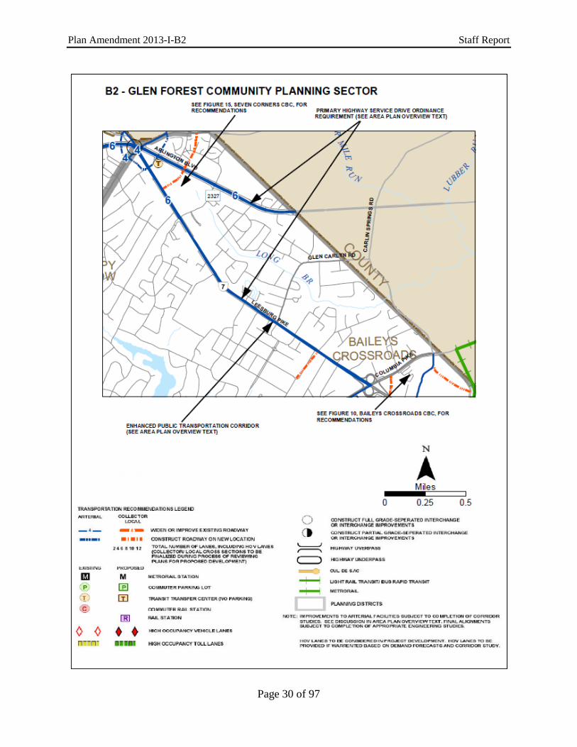
Planning District, as amended through March 3, 2015, B2-Glen Forest Community Planning Sector, Transportation Recommendations, Figure 34, page 137 with the new figure on page 30 of this Staff Report.
Page 25 of 97

Plan Amendment 2013-I-B2 Staff Report
REPLACE: Fairfax County Comprehensive Plan, 2013 Edition, Area I Volume, Baileys Planning District, as amended through March 3, 2015, B5-Barcroft Community Planning Sector, Transportation Recommendations, Figure 49, page 163 with the new figure on page 31 of this Staff Report.
MODIFY: Fairfax County Comprehensive Plan, 2013 Edition, Area I Volume, Jefferson
Planning District, as amended through October 28, 2014, Overview, page 1, as follows:
“A portion of the Seven Corners Community Business Center (CBC) is also
within the Planning District and is generally located near Hillwood Avenue, Arlington Boulevard and Sleepy Hollow Road. The Seven Corners CBC Community Business Centers includes retail, office, cultural and residential uses. The vision includes the development of high-quality, mix of in a community-scale, pedestrian-oriented setting uses. A portion of the district is part of the Seven Corners Community Business Center.”
REPLACE: Fairfax County Comprehensive Plan, 2013 Edition, Area I Volume, Jefferson
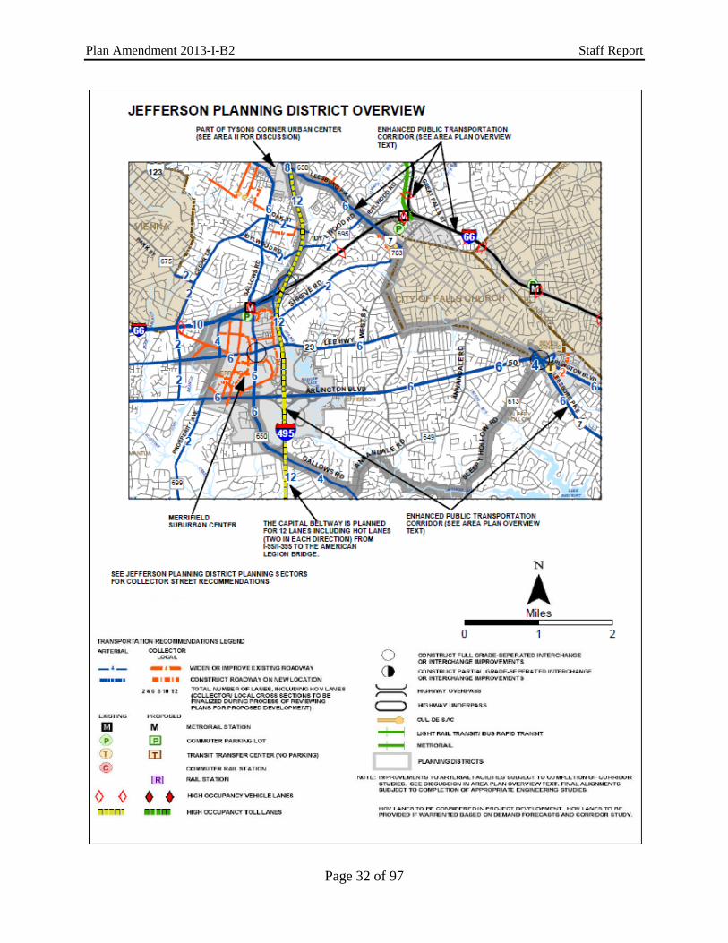
Planning District, as amended through October 28, 2014, Overview, Countywide Transportation Recommendations, Jefferson Planning District Figure 2, page 4 with the new figure on page 32 of this Staff Report.
MODIFY FIGURE: Fairfax County Comprehensive Plan, 2013 Edition, Area I Volume, Jefferson
Planning District, as amended through October 28, 2014, Overview, Figure 6, “Jefferson Planning District, Existing Public Facilities,” page 12: Modify the below sectors as follows:
“FIGURE 6 JEFFERSON PLANNING DISTRICT
EXISTING PUBLIC FACILITIES
Schools
Libraries
Public Safety
Human Services
Public Utilities
Other Public Facilities
J8 Timber Lane, Shrevewood Elem.
Va. Power Idylwood Substation, City of Falls ChurchFairfax Water Storage Tanks
J10 Marshall High East County Juvenile Court Probation Services
Health Dept. Falls Church District Office
City of Falls Church Fairfax Water Storage Tanks”
REPLACE: Fairfax County Comprehensive Plan, 2013 Edition, Area I Volume, Jefferson
Planning District, as amended through October 28, 2014, J1-Hillwood Community Planning Sector, Transportation Recommendations, Figure 10, page 20 with the new figure on page 33 of this Staff Report.
Page 26 of 97

Plan Amendment 2013-I-B2 Staff Report
REPLACE: Fairfax County Comprehensive Plan, 2013 Edition, Area I Volume, Jefferson
Planning District, as amended through October 28, 2014, J2-Sleepy Hollow Community Planning Sector, Transportation Recommendations, Figure 13, page 27 with the new figure on page 34 of this Staff Report.
NOTE: The Comprehensive Plan Map will be modified to reflect the new Baileys Upper
Elementary School on Leesburg Pike in the Seven Corners Community Business Center as a public facilities use on Tax Map Parcel 51-3 ((1)) 31.
Page 27 of 97

Plan Amendment 2013-I-B2 Staff Report
Page 28 of 97

Plan Amendment 2013-I-B2 Staff Report
Page 29 of 97
Plan Amendment 2013-I-B2 Staff Report
Page 30 of 97

Plan Amendment 2013-I-B2 Staff Report
Page 31 of 97
Plan Amendment 2013-I-B2 Staff Report
Page 32 of 97

Plan Amendment 2013-I-B2 Staff Report
Page 33 of 97

Plan Amendment 2013-I-B2 Staff Report
Page 34 of 97

Plan Amendment 2013-I-B2 Staff Report
REPLACE: Fairfax County Comprehensive Plan, 2013 Edition, Area I Volume, Baileys Planning District, as amended through March 3, 2015, Seven Corners Community Business Center, pages 108-127 as follows:
“SEVEN CORNERS COMMUNITY BUSINESS CENTER
LOCATION AND CHARACTER
The Seven Corners Community Business Center (CBC) is a gateway to Fairfax County from both Arlington County and the city of Falls Church. The CBC (see Figure 23) is centered on the intersection of three regional commuter routes: Arlington Boulevard (Route 50), Leesburg Pike (Route 7), and Wilson Boulevard/Sleepy Hollow Road. The convergence of these major routes forms the multi-cornered interchange from which the CBC derives its name. The Seven Corners CBC is a vibrant and culturally diverse community that includes approximately 218 acres. Although dominated by the Seven Corners Shopping Center, Willston I and Willston II Shopping Centers, and The Corner at Seven Corners, the CBC also contains two high rise office towers, lower scale office buildings and a variety of residential uses including garden style complexes and townhouse neighborhoods. Surrounding the CBC are stable residential communities with a variety of densities, and a number of retail, automobile sales and service, and office uses located in the City of Falls Church which, with Arlington County, forms the northern and eastern boundaries of the CBC.
The Seven Corners Shopping Center is a dominant focal point of the area and is considered both locally and regionally as the “center” of the Seven Corners CBC. The automobile orientation of this landmark, the complicated Seven Corners interchange itself, and the concentration of other highway-oriented, commercial development pose significant challenges to creating a strong sense of place.
Figure 23 – Seven Corners CBC Locator Map
Page 35 of 97

Plan Amendment 2013-I-B2 Staff Report
DEVELOPMENT AND PLANNING HISTORY
Known as Lee Boulevard in the 1920s, what is now Arlington Boulevard follows an early county road that ran from the Fairfax Court House via Falls Church and the Aqueduct Bridge to Washington, D.C. By the 1930s, it became a major commuter route with the expansion of the federal government during the Great Depression and the development of new, inexpensive housing in Fairfax County. Leesburg Pike is much older and followed wagon trails that stretched from the Shenandoah Valley via Leesburg to the port of Alexandria. It was known as the “Middle Turnpike” when it was improved between 1818 and 1838. Fort Buffalo, one of the major hill-top defensive works built by Union engineers during the Civil War to protect approaches to Washington, was located at the intersection of these two roads. The site was strategically chosen as one of several points of higher elevation along the ridge between Baileys Crossroads and the present Seven Corners.
After the Civil War, the area grew slowly with farms, scattered houses and crossroad
stores dominating the land use pattern through the early 20th Century. After World War II, the area experienced rapid residential and commercial growth as demand for new housing, and the retail and office related uses to serve it, spread from Arlington west to rural Fairfax County. In the early 1950s, the tract of land once belonging to Frederick Foote, a free black who had purchased the land in 1864, became the site of the Seven Corners Shopping Center. This was the second and at the time largest “modern” shopping center in the Washington region. This shopping center, and the grade-separated interchange built in the 1960s, set the development pattern for the area as additional commercial development occurred from that time through the 1970s, with expansions and renovations of existing facilities during the 1980s through the 1990s.
Recognizing the age of many structures in older commercial areas throughout the county,
and the opportunities and constraints of commercial revitalization and redevelopment in these areas, the Fairfax County Board of Supervisors initiated a commercial revitalization program in 1986 designating the Seven Corners area as part of a revitalization area. This designation was intended to support and encourage a comprehensive program of economic revitalization, preserve community- and neighborhood-serving retail uses, and protect stable residential neighborhoods from commercial encroachment associated with redevelopment. The primary focus in 1986 was to provide incentives for business and property owners to upgrade the area by enhancing the attractiveness of its retail establishments, continuing its neighborhood- and community-serving function, and focusing on certain “Opportunity Areas,” specifically within the Seven Corners business area.
The concept of Community Business Centers, such as the Seven Corners CBC, and
providing more focused redevelopment and revitalization guidance was introduced in the county’s 1990 Policy Plan volume of the Comprehensive Plan. To further support the revitalization process, a consultant’s study of the potential for revitalization of the Seven Corners CBC was undertaken in 1997 (Commercial Redevelopment Plan: Baileys Crossroads and the Seven Corners Revitalization Areas, Hunter Interests, Inc., Annapolis, Maryland, 1997). This study included market analyses as well as urban design, transportation, and redevelopment recommendations for the Board-designated Baileys Crossroads/Seven Corners Revitalization Area which includes the Seven Corners CBC. The consultant’s findings and recommendations were prepared at the direction of the county’s Department of Housing and Community Development (HCD), and developed with input from a citizen focus group appointed by the Mason District Supervisor to represent area residents, civic associations, the business community, and local property owners.
In 1998, the Board designated the Seven Corners CBC as a special study area for the
purpose of considering changes to the Comprehensive Plan. This enabled a later amendment of the Plan to encourage and support community revitalization efforts. This special study evaluated
Page 36 of 97

Plan Amendment 2013-I-B2 Staff Report
previous efforts and projected the development potential for the Seven Corners CBC based on an analysis of future planned infrastructure and environmental constraints. Also in 1998, the Board designated the area comprising the Seven Corners CBC as part of the Baileys Crossroads/Seven Corners Commercial Revitalization District (CRD). This designation is a special category within the county’s Zoning Ordinance intended to encourage revitalization activities by providing greater flexibility in ordinance requirements.
At the request of the Mason District Supervisor in 2012, a series of community-wide
meetings and workshops were held to begin to define a community vision for the future Seven Corners CBC as well as understand concerns, interests and goals. Following the visioning workshops, a task force and two working groups were established with a focus on land use and transportation; connectivity and transportation issues; and quality of life concerns. Participants included local residents, property and business owners, and community and civic organizations. To incorporate the recommendations of the task force for encouraging the revitalization of the Seven Corners CBC, the Board authorized a Plan Amendment in 2013. Based on the community’s vision, Comprehensive Plan guidance directs redevelopment in certain areas (Opportunity Areas) of the CBC by providing greater flexibility in uses and ways to achieve development potential. Within the Opportunity Areas, intensity of development is described through a combination of building height, building form and other urban design considerations instead of specific Floor Area Ratio (FARs). Streetscape and improved pedestrian, bicycle and vehicular connectivity guidance is provided for the entire CBC. In addition, a redesign of the Seven Corners interchange and surrounding roadway network is recommended. The following guidance reflects a new community vision and incorporates a more flexible, form-based planning approach to encourage redevelopment.
PLANNING DISTRICTS AND SECTORS
Figure 24 – Seven Corners CBC Underlying Planning Districts and Community Planning Sectors Map
Page 37 of 97

Plan Amendment 2013-I-B2 Staff Report
The Comprehensive Plan is organized by Planning Districts and Community Planning Sectors. The accompanying Planning Districts and Community Planning Sectors Map, as shown in Figure 24, indicates the relationship of the Seven Corners CBC to these districts and sectors. Consult the District Overview for additional guidance on transportation, housing, environment, heritage resources, public facilities, and parks and recreation. CONCEPT FOR FUTURE DEVELOPMENT The Comprehensive Plan for the Seven Corners CBC encourages redevelopment that will increase the residential population as well as the number and variety of jobs, while encouraging a high-quality, pedestrian-oriented environment. The plan promotes a vibrant mix of land uses to enhance the quality of life for residents, while enabling business to prosper and actively contribute to the economic and social vitality of Seven Corners. The concept envisions a variety of housing types, employment options including incubator space for entrepreneurial ventures, and shopping and entertainment within walking distance of area residents. Strategically located public open spaces are planned throughout the mixed use areas as centerpieces that foster community interaction and civic events. In addition to economic diversity, higher-density, mixed-use development will support a walkable environment and establish a sense of place. By encouraging the highest quality development, the full potential of the area can be attained while protecting and strengthening the residential communities that surround the CBC. People in nearby residential areas will have attractive walking access to the CBC where their retail and entertainment needs can be satisfied, and their lives enriched by local community activities. As stated previously, in the summer of 2012, area residents and businesses of the Seven Corners community came together to create a vision for the future CBC. This interaction and dialogue informed the work of the Seven Corners Task Force, which resulted in the overarching themes and guiding principles summarized below: Enhance the connectivity of the area via an improved and expanded street network, new bridge connection(s), better pedestrian and bicycle facilities as well as increased transit service;
Provide a range of housing options for all needs, abilities, ages and income levels, and preserve the existing affordable and workforce housing; Protect the surrounding established neighborhoods from further retail encroachment and traffic;
Create or retain compatible transitions at the edges to stable residential neighborhoods through a combination of use, intensity, scale, setbacks, and building type and height; Revitalize the Seven Corners CBC by retaining or redeveloping as part of mixed-use development a mixture of neighborhood-serving retail, office, civic, and recreational/cultural uses with a broad range of housing types to serve a diverse community;
Create spaces that foster civic interaction and community gathering, and that incorporate public art; Emphasize pedestrian scale, character, enhanced appearance and accessibility to strengthen the quality of life for residents;
Design developments to reduce reliance on single-occupant vehicles and provide only the minimum of parking necessary in mixed-use developments;
Page 38 of 97

Plan Amendment 2013-I-B2 Staff Report
Foster high-quality design and sustainable development that limits adverse impacts on the environment and the community;
Create a thriving, safe, clean and dynamic urban mixed-use center that provides essential lifestyle services, amenities, and connectivity, and embraces Seven Corners’ diverse community and central location as a transportation hub and historic gateway to Fairfax County. Planning objectives for achieving this vision include: Objective 1: Promote attractive, high-quality development that exhibits the best in design and
contributes to the overall vision of Seven Corners as a premiere place to live, work, and play.
Objective 2: Employ measures such as trails, sidewalks, and complete streets to improve
connectivity within the Seven Corners CBC and from the CBC to other areas. Objective 3: Apply streetscape design to the reconstruction and addition of all roads in the
Seven Corners CBC to achieve a system of interconnected complete streets to serve motorists, pedestrians, cyclists and transit users.
Objective 4: Promote new residential development within the Seven Corners CBC within
planned mixed use settings. Objective 5: Retain and enhance businesses serving the community. Objective 6: Ensure the pattern of land uses protects the stability of neighboring residential
areas by establishing transitional areas and preventing commercial encroachment into such areas.
Objective 7: Encourage mixed-use development, where appropriate, and pedestrian-oriented
“destination type uses,” including restaurants and small scale retailers to promote pedestrian movement and facilitate human interaction.
Objective 8: Utilize design guidelines in revitalization and redevelopment within the Seven
Corners CBC to create a more attractive and functionally efficient community-serving commercial and mixed-use area.
Objective 9: Establish civic gathering spaces, green spaces, and other public amenities such as
a community center, cultural center, public parks, and transit facility which will contribute to a sense of place in the Seven Corners CBC where the diverse communities represented by Seven Corners residents, businesses, and property owners can interact.
Objective 10: Incorporate planned roadway improvements which reflect context sensitive design
principles and include elements of complete streets. Objective 11: Create focal points using the planned new street grid and parks plan. Objective 12: Establish a hierarchy of green/civic spaces connected by a pedestrian oriented
network.
Page 39 of 97

Plan Amendment 2013-I-B2 Staff Report
AREAWIDE RECOMMENDATIONS The areawide recommendations are intended to help achieve the future vision for Seven Corners. These recommendations present overall concepts as a framework for the specific land unit recommendations that follow, and provide guidance on areawide issues that may not be specifically addressed in the land unit text because they apply to all land units. The vision of the Seven Corners CBC creates three distinct planning areas: Opportunity Areas, the Transitional Areas and the Minimal Change Area (Figure 43). Within the Opportunity Areas, where redevelopment is envisioned, a form-based approach that emphasizes scale, appearance and function is used to guide redevelopment. In the Transitional Areas, which are expected to maintain existing uses or experience only moderate change, and for the Minimal Change Area, where existing uses are expected to be retained, a more traditional, FAR intensity-based planning approach is recommended. Both such areas may only develop under the Base Development Option. However, if consistent with the overall goals of Seven Corners, parcels in Transitional Areas may be considered for additional intensity through a concurrent Comprehensive Plan amendment and rezoning application. The amendment would re-designate a Transitional Area as an Opportunity Area to allow for the use of the general Redevelopment Option guidance in the newly designated area. All applicable conditions of the Redevelopment Option should be met in the rezoning. Uses in Minimal Change Areas are envisioned to remain as presently developed for the longer term. Character and Overall Concept The ultimate goal for the Seven Corners CBC is to create a cohesive whole of its many neighborhoods and commercial centers. The sub-areas are separated by two major roadways, Arlington Boulevard and Leesburg Pike, which, without a proper north-to-south vehicular and pedestrian connection, act as barriers to the integration of the CBC. The Plan envisions three densely developed Opportunity Areas, each with a different character, to serve the greater Seven Corners area. The three Opportunity Areas will be linked together via a new “spine road” that traverses the CBC from Wilson Boulevard over Arlington Boulevard to Leesburg Pike. This spine road will act as the central organizing construct for redevelopment in the Opportunity Areas. It will serve as the major pedestrian and vehicular north-south connector road and is intended to be faced with street-activating uses and attractive building frontages. A central civic space will be located along one side of the spine road and other urban park spaces will link to it in order to create a pedestrian-accessible open space network. The spine road, together with a new grid of streets that will accompany the redevelopment of the Opportunity Areas, is planned to provide new options for navigating Seven Corners, as shown in Figure 25.
A high-quality transportation network that connects neighborhoods will form a framework for a more urban environment that can be realized through mixed-use buildings located closer to the street; ground-floor retail or other uses activating key streets; an increase in residences; and walkable, tree-lined blocks laced with several types of parks and civic spaces. Such a network will provide new connections that will link the surrounding existing uses. Planned density will step back in height to lower-scale multifamily residential or townhouse development to create a compatible transition to the surrounding residential community.
Leesburg Pike is envisioned as a multimodal transit boulevard that will accommodate high capacity transit in a dedicated space within the right-of-way through the Seven Corners CBC. It will function as an urban link to both the neighborhoods to the north, in the City of Falls Church, and to the neighborhoods to the south, towards Baileys Crossroads. As a major transportation corridor, the challenge posed by Leesburg Pike is transforming it into a pedestrian-friendly environment. To achieve this, Leesburg Pike is planned to be lined with shops, residential and office buildings oriented to the street; have wide landscaped sidewalks; be accessible; have attractive bus/transit shelters. Depending on the location of transit either in the
Page 40 of 97

Plan Amendment 2013-I-B2 Staff Report
center or edge of the road, Leesburg Pike may include a landscaped median that also serves as a refuge for pedestrian crossings. Denser developments will be concentrated along both sides of Leesburg Pike, with taller buildings along the Seven Corners Shopping Center side of the road. Crucial pedestrian and bicycle crossings are addressed in further detail in the Transportation section.
Arlington Boulevard, from Patrick Henry Drive to Cherry Street, is intended to serve as the major through corridor for vehicular traffic. It should also accommodate pedestrians and bicyclists by providing a safe and separated facility for users. Development along this corridor within Seven Corners should be more inward focused to direct pedestrian activity along Leesburg Pike as well as the spine road and the village main street.
Figure 25 – Opportunity Areas Concept Map
Planning Approach for the Opportunity Areas Emphasizing Form Instead of Floor Area Ratio (FAR)
The plan uses a form-based approach to incentivize redevelopment in the Opportunity Areas by emphasizing the scale, land use relationships, urban design principles and function of future development while providing flexibility with respect to specific land uses and intensities. Specifically, building form, design, and height guidance is provided in the plan to describe the development potential of properties within the Opportunity Areas in lieu of more traditional FAR limitations. As such, the amount of building areas allocated to any given property or assemblage will be prescribed by building height, the allotted total square footage for a sub-unit, urban design guidance, parking requirements, street connections and other criteria which may further affect the buildable area. This approach recognizes that intensity expressed as FAR is not always
Seven Corners Community Business Center (CBC)
Opportunity Areas Concept Map
Page 41 of 97

Plan Amendment 2013-I-B2 Staff Report
the best indicator of good urban design, building form or project viability. With this form-based approach, developers will have the flexibility to design a project which meets their needs, while conforming to the vision of the community. While the plan aims to maintain and enhance a variety of uses, some flexibility may be appropriate when determining the amount and type of specific nonresidential uses for each site in order to achieve plan objectives so long as the total square footage for the sub-unit is not exceeded and the overall intent for the variety of uses in the sub-unit is preserved (refer to Sub-units Map, Figure 43). The form-based approach utilizes a maximum total development potential which applies to each individual sub-unit within the Opportunity Areas in the Seven Corners CBC. Capacity for any individual development will be dependent on satisfaction of criteria outlined within the Comprehensive Plan that support the best quality redevelopment of these areas. The total available development potential of the Opportunity Areas combined is approximately 7.6 million square feet (sf), with an allocation of square footage among the different sub-units and land uses as indicated in Figure 26. As a result, the approximate overall total build-out for the entire CBC is 10.3 million square feet.
Figure 26 – Opportunity Areas Redevelopment Option Table
The redevelopment potential of the Opportunity Areas within the Seven Corners CBC
can be achieved using the form-based approach to inform the general type, intensity, and distribution of development. The form-based approach is comprised of four major components:
1. Maximum Building Heights 2. General Land Use 3. Urban Street Design 4. Urban Design Recommendations
These four components, along with Policy Plan guidance, will be used to implement the
vision of the Seven Corners CBC. The intent is to provide a simple, easy-to-understand method for determining options, as well as for flexibility in implementation. The Maximum Building Heights Map (Figure 27) illustrates the recommended maximum building height within the
Page 42 of 97

Plan Amendment 2013-I-B2 Staff Report
Opportunity Areas. General land use guidelines, as well as detailed sub-unit guidance, describe the recommended uses, and include specific conditions to be addressed. The Urban Street Network describes desired street design and pedestrian realm improvements. Finally, Urban Design Recommendations provide guidance regarding building siting, design and form, as well as approaches for addressing the building zone area.
Building heights are highest within the Opportunity Areas, and generally taper down to
the adjacent communities within and adjacent to the CBC. The tallest buildings are recommended to be located along or near Wilson Boulevard, Arlington Boulevard, and Leesburg Pike, as the larger right-of-way widths can best accommodate the planned height. The additional height will help create focal points that emphasize the core areas of Seven Corners. Further, the tallest buildings and most intense development should be located closest to transit opportunities. Those portions of the Opportunity Areas that border lower scale residential uses should transition to lower heights consistent with the Maximum Building Heights Map to address impacts of scale on adjacent residential areas.
Figure 27 – Maximum Building Heights Map
Opportunity Areas
Each Opportunity Area is intended to function as an activity node, with a distinct character, but should be designed to function as part of a larger whole through linkages to one another and through a network of public open spaces. The individual character of each Opportunity Area will be defined through its respective uses, building type and height, level of development intensity, open spaces, architectural design and streetscapes. The three Opportunity
Page 43 of 97

Plan Amendment 2013-I-B2 Staff Report
Areas are the Town Center, the Willston Village Center and the Leesburg Pike Village as depicted in Figure 28 and described in greater detail next.
Figure 28 – Framework Plan Map
Willston Village Center
Currently the site of the Willston Multicultural Center, surface parking, the Willston I Shopping Center, the Seven Corners Apartments and the East Falls Church Apartments, this Opportunity Area is envisioned to be more neighborhood-serving and smaller in scale than the Town Center. This area is planned to be organized around a village main street where ground-floor retail, an urban plaza, outdoor dining areas, and community uses will be concentrated to create a lively, pedestrian-friendly environment… Willston Text Option A: Office use may be developed as a new East County Center that would provide human services to the local community. Residential uses, office space and a community-serving recreational/cultural space should be located in the upper floors… Willston Text Option B: The Willston Multicultural Center may be redeveloped as office or a public facility use such as an educational, cultural, governmental and/or human services use to support the local community… …Architecture should provide varied rooflines, use of balconies and bays and articulated building facades, and reflect a residential character. Distinctive architectural treatment of
Seven Corners Community Business Center (CBC) Framework Plan
Page 44 of 97

Plan Amendment 2013-I-B2 Staff Report
ground-floor uses should distinguish the different uses. The village main street is planned to connect the spine road to Patrick Henry Drive to create an important vehicular link and provide a continuously activated pedestrian space that serves as a focal point for the village. The neighborhood surrounding the main street should consist of medium to higher density residential development in buildings that frame the streets. Heights should transition to be compatible with existing, nearby residential development and be consistent with the Maximum Building Heights Map (Figure 27). Additional pocket parks should be provided in this area along with an athletic field that is separate from, but connected to, the existing Upton Hill Regional Park. Town Center
Currently, the Town Center Opportunity Area is the site of the Seven Corners Shopping Center. It is envisioned to have the highest intensity of development and the tallest buildings. Mixed-use development consisting of residential, retail, office and hotel uses is planned to be organized around a large, central plaza that will serve as the main public gathering place for the greater Seven Corners community. This civic place will be where large community events can be held and will be further activated by retail and cultural uses. This plaza should be located along or connect with the spine road, which will allow convenient access to the plaza from areas to the north and south of the town center. Residential uses above or horizontally mixed on the site are intended to create a place where people can live and work and minimize their dependence on the automobile. The site will continue to be the location for the Seven Corners Transit Center, which may be relocated in conjunction with the future implementation of enhanced transit along Leesburg Pike. Architecture is envisioned to be modern with step-backs and building articulation to create a pedestrian environment at the street level. Flat rooflines that incorporate interesting towers or spires and with varied building heights throughout the area would create visual interest. Development along Leesburg Pike should be outward facing so as to enliven this corridor, have street-level retail or other active uses and, generally, be in keeping with the transit boulevard character of Leesburg Pike. Leesburg Pike Village
The Leesburg Pike Village, also known as Land Unit C, encompasses the parcels west of Leesburg Pike, south of Baileys Upper Elementary School, north of Patrick Henry Drive, and abuts the stable residential neighborhoods of Ravenwood, Ravenwood Park and Sleepy Hollow Manor. It is currently the site of a stand-alone retail department store, two office buildings and a large parking deck. This Opportunity Area is envisioned to be a mixed-use village that provides higher building heights along Leesburg Pike with buildings along the residential periphery of the site limited to townhouses that are up to three stories in height. Appropriate transitions in building form, materials and type should be used to transition to and preserve the character of the existing neighborhoods. Appropriate buffering and screening should be provided between this land unit and the adjacent residential neighborhoods, including the Shadeland Drive cul-du-sac in order to visually screen the new uses from the existing uses. A new internal road system north of Juniper Lane is planned to intersect to the spine road at Leesburg Pike. No vehicular or pedestrian connections are envisioned to Shadeland Drive. Vehicular ingress and egress for trips generated by the uses located on the parcels north of Juniper Lane should be directed to and from Leesburg Pike. For parcels south of Juniper Lane, access should be to Juniper Lane and not to Patrick Henry Drive. Neighborhood-serving retail uses, office uses, and multifamily uses should be integrated together to create the village center. Amenities such as publically accessible park spaces providing active and passive recreation opportunities as well as cafes, outdoor seating areas, gathering and entertainment spaces should be oriented to new streets connecting to Leesburg Pike. Development along Leesburg Pike should complement redevelopment at the Town Center, including the provision of street-level retail/office to reinforce the transit boulevard character that is envisioned. Interparcel vehicular and pedestrian connections should
Page 45 of 97

Plan Amendment 2013-I-B2 Staff Report
be made to the adjacent elementary school. A public park space should be located adjacent to the elementary school. Development Options for Opportunity Areas Base Development Option:
The base development level reflects existing and zoned intensities and uses. The areawide recommendations for Urban Design, Transportation, Public Parks, and other guidance are generally applicable to the base development option. Redevelopment Option:
The redevelopment option provides an increase in the development potential of certain areas in exchange for certain uses, facilities, or other elements which are deemed appropriate to implement the vision for Seven Corners. A variety of benefits have been deemed appropriate to be considered for additional development potential, including, but not limited to:
1. Coordinated Development and Phasing – Development and redevelopment is expected to occur over time and be phased. It is important particularly when there is more than one owner of a sub-unit to coordinate development plans and phasing so that current and future phases work cohesively and implement a coordinated concept plan.
2. Contribute to the Transportation Network – Enhancements should be made to improve the pedestrian, bicycle and vehicular circulation on existing and planned roadways.
3. Conformance with Urban Design and Urban Street Guidance – Redevelopment should conform to the guidance provided in the urban design recommendations and guidelines to achieve the desired building form, type and placement of buildings, and specified streetscapes. All redevelopment should demonstrate how it will contribute to the defined character of the area.
4. Public Parks – Parks and recreation areas or contributions that exceed county urban parks framework recommendations may also be considered. These spaces are expected to be provided with the initial phase of redevelopment.
5. Public Facilities – Monetary contributions or land should be provided for identified public facilities that are needed to accommodate the future development of the Seven Corners CBC. Such facilities may include, but are not limited to a school, government center, cultural center, community center and/or transit facility.
6. Provide Enhanced Green Building Certification – LEED certification, or the equivalent, is the minimum expectation for the Seven Corners CBC, as established by county policy.
7. Compatibility with Adjacent Land Uses to Include:
a. Tapering of building height and buffering as needed to provide a transition to lower density neighborhoods, and/or
b. Physical connection and complementary architectural style when adjacent to higher intensity uses.
8. Provide a Significant Affordable Housing Component – A key to the continued growth of
Seven Corners is the availability of a variety of housing types at a range of income levels.
Page 46 of 97

Plan Amendment 2013-I-B2 Staff Report
The Policy Plan states that affordable housing should be located close to employment opportunities and should be a vital element in high density and mixed-use development projects. As a center for jobs and commerce, Seven Corners is well situated to provide housing which will promote a vibrant CBC.
Figure 29 – Affordable Housing Table
In Sub-units A-1 and A-2, a 1:1 replacement of affordable residential units within the development area is expected. Projects with a residential component in Sub-unit A-3 and Land Unit B may be granted redevelopment potential if 15 percent of the residential units in new developments are affordable to households with incomes ranging up to 120 percent Area Median Income (AMI). In Land Unit C, projects with a residential component may be granted redevelopment potential if 12 percent of the residential units in new developments are affordable to households with incomes ranging up to 100 percent AMI as per county policy. All affordable units should fall within the income tiers shown in Figure 29. The Redevelopment Option includes the Policy Plan density bonus and is not intended that there be an additional bonus for the provision of affordable and/or workforce units.
Planning Approach for the Transitional Areas/Minimal Change Area The areas of the Seven Corners CBC outside of the Opportunity Areas are referred to as either Transitional Areas or as Minimal Change Areas. Land uses and development patterns in these areas, which include, for example, the twin office towers, the Willston II Shopping Center, the Corner at Seven Corners, and the Hollybrooke Condominiums, represent stable residential areas and commercial areas not planned for redevelopment. The Transitional Areas represent a variety of uses that, given recent or continued reinvestment, location or overall community value, are planned to be retained. Nevertheless, parcels within Transitional Areas may be appropriate for consideration of redevelopment through a concurrent Comprehensive Plan amendment and rezoning application. This approach is consistent with county policy to facilitate redevelopment in designated revitalization districts and areas. Proposals for redevelopment pursued under this option should demonstrate the ability to provide the benefits recommended for consideration under the redevelopment option in the Opportunity Areas. The concurrent Comprehensive Plan amendment and rezoning process will explore additional benefits necessitated as a result of redevelopment within the Transitional Areas.
The Plan uses a more traditional, FAR intensity-based planning approach in the Transitional Areas. New development or redevelopment could occur using the Base Development Option and consistent with sub-unit guidance. However, if consistent with the overall goals of the Seven Corners CBC, parcels in Transitional Areas would be re-designated as an Opportunity Area so as to allow for the use of the Redevelopment Option in the newly
Up to 70% of AMI 3% of total unitsUp to 60% of AMI 2% of total units
n/a2% of total units5% of total units3% of total units2% of total units
Up to 120% of AMI 2% of total unitsUp to 100% of AMI 3% of total unitsUp to 80% of AMI 5% of total units
15% Tier 12% TierIncome Tiers
Affordable Housing
Page 47 of 97

Plan Amendment 2013-I-B2 Staff Report
designated area. All applicable conditions of the Redevelopment Option should be met in the rezoning.
Parcels within the Minimal Change Area are not anticipated to redevelop and are envisioned to retain current uses and intensities. However, this area also has a base development option. GENERAL LAND USE GUIDELINES General and specific guidance is provided to implement the vision of the Seven Corners CBC. The following guidelines are intended to supplement the land unit recommendations. Land Use A mixture of uses should be provided in the Seven Corners CBC such that a vibrant, unique, and social place is created that extends activity beyond the normal working hours. The success of this vision is reliant on providing a broad range of dwellings, uses, and services that respond to the needs of the local residents, employees, and regional users. The coordinated design of the Opportunity Areas within the CBC will provide new environments connected by open space, walkways, trails and roadways. These areas combined with an improved transportation network will promote competiveness of individual uses and the CBC as a whole. Supported Uses In general, mixed-use development is planned for the Opportunity Areas, as expressed in the land unit recommendations, where residential, commercial, office, hospitality, civic, institutional and retail uses or a mixture of those uses are expected within the Seven Corners CBC. Arts and cultural uses are supported in specified areas within the CBC to serve the community and to complement surrounding uses. Discouraged Uses Uses that detract from the planned vision of the CBC should be discouraged. These include, but are not limited to:
- Storage and Distribution – Storage or distribution as primary use is discouraged. These uses detract from the vision of a vibrant, urban community. If these kinds of uses are considered, they should be incorporated into a mixed-use development. For example, a self-storage facility which includes office and retail facing the street would be preferable to a warehouse without an active use component. Facilities for the storage of lumber, building materials, and similar contractor yards, should also be discouraged.
- Auto-oriented and Drive-through Uses – New auto-oriented uses are discouraged. Uses which include drive-thrus, including fast-food restaurants, and others, do not contribute to a pedestrian-friendly environment. Drop-off areas or porte-cocheres should also be discouraged as they disrupt pedestrian and vehicular traffic flow. The creation of freestanding pad sites is also discouraged.
- Outdoor Sales and Storage – Outdoor sales of equipment and material as a primary use is discouraged. This includes motor vehicle sales, trailer sales, and other equipment. This does not include limited materials typically stored indoors, but displayed outdoors for sidewalk sales or similar events. Unscreened outdoor storage of equipment or materials should be highly discouraged.
Page 48 of 97
Plan Amendment 2013-I-B2 Staff Report
Alternative Land Uses Alternative uses are those uses which may not be specifically recommended in an area, but which may be consistent with the vision of the Seven Corners CBC, and which would not have impacts which exceed those uses which otherwise would have been supported. When an alternative land use can be demonstrated to be consistent with the desired urban form and compatible with the surrounding development and when the Plan’s transportation needs, pedestrian orientation, and other urban design aspects called for in the Plan are adequately addressed, such uses may be considered. For example, a hotel use may be compatible in areas planned for office and retail use provided that such use conforms to the desired form, contributes to the pedestrian orientation, and provides needed public amenities. In addition, the Plan is flexible and encourages future opportunities for institutional, cultural, recreational, and governmental uses which enrich community life, improve the provision of public services, and enhance the area’s business competiveness. Such uses may be considered where the use and scale is compatible with planned uses. Generally, community-serving institutional uses, such as a community center, may be considered in any land unit if the use is of a similar scale and character as other uses planned for the sub-unit. Other General Guidelines
- Affordable Housing – For all base development proposals outside the Opportunity Areas with a residential component, affordable housing should be provided in accordance with the Affordable Dwelling Unit Ordinance and the Guidelines for the Provision of Workforce Housing set forth in the Policy Plan. Per the county policy, any residential use should provide at a minimum 12 percent of new units as affordable housing. The residential use should accommodate a variety of households such as families, housing for the elderly. The units should meet ADA requirements and accommodate universal design.
- Parcel Consolidation – For all development proposals, consolidation is highly encouraged as a way to achieve the planning objectives for the CBC. Parcel consolidation should be logical and of sufficient size to allow projects to function in a well-designed, efficient manner, and address transportation needs, particularly related to access management and connectivity. In general, any unconsolidated parcels should be able to redevelop in conformance with the Plan.
- Telecommunications – New buildings should be designed to accommodate telecommunications antennas and equipment cabinets on rooftops. Such design should be compatible with the building’s architecture and should conceal antennas and equipment from surrounding properties and roadways by flush mounting, screening antennas, and/or concealing related equipment behind screen walls or building features.
HERITAGE RESOURCES A comprehensive field survey of the Seven Corners CBC has not been conducted. The potential exists for significant heritage resources associated with the area’s 20th century residential and commercial history. Prior to the rezoning process, heritage resource studies should be conducted and completed to identify significant residential, commercial, public facility and recreational resources in the area. Significant historic properties should be evaluated for preservation and incorporation into any new development plans. The Seven Corners CBC contains the historically significant Willston planned community. Built in the early 1950s, Willston is one of the county’s first planned mixed use
Page 49 of 97

Plan Amendment 2013-I-B2 Staff Report
centers. It is eligible for listing in the Fairfax County Inventory of Historic Sites and may be eligible for listing in the National Register of Historic Places. The county’s Heritage Resource Management Plan, adopted by the Board of Supervisors in 1988 and referred to in the Policy Plan, provides for the registration and protection of heritage resources identified under the study unit of Suburbanization and Urban Dominance. Alternatives to wholesale demolition of the apartment complex and wholesale realignment of the streets should be considered, including redevelopment within the existing apartment buildings to preserve the current configuration. The shopping center at Tax Map Parcel 51-3((18))4 has been altered dramatically, losing its integrity and is appropriate for redevelopment. The former Willston School building at Tax Map Parcel 51-3((18))1 has been altered and is recommended for study and evaluation prior to any ground disturbing activity. For the purpose of recording and documenting historic and architectural information, the full extent of the post-World War II Willston area needs to be identified. It should be photographed and documented prior to any ground disturbing activity by an individual who meets The Secretary of Interior’s professional qualification standards. After identifying significant historic and architectural features, measured drawings and photographs should be prepared in coordination with county heritage resources staff prior to any ground disturbing activity. The Doctors Building at Tax Map Parcel 51-3((1))3A and 3B is significant for its mid-20th century modern architecture and is eligible for listing in the Fairfax County Inventory of Historic Sites. Eligibility for listing in the Inventory recognizes that a property meets criteria established by the Board of Supervisors to identify sites of importance; therefore, the goal is retention and preservation of the historic resource. Consideration should be given to using this building as an example of new architecture that may be planned, and incorporating it into any new area designs. Also within the Seven Corners CBC is one of the original sandstone markers placed in 1791 to designate the original boundary of the District of Columbia. These boundary stones are listed in the National Register. D.C. Boundary Stone G, S.W. Line #8 is located at Tax Map Parcel 51-3((18))D1. Although previously moved, the stone should be retained in its current location and be incorporated into the open space of any new development. If moving the stone is unavoidable, the move should be coordinated with the Children of the American Revolution (C.A.R.) and follow guidance developed by the National Capital Boundary Stones Committee. Any development or ground disturbance in this area, both on private and public land, should be preceded by heritage resources studies, and alternatives should be explored for the avoidance, preservation or recovery of significant heritage resources that are found. In those areas where significant heritage resources have been recorded, an effort should be made to preserve them. If preservation is not feasible, then, in accordance with countywide objectives and policies as cited in the Heritage Resources section of the Policy Plan, the threatened resource should be thoroughly recorded and in the case of archeological resources, the artifacts recovered. ENVIRONMENT Much of the natural environment of the Seven Corners CBC has been changed with development. The area contains sparse vegetation. Creation or addition of green space, planting of new trees and landscaping should be encouraged with new development and redevelopment. Future development and redevelopment of the Seven Corners CBC should promote increased quality of life for the public and improve the quality of natural resources by employing sustainability in planning and design. The Policy Plan’s Environment Section provides guidance
Page 50 of 97

Plan Amendment 2013-I-B2 Staff Report
for green building practices applicable to CBCs and includes sustainable practices such as the achievement of the U.S. Green Building Council’s Leadership in Energy Environmental Design (LEED) certification or equivalent third-party certification. Sustainable practices may include:
- Low Impact Development (LID) Stormwater Techniques – Innovative stormwater management techniques as provided in the Stormwater Management guidance.
- Site Design and Construction – Green building practices for new and renovated buildings can, but are not limited to, include the incorporation of solar orientation for heating and cooling, onsite renewable energy production, low energy lighting fixtures, green roofs, low-maintenance landscaping, and the use of recycled construction materials. Construction waste should also be recycled, when possible. Graywater should be reused on site where feasible.
- Pedestrian Oriented Design – Building layout and streetscape facilities with enhanced pedestrian accessibility to minimize automobile dependence in the Seven Corners CBC, supporting the goals described in the Urban Design Recommendations.
Water Quality The majority of this area was developed in an era when the goal of stormwater management was to move water away from developed areas as quickly as possible, with no real consideration for removing pollutants or reducing impacts to receiving streams. As a result, many surrounding streams are in poor condition. Future development offers considerable opportunities to improve upon past stormwater management practices that could protect and restore local streams and reduce pollutant loads entering the Potomac River and Chesapeake Bay. New development should reduce pollutants and manage the volume and velocity of runoff through the use of LID measures and stormwater management best management practices (BMPs). Any Resource Protection Areas (RPAs) or Environmental Quality Corridors (EQCs) should be addressed in a manner consistent with Environmental Policy Plan objectives. Stormwater Management The Seven Corners CBC is located on the drainage divide between the Cameron Run and Four Mile Run watersheds. Specifically, it is located in the upper reaches of a subwatershed associated with a tributary of Tripps Run (Cameron Run watershed) and the upper reaches of the Long Branch subwatershed (Four Mile Run). Both watersheds have long histories of urbanization, with most of the land developed before the advent of stormwater controls. Nonpoint source pollution and urban stormwater runoff greatly affect the health of these watersheds. An RPA associated with the Long Branch subwatershed is located in Sub-unit F-2. A watershed management plan was developed in 2007 for the Cameron Run watershed, and in 2011 for the Four Mile Run watershed. These plans recommend a number of spot-improvement stormwater projects within or near the CBC. Receiving waters downstream of Seven Corners should be protected by reducing runoff from impervious surfaces within the Seven Corners CBC. By using a progressive approach to stormwater management, downstream stormwater problems can be mitigated and downstream restoration efforts can be facilitated. Measures to reach this goal may include the application of LID Techniques, including but not limited to rain gardens, vegetated swales, porous pavement, vegetated roofs, tree box filters, and water reuse. The incorporation of LID practices in street rights-of-way and parking lots will also support this goal; such efforts should be pursued where
Page 51 of 97

Plan Amendment 2013-I-B2 Staff Report
allowed. There is also a potential for the establishment of coordinated stormwater controls over multiple development sites. Stormwater Design Environmentally-friendly stormwater design should be an integral design principle that is part of the conceptual stage of site development, recognizing that stormwater management measures may be phased with development. The stormwater design should first seek to minimize the effect of impervious cover, followed by the application of stormwater reuse, retention, detention, extended filtration and, where soils and infrastructure allow, infiltration to improve downstream waters. Coordination of stormwater management controls among multiple sites may also be effective in achieving stormwater management goals in an efficient manner. Stormwater management and water quality controls should be optimized for all future development projects consistent with the scale of such projects and revitalization goals. Stormwater management and water quality controls for redevelopment should be designed to return water into the ground where soils are suitable or reuse it, where allowed. Stormwater quantity and quality control measures should be provided with the goal of reducing the total runoff volume and/or significantly delaying its entry into the stream system. In furtherance of stream protection and/or restoration through replication of natural hydrologic conditions, the emphasis should be on LID techniques that evapotranspire water, filter water through vegetation and/or soil, return water into the ground or reuse it. LID techniques of stormwater management should also be incorporated into new and redesigned streets, as well as parking lots, where allowed and practicable. In addition, at a minimum the following guidelines should be followed for any application in an Opportunity Area where an intensity increase of more than 50 percent or above 1.0 FAR is proposed. Any development proposals should be reviewed on a case-by-case basis for the appropriate optimization of stormwater management and water quality controls, allowing for flexibility in specific approaches taken to achieve these guidelines.
1. For sites that have greater than 50 percent impervious cover in the existing condition, the
total volume of runoff released from the site in the post-developed or redeveloped condition for the two-year, 24-hour storm should be at least 25 percent less than the total volume of runoff released in the existing condition for the same storm. Furthermore, the peak runoff rate for the two-year, 24-hour storm in the post-developed condition should be at least 25 percent less than the existing condition peak runoff rate for the same storm.
2. For sites that have 50 percent or less impervious cover in the existing condition, the total volume of runoff released as well as the peak release rate for the one- and two-year, 24-hour storm in the post-developed condition should be equal to or less than the total runoff volume and peak release rate in the existing condition for the same storm.
3. In addition to item 1 or 2 above, stormwater runoff associated with the development should be controlled such that either: (a) the total phosphorus load for the property is no greater than what would be required for new development pursuant to Virginia’s Stormwater Regulations/ the county’s Stormwater Management Ordinance; or (b) an equivalent level of water quality control is provided.
4. As an alternative to items 1, 2 and 3 above, stormwater management measures may be provided that are sufficient to attain the Rainwater Management credit of the most current version of Leadership in Energy and Environmental Design-New Construction (LEED-NC) or LEED-CS (Core & Shell) rating system (or equivalent of this/these credit(s)).
Page 52 of 97

Plan Amendment 2013-I-B2 Staff Report
5. As an alternative to the minimum guidelines above, stormwater management measures and/or downstream improvements may be pursued to optimize site-specific stormwater management and/or stream protection/restoration efforts, consistent with the adopted watershed management plan(s) that is/are applicable to the site. Such efforts should be designed to protect downstream receiving waters by reducing stormwater runoff volumes and peak flows from existing and proposed impervious surfaces to the maximum extent practicable, consistent with watershed plan goals.
The above guidelines are intended to improve stormwater management controls
sufficiently to allow for improvements to the habitat and recreational values of streams near the Seven Corners CBC through natural restorative processes and/or through restoration projects. Air Quality
While there is very little heavy industry within Fairfax County and there is no expectation that any portion of Seven Corners would be recommended for such uses, air quality remains a concern. A high volume of vehicular trips through the area contributes to air pollution. Measures such as access to transit, limiting single passenger vehicle trips, ridesharing, mixed-use development, as well as tree preservation and encouraging the planting of new tree cover can all aid in the goal of air quality improvement. Noise The Seven Corners CBC is affected by transportation noise from Arlington Boulevard, Leesburg Pike, Wilson Boulevard and other roadways. The Policy Plan recommends against new residential development and other noise-sensitive uses in areas where current and future noise levels exceed 75 decibel (dBA) day-night loudness (DNL). However, broader planning goals for the Seven Corners CBC may suggest that sites near major roadways would be appropriate for residential development and/or other noise-sensitive uses. Where such locations are proposed, efforts should be made to design these uses in order to minimize the exposure of noise-sensitive interior spaces to noise levels above DNL 75 dBA. Where residential or other noise sensitive uses are proposed near major roadways, such proposals should only be considered with the provision of a noise study during the review of the development and appropriate commitments to noise mitigation measures. The noise study should clearly define the noise levels impacting the proposed uses as a measure of dBA DNL. The noise study should include noise contours and/or noise impacts at each façade of each affected building with current noise levels and future noise levels based on a minimum 20-year traffic volume projection for the roadway and other transportation noise sources. In addition, the noise study should identify noise levels that may affect building facades at different elevations. When a noise study indicates noise levels in excess of DNL 65 dBA on proposed noise sensitive uses, mitigation measures should be provided with the goal of achieving DNL 45 dBA for interior space and DNL 65 dBA for outdoor recreation areas. Attenuation may include siting and orientation of the noise sensitive use, as well as the use of building materials and noise barriers. Where projected noise at affected building facades exceed DNL 75 dBA, and for dwelling units where outdoor balconies are projected to have noise levels that exceed DNL 65 dBA, then disclosure statements should be provided to affected residents and users within the impacted uses or units. The disclosure statement should clearly identify the mitigated and unmitigated noise levels for interior space and noise levels for any affected balconies. Post-development noise studies should be conducted in order to help staff evaluate the effectiveness of interior noise mitigation measures.
Page 53 of 97

Plan Amendment 2013-I-B2 Staff Report
SCHOOLS Traditionally, public school capacity needs have been addressed through various means including dedication of land, new school construction, additions to existing facilities, interior architectural modifications, use of modular buildings, changes to programs, and/or changes to attendance areas. In addition to the traditional means for addressing school capacity requirements listed above, Fairfax County Public Schools should evaluate other possible “in-kind” school impact mitigation strategies such as the utilization of private buildings to accommodate civic programs, adult education classes, and governmental/quasi-governmental school related programs such as Early Head Start, Head Start, and School Age Child Care (SACC) programs. Schools Text Option A: The impact of development on schools should be mitigated by the developer(s) and the county. Any impact on public facilities (particularly schools), services and transportation, necessitated by any increased intensity, must be addressed with provisions for mitigation before work begins. Under the envisioned plan for growth there will be a need for a new elementary school, as well as capacity enhancements at the middle and high school levels. Schools Text Option B: The impact of development on schools should be mitigated by the developer(s) and the county. Any impact on schools, necessitated by any increased intensity, must be addressed with provisions for mitigation. Under the envisioned plan for growth there will be a need for a new elementary school, as well as capacity enhancements at the middle and high school levels. TRANSPORTATION Overview
Seven Corners is the junction of two major regional roads, Arlington Boulevard (Route 50) and Leesburg Pike (Route 7). Arlington Boulevard is a limited access, major arterial, highway through the Seven Corners area. Arlington Boulevard is a primary road for people driving to and from Washington D.C. who cannot use Interstate 66 (I-66) because of High Occupancy Vehicle (HOV) restrictions during the peak period in the peak direction. Leesburg Pike, another major arterial road, connects the City of Alexandria through Baileys Crossroads, the City of Falls Church, and Tysons to Loudoun County. The land uses along Leesburg Pike vary from high intensity office and retail uses to low density residential and speed limits vary from 25 miles per hour to 40 miles per hour. The segment of Leesburg Pike through Seven Corners shares urban characteristics with the other activity areas through which it travels.
The vast majority of trips to, from, within, and through Seven Corners are made using
private automobiles. Most of the vehicles traveling through the Seven Corners area are on Arlington Boulevard and Leesburg Pike, with the majority on Arlington Boulevard. Both local and through traffic currently use the same regional roads to get around or through Seven Corners. The concept for the future transportation system envisions providing more choices for those who travel through the area. This requires a balanced transportation system, which promotes all modes of travel, with attractive public transportation connections between Seven Corners and other locations. The system should also move people within Seven Corners via an enhanced connected network of walkable streets, dedicated bicycle facilities (e.g. bike lanes), and a robust transit network. Finally, the system should also move automobile traffic more efficiently to, from, within, and through Seven Corners.
Page 54 of 97

Plan Amendment 2013-I-B2 Staff Report
Implementation and Funding for Transportation Improvements A longstanding planning concept in the Comprehensive Plan is linking development to
the provision of the infrastructure needed to support it. A dynamic and evolving plan that links redevelopment with the associated public improvements is critical to ensuring the transformation of Seven Corners. Growth will need to be supported by transportation improvements that better connect Seven Corners internally and to the rest of the region. The transportation improvements are set forth in the Road Improvements section of the Plan and are based on the planned land use recommendations also set forth herein. The planned development level will occur over the course of time. Planning for and sequencing transportation infrastructure will need to take into account actual and projected growth for different land uses based on the development pipeline as well as mid and long range market forecasts. In addition, major transportation improvements can take many years to design, fund, and construct. Therefore, the sequencing of such public improvements will require close monitoring of approved rezonings, building permits, commuting patterns, demographic trends, and population and employment growth.
All development proposals should perform a traffic impact analysis and the mitigation
measures identified by this analysis should be considered in the context of the entitlement process. In addition, the county should conduct an analysis of new development and infrastructure projects at such time as a combination of 1,900 dwelling units and 4.2 million square feet of nonresidential development exists within the CBC. Such analyses should assess how the pace of growth compares to the provision of transportation infrastructure projects; and, whether total development approved through rezonings is in balance with the private and public sector commitments toward achieving the necessary transportation improvements.
While some transportation improvements are not dependent on redevelopment and will
move forward through publicly lead efforts, others will be implemented through the redevelopment process as that occurs over time. Transportation improvements should be appropriately phased with development, and development proposals should only be approved following additional transportation analysis and the provision of appropriate transportation mitigation measures, including shorter term spot improvements.
Funding these transportation improvements through federal, state, regional and county
sources should be pursued; however, some combination of public and private sector funding will be necessary to cover the costs associated with these improvements and to expedite implementation. Additionally, these improvements may be implemented in stages by the private sector as development occurs. The intent is to facilitate and time transportation improvements that can be in place to support new development and address existing transportation issues. Further detailed examination of these funding options for each improvement identified and those that have not been identified is needed before a preferred funding approach is selected.
In order to better serve existing and future users, a fundamental transformation of the Seven Corners transportation system is required. Several transportation elements must be created and/or enhanced as follows:
- For trips within the Seven Corners area and surrounding neighbors, circulator bus routes,
with connections to the East Falls Church Metrorail Station and the Seven Corners Transit Center, that allow frequent, quick, and inexpensive movement are needed. With easier implementation than roadway improvements, a circulator service could be provided in the nearer term to address existing congestion issues as well as those generated by new development.
Page 55 of 97

Plan Amendment 2013-I-B2 Staff Report
- The current street network should be transformed into a system of smaller, connected streets to provide alternative pathways for pedestrians, bicyclists, transit users, and automobiles.
- Streets should become “complete streets,” which means they will promote and accommodate multiple modes of transportation such as bike lanes or adequate sidewalk width. The streets should be designed to create a sense of place, promote walking and help influence a more urban development pattern.
- The transit system should provide superior service to and from the East Falls Church Metrorail Station. In addition, buses should provide opportunities to travel to, from, and within Seven Corners.
- Enhancements to the road network, such as expanded street connections, a simplified
Seven Corners interchange with improved crossings over and to Arlington Boulevard, and state of the art traffic management systems.
Land Use/Transportation Balance
In order to maintain a balance between land use and transportation, as well as create a healthier, more sustainable environment, alternatives to automobile travel will become increasingly important and should meet increasingly higher targets over time. This can be achieved by successfully implementing the following strategies:
- The provision of necessary transportation infrastructure for multiple modes, such as bike facilities, sidewalks, and transit amenities and services.
- The achievement of higher vehicle trip reduction levels over time through transportation demand management (TDM) programs including an increase in carpooling, telework, the application of variable working hours, and reducing the ratio of parking spaces to floor area.
- The encouragement of mixed-use development to increase walking trips. - Development should be coordinated with the commensurate provision of transportation
infrastructure and specific programs to reduce vehicle trips. - Maintaining an acceptable level of service (LOS) for roads, and a high level of service for
all other modes, including transit, vehicles, pedestrians, and bicyclists. To achieve this, consideration should be given to safety and security, direct pathways, topography, and the achievement of a balance between traffic delay and a pedestrian friendly environment.
- Transportation impact studies should quantify, where applicable, the LOS for all modes by applying up-to-date standard techniques.
The intent of these recommendations is to maximize the future use of nonvehicular
modes of transportation within the Seven Corners area while still providing safe and efficient circulation for vehicles within, through and around Seven Corners.
Page 56 of 97

Plan Amendment 2013-I-B2 Staff Report
Figure 30 – Seven Corners Conceptual Street Network Map
Page 57 of 97

Plan Amendment 2013-I-B2 Staff Report
The Road Network Enhanced Street Connectivity The existing road network in Seven Corners is dominated by the Seven Corners interchange, which is a confusing confluence of major roads with multiple signalized intersections. The road network inhibits pedestrian and bicycle movement within the Seven Corners area because of the lack of, or inadequacy of, pedestrian and bicycle facilities and the poor or missing connections among them. The current road network has large superblocks with a relatively small number of streets, which reduces mobility and access. Arlington Boulevard, which is a limited access road, acts as a barrier separating the northern and southern portions of Seven Corners. This places excessive reliance on the street system to move vehicle traffic, and the large block sizes inhibit pedestrian and bicycle movement as well as transit use within and around the Seven Corners area
Most trips in Seven Corners involve going through the interchange due to limited alternatives. A key objective for the Conceptual Street Network for Seven Corners is to increase connectivity with more road connections, smaller block sizes, and to simplify the Seven Corners interchange. This will improve the environment for pedestrians and bicycles and make for a more walkable Seven Corners by creating shorter and more convenient walking distances. The concept for enhanced street connectivity in Seven Corners is shown in Figure 30. Achieving a perfect grid is unlikely in Seven Corners due to the alignment of existing roads and topographical constraints; however, where possible, enhanced street connectivity should be provided.
In planning for enhanced street connectivity, the following parameters should be taken
into consideration: - Maximize connectivity within the network of streets. - Avoid intersections with an acute angle, awkward dog legs, intersections with more than
four legs, and offset intersections. - Provide greater pedestrian access and enhance the quality of the pedestrian experience to
the Seven Corners Transit Center. - Block sizes should generally be within a 400-foot to 600-foot range with a maximum
perimeter length of 2,000 feet. - Any block longer than 600 feet should contain a mid-block pedestrian connection. - Existing streets should be converted to, and new streets should be designed as complete
streets, allowing sufficient rights-of-way to provide for a pleasant pedestrian environment.
- Where possible, even spacing between intersections should be maintained.
Using the parameters described above would enhance the street network in Seven Corners, allow for higher land use density, and create more direct connections between various locations, as well as better accommodate pedestrians, bicyclists, transit users and cars. This street network will contain more secondary (i.e., local and collector) streets, providing more choices for connectivity than the existing network. Road Improvement Recommendations
A redesigned Seven Corners interchange, and surrounding roadway network, is necessary to achieve critical access and egress for Seven Corners. In addition to an expanded network of
Page 58 of 97

Plan Amendment 2013-I-B2 Staff Report
streets, improvements associated with a new Seven Corners interchange should be constructed. A ring road around the existing Seven Corners intersection should be constructed to increase local connectivity within the Seven Corners area, while also accommodating vehicular traffic associated with the on/off ramps to and from Arlington Boulevard. The intent is to transform the current interchange into a four-legged intersection that will connect Arlington Boulevard to the local road network. The reconfigured interchange will benefit users of all modes and allow for the construction of pedestrian and bicycles facilities that are lacking in the interchange area. Collaboration between adjacent localities and the Virginia Department of Transportation (VDOT) should enable the implementation of an improved Seven Corners interchange area. The following are road improvements for the Seven Corners area:
- Seven Corners Interchange Recommendations o A ring road as shown in the Transportation Recommendations Map in Figure 30. o Reconfiguration of the existing interchange to create a four-legged intersection of
Leesburg Pike and Wilson Boulevard/Sleepy Hollow Road. o One new crossing over Arlington Boulevard, on the west side of the Seven
Corners interchange, connecting East Broad Street to Sleepy Hollow Road, with ramps to Arlington Boulevard westbound and from Arlington Boulevard eastbound.
o Extension of Castle Place, across Sleepy Hollow Road, to connect to the new crossing over Arlington Boulevard on the west side of the Seven Corners interchange.
o One new crossing over Arlington Boulevard, on the east side of the Seven Corners interchange, connecting the intersections of Roosevelt Boulevard/Wilson Boulevard to Castle Road/Leesburg Pike, with ramps to Arlington Boulevard eastbound and from Arlington Boulevard westbound.
o Reconfigure Castle Road/Castle Place alignment to connect Castle Place extension to a new Arlington Boulevard crossing to Roosevelt Boulevard/Wilson Boulevard, on the east side of the Seven Corners interchange.
- Seven Corners Area Road Recommendations o One new bridge over Arlington Boulevard, connecting Willston Drive/the
Willston Village Center area to Leesburg Pike, approximately half way between the Seven Corners interchange and Patrick Henry Drive, on the east side of the Seven Corners interchange. This crossing will have no ramp connections to and from Arlington Boulevard. Exact location of the crossing should be coordinated with affected land owners north and south of Arlington Boulevard.
o Removal of the Arlington Boulevard access roads, on both the north and south sides of Arlington Boulevard, between Patrick Henry Drive and the Seven Corners interchange.
o An enhanced and better connected road network as shown with the green lines on the Transportation Map in Figure 30.
o Arlington Boulevard widened to six lanes from the Arlington/Fairfax County line to the City of Fairfax.
o Leesburg Pike improved to six lanes from the City of Falls Church to Columbia Pike accommodating high quality transit.
o Evaluate the relocation of the vehicular signal on Arlington Boulevard between Manchester Street and Patrick Henry Drive, to address turning movements on
Page 59 of 97

Plan Amendment 2013-I-B2 Staff Report
Arlington Boulevard associated with high trip generating uses, while minimizing impacts on surrounding residential neighborhoods.
o Conduct a traffic analysis of the roadway network in the vicinity of Juniper Lane and Patrick Henry Drive. This analysis should identify potential strategies to limit cut-through traffic, as well as reduce possible traffic impacts generated by future development, to the surrounding residential neighborhoods while improving connectivity within these neighborhoods. Options to evaluate should include, but not be limited to, the closing of Juniper Lane, the possible extension of Nicholson Street to Juniper Lane, the realignment of Juniper Lane at its connection to Patrick Henry Drive, and should engage the residential communities in the vicinity of Juniper Lane, Patrick Henry Drive and Nicholson Street to develop final recommendations. Such analysis should identify options to maintain adequate access between Juniper Lane and Patrick Henry Drive to both east and westbound Leesburg Pike without degrading traffic operations on Patrick Henry Drive or Juniper Lane. This analysis should be conducted prior to or concurrent with rezoning applications for properties located within Land Area C, as defined in the Opportunity Areas Section, and is recommended to be completed within one year of plan adoption.
Context sensitive design should be applied so these improvements are compatible with
the context in which they will be implemented. The exact locations of the improvements (including the crossings) listed above are subject to more detailed analyses.
Spot improvements should be considered on an interim basis to address existing traffic
problems, but still promote and enable the implementation of the overall transportation concept. These improvements should not be in lieu of commitments to facilitate the long term transportation goals.
Access Management Policy
Reducing the number of driveway access points on the arterials, especially Leesburg Pike, and collectors (as the need arises) in the Seven Corners CBC should be implemented to improve safety, connectivity and mobility. Interparcel access between neighboring developments should be encouraged to help achieve these goals.
All development proposals should provide adequate multimodal access, interparcel
access, and other measures needed to mitigate the traffic impacts of the level of development. Providing additional roadway connections as shown on the Seven Corners Conceptual Street Network Map (Figure 30) and on the Opportunity Areas Concept Map (Figure 25) in addition to turn lanes should be considered and implemented as needed to support development.
Bicycle Facilities Bicycle Network Recommendations for bicycle facilities are shown on the Conceptual Seven Corners Bicycle Network Map, Figure 31.
- Bike Lane: A pavement marking that designates a portion of the roadway for the
preferential or exclusive use of bicycles.
- Shared Roadway: Used on roadways where bicyclists and motor vehicles must share the same travel lane. This is done with a lane marking called a sharrow. The marking
Page 60 of 97

Plan Amendment 2013-I-B2 Staff Report
positions bicyclists in the appropriate location on the road and provides a visual cue to motorists that bicyclists have the right to use the street.
- Cycletrack: This is a bicycle facility that is physically separated from both the roadway and the sidewalk. Cycletracks separate bicyclists from motor vehicle traffic using a variety of methods such as curbs, raised concrete medians, bollards, and on-street parking.
- Shared Use Path: Is an off-street bicycle and pedestrian facility that is physically separated from motor vehicle traffic.
Figure 31 – Seven Corners Conceptual Bicycle Network Map
Bicycle Parking
In an effort to encourage bicycling in Seven Corners, short-term and long-term bicycle parking amenities should be provided that are safe, secure, and convenient. The number of bicycle parking amenities provided should be in relation to the proposed land uses in the Plan for Seven Corners. Short-term bicycle parking emphasizes convenience and accessibility, providing parking for visitors, shoppers, and guests. Short-term parking is typically bike racks that are near primary entrances at libraries, municipal buildings, schools, and retail centers and are intended for site users. Racks should preferably be protected by the elements, and be highly visible. Long-term bicycle parking provides not only convenience but security. This type of bicycle parking accommodates employees and residents where parking duration is typically longer. Parking amenities include bike lockers, bike cages, and bike rooms. Specific guidelines for bicycle parking are addressed in Bicycle Master Plan, Fairfax County Policy and Guidelines for Bicycle Parking, and in the Urban Street Network section.
Page 61 of 97

Plan Amendment 2013-I-B2 Staff Report
Public Transportation Leesburg Pike Higher Capacity Transit Service
The Fairfax Countywide Transit Network Study identifies the Leesburg Pike corridor, from the City of Alexandria to Tysons, as one in need of higher capacity transit service than can be provided by local and regional bus service. Studies of potential mode options, alignments and service characteristics are ongoing. However, preliminary recommendations from these studies indicate Bus Rapid Transit (BRT) or Light Rail Transit Service (LRT) are likely the most appropriate modes to provide higher capacity transit service along the Leesburg Pike corridor.
BRT is a limited-stop, bus oriented service that relies on technology to increase speed and
reduce travel time. It combines the quality of rail transit and the flexibility of buses. BRT operates on mostly exclusive rights-of-way, within HOV lanes on expressways, or in mixed traffic. LRT is a limited-stop, rail oriented service, operating passenger rail cars, on fixed rails, in right-of-way that is separated from other traffic for part or much of the route. Light rail vehicles are typically powered electrically from an overhead electric line. Vehicles are driven by an onboard operator and may have either high platform loading or low level boarding using steps. LRT has many of the qualities of a higher capacity rail service combined with a lower cost of implementation. Along with regular local and regional bus service, BRT and LRT are potential options to provide higher capacity transit service in Seven Corners.
Circulator Service
In order to increase the use of transit trips to, from and within Seven Corners, it is essential to provide circulator service connecting Seven Corners, including the Seven Corners Transit Center and any future transportation hubs, with immediately adjacent communities and the East Falls Church Metrorail Station. Circulator service in Seven Corners must be integrated with all other transit serving the greater Seven Corners area and be accessible, frequent, and convenient for users.
The following objectives should guide the implementation of circulator bus service in Seven Corners:
- Provide quick and convenient access between the East Falls Church Metrorail station and Seven Corners.
- Provide a quick and convenient way to travel within Seven Corners - Circulator service should decrease auto-based trips and be convenient enough to serve as
a substitute for long walking trips within Seven Corners. - Circulator routes should include service to locations with higher existing concentrations
of trip origins and future high concentrations of residential and employment areas. - Circulator service should reflect industry best practices. - Signal priority should be considered for circulators and for selected bus routes. - Circulator stops should be comfortable for passengers, providing protection from the
weather. Local Bus Service Multiple bus routes currently serve the Seven Corners area, all of which are operated by the Washington Metropolitan Area Transit Authority (WMATA). These routes connect Seven Corners to the Metrorail system and directly to various parts of northern Virginia, including
Page 62 of 97

Plan Amendment 2013-I-B2 Staff Report
McLean, Falls Church, Merrifield, Vienna and Arlington. Most of the routes stop at the Seven Corners Transit Center and some routes provide connections to various parts of Seven Corners. However, these routes don’t provide an effective circulation function within Seven Corners or connect the area to the nearby East Falls Church Metrorail Station. In the future, these routes should, and are expected to, be realigned to provide service to the East Falls Church Metrorail station, while other existing routes may be eliminated or replaced by modified routes. Bus service frequencies will also be modified for other routes to achieve consistency with new transit service in the corridor, and to reduce duplication of service where it exists. Transit Facilities/Multimodal Transportation Hubs Transit Centers
There is an existing transit center in Land Unit B approximately at the location of Thorne Road and Arlington Boulevard eastbound. The transit center currently is a major regional stop and transfer point for all regional bus routes passing through the Seven Corners area as well as a major destination. As redevelopment of the area occurs, the potential to relocate this transit center from the Thorne Road/Arlington Boulevard eastbound area to Thorne Road/Leesburg Pike area should be evaluated. This would bring the transit center adjacent to planned high quality transit on Leesburg Pike, allowing for easier transfers and would further activate Leesburg Pike. In addition, a transit center north of Arlington Boulevard and south of Wilson Boulevard should also be considered to accommodate increased density planned for this area. Multimodal Transportation Hubs Transit Centers can become multimodal transportation hubs by providing additional services such as bike sharing, car sharing, other personal transportation devices and taxis. Multimodal Transportation Hubs, strategically placed close to circulator bus routes and/or other retail, employment and residential centers, allow flexibility in trip making within Seven Corners. These hubs should provide alternative modes for transit users to reach final destinations that are beyond walking distance from transit stops. They should also provide Seven Corners residents and workers the ability to travel within Seven Corners and beyond without the need to own or use a private vehicle. Some transportation services such as bike sharing, car sharing, and other personal transportation devices can be provided by the private sector. Wayfinding
An effective wayfinding system is integral to urban design since it enhances the comprehension and use of the built environment. A wayfinding system should be provided and should:
- Guide vehicular, bicycle and pedestrian traffic to through and around the Seven Corners interchange prior to altering the interchange and then after the interchange has been reconstructed for ease of use.
- Guide vehicular, bicycle and pedestrian traffic to primary public, cultural, and recreational locations while providing a unified design standard and expressing a sense of place.
- Deliver information at locations where it is most needed. - Guide transit passengers to main destinations within walking distance and to locations
where feeder-distributor modes, such as a circulator, can be accessed to reach destinations beyond walking distance.
Page 63 of 97

Plan Amendment 2013-I-B2 Staff Report
- Identify bikeable routes and provide bike route destinations and distance information. Provide consistent, clear, and attractive signage that is easy to maintain.
- Include stakeholder involvement in the design of the system. Level of Service An overall LOS E goal should be maintained for the street network in Seven Corners, except at intersections and roadways segments along Leesburg Pike and Arlington Boulevard, where LOS D should be maintained. At locations, other than on Arlington Boulevard and Leesburg Pike, where a LOS E standard cannot be attained or maintained with planned development, remedies should be proposed to offset impacts using the tiered approach described below. The purpose of this tiered approach is to support implementation of the expanded network of streets, which is more typical of urban areas and improves mobility for pedestrians and bicyclists. In the development review process, mitigation of problem locations should follow the following sequence:
1. First, determine whether addition of capacity and/or increased operational efficiency is possible to achieve without decreasing pedestrian walkability and safety. The widening of roads by adding exclusive turn lanes and/or through lanes will in most cases will not be desirable since it will increase street widths at intersections and therefore work against an attractive environment for pedestrians. In lieu of the addition of lanes, it is preferable to add links to the network of streets, where applicable, to expand connectivity, to create additional diversionary paths for vehicles, and in so doing, to decrease the traffic at problem locations in the vicinity of a proposed development.
2. Failing that, decrease future site-generated traffic by: changing the mix of land use within the parameters of the applicable land use guidelines for Seven Corners (e.g., replacing office or retail uses with residential and possibly hotel use), increasing transit use through provision of additional and improved services, and/or optimizing the application of TDM measures which might include greater transit use, walking, bicycling ridesharing and flexible working hours.
3. If the previous measures do not provide adequate improvement of LOS, a development
proposal or phase of development may need to be conditioned on completion of offsetting improvements. Financial contributions of significant value dedicated to addressing deficiencies in the Seven Corners area may be considered as an offsetting improvement. These contributions may not be used as a credit against other contributions toward off-site transportation improvements.
4. A high LOS should be maintained for pedestrians, bicyclists and transit users, including
safety and security, direct pathways, reasonable grades, minimized delays at intersections, reduced need for transfers, and transfer delay. Where it is not possible to maintain a high LOS for pedestrians, bicyclists and transit users, because of extraordinarily high costs, monetary contributions to a fund for the eventual improvement of pedestrian and bicycle facilities, as well as transit service, should be provided.
Transportation Demand Management
Transportation Demand Management refers to a variety of strategies aimed at reducing the demand on the transportation system, particularly to reducing single occupant vehicles during peak periods, and expanding the choices available to residents, employees, shoppers and visitors. The result is more efficient use of the existing transportation system. Transportation Demand Management is a critical component of this Plan. Traffic needs to be minimized to decrease
Page 64 of 97

Plan Amendment 2013-I-B2 Staff Report
congestion within Seven Corners, to create livable and walkable spaces, and to minimize the effects of traffic on neighboring communities.
A broad, systematic, and integrated program of TDM strategies throughout Seven
Corners can reduce peak period single occupancy vehicle trips, as well as increase the percentage of travelers using transit and nonvehicular modes of transportation. TDM programs should embrace the latest information technology techniques to encourage teleworking, provide sufficient information to enable commuters and other trip makers to choose travel modes and travel times, or decide if travel is actually necessary at that time.
The objective of a successful TDM program for Seven Corners is to reduce the number of
single occupant vehicle trips. These reductions are based on Institute of Transportation Engineers’ (ITE) peak hour trip generation rates. The vehicle trip reduction goals for commercial and residential development are 35 percent to 25 percent and 25 percent to 15 percent, respectively.
Parking Management
To facilitate the achievement of TDM goals and encourage transit use, shared parking for uses which have different peak demand periods, instituting paid parking, or other parking reduction strategies are encouraged. Additionally, shared parking between similar uses with both existing and new buildings should be explored, especially if the existing use is over parked. These parking strategies can serve to reduce vehicle trips and increase the cost-effectiveness of the provision of parking. A parking plan should be submitted along with a development application that demonstrates that the amount of parking that is provided is sized to support the development. Provisions for parking reductions and other incentives to lower parking should be used if it is supported by the parking plan. The use of higher parking rates in the first phases of a development followed by lower parking rates in subsequent phases can be considered.
Appropriate and strategically located parking is critical to the transformation of Seven
Corners. On-street, structured and underground parking should be encouraged for most of the uses. Surface parking lots should be avoided especially in front of buildings and along Leesburg Pike, which is envisioned to carry high quality transit. The redesign and consolidation of existing, private, surface parking lots should be encouraged.
As the Seven Corners area is developed, and the land use and transportation infrastructure
matures, parking requirements should be examined to determine if they are adequate for the changing conditions. Rather than supplying parking for each individual use, parking should be treated as a common resource for multiple uses. Implementing this practice will reap many advantages in creating a more walkable and less auto-dominated environment. URBAN STREET NETWORK DESIGN Street Network and Spine Road
Critical to achieving the vision for the Seven Corners CBC is the implementation of a new network of streets with blocks that are scaled to be walkable and a central spine road. In contrast to the existing pattern of large blocks oriented toward serving vehicular travel, new development is planned to create smaller blocks through an interconnected network of streets. The street system should be walkable, provide travel choices for pedestrians and motorists, and allow for breaks in building massing to, foster an environment appropriately scaled to pedestrian activity.
Page 65 of 97

Plan Amendment 2013-I-B2 Staff Report
The new, centrally located, spine road will be the primary organizing element of an urbanized Seven Corners. The spine road will link the northern and southern portions of the CBC via a new north-to-south connection, including a bridge over Arlington Boulevard, providing greatly enhanced vehicular and pedestrian connectivity within the Seven Corners CBC. Further, the spine road will serve to link major public open spaces and retail activity in an integrated fashion.
In order to implement the network of streets, all development proposals should include
the planned road improvements that follow the conceptual street grid and street types depicted in Figure 33. Figure 33 illustrates the overall connectivity concept for the Seven Corners CBC and includes existing and new streets. For areas where a layout of new streets is depicted, redevelopment plans should create a street and block network generally consistent with Figure 30. In cases where this is not feasible, the development team should work with staff to develop a response that achieves a level of connectivity that meets Plan goals.
The following should be taken into consideration in the design of streets in Seven Corners:
- Continuity of streets is desirable in order to achieve a more effective street network and to provide greater choice and mobility.
- Streets should be designed as complete streets, addressing the pedestrian experience and contributing to creating great places. By definition, complete streets are designed and operated to enable safe access and movement for pedestrians, bicyclists, motorists and transit riders of all ages and abilities. Streets in Seven Corners are expected to be attractive environments for walking, commerce, and casual interaction in addition to their function of moving traffic.
Functional Classification of Streets
The Commonwealth of Virginia has embraced the goal of providing its citizens,
businesses and visitors with a better multimodal and intermodal transportation system. To assist in implementing this goal, the Virginia Department of Rail and Public Transportation (DRPT), in collaboration with a consultant team, VDOT, the Fairfax County Department of Transportation (FCDOT), and other entities, developed the Multimodal System Design Guidelines in 2013 aimed at supporting the principles of walkability, context sensitive street design, Transit Oriented Development (TOD) and Traditional Neighborhood Design (TND).
Figure 32 - Cross-Reference Between Traditional Highway Functional Classification and
Urban Design Oriented Functional Classification Table
Note: The cross-references shown in the table above are general in nature. Some variations may occur.
Mul
timod
al T
ypes
(D
esig
n Sp
eed)
Avenue (25-30 mph)
Fairfax County Functional Classification(Design Speed)
Transit Boulevard (30-35 mph)Boulevard (30-35 mph)
Major Avenue (30-35 mph)
Local Street (25 mph)
Interstate, Freeway, or Expressway (50-70 mph)
Principal Arterial (30-60 mph)
Minor Arterial Type A or B (30-60 mph)
Collector (30-50 mph)
Local Street (20-30 mph)
Multimodal Through Corridor (35-55 mph)
Page 66 of 97

Plan Amendment 2013-I-B2 Staff Report
Although Fairfax County has traditionally used the VDOT’s nomenclature to functionally classify streets and highways, it is using the more urban design oriented functional classification system, as detailed in the Multimodal System Design Guidelines, for street and highway classification purposes in this text. Figure 32 provides a cross-reference between the two classification schemes.
Figure 33 shows the functional classification of the enhanced street network for Seven
Corners. The functional classification of streets in Seven Corners should be updated as the results of further related studies become available. Future engineering analyses will result in updated versions of this map. It is expected that the design and construction of street segments necessary to maintain acceptable traffic circulation for an individual development will be provided by that development.
Figure 33 – Conceptual Functional Classification Map
Street Types and Design
Street types in Seven Corners have been identified, with a conceptual overview of each
type’s functionality, cross-section, scale, modal mix, and character provided on the following pages. The cross-section for each street type contains flexibility to be able to respond to particular needs in different locations. Within Seven Corners, pavement cross-sections should be context-sensitive and fit into an urban environment, while addressing safety, operations, and capacity needs. Although typical street cross sections are included below, final street designs may include some variations, such as lane width, sidewalk width, or building setback to reflect the changing context of the street as it passes through Seven Corners.
Page 67 of 97

Plan Amendment 2013-I-B2 Staff Report
Multimodal Through Corridor The Multimodal Through Corridor is a facility that connects multiple activity centers, is intended for longer distance, higher speed travel, carries the largest volume of automobile traffic, and has limited at-grade intersections with other roadway types. It also should accommodate bus, bicycle, and pedestrian modes within its rights-of-way. Arlington Boulevard is the single Multimodal Through Corridor in Seven Corners. It carries the largest volume of vehicular traffic and provides access to other major roadways such as Leesburg Pike and Wilson boulevard at the Seven Corners interchange.
The Multimodal Through Corridor in Seven Corners should have three travel lanes in each direction. Medians are necessary to provide a pedestrian refuge, and to accommodate rights-of-way for turn lanes. The Multimodal Through Corridor should have wide shared-use paths on both sides of the facility.
Figure 34 – Multimodal Through Corridor Cross-section
Note: Typical street cross sections are depicted. Although dimensions are noted, final street design will require accommodation of all applicable road design infrastructure. Additionally, final street designs may vary as necessary to address other design and engineering goals and requirements. Multimodal Through Corridor cross-section dimensions:
- Travel Lanes - 3 lanes per direction (11-12 feet for each lane). - Multi-Use Trail - 10-foot sidewalk/multi-use trail on both sides of the facility to
accommodate bicyclists and pedestrians.
Page 68 of 97

Plan Amendment 2013-I-B2 Staff Report
- Median - The desirable width of the median is 18 feet to allow safe pedestrian refuge. 24-foot median to accommodate turn lanes. Medians should be landscaped and/or used to preserve right of way for turn lanes.
- Landscape Panels – There are two such zones, one on either side of the multi-use trail. The panels should be a minimum of 10 feet wide (inclusive of the curb). Major shade trees should be planted in a manner to ensure that they have building and vehicular clearance at their mature size. The trees within the outer landscape panel should be planted to achieve a staggered affect with those planted in the inner landscape panel.
Transit Boulevards
The Transit Boulevard is the most transit supportive Multimodal Corridor in the typology, and has a dedicated lane, or right-of-way, for transit. Transit Boulevards may accommodate a variety of high capacity transit services, possibly a bus service with a bus only lane (BRT), light rail or other transit technologies within a designated right-of-way. Transit Boulevards carry both a large volume of vehicular traffic and will also accommodate buses and other high quality transit, bicyles and pedestrians.
Figure 35 – Transit Boulevard Median Running Cross-section
Note: Typical street cross sections are depicted. Although dimensions are noted, final street design will require accommodation of all applicable road design infrastructure. Additionally, final street designs may vary as necessary to address other design and engineering goals and requirements.
Page 69 of 97

Plan Amendment 2013-I-B2 Staff Report
The Transit Boulevard classification applies to Leesburg Pike and the proposed Roosevelt Boulevard extension, that would connect Castle Place with Wilson Boulevard, over Arlington Boulevard. Uses and character of Transit Boulevards will range from transit oriented mixed use, with street level retail, to neighborhood residential.
Figure 36 – Transit Boulevard Curb Running Cross-section
Note: Typical street cross sections are depicted. Although dimensions are noted, final street design will require accommodation of all applicable road design infrastructure. Additionally, final street designs may vary as necessary to address other design and engineering goals and requirements.
The concept for the Transit Boulevard in Seven Corners features dedicated transit lanes, a
buffered cycle track on each side of the street, landscape panels, wide sidewalks, evenly spaced street trees, and landscaped center medians with plantings of flowering trees, shrubs, and flowers that also provide refuge space for pedestrians. Street lighting should be distinctive, and designed for both pedestrian and vehicular use. Roadway intersections should include pedestrian actuated signals and high-visibility ladder-style crosswalks. The following recommendations are provided for achieving the Transit Boulevard streetscape character in Seven Corner;
- Travel Lanes – 2 or 3 travel lanes per direction (11-12 feet for each lane).
- Transit Lane (future) – A 12-foot-wide transit lane is needed in each direction. A 24-foot
median (36 feet at stops) could be utilized to accommodate a dedicated transit way, either median running or curb running, where applicable.
- On-Road Cycle Track – 6-foot on-road dedicated, buffered cycle track per direction.
Page 70 of 97

Plan Amendment 2013-I-B2 Staff Report
- Median – This character defining feature should be 16-20 feet in width and contain small trees, shrubs, groundcover and other appropriate plantings that beautify the area, create a safe pedestrian refuge at pedestrian crossings and are designed so as to not obstruct sight-lines or visibility. Medians should be landscaped and/or used to preserve right-of-way for turn lanes or dedicated transit lanes.
- Landscape Panels - There are two such zones, one on either side of the on-road bicycle
facility. The inner landscape panel located between the transit lane and the bicycle facility should be a minimum of 6 feet wide. The outer landscape panel located between the bicycle facility and the sidewalk should be eight feet wide (inclusive of the curb). In addition to vegetation, the outer landscape panel should include amenities such as bicycle racks and bus shelters. Major shade trees should be planted in a manner to ensure that they have building and vehicular clearance at their mature size. The trees within the outer landscape panel should be planted to achieve a staggered affect with those planted in the inner landscape panel. Amenities such as bicycle racks, bus shelters, and seating areas may be located in the landscape panel or in an easement behind the sidewalk to serve the adjacent land uses.
- Sidewalk - 10-foot sidewalk on both sides of the facility.
- Building Zone - A minimum 12-foot-wide multi-use zone that possibly accomodates additional plantings should be provided. When ground level retail is provided in a building, a portion of the building zone should be used for retail browsing or outdoor dining.
Major Avenues and Avenues
Major Avenues and Avenues within Seven Corners will connect slower speed local streets to higher speed facilities like Transit Boulevards and Multimodal Through Corridors. Avenue streets typically have one or two travel lanes in each direction. Wilson Boulevard, Sleepy Hollow Road, Patrick Henry Drive, Willston Drive, and the Spine Road are classified as Major Avenues and Avenues. They have slower design speeds and may include traffic calming elements such as bulbouts at intersections, frequent pedestrian crossings, parallel on-street parking, bike lanes and wide sidewalks to maximize walkability. Medians are not preferred but may be necessary to provide a pedestrian refuge or turn lane(s). The character of the streetscape should generally be determined by the pedestrian activities generated by the adjacent land uses rather than the street classification. Major Avenue and Avenue Street Cross-section dimensions:
- Travel Lanes - 1 to 2 travel lanes per direction or 1 travel lane per direction with a center turn lane (11 feet minimum for each lane).
- On-Street Parking - 8 feet for on-street parallel parking per direction. - Bicycle Lane – 5-foot on-road dedicated bike lane or 6-foot buffered cycle track per
direction. This width may include the gutter. Refer to the Seven Corners Conceptual Bicycle Network Map (Figure 31) to determine which streets are planned to include an on-road bicycle feature.
- Landscape Panel - This zone should be a minimum of 8 feet wide (inclusive of the curb). Street trees should be evenly spaced in ordered plantings. Vegetation should also include shrubs and ground cover. Amenities such as bicycle racks, bus shelters, and seating areas may be located in the landscape panel or in an easement behind the sidewalk to serve the adjacent land uses.
Page 71 of 97

Plan Amendment 2013-I-B2 Staff Report
- Sidewalk - 9-foot sidewalk on both sides of the facility. - Building Zone - The width of this zone should range from 6 to 12 feet. When ground-
level retail is provided in a building, a portion of this building zone should be used for retail browsing or outdoor dining. Supplemental plantings (to include shade and flowering trees, shrubs, flowering plants, ground cover, and grasses) may be provided for buildings without retail uses.
Figure 37 – Major Avenue/Avenue Street Cross-section with one travel lane in each direction
Note: Typical street cross sections are depicted. Although dimensions are noted, final street design will require accommodation of all applicable road design infrastructure. Additionally, final street designs may vary as necessary to address other design and engineering goals and requirements. Local Streets
Local Streets will generally have the lowest volume and slowest moving traffic within Seven Corners. Medians should not be considered for Local Streets. Local Streets will serve residential and/or employment uses with major building entrances and larger window opening along the sidewalks. Local Street cross-sections are narrow, with one lane in either direction, and are flanked by on-street parking on both sides of the road. Due to low vehicle speeds, bicycles may be accommodated in the travel lane rather than in a dedicated bicycle lane. Traffic calming measures such as raised mid-block pedestrian crossings, small traffic rotaries, and curb and sidewalk bulbouts at intersections may be appropriate. The following recommendations are provided to achieve the streetscape character of Local Streets:
Page 72 of 97

Plan Amendment 2013-I-B2 Staff Report
Figure 38 – Local Street Cross-section
Note: Typical street cross sections are depicted. Although dimensions are noted, final street design will require accommodation of all applicable road design infrastructure. Additionally, final street designs may vary as necessary to address other design and engineering goals and requirements. Local Street cross-section dimensions:
- Travel Lane - one travel lane per direction. 10-foot lane widths may be considered for streets that abut residential uses.
- On-Street Parking - 8-foot on-street parking per direction. - Bicycle Lane - Local streets are low speed facilities that may not require bike lanes.
Bicycle travel may be accommodated in the travel lane. - Sidewalk - 8-foot sidewalk on both sides of the facility.
- Building Zone - The width of this zone should range from 6 to 12 feet. When ground-
level retail is provided in a building, a portion of the building zone should be used for retail browsing or outdoor dining. Supplemental plantings (to include shade and flowering trees, shrubs, flowering plants, ground cover, and grasses) may be provided for buildings without retail uses.
Village Main Street (Local Street)
The village main street is planned to connect with the spine road to create a continuously activated pedestrian space in the Willston Village Center. This is a new street that would run parallel to Arlington Boulevard, as shown in the Framework Plan (Figure 28). Another village main street is envisioned to serve the retail and entertainment uses within Land Unit C. It is a
Page 73 of 97

Plan Amendment 2013-I-B2 Staff Report
special type of a Local street and, therefore, it has its own cross-section. The village main street is envisioned as a lively space where ground-floor retail, an urban plaza, outdoor dining areas, and community uses will be located so as to create a place for pedestrians to walk along and spend time in outdoor spaces. Residential uses, office space and a community-serving recreational/cultural space should be located in the upper floors of buildings, but the main building frontage and building entrances should be located on this street.
Figure 39 – Village Main Street Cross-section
Note: Typical street cross sections are depicted. Although dimensions are noted, final street design will require accommodation of all applicable road design infrastructure. Additionally, final street designs may vary as necessary to address other design and engineering goals and requirements.
- Landscape Panel – This zone should be a minimum of 8 feet wide (inclusive of the curb). Major shade trees should be planted evenly spaced in a manner to ensure that they have building and vehicular clearance at their mature size. Vegetation should also include shrubs and ground cover. Amenities such as bicycle racks, bus shelters, and seating areas may be located in the landscape panel or in an easement behind the sidewalk to serve the adjacent land uses. Seating areas should be created where people can gather together. This may include paved areas within the landscape panel for multiple benches or seating
Page 74 of 97

Plan Amendment 2013-I-B2 Staff Report
areas. Lighting, street furnishings, and other amenity elements should be coordinated between the different land owners along the Village Main Street.
- Sidewalk - 9-foot sidewalk on both sides of the facility. - Building Zone – The width of this zone should range from 8 to 12 feet and should be
used for retail browsing or outdoor dining space. Planters, low walls, fences, or special paving materials may be utilized to delineate this zone.
General Streetscape Recommendations Attractive streetscapes havewell-designed road edge that contributes to area identity and provides a safe, high-quality pedestrian experience. The streetscape design will vary by the street type and the adjacent land use, but should create a unified theme along each road. The goal is that the streetscape visually and physically links the various land units of Seven Corners and helps define a distinct sense of place and identity for the overall area. The streetscape is composed of multiple elements, including sidewalks, street furniture, streetlights, trees and other plants, paving, crosswalks, bus shelters, bicycle racks, public art, signage, and seating areas. The purpose of these elements is to create a quality pedestrian environment. Definition of Streetscape Zones
The streetscape is composed of three zones, the landscape panel, the sidewalk and the building zone, as illustrated in Figures 34-39. The landscape panel is located along the curb and includes trees and other plants, as well as lighting, bus stops, bicyle racks, traffic signs and refuge strips. The sidewalk is reserved for pedestrian movement and should not contain any street furniture. The building zone is located between the sidewalk and the building façade and is an area for activities such as window shopping/browing, outdoor seating, outdoor dining, etc. The character of the building zone is determined by the adjacent land use. Streetscape Dimensions
In general, areas with higher pedestrian activity, such as major retail streets and along major automobile and transit bouldevards such as Leesburg Pike, should have wider sidewalks and landscape panels to accommodate increased pedestrian activity and provide additional space between the pedestrian and vehicular traffic. Above all, consitent dimensions within each block should be promoted to avoid shifting pedestrian features or building frontages. Underground Utilities and Stormwater Infrastructure
Utilities and stormwater infrastructure should be placed underground and should be coordinated with future roadway improvements and sidewalks to foster a pedestrian-friendly environment. Such infrastructure should be located under sidewalks, parking lanes, or the building zone. These facilities should not be located under street trees. To achieve this goal, detailed site analysis should take place early in the development process to avoid conflicts between utilities and proposed street tree locations. New development should provide underground utility conduits and provide commitments to facilitate future improvements. Utility boxes for phone, cable, electricty, natural gas, information systems and/or other services should be located to the rear or side of the development, along service alleys, within buildings, or placed in sub-grade vaults.
Page 75 of 97

Plan Amendment 2013-I-B2 Staff Report
Street Lighting
Street lighting should maintain the overall character and quality of the area, provide adequate lighting levels that ensure public safety without creating glare or light spillage, and conform to LEED light pollution requirements and county ordinances. Lighting should be designed to illuminate the street as well as pedestrian areas. Street lights should be located so as to not conflict with street trees at their projected maturity. Public Safety
When locating street trees, other plantings, and amenities in proximity to roadways or within medians, safety and sight distance should be taken into consideration. Streetscape Maintenance
Streetscape improvements may be provided on a combination of publicly owned right-of-way and private property. When the public right-of-way is utilized to provide streetscape improvements, commitments should be made by the property owner to maintain the entire streetacape area. When the streetscape is not entirely within the right-of-way, a public access easement may need to be provided for the potion of the streetscape located on private property. Pedestrian Crossings
At pedestrian crossings, high-visibility pavement markings should be designed to create a well-delineated, ADA accessible and safe area for pedestrians to cross the street. Crossings at major streets should be highly visible and timed with signalized crossing systems. When medians are provided, they should be designed to create a safety island for pedestrians waiting to finish crossing the street. Median Landscape Strip
New streets in Seven Corners are not expected to include medians except where they would facilitate pedestrian crossings or are needed to preserve right-of-way. If medians are provided, they should be planted attractively. Consideration should be given to the use of alternative LID techniques for stormwater remediation in this area. On-Street Parking
Streetscapes with on-street parallel parking should have a small paved area adjacent to the curb known as a refuge strip. The refuge strip will allow passengers to exit parked cars without having to step into planted areas. Trees should be spaced appropriately to allow car doors to swing open without obstruction. Sidewalk and Streetscape Materials
A variety of sidewalk materials should be considered that both complement adjacent building architectural styles and contribute to placemaking in the larger Opportunity Area as well as to assist in the delination of streetscape zones. Concrete pavers, concrete scoring techniques, stone, tiles, should be used as a complement to concrete sidewalks. Planting in the Streetscape
Street trees should be planted in an environment that promotes healty root growth and should be evenly spaced at 30 feet on-center but no more than 50 feet apart. Only those varieties
Page 76 of 97

Plan Amendment 2013-I-B2 Staff Report
that require little maintenance, are resistant to disease, and are adapted to extreme urban conditions such as pollution should be used. In addition to trees, vegetation within planting strips should include supplemental plantings, such as ornamental shrubs, ground cover, flowering plants, and grasses. Consideration should be given to the use of a broad palette of native and drought tolerant species. Supplemental plantings should occur in areas that are clear of vehicles parked on the street, and they should incorporate hardscaped pedestrian access points. Where appropriate, special pavement treatments or hardscape elements may be considered to achieve both root-friendly design and pedestrian walkability within the streetscape. Tree guards should be used in areas expected to have high pedestrian activity to protect tree roots and plantings. Irrigation should be provided. Low Impact Development Techniques
Streetscape design should consider innovative stormwater remediation design elements such as biorentention, permeable pavement, and incorporation of water collection and storage. Street Furniture and Other Elements
Street furniture selections, such as benches, water fountains, and bike racks, should be generally consistent within each of the three character areas. This may include the style, size, finish, and color. Fixed elements, such as light poles, should be aligned within the landscape panel so as to minimize the disruption of pedestrian flow. Design Alternatives
Where pre-existing site constraints might limit the ability of a development to satisfy all streetscape recommendations, some limited variation may be permitted if the proposed alternative meets or exceeds the standards established by this plan. Where flexibility is granted, the streetscape should include acceptable sidewalk widths, and an acceptable amount and location of street trees. Design guidelines for Leesburg Pike, Wilson Boulevard and all other streets within the Seven Corners CBC will be further described in the Seven Corners Urban Design Guidelines to be subsequently developed. Service Drives are not specifically described here but generally refer to internal vehicular loading or access driveways. URBAN DESIGN
Urban design is the discipline that guides the appearance, arrangement, and functional elements of the physical environment, with a particular emphasis on public spaces. An urban environment is comprised of many elements; including streets, blocks, open spaces, pedestrian areas, and buildings. These recommendations provide guidance for each of these elements, with a focus on transforming the Seven Corners CBC from a series of disconnected, auto-oriented commercial centers and residential enclaves into a cohesive and functional mixed-use center that balances transportation needs with land uses creating a place that is valued by its residents.
The current character of the Seven Corners CBC is suburban and auto-oriented with low-
scaled, single-use buildings and large amounts of surface parking, particularly along Arlington Boulevard and Leesburg Pike. Conversely, the planned urban form has taller buildings with a mix of uses, is walkable, pedestrian-oriented with buildings closer to the street and to one other, and is more-often served by structured than surface parking.
Page 77 of 97

Plan Amendment 2013-I-B2 Staff Report
The following urban design recommendations provide guidance regarding the physical form of development in the Seven Corners CBC, and should be used in the development review process along with further details that can be found in the Seven Corners Urban Design Guidelines publication.
Building and Site Design Building and site design must support the pedestrian realm to create a vibrant urban environment. The location of a building on a site should not create a barrier to pedestrians by interrupting the pedestrian circulation system. Typically, buildings should be located close to the sidewalk to allow for active storefronts and other uses that engage pedestrians. Uses like loading docks, mechanical rooms, utility vaults, and exposed parking decks should be oriented away from pedestrian-friendly streets. These uses, which detract from the pedestrian experience, should be located facing service drives or placed internally to the building envelope to minimize their negative impacts.
The scale of buildings in relationship to the street and sidewalk should also be considered. Tall, continuous buildings along the sidewalk create canyon-like conditions that significantly detracts from the pedestrian experience. In general, street frontages should aim for a street width to podium height ratio between 1:2 to 1:3. (i.e., a minimum of one foot of building height for every two to three feet of street width).
Figure 40 - Village Main Street Concept
The following recommendations address building siting, bulk and massing, building
height, step-backs, and general parking design recommendations.
Building Siting
The build-to line is a theoretical line on the ground indicating where the façades of buildings should be located. The line ensures that the ground floors of all buildings on a block are in line with each other at the edge of the streetscape. Exceptions to the build-to line may
Page 78 of 97

Plan Amendment 2013-I-B2 Staff Report
occur where plazas, pocket parks, or spaces for public art are located. The build-to line generally applies to the podium (or base) of the building structure and excludes upper levels, which may be set back further to allow light and air to reach the street.
The building frontage is the portion of the building that serves to define and enclose the pedestrian realm. It aligns with the build-to line, and generally serves as a physical and visual boundary to the pedestrian realm. The building frontage typically separates exterior public space from interior semi-public or private space. The building frontage only applies to the floors of the building podium.
Proposed developments in the Seven Corners CBC should adhere to a consistently established build-to line for each block as discussed in the Urban Street Design Recommendations. The location of the build-to lines will relate to the streetscape guidelines for the street frontages of each particular project. Existing uses and buildings willnot conform to the build-to line established by new development. Thus, new development and redevelopment (especially those that are phased) should incorporate visual and physical linkages to existing buildings to create a better pedestrian realm. These new buildings may use walls, landscaping, or other architectural features to visually align with exisiting buildings from the build-to line. Articulation along these walls can result in sculptural elements and maintain visual interest along the sidewalk. Bulk and Massing
Redevelopment in the Seven Corners CBC should be urban in nature. Sites should be designed to achieve the desired density goals, while remaining sensitive to the impact of development on the surrounding context. Guidance regarding building massing includes:
- Buildings should be designed with height variations to protect access to light and views
and to allow for privacy.
- Building height should be arranged to allow for light at the street level and to minimize long periods of shadow on the street, adjacent buildings, or in open space.
In general, ground-floor commercial uses should be accessed directly from the adjacent
public sidewalk or building zone. In the absence of significant existing topographic variation, storefronts should be at the same grade as the sidewalk and building zone.
Ground-floor residential uses, however, are encouraged to be grade-separated from the public sidewalk to distinguish the units and to provide some privacy. Ideal vertical grade change between the sidewalk and the main level of the residence is 2.5 feet to three feet. This creates the opportunity for stoops, bays, porches or entries that establish a distinct transition between private residential developments and the pedestrian realm. When grade separation cannot be achieved, a planted setback should be provided between residential uses and the public sidewalk.
If accessed directly from the public sidewalk, stairs should not impinge upon the pedestrian realm; they should be located wholly on private property in the building zone so as to not affect pedestrian movement. In lower density areas, front yards should be shallow and characterized by entry gardens terraces, and low walls or fences that encourage a direct relationship between the building and the pedestrian realm.
Page 79 of 97

Plan Amendment 2013-I-B2 Staff Report
Figure 41 - Leesburg Pike Transit Boulevard Concept (Curb Running Transit Option)
Building Height
Building height ranges for Opportunity Areas are illustrated in Figure 27. The following are general recommendations regarding building height throughout the CBC:
- Building heights in this plan are not measured in feet but rather in stories to provide some
flexibility. While it is assumed that the ground floor of a mixed use or commerical building may exceed a typical floor-to-ceiling building height, remaining stories should not exceed 12 feet floor-to-ceiling.
- Buildings may be oriented to maximize their view potential, but their location and orientation should take into consideration uses in the immediate vicinity.
- Height limits do not include mechanical penthouses, architectural elements, or features affixed to buildings which are part of innovative energy technology such as solar panels, provided that these features do not exceed 25 percent of the overall building height. Except for architectural elements, these features should be effectively screened from adjoining uses.
Step-Backs The pedestrian experience is greatly influenced by the height of the building along the sidewalk. As a result, great care must be taken to preserve the proportion and scale of the street section so that it does not result in an overwhelming, dark, and windy corridor. Step-backs are one tool that can be used to create an appropriate proportion of street width to building height. Step-backs result in portions of the building above the ground-floor that are set back from the build-to line at the ground plane. As a result, pedestrians only perceive the first few floors of the building podium, and not the full height of the building. Step-backs can be used to reduce the impacts of shadows and increase sunlight in certain locations, particularly as related to public open spaces, including pocket parks and plazas. Shadow study (also called sunlight or solar shading analyses) may be necessary to ensure that adjacent buildings will have adequate light and air.
Step-backs can be used to add a measure of depth and complexity to the bulk of buildings. Step-backs may be necessary to ensure sunlight in certain locations, particularly as related to public open spaces, including pocket parks and plazas. Stepping back can create interesting elevated exterior spaces that can be used as outdoor patios or terraces in residential areas or as rooftop gardens or unique spaces for restaurants in commercial settings, which can be an asset to building users.
Page 80 of 97

Plan Amendment 2013-I-B2 Staff Report
Step-backs should be reviewed in proposed developments to confirm the scale and proportion of the street section and their relationship to adjacent building heights and scale. The use of the step-back technique should avoid “wedding cake” architecture which can result from excessive upper story building setbacks. General Parking Design Recommendations
The following parking design recommendations are applicable to all areas of the Seven Corners CBC:
- Parking access should always be designed in such a manner as to minimize conflicts
between vehicles and pedestrians and to take into account pedestrian safety. This should include reducing the number of parking access points and minimizing the widths of ramps and curb cuts where they intersect with the sidewalk.
- Vehicular access to parking lots and parking garages should be limited to local streets or service drives when feasible.
- Parking access should always be designed to be attractive and coordinated with the site plan and architecture. Views into parking structures should be minimized through the use of architectural treatments, doors, or similar treatments.
- Certain uses, such as retail, civic or entertainment, may require highly visible or clearly signed parking. In these cases, the design of the parking and its access should be reflective of the activity level that will occur within the building.
Structured Parking
Underground parking is the least intrusive form of parking on the built environment and
is the preferred method for providing parking in Seven Corners. Above-grade structured parking, or podium parking, may also be appropriate under some circumstances. Above-grade parking structures should be wrapped with active uses on all sides except along a service drive.
In some locations, exposed parking structures that are not wrapped with other uses may
be unavoidable. In such cases, careful architectural detailing, lighting, and landscaping should be employed along the building frontage to mitigate the negative impacts of exposed parking levels. Generally, architecturally-treated garages should be designed to be consistent with surrounding buildings. Exposed parking structures are not permitted along the spine road, village main street, or adjacent to major public plazas. No more than 20 percent of the street frontage should be faced directly by garage and service bay openings; efforts should be taken to place these structures facing service drives. Stand-alone above-grade parking structures are discouraged, except as shared public parking facilities. Surface Parking
Surface parking should be avoided whenever possible. When provided, surface parking
lots should be located to the side or rear of the primary use and should contain pedestrian connections that lead to the front door of the associated building. They should be intensively landscaped, well-lighted, and publicly visible for safety. Surface parking lots should provide low walls or fences at the back of the sidewalk or parallel to the adjacent build-to line to enclose and define the pedestrian realm. They also should be designed to contribute to site stormwater management by using elements such as planter areas and permeable paving in the parking stall area.
Page 81 of 97

Plan Amendment 2013-I-B2 Staff Report
On-Street Parking On-street parking makes sidewalks safer and provides necessary and sometimes more
accessible residential and retail parking. Where on-street parking is provided, curb cuts for vehicular access should be minimized in order to increase pedestrian safety and maximize the number of on-street parking spaces. On-street parking should be parallel or angled to the street. Perpendicular, on-street parking is discouraged. Landscaped bulbouts within on-street parking areas at intersections should be utilizied to increased safety and reduce crosswalk distances for pedestrians in streets.
Architectural Elements Building Articulation
In addition to building massing and setbacks, the treatment of building façades contributes to the quality and character of the pedestrian realm. Building articulation, in the form of an interruption in a façade consisting of a horizontal recess or protrusion, material changes, window systems, entries, balconies and/or stoops, can be used to break down the scale of building façades and avoid long, monotonous lengths of building elevation.
Building articulation should also include changes across the height of the building. This can include material, color, and textures which express the ground floor, building podium, and higher elements. Articulation may also include cornices, different roof forms, and parapet modulation to provide visual interest. It provides the details which make buildings interesting and engaging. Further, articulation elements serve a dual purpose when they provide shade, demarcate entries, or act as gateway features. Fenestration and Transparency
Where ground floor retail, commercial, community or other nonresidential uses occur, the façades of the first floor should be primarily transparent for the occupied portions. Transparency should permit visibility from the sidewalk into a building and its active uses. Windows on key activated streets should not have walls or static displays on, or just inside the window designed to block views in and out of the building. Opaque, mirrored and translucent glass should be avoided and should not be considered transparent. Special consideration should be given to ground floor facades along the spine road, village main street, or adjacent to major public plazas to encourage an active public realm in these areas.
Blank walls are solid walls without fenestration, entries or portals. When long expanses
of blank walls are located at the ground floor, they can detract from the pedestrian experience. Such conditions should not be permitted on any public street-facing façades. Proposed developments should create building façades and frontages which are appropriate to pedestrians in scale and level of detail. Active uses should be provided at the ground floor as much as possible. If blank façades cannot be avoided, strategies should be employed to mitigate their impacts. These may include the provision of applied architectural elements, material changes, murals, public art installations, special lighting, or other similar features to provide additional building detail and visual interest.
In residential buildings, the level of ground floor transparency may be lower for private
uses, such as living areas. Residential lobbies and other common spaces should exhibit higher transparency and should provide a visual connection to the pedestrian realm. To ensure adequate privacy in residential buildings, the sill of ground floor windows should be placed above the eye level of passers-by on adjacent sidewalks. This can be partially achieved through raising the finished grade of the ground floor residential units.
Page 82 of 97

Plan Amendment 2013-I-B2 Staff Report
Signage and Wayfinding
Generally, signage should be integrated with building architecture, and should not add to the visual clutter of the streetscape. Building-mounted signs or monument-style ground-mounted signs incorporated within the building zone should be encouraged. Pole-mounted signs should be prohibited. Pedestrian-scaled signage including blade signs should be encouraged.
To enhance connectivity and orients the area to the pedestrian, bicycle, and transit riders,
there should be a program of public art, signage, and/or other way-finding elements, which will make the area more attractive and inviting, and easily direct and orient residents, employees and visitors through the area.
Public Art The identity of the Seven Corners CBC should in part be established through the presentation and distribution of public art throughout the area. Public art can help build authenticity, remember the historically significant events in the area, and increase both a sense of pride and a sense of place. Artwork should create an inviting and attractive place for residents, employees, and visitors. Redevelopment projects and public spaces should include works of public art in their design. These pieces of art should be selected based on factors, including, but not limited to, aesthetic, historic, cultural, or functional value. They should be located in prominent public spaces and be integrated with other urban design features. An opportunity for community input should be sought in the selection process. PARKS, RECREATION AND OPEN SPACE Public access to parkland, recreational facilities, and open space are vital components of a thriving community. Within CBCs and other mixed-use activity centers, urban parks provide an outlet for residents, employees, and visitors alike to engage in both leisure and fitness activities, social gatherings, and enjoyment of green spaces within an urban environment. Creating a comprehensive park system is important not only for the social and health benefits but also for the economic benefits it contributes to the community in attracting business customers and visitors. Further, such a system can provide ecological benefits to the community by helping to improve air quality, boost local biodiversity, and reduce stormwater runoff. As the Seven Corners CBC redevelops, transforms and grows, the need for parks and recreation facilities will increase. Few residents will have private yards making the need for functional outdoor spaces essential. The CBC’s future urban function and form will be compatible with an urban form of parks that range from small pocket parks integrated into new development for casual use and respite to active parks that provide community-building activities and events and places for youth, adult and four-legged exercise and recreation. Safe public accessibility from the public realm will lend to the usability, visibility and placemaking value of these spaces that support residents’ health and wellness. Current Conditions The Seven Corners CBC has historically been a retail and office destination centered around the Seven Corners Shopping Center. Due to the primarily commercial nature of the CBC, there is a lack of public parkland and recreational opportunities. The rectangular field located on the Willston Multicultural Center property is the only public park and recreation space located in the CBC. This field is in poor condition and not scheduled for community use; however, it is heavily used informally by nearby residents who value its existence. Public parks and recreational facilities located within the vicinity of the CBC include Fairfax County Park
Page 83 of 97

Plan Amendment 2013-I-B2 Staff Report
Authority parks, Public School facilities, parks in Arlington County and the City of Falls Church parks, and the Upton Hill Regional Park operated by the Northern Virginia Regional Park Authority. Connectivity to and between these parks from the Seven Corners CBC is poor. Typology of the Urban Parks Framework The Urban Parks Framework includes four distinct types of urban parks: pocket parks, common greens, civic plazas, and recreation-focused urban parks. The four urban park types span a continuum of purposes, uses, sizes and features that can flexibly accommodate a broad spectrum of recreational and leisure pursuits. A distinction should be made between urban parks that align with the typology and urban design elements such as streetscape areas, sidewalk cafes, commercial entertainment venues, and retail browsing areas. As the Seven Corners CBC redevelops, the following park typologies should be utilized: Pocket Park Usually less than once acre, these urban parks are small-scale open spaces incorporated into developments and designed for casual use by people working and living in the immediate area. A pocket park is designed as a single “room” to provide limited casual open space to enjoy individually or in social interactions. These spaces may consist of hardscape elements or lawn and landscaped areas, seating and visual amenities. Common Green Larger than pocket parks, these urban parks include flexible open spaces with open lawn areas, serving as the recreation and social focus of a neighborhood or larger area. Size generally depends on the context, function and area, but should be a minimum of one acre. Although a central lawn is the main focus of this type of park, it may be designed with multiple “rooms” offering a mix of complementary uses and/or large enough to support multiple simultaneous activities. The common green could function as unscheduled open space for uses such as picnicking and unstructured play or be programmed for athletics, public gatherings, performances and special events. The common green may include facilities such as off-leash dog areas, community garden plots, landscaping, water features, shade structures, gathering areas, amphitheaters, space for public art, and/or hardscape areas. Examples of recreational facilities include tot lots and playgrounds, small skate parks, fitness courses, paved trails, and sport courts. Civic Plaza An important feature of the park network will be a centrally located civic gathering plaza in each district. This publicly accessible park includes public art and multiple activity areas and is large enough to support casual un-programed use as well as community events. This type of urban park includes public gathering spaces set aside for civic purposes and commercial supporting activities. Civic plazas are usually located at the intersection of important streets or other significant locations and serve as a focal point and unique placemaking feature. Public squares that are surrounded by public streets are also an example of this type of urban park. Flexible, programmable spaces in multiple “rooms” are generally included. Design includes primarily hardscape elements, but may include trees or other landscaping, seating, public art or water features. Size generally depends on the context, function and area, but should be a minimum of one acre. Depending on size, civic plazas could support open air markets, concerts, festivals, outdoor exercise classes or special events. Recreation amenities may be incorporated as complementary facilities, but do not predominate.
Page 84 of 97

Plan Amendment 2013-I-B2 Staff Report
Recreation-focused Urban Park Appropriate recreation facilities will serve a variety of needs and add to the vibrancy of the Seven Corners CBC. In densely-populated urban areas, recreation needs should be addressed with the inclusion of recreation facilities in an urban park setting to serve local residents, visitors, and workers. This park type is distinguished by its primary function to provide active recreation facilities for nearby residents and workers. Facilities such as athletic fields, multi-use courts and skate parks should be provided. Facilities could be scheduled or casually used. Athletic fields should have synthetic turf and lighting to maximize usage. Support facilities and amenities such as trails, seating, tot lots, shade structures, water features, picnic areas, restrooms, landscaping or hardscape should be provided to complement the recreational component. Parking needs should be addressed through shared parking agreements with adjacent developments. The size of the park should be appropriate to accommodate the recreation facilities and support amenities located there. Linear Green Spaces In addition to these four urban park types, linear green spaces provide for pedestrian connectivity within an urban area. These spaces are designed for casual outdoor use and consist of continuous lengths of outdoor trails that are a minimum of eight-feet wide and may include amenities and/or design features such as trailheads, orientation features and wayfinding signage. Outdoor linear facilities are popular for jogging, dog walking, biking, walking, and/or general outdoor enjoyment. Creation of continuous linear spaces for recreation provides an important amenity that can be linked with pedestrian and bicycle street elements. Linear greenways that utilize urban stream valleys for trails and trail connections are another form of linear urban space. Concept The conceptual vision for creating a comprehensive park system for the Seven Corners CBC, as shown in Figure 42, is based on the Fairfax County Urban Parks Framework adopted by the Board of Supervisors. Under the redevelopment option, the concept plan envisions a large-scale civic plaza in the center of Town Center, a common green associated with the Willston Village Center, and pocket parks in Leesburg Pike Village that extend their benefits to the broader Seven Corners community. A range of pocket parks and linear green spaces serves as the connective tissue linking together the various sections of the CBC. Potential locations are indicated in the conceptual park system map to generally depict the distribution and connectivity of parks throughout the CBC, although alternative or additional locations are not precluded. Ideally, the comprehensive park system will include a complement of urban park types in order to serve local leisure needs; support environmental sustainability goals; and contribute to the area’s sense of culture, liveliness and identity. These publicly-accessible park spaces can be publicly owned, privately owned, or provided through public-private partnerships.
In addition to those areas indicated on the concept plan, future development should be resourceful in its provision of recreation spaces, which could include nontraditional locations. Creative urban park initiatives may include rooftop parks, flexible programming areas, recreation facilities and redevelopment at nearby existing parks. Indoor facilities and program space within private buildings are also desirable. This may include space for exercise and fitness classes or education workshops. With any of these approaches, visual and physical accessibility to the public is essential.
Page 85 of 97

Plan Amendment 2013-I-B2 Staff Report
Figure 42 - Seven Corners Parks and Recreation Concept Map
Civic Plazas and Common Greens (Land Unit A & B)
Under the Redevelopment Option, to serve as community destination in the Seven Corners CBC, a large-scale civic plaza of at least one acre is planned in the center of the future Seven Corners Town Center. The civic plaza should be supported by a complementary network of common greens or other significant public spaces that support community building and is an integral part of the overall, land unit design. A common green of approximately one acre associated with the Willston Village Center is also envisioned and may be co-located with other redevelopment facilities. These park spaces will serve as the principal location in predominantly commercial areas for leisure activities, community events like farmers markets and festivals, and other casual group or individual uses. The civic plaza should be larger than the common greens and be viewed as the primary public gathering space in the CBC. These parks will be linked by a central spine road that connects the northern land units of the CBC to the southern land units. This spine road will improve connectivity for vehicles, pedestrians and bicyclists and will have appropriate streetscape treatments and grade-crossings. While each park space should be designed for its respective setting, placemaking elements should be incorporated to serve as focal points and to ensure park spaces are activated and inviting to the public. There is no limit to the variety of placemaking elements, which can range from public art to interactive water features such as fountains and splash-pads.
Page 86 of 97

Plan Amendment 2013-I-B2 Staff Report
Pocket Parks and Linear Green Spaces (Land Units A, B, & C)
The Seven Corners CBC is envisioned to have a variety of pockets parks designed for casual use by people working and living in the immediate area. Pocket parks in predominantly commercial areas should be designed as retreats from the urban environment with pleasing landscaping and seating areas, while pocket parks in predominantly residential areas should be designed for casual leisure use and include facilities such as picnic tables and small-scale recreational facilities like bocce ball courts, climbable art, and game tables. In addition, a pocket park is envisioned to specifically incorporate the historic D.C. boundary marker located in the northern part of the CBC to provide cultural history interpretation.
Incorporating linear green spaces to connect key locations within the CBC, both the public realm and publicly-accessible park spaces, will help enhance pedestrian connection corridors and provide a buffer between established neighborhoods and planned redevelopment. Recreation-Focused Urban Park (Land Unit A)
Active recreation needs in the Seven Corners CBC are envisioned to be addressed through the provision of athletic fields to serve local residents, visitors and workers. In addition to the existing rectangle field that will be replaced through the future Willston Multicultural Center redevelopment, a second athletic field is needed. This new athletic field is envisioned to be provided in Land Unit A in order to support redevelopment growth throughout the Seven Corners CBC. These athletic fields will support both scheduled and informal uses by individuals and groups, and a variety of activities and sports.
There are no recreation-focused parks planned in Land Units B and C; however, park
spaces in these land units should seek to provide features that encourage active recreation opportunities such as climbing elements, fitness areas, or smaller scale sports such as bocce. Urban Parkland/Recreational Facility Standards and Implementation Guidelines
Implementation of the conceptual park system for the Seven Corners CBC, including the provision of onsite recreation facilities and/or contributions to offset development impacts, should be guided by the Urban Parks Framework and recreational service level standards outlined in the Park and Recreation element of the countywide Policy Plan. The provision of parkland should be proportionate to the impact of the proposed development on park and recreation service levels using the Urban Park service level standard. New development in urban areas should provide at least 1.5 acres of publicly-accessible urban parkland per 1,000 residents and one acre of urban publicly-accessible parkland per 10,000 employees. Needed recreational facilities should also be provided onsite. Expected parkland needs within the CBC, assuming full build-out under the Comprehensive Plan is estimated at 14 acres. Further, expected recreational needs include at least three playgrounds, four sport courts, and three athletic fields. Presently, there is not any public parkland or recreational facilities in the CBC except the rectangular field on the Willston Multicultural Center property.
While many CBC redevelopments will include onsite urban park amenities and small-scale recreational facilities, contributions toward the provision of athletic fields will also be needed to ensure a park system that adequately serves broad community needs for active recreation. Moreover, CBC redevelopments should provide a monetary contribution to the Park Authority to help address this broad community need for athletic fields. In the event land and/or facilities are provided onsite, or generally within the service area of the CBC, this monetary contribution amount may be adjusted. While this monetary contribution will primarily fund athletic field construction within the CBC, it may also be used to upgrade existing fields within
Page 87 of 97

Plan Amendment 2013-I-B2 Staff Report
the service area of the CBC to improve field playing capacity and help address active recreation needs.
Innovative approaches can be used to ensure provision of recreational facilities, especially athletic fields that meet service level standards. This may include indoor and rooftop facilities or those located above underground stormwater management facilities. Collocation with other public facilities is also appropriate. In addition, park and recreational trends should be evaluated over time to address emerging needs and facilities.
Facilities that contribute toward meeting the parks and open space needs in the Seven
Corners CBC may be privately owned, developed, and maintained. However, such facilities must be publicly-accessible during appropriate hours and must meet or exceed the same service level standards as any publicly owned and developed parks or open spaces. LAND UNIT RECOMMENDATIONS
The Seven Corners CBC is divided into land units and related sub-units for the purpose of organizing land use recommendations. The boundaries of the land units and sub-units are indicated in Figure 43. The land units and sub-units are further characterized as Opportunity Areas, Transitional Areas and Minimum Change Area as described in the sections that follow.
Figure 43 – Seven Corners CBC Land Units and Sub-units
Page 88 of 97

Plan Amendment 2013-I-B2 Staff Report
Opportunity Areas Refer to Figure 26 in the Areawide Recommendations section in conjunction with specific Plan text for Land Units A, B and C. Opportunity Areas are recommended for redevelopment as mixed-use nodes consisting of residential uses that are mostly multifamily in type as well as office, hotel, neighborhood and community serving retail and/or institutional uses.
It is possible that the redevelopment of the Opportunity Areas will occur in phases.
Consolidation of entire sub-units or one or more individual sub-units is highly desirable, although it is recognized that achievement of this objective will be influenced by market and other factors. Where full consolidation is not feasible, it is expected that proposals will demonstrate that development will not prevent unconsolidated parcels from developing at the maximum planned potential, and demonstrate how coordinated development could occur over time. Land Unit A (Willston Village Center) Land Unit A is bounded by Wilson Boulevard to the north, Arlington County to the northeast, Patrick Henry Drive to the east, Arlington Boulevard to the south, and Peyton Randolph Drive to the west. The area contains the Willston Shopping Center, a community-serving retail center with some additional office uses, and the Willston Multicultural Center. Residential uses are represented by the Seven Corners Apartments and the East Falls Apartments. Under the Redevelopment Option, this area is planned to become the Willston Village Center. Anchoring the northern end of the spine road and bridge, the village center will be organized around a grid of streets with sidewalks and other pedestrian-oriented features. Design/engineering and/or contributions toward the construction of the spine road/bridge and other planned transportation improvements, onsite and offsite, should be provided, as deemed appropriate. Two recreation-focused urban parks, a pocket park and common green, are planned for this land unit. Within the overall planning concept described above, the following recommendations apply to specific sub-units of Land Unit A:
Figure 44 - Willston Village Concept
Sub-unit A-1 Sub-unit A-1 is bounded by Wilson Boulevard to the north, John Marshall Drive and the Willston Multicultural Center to the east, Arlington Boulevard to the south, and Peyton Randolph Drive to the west. At the Base Development level, this area is planned for, and developed with, residential use at a density of 16-20 dwelling units per acre.
Page 89 of 97
Plan Amendment 2013-I-B2 Staff Report
Under the Redevelopment Option, this sub-unit is planned for a maximum of 1,200,000 square feet of multifamily residential use with ground floor retail and other commercial uses fronting the spine road that traverses the length of the sub-unit. The spine road is an essential multimodal corridor that will connect the three different Opportunity Areas from Wilson Boulevard over Arlington Boulevard to Leesburg Pike. Building heights should be no taller than six stories fronting on Peyton Randolph Drive but may increase to seven stories in the remainder of the sub-unit, except that up to ten stories may be allowed along the Wilson Boulevard frontage. Redevelopment of this sub-unit should provide elements of the street network with streetscape, and a pocket park. Design and/or contribution should be provided toward the construction of the spine road and bridge and of other planned transportation improvements, both onsite and offsite. As described in Recommendation 9 under “Development Options for Opportunity Areas,” a 1:1 replacement of units that are affordable to households with incomes up to 120 percent of the median income should be provided with redevelopment. To foster coordinated development, flexibility in the shared A-1 and A-3 sub-unit boundary line may be appropriate. Sub-unit A-2
Sub-unit A-2 is bounded on the north by Wilson Boulevard and Arlington County, Upton Hill Regional Park and the Willston II Plaza shopping center to the east, Patrick Henry Drive to the south, and John Marshall Drive to the west. At the Base Development level, this area is planned for, and developed with, residential use at 16-20 dwelling units per acre.
Under the Redevelopment Option, this sub-unit is planned for a maximum of 1,000,000 square feet of multifamily residential use. Building heights should be no taller than seven floors, tapering down to six floors along the Arlington County line. Redevelopment of this sub-unit should provide elements of the street network, a recreation-focused urban park, and incorporation of the historic D.C. Boundary Stone marker located within this land unit into a pocket park. As described in Recommendation 9 under “Development Options for Opportunity Areas,” a 1:1 replacement of units that are affordable to households with incomes up to 120 percent of the median income should be provided with redevelopment. Sub-unit A-3 Sub-unit A-3 is bounded on the north and east by Patrick Henry Drive, by Arlington Boulevard to the south, and by Peyton Randolph Drive to the west. A pedestrian bridge connects the land unit to the Seven Corners Shopping Center on the south side of Arlington Boulevard. At the Base Development level, this area is planned for, and developed with, public facility use and includes the Willston Multicultural Center (formerly the Willston School), which houses a variety of community services and has a playground and an unimproved athletic field. The northwest quadrant of this sub-unit at the intersection of Patrick Henry Drive and Arlington Boulevard includes the Willston Shopping Center [Tax Map Parcel 51-3((18))4]. Except for the former Willston School site, this area is planned for community-serving retail use up to .35 FAR. Willston Text Option A:
Under the Redevelopment Option, this area is planned to become the heart of the Willston Village Center. A maximum of approximately 950,000 square feet is planned, with a mix of multifamily residential with ground floor retail, office/hotel use, and enhanced public open space. At least one-half of the total development should be residential use. The redevelopment of the Willston Multicultural Center as the East County Center is envisioned to offer convenient access to human services providers and educational uses…
Page 90 of 97

Plan Amendment 2013-I-B2 Staff Report
Willston Text Option B: Under the Redevelopment Option, this area is planned to become the heart of the
Willston Village Center. A maximum of approximately 950,000 square feet is planned, with a mix of multifamily residential with ground floor retail, office/hotel use, and enhanced public open space. At least one-half of the total development should be residential use. The redevelopment of the Willston Multicultural Center for an educational, cultural, governmental and/or human services uses is envisioned to provide needed facilities for the Seven Corners community… …Building heights should be no taller than seven stories, with emphasis on creating a village-scaled main street parallel to Arlington Boulevard and Patrick Henry Drive. Redevelopment of this sub-unit should provide a recreation-focused urban park, a common green and elements of the street network with streetscape. Design and/or contribution should be provided toward the construction of the spine road and bridge, and of other planned transportation improvements, both onsite and offsite. To foster coordinated development, flexibility in the shared A-1 and A-3 boundary line may be appropriate. Land Unit B (Town Center) Land Unit B is a wedge of land east of the intersection of Arlington Boulevard and Leesburg Pike and bordered by Patrick Henry Drive, Leesburg Pike Thorne Road and Arlington Boulevard. The land unit is dominated by the Seven Corners Shopping Center, and includes a transit (bus transfer) center along the Arlington Boulevard frontage road. A pedestrian bridge connects properties on the north side of Arlington Boulevard to the shopping center. At the Base Development level, the Seven Corners Shopping Center is planned for, and developed as, a regional shopping center up to .50 FAR. Any additional development on this site should be designed in a manner that is integrated with the existing shopping center.
Figure 45 - Town Center Concept
Under the Redevelopment Option, this area is planned to become the Town Center area
that anchors the southern end of the new spine road and bridge that will cross over Arlington Boulevard. A new internal grid of streets, major pedestrian corridors, a major civic plaza and pocket parks are planned for this land unit. Planning for the internal street grid should be organized around the location of the central spine road and should be designed to divide the site into pedestrian scaled, walkable blocks. New streets should provide multiple connections with Leesburg Pike. Design and/or contribution should be provided toward the construction of the spine road and bridge and of other planned transportation improvements, both onsite and offsite.
This land unit is planned for mixed use development at a maximum of 3,800,000 square
feet. Approximately two-thirds of the development should be residential use, with the remaining
Page 91 of 97
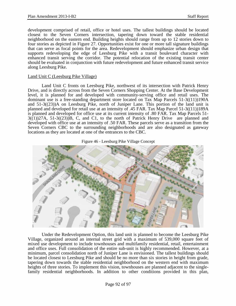
Plan Amendment 2013-I-B2 Staff Report
development comprised of retail, office or hotel uses. The tallest buildings should be located closest to the Seven Corners intersection, tapering down toward the stable residential neighborhood on the eastern end. Building heights should range from up to 12 stories down to four stories as depicted in Figure 27. Opportunities exist for one or more tall signature buildings that can serve as focal points for the area. Redevelopment should emphasize urban design that supports redeveloping the edge of Leesburg Pike with a transit boulevard character with enhanced transit serving the corridor. The potential relocation of the existing transit center should be evaluated in conjunction with future redevelopment and future enhanced transit service along Leesburg Pike.
Land Unit C (Leesburg Pike Village) Land Unit C fronts on Leesburg Pike, northwest of its intersection with Patrick Henry Drive, and is directly across from the Seven Corners Shopping Center. At the Base Development level, it is planned for and developed with community-serving office and retail uses. The dominant use is a free-standing department store located on Tax Map Parcels 51-3((11))190A and 51-3((23))A on Leesburg Pike, north of Juniper Lane. This portion of the land unit is planned and developed for retail use at an intensity of .45 FAR. Tax Map Parcel 51-3((11))189A is planned and developed for office use at its current intensity of .80 FAR. Tax Map Parcels 51-3((1))27A, 51-3((23))B, C, and C1, to the north of Patrick Henry Drive are planned and developed with office use at an intensity of .50 FAR. These parcels serve as a transition from the Seven Corners CBC to the surrounding neighborhoods and are also designated as gateway locations as they are located at one of the entrances to the CBC.
Figure 46 - Leesburg Pike Village Concept
Under the Redevelopment Option, this land unit is planned to become the Leesburg Pike
Village, organized around an internal street grid with a maximum of 539,000 square feet of mixed use development to include townhouses and multifamily residential, retail, entertainment and office uses. Full consolidation of the entire sub-unit is highly recommended. However, at a minimum, parcel consolidation north of Juniper Lane is envisioned. The tallest buildings should be located closest to Leesburg Pike and should be no more than six stories in height from grade, tapering down towards the stable residential neighborhood on the western end with maximum heights of three stories. To implement this vision, townhouses are planned adjacent to the single-family residential neighborhoods. In addition to other conditions provided in this plan,
Page 92 of 97

Plan Amendment 2013-I-B2 Staff Report
redevelopment of this land unit is contingent upon providing a park adjacent to the existing Baileys Upper Elementary School and an additional pocket park on the north side of Juniper Lane. The design of the park space adjacent to the elementary school should explore elements and programming opportunities that would be mutually beneficial to the school and the village. Terraced lawn parcels could also serve as an outdoor classroom space. Sculptural earthworks or climbable public art can add visual character to the village while encouraging physical play. Landscaping can accent the street view while allowing children to encounter nature. The southern park space adjacent to Juniper Lane is positioned to benefit the village as well as the broader community. Elements that would activate this space through all seasons of the year should be considered that would make this a dynamic, attractive space year round. Landscaping that evolves with each season should complement a diversity of seasonal activities such as water features, a small ice skating area, yoga space, small performances, or neighborhood gatherings.
To provide greater connectivity and promote public health through walking, pedestrian
and vehicular interparcel connections should be provided to the school property. Mixed-use residential buildings with ground floor retail and office uses, and an enhanced pedestrian realm for cafes and outdoor seating areas should be oriented to Leesburg Pike and the new local streets. The concept plan envisions an activated village main street with ground floor retail, entertainment, and outdoor gathering spaces in an enhanced pedestrian environment. High quality architecture, building materials, landscape design, and placemaking techniques should be employed to create a unique neighborhood identity that fosters pride in the Seven Corners community. The architectural character of the Leesburg Pike Village should incorporate the mid-century style of the current retail department store structure either through re-use of the circular tower or incorporating design cues to echo the site’s history.
A mix of residential types is envisioned for this land unit with up to 129,000 square feet
of single-family attached, and up to 275,000 square for multifamily residential. Nonresidential uses should include approximately 50,000 square feet of neighborhood-serving office use, approximately 40,000 square feet of neighborhood-serving retail use, and approximately 45,000 square feet of entertainment uses (such as a theater). As an option, up to 100,000 square feet of additional nonresidential use with a commensurate reduction in residential square footage is permitted, and not to exceed the overall cap of 539,000 square feet for the land unit as identified in Figure 26.
To avoid cut-through traffic on neighborhood streets in Sleepy Hollow Manor, Ravenwood and Ravenwood Park, trips generated by uses located north of Juniper Lane should be directed to and from Leesburg Pike for ingress and egress. Trips generated by uses located north of Juniper Lane should be prohibited from accessing Juniper Lane. For parcels south of Juniper Lane, access should be to Juniper Lane and not to Patrick Henry Drive. No vehicular or pedestrian connections are envisioned to Shadeland Drive from this land unit. To protect and maintain the existing character of the neighborhoods, Shadeland Drive should remain as a cul-de-sac with no vehicular or pedestrian connections to Land Unit C. Screening and buffering should be provided that meet or exceeds the requirements of the Zoning Ordinance. Elements that visually block new construction are to be provided and maintained between Land Unit C and the adjacent neighborhoods. Transitional Areas
All of the land units and sub-units described in this section are planned as Transitional Areas, except for Sub-unit F-2, which is planned as a Minimal Change Area. As previously described, Transitional Areas are not planned for immediate redevelopment, but may be considered for such in the future through a separate study process. Minimal Change Areas are not planned for redevelopment and current uses should be retained in the long term.
Page 93 of 97

Plan Amendment 2013-I-B2 Staff Report
Land Unit D This land unit is directly east of the Seven Corners interchange, south of Wilson Boulevard, west of Peyton Randolph Drive and northeast of Arlington Boulevard. It includes the Corner at Seven Corners shopping center, which is planned for, and developed with, community-serving retail use at the current intensity of .25 FAR. Additional parking lot landscaping and pedestrian connections to adjacent uses are encouraged. The eastern portion of this sub-unit includes the Villages at Falls Church Condominiums that is planned for and developed with residential use at 16-20 dwelling units per acre. Land Unit E This land unit is located north of Wilson Boulevard, between the boundaries of the City of Falls Church and Arlington County. It is planned for, and developed with multifamily residential use at a density of 16-20 dwelling units per acre and developed with the Cavalier Club apartments on Tax Map Parcel 51-3((1))43. Neighborhood-serving retail uses planned and developed at an intensity of up to .25 FAR are also present on Tax Map Parcels 51-3((1))38-40. Land Unit F Land Unit F extends south of the Arlington County border to Leesburg Pike and is bisected by Arlington Boulevard. It is bordered to the west by the Seven Corners Shopping Center and Patrick Henry Drive and to the southeast by the Ravenwood Tower apartments and a stable single-family residential neighborhood. The land unit contains a variety of community-serving retail, office and residential uses. Within the overall planning concept described above, the following recommendations apply to specific sub-units of Land Unit F: Sub-unit F-1 This sub-unit is located in the northernmost quadrant of the intersection of Arlington Boulevard and Patrick Henry Drive. It includes a variety of community-serving retail and office uses. Directly east of Patrick Henry Drive is the Willston Center II [Tax Map Parcel 51-4((1))2B and 24C] and additional retail development on Tax Map Parcel 51-4((1))4. These parcels are planned for, and developed with, retail use at an intensity of .35 FAR. The easternmost portion of this sub-unit (Tax Map Parcel 51-4((12))5A) is planned for, and developed with, office use at an intensity of .20 FAR. Office and retail uses within this sub-unit are planned to be retained at their current intensity. Buffering along the northern and eastern edges of this sub-unit is encouraged to screen the adjacent residential uses. Sub-unit F-2 (See Minimum Change Area) Sub-unit F-3 Tax Map Parcels 51-3((18))8A, 8F1, and 8F2, located at the southeast quadrant of the intersection of Arlington Boulevard and Patrick Henry Drive, are planned for and developed with neighborhood-serving retail use up to .35 FAR. Tax Map Parcel 51-3((18))8E is planned for, and developed with hotel use, and should continue at the existing intensity of approximately .50 FAR. The residential townhomes located north of Brook Drive and east of Patrick Henry Drive are planned and developed at 16-20 dwelling units per acre, and should continue at this density to provide a transition to the Minimum Change Area to the south and west (Sub-unit F2).
To provide a transition in land use intensity between Arlington Boulevard and the Lee Boulevard Heights subdivision to the south, Tax Map Parcels 51-4((15))1-21 are planned for townhouse office use at an intensity up to a .35 FAR, well-buffered from the residential uses to
Page 94 of 97

Plan Amendment 2013-I-B2 Staff Report
the south. Tax Map Parcels 51-4((2))(B)1-2, 51-4((2))(A)4-9, and 51-4((1))6 and 8 are planned for office use at an intensity up to .25 FAR, with retention of existing residential structures encouraged to form a transition zone. As an option, this area may be considered for redevelopment with townhouse office uses up to .35 FAR if logical consolidation of parcels is achieved and designed in a manner compatible with the surrounding neighborhood by the development being residential in appearance, building height being limited to four stories, and a 35 foot buffer provided adjacent to single-family residences, which includes a solid wall and effective landscaping. In addition, development proposals should improve the area’s storm water drainage and traffic circulation. These parcels are designated as a gateway location. Land Unit G Land Unit G is centered on and comprises four of the seven corners for which the area is named. The land unit contains an elongated strip of free-standing retail and office uses, most of which front on and have access to Leesburg Pike and Sleepy Hollow Road. It is bordered by the City of Falls Church and Arlington Boulevard to the north, Thorne Road and Leesburg Pike to the east, and stable residential neighborhoods to the west and southwest. The following recommendations apply to the specific sub-units of Land Unit G: Sub-unit G-1 This sub-unit is immediately adjacent to the Seven Corners. The land is divided into two sections: the larger area south of Arlington Boulevard and east of Leesburg Pike is planned for neighborhood-serving retail or office use at an intensity of up to .35 FAR. As an option, land within this sub-unit may be considered for retail and office mixed use at an intensity up to .50 FAR if full consolidation of parcels is achieved. The smaller portion of the sub-unit north of Wilson Boulevard is developed with and planned for neighborhood-serving office use at its current intensity of approximately .10 FAR. Sub-unit G-2 This sub-unit is directly south of Arlington Boulevard, west of its intersection with Leesburg Pike and Sleepy Hollow Road. Parcels fronting Arlington Boulevard are planned for neighborhood-serving retail or office use at an intensity of up to .50 FAR. As an option, retail and office use at an intensity up to .70 FAR may be considered provided that substantial and logical consolidation is achieved, including Tax Map Parcels 51-3((1))6A and 8A and 51-3((5))2 and 3C, and peak-hour vehicular trip generation for the mix of use is determined to be no greater than that for office use at .50 FAR. Sharing of structured parking by adjacent uses should be encouraged. With any redevelopment, access points should be minimized and provided to both the frontage road (Arlington Boulevard ramp) and Sleepy Hollow Road. Tax Map Parcel 51-3((1))9B is separated from land to the north by a substantial change of elevation and is oriented to Sleepy Hollow Road. It is planned for and developed with community-serving office use at the existing intensity. The area to the southwest (Tax Map Parcels 51-3((34))1A-3R) is developed with and planned for townhouse style office use at the existing intensity of .35 FAR. Tax Map Parcel 51-3((1))9A, on Sleepy Hollow Road, is developed with and planned for public facility use as a hospital at the existing intensity of .65 FAR. Sub-unit G-3
This sub-unit is directly south of the intersection of Leesburg Pike and Sleepy Hollow Road. Tax Map Parcels 51-3((13))2B, 38 and 39 fronting on Leesburg Pike between Sleepy Hollow Road and Castle Roads are planned for, and developed with, retail uses at an intensity of
Page 95 of 97

Plan Amendment 2013-I-B2 Staff Report
.15 FAR while the remainder of the sub-unit is planned for and developed with community-serving office uses at an intensity of .90 FAR.
As an option, office use at an intensity up to .50 FAR may be considered for Tax Map Parcels 51-3((13))38 and 39 and/or Tax Map Parcels 51-3((17))2B - 4A4 provided that the grouping of parcels is consolidated. As a further option for these parcels, office use at an intensity of up to .70 FAR may be considered with consolidation of two or more acres. The Seven Corners Fire and Rescue Station is located on Tax Map Parcels 51-2((1))11 and 51-3((15))4. This area is planned for public facility use and serves as a transition between the commercial area to the north and east and the townhouse and single-family neighborhood to the south and east. Sub-unit G-4 Tax Map Parcels 51-3((1))30 and 31, 51-3((11))188A, 51-3((13))5, 10 and 11 has an existing office building that is planned as the county’s first, adaptive-reuse urban public school. This area is planned for public facility use and serves as a transition between the commercial area to the north, the planned mixed-use retail and multifamily development to the south and east, and the existing single-family neighborhood to the west. Land Unit H Land Unit H is a triangular-shaped area bounded by the City of Falls Church to the northeast, South Street to the northwest, and Arlington Boulevard to the south. The area is bordered by a stable residential neighborhood to the northeast and by automobile sales and service uses to the north, in Falls Church. This land unit includes areas planned for, and developed with, neighborhood-serving retail uses at the existing intensity on Tax Map Parcels 51-3((1))2 and 3, and the visually prominent high rise office towers located on Tax Map Parcels 51-3((1))1B and 1E. Tax Map Parcel 51-3((1))1D is planned for a residential and retail mixed-use project. Tax Map Parcel 51-3((1)) is developed with a hotel. The overall planned intensity of A small automobile service use is located on Tax Map Parcel 51-3((1))1A, at the intersection of Arlington Boulevard and South Street. Tax Map Parcels 51-3((1))1A-1E are planned for mixed use and should continue at the same intensity. As an option, Tax Map Parcels 51-3((1))2 and 3, located directly at the intersection of Arlington Boulevard and Hillwood Avenue may be considered for retail and/or office use up to .50 FAR if the two parcels are consolidated and access coordinated with Tax Map Parcels 51-3((1))1B and 1E or provided as far west of the intersection as possible. As a further opinion, the entire sub-unit may be considered for retail/office mixed use up to .70 FAR provided that full consolidation is achieved and higher structures are located to the east, away from the adjacent single-family detached residential areas. At this higher intensity, a traffic study at the time of redevelopment should be performed. With any redevelopment, primary access points should be minimized with parking lots or structures situated to minimize visual and noise impacts on adjacent residential uses. Any redevelopment should also address the Seven Corners CBC future street grid found in the Transportation section to the best of its ability. The type of buffering and screening provided along South Street should be designed to maintain the residential character of this street.
Page 96 of 97
Plan Amendment 2013-I-B2 Staff Report
Minimum Change Area Sub-unit F-2 The multifamily residential uses along Patrick Henry Drive south of Arlington Boulevard and north of Leesburg Pike are planned for, and developed with, residential use at a density of 16-20 dwelling units per acre. These apartments and condominiums are a source of affordable housing and function as a transition between commercial development and other residential development. This residential area of the sub-unit is a Minimal Change Area because although some new infill development may occur within this area, no change is contemplated.”
Page 97 of 97