Embed Size (px)
Citation preview
1 | S t a f f R e p o r t & D r a f t F i n d i n g s – S p r i n g f i e l d 2 0 3 0 P l a n A m e n d m e n t s
Staff Report and Draft Findings Springfield 2030 Metro Plan Amendments
June 15, 2016
Co-applicants: Local File Numbers: City of Springfield Lane County
Springfield File Nos. LRP 2009-00014, TYP 413-00007 Lane County File Nos. PA _____
Request: Amend the Eugene-Springfield Metropolitan Area General Plan (Metro Plan) to adopt the Springfield 2030 UGB amendment; assign plan designations and zoning to newly urbanizable lands; adopt Springfield 2030 Comprehensive Plan Economic and Urbanization policy elements and implementing zoning to establish Springfield’s employment land supply for the planning period 2010-2030. Metro Plan Type II Amendment
Procedure Type: This proposal contains an amendment of the UGB by a city with a population of 2,500 or more that adds more than 50 acres. Pursuant to ORS 197.626 (1)(b), OAR 660-024-0080, OAR 660-025-0175, and ORS 197.610 reviewed by LCDC OAR 660-025-0175 (1)(b), the 2030 Plan amendments are submitted to the Department and Commission for review for compliance with the applicable statewide planning goals, statutes and rules. The proposal was initiated on December 31, 2009 and was prepared to address the requirements of the applicable statutes and rules in effect at that time, including
• ORS 197.298 • HB 4126 • Goal 14 ef. April 28, 2006 OAR 660-015-
0000(14) • Division 24 Urban Growth Boundaries cert.
ef. 4-16-09
I. Nature of the Plan Amendment Request The City of Springfield and Lane County seek approval of Springfield’s evaluation of employment land needs for the planning period 2010-2030. ORS 197.304 (HB 3337) required the establishment of separate Urban Growth Boundaries (UGBs) for Eugene and Springfield and was the impetus for initiating Springfield’s 2030 comprehensive planning work. Springfield’s current UGB was acknowledged in 2011 to provide land to meet the city’s housing needs for the planning period. All of Springfield’s 2010-2030 residential growth needs were met without expanding the UGB — through re-designation of land in the Glenwood redevelopment area and other efficiency measures.

2 | S t a f f R e p o r t & D r a f t F i n d i n g s – S p r i n g f i e l d 2 0 3 0 P l a n A m e n d m e n t s
The proposed Springfield-Lane County 2030 Plan Amendments include the following actions:
• Adopt Exhibit B Springfield 2030 Comprehensive Plan Economic Element and its Technical Supplement — the Springfield Commercial and Industrial Buildable Lands Inventory and Economic Opportunities Analysis (CIBL/EOA) — as Springfield’s comprehensive plan in compliance with Statewide Planning Goal 9, Economic Development. The Economic Element contains city-specific goals, policies, implementation measures and findings to address Springfield’s land needs for economic development and employment growth for the 2010-2030 planning period, replacing Metro Plan Economic Element policies applicable to lands within Springfield’s jurisdictional area;
• Adopt Exhibit C-1 Springfield 2030 Comprehensive Plan Urbanization Element as Springfield’s comprehensive plan in compliance with Statewide Planning Goal 14, Urbanization. The Urbanization Element contains Springfield’s city-specific goals, policies, implementation measures and findings to address land needs for the planning period 2010-2030, replacing Metro Plan Urbanization and Growth Management policies applicable to lands within Springfield’s jurisdictional area;
• Adopt Exhibit C-1 and C-2 amending Springfield Urban Growth Boundary (UGB),1 Springfield UGB map and UGB Technical Supplement depicting and describing the UGB. Amend Metro Plan Boundary to be coterminous with the UGB. (Lane County will amend the Lane County Rural Comprehensive Plan (RCP) boundary to be coterminous with the UGB and Metro Plan Boundary to reflect the boundary change.)
o Expands the Springfield UGB to add approximately 257 suitable acres of employment land on 273 gross acres in two expansion areas – North Gateway and Mill Race.
o Expands the Springfield UGB to include approximately 455 acres of existing public land, parks and open space.
• Adopt Exhibit D amending Metro Plan text:
o Amend Chapter II, Section C Metro Plan Growth Management Goals, Findings, and Policies to add the following paragraph: “Sub-chapter II-C no longer applies to Springfield. In 2016, the City of Springfield and Lane County adopted the Springfield 2030 Comprehensive Plan Urbanization Element, Ordinance No. XXXX and Lane County Ordinance No. XXXX, as Springfield’s comprehensive plan in compliance with Statewide Planning Goal 14, Urbanization. The Urbanization Element contains Springfield’s city-specific goals, policies, implementation
1 All references in this report to amendment of “Springfield UGB”, “UGB amendments” or “UGB expansion” also reference concurrent amendments to the Metro Plan boundary and Lane Rural Comprehensive Plan Boundary to be coterminous with the amended Springfield UGB.
3 | S t a f f R e p o r t & D r a f t F i n d i n g s – S p r i n g f i e l d 2 0 3 0 P l a n A m e n d m e n t s
measures and findings to address land needs for the planning period 2010-2030.”
o Amend Chapter II, Section E Metro Plan Urban and Urbanizable Land to add the following paragraph: “Sub-chapter II-E no longer applies to Springfield. In 2016, the City of Springfield and Lane County adopted the Springfield 2030 Comprehensive Plan Urbanization Element, Ordinance No. XXXX and Lane County Ordinance No. XXXX, as Springfield’s comprehensive plan in compliance with Statewide Planning Goal 14, Urbanization. The Urbanization Element contains Springfield’s city-specific goals, policies, implementation measures and findings to address land needs for the planning period 2010-2030.”
o Amend Metro Plan Chapter III, Section B Metro Plan Economic Element to add the following paragraph: “Sub-chapter III-B no longer applies to Springfield. In 2016, the City of Springfield and Lane County adopted the Springfield 2030 Comprehensive Plan Economic Element, Ordinance No. XXXX and Lane County Ordinance No. XXXX, as Springfield’s comprehensive plan in compliance with Statewide Planning Goal 9, Economic Development. The Economic Element contains city-specific goals, policies, implementation measures and findings to address Springfield’s land needs for economic development and employment growth for the 2010-2030 planning period.”
o Amend Metro Plan Chapter II, Section G Land Use Designations to add a new land use designation applicable to Springfield’s jurisdictional area of responsibility — the Urban Holding Area-Employment (UHA-E) plan designation;
o Amend Metro Plan Chapter II, Section G. Metro Plan Land Use Special Heavy Industrial designation page II-G-8 to delete the Springfield-specific reference to the Natron Special Heavy Industrial (SHI) site; and
o Amend Metro Plan Chapter II, Section G, footnote 7, to add a reference to the subject UGB amendment ordinance.
• Adopt Exhibit A amending Metro Plan Diagram2 to assign Metro Plan designations to
lands added to the UGB: o Assign the “Urban Holding Area – Employment” (UHA-E) Metro plan designation
to approximately 273 acres to meet Springfield’s long range employment land need for 7 employment sites on 223 suitable unconstrained acres;
2 The Metro Plan boundary, Lane Rural Comprehensive Plan boundary and Lane County plan and zoning maps are amended concurrently to reflect the amended UGB, plan and zoning designations shown in Exhibit A and C.
4 | S t a f f R e p o r t & D r a f t F i n d i n g s – S p r i n g f i e l d 2 0 3 0 P l a n A m e n d m e n t s
o Assign the “Natural Resource” (NR) Metro plan designation to approximately 53
acres of land within the McKenzie River Floodway in the North Gateway area;
o Assign the “Public/Semi Public” (P/SP) Metro plan designation to approximately 455 acres of existing publicly-owned land, parks and open space.
• Adopt Exhibit E amending Springfield Development Code Chapter 3 Land Use Districts establishing Section 3.2-900 Agriculture—Urban Holding Area (AG) Zoning District to implement the Urban Holding Area – Employment plan designation and Natural Resource plan designation.
• Adopt Exhibit A-3 amending Springfield Zoning Map to assign Springfield zoning to lands
added to UGB o Assign Agriculture—Urban Holding Area Zoning District to lands designated
Urban Holding Area- Employment (UHA-E) and Natural Resource (NR); o Assign Public Land and Open Space (PLO) Zoning District to lands designated
Public/Semi Public.
This proposal also requires concurrent actions by Lane County to amend the Lane County Rural Comprehensive Plan. These actions are addressed in Lane County’s staff report File No. XXXX
o Amend Lane County Rural Comprehensive Plan boundary to be coterminous with the UGB and Metro Plan Boundary to reflect the boundary change.
o Amend Lane County’s plan designation and zoning maps to reflect the 2030 Plan Metro Plan Diagram and Springfield Zoning Map amendments.
5 | S t a f f R e p o r t & D r a f t F i n d i n g s – S p r i n g f i e l d 2 0 3 0 P l a n A m e n d m e n t s
Contents I. Nature of the Plan Amendment Request ......................................................................... 1
II. Background ...................................................................................................................................... 7
a. Procedural Requirements for Processing UGB Amendments .................................. 10
b. Procedural Requirements for Processing City-specific Metro Plan Amendments 15
III. Applicable Statewide Planning Goals ............................................................................. 17
IV. Statewide Planning Goal 9: Economy of the State ........................................................ 19
a. Economic Opportunities Analysis [OAR 660-009-0015] ............................................. 34
b. Industrial and Other Employment Development Policies [OAR 660-009-0020] ..... 64
c. Policies committing the city to designate an adequate number of sites of suitable sizes, types and locations [OAR 660-009-0020] ................................................ 68
d. Employment Land Need - Uses with Special Siting Characteristics [OAR 660-009-0025(8)] ......................................................................................................................... 89,107
e. Plan Designations and Zoning [OAR 660-009-0025, OAR 660-024-0050(6)] ..... 94,107
f. Identification of Needed Sites and Site Characteristics [OAR 660-009-0025(1)] .. 100
V. Statewide Planning Goal 14: Urbanization .................................................................... 121
a. Employment Land Need and Response to Deficiency [OAR 660-015-0000(14), OAR 660-024-0040(1), OAR 660-024-0040(5), OAR 660-024-0050(1), OAR 660-024-0050(4)] .............................................................................................................................. 121
b. Relationship between Goal 9 and Goal 14 ............................................................. 121
c. Capacity to Absorb Growth within the Existing UGB .............................................. 124
d. Division 24 Urban Growth Boundaries ...................................................................... 134
e. Determination of 20-Year Employment Land Need [OAR 660-024-0040(5), OAR 660-024-0050(4), OAR 660-024-0050(5)] ......................................................................... 142
f. Assignment of Appropriate Urban Plan Designations and Interim Zoning [OAR 660-024-0050(60] ...................................................................................................................... 154
VI. Boundary Location Alternatives Analysis [OAR 660-024-0060] .................................. 156
Site Suitability Characteristics [OAR 660-024-0060(1) and (4) ..................................... 158
Priority of Land as Specified in ORS 197.298.................................................................. 162
Analysis of Second Priority Land: Exception Area or Non-Resource Land .............. 172
Second Priority Land Public Facilities and Services Analysis ....................................... 237
Analysis of Third Priority Land: Marginal Land ............................................................... 268
6 | S t a f f R e p o r t & D r a f t F i n d i n g s – S p r i n g f i e l d 2 0 3 0 P l a n A m e n d m e n t s
Third Priority Land Public Facilities and Services Analysis ............................................ 278
Analysis of Fourth Priority Lands Designated Agriculture or Forestry ......................... 290
Goal 14 Locational Factors ............................................................................................. 380
Goal 14 Conclusion .......................................................................................................... 411
VIII. Compliance with Metro Plan and Other Planning Goals ............................................ 415
Goal 15 Willamette River Greenway ............................................................................. 424
Goal 1 Citizen Involvement ............................................................................................. 430
Goal 2 Land Use Planning ............................................................................................... 431
Goal 5 Natural Resources, Scenic and Historic Areas, and Open Spaces .............. 435
Goal 6 Air, Water and Land Resources Quality ........................................................... 448
Goal 7 Areas Subject to Natural Hazards .................................................................... 451
Goal 8 Recreational Needs ............................................................................................ 455
Goal 11 Public Facilities and Services ............................................................................ 461
Goal 12 Transportation .................................................................................................... 481
Goal 13 Energy Conservation ......................................................................................... 517
The proposed 2030 Plan amendments (2030 Plan) implement ORS 197.707 “to enhance economic development and opportunity for the benefit of all citizens”; and the Land Conservation and Development Commission’s requirements for comprehensive plans pursuant to ORS 197.712: “in carrying out statewide comprehensive land use planning, the provision of adequate opportunities for a variety of economic activities throughout the state is vital to the health, welfare and prosperity of all the people of the state.”
The 2030 Plan addresses the comprehensive planning requirements in ORS 197.712(2)(a)-(d) by adopting city-specific comprehensive plan elements including: (a) the Springfield Commercial and Industrial Buildable Lands Inventory and Economic Opportunities Analysis — the required analysis of Springfield’s economic patterns, potentialities, strengths and deficiencies as they relate to state and national trends; (b) the Springfield 2030 Comprehensive Plan Economic Element — containing the City’s policies concerning the economic development opportunities in the community; (c) & (d) the Springfield 2030 Comprehensive Plan Urbanization Element — containing policies, UGB Amendment, plan designations and implementing land use regulations to provide for at least an adequate 20-year supply of sites and suitable sizes, types, locations and service levels for industrial and commercial uses consistent with plan policies. As allowed by ORS 197.712(2)(g)(B), the 2030 Plan proposes a modest change to the Springfield UGB to provide reasonable opportunities for urban commercial and industrial needs over time. The City’s findings under Goals 11, 12 and 14 address the required coordination with public facilities and transportation planning.

7 | S t a f f R e p o r t & D r a f t F i n d i n g s – S p r i n g f i e l d 2 0 3 0 P l a n A m e n d m e n t s
The 2030 Plan UGB amendment, plan policies, plan designations and land use regulations implement Goal 14 Urbanization by providing urbanizable3 land in the Springfield UGB designated for urban development needs — based on a demonstrated need for employment opportunities, livability, public facilities, parks and open space for the planning period 2010-2030. The 2030 Plan identifies Springfield’s economic development objectives, provides public policies to support desired outcomes, and designates a 20-year supply of suitable employment land with specific site characteristics to meet identified needs. Prior to expanding the UGB, the City conducted the thorough and complete inventory and analysis required by Goal 9 administrative rules to demonstrate that all land needs cannot reasonably be accommodated on land already inside the UGB. [OAR 660-015-0000(14)
II. Background Requirements for land use planning within the Eugene-Springfield Metro area were established in 2007 when the Oregon Legislature adopted House Bill 3337. ORS 197.304 (Lane County accommodation of needed housing) established a mandate requiring Springfield to determine its population’s 20-year need for housing separately from Eugene and to establish a Springfield Urban Growth Boundary (UGB) to designate land to meet housing needs. Although the text of ORS 197.304 refers only to the cities’ accommodation of residential land needs, the requirement for separate UGBs carries with it the implicit need for the cities to independently plan for other land needs as well, including employment growth needs, as defined by Goal 9. Evaluation of Land Needs for 2010-2030 Planning Period. As described above, the first step to begin this compliance process was to adopt separate population forecasts into the Metro Plan (acknowledged in 2010) in order to establish the 20-year population to be used in the 2030 Plan. In 2007, Springfield began concurrent land studies (Residential Land Study and Commercial and Industrial Lands Study) to evaluate Springfield’s jurisdictional area of the Metro UGB for 2010-2030 housing and employment needs. The City commenced the Springfield 2030 Plan’s planning period on year 2010 to 1) mesh seamlessly with the County’s adopted coordinated population forecast period; 2) to meet the City’s obligation to complete the housing inventory, analysis and determination before January 1, 2010, and 3) to closely coordinate Springfield’s residential and commercial and industrial land inventories and analyses processes — that would serve as the factual bases for the Springfield UGB and respective Springfield 2030 Comprehensive Plan policy elements. The planning period 2010-2030 is consistent with the requirements of OAR 660-024-0040(2)(a) and (b).
3 Goal 14: “Urbanizable Land. Land within urban growth boundaries shall be considered available for urban development consistent with plans for the provision of urban facilities and services. Comprehensive plans and implementing measures shall manage the use and division of urbanizable land to maintain its potential for planned urban development until appropriate public facilities and services are available or planned. [OAR 660-015-0000(14)]

8 | S t a f f R e p o r t & D r a f t F i n d i n g s – S p r i n g f i e l d 2 0 3 0 P l a n A m e n d m e n t s
Initiation of Springfield 2030 Plan Post Acknowledgement Plan and UGB Amendments. The City and Lane County jointly submitted Notice of a Proposed Change to a Comprehensive Plan or Land Use Regulation as described in OAR 660-018-0020 and OAR 660-018-0021 concerning the evaluation or amendment of the Springfield UGB to DLCD on December 31, 2009. The first evidentiary hearing was conducted jointly by the Springfield and Lane County Planning Commissions beginning on February 17, 2010 and closing on May 4, 2010. The Notice was submitted to DLCD more than 45 days prior to the hearing.
Applicability of Division 24 Rule to Springfield UGB Amendment. In 2016 HB 4126 was enacted to allow cities like Springfield that had already initiated a UGB amendment, to continue to use the administrative rules in effect at the time of initiation. Also, subsequent to initiation of the amendment, and subsequent to the first evidentiary hearing on the amendments, the Oregon legislature adopted new rules to “clarify procedures and requirements of Goal 14 regarding a local government adoption or amendment of an urban growth boundary (UGB).” Those rules went into effect January 1, 2016 and included the following provision exempting cities who had initiated UGB amendments prior to that effective date.
HB 4126 states :
Notwithstanding ORS 197A.320, a city outside of Metro that submitted to the “Director of the Department of Land Conservation and Development, pursuant to ORS 197.610, a proposed change to an acknowledged comprehensive plan or a land use regulation that included an evaluation or an amendment of its urban growth boundary, or that received approval of a periodic review work program that included a work task to amend or evaluate its urban growth boundary pursuant to ORS 197.633, prior to January 1, 2016, but did not complete the evaluation or amendment of its urban growth boundary prior to January 1, 2016 may complete the evaluation or amendment pursuant to statutes and administrative rules in effect on June 30, 2013.”
OAR 660-024-0000(4) states:
“The rules in this division adopted on December 4, 2015, are effective January 1, 2016, except that a local government may choose to not apply the amendments to rules in this division adopted December 4, 2015 to a plan amendment concerning the amendment of a UGB, regardless of the date of that amendment, if the local government initiated the amendment of the UGB prior to January 1, 2016.”
OAR 660-024-0000 (3)(b) states:
“For purposes of this rule, "initiated" means that the local government either:
(A) Issued the public notice specified in OAR 660-018-0020 for the proposed plan amendment concerning the evaluation or amendment of the UGB; or

9 | S t a f f R e p o r t & D r a f t F i n d i n g s – S p r i n g f i e l d 2 0 3 0 P l a n A m e n d m e n t s
(B) Received LCDC approval of a periodic review work program that includes a work task to evaluate the UGB land supply or amend the UGB;
(c) A local government choice whether to apply this division must include the entire division and may not differ with respect to individual rules in the division.”
The City and Lane County initiated amendment of the UGB as described in OAR 660-024-000 (3)(b)(A) and as defined in OAR 660-018-0020 prior to January 1, 2016, thus the City may choose to not apply the amendments to rules in division 24 adopted December 4, 2015 to its plan amendment concerning the amendment of a UGB. The City chose to complete its UGB amendment process under the rules in effect prior to January 1, 2016.
2030 Plan Phased Adoption Process/ 2011 Acknowledgement of Springfield UGB and Goal 10 Housing Element (ORS 197.296). Given the complexity of actions involved in the 2030 Plan proposals and the need for timely compliance with ORS 197.3044, Springfield chose to phase adoption of the 2030 Plan amendments. On June 20, 2011, Springfield and Lane County co-adopted amendments to the Eugene-Springfield Metro Plan (Springfield Ordinance 6268, Lane County Ordinance PA 09-6018) — the Springfield 2030 Refinement Plan Residential Land Use and Housing Element and its Technical Supplement Residential Land Use and Housing Needs Analysis (RLHNA) and a separate Springfield Urban Growth Boundary pursuant to ORS 197.304 Lane County accommodation of needed housing. The amendments were acknowledged on August 9, 2011.5 Prior to that action, Springfield shared a UGB with Eugene.
Springfield’s 2010-2030 Residential Growth needs were met without expanding the UGB, by adopting residential land efficiency measures into the City’s Development Code and by redesignating land for High Density Residential (HDR) mixed-use purposes to meet the identified HDR deficit. Springfield’s current UGB is based on the adopted 20-year population forecast for the urban area described in OAR 660-024-0030. Springfield’s current UGB did not address employment land needs for the 2010-2030 planning period. The subject proposal seeks approval for its evaluation of land needed for employment.
IIa. Procedural Requirements for Processing UGB Amendments The following section of this report demonstrates compliance with the applicable procedural requirements.
4 The adoption of the Springfield UGB pursuant to ORS 197.304(1)(a), and a Buildable Land Inventory and Housing Needs Analysis pursuant to ORS 197.304(1)(b), came under the “notwithstanding clause” of ORS 197.304(1), which provides: “Notwithstanding an intergovernmental agreement pursuant to ORS 190.003 to 190.130 or acknowledged comprehensive plan provisions to the contrary, [Springfield] shall meet its obligation under ORS 197.295 to 197.314 separately from any other city within Lane County.” 5 DLCD Notice of Adopted Amendment, DLCD File Number 012-09, July 5, 2011.
10 | S t a f f R e p o r t & D r a f t F i n d i n g s – S p r i n g f i e l d 2 0 3 0 P l a n A m e n d m e n t s
ORS 197.626(1)(b) LCDC Review Required for UGB Amendments (1) A local government shall submit for review and the Land Conservation and Development Commission shall review the following final land use decisions in the manner provided for review of a work task under ORS 197.633 (Two phases of periodic review):
(b) An amendment of an urban growth boundary by a city with a population of 2,500 or more within its urban growth boundary that adds more than 50 acres to the area within the urban growth boundary;
Springfield — a city with a population of 2,500 or more — submitted a land use proposal that adds 792.5 acres — more than 50 acres — to the area within the urban growth boundary. Therefore, the UGB amendment is subject to ORS 197.626 (1)(b) and reviewed by LCDC. A final order of the commission under this section may be appealed to the Court of Appeals in the manner described in ORS 197.650 (Appeal to Court of Appeals) and 197.651 (Appeal to Court of Appeals for judicial review of final order of Land Conservation and Development Commission).
OAR 660-024-0080 LCDC Review Required for UGB Amendments “A metropolitan service district that amends its UGB to include more than 100 acres, or a city with a population of 2,500 or more within its UGB that amends the UGB to include more than 50 acres shall submit the amendment to the Commission in the manner provided for periodic review under ORS 197.628 to 197.650 and OAR 660-025-0175.”
Springfield’s proposal is a post-acknowledgement plan amendment of the Eugene-Springfield Metropolitan Area General Plan that is “reviewed in the manner of periodic review” because it includes a UGB amendment larger than 50 acres. Springfield and Eugene staff met with former DLCD Director Richard Whitman and DLCD staff several times between 2009 and 2010 to discuss how the cities would respond to the ORS 197.304 mandate to adopt separate urban growth boundaries and to confirm the Department’s acceptance of the approach to be taken by both cities to establish and amend UGBs, consistent with each city’s jurisdictional area of responsibility as specified in the acknowledged Metro Plan. Between 2013 and 2015 City planning staff met with DLCD staff to confirm that submittal of the subject proposal is not subject to periodic review work task submittal requirements and provisions of the statutes or administrative rules applicable only to the periodic review process.
660-025-0175 Review of UGB Amendments and Urban Reserve Area Designations
“(1) A local government must submit the following land use decisions to the department for review for compliance with the applicable statewide planning goals, statutes and rules in the manner provided for review of a work task under ORS 197.633:
11 | S t a f f R e p o r t & D r a f t F i n d i n g s – S p r i n g f i e l d 2 0 3 0 P l a n A m e n d m e n t s
(b) An amendment of an urban growth boundary by a city with a population of 2,500 or more within its urban growth boundary that adds more than 50 acres to the area within the urban growth boundary; (2) The standards and procedures in this rule govern the local government process and submittal, and department and commission review. (3) The local government must provide notice of the proposed amendment according to the procedures and requirements for post-acknowledgement plan amendments in ORS 197.610 and OAR 660-018-0020. (4) The local government must submit its final decision amending its urban growth boundary, or designating urban reserve areas, to the department according to all the requirements for a work task submittal in OAR 660-025-0130 and 660-025-0140. (5) Department and commission review and decision on the submittal from the local government must follow the procedures and requirements for review and decision of a work task submittal in OAR 660-025-0085, and 660-025-0140 to 660-025-0160.”
The Springfield 2030 Plan proposal contains an amendment of the UGB by a city with a population of 2,500 or more that adds more than 50 acres. Pursuant to OAR 660-025-0175, the UGB Amendment proposal is submitted to the Department and Commission for review for compliance with the applicable statewide planning goals, statutes and rules in the manner provided for review of UGB amendments.
ORS 197.610 Submission of proposed comprehensive plan or land use regulation changes to Department of Land Conservation and Development
“(1) Before a local government adopts a change, including additions and deletions, to an acknowledged comprehensive plan or a land use regulation, the local government shall submit the proposed change to the Director of the Department of Land Conservation and Development. The Land Conservation and Development Commission shall specify, by rule, the deadline for submitting proposed changes, but in all cases the proposed change must be submitted at least 20 days before the local government holds the first evidentiary hearing on adoption of the proposed change. The commission may not require a local government to submit the proposed change more than 35 days before the first evidentiary hearing.
(3) Submission of the proposed change must include all of the following materials:
12 | S t a f f R e p o r t & D r a f t F i n d i n g s – S p r i n g f i e l d 2 0 3 0 P l a n A m e n d m e n t s
(a) The text of the proposed change to the comprehensive plan or land use regulation implementing the plan;
(b) If a comprehensive plan map or zoning map is created or altered by the proposed change, a copy of the map that is created or altered;
(c) A brief narrative summary of the proposed change and any supplemental information that the local government believes may be useful to inform the director or members of the public of the effect of the proposed change;
(d) The date set for the first evidentiary hearing;”
Springfield’s proposal includes comprehensive plan and land use regulation changes that are amendments to the acknowledged Eugene–Springfield Metro Plan, therefore the post-acknowledgement procedures of ORS 197.610 are applicable.
660-018-0020 Notice of a Proposed Change to a Comprehensive Plan or Land Use Regulation
“(1) Before a local government adopts a change to an acknowledged comprehensive plan or a land use regulation, unless circumstances described in OAR 660-018-0022 apply, the local government shall submit the proposed change to the department, including the information described in section (2) of this rule. The local government must submit the proposed change to the director at the department’s Salem office at least 35 days before holding the first evidentiary hearing on adoption of the proposed change. (2) The submittal must include applicable forms provided by the department, be in a format acceptable to the department, and include all of the following materials: (a) The text of the proposed change to the comprehensive plan or land use regulation implementing the plan, as provided in section (3) of this rule; (b) If a comprehensive plan map or zoning map is created or altered by the proposed change, a copy of the relevant portion of the map that is created or altered; (c) A brief narrative summary of the proposed change and any supplemental information that the local government believes may be useful to inform the director and members of the public of the effect of the proposed change; (d) The date set for the first evidentiary hearing; (e) The notice or a draft of the notice required under ORS 197.763 regarding a quasi-judicial land use hearing, if applicable; and (f) Any staff report on the proposed change or information that describes when the staff report will be available and how a copy may be obtained. (3) The proposed text submitted to comply with subsection (2)(a) of this rule must include all of the proposed wording to be added to or deleted from the acknowledged plan or land use regulations. A general description of the proposal or its purpose, by itself, is not sufficient. For map changes, the material submitted to comply with Subsection (2)(b) must include a graphic depiction of the change; a legal description, tax
13 | S t a f f R e p o r t & D r a f t F i n d i n g s – S p r i n g f i e l d 2 0 3 0 P l a n A m e n d m e n t s
account number, address or similar general description, by itself, is not sufficient. If a goal exception is proposed, the submittal must include the proposed wording of the exception. (4) If a local government proposes a change to an acknowledged comprehensive plan or a land use regulation solely for the purpose of conforming the plan and regulations to new requirements in a land use statute, statewide land use planning goal, or a rule implementing the statutes or goals, the local government may adopt such a change without holding a public hearing, notwithstanding contrary provisions of state and local law, provided: (a) The local government provides notice to the department of the proposed change identifying it as a change described under this section, and includes the materials described in section (2) of this rule, 35 days before the proposed change is adopted by the local government, and (b) The department confirms in writing prior to the adoption of the change that the only effect of the proposed change is to conform the comprehensive plan or the land use regulations to the new requirements. (5) For purposes of computation of time for the 35-day notice under this rule and OAR 660-018-0035(1)(c), the proposed change is considered to have been “submitted” on the day that paper copies or an electronic file of the applicable notice forms and other documents required by section (2) this rule are received or, if mailed, on the date of mailing. The materials must be mailed to or received by the department at its Salem office.”
Notice of the proposed 2030 Plan amendments was initially submitted to DLCD on December 31, 2009. The first evidentiary hearing was conducted jointly by the Springfield and Lane County Planning Commissions February 17-May 4, 2010.
Notice of the proposed AG Zone development code amendment (Ordinance Exhibit E) to implement 2030 Plan policies was submitted to DLCD on November 15, 2013. The first evidentiary hearing on the AG Zone was conducted by the Springfield Planning Commission on December 18, 2013. The Commission ordered a recommendation of approval to the Springfield City Council and Lane County Board, signed December 18, 2013.6
In addition to the applicable forms, the submittal included the text of the proposed wording of 2030 Plan Economic and Urbanization Element text; maps graphically depicting the proposed UGB amendment; proposed wording of AG zone land use regulations; the date set for the hearing; and description of the proposed change or information describing when the staff report would be available and how a copy could be obtained.
The City and Lane County submitted a revised Form 2 Notice of a Proposed Change to a Comprehensive Plan or Land Use Regulation to DLCD on date July x, 2016. EXHIBIT X
6 Springfield File No. TYP413-00007
14 | S t a f f R e p o r t & D r a f t F i n d i n g s – S p r i n g f i e l d 2 0 3 0 P l a n A m e n d m e n t s
In addition to the applicable forms, the revised submittal included the text of the proposed wording of 2030 Plan Economic and Urbanization Element text; proposed wording of Metro Plan text amendments; maps graphically depicting the proposed UGB amendment, Metro Plan designations and zoning map amendments; proposed wording of AG zone land use regulations; the date set for the final hearing; Exhibit F staff report describing the proposal and draft findings. The notice contained information describing when the staff report will be available and how a copy may be obtained. The public hearings were conducted jointly by the Springfield City Council and Lane County Board of Commissioners on September 12, 2016 and ________, 2016. Local decision dates: X and X. Description of public hearing procedure here after completion of the local adoption proceedings and closing of the record. The City and Lane County submitted the Form 4 Notice of Adopted Change to an Urban Growth Boundary to DLCD on ____, 2016, after the amendment was adopted by the City of Springfield and Lane County. Both ordinances were attached to DLCD Form 4. EXHIBIT X AND X
The local record compiled after completion of the local adoption proceedings and closing of the record exceeds 2,000 pages. The submittal includes a detailed index listing all items in the local record and indicating whether or not the item is included in the submittal. EXHIBIT X As required under OAR 660-025-0130, all items in the local record are made available for public review during the period for submitting objections under OAR 660-025-0140. The director or commission may require a local government to submit any materials from the local record not included in the initial submittal. On date X, 2016, the City mailed notice of the decision to a list of persons who participated in local hearings or requested notice of final decision in writing. The mailed notice used sample text provided for local government notice on page 3 of DLCD Form 4 “Sample Notice to Local Parties”, and included the content required by OAR 660-025-0140. EXHIBIT X The submittal includes a list of persons who participated in local hearings or requested notice of final decision in writing. EXHIBIT X On date X ,the City and Lane County submitted the Form 4 Notice of Adopted Change to an Urban Growth Boundary that includes all materials listed on the Form 4 checklist, in compliance with OAR 660-025-0130.
Conclusion. The City and Lane County provided notice of the proposed UGB amendment according to the applicable procedures and requirements for UGB and comprehensive plan amendments.

15 | S t a f f R e p o r t & D r a f t F i n d i n g s – S p r i n g f i e l d 2 0 3 0 P l a n A m e n d m e n t s
IIb. Procedural Requirements for Processing City-specific Metro Plan Amendments Procedural requirements for processing Metro Plan amendments are described in Metro Plan Chapter IV. The amendment procedures found in Chapter IV are implemented through each jurisdiction’s local land use codes. Sections 5.2-115 Notice, 5.14-135 and 5.14-140 of the Springfield Development Code and Lane Code Sections 12.205 through 12.225 contain the amendment procedures and policies found in Chapter IV of the Metro Plan. Section 5.14-135 of the Springfield Development Code and Section 12.225 of the Lane Code have the same Metro Plan amendment criteria; consistency with the applicable Statewide Planning Goals and the proposed amendment cannot make the Metro Plan internally inconsistent. This staff report demonstrates that the Springfield UGB Amendment and 2030 Comprehensive Plan economic and urbanization policy elements are consistent with the applicable criteria by addressing the applicable Statewide Planning Goals. Page iii of the Preface to the Metro Plan explains how Springfield, Eugene and Lane County are pursuing separate city specific comprehensive plans in order to comply with ORS 197.304. As each city develops its own city specific comprehensive plan, the Metro Plan will be amended several times to reflect the evolving extent to which it continues to apply to each jurisdiction. When Eugene or Springfield adopts a city-specific plan to independently address a planning responsibility that was previously addressed on a regional basis in the Metro Plan, that city will also amend the Metro Plan to specify which particular provisions of the Metro Plan will cease to apply within that city. The Springfield UGB amendment and accompanying economic and urbanization elements do not make the Metro Plan internally inconsistent because this amendment also includes Metro Plan text amendments that inform the reader when a specific section of the Metro Plan no longer applies to Springfield because it has adopted a city specific comprehensive plan provision addressing that issue. Therefore, the Springfield UGB amendment is consistent with the Metro Plan amendment criteria set out in the Springfield Development Code and Lane Code that requires Metro Plan amendments to not make the Metro Plan internally inconsistent. Metro Plan amended to enable Springfield and Eugene comprehensive planning. In 2014, the Eugene-Springfield Metropolitan Area General Plan (Metro Plan) text was amended to allow Metro jurisdictions the autonomy to make city-specific planning decisions. The amendments provide policy support for the ORS 197.304 mandate enabling Springfield and Eugene to take separate comprehensive planning actions to co-adopt (with Lane County) their respective Urban Growth Boundaries, land need determinations, comprehensive plan designations and policies. The “Metro Plan Enabling Amendments” were adopted by all three jurisdictions (Local file numbers Eugene: MA 14-2, Springfield: TYP414-00005, Lane Co: PA1313) and acknowledged by DLCD on December 5, 2014.
16 | S t a f f R e p o r t & D r a f t F i n d i n g s – S p r i n g f i e l d 2 0 3 0 P l a n A m e n d m e n t s
The amendments were prepared by the three Metro Plan partner jurisdictions in anticipation that Springfield and Eugene will eventually have their own city-specific comprehensive plans to address the aspects of land use planning that the cities conduct independently of one another (e.g. residential and employment land studies and policies). To support achievement of that those ends, the Metro Plan as revised in 2014 sets forth procedures for adopting city-specific plan changes — including UGB amendments — such as the subject proposal. As required by Metro Plan IV-2, Policy 3, “A proposed amendment to the Metro Plan shall be classified as a Type I, Type II or Type III amendment depending upon the number of governing bodies required to approve the decision.” The subject amendment of the Metro Plan is processed as a Type II Amendment requiring approval by Springfield and Lane County, as described in Metro Plan page IV-2, Policy 5A and b:
“A Type II Amendment requires approval by two governing bodies. The governing bodies in a Type II are the home city and Lane County. Eugene is the home city for amendments west of I-5, and Springfield is the home city for amendments east of I-5: a. Type II Diagram Amendments include: i. Amendments to the Metro Plan Diagram for the area between a city limit and the Plan Boundary; ii. A UGB or Metro Plan Boundary amendment east or west of I-5 that is not described as a Type III amendment. b. Type II Text Amendments include: i. Amendments that are non site specific and apply only to Lane County and one of the cities; 7 ii. Amendments that have a site specific application between a city limit of the home city and the Plan Boundary;”
The subject 2030 Plan amendments to the Metro Plan include Type II diagram amendments (UGB and Metro Plan Boundary, plan designations) applicable to lands east of I-5 and text amendments applicable only to lands east of I-5. As documented in the local record, and consistent with Sections 5.2-115 Notice, 5.14-135 and 5.14-140 of the Springfield Development Code and Lane Code Sections 12.205 through 12.225, the City initiated the amendment jointly with Lane County and notified all three governing bodies of the amendment, as required in Metro Plan IV-4, 8a. The Springfield and Lane County Planning Commissions conducted a
7 This includes an amendment to Metro Plan to specify that a particular provision does not apply within the UGB on one side of I-5, or within the Metro Plan boundary on one side of I-5, as may be the case as Eugene and Springfield consider a regional planning program that includes the adoption of city-specific comprehensive plans to address some of the land use issues that have historically been addressed in the Metro Plan.

17 | S t a f f R e p o r t & D r a f t F i n d i n g s – S p r i n g f i e l d 2 0 3 0 P l a n A m e n d m e n t s
joint public hearing and forwarded recommendations to their respective elected bodies as required in Metro Plan IV-4,7b. As provided in Metro Plan IV-4,10:
“…Until a city has adopted a city-specific comprehensive plan that explicitly supplants the relevant portion of the Metro Plan, that city’s refinement and functional plans must be consistent with the Metro Plan. After a city has adopted a city-specific comprehensive plan that explicitly supplants the relevant portion of the Metro Plan, that city’s refinement and functional plans must be consistent with its city-specific comprehensive plan (instead of the Metro Plan). In any case, should inconsistencies occur between the applicable comprehensive plan and a refinement or functional plan, the applicable comprehensive plan is the prevailing policy document.”
The Springfield 2030 Economic and Urbanization Elements, UGB and Metro Plan boundary amendments explicitly supplant the relevant and UGB portions of the Metro Plan as described in the subject Ordinance and in this report.
III. Applicable Statewide Planning Goals
OAR 660-015-0000
Statewide Planning Goals 1, 2, 5, 6, 7, 8, 9, 11, 12, 13, 14 and 15 are applicable to this request. Because the proposal amends the comprehensive plan to meet economic development objectives, draft findings demonstrating compliance with the Goal 9 (Economy) and Goal 14 (Urban growth boundaries) administrative rules are provided first, followed by findings for remaining applicable statewide planning goals and rules.
• Goal 9 (Economy of the State) applies to adoption of local economic studies such as the Springfield CIBL/EOA. The Land Conservation and Development Commission (LCDC) adopted the Economic Development administrative rule (OAR Chapter 660, Division 009) to interpret Goal 9 and ORS 197.712.
• Goal 14 (Urbanization) governs amendment to urban growth boundaries; the Urban Growth Boundaries administrative rule (OAR Chapter 660, Division 024) provides detailed guidance for making UGB amendments.
• Goal 1 (Citizen Involvement) and Goal 2 (Land Use Planning) are procedural goals that require citizen involvement in all phases of the planning process; an adequate factual base for considering alternatives courses of action; coordination among the city, county and state agencies; adoption of ultimate policy choices in the Comprehensive Plan; and consistency between the Comprehensive Plan and implementing land use regulations.
• Goals 5 (Natural Resources), 7 (Natural Hazards), 8 (Parks and Recreation) and 15 (Willamette River Greenway) require local governments to address wetland and riparian resource areas, regulate development within the flood plain, plan to meet park and recreational needs, and protect
18 | S t a f f R e p o r t & D r a f t F i n d i n g s – S p r i n g f i e l d 2 0 3 0 P l a n A m e n d m e n t s
the Willamette River Greenway. Wetland and riparian corridors identified in the National Local Wetland Inventory (LWI), Metro Natural Resources Study (Springfield Ordinance 6150, Lane County Ordinance PA1215) are accounted for in the suitable employment lands inventory. As noted in the Goal 5 section of this report, additional waterways and wetlands have been identified through this planning process and have been considered.
• Goal 6 (Air, Water, and Land Resource Quality), Goal 11 (Public Facilities and Services), Goal 12 (Transportation) and Goal 13 (Energy Conservation) also apply.
• Goal 11 (Public Facilities and Services), Goal 12 (Transportation) and Goal 13 (Energy Conservation) also apply. Goal 12 is implemented by the Transportation Planning Rule (OAR Chapter 660, Division 012).
Springfield’s current UGB — acknowledged in 2011 — provides land to accommodate the housing needs of the projected 2010-2030 population. The proposal does not affect the residential buildable lands inventory acknowledged in 2011. No re-designation of residential land is proposed in this action. All designated residential land in the current UGB is needed to accommodate the housing needs of projected 2010-2030 population. Springfield’s current proposal does not require the application of a statewide planning goal relating to buildable lands for residential use. Therefore, Goal 10 is not applicable to this proposal.
IV. Statewide Planning Goal 9: Economy of the State
OAR 660-015-0000(9) To provide adequate opportunities throughout the state for a variety of economic activities
vital to the health, welfare, and prosperity of Oregon's citizens.
The City’s 2030 Plan Amendments adopt the City of Springfield 2030 Comprehensive Plan Economic Element (2030 Economic Element) and its Technical Supplement — the Springfield Commercial and Industrial Buildable Lands Inventory and Economic Opportunities Analysis Final Report dated August 2015 (CIBL/EOA)— as Springfield’s comprehensive plan in compliance with Statewide Planning Goal 9, Economic Development.
As required under Goal 9:
Comprehensive plans and policies shall contribute to a stable and healthy economy in all regions of the state. [OAR 660-015-0000(9)] (emphasis added)
OAR 660-009-0000 Intent and Purpose
Goal 9, as implemented through the Division 9 Administrative Rules, has the following intent and purpose:
19 | S t a f f R e p o r t & D r a f t F i n d i n g s – S p r i n g f i e l d 2 0 3 0 P l a n A m e n d m e n t s
The intent of the Land Conservation and Development Commission is to provide an adequate land supply for economic development and employment growth in Oregon. The intent of this division is to link planning for an adequate land supply to infrastructure planning, community involvement and coordination among local governments and the state. The purpose of this division is to implement Goal 9, Economy of the State (OAR 660-015-0000(9), and ORS 197.712(2)(a) to (d). This division responds to legislative direction to assure that comprehensive plans and land use regulations are updated to provide adequate opportunities for a variety of economic activities throughout the state (ORS 197.712(1)) and to assure that comprehensive plans are based on information about state and national economic trends (ORS 197.717(2)). [OAR 660-009—0000] (emphasis added)
The Springfield 2030 Comprehensive Plan Economic Element (2030 Economic Element) contains Springfield-specific goals, policies, and implementation measures to address Springfield’s land needs for economic development and employment growth for the 2010-2030 planning period. The 2030 Economic Element provides policy direction for updating and amending refinement plans, zoning, and development regulations to address the community’s commercial, industrial and other employment development needs.
The City’s 2030 Plan updates Springfield’s comprehensive plan and land use regulations to provide adequate opportunities for a variety of economic activities, based on information about state and national economic trends.8 The 2030 Plan provides an adequate land supply in coordination with Metro regional and local infrastructure and transportation planning.
Adoption and acknowledgement of the City’s 2030 Plan will support a stable and healthy economy in the Eugene-Springfield metro area region of the state9 by ensuring that Springfield’s land supply is planned efficiently to provide sites for employment growth, based on an inventory of the land supply and an Economic Opportunities Analysis consistent with the requirements of Goal 9 and the Goal 9 administrative rule OAR 660-009.
The 2030 Plan Economic Element will, upon its acknowledgement, establish the comprehensive plan policies and land use regulations applicable to lands within Springfield’s Urban Growth Boundary that are designated for commercial and industrial uses, replacing the existing, more general Metro Plan Chapter III, Section B Economic Element policies. The Metro Plan Chapter III, Section B Economic Element policies were prepared and acknowledged to address economic development at the Eugene-Springfield Metro area regional level, based on a regional factual basis, and prior to the Commission’s
8 ECONorthwest CIBL/EOA Final Report, August 2015, Appendix A, pages 99-138 summarizes national, state, county and local trends affecting Springfield. The appendix covers recent and current economic conditions and forecast from the State Employment Department for employment growth in Lane County. 9 About 40% of workers residing in Springfield commute to Eugene for work. While 1/3 of Springfield’s workforce lives in Springfield, Springfield is able to attract workers from Eugene and surrounding Lane County.
20 | S t a f f R e p o r t & D r a f t F i n d i n g s – S p r i n g f i e l d 2 0 3 0 P l a n A m e n d m e n t s
adoption of the Goal 9 Economic Opportunities Analysis requirements.10 The Metro Plan lists a single economic development goal:
“Broaden, improve, and diversify the metropolitan economy while maintaining or enhancing the environment.”
Springfield’s Economic Element planning goals, policies and implementation strategies affirm and implement this Metro Plan goal with an appropriate emphasis on maintaining and enhancing Springfield's role, responsibility, and identity within the regional and state economies of which it is a part. The Economic Element also integrates the goals and strategies of the Regional Prosperity Economic Development Plan — approved by the Springfield, Eugene and Lane County Joint Elected Officials (JEO) in February 2010 — to acknowledge Springfield’s commitment to coordinating its land use policies with regional partners to advance creation of economic opportunities that are closely aligned with our region’s assets and values.
The 2030 Plan Economic Element lists seven Economic Development Planning Goals:
1. “Broaden, improve and diversify the state and regional economy, and the Springfield economy in particular, while maintaining or enhancing environmental quality and Springfield’s natural heritage.
2. Support attainment of the Regional Prosperity Economic Development Plan goals for creating new metropolitan area jobs in the chosen economic opportunity areas, increasing the average annual wage and reducing unemployment.
3. Strengthen and maintain strong, connected employment centers and economic corridors to support small, medium and large businesses.
4. Establish, strengthen and maintain viable commercial centers to improve the community’s access to goods and services.
5. Support the development of emerging economies guided by the following principles:
a. Healthy Living—Champion businesses and entrepreneurs that promote a healthy, safe, and clean community while enhancing, protecting, and making wise use of natural resources.
b. Ideas to Enterprise—Encourage a culture of entrepreneurship and re-investment into the local community.
c. Regional Identity—Create a strong economic personality that celebrates our region’s attributes and values.
10 LCDC adopted amendments to the Goal 9 administrative rule in December 2005.
21 | S t a f f R e p o r t & D r a f t F i n d i n g s – S p r i n g f i e l d 2 0 3 0 P l a n A m e n d m e n t s
d. Be Prepared—Contribute to development of the region’s physical, social, educational, and workforce infrastructure to meet the needs of tomorrow.
e. Local Resilience— Support businesses and entrepreneurs that lead the city and region to greater economic independence, innovation, and growth of the traded sector economies.
6. Encourage and facilitate community and stakeholder collaboration.
7. Make development decisions predictable, fair and cost-effective”
Oregon Revised States addresses Economic Development in ORS 197.707 – 730.
ORS 197.712 (1) states:
“in carrying out statewide comprehensive land use planning, the provision of adequate opportunities for a variety of economic activities throughout the state is vital to the health, welfare and prosperity of all the people of the state.”
ORS 197.712 (2) states:
“By the adoption of new goals or rules, or the application, interpretation or amendment of existing goals or rules, the Land Conservation and Development Commission shall implement all of the following:
(a) Comprehensive plans shall include an analysis of the community’s economic patterns, potentialities, strengths and deficiencies as they relate to state and national trends.
(b) Comprehensive plans shall contain policies concerning the economic development opportunities in the community.
(c) Comprehensive plans and land use regulations shall provide for at least an adequate supply of sites of suitable sizes, types, locations and service levels for industrial and commercial uses consistent with plan policies.
(d) Comprehensive plans and land use regulations shall provide for compatible uses on or near sites zoned for specific industrial and commercial uses.”
ORS 197.717(2) states:
“(1) State agencies shall provide technical assistance to local governments in:

22 | S t a f f R e p o r t & D r a f t F i n d i n g s – S p r i n g f i e l d 2 0 3 0 P l a n A m e n d m e n t s
(a) Planning and zoning land adequate in amount, size, topography, transportation access and surrounding land use and public facilities for the special needs of various industrial and commercial uses;
(b) Developing public facility plans; and
(c) Streamlining local permit procedures.
(2) The Oregon Business Development Department shall provide a local government with “state and national trend” information to assist in compliance with ORS 197.712 (2)(a).”
To amend Springfield’s comprehensive plans and land use regulations to provide for at least an adequate supply of sites of suitable sizes, types, locations and service levels for industrial and commercial uses consistent with plan policies, City staff and consultant ECONorthwest requested technical assistance from state agencies including the Oregon Business Development Department (Business Oregon) to obtain “state and national trend” information to assist in compliance with ORS 197.712 (2)(a).”
The 2030 Plan proposal utilizes state and national trend information provided to the City of Springfield by the Oregon Business Development Department (Business Oregon).11
As required by and consistent with the Division 9 administrative rule implementing Goal 9, ORS 197.712 (2)(a)-(d) and ORS 197.717(2), the proposal updates Springfield’s comprehensive plan and land use regulations to assure that 1) the City’s comprehensive plan includes an analysis of the community’s economic patterns, potentialities, strengths and deficiencies as they relate to state and national trends12; 2) the City’s comprehensive plan contains policies concerning the economic development opportunities in the community;13 3) the City’s comprehensive plan and land use regulations shall provide for at least an adequate supply of sites of suitable sizes, types, locations and service levels for industrial and commercial uses consistent with plan policies;14 and 4) the City’s comprehensive plan and land use regulations15 provide for compatible uses on or near sites zoned for specific industrial and commercial uses.
The 2030 Plan proposal adopts the Springfield Commercial and Industrial Buildable Lands Inventory and Economic Opportunities Analysis Final Report, dated August 2015 (CIBL/EOA) into the comprehensive plan as the Technical Supplement of the Springfield 2030 Comprehensive Plan Economic Element.
OAR 660-015-0000(9) 11 ECONorthwest, Springfield CIBL/EOA Final Report, August 2015, 107-108,170-174. 12 ECONorthwest, Springfield CIBL/EOA Final Report, August 2015. 13 Springfield 2030 Comprehensive Plan Economic Element 14 Metro Plan Diagram, Springfield UGB, and Springfield Development Codes as amended through Springfield Ordinance _______ and Lane County Ordinance ______ 15 Springfield Development Codes as amended through Springfield Ordinance _______ and Lane County Ordinance ______
23 | S t a f f R e p o r t & D r a f t F i n d i n g s – S p r i n g f i e l d 2 0 3 0 P l a n A m e n d m e n t s
“Comprehensive plans and policies shall contribute to a stable and healthy economy in all regions of the state.
Such plans shall be based on inventories of areas suitable for increased economic growth and activity after taking into consideration the health of the current economic base; materials and energy availability and cost; labor market factors; educational and technical training programs; availability of key public facilities; necessary support facilities; current market forces; location relative to markets; availability of renewable and non-renewable resources; availability of land; and pollution control requirements.”
The CIBL/EOA inventory and analysis document was prepared by the City’s primary consultant ECONorthwest as the factual base for the 2030 Plan Economic Element and Urbanization Element. As explained in CIBL/EOA Chapter 1, pp. 1-6, the CIBL/EOA was prepared to address the requirements of Goal 9 and Division 9. The CIBL/EOA includes an inventory of land16, an Economic Opportunities Analysis (EOA) and an economic development strategy (Appendix D). As supported by evidence in the record, the City involved the community in its process to plan for an adequate land supply for economic development as it developed the CIBL/EOA, the economic development strategy and the 2030 Economic Element goals, policies, implementation measures. As supported by evidence in the record and in this report, the 2030 Plan is based on an inventory of areas suitable for increased economic growth and activity after taking into consideration the need to improve the health of the current economic base;17 after consideration of materials and energy availability and cost; 18 after consideration of labor market factors, educational and technical training programs;19 after consideration of the availability of key public facilities and necessary support facilities;20 after consideration of current market forces;21 after consideration of location relative to markets;22 after consideration of availability of renewable and non-renewable resources;23 after considering availability of land; 24 and after considering pollution control requirements.25
The health of the current Springfield economic base needs improvement to increase wages. As described in CIBL/EOA page 113, income in Lane County and Springfield has historically been lower than the State or national averages. Lane County’s median household income in 2006 was $42,127 compared with $46,230 for Oregon and the national average of $48,451. The median household income in Springfield in 1999 was $33,031 or 89% of the County average of $36,942. The average pay per employee in Lane County in 2006 was $33,240. Additional data compiled by the 2013 Lane Livability
16 CIBL/EOA, pp. 17-39 17 CIBL/EOA Final report, Chapter 3, pp. 43-54; Appendix A, pp. 110-117; Appendix B & C pp. 139-170 18 CIBL/EOA Final report, Chapter 3, pp. 54-58. 19 CIBL/EOA Final report, Appendix B pp. 146-152. 20 Ibid, pp. 142-146, and City’s Public Facilities Analyses under Goal 14 21 Ibid, Chapter 3, 4, Appendices A, B and C 22 Ibid, pp. 54-69 23 Ibid, pp. 101-109 24 Ibid, Chapter 2, pp. 5-41 25 See City’s findings under Goal 14 Location Factors, page xxxx and Public Facilities Analyses, pp. XXXX
24 | S t a f f R e p o r t & D r a f t F i n d i n g s – S p r i n g f i e l d 2 0 3 0 P l a n A m e n d m e n t s
Consortium’s Equity and Opportunity Assessment (work task of the Central Lane MPO HUD Sustainable Communities grant) to explain the need to increase wages in Springfield is provided in the record. 26
The economic sectors with above average pay and high employment were: Construction, Manufacturing, Government, and Health and Social Services. The sectors with below average pay and high employment were: Retail, Accommodations and Food Services, and Administration and Support and Waste Management.
The types of industries that Springfield wants to attract to meet its economic development objectives are: high-wage, stable jobs with benefits; jobs requiring skilled and unskilled labor; employers in a range of industries that will contribute to a diverse economy; and industries that are compatible with Springfield’s community values.
ORS 197 includes provisions recognizing the fact that industrial development that provides above-average wages and employs a skilled workforce is of significance to the economic recovery of the State of Oregon.27
It is the City’s responsibility under Oregon law to designate land and adopt policies that will support creation of more and better economic opportunities for Springfield’s citizens. The 2030 Plan considers the health of the current economic base by focusing on target industries that are well matched with the region’s work force and existing employment clusters and industries that have higher than average wages.
The 2030 Plan maintains existing employment and commerce areas that are affordable places to start up and run locally operated small businesses (Main Street Corridor, Downtown, Mohawk), as shown in CIBL/EOA Map 2-1 areas designated for employment and commerce.
The 2030 Plan supports intensification of development and redevelopment in key areas of the City that are currently served with infrastructure (Downtown, Gateway, Mohawk, Main Street Corridor, or are immediately adjacent to existing infrastructure, transportation systems and urban services (Glenwood, North Gateway and Mill Race UGB expansion areas).
The 2030 Plan recognizes the importance of larger sites in the City’s land inventory to meet the needs of target industries that have higher average wages.
The 2030 Plan considers the health of the current economic base by expanding the UGB to provide several large sites immediately adjacent to one of the City’s most successful existing economic districts: Gateway/International Way.
26 Livability Lane Maps, Equity & Opportunity Assessment, Part A Income & Poverty; Part B and C Socio demographic Conditions for Poverty in Latino and Minority Households; Part D Renter Households with Cost Burden; Part E Affordable Housing Access; Part F Free and Reduced Lunch Recipients; and Part G Jobs Accessible by Transit in 30 minutes, 2013. 27 Note: Sections 1, 2, 3, 4, 5, 12 and 13, chapter 564, Oregon Laws 2011

25 | S t a f f R e p o r t & D r a f t F i n d i n g s – S p r i n g f i e l d 2 0 3 0 P l a n A m e n d m e n t s
The 2030 Plan considers the health of the current economic base by expanding the UGB to provide several large sites located in Mid-Springfield (Mill Race) that are immediately adjacent to an existing industrial district and nearby natural and recreational amenities.
The CIBL/EOA and 2030 Plan identify target industries that are matched with local resources, water, and electricity. The City’s CIBL/EOA and Economic Element policies, and UGB amendment provide local employment opportunities in proximity to Springfield residents, and thus reduce vehicle miles travelled from home to work. Implementation of the City’s 2030 Employment Growth Concept will increase the number and diversity of jobs within existing and planned centers, districts and corridors that are accessible to and from the regions’ Frequent Transit Network, and in employment centers with proximate access to the I-5 freeway, OR 126 and rail freight corridors, thus reducing energy consumption associated with transportation. By providing more local retail and office commercial opportunities in Springfield, Springfield residents will be less likely to drive outside the area to meet these needs. By providing more employment opportunities in Springfield, residents will be closer to work and more likely to take transit, bicycle or walk to work, thus reducing household transportation cost burden and reducing energy consumption.
Chapter 5 of the CIBL/EOA discusses how materials and energy availability (pp. 102-105) and cost and buying power of markets (CIBL/EOA p. 55, and Appendix B, Table B-1, page 141) are considered. Chapter 3 (pp. 44-51, 57, 142-151) provides discussion of labor market factors, and workforce education opportunities. Availability of key public facilities and necessary support facilities is described in CIBL/EOA pp. 55-56, 142-151 and 129 Business clusters. Appendix A (p. 99-138) and Appendix B (p. 139) addresses trends, shifts in the economy and current market forces. Chapter 3, p 54-58 describes Springfield’s location relative to markets. Availability of renewable and non-renewable resources is discussed p. 101-109, and 145 (water).
Availability of land is described in detail in the inventory (pp. 8-43); in the land demand analysis (pp. 59-98); and in the City’s assumptions about redevelopment capacity of developed land (pp. 27-39, and 77-81) to accommodate growth through redevelopment.
The 2030 Plan is based on inventories of areas suitable for increased economic growth and activity after taking into consideration pollution control requirements. The Metro Plan Environmental Element addresses pollution control. Springfield provides Environmental Services programs to meet our federal and state water quality permit requirements and MWMC wastewater treatment standards. The Springfield Development Code provides protective measures for Water Quality Limited Waterways and requires pretreatment of all stormwater from development. The City is moving away from heavy industry in environmentally sensitive areas and has policies and EPA grant-funded programs in place to assist with brownfield assessment. The City Development Code has a Drinking Water Protection Overlay District to protect groundwater source areas, and Campus Industrial special standards to address pollution controls.
The 2030 Plan is based on inventories of areas suitable for increased economic growth and activity after taking into consideration the health of the current economic base; materials and energy availability and
26 | S t a f f R e p o r t & D r a f t F i n d i n g s – S p r i n g f i e l d 2 0 3 0 P l a n A m e n d m e n t s
cost; labor market factors; educational and technical training programs; availability of key public facilities; necessary support facilities; current market forces; location relative to markets; availability of renewable and non-renewable resources; availability of land; and pollution control requirements.
The referenced documents provide evidence that each factor of OAR 660-015-0000(9) was carefully considered in the City’s analysis of employment land needs, its economic development vision, its policy choices, and its selection of practical and realistic implementation economic development strategies.
As stated in the CIBL/EOA p. ii-iv, the economic development strategy for Springfield can be summarized as follows:
(1) Facilitate the redevelopment of Downtown Springfield and Glenwood through strategic infrastructure and other investments from programs such as urban renewal and planning for redevelopment.
(2) Provide sites with a variety of site characteristics to meet both commercial and industrial economic opportunities, including providing sites that are available for relatively fast development. This includes providing large sites for major employers.
(3) Use land within the existing urban growth boundary efficiently, through promoting redevelopment, infill development, and dense development in nodal areas. The study assumes that 46% of new employment would not require vacant land.
(4) Provide infrastructure efficiently and fairly by coordinating capital improvement planning with economic development planning.
(5) Support and assist existing businesses within Springfield by assessing what help businesses need and developing programs to respond to business needs.
(6) Attract and develop new businesses, especially those related to regional business clusters. The City would like to build on the developing health care cluster, promote development of high-tech businesses, and attract sustainable businesses.
(7) Maintain flexibility in planning through providing efficient planning services and developing flexible planning policies to respond to the changing needs of businesses.
CIBL/EOA Chapter 3 provides more detail on Springfield’s comparative advantages and target industries; the Springfield Economic Development Strategy (included in Appendix D) articulates the City’s economic development vision.
The 2030 Economic Element goals, policies and implementation strategies identify suitable areas for increased economic growth and activity in response to specific opportunities and challenges identified in the Springfield Commercial and Industrial Land Inventory and Economic Opportunities Analysis (CIBL/EOA). The goals, policies and implementation strategies of the 2030 Economic Element work with existing land use regulations, new land use regulations, and an amendment of the UGB to ensure that
27 | S t a f f R e p o r t & D r a f t F i n d i n g s – S p r i n g f i e l d 2 0 3 0 P l a n A m e n d m e n t s
an adequate supply of land is planned, designated and zoned to support employment and commerce for the 2010-2030 planning period.
The adopted 2030 Economic Element and Springfield Development Code regulations are consistent with the intent and purpose of Goal 9 [OAR 660-009-0000]
Goal 9 also states: Comprehensive plans for urban areas shall:
“1. Include an analysis of the community's economic patterns, potentialities, strengths, and deficiencies as they relate to state and national trends;
2. Contain policies concerning the economic development opportunities in the community;
3. Provide for at least an adequate supply of sites of suitable sizes, types, locations, and service levels for a variety of industrial and commercial uses consistent with plan policies;
4. Limit uses on or near sites zoned for specific industrial and commercial uses to those which are compatible with proposed uses.”
Springfield Commercial and Industrial Buildable Lands Inventory and Economic Opportunities Analysis (CIBL/EOA). The inventory and analysis fact base for the Springfield 2030 Comprehensive Plan is contained in the Springfield Commercial and Industrial Buildable Lands Inventory and Economic Opportunities Analysis (CIBL/EOA) adopted as a Technical Supplement to the 2030 Comprehensive Plan Economic Element. As explained in CIBL/EOA pp. 2-ECONorthwest prepared the Springfield EOA in compliance with the Goal 9 administrative rule (OAR Chapter 660, Division 009 – Economic Development). Suitable areas for increased economic growth and activity within the existing UGB and proposed amendment to the UGB were determined through a public planning process conducted 2008-2015 (fully documented in the record).
The Final CIBL/EOA Report (Chapter 2) includes an inventory of land suitable for increased economic growth and activity. After a thorough and complete analysis, the adopted 2015 Springfield CIBL/EOA identifies the number, acreage and characteristics of sites that will be needed during the 20-year planning period to attract targeted employment opportunities and to meet their operational requirements.
The 2030 Plan proposal adopts a comprehensive plan policy element that contains policies that identify economic development opportunities in the community — the Springfield 2030 Comprehensive Plan Economic Element.
The City’s Springfield 2030 Comprehensive Plan amendments to the Eugene/Springfield Metro Plan address Statewide Planning Goal 9 through a two-prong economic development strategy: 1) increasing and diversifying Springfield’s inventory of suitable sites for development within the current UGB by supporting and incentivizing economic activity and redevelopment in key growth centers and
28 | S t a f f R e p o r t & D r a f t F i n d i n g s – S p r i n g f i e l d 2 0 3 0 P l a n A m e n d m e n t s
corridors with public planning and infrastructure investments; and 2) increasing and diversifying Springfield’s inventory of suitable sites for new larger scale economic development and employment uses through an expansion of the UGB.
The proposal includes 1) adoption and implementation of new comprehensive plan Urbanization and Economic Element policies; and 2) an amendment of the UGB to add several suitable large employment opportunity sites. Together, these 2030 Plan public actions will support economic growth and activity in Springfield by:
• increasing the inventory of suitable land planned for a range of mixed-use, commercial, industrial and other employment uses to meet the evolving needs of a 21st economy; and
• creating improved conditions and opportunities for the commercial, industrial and mixed-use development markets to act over the 20-year planning period.
Thus, approval of this proposal and subsequent implementation of Springfield 2030 Comprehensive Plan policies will contribute to a more stable and healthy economy in the Eugene-Springfield and Southern Willamette Valley regions and contribute to Oregon’s economy and livability.
OAR 660-009-0000 Conclusion. The City’s 2030 Plan amendments establish a land base to support economic development opportunities in the community in compliance with Goal 9, Economy of the State.
The following findings demonstrate compliance with the Goal 9 administrative rules.
OAR 660-009-0005 Definitions states:
“For purposes of this division, the definitions in ORS chapter 197 and the statewide planning goals apply, unless the context requires otherwise. In addition, the following definitions apply:
(1) "Developed Land" means non-vacant land that is likely to be redeveloped during the planning period.
(2) "Development Constraints" means factors that temporarily or permanently limit or prevent the use of land for economic development. Development constraints include, but are not limited to, wetlands, environmentally sensitive areas such as habitat, environmental contamination, slope, topography, cultural and archeological resources, infrastructure deficiencies, parcel fragmentation, or natural hazard areas.
(3) "Industrial Use" means employment activities generating income from the production, handling or distribution of goods. Industrial uses include, but are not limited to: manufacturing; assembly; fabrication; processing; storage; logistics; warehousing; importation; distribution and transshipment; and research and development. Industrial uses may have unique land, infrastructure, energy, and transportation requirements. Industrial uses may have external impacts on surrounding uses and may cluster in
29 | S t a f f R e p o r t & D r a f t F i n d i n g s – S p r i n g f i e l d 2 0 3 0 P l a n A m e n d m e n t s
traditional or new industrial areas where they are segregated from other non-industrial activities.
(4) "Locational Factors" means market factors that affect where a particular type of industrial or other employment use will locate. Locational factors include, but are not limited to, proximity to raw materials, supplies, labor, services, markets, or educational institutions; access to transportation and freight facilities such as rail, marine ports and airports, multimodal freight or transshipment facilities, and major transportation routes; and workforce factors (e.g., skill level, education, age distribution).
(5) "Metropolitan Planning Organization (MPO)" means an organization designated by the Governor to coordinate transportation planning on urban land of the state including such designations made subsequent to the adoption of this division. The Longview-Kelso-Rainier MPO is not considered an MPO for the purposes of this division. Cities with less than 2,500 population are not considered part of an MPO for purposes of this division.
(6) "Other Employment Use" means all non-industrial employment activities including the widest range of retail, wholesale, service, non-profit, business headquarters, administrative and governmental employment activities that are accommodated in retail, office and flexible building types. Other employment uses also include employment activities of an entity or organization that serves the medical, educational, social service, recreation and security needs of the community typically in large buildings or multi-building campuses.
(7) "Planning Area" means the area within an existing or proposed urban growth boundary. Cities and counties with urban growth management agreements must address the urban land governed by their respective plans as specified in the urban growth management agreement for the affected area.
(8) "Prime Industrial Land" means land suited for traded-sector industries as well as other industrial uses providing support to traded-sector industries. Prime industrial lands possess site characteristics that are difficult or impossible to replicate in the planning area or region. Prime industrial lands have necessary access to transportation and freight infrastructure, including, but not limited to, rail, marine ports and airports, multimodal freight or transshipment facilities, and major transportation routes. Traded-sector has the meaning provided in ORS 285B.280.
(9) "Serviceable" means the city or county has determined that public facilities and transportation facilities, as defined by OAR chapter 660, division 011 and division 012, currently have adequate capacity for development planned in the service area where the site is located or can be upgraded to have adequate capacity within the 20-year planning period.
30 | S t a f f R e p o r t & D r a f t F i n d i n g s – S p r i n g f i e l d 2 0 3 0 P l a n A m e n d m e n t s
(10) "Short-term Supply of Land" means suitable land that is ready for construction within one year of an application for a building permit or request for service extension. Engineering feasibility is sufficient to qualify land for the short-term supply of land. Funding availability is not required. "Competitive Short-term Supply" means the short-term supply of land provides a range of site sizes and locations to accommodate the market needs of a variety of industrial and other employment uses.
(11) "Site Characteristics" means the attributes of a site necessary for a particular industrial or other employment use to operate. Site characteristics include, but are not limited to, a minimum acreage or site configuration including shape and topography, visibility, specific types or levels of public facilities, services or energy infrastructure, or proximity to a particular transportation or freight facility such as rail, marine ports and airports, multimodal freight or transshipment facilities, and major transportation routes.
(12) "Suitable" means serviceable land designated for industrial or other employment use that provides, or can be expected to provide the appropriate site characteristics for the proposed use.
(13) "Total Land Supply" means the supply of land estimated to be adequate to accommodate industrial and other employment uses for a 20-year planning period. Total land supply includes the short-term supply of land as well as the remaining supply of lands considered suitable and serviceable for the industrial or other employment uses identified in a comprehensive plan. Total land supply includes both vacant and developed land.
(14) "Vacant Land" means a lot or parcel:
(a) Equal to or larger than one half-acre not currently containing permanent buildings or improvements; or
(b) Equal to or larger than five acres where less than one half-acre is occupied by permanent buildings or improvements.”
City’s definition of “vacant” assumes more development can occur on developed land.
The City’s CIBL/EOA p.9, Table 2-2 explains the relationship between the definitions in OAR 660-009-0005 and how land was classified in the City’s inventory by the City’s consultant ECONorthwest. It is important to note that the definition of vacant land used in Springfield’s analysis is more inclusive than what statewide planning policy requires. The implication of using a more inclusive definition is that more land was considered available in the inventory than would be if the state definitions were used. Thus, the City’s use of the more inclusive definition of “vacant” in the inventory assumes more development can occur on developed land. Use of this definition and application of this assumption to the land inventory was vetted through the City’s public involvement process, contributes to land use efficiency, and reduces the overall commercial and industrial land need.

31 | S t a f f R e p o r t & D r a f t F i n d i n g s – S p r i n g f i e l d 2 0 3 0 P l a n A m e n d m e n t s
The inventory assigns only one land classification (e.g., vacant, developed, or potentially redevelopable) for each tax lot. Each tax lot in the UGB is classified into one of the following categories:
• Vacant land. Tax lots that have no structures or have buildings with very little value. For the purpose of this inventory, lands with improvement values under $10,00028 are considered vacant (not including lands that are identified as having mobile homes).29 Note that this definition is considerably more inclusive than what is required by OAR 660-009-0005(14). It includes all lots or parcels that are less than one half-acre and did not automatically classify lots between 0.5 and 5.0 acres as developed if they had pre-existing development. Lots in that category were visually inspected to make a determination of whether they should be classified as developed or vacant. (emphasis added)
• Developed land. Land that is developed at densities consistent with current zoning/plan designation and improvements that make it unlikely to redevelop during the analysis period. Lands not classified as vacant, potentially redevelopable, or public are considered developed.30 Note that OAR 660-009-0005(1) uses the following definition: (1) "Developed Land" means non-vacant land that is likely to be redeveloped during the planning period. This study defines developed land as developed and defines land “likely to be redeveloped” as potentially redevelopable. Thus, the definition of developed land used for the CIBL is different (e.g., more inclusive) than the definition in the administrative rule. For purposes of the CIBL, developed land is considered committed during the 20-year period and unavailable for redevelopment. (emphasis added)
• Potentially Redevelopable land. Land on which development has already occurred but on which, due to present or expected market forces, there exists the potential that existing development will be converted to more intensive uses during the planning period.31 While Springfield expects many buildings and sites of all types to be re-used, re-purposed, revitalized and renovated throughout the city over the planning period, for the purposes of analyzing the capacity of the land base to absorb a portion of employment growth, only redevelopment that increases capacity for accommodating additional employment is a factor in this analysis. Potentially redevelopable land is a subset of developed land that was
28 Improvement values were from 2008 Lane County Assessment and Taxation data and reflect the County’s estimate of the market value of improvements. 29 Note that this definition is more inclusive than what statewide planning policy requires. OAR 600-009-0005(14) provides the following definition: "Vacant Land" means a lot or parcel: (a) Equal to or larger than one half-acre not currently containing permanent buildings or improvements; or (b) Equal to or larger than five acres where less than one half-acre is occupied by permanent buildings or improvements. The implication of using a more inclusive definition are that more land was considered available in the inventory than would be if the state definitions were used. 30 Note that OAR 660-009-0005(1) uses the following definition: (1) "Developed Land" means non-vacant land that is likely to be redeveloped during the planning period. This study defines developed land as developed and defines land “likely to be redeveloped” as potentially redevelopable. 31 This definition is based on the definition in OAR 660-009-0005(1).
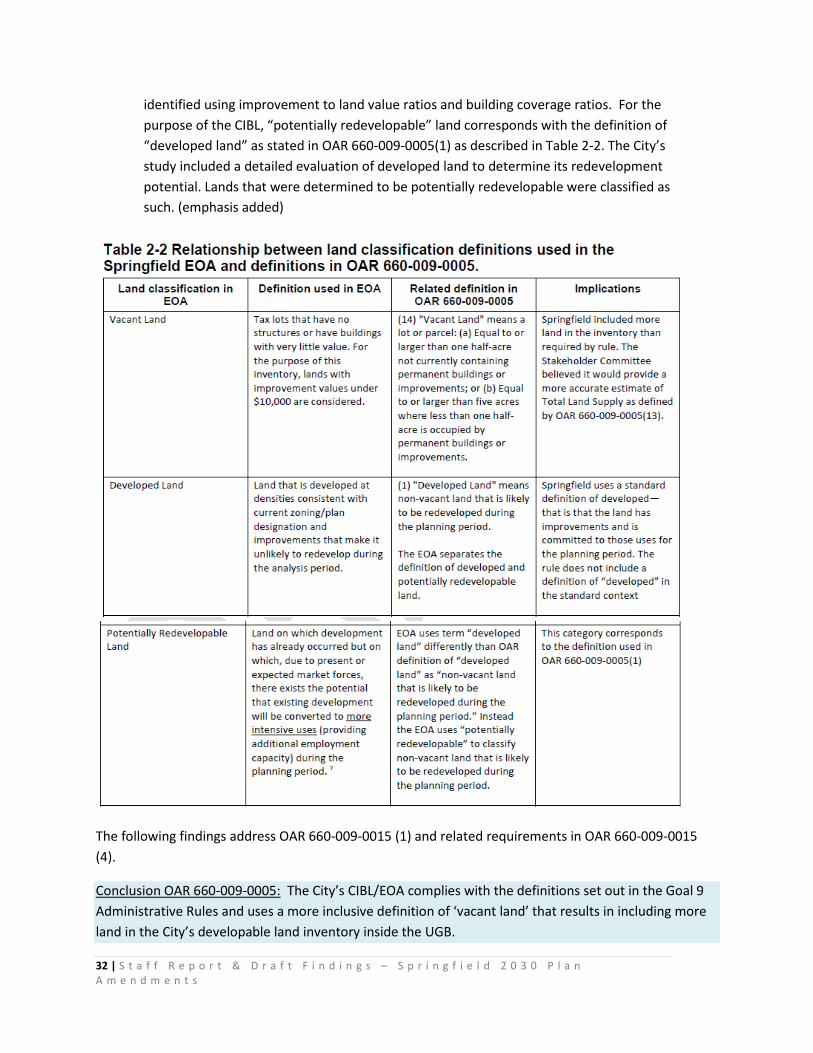
32 | S t a f f R e p o r t & D r a f t F i n d i n g s – S p r i n g f i e l d 2 0 3 0 P l a n A m e n d m e n t s
identified using improvement to land value ratios and building coverage ratios. For the purpose of the CIBL, “potentially redevelopable” land corresponds with the definition of “developed land” as stated in OAR 660-009-0005(1) as described in Table 2-2. The City’s study included a detailed evaluation of developed land to determine its redevelopment potential. Lands that were determined to be potentially redevelopable were classified as such. (emphasis added)
The following findings address OAR 660-009-0015 (1) and related requirements in OAR 660-009-0015 (4).
Conclusion OAR 660-009-0005: The City’s CIBL/EOA complies with the definitions set out in the Goal 9 Administrative Rules and uses a more inclusive definition of ‘vacant land’ that results in including more land in the City’s developable land inventory inside the UGB.

33 | S t a f f R e p o r t & D r a f t F i n d i n g s – S p r i n g f i e l d 2 0 3 0 P l a n A m e n d m e n t s
IVa. Economic Opportunities Analysis
OAR 660-009-0015 Economic Opportunities Analysis states:
“Cities and counties must review and, as necessary, amend their comprehensive plans to provide economic opportunities analyses containing the information described in sections (1) to (4) of this rule. This analysis will compare the demand for land for industrial and other employment uses to the existing supply of such land.”
The City’s amendment to the comprehensive plan to provide an Economic Opportunities Analysis must contain the four components listed in Sections 1-4 of OAR 660-009-0015:
• Review of National, State, Regional, County and Local Trends • Identification of Required Site Types • Inventory of Industrial and Other Employment Lands • Assessment of Community Economic Development Potential
CIBL/EOA Figure 4-1, p. 60 identifies how the required components of the City’s analysis are used to determine Springfield’s site needs:
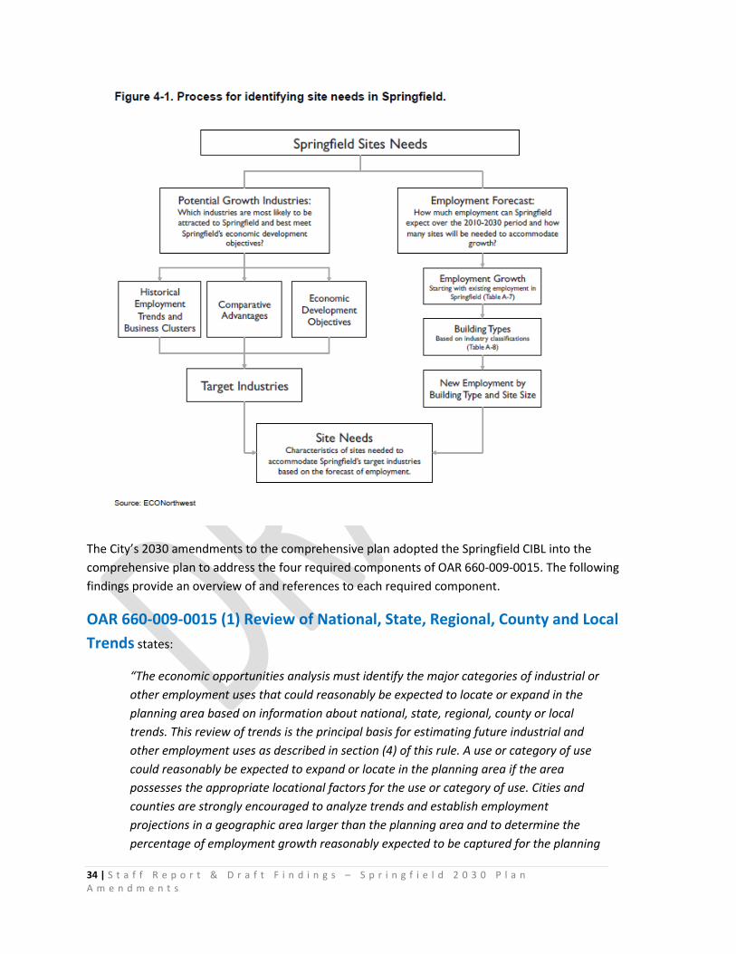
34 | S t a f f R e p o r t & D r a f t F i n d i n g s – S p r i n g f i e l d 2 0 3 0 P l a n A m e n d m e n t s
The City’s 2030 amendments to the comprehensive plan adopted the Springfield CIBL into the comprehensive plan to address the four required components of OAR 660-009-0015. The following findings provide an overview of and references to each required component.
OAR 660-009-0015 (1) Review of National, State, Regional, County and Local Trends states:
“The economic opportunities analysis must identify the major categories of industrial or other employment uses that could reasonably be expected to locate or expand in the planning area based on information about national, state, regional, county or local trends. This review of trends is the principal basis for estimating future industrial and other employment uses as described in section (4) of this rule. A use or category of use could reasonably be expected to expand or locate in the planning area if the area possesses the appropriate locational factors for the use or category of use. Cities and counties are strongly encouraged to analyze trends and establish employment projections in a geographic area larger than the planning area and to determine the percentage of employment growth reasonably expected to be captured for the planning
35 | S t a f f R e p o r t & D r a f t F i n d i n g s – S p r i n g f i e l d 2 0 3 0 P l a n A m e n d m e n t s
area based on the assessment of community economic development potential pursuant to section (4) of this rule.”
OAR 660-009-0015 (4) Assessment of Community Economic Development Potential states:
“The economic opportunities analysis must estimate the types and amounts of industrial and other employment uses likely to occur in the planning area. The estimate must be based on information generated in response to sections (1) to (3) of this rule and must consider the planning area's economic advantages and disadvantages. Relevant economic advantages and disadvantages to be considered may include but are not limited to:
(a) Location, size and buying power of markets;
(b) Availability of transportation facilities for access and freight mobility;
(c) Public facilities and public services;
(d) Labor market factors;
(e) Access to suppliers and utilities;
(f) Necessary support services;
(g) Limits on development due to federal and state environmental protection laws; and
(h) Educational and technical training programs.”
To address OAR 660-009-0015(1) and (4), the Springfield Economic Opportunities Analysis (EOA) uses the review of national, state, regional, county and local trends and assessment of community economic development potential “to estimate the types and amounts of industrial and other employment uses likely to occur in the planning area” in Chapter 3, Chapter 4, Appendix A and Appendix B. The “planning area” is defined in OAR 660-009-0005(7) as “the area within an existing or proposed urban growth boundary.” For this study, the planning area is land within the Springfield UGB and the proposed expansion of the Springfield UGB. “Locational factors for the use or category of use” are defined in OAR 660-009-0005(4): "Locational Factors" means market factors that affect where a particular type of industrial or other employment use will locate. Locational factors include, but are not limited to, proximity to raw materials, supplies, labor, services, markets, or educational institutions; access to transportation and freight facilities such as rail, marine ports and airports, multimodal freight or transshipment facilities, and major transportation routes; and workforce factors (e.g., skill level, education, age distribution).

36 | S t a f f R e p o r t & D r a f t F i n d i n g s – S p r i n g f i e l d 2 0 3 0 P l a n A m e n d m e n t s
The State forecasts that employment will continue growing in Lane County at 1.4% average annual growth, compared with the State average of 1.3% average annual growth. 32
Chapter 3 and appendices A and B of the CIBL/EOA (pp. 43-58) provide data to describe economic trends and locational factors affecting future growth in Springfield. OAR 660-009-0015(1) states: “A use or category of use could reasonably be expected to expand or locate in the planning area if the area possesses the appropriate locational factors for the use or category of use.” Chapter 3 describes availability of labor, changing population demographics, incomes, workforce, economic outlook, shifts in employment, outlook for growth, and regional business activity. The growing importance of the healthcare industry is noted, due to the location of two major healthcare centers (Sacred Heart RiverBend and McKenzie Willamette) in Springfield. The continued importance of manufacturing to provide desirable above-average wage jobs is noted, accounting for 10% of employment in Springfield.33
“Manufacturing is a traded sector industry, which brings revenue into Oregon and Lane County from outside the State. The following manufacturing industries accounted for two-thirds ($11 billion) of revenue from exports in Oregon in 2007: Computer & Electronic Production, Transportation Equipment, Machinery Manufacturers, Chemical Manufacture, and Primary Metal Manufacturers.34 These industries are all present in Lane County, accounting for 44% of manufacturing employment in the County.”35
Tourism is important in Springfield’s economy. A major source of tourism spending is overnight accommodations. Between 2000 and 2008, Springfield’s lodging tax revenue varied from $1.2 million in fiscal year 2004 to $1.6 million in fiscal year 2007. Springfield’s transient lodging tax revenues accounted for about one-quarter of total County lodging tax revenues. 36 Since the City’s CIBL/EOA was prepared, several new hotels have been built in Glenwood and Gateway, and more are in the planning stages in early 2016.
Locational Factors Influencing Springfield’s Comparative Advantages. Chapter 3 pp. 54-58 provides data describing Springfield’s comparative advantages for economic development: location, availability of transportation facilities and other public facilities, quality and availability of labor, and quality of life relative to these conditions in other portions of the Lane County and southern Oregon. Springfield’s primary comparative advantages are its location on Interstate Highway 5, proximity to Eugene, access to skilled labor, cost of labor, and high quality of life. These factors make Springfield attractive to residents and businesses that want a high quality of life where they live and work. As stated in the CIBL/EOA, factors that form Springfield’s comparative advantage are summarized below and described in detail in Appendix B:
32 CIBL/EOA, p. 70-71 33 In 2006 34 “Economic Data Packet, Mary 2008,” Oregon Economic And Community Development Department 35 CIBL/EOA, p. 53 36 Ibid
37 | S t a f f R e p o r t & D r a f t F i n d i n g s – S p r i n g f i e l d 2 0 3 0 P l a n A m e n d m e n t s
• “Location. Springfield is located in the Southern Willamette Valley, next to Eugene, between the Willamette River (to the south) and McKenzie River (to the north). Interstate 5 runs to the west of Springfield and Highway 126 runs east-west through Springfield. Springfield’s location, access to I-5 and Highway 126, and proximity to Eugene are primary comparative advantages for economic development in Springfield. These factors make Springfield attractive to businesses, especially those wanting to locate in the Willamette Valley.
• Buying Power of Markets. The buying power of Springfield and the Eugene-Springfield area forms part of Springfield’s comparative advantage by providing a market for goods and services. According to estimates on household spending by Claritas, households in Springfield are expected to spend about $937 million in 2008, about 14% of total household expenditures in the Eugene-Springfield Region. Springfield households spend an average of $42,700 on commonly purchased items, not including housing, Springfield’s households spent less than the regional and nation averages, with about 91% of the $47,000 average expenditures for all households in the Eugene-Springfield MSA and 84% of national average household expenditures (Claritas, 2008). The buying power of households in the Eugene-Springfield region provides Springfield with a comparative advantage. Access to households in the Eugene-Springfield Region provides businesses in Springfield with greater sales potential than other, smaller cities in the Southern Willamette Valley. As the population in Springfield (and the Eugene-Springfield region) grows, Springfield will need to provide more land for firms that provide services to residents and businesses.
• Transportation. Businesses and residents in Springfield have access to a variety of modes of transportation: automotive (Interstate 5, multiple State highways, and local roads); rail (Union Pacific and Amtrak); transit (LTD)37; and air (Eugene Airport). Springfield has excellent automotive access for commuting and freight movement. Springfield is located along Interstate 5, the primary north-south transportation corridor on the West Coast, linking Springfield to domestic markets in the United States and international markets via West Coast ports. Springfield has developed along Highway 126, Highway 126 is the primary east-west highway in Lane County, running from Florence to Redmond. Other transportation options in Springfield include: multiple Union Pacific rail lines provide freight service; transit service from the Lane Transit District provides bus service,
37 In 2016, the West Eugene EmX Bus Rapid Transit line is under construction. When complete, it will connect Springfield and Eugene residents to 56,000 jobs along the EmX line. https://www.ltd.org/latest-news/governor-brown-tours-eugene/
38 | S t a f f R e p o r t & D r a f t F i n d i n g s – S p r i n g f i e l d 2 0 3 0 P l a n A m e n d m e n t s
including Bus Rapid Transit, within Springfield and connects Springfield with Eugene; and the Eugene Airport provides both passenger and freight service. Springfield’s access to multiple modes of transportation provides Springfield with advantages in attracting businesses that need easy access to I-5 for automotive or some types of freight movement. Springfield may have disadvantages in attracting businesses that need large lots and easy access to I-5 because of the lack of buildable land along I-5 near Highway interchanges.
• Public Facilities and Services. The City has sufficient wastewater and water services to meet expected residential and employment needs. SUB has lower water rates than the national average. The combination of available and lower cost water may be an advantage to attracting some types of businesses to Springfield.
• Public Policy. The City can impact economic growth through its policies about the provision of land, redevelopment, and infill development. Success at attracting or retaining firms may depend on availability of attractive sites for development, especially large sites. For example, Springfield was attractive as a location of PeaceHealth’s new hospital because the City had a large, relatively flat site located relatively near to Interstate 5 and Beltline Highway. Springfield’s decision makers articulated their support for provision of employment land through the economic development strategy and in other policy choices. Objectives in the economic development strategy supporting the provision of employment land include objectives to: (1) provide employment land in a variety of locations, configurations, and site sizes for industrial and other employment uses, (2) provide an adequate competitive short-term supply of suitable land to respond to economic development opportunities as they arise, (3) reserve sites over 20-acres for special developments and industries that require large sites, and (4) provide adequate infrastructure to sites. The economic development strategy also includes objectives that support redevelopment of existing land within the UGB, especially in Downtown and in Glenwood, and infill development. The City is promoting redevelopment in Glenwood and Downtown through its administration of two Urban Renewal Districts.
• Labor Market. Commuting is common in Springfield. About 40% of the people who live in Springfield commute to Eugene for work. Less than one-third of Springfield’s workers live in Springfield. The implication of this workforce analysis is that, while only one-third of Springfield’s workforce lives within the City, Springfield is able to attract educated workers from most of Eugene and surrounding areas. Most people living or working in Springfield commute within the Eugene-Springfield area. This commuting pattern gives Springfield firms access to the workforce within the Eugene-Springfield region. Springfield residents generally have a shorter commute than residents of Lane County or Oregon. Eighty percent of Springfield residents commute 29 minutes or less, compared

39 | S t a f f R e p o r t & D r a f t F i n d i n g s – S p r i n g f i e l d 2 0 3 0 P l a n A m e n d m e n t s
to 77% of Lane County residents and 69% of Oregonians. 7% of Springfield’s residents are commuting 45 minutes or more, compared to 10% of Oregonians.38 The region’s existing and planned public transit system provides access to employment within the Eugene-Springfield Metro area. Springfield’s potential employment commute shed is extensive.39 Opportunities for workforce training and post-secondary education for residents of the Eugene-Springfield area include: the University of Oregon, Lane Community College, Northwest Christian College, and Gutenberg College.”
Appendix C of the CIBL/EOA (pp. 159-162) explains why and how Springfield’s comparative advantages are factors that may influence the locational decisions of firms.
“Key determinants of a location decision are a firm’s factors of production….In general, firms choose locations they believe will allow them to maximize net revenues: if demand for goods and services is held roughly constant, then revenue maximization is approximated by cost minimization.”
Production Factors. Table C-4, pp. 163-165 presents a summary of typical production factors and how these factors align with Springfield’s labor, land infrastructure, access to markets, materials, entrepreneurship, regulation, taxes, financial incentives, industry clusters, quality of life and innovative capacity. For example:
• “Labor. Based on existing commuting patterns, Springfield has access to labor from the Eugene-Springfield Region.
• Land. Demand for land depends on the type of firm. Manufacturing firms need more space and tend to prefer suburban locations where land is relatively less expensive and less difficult to develop. Warehousing and distribution firms need to locate close to interstate highways.
• Access to markets. Firms need to move their product, either goods or services, to the market, and they rely on access to different modes of transportation to do this. Springfield’s access to I-5 and Highway 126 provide the City with advantages in attracting businesses that need easy access to highways.
• Materials. Firms producing goods, and even firms producing services, need various materials to develop products that they can sell. Some firms need natural resources. For example, lumber manufacturing requires trees. Or, farther down the line, firms may need intermediate materials: for example, dimensioned lumber to build manufactured housing.
38 CIBL/EOA p. 48-49 39 Map: Industrial Competitiveness Criteria (prepared by LCOG staff for the City of Springfield) is a graphic depiction of a workforce of 250,000 living within a 40-mile radius of the I-105 interchange in Springfield —extending north to Corvallis, south to include Creswell and Cottage Grove, and southeast to include the communities of Lowell and Oakridge.

40 | S t a f f R e p o r t & D r a f t F i n d i n g s – S p r i n g f i e l d 2 0 3 0 P l a n A m e n d m e n t s
• Studies of economic development have shown that location decisions depend on a variety of other factors that indirectly affect costs of production. These indirect factors include agglomerative economies (also known industry clusters), quality of life, and innovative capacity.
o Industry clusters. Firms with similar business activities can realize operational savings when they congregate in a single location or region. Clustering can reduce costs by creating economies of scale for suppliers. For this reason, firms tend to locate in areas where there is already a presence of other firms engaged in similar or related activities.
o Quality of life. A community that features many quality amenities, such as access to recreational opportunities, culture, low crime, good schools, affordable housing, and a clean environment can attract people simply because it is a nice place to be. A region’s quality of life can attract skilled workers, and if the amenities lure enough potential workers to the region, the excess labor supply pushes their wages down so that firms in the region can find skilled labor for a relatively low cost. The characteristics of local communities can affect the distribution of economic development within a region, with different communities appealing to different types of workers and business owners. Sometimes location decisions by business owners are based on an emotional or historical attachment to a place or set of amenities, without much regard for the cost of other factors of production.
o Innovative capacity. Increasing evidence suggests that a culture promoting innovation, creativity, flexibility, and adaptability is essential to keeping U.S. cities economically vital and internationally competitive. Innovation is particularly important in industries that require an educated workforce. High-tech companies need to have access to new ideas typically associated with a university or research institute. Innovation affects both the overall level and type of economic development in a region. Government can be a key part of a community’s innovative culture, through the provision of services and regulation of development and business activities that are responsive to the changing needs of business.”40
The City’s CIBL/EOA presents an assessment of Springfield’s economic development potential based on the information generated in response to the Review of National, State, Regional, County and Local Trends; Identification of Required Site Types; and an Inventory of Industrial and Other Employment Lands. [OAR 660-009-0015(4)]
Chapter 4 of the CIBL/EOA (pp. 61- 72) identifies potential growth industries and key trends affecting employment growth in Springfield:
40 CIBL/EOA. P 159-165.
41 | S t a f f R e p o r t & D r a f t F i n d i n g s – S p r i n g f i e l d 2 0 3 0 P l a n A m e n d m e n t s
“One way to determine opportunities for economic development is to determine the sectors with the greatest expected growth in the region (based on the Oregon Employment Department’s forecast for employment growth in Lane County between 2006 and 2016) and the greatest concentration of existing employment in the community (based on a comparison of employment data in Springfield and the State in 2006). Sectors with high employment concentration in Springfield and high growth forecasts are the industries most likely to grow. These sectors in Springfield are: Health and Social Assistance; Administrative and Support and Waste Management Services; Construction; and Accommodations and Food Services.”
Springfield may have opportunities for growth in other sectors that the State forecasts will have high growth, such as: Arts, Entertainment, and Recreation; Management of Companies and Enterprises; Professional, Scientific, and Technical Services; and Private Educational Services.
Historical trends described in Springfield’s EOA include a shift away from manufacturing, a transition away from reliance on traditional resource-extraction industries, and growth of employment in high-technology manufacturing industries (Industrial Machinery, Electronic Equipment, and Instruments.)41
“Key historical trends between 1980 to 2007 period include:
• A substantial increase in the share of employment in Services, which increased from 23% to 42% of covered employment in Lane County.
• A decrease in the share of employment in Retail Trade, from 21% to 13%. The number of jobs in retail did not decrease substantially over the 27-year period (a loss of nearly 550 retail jobs) but growth in retail jobs lagged behind growth in other sectors, especially service sectors.
• A decline in the share of employment in Manufacturing, which fell from 20% to 13% of covered employment.
• A decline in the share of employment in Government, which decreased from 20% to 16% of covered employment.
• Other sectors of the County’s economy have a relatively stable and small share of the County’s employment.
• Historical employment trends show a substantial shift in the Region’s economy that mirrored shifts in the State and national economies, specifically the substantial growth in Services and decline of Manufacturing. While these trends are expected to continue into the future, future shifts are not expected to be as dramatic as those experienced over the past twenty years.”
41 CIBL/EOA, p. 49
42 | S t a f f R e p o r t & D r a f t F i n d i n g s – S p r i n g f i e l d 2 0 3 0 P l a n A m e n d m e n t s
The EOA explains why it is expected that the future employment mix will be somewhat different that the past:
• ”Growth in the Services sector has matured and should track more closely with overall employment and population growth rather than continuing to gain a substantial share of total employment.
• The decline in Manufacturing was due, in part, to decreased timber harvests and the outsourcing of production to facilities in countries with lower costs. Timber harvests are expected to level off and increase in the future as commercial forests that were replanted since the 1970s grow to a harvestable size. While outsourcing will continue, much of what can be outsourced has already gone. Remaining Manufacturing firms are tied to their region to be near supplies or markets, or manufacture specialized goods were small production quantities, fast turn-around times, and the need for quality limit the ability to outsource.”
• The mix of Manufacturing jobs in the Eugene-Springfield Region changed over the past twenty years with declines in Wood Products and the growth of employment in Recreational Vehicle (RV) manufacturing, machinery manufacturing, metals manufacturing, and high-tech industries, such as Computer and Electronics Manufacturing.”42
Major categories of industrial or other employment uses. EOA Chapter 4 pp. 61-75 identifies the major categories of industrial or other employment uses that could reasonably be expected to locate or expand in the Springfield planning area, based on the information about national, state, regional, county or local trends in Chapter 3 (pp. 43-58); and based on Springfield’s possession of the appropriate locational factors for the use or category of use as described in Chapter 3, pp. 54-58 “Springfield’s Comparative Advantages.”
Page 61-68 explain ECONorthwest’s methods and rationale for assessing business that are likely to have future growth in Springfield. ECO examined relative concentration and employment growth of existing business sectors, and relationships and linkages within industries. ECO reasoned that “sectors that are highly concentrated (meaning there are more than the “average” number of businesses in a sector in a given area) and have had high employment growth are likely to be successful industrial clusters. Sectors with either high concentration of businesses or high employment group may be part of an emerging cluster, with potential for future growth.”
Based on this analysis and verified by input received through the public involvement process,43 ECO and the City reasoned that the sectors with the most growth potential are: Health and Social Assistance; Administrative and Support; Construction; and Accommodations and Food Services. Other sectors with 42 CIBL/EOA pp. 49, 61-62 43 The CIBL Stakeholder Committee and CIBL Technical Advisory Committee processes are fully documented in the record and on the City’s website. CIBL/EOA Appendix D describes the public input the City received to identify Economic Development Objectives and Strategies and potential policies.
43 | S t a f f R e p o r t & D r a f t F i n d i n g s – S p r i n g f i e l d 2 0 3 0 P l a n A m e n d m e n t s
growth opportunities are: Arts, Entertainment, and Recreation; Management of Companies and Enterprises; Professional, Scientific, and Technical Services; and Private Educational Services.44
ECONorthwest’s methods and rationale for assessing business that are likely to have future growth in Springfield is reasonable and consistent with the law.
Existing and potential growth industries and business clusters. CIBL/EOA Table 4-1, Existing and potential growth industries and business clusters in Springfield identifies the following clusters: Medical Services, Manufacturing , Wood Products and Specialty Wood Products, Call Centers, Back-Office Functions, Tourism, High-tech (Software development, Computer electronics, Computer service providers, Data centers), and Biotech (Springfield has advantages in attracting Biotech firms because of the University of Oregon’s work in Biotech, presence of Invitrogen, and national growth in the industry.)
In Table 4-1, ECO identified existing45 and potential growth industries and business clusters in Springfield with employment potential and “secondary employment” businesses associated with each category. For example, “secondary employment” business growth associated with Springfield’s RiverBend Regional Medical Center and McKenzie Willamette Hospital Medical Services cluster include Medical Services and Suppliers, Research and Education, Medical equipment manufacturing, Non-medical office space, and services such as retail, restaurants, financial services, etc.
Types of manufacturing46 firms with potential growth in Springfield include:
• Food processing47 • High-tech electronics48 • Recreational Equipment • Medical Equipment manufacturing. • Furniture manufacturing • Specialty apparel • Cottage industries such as jewelry, apparel, or personal care products • Plastics manufacturing.
Associated businesses are manufacturing of related or complementary products, additional manufacturing, and services such as retail, restaurants, financial services, etc. 49
ECONorthwest’s methods and rationale for assessing existing and potential growth industries and business clusters in Springfield with employment potential and “secondary employment” businesses
44 CIBL/EOA p. 62-63 45 “Top Thirty Springfield Employers”, employment data, 2015 46 Information about the local/regional manufacturing: Livability Lane Cluster Analysis: Manufacturing Cluster Report, 2014. 47 Information about the local/regional Food & Beverage industry: Livability Lane Cluster Analysis: Food/Beverage Cluster Report, 2014; and “Doing Business in Oregon” 2012 Food processing. 48 Information about the local/regional tech industry is in the record: Livability Lane Cluster Analysis: EduTech Cluster Report, 2014. 49 Ibid.
44 | S t a f f R e p o r t & D r a f t F i n d i n g s – S p r i n g f i e l d 2 0 3 0 P l a n A m e n d m e n t s
associated with each category that are likely to have future growth in Springfield is reasonable and consistent with the law.
The EOA (p. 64) identifies “Target Industries” for Springfield, based on a range of factors:
• “Springfield’s existing employment base and the clusters of businesses in Springfield, such as those shown in Table 4-1, Table A-12, or Table A-7.
• Springfield’s comparative advantages, especially Springfield’s location in the Southern Willamette Valley next to Eugene, the easy access to Interstate 5 in Springfield, and the availability of educated and trained labor force from across the region.
• Local and regional economic trends, such as changes in regional employment (Table A-5), changes in regional business clusters, growth in tourism (Table A-13), growth in agriculture production (Table A-14), or forecasts for regional employment growth (Table A-16).
• National and statewide economic trends over the last three decades, such as growth in services or decline in wood products manufacturing.
• Local and regional demographic trends • Springfield’s economic development objectives, such as:
o Increasing employment in regional clusters, including: Health Care, Communication Equipment, Information Technology (Software), Metals (Wholesalers), Processed Food and Beverage, Wood & Forest Products, and Transportation Equipment.
o Recruiting businesses that pay higher than average wages for the region.”
ECO reasoned (with input from the public, CIBL Stakeholder Committee, Technical Advisory Committee, Planning Commission and City Council) that “the characteristics of Springfield will affect the types of businesses most likely to locate in Springfield. Springfield’s attributes that may attract firms are: the City’s proximity to I-5, high quality of life, proximity to the University of Oregon, the presence of the RiverBend campus, positive business climate, availability of skilled and semi-skilled labor, and proximity to indoor and outdoor recreational opportunities. The types of businesses that may be attractive to Springfield include medical services, services for seniors, manufacturing (small scale and large), specialty food processing, high-tech, professional and technical services, call centers, back office functions, tourism, green businesses, corporate headquarters, services for residents, and government and public services.”50
The uses or categories of use identified in the CIBL/EOA could reasonably be expected to expand or locate in the Springfield planning area because the Springfield area possesses the appropriate locational factors for the use or category of use.
50 CIBL/EOA pp. 64-68 list examples of each business type.
45 | S t a f f R e p o r t & D r a f t F i n d i n g s – S p r i n g f i e l d 2 0 3 0 P l a n A m e n d m e n t s
ECONorthwest’s methods and rationale for identifying target industries with employment potential for the 2010-2030 planning period in Springfield is reasonable, based on empirical evidence, responsive to public input, and consistent with the law.
Conclusions: OAR 660-009-0015(1) and (4).
As explained in the summary and findings above, the City’s CIBL/EOA identifies the major categories of industrial or other employment uses that could reasonably be expected to locate or expand in the Springfield planning area based on information about national, state, regional, county or local trends.
The CIBL/EOA uses the review of trends as the principal basis for estimating future industrial and other employment uses as described in section (4) of the rule.
The CIBL/EOA describes how Springfield possesses the appropriate locational factors for the use or category of uses that could reasonably be expected to expand or locate in the planning area.
The CIBL/EOA provides an analysis of trends affecting Springfield in the context of the region, county and state and Springfield’s comparative advantages to assess Springfield’s community economic development potential pursuant to section (4) of the rule.
Thus, the City’s Economic Opportunities Analysis meets the requirement of OAR 660-009-0015 (1) and (4).
The City’s 2030 Plan Amendments amend the comprehensive plan to provide an economic opportunities analysis containing the information described in OAR 660-009-0015 (1) and (4).
OAR 660-009-0015(2) Identification of Required Site Types.
“The economic opportunities analysis must identify the number of sites by type reasonably expected to be needed to accommodate the expected employment growth based on the site characteristics typical of expected uses. Cities and counties are encouraged to examine existing firms in the planning area to identify the types of sites that may be needed for expansion. Industrial or other employment uses with compatible site characteristics may be grouped together into common site categories.”
This section of Goal 9 rule requires the City’s analysis to determine the types, sizes and characteristics of sites of “typical of expected uses”, and to determine how many sites of each type are needed to accommodate the expected employment growth. The City is encouraged to base their decision about the types of sites needed by examining existing firms in the planning area.
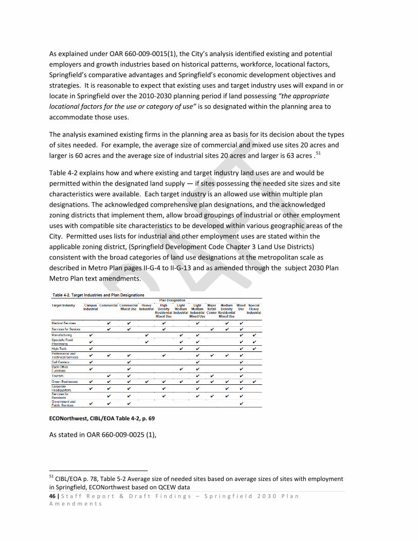
46 | S t a f f R e p o r t & D r a f t F i n d i n g s – S p r i n g f i e l d 2 0 3 0 P l a n A m e n d m e n t s
As explained under OAR 660-009-0015(1), the City’s analysis identified existing and potential employers and growth industries based on historical patterns, workforce, locational factors, Springfield’s comparative advantages and Springfield’s economic development objectives and strategies. It is reasonable to expect that existing uses and target industry uses will expand in or locate in Springfield over the 2010-2030 planning period if land possessing “the appropriate locational factors for the use or category of use” is so designated within the planning area to accommodate those uses.
The analysis examined existing firms in the planning area as basis for its decision about the types of sites needed. For example, the average size of commercial and mixed use sites 20 acres and larger is 60 acres and the average size of industrial sites 20 acres and larger is 63 acres .51
Table 4-2 explains how and where existing and target industry land uses are and would be permitted within the designated land supply — if sites possessing the needed site sizes and site characteristics were available. Each target industry is an allowed use within multiple plan designations. The acknowledged comprehensive plan designations, and the acknowledged zoning districts that implement them, allow broad groupings of industrial or other employment uses with compatible site characteristics to be developed within various geographic areas of the City. Permitted uses lists for industrial and other employment uses are stated within the applicable zoning district, (Springfield Development Code Chapter 3 Land Use Districts) consistent with the broad categories of land use designations at the metropolitan scale as described in Metro Plan pages II-G-4 to II-G-13 and as amended through the subject 2030 Plan Metro Plan text amendments.
ECONorthwest, CIBL/EOA Table 4-2, p. 69
As stated in OAR 660-009-0025 (1),
51 CIBL/EOA p. 78, Table 5-2 Average size of needed sites based on average sizes of sites with employment in Springfield, ECONorthwest based on QCEW data
47 | S t a f f R e p o r t & D r a f t F i n d i n g s – S p r i n g f i e l d 2 0 3 0 P l a n A m e n d m e n t s
“Plans do not need to provide a different type of site for each industrial or other employment use. Compatible uses with similar site characteristics may be combined into broad site categories. Several broad site categories will provide for industrial and other employment uses likely to occur in most planning areas. Cities and counties may also designate mixed-use zones to meet multiple needs in a given location.”
The City’s 2030 Plan amendments assume that future industrial or other employment uses will locate within lands inside the existing UGB that are designated as shown in Table 4-2 above, and on sites to be added to the UGB to accommodate the City’s deficit of sites larger than 5 acres. Appendix C explains how the employment forecast was converted to site needs by site size and type of building. It is reasonable to assume that industrial uses will primarily locate in industrial or campus industrial zones. Retail and service uses could locate in commercial zones, mixed use zones, and residential mixed-use zones.52
Employment Forecast. CIBL/EOA pages 70-72 and Appendix C explain the data sources and analytical methods used by the City’s consultant ECONorthwest (ECO) to determine the employment growth to be expected. On page 156, ECO explains that the safe harbor in OAR 660-024-0040(9)(a)(A) was used.53 CIBL/EOA page 70-72 presents a 2010-2030 projection of future employment levels in Springfield for the purpose of estimating demand for commercial and industrial land.
“The City’s intent was to adopt this EOA in 2010 and the City noticed DLCD of this intent on October 30, 2009.54 As a result, the employment forecast was developed in 2008 and is based on 2006 Quarterly Census of Employment and Wages (QCEW) data. Appendix C presents the process used to arrive at the employment forecast for Springfield. Table 4-3 shows that employment is forecast to grow by 13,440 employees (a 32% increase) between 2010 and 2030.”
As shown in Table 4-3, and as explained in Appendix C, pp. 155-156, the employment forecast for 2010-2030 shows employment growth of 13,440 total jobs.
52 CIBL/EOA p. 73 53 Springfield is part of Oregon Employment Department’s Region 5, which includes Lane County. 54 Springfield submitted notice to adopt Economic Opportunities Analysis policy amendments and a UGB amendment to DLCD on December 31st, 2009, with a first evidentiary hearing on February 17, 2010. This notice included the 2009 Economic Opportunities Analysis. The October notice to DLCD was in advance of an earlier hearing on the provisional Draft CIBL/EOA which was adopted by City Council Resolution.
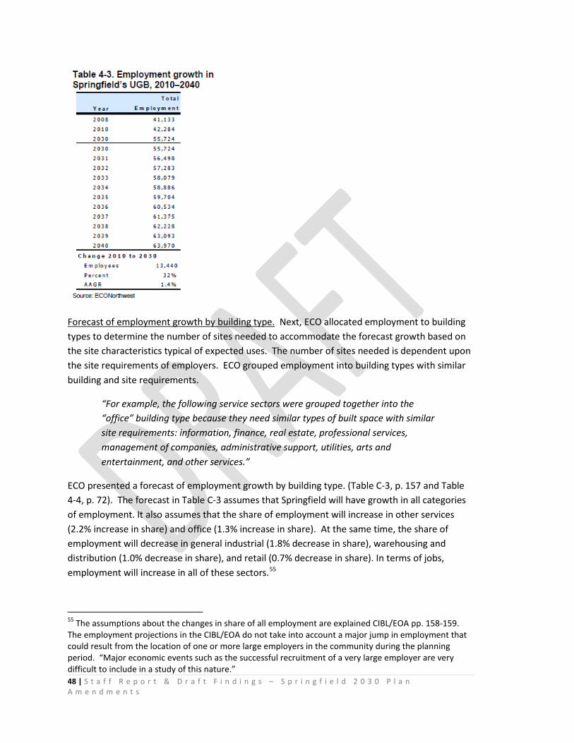
48 | S t a f f R e p o r t & D r a f t F i n d i n g s – S p r i n g f i e l d 2 0 3 0 P l a n A m e n d m e n t s
Forecast of employment growth by building type. Next, ECO allocated employment to building types to determine the number of sites needed to accommodate the forecast growth based on the site characteristics typical of expected uses. The number of sites needed is dependent upon the site requirements of employers. ECO grouped employment into building types with similar building and site requirements.
“For example, the following service sectors were grouped together into the “office” building type because they need similar types of built space with similar site requirements: information, finance, real estate, professional services, management of companies, administrative support, utilities, arts and entertainment, and other services.”
ECO presented a forecast of employment growth by building type. (Table C-3, p. 157 and Table 4-4, p. 72). The forecast in Table C-3 assumes that Springfield will have growth in all categories of employment. It also assumes that the share of employment will increase in other services (2.2% increase in share) and office (1.3% increase in share). At the same time, the share of employment will decrease in general industrial (1.8% decrease in share), warehousing and distribution (1.0% decrease in share), and retail (0.7% decrease in share). In terms of jobs, employment will increase in all of these sectors.55
55 The assumptions about the changes in share of all employment are explained CIBL/EOA pp. 158-159. The employment projections in the CIBL/EOA do not take into account a major jump in employment that could result from the location of one or more large employers in the community during the planning period. “Major economic events such as the successful recruitment of a very large employer are very difficult to include in a study of this nature.”
49 | S t a f f R e p o r t & D r a f t F i n d i n g s – S p r i n g f i e l d 2 0 3 0 P l a n A m e n d m e n t s
“For the purpose of the Springfield EOA, building types are used to relate employment by industry to site needs. The method used to describe site needs is to group industries based on building and site characteristics. This is consistent with how real estate markets work for urban development—demand for land is derived from demand for space. The type of building and industry is then related to land characteristics needed (e.g., site needs) to accommodate that industry. It is also consistent with OAR 660-009-0015(1) which states “Industrial or other employment uses with compatible site characteristics may be grouped together into common site categories. “ For this analysis, ECO relates industries by NAICS codes to building types which are used as a proxy for site needs. Each sector has been uniquely assigned to a “typical” building type, grouped by industrial and commercial uses.
Site needs and site characteristics typical of expected uses. Appendix C explains the process ECO used to convert employment forecast to site needs. The following section of this report explains how the EOA addressed OAR 660-009-0015(2): “site characteristics typical of expected uses.”
The tables in Appendix C provide data to document typical building and site needs of various industries.56 In addition to the evidence provided in the CIBL/EOA document, the record provides extensive supplemental evidence to explain the site needs of industries and the typical characteristics of sites that are necessary to support business operations and develop in accordance with applicable Federal, State and Local regulatory requirements.
Table C-5 “Characteristics of Sites Needed to Accommodate Employment Growth”57 presents and explains common site needs for expected industrial and other employment uses. Table C-5 summarizes 14 site attributes and explains how each attributes aligns with Springfield sites: flat site; parcel configuration and parking; soil type; road, rail, air, transit transportation; pedestrian and bicycle facilities; labor force; amenities; fiber optics and telephone; potable water; power requirements, and land use buffers.
Key points from Table C-5:
• “Large Industrial and Commercial firms that require on-site parking or truck access are attracted to sites that offer adequate flexibility in site circulation and building layout. Parking ratios of 0.5 to 2 spaces per 1,000 square feet for Industrial and 2 to 3 spaces per 1,000 square feet for Commercial are typical ratios for these firms. In general rectangular sites are preferred, with a parcel width of at least 200-feet and length that is at least two times the width for build-to-suit sites. Parcel width of at least 400 feet is desired for flexible industrial/business park developments and the largest Commercial users.
56 CIBL/EOA p. 71-72 57 CIBL/EOA. P. 167-169
50 | S t a f f R e p o r t & D r a f t F i n d i n g s – S p r i n g f i e l d 2 0 3 0 P l a n A m e n d m e n t s
• All firms are heavily dependent upon surface transportation for efficient movement of goods, customers, and workers. Access to an adequate highway and arterial roadway network is needed for all industries. Close proximity to a highway or arterial roadway is critical for firms that generate a large volume of truck or auto trips or for firms that rely on visibility from passing traffic to help generate business.
• Businesses in Springfield have access to I-5, Highway 126, Highway 99 (in Eugene), and Highway 58. The Gateway area is highly visible from I-5. Springfield also has a well-developed street network within the City. The City may need to work with large businesses to increase automotive capacity in newly developed areas or in areas where the intensity of employment uses increase substantially.
• Rail access can be very important to certain types of heavy industries. The region has good rail access to many industrial sites. Springfield is served by multiple Union Pacific rail lines. There are two primary junctions in Springfield: (1) the Springfield Junction is located in the Glenwood area in Southwest Springfield and (2) the Mohawk Junction is near the city’s southern boundary, near 25th St.
• Proximity to air transportation is important for some firms engaged in manufacturing, finance, or business services. Springfield is located 15 miles from the Eugene Airport.
• Transit access is important for Springfield’s target industries, especially those with many employees and customers and for businesses that employ and serve segments of the population without access to an automobile. Springfield has access to transit through the Lane Transit District (LTD). There are multiple bus lines that run throughout Springfield and multiple buses that connect Springfield and Eugene. The first two lines of the EmX bus rapid transit system have been completed and serve existing employment nodes in Glenwood, Downtown and RiverBend/Gateway. Additional Frequent Transit Network (FTN) routes are identified in the Regional Transportation Plan. In 2016, The Main Street Corridor FTN route is being planned.
• The ability for workers to access amenities and support services such as shopping, entertainment and recreation areas by foot or bike is increasingly important to employers, particularly those with high-wage professional jobs. The need for safe and efficient bicycle and pedestrian networks will prove their importance over time as support services and neighborhoods are developed adjacent to employment centers. Springfield has pedestrian and bicycle facilities.
51 | S t a f f R e p o r t & D r a f t F i n d i n g s – S p r i n g f i e l d 2 0 3 0 P l a n A m e n d m e n t s
Springfield last updated the City Bicycle Plan in 1998. The plan proposes expansion of bicycle facilities to improve bicycle connectivity throughout the City and to neighboring communities. People in Springfield are able to use bicycle facilities for commuting if they live and work in areas of the City that have bicycle infrastructure. Commuting via pedestrian facilities may be more limited to people who live near their work. Springfield’s pedestrian and bicycle facilities can be used on conjunction with LTD buses to provide opportunities for alternative methods of commuting for people that live further from work.
• According to the International Economic Development Council,58 attracting and retaining skilled workers requires that firms seek out places offering a high quality of life that is vibrant and exciting for a wide range of people and lifestyles. Springfield offers access to outdoor amenities and an excellent parks and recreation district (Willamalane). Many urban amenities are available in Springfield and Eugene.
• Most, if not all industries expect access to multiple phone lines, a full range of telecommunication services, and high-speed internet communications. Springfield has access to high-speed telecommunications facilities.
• Potable water needs range from domestic levels to 1,000,000 gallons or more per day for some manufacturing firms. However, emerging technologies are allowing manufacturers to rely on recycled water with limited on-site water storage and filter treatment. The demand for water for fire suppression also varies widely. Springfield has sufficient potable water to meet current and expected needs.
• Electricity power requirements range from redundant (uninterrupted, multi-sourced supply) 115 kva to 230 kva. Average daily power demand (as measured in kilowatt hours) generally ranges from approximately 5,000 kwh for small business service operations to 30,000 kwh for very large manufacturing operations. The highest power requirements are associated with manufacturing firms, particularly fabricated metal and electronics. For comparison, the typical household requires 2,500 kwh per day. Springfield has access to sufficient power supply to accommodate most commercial and industrial users.
58 International Economic Development Council. “Economic Development Reference Guide,” http://www.iedconline.org/hotlinks/SiteSel.html. 10/25/02.
52 | S t a f f R e p o r t & D r a f t F i n d i n g s – S p r i n g f i e l d 2 0 3 0 P l a n A m e n d m e n t s
• According to the public officials and developers/brokers ECO has interviewed, industrial areas have operational characteristics that do not blend as well with residential land uses as they do with Office and Commercial areas. Generally, as the function of industrial use intensifies (e.g., heavy manufacturing) so too does the importance of buffering to mitigate impacts of noise, odors, traffic, and 24-hour 7-day week operations. Adequate buffers may consist of vegetation, landscaped swales, roadways, and public use parks/recreation areas. Depending upon the industrial use and site topography, site buffers range from approximately 50 to 100 feet. Selected commercial office, retail, lodging and mixed use (e.g., apartments or office over retail) activities are becoming acceptable adjacent uses to some light industrial areas. Springfield’s employment sites are generally located in areas where employment is compatible with other development. In areas where employment is not directly compatible with adjacent uses, the City may require buffers between incompatible uses.”
Site needs data. CIBL/EOA Table C-6 through Table C-11 present data from a range of sources describing site needs attributes of businesses that either considered locating in Oregon (including in the Eugene-Springfield area) or are industries within one or more of Springfield’s target growth sectors or clusters. These examples are presented in the CIBL/EOA to illustrate that businesses have a wide range of need for site size, location, and characteristics based on the business’s individual operational needs. “The site needs of businesses vary from business to business, even within the same industry. As a result, one business’s site needs may be different and potentially even conflicting with another business’s site needs.”59
Long term and short term site needs are estimated in CIBL/EOA pp. 72-75:
• “Types of needed sites are based on the site characteristics typical of expected uses.”
• “The Goal 9 rule provides flexibility in how jurisdictions conduct and organize this analysis. For example, site types can be described by plan designation (i.e., heavy or light industrial), they can be by general size categories that are defined locally (i.e., small, medium, or large sites), or it can be industry or use-based (i.e., manufacturing sites or distribution sites).”
• “Firms wanting to expand or locate in Springfield will be looking for a variety of site and building characteristics, depending on the industry and specific circumstances. Previous research conducted by ECO has found that while there
59 CIBL/EOA, p. 170-178. The record provides additional evidence to describe the characteristics of sites needed to accommodate industrial and other employment growth target industries, including industries that require sites 20-acres and larger.
53 | S t a f f R e p o r t & D r a f t F i n d i n g s – S p r i n g f i e l d 2 0 3 0 P l a n A m e n d m e n t s
are always specific criteria that are industry-dependent and specific firm, many firms share at least a few common site criteria. In general, all firms need sites that are relatively flat, free of natural or regulatory constraints on development, with good transportation access and adequate public services. The exact amount, quality, and relative importance of these factors vary among different types of firms. This section discusses the site requirements for firms in industries with growth potential in the Eugene-Springfield Region, as indicated by the Oregon Employment Department forecast (see Table A-12 in Appendix A for the regional forecast).”
Conclusions: OAR 660-009-0015(2). The CIBL/EOA Appendix C presents a detailed analysis of Springfield’s site needs and site characteristics consistent with OAR 660-009-0015(2) and OAR 660-009-0025(1).
The CIBL/EOA, Appendix C and the record provide ample evidence explaining how the City’s examination of existing firms in the planning area was used to identify the types of sites that may be needed for expansion.
The City’s analysis grouped Industrial or other employment uses with compatible site characteristics into common site categories.
Appendix C discusses the factors that affect business’ locational decisions and how these factors influence the decisions of businesses that may choose to expand or locate in Springfield. Appendix C describes and explains the characteristics of sites needed to accommodate employment growth and Springfield’s ability to provide sites possessing those characteristics.
The City’s CIBL/EOA provides identification of required site types based on the site characteristics typical of expected uses (CIBL/EOA pp. 82-95, and Appendix C).
The City’s CIBL/EOA provides identification of required site types consistent with the requirements of OAR 660-009-0015(2).
The City’s 2030 Plan Amendments amend the comprehensive plan to provide an economic opportunities analysis containing the information described in OAR 660-009-0015(2).
OAR 660-009-0015(3) Inventory of Industrial and Other Employment Lands states:
“Comprehensive plans for all areas within urban growth boundaries must include an inventory of vacant and developed lands within the planning area designated for industrial or other employment use.
(a) For sites inventoried under this section, plans must provide the following information:
54 | S t a f f R e p o r t & D r a f t F i n d i n g s – S p r i n g f i e l d 2 0 3 0 P l a n A m e n d m e n t s
(A) The description, including site characteristics, of vacant or developed sites within each plan or zoning district;
(B) A description of any development constraints or infrastructure needs that affect the buildable area of sites in the inventory; and
(C) For cities and counties within a Metropolitan Planning Organization, the inventory must also include the approximate total acreage and percentage of sites within each plan or zoning district that comprise the short-term supply of land.
(b) When comparing current land supply to the projected demand, cities and counties may inventory contiguous lots or parcels together that are within a discrete plan or zoning district.
(c) Cities and counties that adopt objectives or policies providing for prime industrial land pursuant to OAR 660-009-0020(6) and 660-009-0025(8) must identify and inventory any vacant or developed prime industrial land according to section (3)(a) of this rule.”
CIBL Inventory of Vacant and Potentially Redevelopable Land. The City’s 2030 Plan Amendments to the Metro Plan include an inventory of vacant and developed lands within the planning area designated for industrial or other employment use. Springfield commissioned ECONorthwest in 2008 to conduct the inventory and to prepare the necessary factual base for the Plan. CIBL/EOA Chapter 2 Land Available for Industrial and Other Employment Uses, pp. 5-41 presents the inventory.
As explained on page 5, ECONorthwest used the best available or readily collectable information: GIS data provided by the City Technical Services Division and Lane Council of Governments, aerial orthophotographs, and verification by City staff. ECO worked closely ECO worked closely with City Staff, a Technical Advisory Committee, and a Stakeholder Committee during the development and review of the Springfield commercial and industrial buildable lands inventory (CIBL). ECO developed the inventory using the following steps:
• Assemble and document datasets. ECO identified data from the Regional Land Information Database (RLID) and GIS data from the City of Springfield and the Lane Council of Governments as primary datasets on which the inventory and analysis was built. RLID includes assessment and taxation data maintained by Lane County.
• Preliminary analysis. ECO conducted a preliminary analysis with the GIS and data tables selected for inclusion in the database. The purpose of this task was to work with City staff and the TAC to determine the optimal definitions and supporting methodology to base the final analysis and database structure.
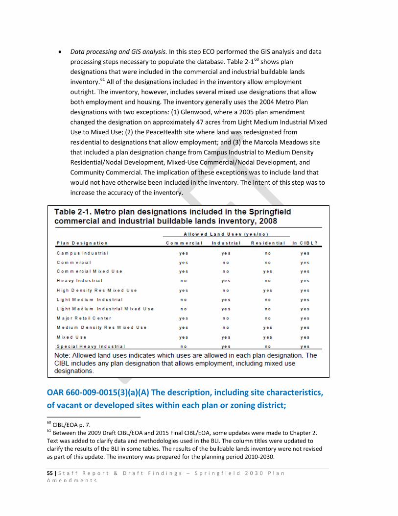
55 | S t a f f R e p o r t & D r a f t F i n d i n g s – S p r i n g f i e l d 2 0 3 0 P l a n A m e n d m e n t s
• Data processing and GIS analysis. In this step ECO performed the GIS analysis and data processing steps necessary to populate the database. Table 2-160 shows plan designations that were included in the commercial and industrial buildable lands inventory.61 All of the designations included in the inventory allow employment outright. The inventory, however, includes several mixed use designations that allow both employment and housing. The inventory generally uses the 2004 Metro Plan designations with two exceptions: (1) Glenwood, where a 2005 plan amendment changed the designation on approximately 47 acres from Light Medium Industrial Mixed Use to Mixed Use; (2) the PeaceHealth site where land was redesignated from residential to designations that allow employment; and (3) the Marcola Meadows site that included a plan designation change from Campus Industrial to Medium Density Residential/Nodal Development, Mixed-Use Commercial/Nodal Development, and Community Commercial. The implication of these exceptions was to include land that would not have otherwise been included in the inventory. The intent of this step was to increase the accuracy of the inventory.
OAR 660-009-0015(3)(a)(A) The description, including site characteristics, of vacant or developed sites within each plan or zoning district; 60 CIBL/EOA p. 7. 61 Between the 2009 Draft CIBL/EOA and 2015 Final CIBL/EOA, some updates were made to Chapter 2. Text was added to clarify data and methodologies used in the BLI. The column titles were updated to clarify the results of the BLI in some tables. The results of the buildable lands inventory were not revised as part of this update. The inventory was prepared for the planning period 2010-2030.
56 | S t a f f R e p o r t & D r a f t F i n d i n g s – S p r i n g f i e l d 2 0 3 0 P l a n A m e n d m e n t s
Metro Plan Chapter II, pages II-G-4 through II-G-12, as amended by the City’s subject proposal, provides general descriptions and site characteristics of vacant or developed sites within the land use districts that provide sites for industrial and other employment uses. Seven acknowledged neighborhood refinement plans (Downtown, Gateway, Glenwood, Kelly Butte, East Main, Q Street, and Mid Springfield) and approved Master Plans provide more refined descriptions and site characteristics of vacant or developed sites within the land use districts that provide sites planned and zoned for industrial and other employment uses. The Springfield Development Code Chapter 3 provides descriptions and site characteristics of the land use districts that provide sites for industrial and other employment uses. Characteristics addressed include required sizes of plan districts, parcel sizes, minimum development areas, use categories, operational performance standards.62
The City’s development regulations in Springfield Development Code Chapter 4 implement Metro Plan policies, State and Federal law and thus are germane to any discussion of site characteristics. [OAR 660-009-0015(3)(a) A and B].63 The policies of the comprehensive plan, as implemented through the City’s development standards in SDC Chapter 3 and 4 provide descriptions of land planned and zoned for employment uses, including physical and operational requirements that influence the development area size and configuration needed to operate a use and the placement of development on a site in relationship to public rights of way and abutting land uses.
The City’s land use approvals of the RiverBend and Marcola Meadows Master Plans impose additional standards and requirements pertaining to development of employment uses within those areas. Both Master Plans describe land planned and zoned for employment uses and address physical and operational requirements that influence the development area size and configuration needed to operate a use and the placement of development on a site in relationship to public rights of way and abutting land uses.
Springfield’s existing acknowledged comprehensive plan and land use regulations identify lands planned and zoned for continued and increased economic growth and activity.
The City’s inventory provides the description, including site characteristics, of vacant or developed sites within each plan or zoning district [OAR 660-009-0015(3)(a)(A).
CIBL/ EOA Chapter 2, (pp. 5-41) provides explanation of the systematic process ECO employed to complete Springfield’s inventory. Pages 8-12 provide explanation of how ECO classified each tax lots as “vacant”, ”developed” or “potentially redevelopable.” The City’s definition of vacant
62 For example, SDC 3.2 -420 and 425 Springfield’s Campus Industrial Zoning District standards regulate minimum parcel sizes, frontages, lot coverage, setbacks, parking, driveway and outdoor storage, landscaped buffers, movement of heavy equipment, storage of materials, air pollution controls, reduction of glare from lighting, groundwater protection, hazardous waste, noise, radiation and vibration. 63 For example, SDC 4.1-100 regulates street width, block length, site access and driveways, intersections, vision clearances, sidewalks, street trees, bikeways, and accessways. SDC 4.3-110 to 117 regulates on-site stormwater management, water quality and natural resource protection.
57 | S t a f f R e p o r t & D r a f t F i n d i n g s – S p r i n g f i e l d 2 0 3 0 P l a n A m e n d m e n t s
land is more inclusive than what statewide planning policy requires. The implication of using a more inclusive definition are that more land was considered available in the inventory than would be if the state definitions were used.
CIBL/ EOA Map 2-164 presents the Metro plan designations used in for inventory purposes.
As shown in CIBL/EOA Map 2-1 Existing Plan Designations, Springfield’s previously-designated existing land base will provide sites for commercial and industrial land uses over the planning period, on vacant land, and on land where redevelopment is expected to occur.
OAR 660-009-0015 (3)(a)(B) description of any development constraints or infrastructure needs that affect the buildable area of sites in the inventory
Development constraints applied in the Springfield CIBL/EOA. OAR 660-009-0015 (3)(a)(B) requires the inventory to provide “A description of any development constraints or infrastructure needs that affect the buildable area of sites in the inventory.” CIBL/EOA pp. 14-16 presents a description of development constraints or infrastructure needs that affect the buildable area of sites in Springfield’s inventory.
Development constraints are defined in OAR 660-009-0005(2):
"Development Constraints" means factors that temporarily or permanently limit or prevent the use of land for economic development. Development constraints include, but are not limited to, wetlands, environmentally sensitive areas such as habitat, environmental contamination, slope, topography, cultural and archeological resources, infrastructure deficiencies, parcel fragmentation, or natural hazard areas.”
The rule leaves discretion for local governments in the application of the definition.
“For the purpose of this CIBL/EOA, the following factors are considered “absolute development constraints” which make employment land unsuitable for development:65
• Wetlands – Source: City of Springfield Local Wetland Inventory. File used: wet_lwi.shp, accessed 2008
• Floodway – Source: Army Corps of Engineers digital “FIRM” maps. File used: fld_way.shp, accessed 2008
• Slopes over 15% - Source: 10 meter digital elevation model (DEM). File used: slopes_over_15.shp, accessed 2008
64 CIBL/EOA, p. 13. 65 Each of these files was provided to ECONorthwest by the City in 2008.
58 | S t a f f R e p o r t & D r a f t F i n d i n g s – S p r i n g f i e l d 2 0 3 0 P l a n A m e n d m e n t s
• Riparian resource areas – Source: City of Springfield. File used: Riparian_resource_areas.shp, accessed 2008
The following factors were assumed “partial development constraints” in the CIBL/EOA. Partial constraints are factors that may create difficulties in development, but do not preclude development. Partial constraints were not deducted from the inventory. Land with these constraints is classified as “constrained” on employment land. Development can occur on “constrained” land and no deductions were made from the inventory for these factors.66
• Floodplain – Source: Army Corps of Engineers digital “FIRM” maps. File used: lane_dfirm.shp, accessed 2008
• Willamette River Greenway – Source: Lane Council of Governments. File used: Greenway_10m_20080303.shp, accessed 2008
• BPA Easements – Source: Bonneville Power Administration. File used: bparow_lane.shp, accessed 2008”
ECONorthwest used a systematic process to prepare Springfield’s Commercial and Industrial land inventory.
“Processing and analyzing data from the Lane Council of Governments (LCOG) land use database (a database that inventories land uses at the sub-tax lot level), ECONorthwest identified the developed or unsuitable portions of tax lots. Areas of partially vacant tax lots with development were included in the “developed acres” category and remainders were considered “suitable”67 (unless they had absolute constraints). The inventory also deducted the “absolute constraints” that make land unsuitable for employment uses. Each of these constraints was available in a GIS format. The four absolute constraints layers were “dissolved” together to create a single “absolute” constrained layer. This was done to avoid double counting since some constraints (e.g., floodways and wetlands) occur in the same place. The combined constraints layer was then used to calculate the portion of the lot that was constrained and therefore unsuitable for development.”68
The land base for the inventory the inventory is presented on pp. 17-19 and Map 2-3.
“Vacant” and “potentially redevelopable” land is identified in pp. 21-23 and Maps 2-3, 2-4 and 2-5, pp. 24-26.
As shown in CIBL/EOA Map 2-3 Vacant Commercial and Industrial Land, and CIBL/EOA pp. 21-26, portions of this land base are vacant. The City’s definition of “vacant” is stated on CIBL/EOA p.
66 Each of these files was provided to ECONorthwest by the City in 2008. 67 OAR 660-009-0005(12) defines “suitable” land as “serviceable land designated for industrial or other employment use that provides, or can be expected to provide the appropriate site characteristics for the proposed use.” 68 CIBL/EOA pp. 11-12
59 | S t a f f R e p o r t & D r a f t F i n d i n g s – S p r i n g f i e l d 2 0 3 0 P l a n A m e n d m e n t s
9. Springfield’s inventory included more land in the inventory that required by rule. Lands with improvement values under $10,000 were considered vacant.
Springfield’s inventory also identified “potentially redevelopable” land where there exists the potential that existing development will be converted to more intensive uses providing more employment capacity during the planning period. This category is discussed on CIBL/EOA p. 9 and 11-12, 21, 27-38, and Map 2-6, p. 32. The CIBL/EOA also includes a parcel–level evaluation of potentially redevelopable sites 5 acres and larger on pp. 33-38.
The City’s CIBL inventory of Industrial and Other Employment Lands explains the capacity of vacant, developed and potentially redevelopable sites to meet site needs for the planning period.
The inventory indicates that Springfield has a deficit of suitable sites that are 20 acres and larger, and deficit of sites 5-20 acres in size. After assuming that all site needs for commercial and industrial uses that require sites smaller than 5 acres would be addressed through redevelopment, CIBL/EOA Table 5-4, (p. 80) shows a deficit of 2 industrial sites and 1 commercial and mixed use site 20 acres and larger. Table 5-2 (p. 78) shows the average site size in Springfield for industrial and commercial and mixed use sites 20 acres and larger: 63 acres and 60 acres respectively. Thus Springfield has a need for 126 acres of industrial employment land on 2 sites larger than 20 acres and a need for 97 acres of commercial employment land on 5 sites, including one site that is 60 acres in size.
The City and Lane County amended the Springfield UGB to provide 223 acres of employment land to meet employment land needs that require sites larger than 5 acres.
Conclusions OAR 660-009-0015(3): As amended through the City’s 2030 Plan amendments, the comprehensive plan for areas within Springfield’s urban growth boundary includes an inventory of vacant and developed lands within the planning area designated for industrial or other employment use that provides the information required in OAR 660-009-0015(3)(a),(b) and (c) because the plan includes a description of the land, development constraints and the approximate total acreage of the sites that comprise the short-term supply of land.
OAR 660-009-0015(3)(a)(C): Short-term supply of land
“For cities and counties within a Metropolitan Planning Organization, the inventory must also include the approximate total acreage and percentage of sites within each plan or zoning district that comprise the short-term supply of land.”
The CIBL/EOA pp. 39-41 addresses the requirement for cities within MPOs to make commitments to provide competitive short-term supplies of land. The CIBL/EOA provides an assessment of Springfield’s short-term land supply. With the exception of the southern extent of the Jasper-Natron area, all commercial and industrial lands within the existing UGB can be

60 | S t a f f R e p o r t & D r a f t F i n d i n g s – S p r i n g f i e l d 2 0 3 0 P l a n A m e n d m e n t s
considered to technically meet the Goal 9 rule criteria of “engineering feasibility.” [OAR 660-009-0020(1)(b), OAR 660-009-0025]. Thus more than 91% of the vacant commercial and industrial land is considered available as short term supply, and more the 85%.
The CIBL/EOA includes the approximate total acreage and percentage of sites within each plan or zoning district that comprise the short-term supply of land. [OAR 660-009-0015(3)(a)(C)]
OAR 660-009-0015(3)(a)(C)(c) vacant or developed prime industrial land
“Cities and counties that adopt objectives or policies providing for prime industrial land pursuant to OAR 660-009-0020(6) and 660-009-0025(8) must identify and inventory any vacant or developed prime industrial land according to section (3)(a) of this rule.”
OAR 660-009-0020(6)/OAR 660-009-0025(8) special siting characteristics The City’s CIBL/EOA identifies a need for suitable employment land to accommodate uses with “special siting characteristics,”69 thus OAR 660-009-0025(8) and OAR 660-009-0015(3)(a)(C)(c) are applicable. As amended through the City’s 2030 Plan amendments, the comprehensive plan for areas within Springfield’s urban growth boundary includes an inventory of vacant and developed lands within the planning area designated for industrial or other employment use that provides the information required in OAR 660-009-0015(3)(a). The City’s CIBL inventory of Industrial and Other Employment Lands explains the capacity of vacant, developed and potentially redevelopable sites to meet site needs for the planning period. The inventory indicates that Springfield has a deficit of suitable sites that are 20 acres and larger, and deficit of sites 5-20 acres in size. After assuming that all site needs for commercial and industrial uses that require sites smaller than 5 acres would be addressed through redevelopment70, CIBL/EOA Table 5-4, (p. 80) shows a deficit of 2 industrial sites and 1 commercial and mixed use site 20 acres and larger. Table 5-2 (p. 78) shows the average site size in Springfield for industrial and commercial and mixed use sites 20 acres and larger: 63 acres and 60 acres respectively. Thus Springfield has a need for 126 acres of industrial employment land on 2 sites larger than 20 acres and a need for 97 acres of commercial employment land on 5 sites, including one site that is 60 acres in size. The City and Lane County amended the Springfield UGB to provide 223 acres of employment land to meet employment land needs that require sites larger than 5 acres.
69 CIBL/EOA pp. 82-98 identifies target large-scale manufacturers and large office employers that require sites with special characteristics including : site size 20 acres and larger, topography less 5 % / 7%, transportation access as close to I-5 as possible via unimpeded freight route, access to public facilities and services, and sites with two or fewer owners. 70 CIBL/EOA Table 5-1, p. 78 shows that 188 industrial sites and 340 commercial and mixed use sites would redevelop to address land needs over the 20-year period. In addition to this assumption, Springfield concludes that all land needs on sites smaller than 5 acres would be accommodated through redevelopment, including the 6-acre deficit of 2-5 acre sites shown in Table 5-3, p. 79.

61 | S t a f f R e p o r t & D r a f t F i n d i n g s – S p r i n g f i e l d 2 0 3 0 P l a n A m e n d m e n t s
The City and Lane County adopted policies in the 2030 Comprehensive Plan Urbanization Element and land use regulations in the Springfield Development Code71 to protect sites 20 acres and larger from land division in order to accommodate uses that require sites 20 acres and larger.
Conclusion OAR 660-009-0015(3): The CIBL/EOA provides an inventory of industrial and other employment lands consistent with all applicable requirements of the rule.
OAR 660-009-0015(4) Assessment of Community Economic Development Potential
“The economic opportunities analysis must estimate the types and amounts of industrial and other employment uses likely to occur in the planning area. The estimate must be based on information generated in response to sections (1) to (3) of this rule and must consider the planning area's economic advantages and disadvantages. Relevant economic advantages and disadvantages to be considered may include but are not limited to:
(a) Location, size and buying power of markets;
(b) Availability of transportation facilities for access and freight mobility;
(c) Public facilities and public services;
(d) Labor market factors;
(e) Access to suppliers and utilities;
(f) Necessary support services;
(g) Limits on development due to federal and state environmental protection laws; and
(h) Educational and technical training programs.”
As previously discussed in pp. 31-38 of this report, the CIBL/EOA estimated the types and amounts of industrial and other employment uses likely to occur in the planning area based on information generated in response to sections (1) to (3) of the Goal 9 rule and in consideration of the Springfield planning area's economic advantages and disadvantages. The CIBL/EOA provides assessment of relevant economic advantages and disadvantages including but are not limited to factors (a)-(h) in the CIBL/EOA Chapter 3 and 4, pp. 43-68.
Conclusion OAR 660-009-0015(4). The City’s CIBL/EOA provides the required assessment of community economic development potential because it specifically considers several of the
71 See Ordinance _____, Exhibit E: SDC 3.2-900 Agriculture- Urban Holding Area (AG) Zoning District
62 | S t a f f R e p o r t & D r a f t F i n d i n g s – S p r i n g f i e l d 2 0 3 0 P l a n A m e n d m e n t s
factors as suggested by the rule such as location, buying power of markets, transportation and public facilities.
OAR 660-009-0015(5) public and state agency involvement to inform community economic development objectives
“Cities and counties are strongly encouraged to assess community economic development potential through a visioning or some other public input based process in conjunction with state agencies. Cities and counties are strongly encouraged to use the assessment of community economic development potential to form the community economic development objectives pursuant to OAR 660-009-0020(1)(a).
As explained in CIBL/EOA Appendix D, Economic Development Objectives and Implementation Strategies72, the City conducted a visioning process to assess community economic development potential. State economic development agency staff Bob Warren and local DLCD representative Ed Moore participated on the CIBL Technical Advisory Committee. The Committee provided input and advice to the City’s consultant ECONorthwest to develop a survey and two visioning workshops73 to inform preparation of the CIBL/EOA and Economic Development Objectives and Implementation Strategies. As explained in CIBL/EOA Appendix D, the assessment of community economic development potential was used to form the community economic development objectives pursuant to OAR 660-009-0020(1)(a). Input received through the visioning was used to draft potential economic development policies and actions that ultimately were incorporated into the Springfield Comprehensive Plan Economic Element and Urbanization Element policies to address OAR 6660-009-0020.
Conclusion OAR 660-009-0015(5). The City assessed community economic development potential through visioning and other public input processes in conjunction with state agencies. For example, the City obtained guidance and input from citizen stakeholder and technical advisory committees and used the assessment to form the economic development objectives in the CIBL/EOA and as foundation for developing comprehensive plan goals, policies and strategies in the Economic Element.
72 The local record contains complete documentation of the survey conducted April 4-May 27, 2008 and workshops. 73 Community workshops conducted May 20, 2008 and July 31, 2008

63 | S t a f f R e p o r t & D r a f t F i n d i n g s – S p r i n g f i e l d 2 0 3 0 P l a n A m e n d m e n t s
IVb. Industrial and Other Employment Development Policies
OAR 660-009-0020 Industrial and Other Employment Development Policies
“(1) Comprehensive plans subject to this division must include policies stating the economic development objectives for the planning area. These policies must be based on the community economic opportunities analysis prepared pursuant to OAR 660-009-0015 and must provide the following:
(a) Community Economic Development Objectives. The plan must state the overall objectives for economic development in the planning area and identify categories or particular types of industrial and other employment uses desired by the community. Policy objectives may identify the level of short-term supply of land the planning area needs. Cities and counties are strongly encouraged to select a competitive short-term supply of land as a policy objective.
(b) Commitment to Provide a Competitive Short-Term Supply. Cities and counties within a Metropolitan Planning Organization must adopt a policy stating that a competitive short-term supply of land as a community economic development objective for the industrial and other employment uses selected through the economic opportunities analysis pursuant to OAR 660-009-0015.
(c) Commitment to Provide Adequate Sites and Facilities. The plan must include policies committing the city or county to designate an adequate number of sites of suitable sizes, types and locations. The plan must also include policies, through public facilities planning and transportation system planning, to provide necessary public facilities and transportation facilities for the planning area. Cities and counties must adopt measures adequate to implement policies adopted pursuant to OAR 660-009-0020. Appropriate implementing measures include amendments to plan and zone map designations, land use regulations, public facility plans, and transportation system plans.”
OAR 660-009-0020(1)(a) Comprehensive plan policies stating community economic development objectives
As required by OAR 660-009-0020(1)(a), the City and Lane County adopted Ordinance Exhibit B, amending the Metro Plan to establish the Springfield 2030 Comprehensive Plan Economic Element (Exhibit B-1) and its Technical Supplement Springfield CIBL/EOA (Exhibit B-2) as the community economic opportunities analysis, economic development objectives and comprehensive plan policies applicable to Springfield’s planning area. The Economic Element is
64 | S t a f f R e p o r t & D r a f t F i n d i n g s – S p r i n g f i e l d 2 0 3 0 P l a n A m e n d m e n t s
a statement of City’s economic development objectives, based on the Springfield CIBL/EOA analysis prepared pursuant to OAR 660-009-0015.
To begin its work to develop the CIBL/EOA in 2008-2009, the City conducted a public involvement process to identify potential industrial and other employment development objectives. CIBL/EOA Appendix D Economic Development Objectives and Strategies is a description of the process and summary of results. The process identified implementation steps toward achieving the objectives, including recommended comprehensive plan policy and code amendments consistent with the strategies.
The CIBL/EOA and Economic Development Objectives and Strategies provided the foundation for the City Council’s subsequent policy development for Springfield 2030 Comprehensive Plan Economic Element.
The Springfield 2030 Comprehensive Plan Economic Element Goals, Policies, Implementation Strategies and Analysis (including the Technical Supplement CIBL/EOA) are adopted as amendments to the comprehensive plan, replacing the more general metro-wide goals, objectives, and findings contained in the Eugene-Springfield Metropolitan Area General Plan (Metro Plan) Economic Element Chapter IIIB. The Metro Plan policies are based on older land inventories and studies conducted at the regional scale. The Metro plan was acknowledged prior to the State’s adoption of OAR 660-009-0015. The Metro area does not have an adopted Economic Opportunities Analysis consistent with Division 9 Administrative Rules.
The Springfield 2030 Comprehensive Plan Economic Element and Economic Opportunities Analysis were prepared and adopted as post-acknowledgement amendments of the comprehensive plan, consistent with Goal 9 and Division 9 Administrative Rules.
The City’s 2030 Plan amendments (Ordinance ____, Exhibits A, B, C, D and E) adopt comprehensive plan policy and code amendments to implement the economic development objectives for Springfield’s planning area, based on the community economic opportunities analysis (Exhibit B-2) prepared pursuant to OAR 660-009-0015.
Ordinance ____, Exhibit B Springfield 2030 Comprehensive Plan Economic Element (Exhibit B-1 and Exhibit B-2 Technical Supplement CIBL/EOA) identifies the goals, policies, implementation strategies and analysis that the City of Springfield, in cooperation with Lane County, has adopted to provide an adequate land supply for economic development and employment growth within Springfield’s UGB in compliance with Statewide Planning Goal 9, Economic Development. The economic development policy direction established through adoption of the Springfield Economic Element is focused to capitalize on Springfield’s strengths and opportunities within the broader Southern Willamette Valley region as identified in the 2015 CIBL/EOA. The Springfield Economic Development Planning goals express the desired community development outcomes and economic benefits the City aspires to achieve as it addresses the needs identified in the CIBL/EOA. Springfield Economic Element provides policy direction for updating and amending refinement plans, zoning, and development regulations to address the community’s
65 | S t a f f R e p o r t & D r a f t F i n d i n g s – S p r i n g f i e l d 2 0 3 0 P l a n A m e n d m e n t s
commercial, industrial and other employment development needs over the 2010-2030 planning period. The City’s 2030 comprehensive plan policies support the growth of the local, regional and State economy through designation of suitable, serviceable land for economic development. Implementation of the Plan over the 20-year period will support development patterns that integrate land use, transportation, and public facilities planning to sustain a healthy, prosperous and equitable environment aligned with Springfield’s interests, values and assets. The City’s 2030 Plan policies guide City-initiated updates to land use refinement plans and zoning at the city-wide, district, corridor, and neighborhood scales, and establish policies applicable to property owner-initiated plan amendment or zoning proposals.
The record provides complete documentation of the public process employed by the City to develop the CIBL/EOA, and the Economic Development Objectives and Strategies (CIBL/EOA Appendix D) to identify categories or particular types of industrial and other employment uses desired by the community. The City’s findings under OAR 660-009-0015(1) and (2) explain how the CIBL/EOA identifies categories or particular types of industrial and other employment uses.
Conclusion OAR 660-009-0020(1)(a): As amended by the City’s 2030 Plan amendments, Springfield’s comprehensive plan policies state the economic development objectives for the planning area based on the community economic opportunities analysis prepared pursuant to OAR 660-009-0015. The plan identifies categories or particular types of industrial and other employment uses desired by the community.
OAR 660-009-0020(1)(b) Required policy commitment to provide a competitive short-term supply of land
“Cities and counties within a Metropolitan Planning Organization must adopt a policy stating that a competitive short-term supply of land as a community economic development objective for the industrial and other employment uses selected through the economic opportunities analysis pursuant to OAR 660-009-0015.”
Springfield is within the Central Lane MPO, thus OAR 660-009-0020(1)(b) applies. As stated in the CIBL/EOA, pp 39-40:
“The Goal 9 Administrative Rule (OAR 660-009) includes provisions that require certain cities to ensure an adequate short-term supply of industrial and other employment lands. OAR 660-009-005(10) defines short term supply as follows:
“…suitable land that is ready for construction within one year of an application for a building permit or request for service extension. Engineering feasibility is sufficient to qualify land for the short-term supply of land. Funding availability is not required. "Competitive Short-term Supply" means the short-term supply of
66 | S t a f f R e p o r t & D r a f t F i n d i n g s – S p r i n g f i e l d 2 0 3 0 P l a n A m e n d m e n t s
land provides a range of site sizes and locations to accommodate the market needs of a variety of industrial and other employment uses.”
“The Goal 9 rule also requires cities in a Metropolitan Planning Organization (MPO, which includes Springfield) to make a commitment to provide a competitive short-term supply of land and establishes targets for the short-term supply of land. Specifically, OAR 660-009-0020(1)(b) states:
“Cities and counties within a Metropolitan Planning Organization must adopt a policy stating that a competitive short-term supply of land as a community economic development objective for the industrial and other employment uses selected through the economic opportunities analysis pursuant to OAR 660-009-0015.”
Springfield 2030 Comprehensive Plan Economic Element Policy E.5 states:
“Provide an adequate, competitive short-term supply of suitable land to respond to economic development opportunities as they arise. “Short-term supply" means suitable land that is ready for construction within one year of an application for a building permit or request for service extension. "Competitive Short-term Supply" means the short-term supply of land provides a range of site sizes and locations to accommodate the market needs of a variety of industrial and other employment uses.”
Springfield 2030 Comprehensive Plan Economic Element Policy E.6 states:
“Facilitate short term and long term redevelopment activity and increased efficiency of land use through the urban renewal program, updates to refinement plans and the development review process.”
Springfield 2030 Comprehensive Plan Economic Element Policy E.7 states:
“Where possible, concentrate development on sites with existing infrastructure or on sites where infrastructure can be provided relatively easily and at a comparatively low cost.”
OAR 660-009-0025(3) provides short-term land supply targets for cities within MPOs:
“Short-Term Supply of Land. Plans for cities and counties within a Metropolitan Planning Organization or cities and counties that adopt policies relating to the short-term supply of land must designate suitable land to respond to economic development opportunities as they arise. Cities and counties may maintain the short-term supply of land according to the strategies adopted pursuant to OAR 660-009-0020(2).
67 | S t a f f R e p o r t & D r a f t F i n d i n g s – S p r i n g f i e l d 2 0 3 0 P l a n A m e n d m e n t s
(a) Except as provided for in subsections (b) and (c), cities and counties subject to this section must provide at least 25 percent of the total land supply within the urban growth boundary designated for industrial and other employment uses as short-term supply.
(b) Affected cities and counties that are unable to achieve the target in subsection (a) above may set an alternative target based on their economic opportunities analysis.
(c) A planning area with 10 percent or more of the total land supply enrolled in Oregon's industrial site certification program pursuant to ORS 284.565 satisfies the requirements of this section.
In summary, the rule requires Springfield to assess the short-term supply of land based on the criteria that land can be ready for construction within one year. The determination is based on “engineering feasibility.”
OAR 660-009-0020 (1)(b) and OAR 660-009-0025 (3) Conclusion: The CIBL/EOA provides an analysis of short-term supply on pages 40-41 to demonstrate that most of Springfield’s land supply within the existing UGB (91% of vacant commercial and industrial land and 85% of land with redevelopment potential) is considered short-term supply because land can be ready for construction within one year based on “engineering feasibility.” Thus the short-term supply meets and exceeds the 25% threshold of OAR 660-009-0025 (3)(a). The City and Lane County adopted Economic Element Policy E.5 to state commitment to providing a competitive short-term supply of land to accommodate industrial and other employment uses it selected through the economic opportunities analysis.
IVc. Policies committing the city to designate an adequate number of sites of suitable sizes, types and locations
OAR 660-009-0020(1)(c) Policy commitment to designate adequate sites and facilities:
“The plan must include policies committing the city or county to designate an adequate number of sites of suitable sizes, types and locations. The plan must also include policies, through public facilities planning and transportation system planning, to provide necessary public facilities and transportation facilities for the planning area.”
Designated sites for employment growth. Springfield is required to have comprehensive plan policies that designate “an adequate number of sites of suitable sizes, types and locations” in the Springfield UGB supported by public facilities planning and transportation system planning policies to provide necessary public facilities and transportation facilities for the planning area.

68 | S t a f f R e p o r t & D r a f t F i n d i n g s – S p r i n g f i e l d 2 0 3 0 P l a n A m e n d m e n t s
The City’s CIBL/EOA and 2030 Plan policies assume growth will be distributed as summarized in the following graphic “Summary of Location of Employment Growth by Type of Land”.74
Land already designated for employment (including non-employment land that supports home-based businesses, working from home, home occupations and neighborhood commercial uses75) will provide sites inside the existing UGB on vacant sites, potentially redevelopable sites, non-employment sites, and existing built space sites.
As shown in the graphic above, 77% of employment growth is assumed to occur on land inside the existing UGB as currently designated in the Metro Plan and Springfield’s refinement plans, and subject to existing zoning and development standards, and 23% of employment growth is assumed to occur on land added to the UGB. Land inside the existing UGB is subject to existing public facilities planning policies of the Metro Public Facilities and Services Plan and existing local and regional transportation planning policies. Thus, 77% of employment growth is already planned to be provided with necessary public facilities and transportation facilities over the planning periods of the facilities plans.
Existing designated and zoned vacant , developed and redevelopable land supply. The City’s 2030 Plan adopted inventories, analyses and policies that support employment growth on land already designated for employment uses within the existing UGB. Springfield’s inventory of the existing land base designated for commercial and industrial uses is described in CIBL/EOA Chapter 3, (pp. 5-42). Springfield’s existing land base designated for commercial and industrial uses is shown and described in the Metro Plan diagram and text and Springfield refinement plans and text. Springfield’s existing zoning districts regulate the supply of land for commercial and industrial uses , as listed in the Springfield Development Code Chapter 3 and as described in Sections 3.2-300, 3.2-400, 3.2-500, 3.2-600, 3.3-100, 3.3-200, 3.3-300, 3.3-400, 3.3-500, 3.3-900, 3.3-1000,3.3-1100, 3.4-100, 3.4-200, 3.4-300. Springfield Development Code development 74 ECONorthwest, City of Springfield CIBL for the Planning Period 2010-2030, Summary Report, August 2015. 75 Metro Plan p. II-G-5 to II-G-6 describes neighborhood commercial facilities (not shown on Metro Plan diagram). Springfield Development Code 3.2-305 describes the Neighborhood Commercial Zoning District.
69 | S t a f f R e p o r t & D r a f t F i n d i n g s – S p r i n g f i e l d 2 0 3 0 P l a n A m e n d m e n t s
regulations for wastewater and stormwater infrastructure (as described in SDC 4.3-100 and the Engineering Design Standards Manual), and transportation (SDC 4.2-200) implement Metro Public Facilities and Services Plan and Springfield Transportation System Plan policies. Springfield Development Code Chapter 3 regulates site development, parking, loading, landscaping and screening and specific uses (SDC 4.7-100).
2030 policy commitments to designate suitable sites, types and locations as identified in the CIBL/EOA to meet employment land needs. The City’s 2030 Plan amendments amend the UGB and adopt Economic Element and Urbanization Element policies and strategies committing the City to ensure designation of an adequate number of sites of suitable sizes, types and locations as identified in the CIBL/EOA to meet employment land needs. The policies and implementation strategies commit the City to multiple actions to designate site types, sizes and locations that will diversify the mix of commercial and industrial land in Springfield to address employment land needs. These actions range from expanding the UGB to add 223 acres of suitable large site employment land (sites larger than 20 acres and sites 5-20 acres), to establishing policy direction that will guide future plan and zoning amendments through City refinement planning processes and through review of owner-initiated land use development proposals.
Springfield 2030 Comprehensive Plan (2030 Plan) Economic Element Policy E.1 states:
“Designate an adequate supply of land that is planned and zoned to provide sites of varying locations, configurations, size and characteristics as identified and described in the Economic Opportunity Analysis to accommodate industrial and other employment over the planning period. These sites may include vacant undeveloped land; partially developed sites with potential for additional development through infill development; and sites with redevelopment potential.”
Policy commitments to enable and foster redevelopment. Potentially redevelopable land is shown in CIBL/EOA Map 2-6 (p. 32). CIBL/EOA Table 2-11 (p. 31) identified 11 sites 5 acres and larger as being potentially redevelopable. The City conducted a parcel-level evaluation of these sites.76 As explained in Table 2-12 (p. 33-38), the City assumes that 7 or these 11 potentially redevelopable sites 5 acres and larger offer redevelopment opportunities in the 2010-2030 planning period. The results of the evaluation of tax lots in Table 2-12 show that one of the seven potentially redevelopable sites is larger than 20 acres and six of the potentially redevelopable sites are 5-20 acres in size. The largest potentially redevelopable site is a 47-
76 CIBL/EOA pp. 33-39
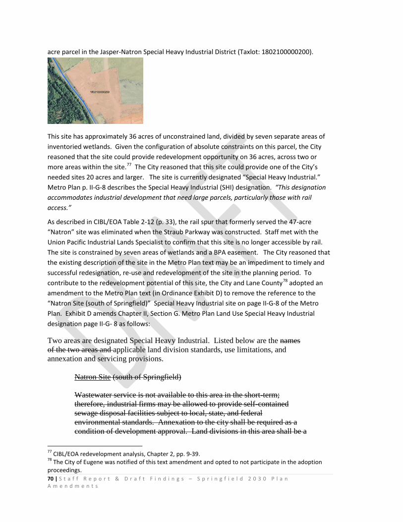
70 | S t a f f R e p o r t & D r a f t F i n d i n g s – S p r i n g f i e l d 2 0 3 0 P l a n A m e n d m e n t s
acre parcel in the Jasper-Natron Special Heavy Industrial District (Taxlot: 1802100000200).
This site has approximately 36 acres of unconstrained land, divided by seven separate areas of inventoried wetlands. Given the configuration of absolute constraints on this parcel, the City reasoned that the site could provide redevelopment opportunity on 36 acres, across two or more areas within the site.77 The City reasoned that this site could provide one of the City’s needed sites 20 acres and larger. The site is currently designated “Special Heavy Industrial.” Metro Plan p. II-G-8 describes the Special Heavy Industrial (SHI) designation. “This designation accommodates industrial development that need large parcels, particularly those with rail access.”
As described in CIBL/EOA Table 2-12 (p. 33), the rail spur that formerly served the 47-acre “Natron” site was eliminated when the Straub Parkway was constructed. Staff met with the Union Pacific Industrial Lands Specialist to confirm that this site is no longer accessible by rail. The site is constrained by seven areas of wetlands and a BPA easement. The City reasoned that the existing description of the site in the Metro Plan text may be an impediment to timely and successful redesignation, re-use and redevelopment of the site in the planning period. To contribute to the redevelopment potential of this site, the City and Lane County78 adopted an amendment to the Metro Plan text (in Ordinance Exhibit D) to remove the reference to the “Natron Site (south of Springfield)” Special Heavy Industrial site on page II-G-8 of the Metro Plan. Exhibit D amends Chapter II, Section G. Metro Plan Land Use Special Heavy Industrial designation page II-G- 8 as follows:
Two areas are designated Special Heavy Industrial. Listed below are the names of the two areas and applicable land division standards, use limitations, and annexation and servicing provisions.
Natron Site (south of Springfield)
Wastewater service is not available to this area in the short-term; therefore, industrial firms may be allowed to provide self-contained sewage disposal facilities subject to local, state, and federal environmental standards. Annexation to the city shall be required as a condition of development approval. Land divisions in this area shall be a
77 CIBL/EOA redevelopment analysis, Chapter 2, pp. 9-39. 78 The City of Eugene was notified of this text amendment and opted to not participate in the adoption proceedings.

71 | S t a f f R e p o r t & D r a f t F i n d i n g s – S p r i n g f i e l d 2 0 3 0 P l a n A m e n d m e n t s
minimum of 40 acres until annexation to Springfield has been assured. While industrial park development will be encouraged on this site, opportunity for the siting of industries that require large lots, such as 20 acres or more, will be reserved through the conceptual development planning and site review process.
The City incorporated the Exhibit D text amendment into its 2030 Plan amendment to remove an unnecessary regulatory impediment to redevelopment. The City is not redesignating or rezoning the SHI property at this time and SHI uses and “any industry which meets the applicable siting criteria may make use of this designation”79 continue to be permitted. Previous visioning for the entire Jasper-Natron area with input from citizens and property owners indicated that the SHI designation is no longer appropriate for this site and that a more flexible Light Industrial or General Employment Designation would encourage re-use or redevelopment of this property in the planning period. The Exhibit D text amendment facilitates redesignation and rezoning of this site in the future. The City and Lane County also adopted a general policy and implementation strategies providing direction for future plan or zoning amendments that could be implemented to address this site and others like it:
2030 Plan Economic Element Policy E.45 states:
“Consider amendments to regulations that will increase predictability and flexibility for industrial site redevelopment and expansion.”
2030 Plan Economic Element Policy Implementation Strategy 45.1 states:
“Consider establishing a new general “Industrial” plan designation to support several different kinds of industrial development.”
2030 Plan Economic Element Policy Implementation Strategy 45.2 states:
“Consider establishing a new “Employment” plan designation and zone that allows a broader array of general industrial uses and develop updated buffering standards.”
2030 Urbanization Element Implementation Strategy 1.3 states:
“Encourage and support redesignation, rezoning, environmental clean-up and redevelopment of brownfields and older industrial sites to allow these lands to redevelop with clean industries and new uses, especially when located in the Willamette Greenway, adjacent to waterways and high value wetlands, and in Drinking Water Protection Zones 1-2 Year TOTZ areas. Provide information to businesses to encourage and facilitate environmental remediation, relocation, and/or redevelopment of these sites.”
2030 Urbanization Element Implementation Strategy 2.1 states:
79 Metro Plan p. II-G-8
72 | S t a f f R e p o r t & D r a f t F i n d i n g s – S p r i n g f i e l d 2 0 3 0 P l a n A m e n d m e n t s
“Preserve large (20 acres or greater) Heavy Industrial, Light Industrial, Campus Industrial and Employment Mixed Use sites for industrial and other employment uses that require large sites, while allowing redesignations that allow limited supporting retail uses (e.g. food and beverage) within the building to support the primary employment use.”
2030 Urbanization Element Policy E.3 states:
“Work with property owners and their representatives to ensure that prime development and redevelopment sites throughout Springfield and its Urban Growth Boundary that are designated for employment use are preserved for future employment needs and are not subdivided or used for non-employment uses.”
As explained in Table 2-12, the City assumes that six potentially redevelopable sites 5-20 acres offer redevelopment opportunities in the 2010-2030 planning period as follows:
• 12-acre site in the Jasper-Natron Special Heavy Industrial District • 10-acre site on 28th Street in Heavy Industrial • 8-acre site on 42nd Street in Heavy Industrial • 7-acre site at 28th and Marcola Road in Heavy Industrial • 6.5-acre site on 28th Street in Heavy Industrial • 6-acre site on Highbanks Road in Heavy Industrial
The City assumed the seven potentially redevelopable sites will be available in the planning period, thus the City reduced the number of needed industrial sites 20 acres and larger by one industrial site80, and reduced the number of needed sites 5-20 acres by six sites. Application of this assumption reduced the amount of land needed in the UGB expansion. 81
The CIBL/EOA assumes all of Springfield’s needs for industrial and commercial sites less than 5 acres in size will be met within the existing UGB. Application of this assumption reduced the amount of land needed in the UGB expansion by 2 sites and 6 acres.82
2030 Policy commitments to redevelopment and designation of additional land for mixed-use development to meet site needs. As previously stated, the CIBL/EOA83 assumes that all of Springfield’s needs for industrial and commercial sites less than 5 acres in size will be met within the existing UGB. As shown in CIBL/EOA Appendix C, Table C-10, “Minimum acreage needs, 20,000 and 50,000 sq. ft. building” , some of Springfield’s target employers that locate on “urban office” or “campus style office” sites can locate on vacant or developed, or redevelopable sites smaller than 5 acres. These office uses
80 This reduction applied to the number of needed sites and acres can be seen by comparing the figures in CIBL/EOA Tables 5-1 and 5-3, pp. 78-79. 81 See CIBL/EOA Table 5-1, p. 78. 82 See CIBL/EOA Tables 5-3 and 5-4 showing the reduction of needed sites <5 acres from 2 to 0, and the number of needed acres from 230 to 223, pp. 79 and 80 83 CIBL/EOA p. 79
73 | S t a f f R e p o r t & D r a f t F i n d i n g s – S p r i n g f i e l d 2 0 3 0 P l a n A m e n d m e n t s
include Back Office, Headquarters, and Professional/Technical Services that require 50,000 square feet or less. Urban office space could be part of mixed-use developments.
The City’s previously adopted UGB and Residential Land Use and Housing Element committed the City to meeting all residential land use needs for the 2010-2030 planning period without expanding the UGB. The CIBL/EOA assumes 22% of needed employment will occur on “potentially redevelopable” sites.84 These facts point to the need for ample Springfield policy support for redevelopment — including land designated and zoned to accommodate mixed use development —on sites within the existing UGB. To that end, the City and Lane County adopted a UGB and policy commitments that support and rely upon more mixed-use development in Springfield to meet multiple land use needs within its limited and constrained land supply.
2030 Economic Element policies and implementation strategies
The 2030 Economic Element describes Springfield’s focused public policy strategy to accommodate employment growth needs on smaller sites by enabling a high level of redevelopment activity.
2030 Economic Element Policy E.1 states:
“Designate an adequate supply of land that is planned and zoned to provide sites of varying locations, configurations, size and characteristics as identified and described in the Economic Opportunity Analysis to accommodate industrial and other employment over the planning period. These sites may include vacant undeveloped land; partially developed sites with potential for additional development through infill development; and sites with redevelopment potential.”
2030 Economic Element Implementation Strategy 1.2 states:
“Continue to conduct focused neighborhood, district, and corridor refinement planning processes that engage the community to identify sites with potential for infill and redevelopment; and work collaboratively to update planning and zoning to support job creation and more efficient land use.”
The City and Lane County adopted a set of Economic Element policies and strategies committing the City to refinement, corridor and district planning updates that will designate and zone more land to add to Springfield’s existing inventory of land designated and zoned Mixed-Use — creating additional opportunities for mixed-use development in Springfield (E.8, E. 9, E.10, E.19, E.22 and Implementation Strategies 4.1, 4.3, 4.4, 4.5, 4.6, 8.2, 8.3, 9.1, 9.2, 9.3, 9.4, 9.5, 9.6, 10.1, 10.2, 10.3, 10.4, 10.5, 10.6, 16.1, 16.2, 16.3, 22.1, 22.4, 24.3, 40.6, 40.7, 40.8.
2030 Economic Element Policy E.6 states:
84 CIBL/EOA page vi, Figure S-1

74 | S t a f f R e p o r t & D r a f t F i n d i n g s – S p r i n g f i e l d 2 0 3 0 P l a n A m e n d m e n t s
“Facilitate short term and long term redevelopment activity and increased efficiency of land use through the urban renewal program, updates to refinement plans and the development review process.”
2030 Economic Element Policy E.7 states:
“Where possible, concentrate development on sites with existing infrastructure or on sites where infrastructure can be provided relatively easily and at a comparatively low cost.”
2030 Economic Element Implementation Strategy 4.3 states:
“Establish an “Employment Mixed-Use” plan designation to allow secondary supporting land uses in walkable employment centers served by multiple modes of transportation to support the goals of compact urban development.”
2030 Economic Element Implementation Strategy 4.4 states:
“Prepare or update refinement, corridor and district plans to create more opportunities for mixed land uses. Prioritize planning for mixed-used development that includes retail, office commercial, and multifamily housing in downtown, Glenwood, along the Main Street corridor and along the Downtown to Gateway transit corridor.”
2030 Economic Element Implementation Strategy 4.5 states:
“Continue to support policies and develop implementation tools to encourage economically feasible mixed-use development and nodal development in Springfield’s downtown, Glenwood, and in mixed-use nodes in locations identified through the refinement planning process.”
2030 Economic Element Implementation Strategy 4.6 states:
“Encourage co-location of residential and commercial uses in existing buildings by developing resources to make available financial assistance for necessary building upgrades to meet requirements in the building code, such as improvements to meet seismic standards.”
2030 Economic Element Implementation Strategy 24.3 states:
“Support property-owner initiated proposals to redesignate and rezone commercial land located outside of any neighborhood refinement plan areas adopted after June 2011 to Residential Mixed-Use when consistent with Springfield 2030 Plan policies.”
2030 Economic Element Policy 8 states:
75 | S t a f f R e p o r t & D r a f t F i n d i n g s – S p r i n g f i e l d 2 0 3 0 P l a n A m e n d m e n t s
“Continue implementing the Downtown District Plan and Implementation Strategy adopted in 2010 to guide revitalization and redevelopment in downtown as resources are available.”85
2030 Economic Element Implementation Strategy 8.2 states:
“Amend the Downtown Refinement Plan and Downtown Mixed Use Zone to create new capacity and support for downtown employment uses that use land more efficiently and minimizes the costs of providing infrastructure.”
2030 Economic Element Implementation Strategy 8.8 states:
“Continue to leverage and expand Downtown Springfield as the City’s civic and government center by promoting, investing and seeking opportunities to locate new federal, state and local civic buildings in Downtown or, — if Downtown sites are not readily available — in locations with excellent transit connections to or through Downtown.”
2030 Economic Element Policy 9 states:
“Encourage and facilitate redevelopment of Glenwood as a mixed use housing, employment and commercial center.”
2030 Economic Element Implementation Strategy 9.1 states:
“Continue to support redevelopment of sites in Glenwood through planning, key investments, innovative development standards, and focused activity through the Springfield Economic Development Agency (SEDA), the Glenwood Urban Renewal Plan, the Glenwood Refinement Plan and the Glenwood Riverfront Plan Mixed-Use Plan District."86
2030 Economic Element Implementation Strategy 9.2 states:
“Provide the public infrastructure and services necessary for development in Glenwood, as funds allow.”
2030 Economic Element Implementation Strategy 9.3 states:
“Coordinate economic development in Glenwood with regional and State economic development efforts.”
2030 Economic Element Implementation Strategy 9.4 states:
85 Springfield City Council Resolution 10-57 86 SDC 3.4-200
76 | S t a f f R e p o r t & D r a f t F i n d i n g s – S p r i n g f i e l d 2 0 3 0 P l a n A m e n d m e n t s
“Assist economic development in Glenwood through techniques such as optioning land, land assembly, and cooperative development agreements to assist developers with land assembly issues.”
2030 Economic Element Implementation Strategy 9.5 states:
“Recruit anchor institutions, such as academic and health care institutions to locate in Springfield. Recruit to establish a University of Oregon anchor land use in Glenwood to stimulate private investment in redevelopment of vacant or neglected sites.”
2030 Economic Element Implementation Strategy 9.6 states:
“Implement the Glenwood Riverfront District/Franklin Corridor District Plan and Phase One plan amendments adopted in 2012.”87
2030 Economic Element Policy E.10 states:
“Continue to provide public policy and financial support when possible for redevelopment in Springfield. Through the annual Goal-setting process, the City Council shall identify redevelopment target areas.”
2030 Economic Element Implementation Strategy 10.1 states:
“Continue to conduct focused refinement planning in key redevelopment areas, as directed by the City Council, and as resources are available.”
2030 Economic Element Implementation Strategy 10.3 states:
“When preparing or amending refinement plans, work with neighborhood groups to identify needs and opportunities for creating neighborhood mixed use centers near schools and parks to encourage development of neighborhood-serving “corner store” scale retail, small office or live-work units in or adjacent to residential areas. Consider establishing a Neighborhood Commercial Mixed Use designation.”
2030 Economic Element Implementation Strategy 10.4 states:
“Designate a Neighborhood Mixed Use center in Jasper Natron within one half mile of the future school/park sites.”
2030 Economic Element Implementation Strategy 10.5 states:
“Encourage opportunities for employment close to residences, including mixed-use development.”
2030 Economic Element Implementation Strategy 10.6 states:
87 SDC 3.4-200 was adopted into the Code in 2013

77 | S t a f f R e p o r t & D r a f t F i n d i n g s – S p r i n g f i e l d 2 0 3 0 P l a n A m e n d m e n t s
“Establish Employment Mixed-Use plan designations that could be applied to land along the existing and proposed future high capacity transit corridors and in Nodal Development areas.”
2030 Economic Element Implementation Strategy 22.1 states:
“Expand the Downtown Refinement Plan boundary and Downtown Mixed Use District to support additional commercial activity and to create a more viable retail commercial center as envisioned in the 2010 Downtown District Urban Design Plan and Implementation Strategy; and engage the Downtown Citizen Advisory Committee, Historic Commission and property owners to ensure that the form, scale and intensity of new development contributes positively to the adjacent Washburne Historic District neighborhood. Consider that 100,000-125,000 square feet of retail is required for a viable retail destination district; 50,000-60,000 square feet is needed for an anchor use, such as a grocery store or theater multiplex; and contemporary retail businesses need wider and less deep space than currently provided by buildings on Main Street.”
2030 Economic Element Implementation Strategy 24.4 states:
“Work with property owners and stakeholders through the Main Street Corridor planning process to consider allowing Medium or High Density residential uses in existing commercial zones in addition to commercial uses.”
2030 Economic Element Implementation Strategy 25.2 states:
“Study the feasibility of applying an Employment Mixed-Use or “employment transition” zoning concept to land along the south side of South A Street to support mixed-use redevelopment activity adjacent to the downtown Booth-Kelly center and Mill Race restoration areas when development is compatible with the existing and future use of the rail corridor.”
The City and Lane County adopted policies and strategies committing the City to plan and support redevelopment in Downtown (Policy E.20 and Implementation Strategies 22.1, 22.3) Glenwood (Policy E.21), Main Street Corridor (I.S. 22.9, 24.4), Jasper-Natron (Implementation Strategy 22.6), Mohawk Center (I.S. 22.7)(Policies E.20, E.21, E.22).
The City and Lane County adopted policies and strategies committing the City to provide more zoning flexibility for developing industrial or business parks to support clustering of related or complementary businesses.
Economic Element Policy E.4 states:
“Expand industrial site opportunities through evaluating and rezoning commercial, residential, and industrial land for the best economic return for the community
78 | S t a f f R e p o r t & D r a f t F i n d i n g s – S p r i n g f i e l d 2 0 3 0 P l a n A m e n d m e n t s
through the process of Periodic Review of the Metro Plan, refinement plans, master plans, expanding the urban growth boundary, and other means.”
2030 Urbanization Element Policy 2 states:
“Continue to support and facilitate redevelopment and efficient urbanization through City-initiated area-specific refinement planning and zoning amendments consistent with the policies of this Plan. Plans shall designate an adequate and competitive supply of land to facilitate short-term and long-term redevelopment activity. Efficiency measures achieved through plan amendments may be reflected in land supply calculations to the extent that they are likely to increase capacity of land suitable and available to meet identified needs during the relevant planning period.”
2030 Urbanization Element Policy 3 states:
“Balance the goals of accommodating growth and increasing average density within the city with goals to stabilize and preserve the established character of sound older neighborhoods. The City shall adopt detailed area-specific refinement plans to clearly define locations where significant growth and redevelopment is expected, and to establish policies and zoning to guide the design of higher density development.”
• “Continue to provide public policy and financial support when possible for redevelopment in Springfield.”
• “Continue to prioritize and incentivize redevelopment in the
Glenwood and Downtown urban renewal districts and support redevelopment throughout the City as described in the Economic and Residential Elements of this Plan.”
• “Continue to provide development tools and incentives (such as Urban Renewal support) within targeted priority redevelopment areas as resources become available to facilitate expedient and economically feasible redevelopment.”
• “Continue to conduct focused planning in key redevelopment areas, as directed by the City Council, as resources are available. Such efforts will review, update and supersede existing refinement plan designations and policies.”
• “Identify and include public agencies and private stakeholder partners in district-specific planning efforts to facilitate redevelopment through partnerships and other cooperative relationships.”
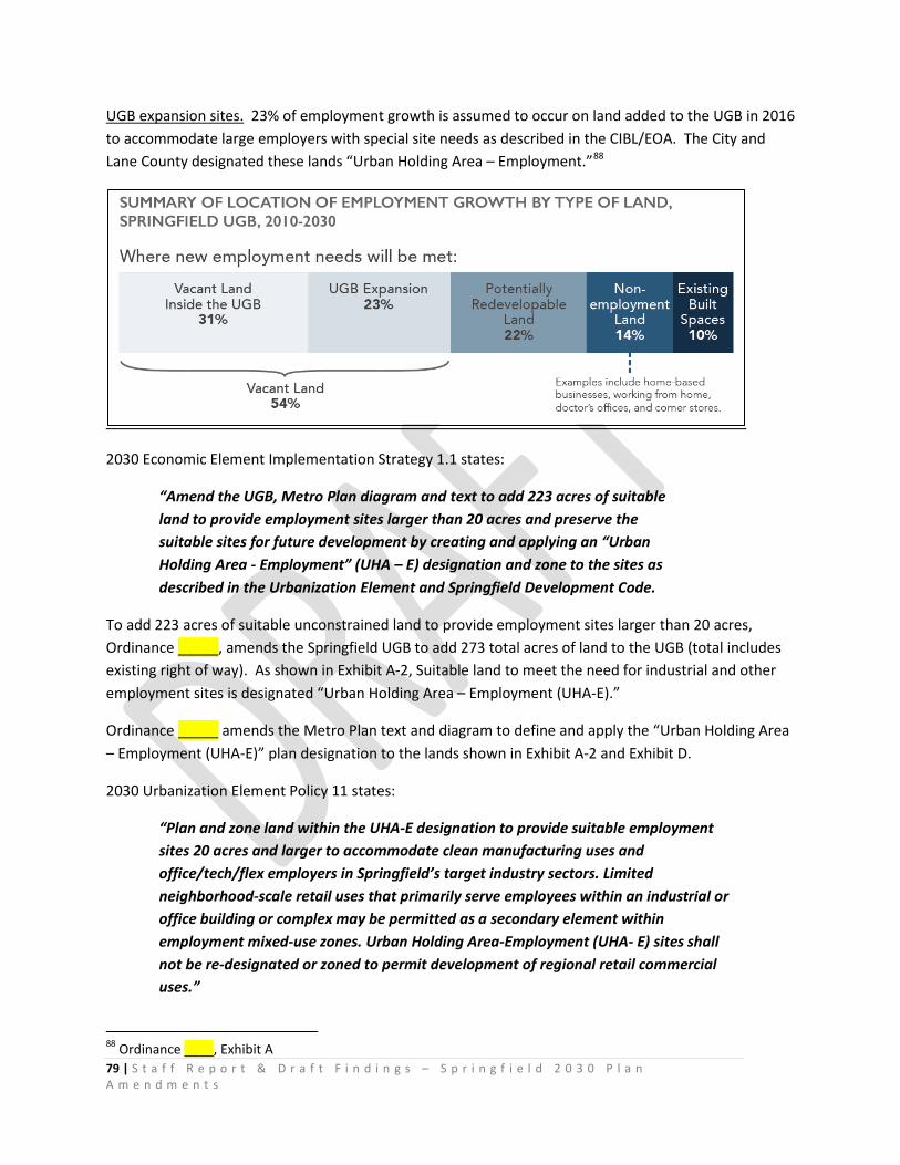
79 | S t a f f R e p o r t & D r a f t F i n d i n g s – S p r i n g f i e l d 2 0 3 0 P l a n A m e n d m e n t s
UGB expansion sites. 23% of employment growth is assumed to occur on land added to the UGB in 2016 to accommodate large employers with special site needs as described in the CIBL/EOA. The City and Lane County designated these lands “Urban Holding Area – Employment.”88
2030 Economic Element Implementation Strategy 1.1 states:
“Amend the UGB, Metro Plan diagram and text to add 223 acres of suitable land to provide employment sites larger than 20 acres and preserve the suitable sites for future development by creating and applying an “Urban Holding Area - Employment” (UHA – E) designation and zone to the sites as described in the Urbanization Element and Springfield Development Code.
To add 223 acres of suitable unconstrained land to provide employment sites larger than 20 acres, Ordinance _____, amends the Springfield UGB to add 273 total acres of land to the UGB (total includes existing right of way). As shown in Exhibit A-2, Suitable land to meet the need for industrial and other employment sites is designated “Urban Holding Area – Employment (UHA-E).”
Ordinance _____ amends the Metro Plan text and diagram to define and apply the “Urban Holding Area – Employment (UHA-E)” plan designation to the lands shown in Exhibit A-2 and Exhibit D.
2030 Urbanization Element Policy 11 states:
“Plan and zone land within the UHA-E designation to provide suitable employment sites 20 acres and larger to accommodate clean manufacturing uses and office/tech/flex employers in Springfield’s target industry sectors. Limited neighborhood-scale retail uses that primarily serve employees within an industrial or office building or complex may be permitted as a secondary element within employment mixed-use zones. Urban Holding Area-Employment (UHA- E) sites shall not be re-designated or zoned to permit development of regional retail commercial uses.”
88 Ordinance ____, Exhibit A
80 | S t a f f R e p o r t & D r a f t F i n d i n g s – S p r i n g f i e l d 2 0 3 0 P l a n A m e n d m e n t s
2030 Urbanization Element Policy 12 states:
“Master plans are required for contiguous ownerships over 5 acres designated UHA-E and shall address all of the policies of this Plan and the Master Plan requirements of the Springfield Development Code.”
2030 Urbanization Element Policy 22 states:
“Plan and zone the North Gateway UHA-E area to guide development of a well-designed employment district adjacent to the Interstate 5 economic corridor to support diversification and improvement of the local, regional and state economies and to make efficient use of existing and planned public transportation systems and infrastructure. Applicant-initiated plan designation and zoning changes shall address logical extension of transportation and public facilities to serve the entire North Gateway UHA-E district. Development within the North Gateway District shall be zoned and designed to enhance the distinctive physical surroundings and natural resources of the area while accommodating growth and change through implementation of attractive building exteriors and low impact development practices.”
The Springfield UGB as amended provides land for employers requiring sites larger than 20 acres sites 5-20 acres and preserves suitable sites for future development by creating and applying an “Urban Holding Area - Employment Opportunity Area” (UHA – EOA) plan designation and “Agriculture – Urban Holding Area” zoning to the sites as described in the Urbanization Element and Springfield Development Code.
The City and Lane County designated suitable employment sites larger than 5 acres and adopted policies to protect sites larger than 20 acres from land divisions.
Economic Element Policy E.2 states:
“Establish minimum parcel sizes within the “Urban Holding Area - Employment “(UHA – E) designated areas to reserve suitable parcels 20 acres or larger and suitable parcels larger than 50 acres.
2030 Urbanization Element Policy 7 states:
“For lots/parcels greater than 50 acres in the North Gateway UHA-E District, the minimum lot/parcel size for land division is 50 acres. Land divisions that create lots/parcels for the purpose of establishing a Natural Resource or Public/Semi-Public Parks and Open Space designation within the floodway, wetland or riparian resource portions of the site may create lots/parcels less than 50 acres within the Natural Resource or Public/Semi-Public Parks and Open Space designation portion of the parent lot/parcel. Lots/parcels created and designated for employment purposes shall
81 | S t a f f R e p o r t & D r a f t F i n d i n g s – S p r i n g f i e l d 2 0 3 0 P l a n A m e n d m e n t s
retain the 50-acre minimum until planned and zoned to allow annexation and site development with urban employment uses and densities consistent with the policies of this Plan.”
2030 Urbanization Element Policy 8 states:
“For lots/parcels less than 50 acres in the North Gateway and Mill Race UHA-E Districts, the minimum lot/parcel size for land division is 20 acres. Land divisions that create lots/parcels for the purpose of establishing a Natural Resource or Public/Semi-Public Parks and Open Space designation within the floodway, wetland or riparian resource portions of the site may create lots/parcels less than 20 acres within the Natural Resource or Public/Semi-Public Parks and Open Space designation portion of the lot/parcel. Lots/parcels created and designated for employment purposes shall retain the 20-acre minimum until planned and zoned to allow annexation and site development with urban employment uses and densities consistent with the policies of this Plan.”
2030 Economic Element Policy 3 states:
“Work with property owners and their representatives to ensure that prime development and redevelopment sites throughout Springfield and its Urban Growth Boundary that are designated for employment use are preserved for future employment needs and are not subdivided or used for non-employment uses.”
2030 Economic Element Implementation Strategy 11.1 states:
“Plan, zone and reserve a sufficient supply of industrial and commercial buildable land to create opportunity sites for employment uses identified in the 2015 Economic Opportunities Analysis (EOA), with an initial emphasis on Target Industries listed in the analysis Table S-1, Target Industries, Springfield 2010-2030 (page iii-iv.)”
2030 Economic Element Implementation Strategy 12.4 states:
“Encourage the location and expansion of traded sector industries as a means to increase the average wage and contribute to the growth of the local sector economy.”
2030 Economic Element Implementation Strategy 12.5 states:
“Support increased potential for employment in one of the regional industry clusters.”
Commitments to provide necessary public facilities and transportation facilities for the newly urbanizable portion of the planning area. The City’s 2030 Plan policies are coordinated with existing public facilities and transportation plan policies to provide necessary public facilities and transportation facilities for the Springfield planning area. The 2030 Plan continues to rely upon the acknowledged
82 | S t a f f R e p o r t & D r a f t F i n d i n g s – S p r i n g f i e l d 2 0 3 0 P l a n A m e n d m e n t s
Metro Plan policies for coordination of public facilities planning at the Metro area level and transportation system planning at the MPO level to provide public facilities and transportation facilities for the planning area. 2030 Urbanization Element policies 43 and 44 (Ordinance Exhibit C-1) commit the city to update public facilities planning and transportation system planning as may be necessary to provide public facilities and transportation facilities for the newly urbanizable lands added to the UGB planning area prior to approval of a plan amendment or zone change that allows transition from rural to urban uses and densities.
2030 Urbanization Element Policy 9 states:
“As directed by the City Council, the City will conduct comprehensive planning processes and adopt refinement-level plans and implementation measures to guide and regulate urban development in the North Gateway and Mill Race UHA-E districts. The Transportation Planning Rule requirements under OAR 660-012-0060 will be addressed prior to any re-designation or zoning map amendment that allows urbanization.”
2030 Urbanization Element Policy 23 states:
“Amend the Gateway Refinement Plan to include the North Gateway UHA-E area prior to or concurrent with approval of an owner-initiated plan amendment or zone change that allows urban development in the North Gateway UHA-E area. The amended Gateway Refinement Plan shall describe the logical extension of transportation and public facilities to serve the entire North Gateway UHA-E area.”
2030 Urbanization Element Policy 27 states:
“The coordinated, timely provision of urban services is a central element of the City’s comprehensive growth management strategy for infill, redevelopment and new development. Development undertaken in pursuit of housing goals, diversifying the economy and neighborhood livability shall occur only after the logical and efficient delivery of all urban services have been provided to these sites.”
2030 Urbanization Element Policy 28 states:
“Regionally significant public investments within Springfield’s UGB shall be planned on a metropolitan-wide basis, as described in the regional transportation and public facilities plans.”
2030 Urbanization Element Policy 37 states:
“Prior to re-designating and rezoning land designated Urban Holding Area- Employment, the City shall update and adopt amendments to the Eugene-Springfield
83 | S t a f f R e p o r t & D r a f t F i n d i n g s – S p r i n g f i e l d 2 0 3 0 P l a n A m e n d m e n t s
Metropolitan Public Facilities and Services Plan (PFSP) that may be needed to identify new facilities or major modification of facilities needed to serve development of urban employment uses within the North Gateway or Mill Race districts as necessary to demonstrate accordance with statewide planning Goal 11 and Goal 11 administrative rules requirements and the policies of Metro Plan Chapter III-G Public Facilities Element of the Metro Plan.”
2030 Economic Element Policy E.13 states:
“Advocate for and support State, Federal and Metro regional transportation network development policies and initiatives that strengthen Springfield’s economic corridor connections and development/redevelopment potential.”
2030 Economic Element Implementation Strategy 8.3 states:
“Amend infrastructure plans as necessary to include the infrastructure and services that businesses need to operate in downtown Springfield.”
2030 Economic Element Implementation Strategy 8.7 states:
“Collaborate with Springfield Utility Board and other service providers to minimize cost of upgrading and modernizing downtown infrastructure.”
2030 Economic Element Implementation Strategy 13.1 states:
“Take advantage of new commercial and residential development opportunities that will be stimulated by the infrastructure projects identified in the Springfield TSP, such as the Franklin Boulevard improvements in Glenwood.”
2030 Economic Element Policy E.21 states:
“Plan and support redevelopment of the Glenwood Franklin Riverfront and Downtown districts to be mutually supportive and seek funding to connect the two districts with a pedestrian/bike bridge.”
2030 Economic Element Policy E.16 states:
“Consider the economic opportunities provided by transportation corridors and seek to maximize economic uses in corridors that provide the most optimal locations and best exposure for existing and future commercial and industrial uses.”
2030 Economic Element Implementation Strategy 16.1 states:
“Develop a Main Street/Oregon Highway 126 corridor plan to update land use designations, zoning, and development standards; evaluate potential nodal
84 | S t a f f R e p o r t & D r a f t F i n d i n g s – S p r i n g f i e l d 2 0 3 0 P l a n A m e n d m e n t s
development areas; and coordinate with Lane Transit District’s planning for potential transit system improvements.”
2030 Economic Element Implementation Strategy 16.2 states:
“Identify future economic corridor or district improvement areas to be targeted with refinement planning (e.g. Downtown to Gateway, Mid-Main to Mohawk, Urban Holding Areas).”
2030 Economic Element Implementation Strategy 16.3 states:
“Plan and zone land to maximize utilization of excellent exposure along Main Street/Highway 126B and Pioneer Parkway as future downtown commercial and employment development sites, as envisioned in the 2010 Downtown District Urban Design Plan.”
2030 Economic Element Policy E.17 states:
“Leverage existing rail facilities and future expansion of rail facilities to achieve economic development objectives.”
2030 Economic Element Implementation Strategy 17.4 states:
“Work with railroad industrial land specialist staff and Springfield property owners to conduct an inventory of Springfield’s existing rail facilities and create a list of industrial sites with existing or previous rail service and/or potential for new service, including opportunities to utilize freight rail line connectivity between Springfield and the Coos Bay port.”
2030 Economic Element Implementation Strategy 17.5 states:
“Consider how future expansion of rail freight will affect land use and avoid re-zoning industrial land with rail access to non-industrial uses, while allowing some conversion of existing industrial land to other employment uses, especially in high visibility areas such as the South A corridor east of Downtown, if uses are compatible with heavy rail impacts.”
2030 Economic Element Policy E.18 states:
“Coordinate transportation and land use corridor planning to include design elements that support Springfield’s economic and community development policies and contribute to community diversity and inclusivity.”
2030 Economic Element Implementation Strategy 18.3 states:
85 | S t a f f R e p o r t & D r a f t F i n d i n g s – S p r i n g f i e l d 2 0 3 0 P l a n A m e n d m e n t s
“Establish preferred design concepts for key intersections along the corridor that integrate vehicle, pedestrian, bicycle and transit needs.”
2030 Economic Element Implementation Strategy 18.7 states:
“Prioritize improvements that would complete local connections to local shopping and service opportunities.”
Springfield’s existing acknowledged plan and zoning map designations, public facility plans, and transportation system plans, and Springfield Development Code land use regulations — as amended through adoption and acknowledgement of the 2030 Plan amendments — are adequate to implement policies the City and Lane County adopted pursuant to OAR 660-009-0020.
Conclusion OAR 660-009-0020(1)(c): The City’s 2030 Plan Amendments include policy commitments to provide an adequate number of suitable employment sites, types and locations and necessary public facilities and transportation facilities for the planning area.
OAR 660-009-0020(2)
“Plans for cities and counties within a Metropolitan Planning Organization or that adopt policies relating to the short-term supply of land, must include detailed strategies for preparing the total land supply for development and for replacing the short-term supply of land as it is developed. These policies must describe dates, events or both, that trigger local review of the short-term supply of land.”
2030 Economic Element Policy E.5 states:
“Provide an adequate, competitive short-term supply of suitable land to respond to economic development opportunities as they arise. “Short-term supply" means suitable land that is ready for construction within one year of an application for a building permit or request for service extension. "Competitive Short-term Supply" means the short-term supply of land provides a range of site sizes and locations to accommodate the market needs of a variety of industrial and other employment uses.”
The CIBL/EOA (pages 40-41) presents an analysis of short-term supply. Most of Springfield’s land supply within the existing UGB (91% of vacant commercial and industrial land and 85% of land with redevelopment potential) is considered short-term supply because land can be ready for construction within one year based on “engineering feasibility.” The short-term supply meets and exceeds the 25% threshold of OAR 660-009-0025 (3)(a).
Springfield has two urban renewal districts: Glenwood U.D. and Downtown U.D. Both districts have urban renewal plans and financing programs administered by the Springfield Economic Development Agency (SEDA) through the City Manager’s Office Economic Development Department. Programs provide support, as funds become available, to plan and prepare the land supply for redevelopment.
86 | S t a f f R e p o r t & D r a f t F i n d i n g s – S p r i n g f i e l d 2 0 3 0 P l a n A m e n d m e n t s
The urban renewal program, as funds allow, supports provision of a competitive short-term supply of land in Springfield providing a range of commercial, industrial and mixed-use site sizes and locations to accommodate the market needs of a variety of industrial and other employment uses. 89
Conclusion OAR 660-009-0020(2): The City and Lane County adopted 2030 Plan Economic Element Policy E.5 to state a commitment to providing a competitive short-term supply of land to accommodate industrial and other employment uses it selected through the economic opportunities analysis. The City and Lane County adopted 2030 Plan Urbanization Element text, policies and strategies describing how Springfield’s total supply of urbanizable land, including land in the short-term supply is planned and prepared for development.
OAR 660-009-0020(3)
“Plans may include policies to maintain existing categories or levels of industrial and other employment uses including maintaining downtowns or central business districts.”
As described in the CIBL inventory, the City’s 2030 Plan Amendments assume Springfield will maintain existing categories or levels of industrial and other employment uses as described in the Metro Plan and associated facilities plans. Any future amendments to existing categories or levels of industrial and other employment uses, policies or implementation strategies are addressed through future plan amendments. Existing categories or levels of industrial and other employment uses are assumed as described in the Metro Plan, associated facilities plans, and the Springfield Development Code.
As described on pages 74-84 of this report, the City’s 2030 Plan Amendments include policies and implementation strategies to support Downtown revitalization and redevelopment — maintaining and growing Springfield’s Downtown District as an important center of employment and commerce. 90
Conclusion OAR 660-009-0020(3): The 2030 Plan includes policies to maintain existing categories or levels of industrial and other employment uses including maintaining downtowns or central business districts.
OAR 660-009-0020(4)
“Plan policies may emphasize the expansion of and increased productivity from existing industries and firms as a means to facilitate local economic development.”
The City’s analysis of trends in the CIBL/EOA assumes the expansion of some existing industries and firms (e.g. Medical cluster) as a means to facilitate local economic development.
89 For example, in 2016 SEDA is providing public assistance and financing support for infrastructure upgrades of Franklin Boulevard/McVay Highway and land assembly to assist in preparing Glenwood sites for redevelopment. 90 In 2016, the City is updating its Downtown Design and Streetscape Development Standards though amendments to the Springfield Development Code and Engineering Design Standards Manual, with assistance from the Oregon TGM Code Assistance Program.

87 | S t a f f R e p o r t & D r a f t F i n d i n g s – S p r i n g f i e l d 2 0 3 0 P l a n A m e n d m e n t s
Conclusion OAR 660-009-0020(4): The CIBL/EOA and the City’s plan policies designate land and regulate land uses to provide a supply of suitable sites to accommodate expansion and increased productivity from existing industries and firms that are expected to grow in the 2010-2030 planning period.
OAR 660-009-0020(5)
“Cities and counties are strongly encouraged to adopt plan policies that include brownfield redevelopment strategies for retaining land in industrial use and for qualifying them as part of the local short-term supply of land.”
The City’s 2030 Plan Amendments include policies and implementation strategies to support brownfield redevelopment.
2030 Plan Economic Element Policy E.27 states:
“Support clean up and re-use of brownfields and contaminated sites as the opportunities for reuse arise.”
2030 Plan Economic Element Implementation Strategies 27.1 and 27.2 state:
“Provide public support to identify, assess, clean up and redevelop brownfields as resources become available through grants, SEDA, community partnerships and private investments.”
“Seek and leverage funding for brownfield assessment and clean up as one key tool to assist financing for redevelopment.”
The Springfield, Eugene and Lane County partnership has been successful in applying for, receiving and implementing EPA Brownfields Assessment Grants, demonstrating commitment to public support for assessment and clean-up of contaminated lands in the Metro area. As brownfields are assessed and cleaned up, commercial and industrial sites in Springfield’s inventory can be redeveloped with appropriate industrial and other employment uses.
“Encourage and support redesignation, rezoning, environmental clean-up and redevelopment of brownfields and older industrial sites to allow these lands to redevelop with clean industries and new uses, especially when located in the Willamette Greenway, adjacent to waterways and high value wetlands, and in Drinking Water Protection Zones 1-2 Year TOTZ areas. Provide information to businesses to encourage and facilitate environmental remediation, relocation, and/or redevelopment of these sites.”
Conclusion OAR 660-009-0020(5): Springfield and Lane County adopted 2030 plan Economic Element Policy policies and brownfield redevelopment strategies.
OAR 660-009-0020(6)
88 | S t a f f R e p o r t & D r a f t F i n d i n g s – S p r i n g f i e l d 2 0 3 0 P l a n A m e n d m e n t s
“Cities and counties are strongly encouraged to adopt plan policies pertaining to prime industrial land pursuant to OAR 660-009-0025(8).”
IVd. Employment Land Need - Uses with Special Siting Characteristics
OAR 660-009-0025(8) Uses with Special Siting Characteristics
“Cities and counties that adopt such objectives or policies providing for uses with special site needs must adopt policies and land use regulations providing for those special site needs. Policies and land use regulations for these uses must:
(a) Identify sites suitable for the proposed use;
(b) Protect sites suitable for the proposed use by limiting land divisions and permissible uses and activities that interfere with development of the site for the intended use; and
(c) Where necessary, protect a site for the intended use by including measures that either prevent or appropriately restrict incompatible uses on adjacent and nearby lands.”
OAR 660-009-0005(8) defines "Prime Industrial Land" as “land suited for traded-sector industries as well as other industrial uses providing support to traded-sector industries. Prime industrial lands possess site characteristics that are difficult or impossible to replicate in the planning area or region. Prime industrial lands have necessary access to transportation and freight infrastructure, including, but not limited to, rail, marine ports and airports, multimodal freight or transshipment facilities, and major transportation routes. Traded-sector has the meaning provided in ORS 285B.280.”
As encouraged to do so under OAR 660-009-0020(6), the City and County adopted 2030 Plan Amendments designating land suited for traded-sector industries as well as other industrial uses providing support to traded-sector industries. These industries and uses are identified in the CIBL/EOA. The City and County adopted 2030 Plan Amendments policies pertaining to uses with special site needs characteristics as identified and explained in the adopted CIBL/EOA. OAR 660-009-0025(8) states: “Special site needs include, but are not limited to large acreage sites, special site configurations, direct access to transportation facilities, prime industrial lands, sensitivity to adjacent land uses, or coastal shoreland sites designated as suited for water-dependent use under Goal 17.”
The City and County adopted 2030 Plan amendments to the UGB to provide 223 acres of suitable large site employment land. The amended UGB designates suitable large acreage sites — including sites larger than 20 acres — to accommodate target industrial and other employment uses. As previously described in this report under OAR 660-009-0015 (1), (2), (3) and (4) and as described and explained in the CIBL/EOA, needed site characteristics for Springfield target employers include but are not limited to unconstrained, serviceable sites larger than 20 acres with flat topography, access to public services and transportation facilities including public transit and designated truck routes. The City’s findings in this
89 | S t a f f R e p o r t & D r a f t F i n d i n g s – S p r i n g f i e l d 2 0 3 0 P l a n A m e n d m e n t s
report under Goal 14 describe and explain the City’s UGB Alternatives Analysis process to assess the suitability and serviceability of lands it evaluated under ORS 198.298 and Goal 14.
The 2030 Plan amendments designate suitable, large, flat, unconstrained sites in the North Gateway and Mill Race areas to meet special site needs. The City and Lane County identified sites suitable for the proposed employment uses by adopting Ordinance Exhibit A designating these lands “Urban Holding Area-Employment” (UHA-E), and by adopting text amendments to the Metro Plan (Exhibit D) establishing and describing the UHA-E designation.
Exhibit D amends Chapter II, Section G. Metro Plan Land Use Designations to add a new land use designation applicable to Springfield’s jurisdictional area of responsibility: Urban Holding Area – Employment. The text amendment inserts the following text on page II-G-9 (after Small-scale Light Industry and before Nodal Development Area):
Land Use Designations Urban Holding Area – Employment (not shown on Metro Plan Diagram) The Urban Holding Area – Employment (UHA-E) designation identifies urbanizable areas within the Springfield UGB to meet Springfield’s long term employment land needs for the 2010-2030 planning period. The UHA-E designation reserves an adequate inventory of employment sites, including sites 20 acres and larger, that are suitable for industrial and commercial mixed use employment uses that generate significant capital investment and job creation within — but not limited to — targeted industry sectors, business clusters and traded-sector industries identified in the most recent Springfield economic opportunities analysis and Springfield Comprehensive Plan Economic Element policies. Lands designated UHA-E are protected from land division and incompatible interim development to maintain the land’s potential for planned urban development until appropriate urban facilities and services are planned or available and annexation to Springfield can occur, as described in the Springfield Comprehensive Plan Urbanization Element. The UHA-E designation remains in effect until the appropriate employment designation is adopted through a City-initiated planning process or an owner-initiated plan amendment process.
The City and Lane County adopted plan policies to reserve the sites it added to the UGB to meet the needs of target industries identified in CIBL/EOA. The policies identify and protect sites suitable for the proposed uses by limiting land divisions and permissible uses and activities that interfere with development of the site for the intended use.
2030 Plan Urbanization Element Policy 4 states:
90 | S t a f f R e p o r t & D r a f t F i n d i n g s – S p r i n g f i e l d 2 0 3 0 P l a n A m e n d m e n t s
“Urbanizable lands added to Springfield’s acknowledged UGB by Ordinance ___, date ___ to meet employment needs are designated “Urban Holding Area- Employment” (UHA-E) in the Metro Plan consistent with the employment site needs criteria for their inclusion in the UGB.91 The UHA-E designation reserves employment sites within urbanizable areas of 50 or more suitable acres to support creation of economic districts that will accommodate the site needs of target employment sectors. The size of employment districts and parcels of urbanizable land designated UHA-E shall be of adequate dimension so as to maximize the utility of the land resource and enable the logical and efficient extension of infrastructure to serve the North Gateway or Mill Race urbanizable area.”
2030 Plan Urbanization Element Policy 5 states:
“Lands designated UHA-E are planned and zoned for the primary purpose of reserving an adequate inventory of large employment sites that is well located and viable for industry and not easily replicable elsewhere for employment uses that generate:
o A significant capital investment;
o Job creation within — but not limited to — targeted industry sectors, business clusters and traded-sector92 industries identified in the most recent economic opportunities analysis and Economic Element policies of this Plan.”
2030 Plan Urbanization Element Policy 11 states:
“Plan and zone land within the UHA-E designation to provide suitable employment sites 20 acres and larger to accommodate clean manufacturing uses and office/tech/flex employers in Springfield’s target industry sectors. Limited neighborhood-scale retail uses that primarily serve employees within an industrial or office building or complex may be permitted as a secondary element within employment mixed-use zones. Urban Holding Area-Employment (UHA- E) sites shall not be re-designated or zoned to permit development of regional retail commercial uses.”
2030 Plan Urbanization Element Policy 6 states:
“Lands designated “Urban Holding Area-Employment” are zoned “Agriculture – Urban Holding Area” (AG) on the Springfield Zoning Map and are subject to the development standards of the Springfield Development Code AG Zoning District.”
91 Employment site needs are explained in the Economic Element of this Plan, and in the Springfield Commercial and Industrial Buildable Lands Inventory and Economic Opportunities Analysis, 2015. 92 ORS 285A.010(9)
91 | S t a f f R e p o r t & D r a f t F i n d i n g s – S p r i n g f i e l d 2 0 3 0 P l a n A m e n d m e n t s
The City is bringing land into the UGB to accommodate the need for large employment sites. The following policies restrict land division to protect those large sites for employers that need large sites.
2030 Plan Urbanization Element Policy 7 states:
“For lots/parcels greater than 50 acres in the North Gateway UHA-E District, the minimum lot/parcel size for land division is 50 acres. Land divisions that create lots/parcels for the purpose of establishing a Natural Resource or Public/Semi-Public Parks and Open Space designation within the floodway, wetland or riparian resource portions of the site may create lots/parcels less than 50 acres within the Natural Resource or Public/Semi-Public Parks and Open Space designation portion of the parent lot/parcel. Lots/parcels created and designated for employment purposes shall retain the 50-acre minimum until planned and zoned to allow annexation and site development with urban employment uses and densities consistent with the policies of this Plan.”
The following policy requires retention of large parcels. The area’s existing Lane County zoning is EFU-25 (25-acre minimum).
2030 Plan Urbanization Element Policy 8 states:
“For lots/parcels less than 50 acres in the North Gateway and Mill Race UHA-E Districts, the minimum lot/parcel size for land division is 20 acres. Land divisions that create lots/parcels for the purpose of establishing a Natural Resource or Public/Semi-Public Parks and Open Space designation within the floodway, wetland or riparian resource portions of the site may create lots/parcels less than 20 acres within the Natural Resource or Public/Semi-Public Parks and Open Space designation portion of the lot/parcel. Lots/parcels created and designated for employment purposes shall retain the 20-acre minimum until planned and zoned to allow annexation and site development with urban employment uses and densities consistent with the policies of this Plan.”
The City’s 2030 Plan amendments apply the “Agriculture-Urban Holding Area” (AG) zone to the lands it designated “Urban Holding Area- Employment” (UHA-E). The UHA-E sites were included in the UGB to provide suitable, large, flat, unconstrained sites to meet special site needs. Urbanization Element policies are implemented through the land use regulations of the AG zone — protecting sites suitable for the proposed employment uses by limiting land divisions and permissible uses and activities that would interfere with development of the site for the intended use. The City and Lane County adopted Ordinance Exhibit E amending the Springfield Development Code to establish the AG zone and Exhibit A amending the Springfield zoning map to apply the zone.
The City and Lane County adopted Ordinance Exhibit C-1 and by adopting adopted policies and land use regulations for these uses. The City and Lane County previously designated and zoned land within the

92 | S t a f f R e p o r t & D r a f t F i n d i n g s – S p r i n g f i e l d 2 0 3 0 P l a n A m e n d m e n t s
existing UGB to provide for uses with special site needs and adopted policies and land use regulations that identify sites suitable for special uses —such as the Campus Industrial District. 93
Conclusion OAR 660-009-0020(6), OAR 660-009-0025(8): As encouraged to do so under OAR 660-009-0020(6), the City and Lane County adopted 2030 Plan Amendments designating land suited for traded-sector industries as well as other industrial uses providing support to traded-sector industries. These industries and uses are identified in the CIBL/EOA. The City and County adopted 2030 Plan Amendments policies pertaining to uses with special site needs characteristics as identified and explained in the adopted CIBL/EOA.
OAR 660-009-0020(7)
“Cities and counties are strongly encouraged to adopt plan policies that include additional approaches to implement this division including, but not limited to:
(a) Tax incentives and disincentives;
(b) Land use controls and ordinances;
(c) Preferential tax assessments;
(d) Capital improvement programming;
(e) Property acquisition techniques;
(f) Public/private partnerships; and
(g) Intergovernmental agreements.”
The City’s CIBL/EOA includes aggressive assumptions about redevelopment and about projected employment in non-employment designations.
The city supports its assumptions about accommodating employment growth and redevelopment through its adoption and implementation of proactive and aggressive redevelopment planning policies and implementation plans, including but not limited to:
• Establishment of TIF financing programs (Downtown and Glenwood Urban Renewal Districts); • Recent adoption of the Glenwood Refinement Plan Phase One plan and zoning amendments;
93 Metro Plan p. II-G-7 describes existing industrial and other employment land use designation districts and identifies special site needs for land uses. For example: Heavy Industrial (energy intensive, large scale storage needs, truck and rail transportation needs); Campus Industrial (“50-acre minimum applied to ownerships of 50 or more acres to protect sites from piecemeal development until a site development plan has been approved by the responsible city; firms are enclosed within attractive exteriors and have minimal environmental impacts, such as noise, pollution and vibration, adequate circulation, compatibility with adjacent areas;” Special Heavy Industrial (40-acre minim parcel size); Nodal Development (transit stop within walking distance, design element that support pedestrian environments,, public spaces such as parks, that can be reached without driving”). Springfield’s Refinement Plans and SDC Plan Districts identify special site needs for land uses.
93 | S t a f f R e p o r t & D r a f t F i n d i n g s – S p r i n g f i e l d 2 0 3 0 P l a n A m e n d m e n t s
• Recent adoption of Downtown District Urban Design Plan and Implementation Strategy; • Work in progress (2016-2017) to prepare and adopt Downtown Design Standards amendments
to the Springfield Development Code and Engineering Design Standards Manual. • Initiation of the Main Street Corridor Plan project (with support from the TGM program and
EPA); Vision Plan adopted February 2015. • Conducting assessment work to identify and prioritize Brownfield redevelopment sites (EPA
grant); • Continued political and policy level support for high frequency transit service implementation to
support goals for improved multi-modal mobility, equity, air quality, housing choice, connectivity and transit-oriented economic development in Springfield;
• Participation in educational programs that seek to forge a more sustainable future through collaboration between local government, education and agency partnerships (University of Oregon Sustainable Cities Year City 2012-2013);
• Participation in federal programs that support coordinated land use, transportation, housing and environmental planning to build equitable and sustainable regions and communities (HUD Sustainable Communities Grant recipient 2012-2013 Lane Livability Consortium).
Conclusion OAR 660-009-0020(7): The City’s 2030 Plan Amendments include policies and implementation strategies to implement economic development, including but not limited to the City’s existing urban renewal districts tax increment financing program, the Capital Improvement Program, public/private partnerships, land use controls and ordinances and intergovernmental agreements.
Conclusion OAR 660-009-0020: The City’s 2030 Plan Amendments are consistent with the requirements of OAR 660-009-0020.
IVe. Plan Designations and Zoning
OAR 660-009-0025 Designation of Lands for Industrial and Other Employment Uses
“Cities and counties must adopt measures adequate to implement policies adopted pursuant to OAR 660-009-0020. Appropriate implementing measures include amendments to plan and zone map designations, land use regulations, public facility plans, and transportation system plans.”
OAR 660-024-0050(6) local government must assign appropriate urban plan designations to the land added to the UGB, consistent with the need determination
“When land is added to the UGB, the local government must assign appropriate urban plan designations to the added land, consistent with the need determination. The local
94 | S t a f f R e p o r t & D r a f t F i n d i n g s – S p r i n g f i e l d 2 0 3 0 P l a n A m e n d m e n t s
government must also apply appropriate zoning to the added land consistent with the plan designation or may maintain the land as urbanizable land until the land is rezoned for the planned urban uses, either by retaining the zoning that was assigned prior to inclusion in the boundary or by applying other interim zoning that maintains the land's potential for planned urban development. The requirements of ORS 197.296 regarding planning and zoning also apply when local governments specified in that statute add land to the UGB.”
Continued reliance on existing plans and zoning; establishment of new plan designation and interim land use regulations to designate and zone land to accommodate employment uses with special siting characteristics. Existing Metro plan designations establish the land base used to conduct the CIBL/EOA.94 Springfield and Lane County will continue to rely on existing acknowledged plans and implementation measures (existing Springfield zoning designations, existing land use regulations, the existing Metro Public Facilities and Services Plan, and the existing Springfield Transportation System Plan) to implement the majority of the new 2030 Plan Economic Element and Urbanization Element policies as they are applicable to lands located inside the existing UGB. Land designated for industrial and other employment uses in existing acknowledged plans95, as provided with services pursuant to existing facilities and transportation plans, and as regulated though existing implementation measures, will provide employment growth sites for commercial and industrial uses that require sites smaller than 5 acres.
2030 Urbanization Element Policy 1 states:
“Urbanizable lands within the 2030 UGB shall be converted to urban uses as shown in the Metro Plan Diagram and as more particularly described in neighborhood refinement plans, other applicable area-specific plans, and the policies of this Plan.”
2030 Urbanization Element Policy 2 states:
“Continue to support and facilitate redevelopment and efficient urbanization through City-initiated area-specific refinement planning and zoning amendments consistent with the policies of this Plan. Plans shall designate an adequate and competitive supply of land to facilitate short-term and long-term redevelopment activity. Efficiency measures achieved through plan amendments may be reflected in land supply calculations to the extent that they are likely to increase capacity of land suitable and available to meet identified needs during the relevant planning period.”
94 As shown in CIBL/EOA Map 2-1, (p. 13) “CIBL Plan Designations”; Table 2-1, (p. 7) “Metro plan designations included in the Springfield commercial and industrial buildable lands inventory, 2008” 95 The recent Central Lane MPO Scenario Planning process provides data and documentation regarding land use and transportation outcomes associated with Metro area build-out under existing land use and facilities plans policies, and through implementation of adopted land use plans, facilities projects and programs. Scarcity of federal, state and local funding impedes construction of needed transportation and facilities projects, thus constraining implementation of existing policies.
95 | S t a f f R e p o r t & D r a f t F i n d i n g s – S p r i n g f i e l d 2 0 3 0 P l a n A m e n d m e n t s
With one exception (Exhibit E), existing zoning measures already in place are adequate to implement new 2030 plan policies and to meet Springfield’s employment land on sites smaller than 5 acres. The new 2030 plan policies provide additional policy support for economic development in Springfield — such as public planning and financing incentives for redevelopment and mixed-use development to meet Springfield’s employment land for sites smaller than 5 acres.
Amending the UGB and designating land to accommodate employment uses with special siting characteristics. As previously explained in the City’s findings under OAR 660-009-0020(6) and OAR 660-009-0025(8) on pages 82-86 of this report, to improve local economic opportunities by raising wages in Springfield, the City and Lane County adopted 2030 Plan policies and amended the UGB to add 223 acres of land to accommodate large employers with special siting characteristics. The employment land included in the UGB amendment provides suitable sites for Springfield’s target traded sector industries as well as other industrial and employment uses providing support to traded sector industries. Ordinance Exhibit A-1 and A-2 shows the lands added and designated “Urban Holding Area – Employment.”
The 2030 Plan amendments, Exhibit B-2 adopted the 2015 CIBL/EOA into the comprehensive plan as a Technical Supplement. CIBL/EOA Map 2-1, p. 13 (lands within the existing UGB) and Exhibit A-2 Metro Plan Designations (lands within the amended UGB) identify the lands designated industrial and other employment uses in the Springfield UGB and comprehensive plan.
By adopting the 2030 Plan amendment ordinance, Springfield and Lane County designated a 20-year (2010-2030) total supply of serviceable land suitable to meet the site needs for industrial and other employment uses for Springfield’s planning area, as required by OAR 660-009-0025(2).
By adopting the 2030 Plan amendment ordinance, Springfield and Lane County adopted new 2030 Plan Economic Element and Urbanization Element policies:
• Springfield 2030 Comprehensive Plan Economic Element Exhibit B o Exhibit B-1 Economic Element o Exhibit B-2 Technical Supplement: CIBL/EOA, 2015
• Springfield 2030 Comprehensive Plan Urbanization Element Exhibit C o Exhibit C-1 Urbanization Element including UGB Map o Exhibit C-2 UGB Technical Supplement
By adopting the 2030 Plan amendment ordinance, Springfield and Lane County adopted new measures to implement the policies adopted pursuant to OAR 660-009-0020 addressing the need for land with special siting characteristics96 as described in OAR 660-009-0025(8) including suitable employment sites larger than 5 acres:
96 CIBL/EOA pp. 82-98 identifies target large-scale manufacturers and large office employers that require sites with special characteristics including: site size 20 acres and larger, topography less 5 % / 7%,
96 | S t a f f R e p o r t & D r a f t F i n d i n g s – S p r i n g f i e l d 2 0 3 0 P l a n A m e n d m e n t s
• Exhibit A-1: Springfield UGB amendment • Exhibit A-2: Metro Plan designations establishing the “Urban Holding Area – Employment”
designation to implement Urbanization Element policies • Exhibit A-3: Springfield zoning map amendments • Exhibit D: Metro Plan text amendments • Exhibit E: Springfield Development Code amendment establishing the “Agriculture – Urban
Holding Area” zoning district to protect large urbanizable sites added to the UGB from land division and incompatible interim uses
2030 Urbanization Element Policy 4 states:
“Urbanizable lands added to Springfield’s acknowledged UGB by Ordinance _______, date _______ to meet employment needs are designated “Urban Holding Area- Employment” (UHA-E) in the Metro Plan consistent with the employment site needs criteria for their inclusion in the UGB. The UHA-E designation reserves employment sites within urbanizable areas of 50 or more suitable acres to support creation of economic districts that will accommodate the site needs of target employment sectors. The size of employment districts and parcels of urbanizable land designated UHA-E shall be of adequate dimension so as to maximize the utility of the land resource and enable the logical and efficient extension of infrastructure to serve the North Gateway or Mill Race urbanizable area.”
2030 Urbanization Element Policy 5 states:
“Lands designated UHA-E are planned and zoned for the primary purpose of reserving an adequate inventory of large employment sites that is well located and viable for industry and not easily replicable elsewhere for employment uses that generate:
o A significant capital investment; o Job creation within — but not limited to — targeted industry sectors, business clusters
and traded-sector industries identified in the most recent economic opportunities analysis and Economic Element policies of this Plan.”
2030 Urbanization Element Policy 6 states:
“Lands designated “Urban Holding Area-Employment” are zoned “Agriculture – Urban Holding Area” (AG) on the Springfield Zoning Map and are subject to the development standards of the Springfield Development Code AG Zoning District.”
2030 Urbanization Element Policy 7 states:
transportation access as close to I-5 as possible via unimpeded freight route, access to public facilities and services, and sites with two or fewer owners.

97 | S t a f f R e p o r t & D r a f t F i n d i n g s – S p r i n g f i e l d 2 0 3 0 P l a n A m e n d m e n t s
“For lots/parcels greater than 50 acres in the North Gateway UHA-E District, the minimum lot/parcel size for land division is 50 acres. Land divisions that create lots/parcels for the purpose of establishing a Natural Resource or Public/Semi-Public Parks and Open Space designation within the floodway, wetland or riparian resource portions of the site may create lots/parcels less than 50 acres within the Natural Resource or Public/Semi-Public Parks and Open Space designation portion of the parent lot/parcel. Lots/parcels created and designated for employment purposes shall retain the 50-acre minimum until planned and zoned to allow annexation and site development with urban employment uses and densities consistent with the policies of this Plan.”
2030 Urbanization Element Policy 8 states:
“For lots/parcels less than 50 acres in the North Gateway and Mill Race UHA-E Districts, the minimum lot/parcel size for land division is 20 acres. Land divisions that create lots/parcels for the purpose of establishing a Natural Resource or Public/Semi-Public Parks and Open Space designation within the floodway, wetland or riparian resource portions of the site may create lots/parcels less than 20 acres within the Natural Resource or Public/Semi-Public Parks and Open Space designation portion of the lot/parcel. Lots/parcels created and designated for employment purposes shall retain the 20-acre minimum until planned and zoned to allow annexation and site development with urban employment uses and densities consistent with the policies of this Plan.”
The UGB amendment as adopted in Exhibit A-1 and new “Urban Holding Area – Employment” plan designation as adopted in Exhibit A-2 and described in Exhibit D are adequate to implement new 2030 Plan policies designating and reserving suitable sites for target industry employers that require large sites, including sites larger than 20 acres. The sites designated “Urban Holding Area – Employment” support creation of planned economic districts to accommodate the site needs of target employment sectors. The size of employment districts and parcels of urbanizable land designated UHA-E is of adequate dimension to maximize the utility of the land resource and to enable the logical and efficient extension of infrastructure (as described in the City’s public facilities analysis findings under Goal 14).
The sites designated “Urban Holding Area – Employment” comprise suitable large parcels of land free of absolute development constraints and possessing site attributes and characteristics to match the site operational needs of target industries of identified in the CIBL/EOA Chapter 4 and Appendix C.
The suitable employment sites designated “Urban Holding Area – Employment” included in the amended UGB are designated to implement the Urbanization Element policies adopted pursuant to OAR 660-009-0020 to address the need for sites larger than 5 acres, including sites larger than 20 acres. 2030 Urbanization Element Policy 7 and Policy 8 prevent land divisions below 50 acres for 50-acre sites and below 20 acres for sites less than 50 acres.
98 | S t a f f R e p o r t & D r a f t F i n d i n g s – S p r i n g f i e l d 2 0 3 0 P l a n A m e n d m e n t s
The new AG zone adopted in Exhibit A-3 and Exhibit E is adequate to implement these Economic and Urbanization Element policies adopted pursuant to OAR 660-009-0020 to address the need for sites larger than 5 acres and sites larger than 20 acres because the zoning ordinance prevents land divisions below 20 acres and allows only interim uses that do not preclude use of the site by large employers.
The City and Lane County adopted policies requiring facilities planning and transportation planning applicable to the lands designated “Urban Holding Area – Employment” prior to any re-designation or zoning map amendment that allows urbanization.
2030 Urbanization Element Policy 9 states:
“As directed by the City Council, the City will conduct comprehensive planning processes and adopt refinement-level plans and implementation measures to guide and regulate urban development in the North Gateway and Mill Race UHA-E districts. The Transportation Planning Rule requirements under OAR 660-012-0060 will be addressed prior to any re-designation or zoning map amendment that allows urbanization.”
2030 Urbanization Element Policy 37 states:
“Prior to re-designating and rezoning land designated Urban Holding Area- Employment, the City shall update and adopt amendments to the Eugene-Springfield Metropolitan Public Facilities and Services Plan (PFSP) that may be needed to identify new facilities or major modification of facilities needed to serve development of urban employment uses within the North Gateway or Mill Race districts as necessary to demonstrate accordance with statewide planning Goal 11 and Goal 11 administrative rules requirements and the policies of Metro Plan Chapter III-G Public Facilities Element of the Metro Plan.”
2030 Urbanization Element Policy 38 states:
“To ensure that changes to the Springfield Comprehensive Plan are supported by adequate planned transportation facilities, the City shall update and adopt amendments to the Springfield Transportation System Plan (TSP) to identify facilities that may be needed to provide and encourage a safe, convenient and economic multi-modal transportation system to support development of urban uses and densities in the North Gateway and Mill Race areas. The TSP update shall be coordinated with City-initiated comprehensive land use planning or owner-initiated plan amendments and shall be prepared and adopted prior to or concurrently with any plan or zoning amendment that allows an increase in trips over the levels permitted in the AG zone.”
99 | S t a f f R e p o r t & D r a f t F i n d i n g s – S p r i n g f i e l d 2 0 3 0 P l a n A m e n d m e n t s
Conclusions OAR 660-009-0025: The City and Lane County adopted measures that are adequate to augment existing Metro Plan plan designations to implement the new 2030 Plan policies adopted under OAR 660-009-0020. The 2030 Plan amendments establish Springfield’s 20-year total land supply for industrial and other employment uses. The City and Lane County adopted policies requiring a PAPA process to update public facilities and transportation system plans as necessary prior to land use approval that allows urban uses and urban levels of use on newly urbanizable lands included in the UGB amendment.
IVf. Identification of Needed Sites
OAR 660-009-0025(1) Identification of Needed Sites
“The plan must identify the approximate number, acreage and site characteristics of sites needed to accommodate industrial and other employment uses to implement plan policies. Plans do not need to provide a different type of site for each industrial or other employment use. Compatible uses with similar site characteristics may be combined into broad site categories. Several broad site categories will provide for industrial and other employment uses likely to occur in most planning areas. Cities and counties may also designate mixed-use zones to meet multiple needs in a given location.”
Demand for sites. The CIBL/EOA identifies the approximate number, acreage and characteristics of sites needed to accommodate industrial, office and retail uses to meet Springfield’s long term land and site needs. Table 4-5 (p. 73) shows site needs by site size and building type for the Springfield UGB from 2010 to 2030. Appendix A, p. 127 provides data and rationale to explain how ECO converted employment to building types using NAICS sectors and how the analysis used data on covered employment and business clusters to inform the projection of needed building and site types. Maps A-1 and A-2 (p. 125-126) show how ECO analyzed employment by size and employer type and how employers are distributed across plan designations and throughout Springfield. ECO grouped industries based on building and site characteristics, as explained on the top of page 127. Table A-9 (p. 128) shows how employment is distributed within plan designations, based on Oregon QCEW and GIS data. Table A-11 (p. 129) shows percent of employees by building type and site sizes. Table A-12 (p. 132) categorizes industries with high and low growth projection for Lane County and concentration of these industries in Springfield.

100 | S t a f f R e p o r t & D r a f t F i n d i n g s – S p r i n g f i e l d 2 0 3 0 P l a n A m e n d m e n t s
Table 4-5. Estimated needed sites by site size and building type, Springfield, 2010 to 2030
Source: ECONorthwest
Land demand and needed sites in Springfield are described and quantified in Chapter 4. Appendix C presents the process ECONorthwest used to convert between employment forecast to site needs. Table 4-5 (p. 73) presents the estimate of needed sites by site size and building type, showing that Springfield needs to provide 273 sites to accommodate employment growth in targeted building type categories between 2010 and 2030. The majority of sites (219 sites) will be two acres or smaller. Springfield needs approximately 24 sites larger than 5-acres, including 4 sites larger than 20-acres.
The identified site needs shown in Table 4-5 do not distinguish sites by comprehensive plan designation. It is reasonable to assume that industrial uses will primarily locate in industrial or campus industrial zones. Retail and service uses could locate in commercial zones, mixed use zones, and residential mixed-use zones.
Table 4-2, page 69 shows existing Metro plan designations where Springfield’s target industry types are permitted within the designated land supply — if sites possessing the industry’s needed site size and site characteristics were available.97
97 See pages 42-43 of this report OAR 660-009-0015(2) Identification of Required Site Types.
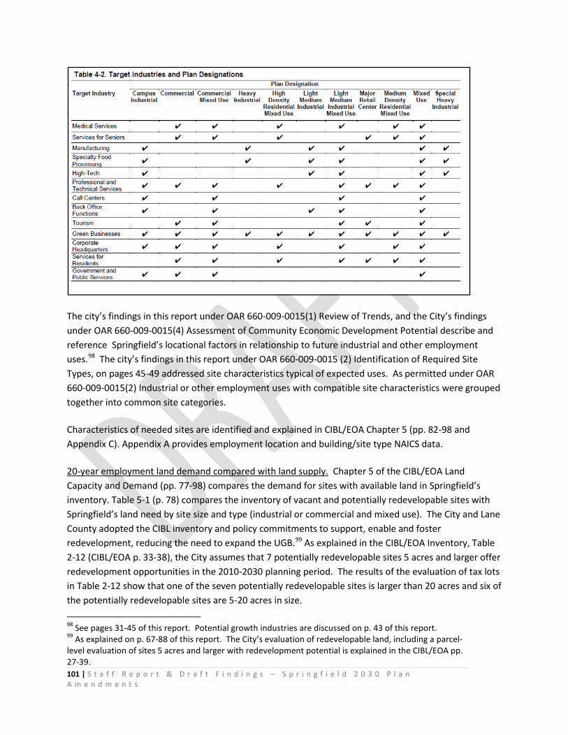
101 | S t a f f R e p o r t & D r a f t F i n d i n g s – S p r i n g f i e l d 2 0 3 0 P l a n A m e n d m e n t s
The city’s findings in this report under OAR 660-009-0015(1) Review of Trends, and the City’s findings under OAR 660-009-0015(4) Assessment of Community Economic Development Potential describe and reference Springfield’s locational factors in relationship to future industrial and other employment uses.98 The city’s findings in this report under OAR 660-009-0015 (2) Identification of Required Site Types, on pages 45-49 addressed site characteristics typical of expected uses. As permitted under OAR 660-009-0015(2) Industrial or other employment uses with compatible site characteristics were grouped together into common site categories.
Characteristics of needed sites are identified and explained in CIBL/EOA Chapter 5 (pp. 82-98 and Appendix C). Appendix A provides employment location and building/site type NAICS data.
20-year employment land demand compared with land supply. Chapter 5 of the CIBL/EOA Land Capacity and Demand (pp. 77-98) compares the demand for sites with available land in Springfield’s inventory. Table 5-1 (p. 78) compares the inventory of vacant and potentially redevelopable sites with Springfield’s land need by site size and type (industrial or commercial and mixed use). The City and Lane County adopted the CIBL inventory and policy commitments to support, enable and foster redevelopment, reducing the need to expand the UGB.99 As explained in the CIBL/EOA Inventory, Table 2-12 (CIBL/EOA p. 33-38), the City assumes that 7 potentially redevelopable sites 5 acres and larger offer redevelopment opportunities in the 2010-2030 planning period. The results of the evaluation of tax lots in Table 2-12 show that one of the seven potentially redevelopable sites is larger than 20 acres and six of the potentially redevelopable sites are 5-20 acres in size. 98 See pages 31-45 of this report. Potential growth industries are discussed on p. 43 of this report. 99 As explained on p. 67-88 of this report. The City’s evaluation of redevelopable land, including a parcel-level evaluation of sites 5 acres and larger with redevelopment potential is explained in the CIBL/EOA pp. 27-39.
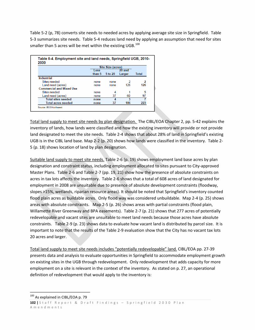
102 | S t a f f R e p o r t & D r a f t F i n d i n g s – S p r i n g f i e l d 2 0 3 0 P l a n A m e n d m e n t s
Table 5-2 (p, 78) converts site needs to needed acres by applying average site size in Springfield. Table 5-3 summarizes site needs. Table 5-4 reduces land need by applying an assumption that need for sites smaller than 5 acres will be met within the existing UGB.100
Total land supply to meet site needs by plan designation. The CIBL/EOA Chapter 2, pp. 5-42 explains the inventory of lands, how lands were classified and how the existing inventory will provide or not provide land designated to meet the site needs. Table 2-4 shows that about 28% of land in Springfield’s existing UGB is in the CIBL land base. Map 2-2 (p. 20) shows how lands were classified in the inventory. Table 2-5 (p. 18) shows location of land by plan designation.
Suitable land supply to meet site needs. Table 2-6 (p. 19) shows employment land base acres by plan designation and constraint status, including employment allocated to sites pursuant to City-approved Master Plans. Table 2-6 and Table 2-7 (pp. 19, 21) show how the presence of absolute constraints on acres in tax lots affects the inventory. Table 2-6 shows that a total of 608 acres of land designated for employment in 2008 are unsuitable due to presence of absolute development constraints (floodway, slopes >15%, wetlands, riparian resource areas). It should be noted that Springfield’s inventory counted flood plain acres as buildable acres. Only flood way was considered unbuildable. Map 2-4 (p. 25) shows areas with absolute constraints. Map 2-5 (p. 26) shows areas with partial constraints (flood plain, Willamette River Greenway and BPA easements). Table 2-7 (p. 21) shows that 277 acres of potentially redevelopable and vacant sites are unsuitable to meet land needs because those acres have absolute constraints. Table 2-9 (p. 23) shows data to evaluate how vacant land is distributed by parcel size. It is important to note that the results of the Table 2-9 evaluation show that the City has no vacant tax lots 20 acres and larger.
Total land supply to meet site needs includes “potentially redevelopable” land. CIBL/EOA pp. 27-39 presents data and analysis to evaluate opportunities in Springfield to accommodate employment growth on existing sites in the UGB through redevelopment. Only redevelopment that adds capacity for more employment on a site is relevant in the context of the inventory. As stated on p. 27, an operational definition of redevelopment that would apply to the inventory is:
100 As explained in CIBL/EOA p. 79

103 | S t a f f R e p o r t & D r a f t F i n d i n g s – S p r i n g f i e l d 2 0 3 0 P l a n A m e n d m e n t s
“Redevelopment is development that occurs on a tax lot that creates more employment space or capacity that the current use, and thus an increase in density of a tax lot.”
The rationale and criteria employed by ECONorthwest to classify sites as potentially redevelopable is explained in CIBL/EOA pp. 27-31. The public process used to inform criteria selection and application is fully documented in the record. Table 2-10 shows results of applying the criteria to tax lots in the land base. These results were evaluated and it was determined that the significant amount of land in the “lower potential” category (28% of the City’s total employment land base and more than 20% of Springfield’s covered employment —7,107 jobs) suggested limited redevelopment potential to replace existing uses with uses with more employment. As explained on in CIBL/EOA page 30:
“…land that has more employment on it, and/or higher improvement value is already in a higher use. The economics of real estate development make it less desirable to redevelop land with substantial employment on it — in large part because it has tenants that are paying leases. Thus, the “lower potential” category is not included as part of the redevelopable base.”
The City explained the criteria used to categorize and rationale used to identify potentially redevelopable land. The City’s explanation is reasonable and based on the professional judgment of the City’s consultant ECONorthwest, with input from the public, Planning Commission and City Council.
Conclusions OAR 660-009-0025(1) and (2): The 2030 Plan amendments identify the approximate number, acreage and site characteristics of sites needed to accommodate industrial and other employment uses to implement plan policies. The 2030 Plan amendments designate serviceable land suitable to meet the identified site needs, including land to meet the needs of uses with special siting characteristics identified in OAR 660-009-0025(8). The 2030 Plan amendments designate serviceable land consistent with the policy direction found in the CIBL/EOA and Comprehensive Plan. The total acreage of land designated is at least equal to the total projected land needs for each industrial or other employment use category identified in the plan during the 20-year planning period.
After accounting for available land supply and the results of efficiency measures, Table 5-4 of the CIBL/EOA identifies employment needs that require expansion of the UGB as follows:
Commercial and Mixed-Use (Land Need = 5 sites, 97 acres). After accounting for vacant, partially-vacant and potentially redevelopable commercial and mixed use land supply within the UGB, there is an unmet need for 5 commercial and mixed-use sites totaling an estimated 97 acres.
Industrial (Land Need = 2 sites, 126 acres). After accounting for vacant, partially-vacant and potentially redevelopable industrial land supply within the UGB, unmet industrial need is identified as 2 large sites, totaling an estimated 126 acres.
Total land needed in the UGB expansion of 223 suitable acres: 3 sites larger than 20 acres and 4 sites 5-20 acres.

104 | S t a f f R e p o r t & D r a f t F i n d i n g s – S p r i n g f i e l d 2 0 3 0 P l a n A m e n d m e n t s
The sites needed in the UGB expansion to meet special site needs meet the site requirements described on pages 82-95 of the CIBL/EOA Characteristics of Needed Sites.
OAR 660-009-0025 (3) Short-Term Supply of Land
“Plans for cities and counties within a Metropolitan Planning Organization or cities and counties that adopt policies relating to the short-term supply of land must designate suitable land to respond to economic development opportunities as they arise. Cities and counties may maintain the short-term supply of land according to the strategies adopted pursuant to OAR 660-009-0020(2).”
(a) Except as provided for in subsections (b) and (c), cities and counties subject to this section must provide at least 25 percent of the total land supply within the urban growth boundary designated for industrial and other employment uses as short-term supply.
(b) Affected cities and counties that are unable to achieve the target in subsection (a) above may set an alternative target based on their economic opportunities analysis.
OAR 660-009-0020 (1)(b) and OAR 660-009-0025 (3) Conclusion: The CIBL/EOA provides an analysis of short-term supply on pages 40-41 to demonstrate that most of Springfield’s land supply within the existing UGB (91% of vacant commercial and industrial land and 85% of land with redevelopment potential) is considered short-term supply because land can be ready for construction within one year based on “engineering feasibility.” Thus the short-term supply meets and exceeds the 25% threshold of OAR 660-009-0025 (3)(a). The City and Lane County adopted Economic Element Policy E.5 to state commitment to providing a competitive short-term supply of land to accommodate industrial and other employment uses it selected through the economic opportunities analysis.
OAR 660-009-0025(4)
“Subsequent implementation of or amendments to the comprehensive plan or the public facility plan that change the supply of serviceable land are not subject to the requirements of this section.”
(a) “Identify serviceable industrial and other employment sites. The affected city or county in consultation with the local service provider, if applicable, must make decisions about whether a site is serviceable. Cities and counties are encouraged to develop specific criteria for deciding whether or not a site is serviceable. Cities and counties are strongly encouraged to also consider whether or not extension of facilities is reasonably likely to occur considering the size and type of uses likely to occur and the cost or distance of facility extension;”
105 | S t a f f R e p o r t & D r a f t F i n d i n g s – S p r i n g f i e l d 2 0 3 0 P l a n A m e n d m e n t s
The City’s 2030 Plan amendments to the Metro Plan comprehensive plan change the supply of serviceable land and thus are not subject to the requirements of OAR 660-009-0025(4). Though not required to do so, the City conducted a considerable amount of comparative analysis to identify serviceable industrial and other employment sites, with the intent of providing suitable, serviceable lands in the near term to meet its economic development objectives.
As explained in the CIBL/EOA Inventory and discussion of development constraints in Chapter 2 (pp. 8-17), and as documented in the record, the City consulted with local service providers to make decisions about whether a site is serviceable. As fully explained in the City’s findings under Goal 14 Public Facilities Analyses, the City consulted with local service providers to make decisions about whether a site is serviceable; developed specific criteria for deciding whether or not a site is serviceable; and considered whether or not extension of facilities is reasonably likely to occur considering the size and type of uses likely to occur and the cost or distance of facility extension.
OAR 660-009-0025(5) Institutional Uses
“Cities and counties are not required to designate institutional uses on privately owned land when implementing section (2) of this rule. Cities and counties may designate land in an industrial or other employment land category to compensate for any institutional land demand that is not designated under this section.”
As permitted under OAR 660-009-0025 (5) Cities and counties may designate land in an industrial or other employment land category to compensate for any institutional land demand that is not designated under this section.
OAR 660-009-0025 (6) Compatibility.
“Cities and counties are strongly encouraged to manage encroachment and intrusion of uses incompatible with industrial and other employment uses. Strategies for managing encroachment and intrusion of incompatible uses include, but are not limited to, transition areas around uses having negative impacts on surrounding areas, design criteria, district designation, and limiting non-essential uses within districts.”
The Springfield Development Code includes district designations, use limitations and development standards to address land use compatibility. These include requirements for landscaped setbacks between zoning districts, design criteria for Campus Industrial, Nodal Development, Mixed Use Employment and Mixed Use Commercial plan designations and zoning districts.
The 2030 Plan amendments establish the AG land use zoning district (Ordinance Exhibit E) to support transition of land from rural agriculture uses to urban employment uses — including provisions to limit interim development on lands added to the UGB to meet large site employment needs. The AG
106 | S t a f f R e p o r t & D r a f t F i n d i n g s – S p r i n g f i e l d 2 0 3 0 P l a n A m e n d m e n t s
development standards manage encroachment in the Urban Holding Area – Employment plan designation by prohibiting intrusion of incompatible uses.101
OAR 660-009-0025(7) Availability
“Cities and counties may consider land availability when designating the short-term supply of land. Available land is vacant or developed land likely to be on the market for sale or lease at prices consistent with the local real estate market. Methods for determining lack of availability include, but are not limited to…
The City did not consider land availability when designating the short-term supply of land. CIBL/EOA (page 40-41, Table 2-13) provides an analysis of short-term supply of land. For purposes of Goal 9, the City assumes 91% of the vacant buildable land acres designated for employment uses and 85% of land with redevelopment potential within the existing UGB is available as short-term supply. Buildable land in the Jasper-Natron area is the only area with employment lands that are not considered part of the short term supply.
OAR 660-009-0025(8) Uses with Special Siting Characteristics
“Cities and counties that adopt objectives or policies providing for uses with special site needs must adopt policies and land use regulations providing for those special site needs. Special site needs include, but are not limited to large acreage sites, special site configurations, direct access to transportation facilities, prime industrial lands, sensitivity to adjacent land uses, or coastal shoreland sites designated as suited for water-dependent use under Goal 17. Policies and land use regulations for these uses must:
(a) Identify sites suitable for the proposed use;
(b) Protect sites suitable for the proposed use by limiting land divisions and permissible uses and activities that interfere with development of the site for the intended use; and
(c) Where necessary, protect a site for the intended use by including measures that either prevent or appropriately restrict incompatible uses on adjacent and nearby lands.
OAR 660-024-0050(6) Plan designations and zoning
“When land is added to the UGB, the local government must assign appropriate urban plan designations to the added land, consistent with the need determination. The local government must also apply appropriate zoning to the added land consistent with the
101 As cited on page 112-113 of this report, Exhibit E, SDC 3.2-915, Table A.

107 | S t a f f R e p o r t & D r a f t F i n d i n g s – S p r i n g f i e l d 2 0 3 0 P l a n A m e n d m e n t s
plan designation or may maintain the land as urbanizable land until the land is rezoned for the planned urban uses, either by retaining the zoning that was assigned prior to inclusion in the boundary or by applying other interim zoning that maintains the land's potential for planned urban development. The requirements of ORS 197.296 regarding planning and zoning also apply when local governments specified in that statute add land to the UGB.”
Special site needs and characteristics. The City’s CIBL/EOA identifies a need for suitable employment land to accommodate uses with “special siting characteristics,”102 thus OAR 660-009-0025(8) is applicable.
The City’s CIBL/EOA identifies a need for suitable employment land to accommodate uses with special site needs identified in OAR 660-009-0025(8) including but not limited to:
o large acreage sites o special site configurations o direct access to transportation facilities o prime industrial lands o sensitivity to adjacent land uses
The Administrative Rule defines site characteristics as follows in OAR 660-009-0005(11):
“"Site Characteristics" means the attributes of a site necessary for a particular industrial or other employment use to operate. Site characteristics include, but are not limited to, a minimum acreage or site configuration including shape and topography, visibility, specific types or levels of public facilities, services or energy infrastructure, or proximity to a particular transportation or freight facility such as rail, marine ports and airports, multimodal freight or transshipment facilities, and major transportation routes.”
Minimum acreage/Large acreage sites. The City’s CIBL inventory of Industrial and Other Employment Lands indicates that Springfield has a deficit of suitable sites that are 20 acres and larger, and deficit of sites 5-20 acres in size. After assuming that all site needs for commercial and industrial uses that require sites smaller than 5 acres would be addressed through redevelopment103, CIBL/EOA Table 5-4, (p. 80) shows a deficit of 2 industrial sites and 1 commercial and mixed use site 20 acres and larger. Table 5-2 (p. 78) shows the average site size in Springfield for industrial and commercial and mixed use sites 20 acres and larger: 63 acres and 60 acres respectively. Thus Springfield has a need for 126 acres of
102 CIBL/EOA pp. 82-98 identifies target large-scale manufacturers and large office employers that require sites with special characteristics including : site size 20 acres and larger, topography less 5 % / 7%, transportation access as close to I-5 as possible via unimpeded freight route, access to public facilities and services, and sites with two or fewer owners. 103 CIBL/EOA Table 5-1, p. 78 shows that 188 industrial sites and 340 commercial and mixed use sites would redevelop to address land needs over the 20-year period. In addition to this assumption, Springfield concludes that all land needs on sites smaller than 5 acres would be accommodated through redevelopment, including the 6-acre deficit of 2-5 acre sites shown in Table 5-3, p. 79.
108 | S t a f f R e p o r t & D r a f t F i n d i n g s – S p r i n g f i e l d 2 0 3 0 P l a n A m e n d m e n t s
industrial employment land on 2 sites larger than 20 acres and a need for 97 acres of commercial employment land on 5 sites, including one site that is 60 acres in size.
The CIBL/EOA presents the range of typical site size attributes of Springfield’s target employers in the manufacturing category on p. 84-90 and in the large office category on p. 90-95.
Identification of large acreage sites suitable for the proposed use. The City and Lane County amended the Springfield UGB to provide at least 223 suitable acres of employment land to meet the City’s employment land needs for suitable sites larger than 5 acres. OAR 660-009-0025(8) requires the City to identify the lands to accommodate the proposed uses. The sites are identified in Ordinance Exhibit A-2 as “North Gateway” site and “Mill Race” site and are described in Ordinance Exhibit C-1 Urbanization Element and Exhibit D Metro Plan text amendment” Urban Holding Area – Employment Plan Designation.
Protection of sites suitable for the proposed use. OAR 660-009-0025(8) requires the City to adopt land use regulations limiting land divisions and permissible uses and activities that interfere with development of the site for the intended use, and “where necessary, protect a site for the intended use by including measures that either prevent or appropriately restrict incompatible uses on adjacent and nearby lands.” The City and Lane County adopted Ordinance Exhibit E amending the Springfield Development Code to establish SDC 3.2-900: the “Agriculture – Urban Holding Area (AG)” land use zoning district; and Exhibit A-3 applying the AG zone to the Urban Holding Area - Employment sites.
The AG District implements the Urban Holding Area-Employment (UHA-E) plan designation and Springfield Comprehensive Plan Urbanization Element policies by preserving an inventory of suitable employment sites — including sites 20 acres and larger — to provide opportunities for economic growth and diversification. The AG District is applied concurrently with the UHA-E designation at the time of the subject Springfield Urban Growth Boundary (UGB) amendment and remains in effect until the land is designated and zoned for urban employment uses through a City or owner-initiated plan or zoning amendment process, as described in Subsection 3.2-930 Planning Requirements Applicable to Zoning Map Amendments, and as further described in the Springfield Comprehensive Plan Urbanization Element.
The AG District protects urbanizable lands designated UHA-E in the comprehensive plan from land division and incompatible interim development. The AG regulatory measures guide and support orderly and efficient transition from rural to urban land use to accommodate population and urban employment inside the UGB. AG standards regulate development to maintain the land’s potential for planned future urban development until appropriate urban facilities and services are planned or available and annexation to Springfield can occur, as described in the Springfield Comprehensive Plan Urbanization Element. Land designated Urban Holding Area-Employment will be annexed to the city and rezoned from AG to an appropriate industrial or commercial zone at which time urban industrial and other employment uses will supersede the interim rural uses permitted in the AG District.

109 | S t a f f R e p o r t & D r a f t F i n d i n g s – S p r i n g f i e l d 2 0 3 0 P l a n A m e n d m e n t s
Special site configuration including shape and topography. The CIBL/EOA presents the typical site configuration and topography attributes of Springfield’s target employers in the manufacturing category and in the large office category.
The employment site needs analysis in CIBL/EOA Chapter 4 identified site needs in five types of buildings: warehousing and distribution, general industrial, office, retail, and other services. The characteristics of needed sites for each of these building types are described in CIBL/EOA Chapter 5. All sites will need access to electricity, phone, and high-speed telecommunications.
OAR 660-009-0005(11) defines “minimum acreage or site configuration” as an attribute of a site that may be necessary for a particular industrial or other employment use to operate.
Springfield’s analysis identified a need for sites larger than 5 acres and sites larger than 20 acres. Table 5-1 shows that Springfield has a deficit of two Industrial sites 20 acres and larger, which may be needed by target industries such as light manufacturing, high-tech manufacturing, recreation equipment manufacturing, wood products manufacturing, medical products manufacturing, alternative energy manufacturing, or specialty food processing.
Springfield also has a deficit of Commercial and Mixed Use sites, including: four sites 5 to 20 acres in size and one site 20 acres and larger. The target industries that may locate on these sites include: Medical Services, Professional and Technical Services, Back-Office Functions, Call Centers, or Corporate Headquarters.
CIBL/EOA pages 82-98 present the characteristics of needed sites, focusing on the deficit of 223 acres of employment land identified in Table 5-4104:
OAR 660-009-0005(11) defines “shape and topography” as attributes of a site that may be necessary for a particular industrial or other employment use to operate.
104 CIBL/EOA, p. 80

110 | S t a f f R e p o r t & D r a f t F i n d i n g s – S p r i n g f i e l d 2 0 3 0 P l a n A m e n d m e n t s
OAR 660-009-0005(11) defines “visibility” as an attribute of a site that may be necessary for a particular industrial or other employment use to operate. The City’s UGB expansion includes land visible from Interstate Highway 5.
OAR 660-009-0005(11) defines “specific types or levels of public facilities, services or infrastructure” as attributes of a site that may be necessary for a particular industrial or other employment use to operate. The City expanded the UGB to include land that can be served with urban levels of public facilities, services or infrastructure.105
OAR 660-009-0005(11) defines “proximity to a particular transportation or freight facility such as rail, marine ports and airports, multimodal freight or transshipment facilities, and major transportation routes” as attributes of a site that may be necessary for a particular industrial or other employment use to operate. The City expanded the UGB to include land that is located proximate to major transportation routes. The North Gateway site is within 1 mile of Interstate Highway 5. The Mill Race site is within ½ mile of Oregon Highway 126, and accessible to truck routes.
The OAR 660-009-0005(11) definition of “site characteristics” states that the characteristics listed in the definition “include, but are not limited to” the characteristics listed in the definition, thus other characteristics — such as proximity to existing or planned public transit routes may be necessary siting criteria for major employers and may be necessary to achieve local and regional transportation, land use, and equity policy objectives.
The City’s identification of needed site characteristics is reasonable, explained by evidence in the CIBL/EOA and evidence in the record, and consistent with the Goal 9 administrative rule.
CIBL/EOA presents information about the sites needed by the target industries based on information by Business Oregon, economic development efforts in Springfield, a study about industry site needs in Springfield by Tadzo, and other sources. Appendix C (Tables C-6 to C-11) present details of research about site needs of Springfield’s target industries from these sources. CIBL/EOA Table 5-5106 provides a summary of site characteristics of sites needed by Springfield’s target industries:
105 See City’s complete findings under Goal 14 Public Facilities Analysis 106 ECONorthwest, CIBL/EOA, page 84
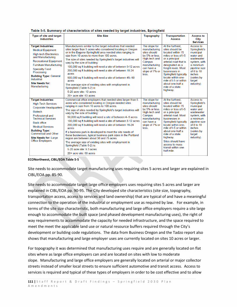
111 | S t a f f R e p o r t & D r a f t F i n d i n g s – S p r i n g f i e l d 2 0 3 0 P l a n A m e n d m e n t s
ECONorthwest, CIBL/EOA Table 5-5
Site needs to accommodate target manufacturing uses requiring sites 5 acres and larger are explained in CIBL/EOA pp. 85-90.
Site needs to accommodate target large office employers uses requiring sites 5 acres and larger are explained in CIBL/EOA pp. 90-95. The City developed site characteristics (site size, topography, transportation access, access to services and land ownership) that are typical of and have a meaningful connection to the operation of the industrial or employment use as required by law. For example, in terms of the site size characteristic, both manufacturing and large office employers require a site large enough to accommodate the built space (and phased development manufacturing uses), the right of way requirements to accommodate the capacity for needed infrastructure, and the space required to meet the meet the applicable land use or natural resource buffers required through the City’s development or building code regulations. The data from Business Oregon and the Tadzo report also shows that manufacturing and large employer uses are currently located on sites 10 acres or larger.
For topography it was determined that manufacturing uses require and are generally located on flat sites where as large office employers can and are located on sites with low to moderate slope. Manufacturing and large office employers are generally located on arterial or major collector streets instead of smaller local streets to ensure sufficient automotive and transit access. Access to services is required and typical of these types of employers in order to be cost effective and to allow
112 | S t a f f R e p o r t & D r a f t F i n d i n g s – S p r i n g f i e l d 2 0 3 0 P l a n A m e n d m e n t s
manufacturing industries access to services such as water and wastewater. The land ownership site characteristic is connected to the operation of manufacturing and large office employers because the extra time and cost of developing an industrial site with multiple landowners can often make a development infeasible. Also, OAR 660-009-0005(2) specifically lists parcel fragmentation as a development constraint.
The City and Lane County adopted policies in the 2030 Comprehensive Plan Urbanization Element and land use regulations in the Springfield Development Code107 to protect sites 20 acres and larger from land division in order to accommodate uses that require sites 20 acres and larger.
Metro Plan IV-4, Policy 11 states:
“Local implementing ordinances shall provide a process for zoning lands in conformance with the Metro Plan.”
The 2030 Plan includes amendments to the Metro Plan Diagram and text, Springfield Zoning Map and Springfield Development Code to establish areas of the City where employment land uses can occur to provide sites of suitable sizes, types and locations within proposed North Gateway and Mill Race UGB expansion areas.
The 2030 Plan relies on existing acknowledged Metro Plan designations and Springfield Development Code zoning districts to identify areas of the City where employment land uses are permitted to provide sites of suitable sizes, types and locations within the existing UGB.
The 2030 Plan Ordinance Exhibit D amends the Metro Plan to establish the Urban Holding Area – Employment (UHA-E) Metro Plan designation, described in the amended Metro Plan text page II-G-8 as follows:
Urban Holding Area – Employment
Lands brought into Springfield’s UGB to address 2010-2030 land needs for large employment sites are designated Urban Holding Area – Employment (UHA-E) as an interim designation to maintain the land’s potential for planned urban development until appropriate urban facilities and services are planned or available and annexation to Springfield can occur. Lands within the UHA-E designation are zoned Agriculture to retain large parcels sizes and current predominant farm use. The UHA-E designation remains in effect until the appropriate Employment designation is adopted through a City refinement plan process or owner-initiated plan amendment process, and when land is master planned, annexed and zoned to allow site development with employment uses. A 50-acre minimum lot size is applied to ownerships of 50 or more acres and a 20-acre minimum lot size is applied to ownerships of 20 to 50 acres to protect undeveloped sites from piecemeal development until a site development plan has been approved.
107 See Ordinance _____, Exhibit E: SDC 3.2-900 Agriculture- Urban Holding Area (AG) Zoning District
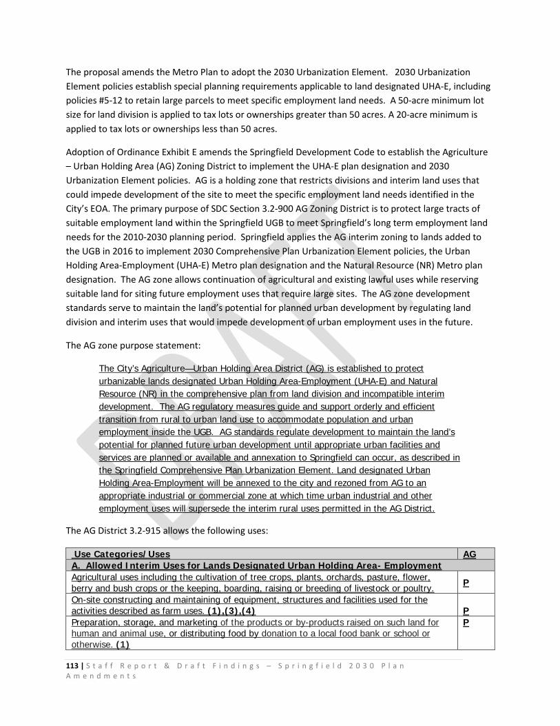
113 | S t a f f R e p o r t & D r a f t F i n d i n g s – S p r i n g f i e l d 2 0 3 0 P l a n A m e n d m e n t s
The proposal amends the Metro Plan to adopt the 2030 Urbanization Element. 2030 Urbanization Element policies establish special planning requirements applicable to land designated UHA-E, including policies #5-12 to retain large parcels to meet specific employment land needs. A 50-acre minimum lot size for land division is applied to tax lots or ownerships greater than 50 acres. A 20-acre minimum is applied to tax lots or ownerships less than 50 acres.
Adoption of Ordinance Exhibit E amends the Springfield Development Code to establish the Agriculture – Urban Holding Area (AG) Zoning District to implement the UHA-E plan designation and 2030 Urbanization Element policies. AG is a holding zone that restricts divisions and interim land uses that could impede development of the site to meet the specific employment land needs identified in the City’s EOA. The primary purpose of SDC Section 3.2-900 AG Zoning District is to protect large tracts of suitable employment land within the Springfield UGB to meet Springfield’s long term employment land needs for the 2010-2030 planning period. Springfield applies the AG interim zoning to lands added to the UGB in 2016 to implement 2030 Comprehensive Plan Urbanization Element policies, the Urban Holding Area-Employment (UHA-E) Metro plan designation and the Natural Resource (NR) Metro plan designation. The AG zone allows continuation of agricultural and existing lawful uses while reserving suitable land for siting future employment uses that require large sites. The AG zone development standards serve to maintain the land’s potential for planned urban development by regulating land division and interim uses that would impede development of urban employment uses in the future.
The AG zone purpose statement:
The City’s Agriculture—Urban Holding Area District (AG) is established to protect urbanizable lands designated Urban Holding Area-Employment (UHA-E) and Natural Resource (NR) in the comprehensive plan from land division and incompatible interim development. The AG regulatory measures guide and support orderly and efficient transition from rural to urban land use to accommodate population and urban employment inside the UGB. AG standards regulate development to maintain the land’s potential for planned future urban development until appropriate urban facilities and services are planned or available and annexation to Springfield can occur, as described in the Springfield Comprehensive Plan Urbanization Element. Land designated Urban Holding Area-Employment will be annexed to the city and rezoned from AG to an appropriate industrial or commercial zone at which time urban industrial and other employment uses will supersede the interim rural uses permitted in the AG District.
The AG District 3.2-915 allows the following uses:
Use Categories/Uses AG A. Allowed Interim Uses for Lands Designated Urban Holding Area- Employment Agricultural uses including the cultivation of tree crops, plants, orchards, pasture, flower, berry and bush crops or the keeping, boarding, raising or breeding of livestock or poultry. P
On-site constructing and maintaining of equipment, structures and facilities used for the activities described as farm uses. (1),(3),(4)
P
Preparation, storage, and marketing of the products or by-products raised on such land for human and animal use, or distributing food by donation to a local food bank or school or otherwise. (1)
P
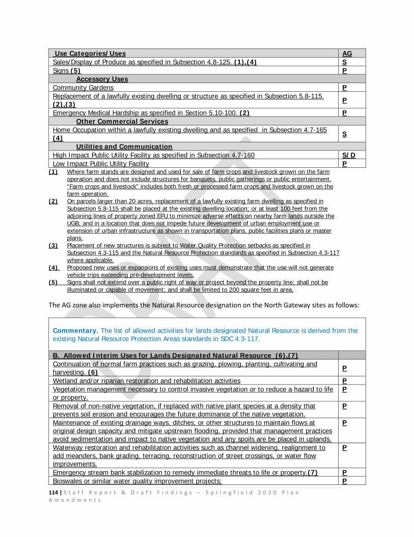
114 | S t a f f R e p o r t & D r a f t F i n d i n g s – S p r i n g f i e l d 2 0 3 0 P l a n A m e n d m e n t s
Use Categories/Uses AG Sales/Display of Produce as specified in Subsection 4.8-125. (1),(4) S Signs (5) P
Accessory Uses Community Gardens P Replacement of a lawfully existing dwelling or structure as specified in Subsection 5.8-115. (2),(3) P
Emergency Medical Hardship as specified in Section 5.10-100. (2) P Other Commercial Services
Home Occupation within a lawfully existing dwelling and as specified in Subsection 4.7-165 (4) S
Utilities and Communication High Impact Public Utility Facility as specified in Subsection 4.7-160 S/D Low Impact Public Utility Facility P
(1) Where farm stands are designed and used for sale of farm crops and livestock grown on the farm operation and does not include structures for banquets, public gatherings or public entertainment. “Farm crops and livestock” includes both fresh or processed farm crops and livestock grown on the farm operation.
(2) On parcels larger than 20 acres, replacement of a lawfully existing farm dwelling as specified in Subsection 5.8-115 shall be placed at the existing dwelling location; or at least 100 feet from the adjoining lines of property zoned EFU to minimize adverse effects on nearby farm lands outside the UGB; and in a location that does not impede future development of urban employment use or extension of urban infrastructure as shown in transportation plans, public facilities plans or master plans.
(3) Placement of new structures is subject to Water Quality Protection setbacks as specified in Subsection 4.3-115 and the Natural Resource Protection standards as specified in Subsection 4.3-117 where applicable.
(4) Proposed new uses or expansions of existing uses must demonstrate that the use will not generate vehicle trips exceeding pre-development levels.
(5) Signs shall not extend over a public right of way or project beyond the property line; shall not be illuminated or capable of movement; and shall be limited to 200 square feet in area.
The AG zone also implements the Natural Resource designation on the North Gateway sites as follows:
Commentary. The list of allowed activities for lands designated Natural Resource is derived from the existing Natural Resource Protection Areas standards in SDC 4.3-117. B. Allowed Interim Uses for Lands Designated Natural Resource (6),(7) Continuation of normal farm practices such as grazing, plowing, planting, cultivating and harvesting. (6) P
Wetland and/or riparian restoration and rehabilitation activities P Vegetation management necessary to control invasive vegetation or to reduce a hazard to life or property.
P
Removal of non-native vegetation, if replaced with native plant species at a density that prevents soil erosion and encourages the future dominance of the native vegetation.
P
Maintenance of existing drainage ways, ditches, or other structures to maintain flows at original design capacity and mitigate upstream flooding, provided that management practices avoid sedimentation and impact to native vegetation and any spoils are be placed in uplands.
P
Waterway restoration and rehabilitation activities such as channel widening, realignment to add meanders, bank grading, terracing, reconstruction of street crossings, or water flow improvements.
P
Emergency stream bank stabilization to remedy immediate threats to life or property.(7) P Bioswales or similar water quality improvement projects; P
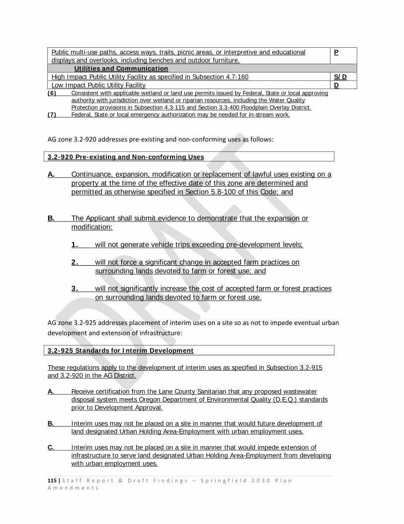
115 | S t a f f R e p o r t & D r a f t F i n d i n g s – S p r i n g f i e l d 2 0 3 0 P l a n A m e n d m e n t s
Public multi-use paths, access ways, trails, picnic areas, or interpretive and educational displays and overlooks, including benches and outdoor furniture.
P
Utilities and Communication High Impact Public Utility Facility as specified in Subsection 4.7-160 S/D Low Impact Public Utility Facility D
(6) Consistent with applicable wetland or land use permits issued by Federal, State or local approving authority with jurisdiction over wetland or riparian resources, including the Water Quality Protection provisions in Subsection 4.3-115 and Section 3.3-400 Floodplain Overlay District.
(7) Federal, State or local emergency authorization may be needed for in-stream work.
AG zone 3.2-920 addresses pre-existing and non-conforming uses as follows:
3.2-920 Pre-existing and Non-conforming Uses A. Continuance, expansion, modification or replacement of lawful uses existing on a
property at the time of the effective date of this zone are determined and permitted as otherwise specified in Section 5.8-100 of this Code; and
B. The Applicant shall submit evidence to demonstrate that the expansion or
modification: 1. will not generate vehicle trips exceeding pre-development levels; 2. will not force a significant change in accepted farm practices on
surrounding lands devoted to farm or forest use; and 3. will not significantly increase the cost of accepted farm or forest practices
on surrounding lands devoted to farm or forest use.
AG zone 3.2-925 addresses placement of interim uses on a site so as not to impede eventual urban development and extension of infrastructure:
3.2-925 Standards for Interim Development These regulations apply to the development of interim uses as specified in Subsection 3.2-915 and 3.2-920 in the AG District. A. Receive certification from the Lane County Sanitarian that any proposed wastewater
disposal system meets Oregon Department of Environmental Quality (D.E.Q.) standards prior to Development Approval.
B. Interim uses may not be placed on a site in manner that would future development of
land designated Urban Holding Area-Employment with urban employment uses. C. Interim uses may not be placed on a site in manner that would impede extension of
infrastructure to serve land designated Urban Holding Area-Employment from developing with urban employment uses.
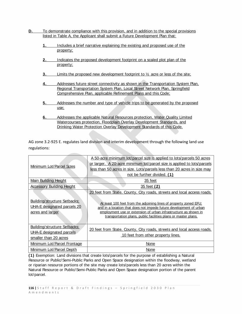
116 | S t a f f R e p o r t & D r a f t F i n d i n g s – S p r i n g f i e l d 2 0 3 0 P l a n A m e n d m e n t s
D. To demonstrate compliance with this provision, and in addition to the special provisions listed in Table A, the Applicant shall submit a Future Development Plan that:
1. Includes a brief narrative explaining the existing and proposed use of the
property; 2. Indicates the proposed development footprint on a scaled plot plan of the
property; 3. Limits the proposed new development footprint to ½ acre or less of the site; 4. Addresses future street connectivity as shown in the Transportation System Plan,
Regional Transportation System Plan, Local Street Network Plan, Springfield Comprehensive Plan, applicable Refinement Plans and this Code;
5. Addresses the number and type of vehicle trips to be generated by the proposed
use; 6. Addresses the applicable Natural Resources protection, Water Quality Limited
Watercourses protection, Floodplain Overlay Development Standards, and Drinking Water Protection Overlay Development Standards of this Code.
AG zone 3.2-925 E. regulates land division and interim development through the following land use regulations:
Minimum Lot/Parcel Sizes
A 50-acre minimum lot/parcel size is applied to lots/parcels 50 acres or larger. A 20-acre minimum lot/parcel size is applied to lots/parcels less than 50 acres in size. Lots/parcels less than 20 acres in size may
not be further divided. (1) Main Building Height 35 feet Accessory Building Height 35 feet (2)
Building/structure Setbacks: UHA-E designated parcels 20 acres and larger
20 feet from State, County, City roads, streets and local access roads.
At least 100 feet from the adjoining lines of property zoned EFU; and in a location that does not impede future development of urban employment use or extension of urban infrastructure as shown in
transportation plans, public facilities plans or master plans.
Building/structure Setbacks: UHA-E designated parcels smaller than 20 acres
20 feet from State, County, City roads, streets and local access roads. 10 feet from other property lines.
Minimum Lot/Parcel Frontage None Minimum Lot/Parcel Depth None
(1) Exemption: Land divisions that create lots/parcels for the purpose of establishing a Natural Resource or Public/Semi-Public Parks and Open Space designation within the floodway, wetland or riparian resource portions of the site may create lots/parcels less than 20 acres within the Natural Resource or Public/Semi-Public Parks and Open Space designation portion of the parent lot/parcel.
117 | S t a f f R e p o r t & D r a f t F i n d i n g s – S p r i n g f i e l d 2 0 3 0 P l a n A m e n d m e n t s
(2) Water tanks, silos, granaries, barns and similar accessory structures or necessary mechanical appurtenances may exceed the minimum height standard.
It should be noted that the AG zone, when acknowledged, will be in effect for land currently zoned Exclusive Farm Use (EFU) by Lane County. The property subject to the AG zone is currently zoned EFU 30 and EFU 25 by Lane County, and subject to 30-acre and 25-acre minimum parcel sizes. The AG zone retains a restriction on land division to preserve large employment sites pursuant to the City’s Commercial and Industrial Buildable Lands Inventory and Economic Opportunities Analysis and 2030 Comprehensive Plan Economic Element policies.
The existing Lane County EFU Zone setback standards found in Lane County Chapter 16.212 (10)(a)(ii) require dwellings to be sited at least 100 feet from the adjoining lines of property zoned EFU “to minimize impacts upon nearby farm uses or to assure optimal siting of proposed dwellings to minimize adverse impacts on nearby farm and forest lands.” The setback standards found in Lane County Chapter 16.212 (10)(b) require 20 foot setbacks from the right of way of a State or County road or a local access public road and 10 foot setbacks from other property lines. Larger setbacks are established for riparian corridors. Other similar codes to the AG zone — such as the City of Redmond for Urban Holding-10 acre zone — require 50-foot front and rear yard setbacks and 10-foot side yard setbacks, and establish a maximum building height of 30 feet.
The City’s proposed development standards for the AG zone are reasonable and provide the level of site protection required under OAR 660-009-0025(8).
Planning procedures required prior to rezoning land from Agriculture - Urban Holding Area (AG) to urban employment zoning designations. In addition to the standards, procedures and review criteria in Section 5.22-100 applicable to Zoning Map Amendments, AG zone 3.2-930 Table 1 provides an overview of the planning procedures required prior to rezoning land from Agriculture - Urban Holding Area (AG) to urban employment zoning designations (e.g. Employment, Employment Mixed Use, Campus Industrial, or Industrial). Table 1 shows both City and Owner-initiated planning processes. 3.2-930 Planning Requirements Applicable to Zoning Map Amendments
In addition to the standards, procedures and review criteria in Section 5.22-100 applicable to Zoning Map Amendments, Table 1 provides an overview of the planning procedures required prior to rezoning land from Agriculture - Urban Holding Area (AG) to urban employment zoning designations (e.g. Employment, Employment Mixed Use, Campus Industrial, or Industrial). Table 1 shows both City and Owner-initiated planning processes.
Table 1. Pre-Development Approval Process Steps – Urban Holding Areas
City-initiated Planning Process Owner-initiated Planning Process
1. City prepares Plan Amendment to address all applicable Statewide Planning Goals (e.g. amended or new refinement plan or district plan), Metro Plan and Springfield Comprehensive Plan policies and Springfield Development Code
1. Applicant submits request to City to initiate amendments to the Transportation System Plan and Public Facilities and Services Plan, and other city actions that may be required prior to plan amendment approval.
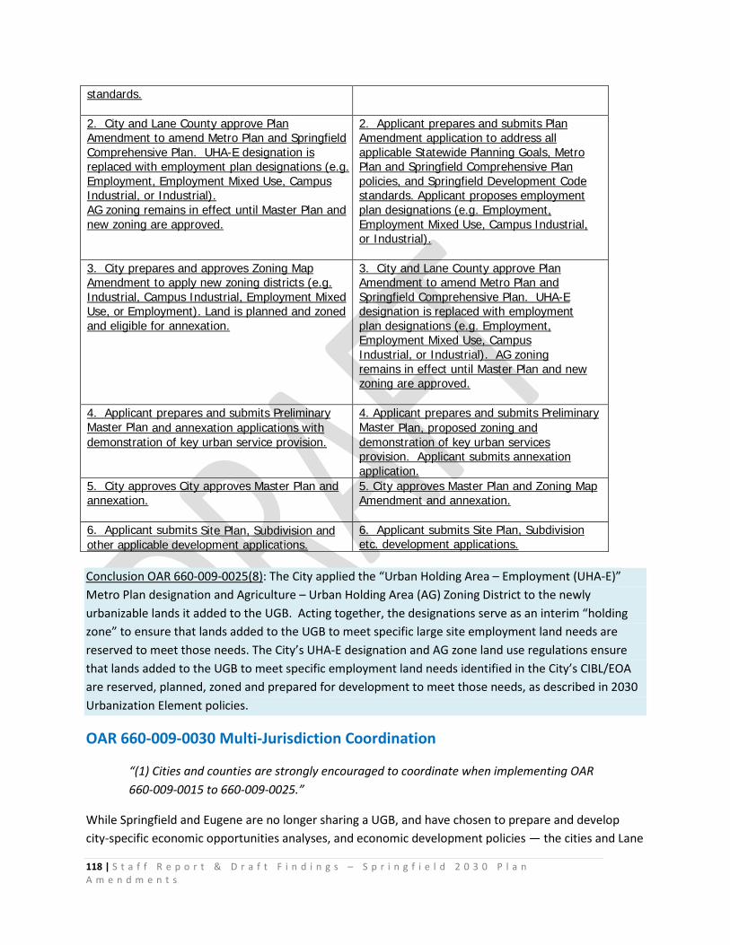
118 | S t a f f R e p o r t & D r a f t F i n d i n g s – S p r i n g f i e l d 2 0 3 0 P l a n A m e n d m e n t s
standards.
2. City and Lane County approve Plan Amendment to amend Metro Plan and Springfield Comprehensive Plan. UHA-E designation is replaced with employment plan designations (e.g. Employment, Employment Mixed Use, Campus Industrial, or Industrial). AG zoning remains in effect until Master Plan and new zoning are approved.
2. Applicant prepares and submits Plan Amendment application to address all applicable Statewide Planning Goals, Metro Plan and Springfield Comprehensive Plan policies, and Springfield Development Code standards. Applicant proposes employment plan designations (e.g. Employment, Employment Mixed Use, Campus Industrial, or Industrial).
3. City prepares and approves Zoning Map Amendment to apply new zoning districts (e.g. Industrial, Campus Industrial, Employment Mixed Use, or Employment). Land is planned and zoned and eligible for annexation.
3. City and Lane County approve Plan Amendment to amend Metro Plan and Springfield Comprehensive Plan. UHA-E designation is replaced with employment plan designations (e.g. Employment, Employment Mixed Use, Campus Industrial, or Industrial). AG zoning remains in effect until Master Plan and new zoning are approved.
4. Applicant prepares and submits Preliminary Master Plan and annexation applications with demonstration of key urban service provision.
4. Applicant prepares and submits Preliminary Master Plan, proposed zoning and demonstration of key urban services provision. Applicant submits annexation application.
5. City approves City approves Master Plan and annexation.
5. City approves Master Plan and Zoning Map Amendment and annexation.
6. Applicant submits Site Plan, Subdivision and other applicable development applications.
6. Applicant submits Site Plan, Subdivision etc. development applications.
Conclusion OAR 660-009-0025(8): The City applied the “Urban Holding Area – Employment (UHA-E)” Metro Plan designation and Agriculture – Urban Holding Area (AG) Zoning District to the newly urbanizable lands it added to the UGB. Acting together, the designations serve as an interim “holding zone” to ensure that lands added to the UGB to meet specific large site employment land needs are reserved to meet those needs. The City’s UHA-E designation and AG zone land use regulations ensure that lands added to the UGB to meet specific employment land needs identified in the City’s CIBL/EOA are reserved, planned, zoned and prepared for development to meet those needs, as described in 2030 Urbanization Element policies.
OAR 660-009-0030 Multi-Jurisdiction Coordination
“(1) Cities and counties are strongly encouraged to coordinate when implementing OAR 660-009-0015 to 660-009-0025.”
While Springfield and Eugene are no longer sharing a UGB, and have chosen to prepare and develop city-specific economic opportunities analyses, and economic development policies — the cities and Lane
119 | S t a f f R e p o r t & D r a f t F i n d i n g s – S p r i n g f i e l d 2 0 3 0 P l a n A m e n d m e n t s
County continue to partner and coordinate through regional economic development planning activities. Regional economic development initiatives are directly reflected in the Springfield 2030 Economic Element.
Goal EG-2 states:
“Support attainment of the Regional Prosperity Economic Development Plan108 goals for creating new metropolitan area jobs in the chosen economic opportunity areas, increasing the average annual wage and reducing unemployment.”
Goal EG-5 states:
“Support the development of emerging economies guided by the following principles:109
a. Healthy Living—Champion businesses and entrepreneurs that promote a healthy, safe, and clean community while enhancing, protecting, and making wise use of natural resources.
b. Ideas to Enterprise—Encourage a culture of entrepreneurship and re-investment into the local community.
c. Regional Identity—Create a strong economic personality that celebrates our region’s attributes and values.
d. Be Prepared—Contribute to development of the region’s physical, social, educational, and workforce infrastructure to meet the needs of tomorrow.
e. Local Resilience— Support businesses and entrepreneurs that lead the city and region to greater economic independence, innovation, and growth of the traded sector economies.”
Conclusion OAR 660-009-0030: Springfield, Eugene and Lane County have coordinated throughout the Metro Plan transition process and 2030 planning process, sharing information and collaborating to develop direction for the “future” Metro Plan to support respective comprehensive plans within the Eugene-Springfield Metro region.
Goal 9 Conclusion: For the reasons stated above and based on information found in the Springfield CIBL/EOA, the proposed Comprehensive Plan amendments comply with Goal 9. 108 Regional Prosperity Economic Development Plan — approved by the Springfield, Eugene and Lane County Joint Elected Officials (JEO) in February 2010 109Ibid.
120 | S t a f f R e p o r t & D r a f t F i n d i n g s – S p r i n g f i e l d 2 0 3 0 P l a n A m e n d m e n t s
V. Statewide Planning Goal 14: Urbanization Employment Land Need and Response to Deficiency
OAR 660-015-0000(14) To provide for an orderly and efficient transition from rural to urban land use, to
accommodate urban population and urban employment inside urban growth boundaries, to ensure efficient use of land, and to provide for livable communities.
OAR 660-015-0000(14), OAR 660-024-0040(1), OAR 660-024-0040(5), OAR 660-024-0050(1), and OAR 660-024-0050 (4)
The standards for amending an urban growth boundary (UGB) are found in Statewide Planning Goal 14 (Urbanization), and in ORS 197.298 Priorities for urban growth boundary amendments. The Goal 14 rule (OAR Chapter 660, Division 024) interprets and clarifies the more general language of Goal 14 and explains the relationship between statutory “priorities” and Goal 14 “location factors.” In the Goal 14 rule findings below, text shown in italic is quoted directly from the referenced goal, rule or statute.
Goal 14 describes how land needs — including employment land needs — shall form the basis for changes to UGBs: “Land Need. Establishment and change of urban growth boundaries shall be based on the following:
(1) Demonstrated need to accommodate long range urban population, consistent with a 20-year affected local governments; and (2) Demonstrated need for housing, employment opportunities, livability or uses such as public facilities, streets and roads, schools, parks or open space, or any combination of the need categories in this subsection (2). In determining need, local government may specify characteristics, such as parcel size, topography or proximity, necessary for land to be suitable for an identified need.
Prior to expanding an urban growth boundary, local governments shall demonstrate that needs cannot reasonably be accommodated on land already inside the urban growth boundary.” [OAR 660-015-0000(14)]
Relationship between Goal 9 and Goal 14 The City is expanding the UGB to provide land to meet specific employment land needs, thus the City’s findings must demonstrate how the City’s analyses of land need and boundary location alternatives properly addressed the relationship between Goals 9 and 14 and balanced compliance with both planning goals. The City does this by demonstrating how the factors in its decisions about land need under Goal 9 and the proposed UGB boundary location were balanced consistent with Goal 14: Urbanization — “to provide for an orderly and efficient transition from rural to urban land use, to
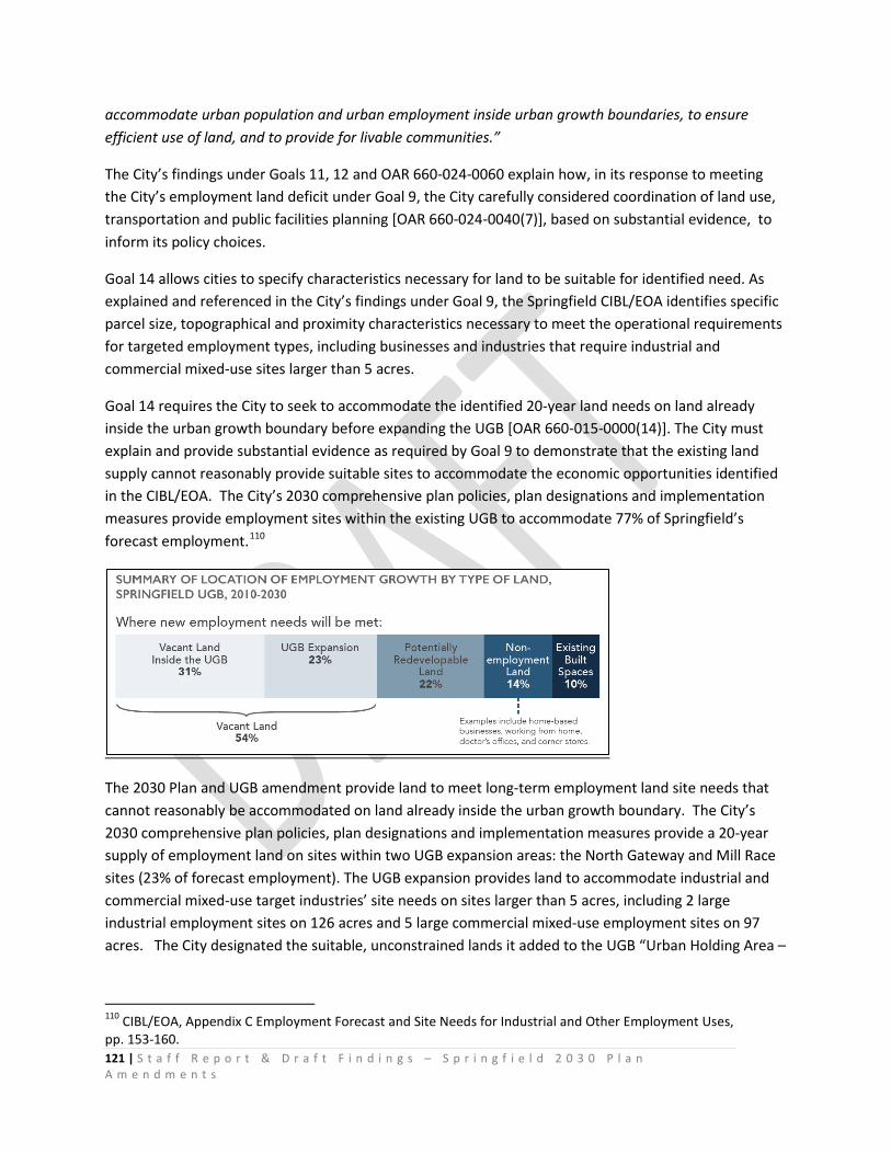
121 | S t a f f R e p o r t & D r a f t F i n d i n g s – S p r i n g f i e l d 2 0 3 0 P l a n A m e n d m e n t s
accommodate urban population and urban employment inside urban growth boundaries, to ensure efficient use of land, and to provide for livable communities.”
The City’s findings under Goals 11, 12 and OAR 660-024-0060 explain how, in its response to meeting the City’s employment land deficit under Goal 9, the City carefully considered coordination of land use, transportation and public facilities planning [OAR 660-024-0040(7)], based on substantial evidence, to inform its policy choices.
Goal 14 allows cities to specify characteristics necessary for land to be suitable for identified need. As explained and referenced in the City’s findings under Goal 9, the Springfield CIBL/EOA identifies specific parcel size, topographical and proximity characteristics necessary to meet the operational requirements for targeted employment types, including businesses and industries that require industrial and commercial mixed-use sites larger than 5 acres.
Goal 14 requires the City to seek to accommodate the identified 20-year land needs on land already inside the urban growth boundary before expanding the UGB [OAR 660-015-0000(14)]. The City must explain and provide substantial evidence as required by Goal 9 to demonstrate that the existing land supply cannot reasonably provide suitable sites to accommodate the economic opportunities identified in the CIBL/EOA. The City’s 2030 comprehensive plan policies, plan designations and implementation measures provide employment sites within the existing UGB to accommodate 77% of Springfield’s forecast employment.110
The 2030 Plan and UGB amendment provide land to meet long-term employment land site needs that cannot reasonably be accommodated on land already inside the urban growth boundary. The City’s 2030 comprehensive plan policies, plan designations and implementation measures provide a 20-year supply of employment land on sites within two UGB expansion areas: the North Gateway and Mill Race sites (23% of forecast employment). The UGB expansion provides land to accommodate industrial and commercial mixed-use target industries’ site needs on sites larger than 5 acres, including 2 large industrial employment sites on 126 acres and 5 large commercial mixed-use employment sites on 97 acres. The City designated the suitable, unconstrained lands it added to the UGB “Urban Holding Area –
110 CIBL/EOA, Appendix C Employment Forecast and Site Needs for Industrial and Other Employment Uses, pp. 153-160.
122 | S t a f f R e p o r t & D r a f t F i n d i n g s – S p r i n g f i e l d 2 0 3 0 P l a n A m e n d m e n t s
Employment (UHA-E)” to provide a 20-year supply of employment land to accommodate the need for large sites.
The 2030 Plan Economic and Urbanization Element policies identify these specific employment site needs and establish special planning requirements and zoning regulations to reserve the sites added to the UGB for the intended large site employment purposes. The proposed Metro Plan diagram plan amendment applies the Urban Holding Area - Employment (UHA-E) plan designation. The proposed Zoning Map amendment applies Agriculture—Urban Holding Area (AG) urban transition zoning to protect the large employment sites from land divisions and incompatible interim development. Together, these actions plan and zone lands added to the UGB for employment to establish minimum parcel sizes, topographical (flat topography) and proximity characteristics necessary to meet the operational requirements for targeted employment types.
The City’s CIBL/EOA provides substantial evidence to support the City’s policy choice under Goals 9 and 14 — expanding the UGB to add large sites to support economic opportunities and diversification of the economy. As stated in the CIBL/EOA pages 95-97:
• “Economic growth. Decision makers and community members that participated in the economic opportunities analysis agreed that economic growth is desirable over the planning period. The employment forecast indicates Springfield will add 13,440 new employees between 2010 and 2030 using the OAR 660-024-0040(8)(a)(ii) methodology. The economic opportunities analysis assumes that Springfield will have employment growth in a wide variety of businesses, from services and retail for residents to industrial development to medical services. The City wants to diversify its economy and attract higher wage and professional jobs.” (emphasis added)
• “Buildable lands. Springfield has 3,414 acres that are designated for industrial and other employment use. About two-thirds of the land designated for employment within Springfield’s UGB is considered developed and is not expected to redevelop over the 20 year planning period. Less than 15% of this land is buildable, unconstrained land. The majority of buildable, unconstrained employment land in Springfield has existing development on it that is expected to redevelop over the planning period. Springfield has a lack of buildable large sites, with one buildable site 20 acres and larger and 22 buildable sites in the five to 20 acre size range.” (emphasis added)
• Availability of sites 20 acres and larger is important for attracting or growing large businesses, which are often traded-sector businesses. If the City does not have these large sites, there is little chance that the City will attract these types of businesses. While it may not be clear exactly what the business opportunities may be in ten to twenty years, it is clear that these businesses will not locate in Springfield if land is not available for development.” (emphasis added)
• “For example, in the past twenty years, most of the Gateway area developed. The area has a mix of uses including the International Way campus employment district, regional mall, apartments, offices, and more recently, the PeaceHealth RiverBend Medical Center Campus. Twenty-years
123 | S t a f f R e p o r t & D r a f t F i n d i n g s – S p r i n g f i e l d 2 0 3 0 P l a n A m e n d m e n t s
ago it would have seemed highly unlikely that PeaceHealth would build their new regional facility in Springfield. If the City had not had desirable, serviceable land available, PeaceHealth would probably not have located their new facility in Springfield. Over the last 20 years, employment and commerce in the Gateway area has become a local and regional economic engine and major employment center. In 2006, the Gateway area had 33% of Springfield’s employment (more than 9,800 employees) and 33% of payroll in the city, at $325 million. By 2009, Gateway accounted for nearly 36% of the city’s employment and $368 million in payroll. In 2013, employment in the Gateway area accounted for 40% of employment in Springfield (more than 10,700 employees) and 43% of payroll in the city.”111
Capacity to Absorb Growth within the Existing UGB Prior to expanding an urban growth boundary, the City analyzed the capacity of land within the existing UGB to provide the needed sites, as required by Goals 9 and 14. As described in the City’s findings under Goal 9, and in the CIBL/EOA, the City has demonstrated that the identified need for employment sites larger than 5 acres cannot reasonably be accommodated on land already inside the urban growth boundary. Therefore, the City chose to expand the boundary to include suitable large sites. As stated in the CIBL/EOA pages 95-98, the City determined that the large site need could not reasonably be accommodated through redesignation or site assembly and provided substantial evidence to support the conclusions reached.
• “Redesignation of Smaller Sites. Springfield’s land deficit cannot be met through redesignating a surplus of small industrial- and commercial-designated sites, most of which are smaller than 2 acres. Map 2-3 shows that these sites are scattered throughout the City, generally along Main Street or in Mid-Springfield. There are few opportunities for assembly of a contiguous, unconstrained site with a configuration that makes it developable. These areas do not and are not expected to provide large sites for target employers that require large sites.” (emphasis added)
• “Even where small vacant sites are located adjacent to other small vacant sites, there are few places where a site larger than 5 acres could be assembled from small sites. There is probably no place where a 20-acre site could be assembled from small sites.” (emphasis added)
• “Site assembly. Assembly of numerous small sites into 5 to 10 acre sites is difficult at best and often not feasible. Map 2-3 shows that of industrial- and commercial-designated sites are scattered throughout the City, generally along Main Street or in Mid- Springfield, and the majority of sites are smaller than 2 acres. Land assembly is difficult and often costly. Developers attempting land assembly often have difficulty assembling a site at a cost that makes development economically viable. When assembling land, developers often find that owners of
111 Kim Thompson, Oregon Employment Department, “The Gateway Area & Growth in Springfield”, presentation to Gateway Development Committee, October 24, 2014.
124 | S t a f f R e p o r t & D r a f t F i n d i n g s – S p r i n g f i e l d 2 0 3 0 P l a n A m e n d m e n t s
key sites are not willing sellers, have unrealistic expectations of the value of their land, or cannot get agreement among multiple owners to sell the land. As a result, developers, especially developers of industrial buildings, typically choose to develop sites with one or two owners.” (emphasis added)
• Need to expand the UGB to accommodate need for large sites. Springfield’s need for large sites cannot be met within the UGB. Meeting this need for large sites for large employers requires the City to expand its UGB into areas with suitable sites. These areas will have relatively large, flat sites with little parcelization and few owners, where businesses will have access to I-5 or a State highway.” (emphasis added)
The CIBL/EOA is the City’s inventory and analysis of commercial and industrial land required under Goal 9. As explained in the CIBL/EOA, and in the City’s findings under Goal 9, the City’s employment land need analysis, prepared by ECONorthwest, used a “site needs” approach, based on ECONorthwest’s expertise, trends and substantial evidence to determine the number of sites and the required characteristics [ORS 197.712(2)(c)112 and the Goal 9 Administrative Rule.
The need to expand the UGB to address the City’s deficit of sites larger than 5 acres, including sites larger than 20 acres, was determined in the CIBL/EOA. The City’s findings under OAR 660-009-0020(1)(c), as explained in CIBL/EOA Chapter 5113 Land Capacity and Demand demonstrate that the City conducted analysis to determine how employment capacity could be provided within the existing UGB prior to expanding its urban growth boundary.
• The CIBL/EOA analysis identified lands with redevelopment potential. • The CIBL/EOA analysis identified sites smaller than 5 acres with redevelopment potential in
Table 2-11 and Table 5-1. • The CIBL/EOA analysis identified sites larger than 5 acres with redevelopment potential in Table
2-11 and Table 5-1.
112 ORS 197.712***“the Legislative Assembly finds and declares that, in carrying out statewide comprehensive land use planning, the provision of adequate opportunities for a variety of economic activities throughout the state is vital to the health, welfare and prosperity of all the people of the state. (2) By the adoption of new goals or rules, or the application, interpretation or amendment of existing goals or rules, the Land Conservation and Development Commission shall implement all of the following: (a) Comprehensive plans shall include an analysis of the communitys economic patterns, potentialities, strengths and deficiencies as they relate to state and national trends. (b) Comprehensive plans shall contain policies concerning the economic development opportunities in the community. (c) Comprehensive plans and land use regulations shall provide for at least an adequate supply of sites of suitable sizes, types, locations and service levels for industrial and commercial uses consistent with plan policies. (d) Comprehensive plans and land use regulations shall provide for compatible uses on or near sites zoned for specific industrial and commercial uses.” (emphasis added) 113 CIBL/EOA, pp. 77-82,

125 | S t a f f R e p o r t & D r a f t F i n d i n g s – S p r i n g f i e l d 2 0 3 0 P l a n A m e n d m e n t s
• CIBL/EOA Table 2-12 presents a site-by-site evaluation of redevelopment potential of sites identified as potentially redevelopable in Table 2-11. Table 5-1 includes all of the sites identified as providing an opportunity for redevelopment of a 5-acre site (in Table 2-12) as potentially redevelopable sites over the planning period.
• The CIBL/EOA determined redevelopment capacity as follows: o All sites 5 acres and smaller that were identified as having redevelopment
potential may redevelop over the 2010-2030 period. o Five sites between 5-20 acres and one site 20 acres and larger are likely to
redevelop over the 2010-2030 period. Table 2-12 provides a site-by-site evaluation of redevelopment potential for sites larger than 5 acres.
o As shown in CIBL/EOA Table 5-1, Springfield concludes that 188 industrial sites and 340 commercial and mixed use sites would redevelop to address land needs over the 20-year period. In addition to this assumption about redevelopment, Springfield concludes that all land needs on sites smaller than five acres would be accommodated through redevelopment.
• To accommodate Springfield’s forecast employment growth of 13,440 employees over the 2010-2030 planning period, the City’s CIBL/EOA assumes the following:
o 14% of new employment (1,918 employees) will locate on land not designated for employment use, such as residential land (Table C-12).
o 10% of new employment (1,344 employees) will locate in existing commercial or industrial built space, such as vacant buildings or office spaces (Table C-12).
o 22% of new employment (about 2,921 employees) will locate on potentially redevelopable sites, where redevelopment results in an increase in the amount of employment accommodated on the site (Table 5-1 shows assumptions about potentially redevelopable sites and Table C-6 shows that need for sites smaller than 5 acres will be accommodated through redevelopment).
o 54% of new employment (about 7,256 employees) will locate on land that is currently vacant, including land within the UGB and sites that Springfield does not currently have within the UGB (Table 5-1 and Table C-6).
As explained in the City’s findings under Goal 9, the City conducted the required analysis to determine how employment capacity could be provided within the existing UGB prior to expanding the UGB. The City conducted a reasonable level of analysis to determine redevelopment potential of sites within the existing UGB to add capacity. The City’s assumptions and conclusions are consistent with Goal 14 because the City’s CIBL/EOA determined how employment capacity could be provided within the existing UGB prior to expanding its urban growth boundary and the City’s policy choices were based on substantial evidence.
The CIBL/EOA provides substantial evidence to explain the City’s assumption about capacity reasonably likely to be provided by the “potentially redevelopable” sites larger than 5 acres to accommodate needed employment sites larger than 5 acres. The City conducted site-by-site evaluation of sites 5 acres and larger with redevelopment potential to determine whether it is reasonable for the City to assume

126 | S t a f f R e p o r t & D r a f t F i n d i n g s – S p r i n g f i e l d 2 0 3 0 P l a n A m e n d m e n t s
that some or all of these sites could meet the identified need for sites larger than 5 acres. As shown in CIBL/EOA (pp. 33-39), Table 2-12 and explanatory text, the City finds that is reasonable to assume that 7 of these 14 potentially redevelopable sites 5 acres and larger offer opportunities for redevelopment once site constraints, configuration issues, and existing employment uses are accounted for. These sites are:
• Six sites between 5 and 20 acres in size:
o 12-acre site in the Jasper-Natron Special Heavy Industrial District o 10-acre site on 28th Street in Heavy Industrial o 8-acre site on 42nd Street in Heavy Industrial o 7-acre site at 28th and Marcola Road in Heavy Industrial o 6.5-acre site on 28th Street in Heavy Industrial o 6-acre site on Highbanks Road in Heavy Industrial
• One site larger than 20 acres in size:
o 36-acre site in the Jasper-Natron Special Heavy Industrial District
The City assumed that all land needs for sites smaller than 5 acres could be accommodated on land already inside the urban growth boundary.
The City’s assumptions, conclusions and policy choices about accommodating 46% of forecast employment growth on land already inside the UGB are reasonable and based on substantial evidence.
The City has conducted the required analysis and has provided sufficient evidence demonstrating that all of its employment needs cannot be accommodated on land already inside the urban growth boundary, thus the City proposed to amend the UGB to provide land designated to provide suitable sites larger than 5 acres and larger than 20 acres to meet those needs.
2030 Plan Compliance with Goal 14 [OAR 660-015-0000(14)]
Urban Growth Boundary and Urbanization Policies
Urban growth boundaries shall be established and maintained by cities, counties and regional governments to provide land for urban development needs and to identify and separate urban and urbanizable land from rural land. Establishment and change of urban growth boundaries shall be a cooperative process among cities, counties and, where applicable, regional governments. An urban growth boundary and amendments to the boundary shall be adopted by all cities within the boundary and by the county or counties within which the boundary is located, consistent with intergovernmental agreements…
127 | S t a f f R e p o r t & D r a f t F i n d i n g s – S p r i n g f i e l d 2 0 3 0 P l a n A m e n d m e n t s
Amendment of Springfield’s UGB is a cooperative process between the City of Springfield and Lane County. The City Council adopted the amended UGB on _______, Ordinance X; Lane County adopted the amended UGB on _______, Ordinance X.
Goal 14 addresses how cities and counties must plan and zone land within urban growth boundaries to manage the long term land supply:
“Urbanizable Land. Land within urban growth boundaries shall be considered available for urban development consistent with plans for the provision of urban facilities and services. Comprehensive plans and implementing measures shall manage the use and division of urbanizable land to maintain its potential for planned urban development until appropriate public facilities and services are available or planned.” OAR 660-015-0000(14)
The City’s 2030 Plan Economic and Urbanization Element comprehensive policies identify specific industrial site needs and commercial mixed-use employment site needs and establish special planning requirements and zoning regulations to reserve these sites for the intended large site employment purposes.
The City amended the Metro Plan text to establish the Urban Holding Area - Employment (UHA-E) plan designation.
The City amended the Metro Plan diagram to apply the Urban Holding Area - Employment (UHA-E) plan designation to the lands added to the UGB to meet employment land needs.
The City amended the Springfield Development Code to establish the Agriculture – Urban Holding Area (AG) urban transition zoning to protect the large employment sites added to the UGB to meet employment land needs from land divisions and incompatible interim development.
The City amended the Springfield Zoning Map to apply the Agriculture – Urban Holding Area (AG) urban transition zoning to protect the large employment sites from land divisions and incompatible interim development.
The City’s amendments to the comprehensive plan designate urbanizable lands suitable for employment, and protect those sites from land divisions and incompatible interim development by applying plan designations, comprehensive plan urbanization policies and implementing zoning measures.
Implementation of the 2030 Plan amendments will manage the interim use and division of urbanizable employment land with suitable parcel size, topographical and proximity characteristics that are necessary to meet specific operational required by targeted employment types.
Implementation of the 2030 Plan amendments will function to reserve lands with specific operational required by targeted employment types, as described in the City’s EOA and substantiated with an

128 | S t a f f R e p o r t & D r a f t F i n d i n g s – S p r i n g f i e l d 2 0 3 0 P l a n A m e n d m e n t s
adequate factual base in the record, to maintain the land’s potential for planned urban development of urban employment uses and densities, as required by Goal 14.
Implementation of the 2030 Plan amendments will manage the interim use and division of urbanizable employment land to maintain the land’s potential for planned urban development of urban employment uses and densities until appropriate public facilities and services are available or planned, as required by Goal 14.
The City and Lane County adopted 2030 Urbanization Element policies to replace the more generalized regional policies in the Metro Plan. The 2030 Urbanization Element is the chapter of the 2030 Plan that guides future development in Springfield by describing how and where land will be developed and infrastructure provided to meet long term growth needs while maintaining and improving community livability. The purpose of the Urbanization Element is to inform and guide long range land use and public facilities planning to address Springfield’s land needs for the planning period 2010-2030 in compliance with Statewide Planning Goal 14, Urbanization. The Urbanization Element establishes the comprehensive plan policies and zoning applicable to urbanizable lands within Springfield’s Urban Growth Boundary (UGB) that are necessary to efficiently and effectively plan and manage the land supply as land uses transition from rural to urban. This policy direction is based on the need to:
• Designate a 20-year supply of urbanizable land to accommodate population and employment growth.
• Allow and regulate interim land uses that do not impede future development of planned urban land uses and densities.
• Plan for the orderly and efficient extension of public facilities and services. • Designate land for community open space and recreational needs. • Designate land to provide and manage the public facilities and environmental services needed
to serve Springfield’s urban area. • Manage growth and improve community livability through increasingly efficient use of land
consistent and compatible with the community’s needs, resources, opportunities and advantages within the broader Southern Willamette Valley region.
The guidelines in Goal 14 state that plans “should” designate sufficient amounts of urbanizable land to accommodate the need for further urban expansion, taking into account (1) the growth policy of the area; (2) the needs of the forecast population; (3) the carrying capacity of the planning area; and (4) open space and recreational needs.
Springfield’s 2030 Plan designates sufficient amounts of urbanizable land to accommodate the needs of the forecast population’s need for housing and employment; adds land designated Public/Semi-Public to accommodate a portion of the area’s open space and recreational needs; and adds land designated Natural Resource and Public/Semi-Public to maintain open space, conserve resources, and conserve the quantity and quality of Springfield’s drinking water supply. 2030 Urbanization Element policies require refinement-level comprehensive planning for the
129 | S t a f f R e p o r t & D r a f t F i n d i n g s – S p r i n g f i e l d 2 0 3 0 P l a n A m e n d m e n t s
lands designated Urban Holding Area – Employment to ensure that urban uses and densities can be accommodated within the carrying capacity of the planning area. The guidelines in Goal 14 state: “The size of the parcels of urbanizable land that are converted to urban land should be of adequate dimension so as to maximize the utility of the land resource and enable the logical and efficient extension of services to such parcels.”
The urbanizable land added to the UGB in Springfield’s 2030 Comprehensive Plan is primarily large parcels in single ownership because Springfield’s employment land deficit is sites larger than 5 acres, including 3 sites larger than 20 acres. Parcels are of adequate dimension so as to maximize the utility of the land resource and enable the logical and efficient extension of services to such parcels. 2030 Urbanization Element policies require retention of UHA-E designated large parcels (20-acre and 50-acre minimum parcel sizes). The AG District includes provisions to limit the division of land and prohibit urban development. A 50-acre minimum lot size is applied to lots/parcels greater than 50 acres and a 20-acre minimum lot size is applied to lots/parcels less than 50 acres to protect undeveloped sites from inefficient piecemeal development until land is planned and zoned to allow annexation and site development with urban employment uses and densities. The guidelines in Goal 14 state: “Plans providing for the transition from rural to urban land use should take into consideration as to a major determinant the carrying capacity of the air, land and water resources of the planning area. The land conservation and development actions provided for by such plans should not exceed the carrying capacity of such resources.”
The guidelines in Goal 14 state: “Comprehensive plans and implementing measures for land inside urban growth boundaries should encourage the efficient use of land and the development of livable communities.”
The 2030 Urbanization Element policies and AG zone land use regulations address the transition from rural to urban land uses and require newly urbanizable areas to be planned comprehensively to address air, land and water resources of the planning area — as required by Oregon and federal law — to ensure that urban uses and densities can provide needed capacity for employment growth and enhance overall community livability. The UGB Alternatives Analysis process addressed and compared the relative ESEE consequences of potentially suitable expansion location alternatives to assess potential threats or benefits to air, land and water resources. To determine capacity issues, the UGB Alternatives Analysis process included planning–level assessments of infrastructure (e.g. wastewater, water, stormwater management) and transportation facilities needed to serve alternate locations. The Metro Wastewater (MWMC) Treatment Facility has capacity to treat wastewater from the two proposed UGB expansion areas. The Urbanization Element provides policies and implementation strategies to implement the following goals:
UG-4 As the City grows and as land develops, maintain and reinforce Springfield’s identity as a river-oriented community emphasizing and strengthening physical
130 | S t a f f R e p o r t & D r a f t F i n d i n g s – S p r i n g f i e l d 2 0 3 0 P l a n A m e n d m e n t s
connections between people and nature in the City’s land development patterns and green infrastructure systems. UG-5 Increase Springfield’s capability to respond to natural hazard impacts and to enhance public safety, health and robustness of the economy and natural environment. Create opportunities for innovative urban development and economic diversification.
Future design and development of public infrastructure and private development in the urbanizable lands designated Urban Holding Area – Employment will require the use of “green infrastructure” systems and other low impact development practices to manage stormwater, and to maintain and improve water quality. Refinement-level comprehensive planning will identify locations and/or conceptual alignments of “green infrastructure” systems. 2030 Urbanization Element Policy 50 states:
“Grow and develop the City in ways that will to ensure the stability of Springfield’s public drinking water supply to meet current and future needs.
• Prior to City approval of annexation, land division or site development in the North Gateway and Mill Race UHA-E districts, the City — in partnership with Springfield Utility Board — shall conduct a Springfield Development Code Amendment process to prepare and apply specialized development standards that protect Drinking Water Source Areas to urbanizable lands designated UHA-E to ensure that new development contributes to a safe, clean, healthy, and plentiful community drinking water supply. The standards shall identify design, development, construction and best management processes appropriate and necessary to maintain aquifer recharge and protect drinking water quality and quantity. The standards shall also identify land use buffers appropriate and necessary to protect the Willamette Wellfield and the surface water features that are known to be in hydraulic connection with the alluvial aquifer.
• Continue to Update the Springfield Comprehensive Plan and Springfield Development Code as new natural hazards information becomes available.
• Encourage increased integration of natural systems into the built environment, such as vegetated water quality stormwater management systems and energy-efficient buildings.”
2030 Urbanization Element Policy 51 states:
“Grow and develop the City in ways that maintain and improve Springfield’s air quality to benefit public health and the environment.
• Prioritize and seek funding for mixed use land use district planning and multi-modal transportation projects that reduce reliance on single occupancy
131 | S t a f f R e p o r t & D r a f t F i n d i n g s – S p r i n g f i e l d 2 0 3 0 P l a n A m e n d m e n t s
vehicles (SOVs) consistent with Springfield Transportation System Plan (TSP) Policy 1.2, 1.3 and 1.4.
• Coordinate land use and transportation system planning for urbanizable
lands at the refinement plan and/or Master Plan level to identify and conceptually plan alignments for locating multi – modal facilities.
• Plan, zone and design transportation systems in the North Gateway and Mill
Race Urban Holding Area - Employment districts to provide multi-modal transportation choices for district employees.
• Promote the use of active transportation systems as new growth areas and significant new infrastructure are planned and developed.”
The guidelines in Goal 14 state: “The type, design, phasing and location of major public transportation facilities (i.e., all modes: air, marine, rail, mass transit, highways, bicycle and pedestrian) and improvements thereto are factors which should be utilized to support urban expansion into urbanizable areas and restrict it from rural areas.” The 2030 Plan amendments encourage and require the efficient use of land and development of livable communities within Springfield’s UGB by establishing a land base for employment that relies on existing developed land to meet 46% of employment growth; by accommodating 77% of employment growth within the existing UGB; by accommodating all employment land needs for sites smaller than 5 acres without expanding the UGB; by expanding the UGB to support economic diversification and job creation in areas that are proximate to the existing and planned public transit system; and through 2030 Plan Economic Element policies that promote higher density mixed-use development in locations served by the region’s Frequent Transit Network (FTN). The City’s 2030 Plan directs urban expansion for employment to urbanizable sites within the existing UGB and UF-10 Overlay Zoning District through the annexation process and to newly urbanizable sites in the North Gateway and Mill Race UGB expansion areas. The City’s priority location for short term urban expansion is the Glenwood Riverfront/Franklin Corridor. In 2015, the area is beginning to urbanize, but many unincorporated urbanizable sites remain and are expected to redevelop in the planning period to provide sites to meet employment land needs. The area is part of the City’s Glenwood Urban Renewal District. The City is using tax increment financing to phase public facilities and services to support redevelopment of the area. The UGB Alternatives Analysis process assessed the type, location and potential phasing of public facilities and services as important factors in reviewing the feasibility and cost of extending facilities and services to alternative locations for urban expansion. The City Engineer provided planning–level assessments of infrastructure (e.g. wastewater, water, stormwater management) and transportation
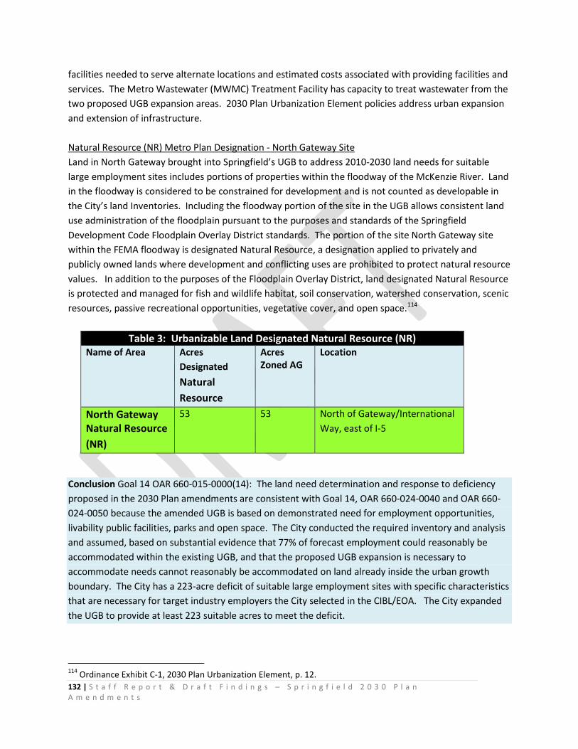
132 | S t a f f R e p o r t & D r a f t F i n d i n g s – S p r i n g f i e l d 2 0 3 0 P l a n A m e n d m e n t s
facilities needed to serve alternate locations and estimated costs associated with providing facilities and services. The Metro Wastewater (MWMC) Treatment Facility has capacity to treat wastewater from the two proposed UGB expansion areas. 2030 Plan Urbanization Element policies address urban expansion and extension of infrastructure. Natural Resource (NR) Metro Plan Designation - North Gateway Site Land in North Gateway brought into Springfield’s UGB to address 2010-2030 land needs for suitable large employment sites includes portions of properties within the floodway of the McKenzie River. Land in the floodway is considered to be constrained for development and is not counted as developable in the City’s land Inventories. Including the floodway portion of the site in the UGB allows consistent land use administration of the floodplain pursuant to the purposes and standards of the Springfield Development Code Floodplain Overlay District standards. The portion of the site North Gateway site within the FEMA floodway is designated Natural Resource, a designation applied to privately and publicly owned lands where development and conflicting uses are prohibited to protect natural resource values. In addition to the purposes of the Floodplain Overlay District, land designated Natural Resource is protected and managed for fish and wildlife habitat, soil conservation, watershed conservation, scenic resources, passive recreational opportunities, vegetative cover, and open space.114
Table 3: Urbanizable Land Designated Natural Resource (NR) Name of Area Acres
Designated Natural Resource
Acres Zoned AG
Location
North Gateway Natural Resource (NR)
53 53 North of Gateway/International Way, east of I-5
Conclusion Goal 14 OAR 660-015-0000(14): The land need determination and response to deficiency proposed in the 2030 Plan amendments are consistent with Goal 14, OAR 660-024-0040 and OAR 660-024-0050 because the amended UGB is based on demonstrated need for employment opportunities, livability public facilities, parks and open space. The City conducted the required inventory and analysis and assumed, based on substantial evidence that 77% of forecast employment could reasonably be accommodated within the existing UGB, and that the proposed UGB expansion is necessary to accommodate needs cannot reasonably be accommodated on land already inside the urban growth boundary. The City has a 223-acre deficit of suitable large employment sites with specific characteristics that are necessary for target industry employers the City selected in the CIBL/EOA. The City expanded the UGB to provide at least 223 suitable acres to meet the deficit.
114 Ordinance Exhibit C-1, 2030 Plan Urbanization Element, p. 12.
133 | S t a f f R e p o r t & D r a f t F i n d i n g s – S p r i n g f i e l d 2 0 3 0 P l a n A m e n d m e n t s
Division 24 Urban Growth Boundaries
OAR 660-024-0000 Purpose and Applicability
OAR 660-024-0000(4)
“The rules in this division adopted on December 4, 2015, are effective January 1, 2016, except that a local government may choose to not apply the amendments to rules in this division adopted December 4, 2015 to a plan amendment concerning the amendment of a UGB, regardless of the date of that amendment, if the local government initiated the amendment of the UGB prior to January 1, 2016.”
The 2030 Plan amendment of the UGB was initiated on December 31, 2009 and was prepared to address the requirements of the applicable statutes and rules in effect at that time, including ORS 197.298 and Division 24 Urban Growth Boundaries cert. ef. 4-16-09.
The City issued the public notice specified in OAR 660-018-0020 for the proposed plan amendment concerning the evaluation or amendment of the UGB on December 31, 2009, under the rules in Division 24 that were adopted prior to that date, and effective April 16, 2009.
OAR 660-024-0000(3)(c)
“A local government choice whether to apply this division must include the entire division and may not differ with respect to individual rules in the division.”
As permitted under OAR 660-024-0000(4) the City’s proposal applies Division 24 Urban Growth Boundaries cert. ef. 4-16-09.
Conclusion OAR 660-024-0000: The City’s proposal is consistent with OAR 660-024-0000. The City’s findings under Goal 14 are organized under ORS 197.298 and the Division 24 administrative rule effective prior to January 1, 2016.
OAR 660-024-0010 Goal 14 Definitions Applicable to Springfield’s UGB Analysis
OAR 660-024-0010 Definitions states:
“In this division, the definitions in the statewide goals and the following definitions apply…”
The definitions in the statewide goals and the following definitions in Division 24 are applicable to Springfield’s demonstration of compliance with Division 24:
(2) "EOA" means an economic opportunities analysis carried out under OAR 660-009-0015.
134 | S t a f f R e p o r t & D r a f t F i n d i n g s – S p r i n g f i e l d 2 0 3 0 P l a n A m e n d m e n t s
(7) "Safe harbor" means an optional course of action that a local government may use to satisfy a requirement of Goal 14. Use of a safe harbor prescribed in this division will satisfy the requirement for which it is prescribed. A safe harbor is not the only way or necessarily the preferred way to comply with a requirement and it is not intended to interpret the requirement for any purpose other than applying a safe harbor within this division.
(8) “Suitable vacant and developed land” describes land for employment opportunities, and has the same meaning as provided in OAR 660-009-0005 section (1) for “developed land,” section (12) for “suitable,” and section (14) for “vacant land.”
The definition of “suitable” as provided in OAR 660-009-0005 section (12) is a key element in Springfield’s inventory and analysis of employment land need, in the city’s finding that all employment land needs cannot be met on lands within the UGB, and the City’s decision to amend the UGB to add suitable land to meet identified employment land needs.
OAR 660-024-0020 Adoption or Amendment of a UGB
OAR 660-024-0020(1)
“All statewide goals and related administrative rules are applicable when establishing or amending a UGB, except as follows:
Pages 17-18 of these findings address the statewide goals and related administrative rules applicable when establishing or amending a UGB.
(a) The exceptions process in Goal 2 and OAR chapter 660, division 4, is not applicable unless a local government chooses to take an exception to a particular goal requirement, for example, as provided in OAR 660-004-0010(1);
(b) Goals 3 and 4 are not applicable;
(c) Goal 5 and related rules under OAR chapter 660, division 23, apply only in areas added to the UGB, except as required under OAR 660-023-0070 and 660-023-0250;
Pages 435-448 of these findings address Goal 5 as it applies only in areas added to the UGB, except as required under OAR 660-023-0070 and 660-023-0250.
(d) The transportation planning rule requirements under OAR 660-012-0060 need not be applied to a UGB amendment if the land added to the UGB is zoned as urbanizable land, either by retaining the zoning that was assigned prior to inclusion in the boundary or by assigning interim zoning that does not allow development that would generate more vehicle trips than development allowed by the zoning assigned prior to inclusion in the boundary;
135 | S t a f f R e p o r t & D r a f t F i n d i n g s – S p r i n g f i e l d 2 0 3 0 P l a n A m e n d m e n t s
Pages 481-526 of these findings address Goal 12.
(e) Goal 15 is not applicable to land added to the UGB unless the land is within the Willamette River Greenway Boundary;
The proposed UGB includes land within the Willamette River Greenway Boundary. Pages 424-428 of these findings address Goal 15.
(f) Goals 16 to 18 are not applicable to land added to the UGB unless the land is within a coastal shorelands boundary;
(g) Goal 19 is not applicable to a UGB amendment.
As stated on page 18, Goal 10 is not applicable.
Conclusion OAR 660-024-0020 (1) The City addressed all applicable statewide goals and related administrative rules when the City and Lane County amended the UGB.
OAR 660-024-0020(2)
“The UGB and amendments to the UGB must be shown on the city and county plan and zone maps at a scale sufficient to determine which particular lots or parcels are included in the UGB. Where a UGB does not follow lot or parcel lines, the map must provide sufficient information to determine the precise UGB location.”
Conclusion OAR 660-024-0020(2): Ordinance Exhibit A includes plan designation and zoning maps at a scale sufficient to determine which particular lots or parcels are included in the UGB. Exhibit C includes the amended UGB map at a scale sufficient to determine which particular lots or parcels are included in the UGB. Exhibit C-2 provides more detailed description of the amended boundary, providing sufficient information to determine the precise UGB location.
OAR 660-024-0030(1) Coordinated Population Forecast
“Counties must adopt and maintain a coordinated 20-year population forecast for the county and for each urban area within the county consistent with statutory requirements for such forecasts under ORS 195.025 and 195.036. Cities must adopt a 20-year population forecast for the urban area consistent with the coordinated county forecast, except that a metropolitan service district must adopt and maintain a 20-year population forecast for the area within its jurisdiction. In adopting the coordinated forecast, local governments must follow applicable procedures and requirements in ORS 197.610 to 197.650 and must provide notice to all other local governments in the county. The adopted forecast must be included in the comprehensive plan or in a document referenced by the plan.”
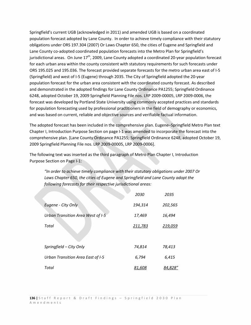
136 | S t a f f R e p o r t & D r a f t F i n d i n g s – S p r i n g f i e l d 2 0 3 0 P l a n A m e n d m e n t s
Springfield’s current UGB (acknowledged in 2011) and amended UGB is based on a coordinated population forecast adopted by Lane County. In order to achieve timely compliance with their statutory obligations under ORS 197.304 (2007) Or Laws Chapter 650, the cities of Eugene and Springfield and Lane County co-adopted coordinated population forecasts into the Metro Plan for Springfield’s jurisdictional areas. On June 17th, 2009, Lane County adopted a coordinated 20-year population forecast for each urban area within the county consistent with statutory requirements for such forecasts under ORS 195.025 and 195.036. The forecast provided separate forecasts for the metro urban area east of I-5 (Springfield) and west of I-5 (Eugene) through 2035. The City of Springfield adopted the 20-year population forecast for the urban area consistent with the coordinated county forecast. As described and demonstrated in the adopted findings for Lane County Ordinance PA1255; Springfield Ordinance 6248, adopted October 19, 2009 Springfield Planning File nos. LRP 2009-00005, LRP 2009-0006, the forecast was developed by Portland State University using commonly accepted practices and standards for population forecasting used by professional practitioners in the field of demography or economics, and was based on current, reliable and objective sources and verifiable factual information.
The adopted forecast has been included in the comprehensive plan. Eugene–Springfield Metro Plan text Chapter I, Introduction Purpose Section on page I-1 was amended to incorporate the forecast into the comprehensive plan. [Lane County Ordinance PA1255; Springfield Ordinance 6248, adopted October 19, 2009 Springfield Planning File nos. LRP 2009-00005, LRP 2009-0006].
The following text was inserted as the third paragraph of Metro Plan Chapter I, Introduction Purpose Section on Page I-1:
“In order to achieve timely compliance with their statutory obligations under 2007 Or Laws Chapter 650, the cities of Eugene and Springfield and Lane County adopt the following forecasts for their respective jurisdictional areas:
2030 2035
Eugene - City Only 194,314 202,565
Urban Transition Area West of I-5 17,469 16,494
Total 211,783 219,059
Springfield – City Only 74,814 78,413
Urban Transition Area East of I-5 6,794 6,415
Total 81,608 84,828”
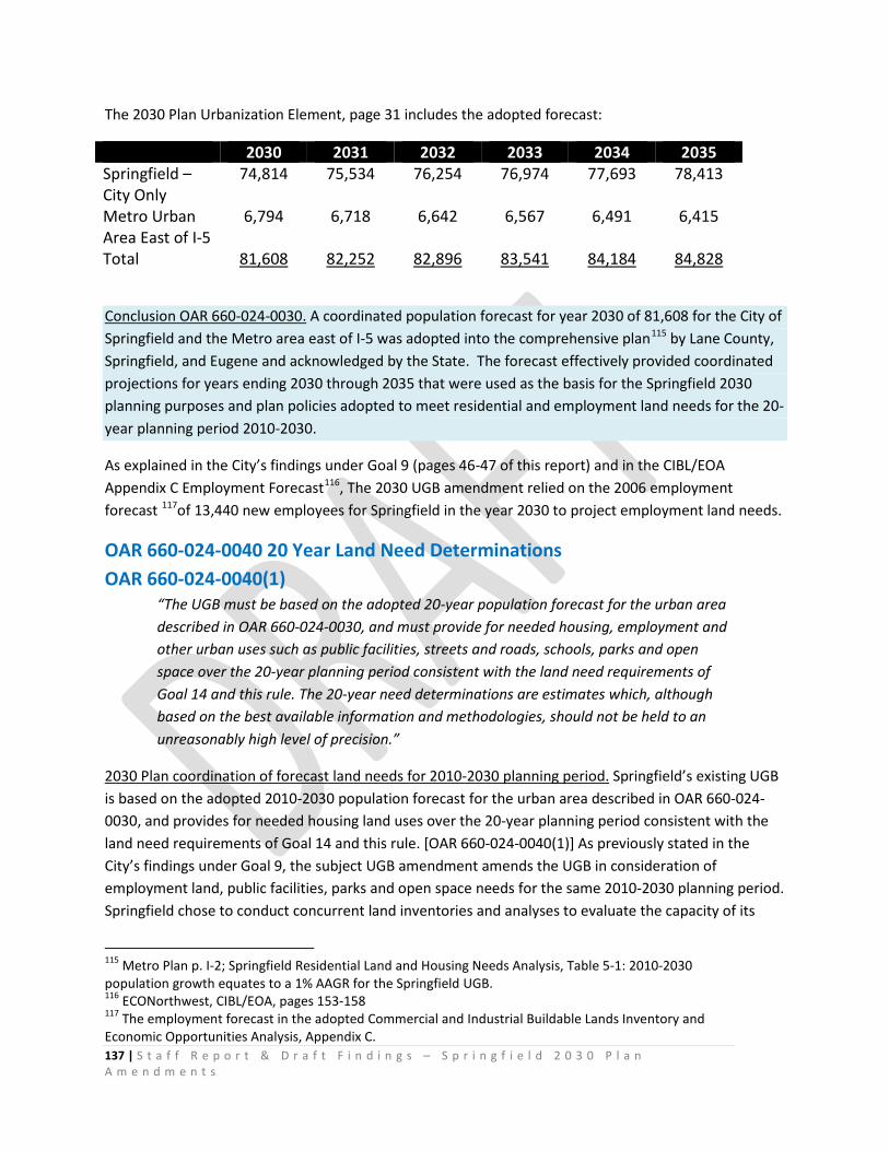
137 | S t a f f R e p o r t & D r a f t F i n d i n g s – S p r i n g f i e l d 2 0 3 0 P l a n A m e n d m e n t s
The 2030 Plan Urbanization Element, page 31 includes the adopted forecast:
2030 2031 2032 2033 2034 2035 Springfield – City Only
74,814 75,534 76,254 76,974 77,693 78,413
Metro Urban Area East of I-5
6,794 6,718 6,642 6,567 6,491 6,415
Total 81,608 82,252 82,896 83,541 84,184 84,828
Conclusion OAR 660-024-0030. A coordinated population forecast for year 2030 of 81,608 for the City of Springfield and the Metro area east of I-5 was adopted into the comprehensive plan115 by Lane County, Springfield, and Eugene and acknowledged by the State. The forecast effectively provided coordinated projections for years ending 2030 through 2035 that were used as the basis for the Springfield 2030 planning purposes and plan policies adopted to meet residential and employment land needs for the 20-year planning period 2010-2030.
As explained in the City’s findings under Goal 9 (pages 46-47 of this report) and in the CIBL/EOA Appendix C Employment Forecast116, The 2030 UGB amendment relied on the 2006 employment forecast 117of 13,440 new employees for Springfield in the year 2030 to project employment land needs.
OAR 660-024-0040 20 Year Land Need Determinations OAR 660-024-0040(1)
“The UGB must be based on the adopted 20-year population forecast for the urban area described in OAR 660-024-0030, and must provide for needed housing, employment and other urban uses such as public facilities, streets and roads, schools, parks and open space over the 20-year planning period consistent with the land need requirements of Goal 14 and this rule. The 20-year need determinations are estimates which, although based on the best available information and methodologies, should not be held to an unreasonably high level of precision.”
2030 Plan coordination of forecast land needs for 2010-2030 planning period. Springfield’s existing UGB is based on the adopted 2010-2030 population forecast for the urban area described in OAR 660-024-0030, and provides for needed housing land uses over the 20-year planning period consistent with the land need requirements of Goal 14 and this rule. [OAR 660-024-0040(1)] As previously stated in the City’s findings under Goal 9, the subject UGB amendment amends the UGB in consideration of employment land, public facilities, parks and open space needs for the same 2010-2030 planning period. Springfield chose to conduct concurrent land inventories and analyses to evaluate the capacity of its
115 Metro Plan p. I-2; Springfield Residential Land and Housing Needs Analysis, Table 5-1: 2010-2030 population growth equates to a 1% AAGR for the Springfield UGB. 116 ECONorthwest, CIBL/EOA, pages 153-158 117 The employment forecast in the adopted Commercial and Industrial Buildable Lands Inventory and Economic Opportunities Analysis, Appendix C.
138 | S t a f f R e p o r t & D r a f t F i n d i n g s – S p r i n g f i e l d 2 0 3 0 P l a n A m e n d m e n t s
UGB for housing needs and commercial/industrial land needs. Springfield began the Residential Land Study (RLS) in 2007 and the Commercial and Industrial Buildable Lands Study (CIBL) in 2008. Springfield chose to take actions in response to the simultaneous evaluations separately in order to meet the City’s obligation under ORS 197.304 to adopt a separate Springfield UGB to meet it housing needs in a timely manner.
Springfield previously reviewed its UGB in consideration of one category of land need – housing. Springfield’s acknowledged comprehensive plan (the Metro Plan) was amended to address Springfield’s land need for housing and residential purposes for the planning period 2010-2030. Springfield has demonstrated that its acknowledged Urban Growth Boundary, comprehensive plan Residential Land Use and Housing Element policies and implementation actions will provide sufficient buildable lands for residential purposes within the urban growth boundary established pursuant to statewide planning goals to accommodate estimated housing needs for the 2010-2030 planning period. [Springfield Ordinance 6268 adopted June 20, 2011, and Lane County PA1274, acknowledged July 25, 2011 (DLCD File Number 009-09)] The subject 2030 Plan amendments were closely coordinated with Springfield’s previously acknowledged comprehensive planning actions addressing Goal 10 and do not alter Springfield’s existing acknowledged comprehensive plan designations, policies or land use regulations addressing housing needs for 2010-2030.118
Springfield Ordinance 6268 and Lane County Ordinance PA1274 identified a deficit of 300 acres to meet 2010-2030 public land, parks and open space needs. The subject UGB amendment partially addresses this category of land need — as explained in the City’s findings under Goals 8 and 11 — by adding existing public parks, open space and public facilities to accommodate parks, open space and public facilities needs within the UGB and Metro Plan boundary. Inclusion of these lands (approximately 455 acres) within the Springfield UGB and Metro plan boundary enables and facilitates coordination and management of facilities /land use/transportation planning under consistent plan policies and land use regulations.
Conclusion OAR 660-024-0040(1). The 2030 Plan amendments amend the UGB to provide for employment and other uses including public facilities, streets and roads, parks and open space over the 2010-2030 planning period. The 2030 Plan UGB amendment, plan policies, plan designations and land use regulations implement Goal 14 Urbanization by providing urbanizable119 land in the Springfield UGB
118 Springfield was able to accommodate its 20-year residential growth needs without expanding the UGB. The City was able to meet its housing needs through redesignation of land in its Glenwood Nodal Development / MMS areas to meet the identified HDR deficit. The City adopted land use efficiency measures into the Springfield Development Code (Ordinance 6286) including 8 du/acre minimum density in the LDR zone, SLR small lot residential zone (3000 sq. ft. min lot size, etc.). Lands designated for residential uses are needed to meet forecast 2010-2030 residential land needs and thus cannot be redesignated to meet employment needs. Existing Mixed-use plan designations, zoning and the City’s 2030 Comprehensive Plan policies require and support mixed-use development to meet Springfield’s identified needs for multi-family housing. 119 Goal 14: “Urbanizable Land. Land within urban growth boundaries shall be considered available for urban development consistent with plans for the provision of urban facilities and services. Comprehensive
139 | S t a f f R e p o r t & D r a f t F i n d i n g s – S p r i n g f i e l d 2 0 3 0 P l a n A m e n d m e n t s
designated for urban development needs — based on a demonstrated need for employment opportunities, livability, public facilities, parks and open space for the planning period 2010-2030.
OAR 660-024-0040(2) Establishment of 2010-2030 Planning Period
“If the UGB analysis or amendment is conducted as part of a periodic review work program, the 20-year planning period must commence on the date initially scheduled for completion of the appropriate work task. If the UGB analysis or amendment is conducted as a post-acknowledgement plan amendment under ORS 197.610 to 197.625, the 20-year planning period must commence either:
(a) On the date initially scheduled for final adoption of the amendment specified by the local government in the initial notice of the amendment required by OAR 660-018-0020;”
The 2010-2030 planning period was established to commence on the 2010 date initially scheduled for final adoption of the amendment as stated in the City’s submittal [“Overview,” document, page 2, submitted to DLCD December 31, 2009].120 The 2010-2030 planning period is based on the beginning of the 20-year period specified in the coordinated population forecast for the urban area adopted by the city and county pursuant to OAR 660-024-0030 and the date initially scheduled for final adoption.
In 2010, a 20 year population forecast for the Springfield urban area was adopted into the Metro Plan [page I-2] for year 2030.
Springfield’s UGB analysis and 2030 Plan amendment is not part of periodic review work program. Springfield’s proposal is essentially a PAPA of the Eugene-Springfield Metro Plan that is “reviewed in the manner of periodic review” because it includes an amendment of the UGB. The study was initiated to meet the City’s obligation to establish a separate UGB from Eugene, in response to ORS 197.304, adopted into law in 2007:
ORS 197.304 Lane County accommodation of needed housing
(1) Notwithstanding an intergovernmental agreement pursuant to ORS 190.003 (Definitions for ORS 190.003 to 190.130) to 190.130 (Effect of ORS 190.125) or
plans and implementing measures shall manage the use and division of urbanizable land to maintain its potential for planned urban development until appropriate public facilities and services are available or planned. [OAR 660-015-0000(14)] 120 The initial notice of the amendment was submitted on December 31, 2009, more than 20 days before the date of the first evidentiary hearing date of February 17, 2010, consistent with ORS 197.610 (1). The proposed 2030 Plan Metro Plan amendments (including residential, employment and urbanization elements and a proposal to expand the UGB) were the subject of the initial evidentiary hearing — conducted by the Springfield and Lane County Planning Commissions on February 17, 2010.
140 | S t a f f R e p o r t & D r a f t F i n d i n g s – S p r i n g f i e l d 2 0 3 0 P l a n A m e n d m e n t s
acknowledged comprehensive plan provisions to the contrary, a city within Lane County that has a population of 50,000 or more within its boundaries shall meet its obligation under ORS 197.295 (Definitions for ORS 197.295 to 197.314 and 197.475 to 197.490) to 197.314 (Required siting of manufactured homes) separately from any other city within Lane County. The city shall, separately from any other city:
(a) Establish an urban growth boundary, consistent with the jurisdictional area of responsibility specified in the acknowledged comprehensive plan; and
(b) Demonstrate, as required by ORS 197.296 (Factors to establish sufficiency of buildable lands within urban growth boundary), that its comprehensive plan provides sufficient buildable lands within an urban growth boundary established pursuant to statewide planning goals to accommodate estimated housing needs for 20 years.
(2) Except as provided in subsection (1) of this section, this section does not alter or affect an intergovernmental agreement pursuant to ORS 190.003 (Definitions for ORS 190.003 to 190.130) to 190.130 (Effect of ORS 190.125) or acknowledged comprehensive plan provisions adopted by Lane County or local governments in Lane County. [2007 c.650 §2]
1 “Sec.3 A local government that is subject to section 2 of this 2007 Act [197.304] shall complete the inventory, analysis and determination required under ORS 197.296(3) to begin compliance with section 2 of this 2007 Act within two years after the effective date of this 2007 Act [January 1, 2008]” (emphasis added)
The City commenced the Springfield 2030 Plan’s planning period on year 2010 to 1) mesh seamlessly with the County’s adopted coordinated population forecast period; to meet the City’s obligation to complete the housing inventory, analysis and determination before January 1, 2010, and 3) to closely coordinate Springfield’s residential and commercial/ industrial land inventories and analyses processes that would serve as the factual bases for the Springfield UGB and respective Springfield 2030 Comprehensive Plan policy elements.
The planning period 2010-2030 complies with OAR 660-024-0040(2)(a)and(b).
Conclusion OAR 660-024-0040(2). The 2010-2030 planning period is based on the beginning of the 20-year period specified in the coordinated population forecast for the urban area adopted by the city and county pursuant to OAR 660-024-0030 and the date initially scheduled for final adoption.
OAR 660-024-0040(3) Amending the UGB to Meet Employment, Public Land, Parks and Open Space Needs
“(3) A local government may review and amend the UGB in consideration of one category of land need (for example, housing need) without a simultaneous review and

141 | S t a f f R e p o r t & D r a f t F i n d i n g s – S p r i n g f i e l d 2 0 3 0 P l a n A m e n d m e n t s
amendment in consideration of other categories of land need (for example, employment need).”
The City and Lane County request approval of Springfield’s review of the UGB in consideration of employment land need as explained in these findings and in response to the employment land need determination and factual basis contained in Ordinance Exhibit B-2: 2030 Plan Economic Element Technical Supplement CIBL/EOA Final Report 2015. The City and Lane County request approval of Springfield’s UGB amendment adding approximately 257 acres of land designated “Urban Holding Area- Employment” to accommodate the identified need of at least 223 suitable acres for employment purposes.
The City and Lane County request approval of Springfield’s review of the UGB in consideration of public facilities, parks and open space needs as explained in these findings and in response to the factual basis contained in Ordinance 6268, the Willamalane Parks and Recreation District need assessment and Comprehensive Plan (previously adopted as a refinement of the Metro Plan), the Metro Area Public Facilities and Services Plan, and Springfield Utility Board facilities plans. The City and Lane County request approval of Springfield’s UGB amendment adding approximately 455 acres of land designated “Public/Semi-public.”
Conclusion: OAR 660-024-0040(3). As previously stated in the City’s findings under Goal 9, the City is amending the UGB in consideration of employment land needs. The 2030 Plan amendments also amend the UGB to provide public facilities, streets and roads, parks and open space over the 2010-2030 planning period.
OAR 660-024-0040(5) Determination of 20-Year Employment Land Need
“Except for a metropolitan service district described in ORS 197.015(13), the determination of 20-year employment land need for an urban area must comply with applicable requirements of Goal 9 and OAR chapter 660, division 9, and must include a determination of the need for a short-term supply of land for employment uses consistent with OAR 660-009-0025. Employment land need may be based on an estimate of job growth over the planning period; local government must provide a reasonable justification for the job growth estimate but Goal 14 does not require that job growth estimates necessarily be proportional to population growth.”
Applicable requirements of Goal 9 and OAR Chapter 660, division 9 relating to determination of 20-year employment land need are focused on development and adoption of an Economic Opportunities Analysis (OAR 660-009-0015). As discussed under Goal 9 above, the City of Springfield has adopted an Economic Opportunities Analysis consistent with OAR 660-009-0015 requirements, including:
1) A trends analysis (CIBL/EOA Chapter 3, Economic Trends and Factors Affecting Future Economic Growth in Springfield);
142 | S t a f f R e p o r t & D r a f t F i n d i n g s – S p r i n g f i e l d 2 0 3 0 P l a n A m e n d m e n t s
2) Identification of long term and short term employment site needs (CIBL/EOA Chapter 4, Land Demand and Site Needs in Springfield, and Chapter 2, pp. 40-41 Analysis of Short Term Supply of Land);
3) Suitable lands inventory (EOA Chapter 2, Land Available for Industrial and Other Employment Uses); and
4) An assessment of community economic development potential (CIBL/EOA Chapters 3 & 4).
As explained in detail in Appendix C to the CIBL/EOA (Employment Forecast and Site Needs for Industrial and other Employment Needs), employment land need identified in the EOA is based on forecast employment growth over the planning period (13,440 new jobs through 2030).121 Springfield’s population is forecast to reach 81,608 by 2030.122
The results of the CIBL/EOA (Table 5-4 Employment site and land needs, Springfield UGB 2010-2030) indicate that Springfield’s proposed current UGB does not provide sufficient land to meet Springfield’s employment needs and economic development objectives, therefore Springfield must 1. adopt amendments to the comprehensive plan to address deficiencies; and 2. expand the UGB to provide suitable, serviceable land that can be designated to provide the appropriate site characteristics to meet the needs of target industries. Springfield has a land need for seven sites larger than 5 acres, including 3 sites larger than 20 acres (2 industrial sites 20 acres and larger; 1 commercial and mixed-use site 20 acres; and 4 commercial and mixed-use sites 5-20 acres in size).
Conclusions: OAR 660-024-0040(5). As demonstrated in the City’s findings under Goal 9, Springfield’s 20-year employment land need has been established in accordance with the applicable requirements of Goal 9 and OAR chapter 660, division 9, including a determination of the need for a short-term supply of land for employment uses consistent with 660-009-0025. The 2030 UGB uses the 2006 employment forecast of 13,440 new employees for Springfield in the year 2030 to project employment land needs, consistent with OAR 660-024-0040(5). The CIBL/EOA provides a reasonable justification for the job growth estimate, based on substantial evidence.
After accounting for available land supply and the results of efficiency measures, Table 5-4 of the CIBL/EOA identifies employment needs that require expansion of the UGB as follows: Commercial and Mixed-Use (Land Need = 5 sites, 97 acres). After accounting for vacant, partially-vacant and potentially redevelopable commercial and mixed use land supply within the UGB, there is an unmet need for 5 commercial and mixed-use sites totaling an estimated 97 acres.
Industrial (Land Need = 2 sites, 126 acres). After accounting for vacant, partially-vacant and potentially redevelopable industrial land supply within the UGB, unmet industrial need is identified as 2 large sites, totaling an estimated 126 acres.
The total employment land needed in the UGB expansion to meet site needs is 223 suitable acres:
121 CIBL/EOA Appendix C, p. 153-156. 122 Table 5-1, Springfield Residential Land and Housing Needs Analysis. 2010-2030 population growth equates to a 1% AAGR for the Springfield UGB.
143 | S t a f f R e p o r t & D r a f t F i n d i n g s – S p r i n g f i e l d 2 0 3 0 P l a n A m e n d m e n t s
3 sites larger than 20 acres and 4 sites 5-20 acres.
OAR 660-024-0040(7) Determination of 20-year land needs for transportation and public facilities
“The determination of 20-year land needs for transportation and public facilities for an urban area must comply with applicable requirements of Goals 11 and 12, rules in OAR chapter 660, divisions 11 and 12, and public facilities requirements in ORS 197.712 and 197.768. The determination of school facility needs must also comply with ORS 195.110 and 197.296 for local governments specified in those statutes.”
The City’s findings under Goals 11, 12 and OAR 660-024-0060 explain how 20-year land needs for transportation and public facilities were addressed in the 2030 Plan amendments to demonstrate continued compliance with applicable requirements of Goals 11 and 12, rules in OAR chapter 660, divisions 11 and 12, and public facilities requirements in ORS 197.712 and 197.768. The 2030 Plan amendments also amend the UGB and Metro Plan Boundary to include existing publicly-owned lands that accommodate public water system well fields and water treatment facilities and Willamalane Park and Recreation District parks and open space facilities, based on previously acknowledged need determinations.123 These public uses are location-specific and cannot be accommodated on other land already inside the urban growth boundary.
Determination of lands needed for public facilities, parks and open space is established in the Metro Public Facilities and Services Plan, Springfield water, wastewater and stormwater facilities plans, and the Willamalane Park and Recreation District Comprehensive Plan. An unmet 300-acre deficit of public/semi-public land to meet park and recreation needs was previously identified in the Springfield RLHNA.
School facility needs were previously addressed in the acknowledged Residential Land and Housing Needs Analysis and existing UGB and are not addressed in the subject 2030 Plan amendments.124
Conclusions: OAR 660-024-0040(7). The City provided substantial evidence to explain how the 2030 Plan amendments coordinate land use, transportation and public facilities planning to address applicable requirements of Goals 11 and 12, rules in OAR chapter 660, divisions 11 and 12, and public facilities requirements in ORS 197.712 and 197.768.
The City’s findings under Goals 8 and 11 provide reasonable justification for the City and Lane County’s policy choice to include approximately 455 acres of existing public parks, open space and water system public facilities in the amended Springfield UGB and Metro Plan boundary, based on previously
123 Willamalane Parks and Recreation Comprehensive Plan and Eugene-Springfield Metropolitan Area Public facilities and Services Plan 124 Springfield Public Schools Administrative Facilities Plan, January 1, 2010 “provides up-to-date data related to school district facilities, sites and enrollment and provides information to update our 2006 Facilities Plan. This report addresses the items laid out in ORS 195.110 requiring school facilities plans for large school districts.”
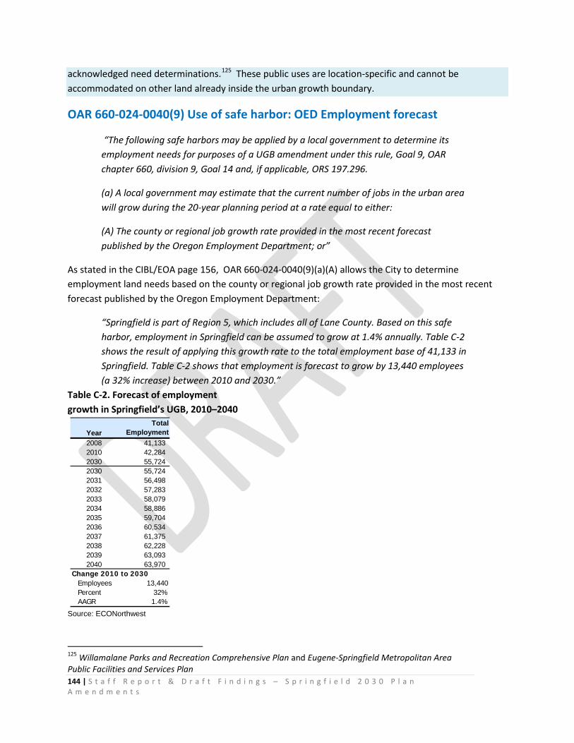
144 | S t a f f R e p o r t & D r a f t F i n d i n g s – S p r i n g f i e l d 2 0 3 0 P l a n A m e n d m e n t s
acknowledged need determinations.125 These public uses are location-specific and cannot be accommodated on other land already inside the urban growth boundary.
OAR 660-024-0040(9) Use of safe harbor: OED Employment forecast
“The following safe harbors may be applied by a local government to determine its employment needs for purposes of a UGB amendment under this rule, Goal 9, OAR chapter 660, division 9, Goal 14 and, if applicable, ORS 197.296.
(a) A local government may estimate that the current number of jobs in the urban area will grow during the 20-year planning period at a rate equal to either:
(A) The county or regional job growth rate provided in the most recent forecast published by the Oregon Employment Department; or”
As stated in the CIBL/EOA page 156, OAR 660-024-0040(9)(a)(A) allows the City to determine employment land needs based on the county or regional job growth rate provided in the most recent forecast published by the Oregon Employment Department:
“Springfield is part of Region 5, which includes all of Lane County. Based on this safe harbor, employment in Springfield can be assumed to grow at 1.4% annually. Table C-2 shows the result of applying this growth rate to the total employment base of 41,133 in Springfield. Table C-2 shows that employment is forecast to grow by 13,440 employees (a 32% increase) between 2010 and 2030.”
Table C-2. Forecast of employment growth in Springfield’s UGB, 2010–2040
Source: ECONorthwest
125 Willamalane Parks and Recreation Comprehensive Plan and Eugene-Springfield Metropolitan Area Public Facilities and Services Plan
YearTotal
Employment2008 41,133 2010 42,284 2030 55,724 2030 55,724 2031 56,498 2032 57,283 2033 58,079 2034 58,886 2035 59,704 2036 60,534 2037 61,375 2038 62,228 2039 63,093 2040 63,970
Change 2010 to 2030Employees 13,440Percent 32%AAGR 1.4%
145 | S t a f f R e p o r t & D r a f t F i n d i n g s – S p r i n g f i e l d 2 0 3 0 P l a n A m e n d m e n t s
Conclusion: OAR 660-024-0040(9). The CIBL/EOA employment land need determination for the 2010-2030 planning period was based on the best available information and accepted methodologies, including an employment forecast based on the county or regional job growth rate provided by the Oregon Employment Department, as allowed under OAR 660-024-0040(9)(a)(A).
Conclusion: OAR 660-024-0040. The CIBL/EOA employment land need determination was conducted concurrently with Springfield’s (previously acknowledged) Residential Land Use and Housing Needs Analysis need determination for the same 2010-2030 planning period. Thus, the employment forecast and land need determination were coordinated126 in response to the new split of the Metro Plan UGB between Springfield and Eugene; and to Springfield’s policy decision to increase opportunities for employment to residents in the city over time while supporting Regional Economic Prosperity plan goals.
Throughout the multi-year public process, questions and assertions have been raised suggesting that the City’s CIBL/EOA relies on “stale” information because the City has not updated the employment forecast or inventory data used in the analysis (since July 2008), and thus has not utilized the most current available information as the factual basis for the conclusions reached. Similar contentions of error were made by opponents of the Scappoose UGB decision. As stated in the Court of Appeals legal opinion for that case, such assertions were dismissed by LCDC: “the choice between conflicting evidence is the city’s. The appellants have not established and the commission does not find that a reasonable person could not have relied on the employment data the city used.”127 In the Scappoose decision, the commission concluded that newer information submitted would not “require the city to undertake multiple, shifting iterations of the same analysis as it moves through the planning and adoption process.”
The City respectfully considered all information presented throughout the multi-year planning process (2008-2016) and reasoned that none of the challenges to the Springfield inventory, analysis methodologies used, or conclusions reached would make it unreasonable for the City to rely on the employment and inventory data in the record that formed the basis of its CIBL/EOA. The City asserts that the inventory and analysis contained in the CIBL/EOA appropriately represents a “snapshot in time;” was coordinated with the County’s population forecast for the 20-year period commencing on the date commencing on the date initially scheduled for final adoption of the amendment specified by the local government in the initial notice of the amendment required by OAR 660-018-0020; was prepared in full compliance with Oregon law and the applicable administrative rule; and utilized the county or regional job growth rate provided in the most recent forecast published by the Oregon Employment Department at the time the CIBL/EOA was prepared, as specifically allowed under the safe harbor provided under OAR 660-024-0040(9)(a)(A). The data base used to prepare the CIBL/EOA is the
126 Metro Plan p. I-2. A year 2030 population forecast of 81,608 for the City of Springfield and the Metro area east of I-5 was adopted into the comprehensive plan by Springfield, Eugene and Lane County “in order to achieve timely compliance with the statutory obligations under ORS 197.304” and acknowledged by the State as the coordinated population basis for Springfield’s 2030 Comprehensive Plan. [OAR 660-024-0030(1)] 127 Zimmerman v. LCDC and City of Scappoose, LCDC 13UGB0001829; A153856, p. 524-525 (2014)

146 | S t a f f R e p o r t & D r a f t F i n d i n g s – S p r i n g f i e l d 2 0 3 0 P l a n A m e n d m e n t s
best available information at the time of CIBL/EOA preparation (2008-2009) — the pre-hearing formulation of the economic opportunities analysis developed in conjunction with the community visioning process and citizen involvement activities as fully documented in the local record. The employment land assumptions made and conclusions reached in the CIBL/EOA and the city’s policy choices in response to that land inventory and analysis were reasonable and are supported by substantial evidence in the whole record.
OAR 660-024-0050(1) Land Inventory and Response to Deficiency
“When evaluating or amending a UGB, a local government must inventory land inside the UGB to determine whether there is adequate development capacity to accommodate 20-year needs determined in OAR 660-024-0040…For employment land, the inventory must include suitable vacant and developed land designated for industrial or other employment use, and must be conducted in accordance with OAR 660-009-0015.”
Conclusion OAR 660-024-0050(1): The City’s findings under Goal 9, OAR 660-009-0015(3) Inventory of Industrial and Other Employment Lands (pages 53-59 of this report); OAR 660-009-0025(1) Identification of Needed Sites (pages 96-101) and under Goal 14 (pages 117-125 of this report) explain how Springfield inventoried land inside the UGB — including potentially redevelopable sites — in accordance with OAR 660-009-0015 to determine that there is not adequate development capacity to accommodate 20-year employment land needs determined in OAR 660-024-0040.
OAR 660-024-0050(3) Inventory of vacant land
“As safe harbors when inventorying land to accommodate industrial and other employment needs, a local government may assume that a lot or parcel is vacant if it is:
(a) Equal to or larger than one-half acre, if the lot or parcel does not contain a permanent building; or
(b) Equal to or larger than five acres, if less than one-half acre of the lot or parcel is occupied by a permanent building.”
The City did not choose to use the safe harbor. The City’s findings under Goal 9, OAR 660-009-0005, (pp. 30-31), and OAR 660-009-0015(3)(a)(B) (p. 57) explain how the CIBL/EOA defined vacant land. “Vacant” is defined in Chapter 2 of the CIBL/EOA as follows:
“Tax lots that have no structures or have buildings with very little value. For the purposes of this inventory, lands with improvement values under $10,000 (2008 Lane County Assessment and Taxation Data) are considered vacant (not including lands that are identified as having mobile homes).” This definition of “vacant” is more inclusive that what OAR 600-009-0005(14) requires, with the result that Springfield’s inventory includes more available land in the inventory than it would if the OAR600-009-0005(14) definition is used.”
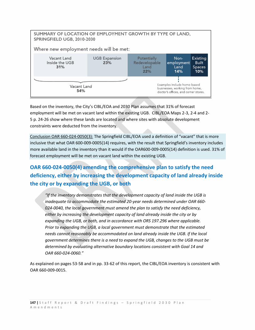
147 | S t a f f R e p o r t & D r a f t F i n d i n g s – S p r i n g f i e l d 2 0 3 0 P l a n A m e n d m e n t s
Based on the inventory, the City’s CIBL/EOA and 2030 Plan assumes that 31% of forecast employment will be met on vacant land within the existing UGB. CIBL/EOA Maps 2-3, 2-4 and 2-5 p. 24-26 show where these lands are located and where sites with absolute development constraints were deducted from the inventory.
Conclusion OAR 660-024-0050(3): The Springfield CIBL/EOA used a definition of “vacant” that is more inclusive that what OAR 600-009-0005(14) requires, with the result that Springfield’s inventory includes more available land in the inventory than it would if the OAR600-009-0005(14) definition is used. 31% of forecast employment will be met on vacant land within the existing UGB.
OAR 660-024-0050(4) amending the comprehensive plan to satisfy the need deficiency, either by increasing the development capacity of land already inside the city or by expanding the UGB, or both
“If the inventory demonstrates that the development capacity of land inside the UGB is inadequate to accommodate the estimated 20-year needs determined under OAR 660-024-0040, the local government must amend the plan to satisfy the need deficiency, either by increasing the development capacity of land already inside the city or by expanding the UGB, or both, and in accordance with ORS 197.296 where applicable. Prior to expanding the UGB, a local government must demonstrate that the estimated needs cannot reasonably be accommodated on land already inside the UGB. If the local government determines there is a need to expand the UGB, changes to the UGB must be determined by evaluating alternative boundary locations consistent with Goal 14 and OAR 660-024-0060.”
As explained on pages 53-58 and in pp. 33-62 of this report, the CIBL/EOA inventory is consistent with OAR 660-009-0015.
148 | S t a f f R e p o r t & D r a f t F i n d i n g s – S p r i n g f i e l d 2 0 3 0 P l a n A m e n d m e n t s
OAR 660-024-0050(4) is addressed on pages 119-125 of this report. The City’s findings under Goal 9128 provide explanation of policies, implementation measures, plan designations and zoning adopted by the City and Lane County to address identified land needs.
Buildable lands. Springfield has 3,414 acres that are designated for industrial and other employment use. About two-thirds of the land designated for employment within Springfield’s UGB is considered developed and is not expected to redevelop over the 20 year planning period. Less than 15% of this land is buildable, unconstrained land. The majority of buildable, unconstrained employment land in Springfield has existing development on it that is expected to redevelop over the planning period. Springfield has a lack of buildable large sites, with one buildable site 20 acres and larger and 22 buildable sites in the five to 20 acre size range.129
Redevelopment potential. The analysis of potentially redevelopable land and need for employment land assumes that Springfield will have substantial redevelopment over the planning period. The analysis of potentially redevelopable land assumes that the employment capacity of redeveloped areas will increase, not simply that a new building will replace an old building. Consistent with City Council policies, the areas that are expected to have the most redevelopment are in Glenwood, especially along the Willamette Riverfront and Franklin/McVay corridor, and in the Downtown Urban Renewal District.130
The Glenwood and Downtown redevelopment areas that are expected to have the most redevelopment are currently designated and zoned to require Mixed-use Nodal Development. The Glenwood Riverfront and Franklin/McVay corridor has been designated as a Mixed-use Multi-modal Area (MMA) pursuant to the Goal 12 administrative rule. Employment in these areas is currently served or is planned to be served by the region’s Frequent Transit Network. The City’s allocation of employment growth to land designated and zoned to require Mixed-use Nodal Development contributes to the region’s commitments to implement Transportation Planning Rule Alternative Performance Measures to reduce reliance on automobiles and Vehicle Miles Travelled (VMT).
The CIBL/EOA pages 33-38 provides a site-by-site evaluation of “Potentially Redevelopable” sites within the existing UGB that are larger than 5 acre131s. That analysis assumed that 1 needed site larger than 20 acres and 6 needed sites 5-20 acres in size could be accommodated without expanding of the UGB.
Springfield’s CIBL/EOA assumes the City will be able to meet all employment land needs on sites five acres and smaller within the existing UGB, through redevelopment, infill development, and employment uses on non-employment land (e.g., home occupations).
128 See City’s findings under OAR 660-009-0020(1)(a), (b), (c), OAR 660-009-0025(3), OAR 660-009-0020(2), OAR 660-009-0020(3), OAR 660-009-0020(4), OAR 660-009-0020(5), OAR 660-009-0020(6), OAR 660-009-0025(8), OAR 660-009-0020(7), OAR 660-009-0025, OAR 660-009-0025(1), OAR 660-009-0025(3), OAR 660-009-0025(6) pages 63-116 of this report. 129 CIBL/EOA, p. 95-96 130 Ibid 131 Explained on page 68 -69 of this report
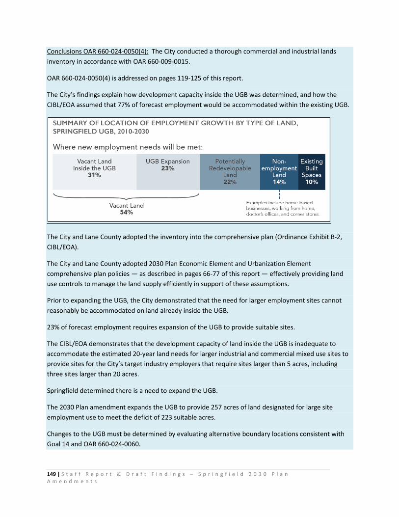
149 | S t a f f R e p o r t & D r a f t F i n d i n g s – S p r i n g f i e l d 2 0 3 0 P l a n A m e n d m e n t s
Conclusions OAR 660-024-0050(4): The City conducted a thorough commercial and industrial lands inventory in accordance with OAR 660-009-0015.
OAR 660-024-0050(4) is addressed on pages 119-125 of this report.
The City’s findings explain how development capacity inside the UGB was determined, and how the CIBL/EOA assumed that 77% of forecast employment would be accommodated within the existing UGB.
The City and Lane County adopted the inventory into the comprehensive plan (Ordinance Exhibit B-2, CIBL/EOA).
The City and Lane County adopted 2030 Plan Economic Element and Urbanization Element comprehensive plan policies — as described in pages 66-77 of this report — effectively providing land use controls to manage the land supply efficiently in support of these assumptions.
Prior to expanding the UGB, the City demonstrated that the need for larger employment sites cannot reasonably be accommodated on land already inside the UGB.
23% of forecast employment requires expansion of the UGB to provide suitable sites.
The CIBL/EOA demonstrates that the development capacity of land inside the UGB is inadequate to accommodate the estimated 20-year land needs for larger industrial and commercial mixed use sites to provide sites for the City’s target industry employers that require sites larger than 5 acres, including three sites larger than 20 acres.
Springfield determined there is a need to expand the UGB.
The 2030 Plan amendment expands the UGB to provide 257 acres of land designated for large site employment use to meet the deficit of 223 suitable acres.
Changes to the UGB must be determined by evaluating alternative boundary locations consistent with Goal 14 and OAR 660-024-0060.
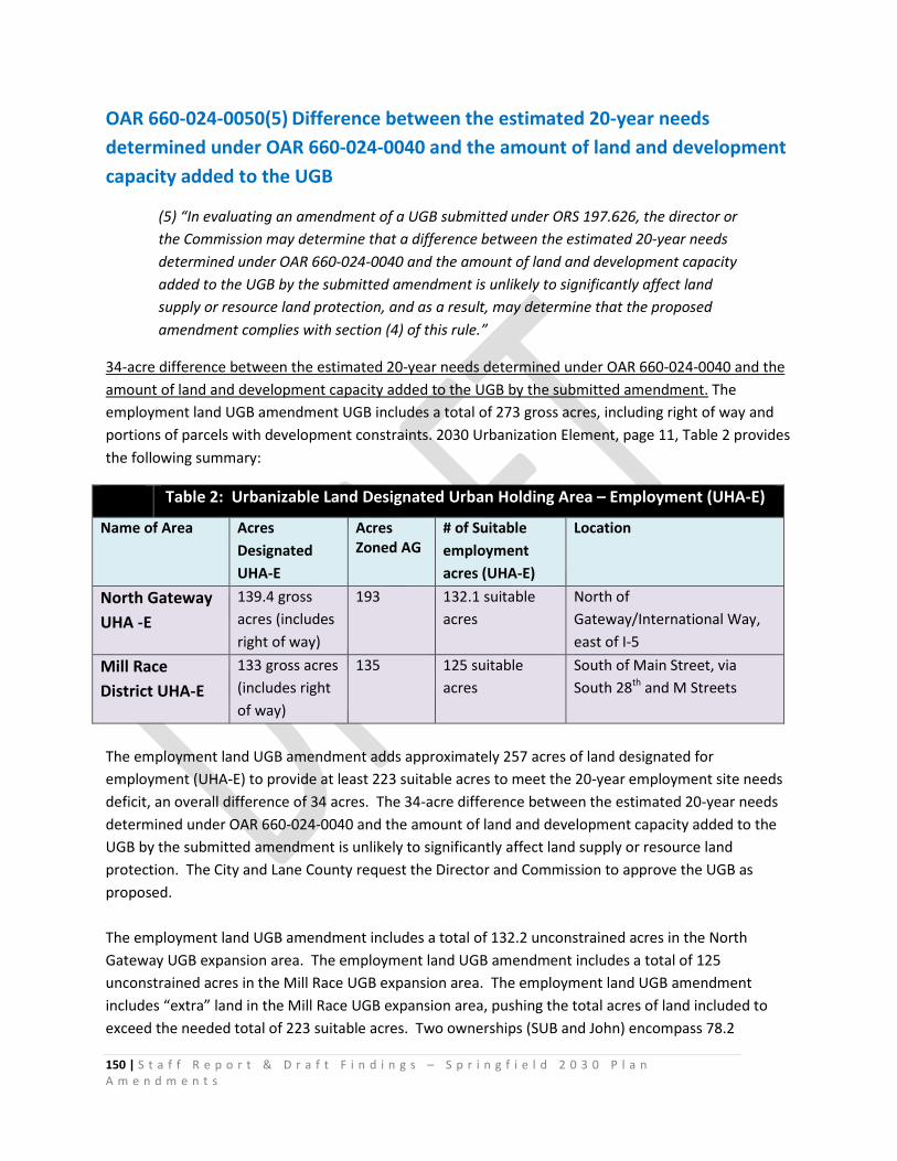
150 | S t a f f R e p o r t & D r a f t F i n d i n g s – S p r i n g f i e l d 2 0 3 0 P l a n A m e n d m e n t s
OAR 660-024-0050(5) Difference between the estimated 20-year needs determined under OAR 660-024-0040 and the amount of land and development capacity added to the UGB
(5) “In evaluating an amendment of a UGB submitted under ORS 197.626, the director or the Commission may determine that a difference between the estimated 20-year needs determined under OAR 660-024-0040 and the amount of land and development capacity added to the UGB by the submitted amendment is unlikely to significantly affect land supply or resource land protection, and as a result, may determine that the proposed amendment complies with section (4) of this rule.”
34-acre difference between the estimated 20-year needs determined under OAR 660-024-0040 and the amount of land and development capacity added to the UGB by the submitted amendment. The employment land UGB amendment UGB includes a total of 273 gross acres, including right of way and portions of parcels with development constraints. 2030 Urbanization Element, page 11, Table 2 provides the following summary:
Table 2: Urbanizable Land Designated Urban Holding Area – Employment (UHA-E)
Name of Area Acres Designated UHA-E
Acres Zoned AG
# of Suitable employment acres (UHA-E)
Location
North Gateway UHA -E
139.4 gross acres (includes right of way)
193 132.1 suitable acres
North of Gateway/International Way, east of I-5
Mill Race District UHA-E
133 gross acres (includes right of way)
135 125 suitable acres
South of Main Street, via South 28th and M Streets
The employment land UGB amendment adds approximately 257 acres of land designated for employment (UHA-E) to provide at least 223 suitable acres to meet the 20-year employment site needs deficit, an overall difference of 34 acres. The 34-acre difference between the estimated 20-year needs determined under OAR 660-024-0040 and the amount of land and development capacity added to the UGB by the submitted amendment is unlikely to significantly affect land supply or resource land protection. The City and Lane County request the Director and Commission to approve the UGB as proposed. The employment land UGB amendment includes a total of 132.2 unconstrained acres in the North Gateway UGB expansion area. The employment land UGB amendment includes a total of 125 unconstrained acres in the Mill Race UGB expansion area. The employment land UGB amendment includes “extra” land in the Mill Race UGB expansion area, pushing the total acres of land included to exceed the needed total of 223 suitable acres. Two ownerships (SUB and John) encompass 78.2
151 | S t a f f R e p o r t & D r a f t F i n d i n g s – S p r i n g f i e l d 2 0 3 0 P l a n A m e n d m e n t s
unconstrained acres in the Mill Race UGB expansion area. The City assumes that the 12.7 balance of the 223 acre land need would be met on a combination of the smaller parcels located south of the three large parcels, as shown in the map on the following page. One ownership (Reynolds) comprises 19.2 unconstrained acres. The Bales and Booth ownerships comprise at least 5 unconstrained acres. The City reasoned that including all of the parcels in the Mill Race UGB expansion area is reasonable, fair and justified as follows:
As shown in the map on the following page132, 10 of the 14 smaller parcels are located along existing South 28th, South M, and South 26th streets and right of way that currently provide access to the area and that would likely provide future access and services to the suitable large parcels owned by Johnson and Springfield Utility Board. Thus, including the smaller parcels in the UGB would support efficient and adequate provision of services to the 57-acre and 21-acre sites as the area is planned and developed for urban employment uses.
As shown in the map on the following page, leaving any of the smaller parcels (indicated with a white star) outside of the UGB would result in inefficient “island” of County-administered land use planning; would leave a potentially awkward and confusing “donut hole in the donut” of the Metro Plan Boundary and a somewhat odd configuration of the Lane Rural Comprehensive Plan boundary. In earlier work sessions, County Commissioners and City Councilors requested staff to seek UGB solutions that do not leave County-administered lands between the river the expanded UGB and Metro Plan boundary where possible. The full Mill Race map is included at Ordinance Exhibit A. As shown in the map on the following page, the Mill Race UGB expansion area includes four waterways. These features are identified and discussed in the City’s findings under Goal 5. “Riparian resources areas” are identified in the City’s CIBL/EOA as an absolute development constraint. Riparian area buffers, as required in the Springfield Development Code, were deducted from the calculation of “unconstrained acres.” If the City is required to increase buffer requirements in response to pending future federal or state legislation, the “extra” acres included in the Mill Race UGB expansion may be needed to accommodate a portion of the 223-acre overall employment land need should the City’s calculation of “unconstrained” acres in the Mill Race area be adversely affected. Thus, the Director and Commission’s approval of the UGB as proposed will enable balancing of employment needs with resource protection needs consistent with Goal 14, as allowed under OAR 660-024-0050(5) and consistent with the City’s 2030 Urbanization Element Goal UG-3:
“Provide an adequate level of urban services, including but not limited to public water, wastewater, and stormwater management systems, environmental services and an urban multi-modal transportation system as urban development occurs within the Springfield UGB.”
and 2030 Urbanization Element Goal UG-4:
132 Ordinance Exhibit A Map: “Proposed UGB Expansion Area – Mill Race”

152 | S t a f f R e p o r t & D r a f t F i n d i n g s – S p r i n g f i e l d 2 0 3 0 P l a n A m e n d m e n t s
“As the City grows and as land develops, maintain and reinforce Springfield’s identity as a river-oriented community by emphasizing and strengthening physical connections between people and nature in the City’s land development patterns and infrastructure design.”
Suitable large parcels Mill Race UGB Expansion Area
Smaller parcels included in the UGB expansion
153 | S t a f f R e p o r t & D r a f t F i n d i n g s – S p r i n g f i e l d 2 0 3 0 P l a n A m e n d m e n t s
Conclusion OAR 660-024-0050(5). The City explained its rationale for including 34 “extra” acres of suitable land in excess of the 223-acre 20-year land it added to the UGB and requests approval of its choice.
OAR 660-024-0050(6)
“When land is added to the UGB, the local government must assign appropriate urban plan designations to the added land, consistent with the need determination. The local government must also apply appropriate zoning to the added land consistent with the plan designation or may maintain the land as urbanizable land until the land is rezoned for the planned urban uses, either by retaining the zoning that was assigned prior to inclusion in the boundary or by applying other interim zoning that maintains the land's potential for planned urban development. The requirements of ORS 197.296 regarding planning and zoning also apply when local governments specified in that statute add land to the UGB.”
Ordinance Exhibit A-2 Maps illustrate the appropriate urban plan designations Springfield and Lane County assigned to lands added to the UGB:
• Proposed Plan Designations – North Gateway shows lands designated Urban holding Area- Employment, Natural Resource and Public/Semi-Public.
• Proposed Plan Designations – Mill Race shows lands designated Urban holding Area- Employment and Public/Semi-Public.
• Proposed Plan Designations – Willamalane Properties shows lands designated Public/Semi-Public.
Ordinance Exhibit A-3 Maps illustrate the appropriate zoning Springfield and Lane County assigned to lands added to the UGB: the interim Agriculture-Urban Holding Area (AG) zoning that maintains the land's potential for planned urban development, and the Public Land and Open Space (PLO) zone.
• Proposed zoning - North Gateway shows lands zoned Agriculture-Urban Holding Area (AG) and lands zoned Public Land and Open Space (PLO).
• Proposed zoning - Mill Race shows lands zoned Agriculture-Urban Holding Area (AG) and lands zoned Public Land and Open Space (PLO).
• Proposed zoning - Willamalane Properties shows lands zoned Public Land and Open Space (PLO).
OAR 660-024-0050(6) is addressed in the City’s findings on pages 106-118 of this report.
Conclusion OAR 660-024-0050(6). The City and Lane County assigned appropriate urban plan designations to the added land, to meet specific land needs and siting characteristics identified in the employment land need determination and to designate and zone land accommodating existing public facilities, parks and open space with appropriate Metro Plan/Springfield 2030
154 | S t a f f R e p o r t & D r a f t F i n d i n g s – S p r i n g f i e l d 2 0 3 0 P l a n A m e n d m e n t s
Plan designations and Springfield zoning. The AG zone is an interim zoning that maintains the land's potential for planned urban development, maintaining the suitable employment as urbanizable land until the land is rezoned for the planned urban uses as described in the policies of the 2030 Plan Urbanization Element and AG Zoning District standards.
Conclusion OAR 660-024-0050. As explained in the City’s findings and the CIBL/EOA, the City conducted inventories of 20-year land needs in accordance with the applicable statutes and rules and responded to the identified deficiencies as required under Goals 9 and 14.