Embed Size (px)
Citation preview
-1-
STAFF REPORT
59 A 35 04/29/20 W26978 S 19 R. Collins
GENERAL LEASE – PUBLIC AGENCY USE APPLICANT:
Vandenberg Village Community Services District PROPOSED LEASE:
AREA, LAND TYPE, AND LOCATION: 0.55 +/- acres of sovereign land in Burton Mesa Ecological Reserve, near Lompoc, Santa Barbara County.
AUTHORIZED USE:
Use and maintenance of an existing unpaved access road. LEASE TERM:
10 years, beginning April 29, 2020.
CONSIDERATION: $140 per year, with an annual Consumer Price Index adjustment.
SPECIFIC LEASE PROVISIONS:
• Liability insurance in an amount no less than $1,000,000 per occurrence.
• Use of the unpaved access road is restricted to Lessee’s backhoe, 10-wheel dump truck, and utility task vehicle (UTV).
• Lessee is required to obtain prior authorization for any maintenance work from the California Department of Fish and Wildlife (CDFW), including but not limited to tree trimming, grading, filling of potholes, and applying pesticides or herbicides.
• Lessee must submit a Pesticide Use Recommendation Form to CDFW and receive approval before using any pesticides or herbicides.
STAFF ANALYSIS AND RECOMMENDATION:
Authority: Public Resources Code sections 6005, 6216, 6301, 6501.1, and 6503; California Code of Regulations, title 2, sections 2000 and 2003.

STAFF REPORT NO. 59 (CONT’D)
-2-
Public Trust and State’s Best Interests Analysis: The Burton Mesa Ecological Reserve (Reserve) consists of 5,300 acres located north of Lompoc in Santa Barbara County and is held as sovereign land under the jurisdiction of the Commission. The Reserve supports one of the last significant natural stands of Burton Mesa Chaparral on the central coast. The land in the Reserve was acquired by the State in a series of transactions: 5,125 acres from Union Oil Company of California (UNOCAL) in 1991; 60 acres from UNOCAL in 1995; 47 acres from Santa Barbara County in 1998; and 68 acres from the California Department of Parks and Recreation in 2008. On December 3, 1999, the Commission authorized Lease No. PRC 8129.9 for a 49-year term to the California Department of Fish and Wildlife (CDFW) for management, operation, and maintenance of the Reserve (Item 22, December 3, 1999). Vandenberg Village Community Services District (District) was established in 1983 for the purpose of providing water and wastewater services to the community of Vandenberg Village. Vandenberg Village consists of 2,700 dwelling units with a population of 7,200 residents. The District currently maintains 32 miles of underground water pipelines and 29 miles of underground wastewater pipelines. UNOCAL granted an easement to the District’s predecessor for a 2-acre well site in 1965. Well Site 1 is used by the District for its groundwater wells, a water treatment plant, pumping equipment, maintenance shop, and storage of heavy equipment including a backhoe, 10-wheel dump truck, and portable generators. The District has a paved access road from State Route 1, but the road entrance is at the bottom of a sharp, steep, blind curve where the posted speed limit is 65 miles per hour. Ingress and egress on State Route 1 to and from the paved access road occurs within a very short 0.6-mile-long acceleration lane and left-turn pocket. The dangerous situation is exacerbated when the District’s water and sewer pipelines require maintenance work utilizing the backhoe, 10-wheel dump truck, and UTV because these are slow-moving vehicles and have extreme difficulty entering and exiting the highway from either direction without endangering public safety and disrupting normal highway traffic flow. The ability to use the existing unpaved access road from Well Site 1 north to Burton Mesa Boulevard would alleviate this dangerous situation. The District has applied for a lease to use and maintain an existing unpaved access road. The access road runs parallel to Davis Creek. Use of the access road would be restricted to use by only the backhoe, 10-wheel dump truck, and UTV. The access road has been in existence for
STAFF REPORT NO. 59 (CONT’D)
-3-
more than 50 years and is found on aerial photographs dating back to 1967. Figure 19 of the Final Land Management Plan for the Reserve designates this road as an existing Management Road. At the request of the District, the California Highway Patrol (CHP) conducted a site visit to assess existing conditions and evaluate public safety concerns. CHP supports alleviating the inherent traffic safety hazard by allowing the District to use the unpaved access road and removing a hazard to motorists on the State roadways. The District has also requested to maintain the access road in its present condition by filling ruts and potholes with gravel, grading the roadway surface, and clearing brush from both sides of the road. In its capacity as the Reserve manager, CDFW was consulted during processing of the District’s application. To alleviate concerns raised by CDFW, the lease includes Special Provisions restricting the width of the maintained area to 14 feet (2 feet on either side of the 10-foot-wide roadway), limiting certain road maintenance methods to certain times of the year, requiring tree-trimming activities to conform to Santa Barbara County Tree Preservation Ordinance, and requiring that Lessee submit CDFW Form 679, PESTICIDE USE RECOMMENDATION FORM to CDFW for review and approval. CDFW supports the Special Provisions in the lease. The proposed lease does not alienate the State’s fee simple interest, nor does it significantly impair public rights. The lease requires the District to indemnify the State for any liability incurred as a result of the District’s activities thereon. The lease requires the payment of annual rent to compensate the people of the State for the occupation of the sovereign land involved. The lease is limited to a 10-year term and does not grant the lessee exclusive rights to the leased premises.
Climate Change: The subject property is an existing unpaved road within the Reserve, which is adjacent to Davis Creek’s riparian corridor. Also adjacent to the property are oak woodland, coastal scrub, and chaparral communities. The vegetation setting of the subject property and surrounding land is vulnerable to weather events and the threat of wildland fires as noted below. The combination of more frequent and longer duration weather patterns contributing to high and unpredictable winds, low humidity, and extreme heat for California’s vegetated wildlands has contributed to an increasingly aggressive wildland fire season as a related product of climate change.
STAFF REPORT NO. 59 (CONT’D)
-4-
This threat can be further elevated through prolonged drought conditions and a lack of forest fuels reduction management for forest land areas. Climate change will further influence riverine areas by changing erosion and sedimentation rates, and flooding and storm flow, as well as runoff, will likely increase scour, decreasing bank stability at a faster rate. As stated in Safeguarding California Plan: 2018 Update (California Natural Resources Agency 2018), climate change is projected to increase the frequency and severity of natural disasters related to flooding, fire, drought, extreme heat, and storms. Pursuant to the proposed lease, the Applicant acknowledges that the lease premises are in an area that may be subject to effects of climate change. The proposed lease requires the lessee to ensure that the lease premises are maintained in a manner that does not contribute to wildland fire hazards.
Conclusion: In conclusion and based on the information above, staff believes that the proposed lease will not substantially interfere with the Public Trust needs and values at this location, at this time and for the foreseeable term of the lease; and is in the best interests of the State.
OTHER PERTINENT INFORMATION: 1. Approval or denial of the application is a discretionary action by the
Commission. Each time the Commission approves or rejects a use of sovereign land, it exercises legislatively delegated authority and responsibility as trustee of the State’s Public Trust lands as authorized by law. Upon expiration or prior termination of the lease, the lessee also has no right to a new lease or to renewal of any previous lease.
2. This action is consistent with Strategy 1.1 of the Commission’s Strategic
Plan to deliver the highest levels of public health and safety in the protection, preservation, and responsible economic use of the lands and resources under the Commission’s jurisdiction.
3. On June 21, 2019, the District determined that the project, as described
above, was categorically exempt from the California Environmental Quality Act (CEQA) pursuant to California Code of Regulations, title 14, section 15301, under Class 1, Existing Facilities. Staff concurs with the District’s determination and recommends that the Commission also find that this activity is exempt under the exemption listed above.
Authority: Public Resources Code section 21084 and California Code of
STAFF REPORT NO. 59 (CONT’D)
-5-
Regulations, title 14, section 15300.
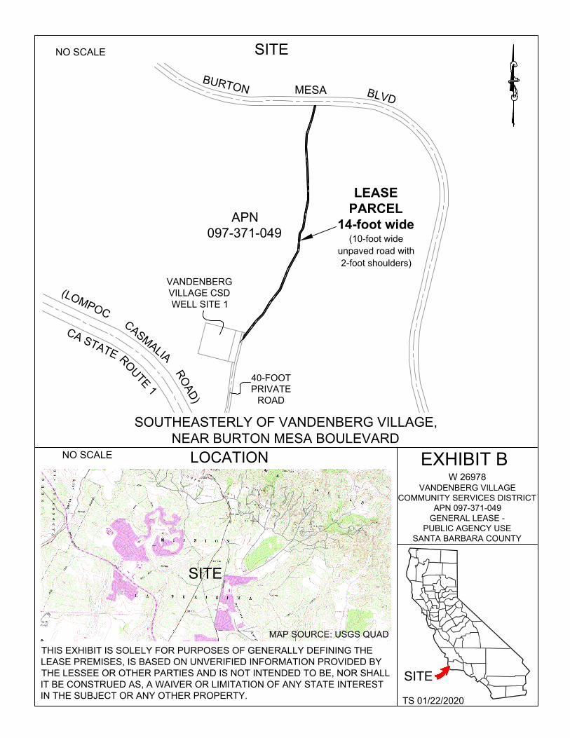
EXHIBITS: A. Land Description B. Site and Location Map
RECOMMENDED ACTION: It is recommended that the Commission:
CEQA FINDING: Find that the activity is exempt from the requirements of CEQA pursuant to California Code of Regulations, title 14, section 15061 as a categorically exempt project, Class 1, Existing Facilities; California Code of Regulations, title 14, section 15301.
PUBLIC TRUST AND STATE’S BEST INTERESTS: Find that the proposed lease will not substantially interfere with the Public Trust needs and values at this location, at this time, and for the foreseeable term of the lease; and is in the best interests of the State.
AUTHORIZATION:
Authorize issuance of a General Lease – Public Agency Use to the Applicant beginning April 29, 2020, for a term of 10 years, for use and maintenance of an unpaved access road, as described in Exhibit A and as shown on Exhibit B (for reference purposes only) attached and by this reference made a part hereof; rent in the amount of $140 per year, with an annual Consumer Price Index adjustment; and liability insurance in an amount no less than $1,000,000 per occurrence.
EXHIBIT A W26978
LAND DESCRIPTION
A 14-foot wide strip of state owned land, being a portion of Lot 12 of Rancho Mission De La Purisima, as said Lot 12 is shown on that Map filed in Book 21, Page 154 of Records of Surveys in the office of the County Recorder of County of Santa Barbara, State of California, lying seven (7) feet on the each side of the following described centerline:
COMMENCING at the southeast corner of that certain Water Well Site as shown on Record of Survey map filed in Book 60, Page 14 of Record of Surveys, in the office of the County Recorder of said County; thence South 76° 00' 25" East
60.00 feet to the center line of the 40-foot wide existing private road easement; thence along said center line North 13° 59' 35" East 200.16 feet to the POINT OF
BEGINNING; thence leaving said line along the centerline of an existing unpaved access road the following sixteen (16) courses:
1. North 37° 35' 43" East 256.09 feet;
2. North 45° 46' 14" East 87 .50 feet; 3. North 30° 19' 26" East 136.06 feet; 4. North 38° 51' 54" East 150.82 feet;
5. North 21 ° 18' 54" East 218.57 feet; 6. North 29° 06' 14" East 190.19 feet;
7. North 05° 57' 45" East 161.28 feet;
8. North 30° 14' 31" East 65.63 feet; 9. North 07° 09' 33" East 132.05 feet; 10. North 12° 28' 22" East 132.25 feet;
11.North 00° 00' 00" East 102.91 feet;
12.North 02° 39' 58" West 205.18 feet; 13. North 03° 46' 00" West 199.30 feet;
14.North 03° 26' 53" East 119.07 feet; 15. North 17° 49' 02" East 172.06 feet;
16. North 14° 34' 25" East 118.15 feet to the southerly line of Burton Mesa
Boulevard, also being the TERMINUS of said centerline.
Page 1 of 2
The sidelines of said strip to be extended or shortened so as to begin at the easterly line of 40-feet wide existing private road easement as shown on said Record of Survey and terminate at the southerly right-of-way line of Burton Mesa Boulevard.
BASIS OF BEARINGS for this description is based on Record of Survey map filed in Book 60, Page 14 of Record of Surveys.
END OF DESCRIPTION
Prepared 01/22/2020 by the California State Lands Commission Boundary Unit
Page 2 of 2
{
L : \, '''''\
··:... ..
B
U
R
T
O
N
MESA
B
L
V
D
(
L
O
M
P
O
C
C
A
S
T
A
T
E
C
A
S
M
A
L
I
A
R
O
U
T
E
1
R
O
A
D
)
NO SCALE SITE
APN 097-371-049
VANDENBERG VILLAGE CSD WELL SITE 1
LEASE PARCEL
14-foot wide (10-foot wide
unpaved road with 2-foot shoulders)
40-FOOT PRIVATE
ROAD
SOUTHEASTERLY OF VANDENBERG VILLAGE, NEAR BURTON MESA BOULEVARD
NO SCALE LOCATION
EXHIBIT B W 26978
VANDENBERG VILLAGE COMMUNITY SERVICES DISTRICT
APN 097-371-049 GENERAL LEASE -
PUBLIC AGENCY USE SANTA BARBARA COUNTY
MAP SOURCE: USGS QUAD
THIS EXHIBIT IS SOLELY FOR PURPOSES OF GENERALLY DEFINING THE LEASE PREMISES, IS BASED ON UNVERIFIED INFORMATION PROVIDED BY THE LESSEE OR OTHER PARTIES AND IS NOT INTENDED TO BE, NOR SHALL IT BE CONSTRUED AS, A WAIVER OR LIMITATION OF ANY STATE INTEREST IN THE SUBJECT OR ANY OTHER PROPERTY.
TS 01/22/2020
SITE
SITE


![TUC STAFF SWUM M] Q^ THE NET OF PRAYER …netofprayer.org/.../2011/11/THE-EARTHS-MANTLE-IS-CRACKED.pdfTUC STAFF akl[dl 1FHR[ SWUM]1D M]«Jl 1IiQ^ THE NET OF PRAYER LOVE, FAITH, HOPE](https://img.pdfslide.us/doc/110x75/5f33ef521728ba43f11e71d4/tuc-staff-swum-m-q-the-net-of-prayer-tuc-staff-akldl-1fhr-swum1d-mjl-1iiq.jpg)