Embed Size (px)
Citation preview
Stability Assessment of Chamshir Dam Based on DEM, South West
Zagros
R. Khavari
Department of Geology, Behbahan Branch, Islamic Azad University, Behbahan, Iran
Abstract. The Zagros fold-thrust belt in SW Iran is a part of the Alpine-Himalayan system consists of a
variety of structures with different sizes or geometries. The satellite images were used for structural analysis
of the Chamshir dam in southwest Iran. As well, using DEM and geological maps, 3D Models, all acquired
fracture traces data were integrated in Geographic Information System (GIS). Based on field investigation
and DEM model, main structures in the area consist of Chamshir syncline and two fault sets, the main thrust
faults with NW-SE direction and small normal faults in NE-SW direction. There are three joint sets in the
study area, both of them (J1 and J3) are the main large fractures (normal fault). In general, according to
topography, geomorphology and structural geology evidences, Chamshir dam has a potential for sliding in
some parts of Gachsaran formation.
Keywords: DEM, Chamshir Dam, Satellite Images.
1. Introduction
The assessment of the structural stability of gravity dams is an important part of the overall process on
ensuring the safety of both new and existing structures such as faults, fracture zones and folding [1].
Geological factors play a major role in designing and constructing a dam [2], as they control the nature of
geological formations and also provide the needed materials for construction. Many cases have occurred
throughout the world where dam foundation rock mass conditions were not sufficiently known and the cost
of construction and treatment greatly exceeded the original budget.
The Zagros fold-thrust belt in SW Iran is a part of the Alpine-Himalayan system which consists of a
variety of structures with different sizes or geometries. In this paper we try to evaluate stability of Chamshir
Dam based on DEM and field investigations.
2. Study Area
The Chamshir dam site on the Zuhreh River is located in south-western Iran, about 20 km southeast of
the Gachsaran city. The Zohreh River is one of the most important rivers in south of Iran. Its length is 490
km and its height from the source is 2850 m. After flowing through the township of Behbahan, it joins the
Persian Gulf. The geological formations in the study area, from oldest to youngest, are Gachsaran, Mishan,
Aghajari, Bakhtiari and alluvial sediments. The Mishan formation along with the Gachsaran formation cover
the western part of the dam reservoir and dam site [3], [4]. The Zuhreh River has created the long and narrow
Chamshir gorge by erosion of biohermy limestone, thereby making it a suitable location for dam
construction. The main lithology of the area consists of limestone and marl rocks of Mishan formation (Fig.
1). The study area is in the Zagros folded area or external Zagros [5] and simply folded belt. Zagros folding
compressional tectonic forces have created some faults and thrust faults having a NW-SE trend in the study
Corresponding author. Fax: +986152870109
E-mail address: [email protected].
2015 2nd International Conference on Geological and Civil Engineering IPCBEE vol. 80 (2015) © (2015) IACSIT Press, Singapore
DOI: 10.7763/IPCBEE. 2015. V80. 13
62

area; the Dezh solayman thrust, Murd thrust and Chamshir fault area are the most important ones.
Seismologically, it’s located in the Zagros zone and has a similar behavior [4].
Fig. 1. Location and geological setting of the study area.
Fig. 2. Classified Digital Elevation Model of the study area.
3. Materials and Methods
The satellite images are valuable means available to geologists for locating geological or
geomorphological features expressing regional fault or fracture systems, therefore, the satellite images were
used for structural analysis of the Chamshir dam area. Furthermore, in order to 3D analysis of geological
structures in the area, a detailed Digital Elevation Model (DEM) has been constructed, using digital
topographical maps. As well, using the DEM and geological maps, 3D Models of the area have been
constructed (Fig. 2). Then, based on these models, all the acquired fracture traces data were integrated in
Geographic Information System (GIS) environment by using Arc GIS software. Using the hydrologic
modeling functions in ArcGIS, it is possible to obtain the direction of surface water flow, slope value and
aspect from the filled DEM. A Digital Elevation Model is used to determine which cells flow into other cells
(the flow direction). However, if there are errors in the digital elevation model, using hydrologic analysis
63
functions, it is possible to identify them and fill. The flow direction can obtain from this depressionless
elevation model. In this study we have used 10 m grid cell DEM of Chamshir Dam. Its projection was the
UTM zone 39 N. The DEM was derived from the contour lines of the 1:25,000 topographic maps with 10 m
contour intervals.
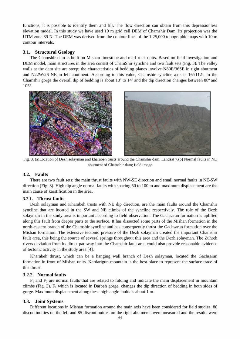
3.1. Structural Geology The Chamshir dam is built on Mishan limestone and marl rock units. Based on field investigation and
DEM model, main structures in the area consist of ChamShir syncline and two fault sets (Fig. 3). The valley
walls at the dam site are steep; the characteristics of bedding planes involve N80E/36SE in right abutment
and N22W/26 NE in left abutment. According to this value, Chamshir syncline axis is 16º/112º. In the
Chamshir gorge the overall dip of bedding is about 10º to 14º and the dip direction changes between 88º and
105º.
Fig. 3. (a)Location of Dezh solayman and kharabeh trusts around the Chamshir dam; Landsat 7.(b) Normal faults in NE
abutment of Chamshir dam; field image
3.2. Faults There are two fault sets; the main thrust faults with NW-SE direction and small normal faults in NE-SW
direction (Fig. 3). High dip angle normal faults with spacing 50 to 100 m and maximum displacement are the
main cause of karstification in the area.
3.2.1. Thrust faults
Dezh solayman and Kharabeh trusts with NE dip direction, are the main faults around the Chamshir
syncline that are located in the SW and NE climbs of the syncline respectively. The role of the Dezh
solayman in the study area is important according to field observation. The Gachsaran formation is uplifted
along this fault from deeper parts to the surface. It has dissected some parts of the Mishan formation in the
north-eastern branch of the Chamshir syncline and has consequently thrust the Gachsaran formation over the
Mishan formation. The extensive tectonic pressure of the Dezh solayman created the important Chamshir
fault area, this being the source of several springs throughout this area and the Dezh solayman. The Zuhreh
rivers deviation from its direct pathway into the Chamshir fault area could also provide reasonable evidence
of tectonic activity in the study area [4].
Kharabeh thrust, which can be a hanging wall branch of Dezh solayman, located the Gachsaran
formation in front of Mishan units. Kardarigun mountain is the best place to represent the surface trace of
this thrust.
3.2.2. Normal faults
F1 and F2 are normal faults that are related to folding and indicate the main displacement in mountain
climbs (Fig. 3). F2 which is located in Darbeh gorge, changes the dip direction of bedding in both sides of
gorge. Maximum displacement along these high angle faults is about 1 m.
3.3. Joint Systems
Different locations in Mishan formation around the main axis have been considered for field studies. 80
discontinuities on the left and 85 discontinuities on the right abutments were measured and the results were 64
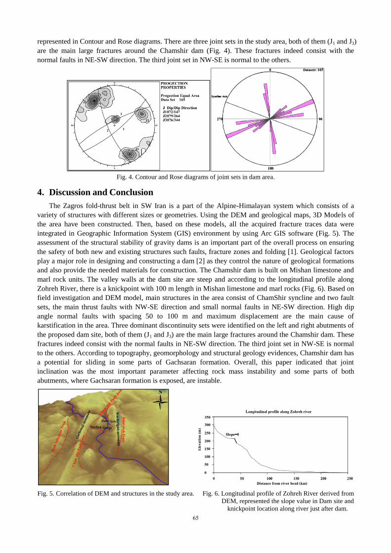
represented in Contour and Rose diagrams. There are three joint sets in the study area, both of them (J1 and J3)
are the main large fractures around the Chamshir dam (Fig. 4). These fractures indeed consist with the
normal faults in NE-SW direction. The third joint set in NW-SE is normal to the others.
Fig. 4. Contour and Rose diagrams of joint sets in dam area.
4. Discussion and Conclusion
The Zagros fold-thrust belt in SW Iran is a part of the Alpine-Himalayan system which consists of a
variety of structures with different sizes or geometries. Using the DEM and geological maps, 3D Models of
the area have been constructed. Then, based on these models, all the acquired fracture traces data were
integrated in Geographic Information System (GIS) environment by using Arc GIS software (Fig. 5). The
assessment of the structural stability of gravity dams is an important part of the overall process on ensuring
the safety of both new and existing structures such faults, fracture zones and folding [1]. Geological factors
play a major role in designing and constructing a dam [2] as they control the nature of geological formations
and also provide the needed materials for construction. The Chamshir dam is built on Mishan limestone and
marl rock units. The valley walls at the dam site are steep and according to the longitudinal profile along
Zohreh River, there is a knickpoint with 100 m length in Mishan limestone and marl rocks (Fig. 6). Based on
field investigation and DEM model, main structures in the area consist of ChamShir syncline and two fault
sets, the main thrust faults with NW-SE direction and small normal faults in NE-SW direction. High dip
angle normal faults with spacing 50 to 100 m and maximum displacement are the main cause of
karstification in the area. Three dominant discontinuity sets were identified on the left and right abutments of
the proposed dam site, both of them (J1 and J3) are the main large fractures around the Chamshir dam. These
fractures indeed consist with the normal faults in NE-SW direction. The third joint set in NW-SE is normal
to the others. According to topography, geomorphology and structural geology evidences, Chamshir dam has
a potential for sliding in some parts of Gachsaran formation. Overall, this paper indicated that joint
inclination was the most important parameter affecting rock mass instability and some parts of both
abutments, where Gachsaran formation is exposed, are instable.
Fig. 5. Correlation of DEM and structures in the study area. Fig. 6. Longitudinal profile of Zohreh River derived from
DEM, represented the slope value in Dam site and
knickpoint location along river just after dam.
65

5. Acknowledgements
This work was supported by the Behbahan branch of Islamic Azad University. We would like to thank
this department.
6. References
[1] A, Tatone BSA, Lisjak Mahabadi OK and Grasselli G (2010). "Evaluation of the combined finite-discrete element
method for the assessment of gravity dam stability". In Proceedings of the Canadian Dam Association Conference.
Niagara Falls, ON, Canada. 2-7 October, 2010
[2] K, Ichikawa., Geological investigation of dams. Proc. of 2nd
Asian Symposium on Engineering Geology and the
Environment. Malaysian National Group, Bangi, Malaysia1999, 1-44–1-57. Liu Y. R., Chang Q., Yang Q.,
WANG C. Q., GUAN F. H., Fracture analysis of rock mass based on 3-D nonlinear Finite Element Method. Sci
China Tech Sci, 54 (2011) 556–564.
[3] M, Torabi-Kaveh., Heidari, M., Zarei, H. R. and Ghiasi, M. B. Engineering geological investigation of the
foundation of the Chamshir dam site by use of DMR classification (Iran), 7th
International symposium on eastern
Mediterranean geology, University of Çukurova, Adana, Turkey, (2010). 18-22 October.
[4] M, Torabi-Kaveh., Heidari, M. An engineering geological appraisal of the Chamshir dam foundation using DMR
classification and kinematic analysis, southwest of Iran. Earth Sciences Research Journal; Dec2011, Vol. 15 Issue
2, p129
[5] J, Stocklin., Structural history and tectonics of Iran: a review: American Association of Petroleum Geologists
Bulletin, 1968a, v. 52, p. 1229–1258.
66


![gecnet.kku.ac.th · of Agriculture and Cooperation DEM [MOAC DEM]) SRTM DEM 5 SRTM DEM 5 Suriya Polpoon ... Earth's land surface is freely available for download from internet. Taking](https://img.pdfslide.us/doc/110x75/5f088e027e708231d4229689/of-agriculture-and-cooperation-dem-moac-dem-srtm-dem-5-srtm-dem-5-suriya-polpoon.jpg)