Embed Size (px)
Citation preview
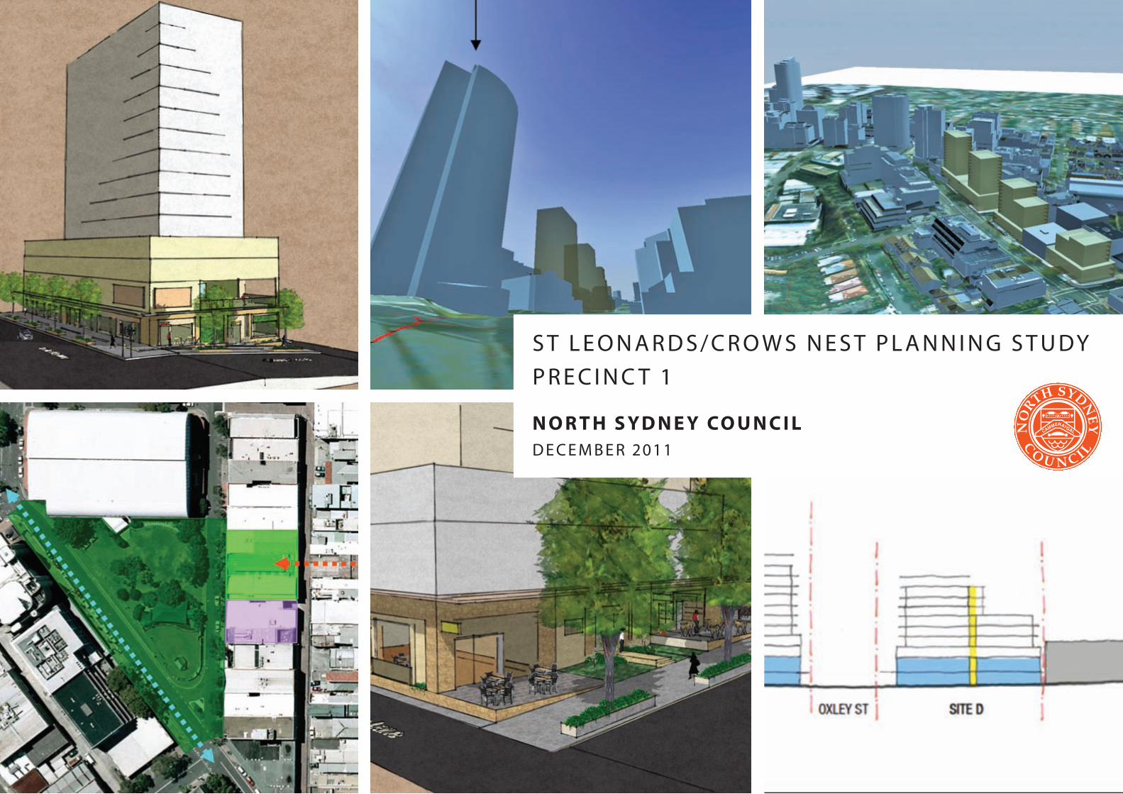
S t L e o n a r d S / c r o w S n e S t p L a n n i n g S t u dy
p r e c i n c t 1
n o r t h s y d n e y co u n c i ld e c e m b e r 2011
north Sydney council | St Leonards / crows nest planning Study – precinct 1 | december 2011 | 2
North Sydney Council is undertaking a planning study of the St Leonards / Crows Nest area. The planning study aims to develop new strategies and initiatives that will provide for the following:
• NewopenspaceinStLeonards/CrowsNest.
• IncreasedinvestmentinStLeonardsanddecreasedcommercialvacancy rates, with particular focus on the rejuvenation of the Pacific Highway between St Leonards train station and the intersection of Pacific Highway and Willoughby Road.
• Improvedconnectivity,particularlybetweenStLeonards/PacificHighway and Willoughby Road.
• ImprovedurbandesignandstreetlevelamenityparticularlyinStLeonards and along the Pacific Highway.
• ImprovedbuildingdesignandresidentialamenityinStLeonards.
This document gives a general analysis of the study area and its context and provides a more focused analysis and specific recommendations relating to a smaller planning study precinct (Precinct 1) which stretches along the eastern side of the Pacific Highway between Albany Street and Hume Street and extends eastward towards Willoughby Road.
A study area analysis, strategy review and consideration of opportunities and constraints are used to establish principles and priorities of the study relevant to Precinct 1. Those principles and priorities are then used to inform the development of options for open space, pedestrian circulation and amenity, and built form. Built form options are accompanied by feasibility studies. A preferred option, that meets the study objectives, is then presented with recommendations regarding its implementation.
The preferred option for Precinct 1 includes the following main features:
• AnexpandedHumeStreetPark;
• NewgroundlevelsetbacksonthePacificHighwayredevelopmentstrip;and
• Theintroductionofhighamenitytowersabovepodiumelementson the Pacific Highway redevelopment strip
An expanded Hume Street Park is consistent with Council’s Open Space Provision Strategy and would extend the potential functions of the park so as to better cater for the needs of new populations coming into the St Leonards / Crows Nest area. A new area of open space is proposed for the eastern side of Hume Street with a pedestrian link to Willoughby Road. This would effectively further enlarge Hume Street Park but also provide an important connection within a broader pedestrian network linking St Leonards and Willoughby Road via Hume Street Park.
The introduction of ground level setbacks in combination with the use of continuous glazed awnings aims to promote pedestrian circulation and improve pedestrian amenity. Setbacks provide for greater footpath widths thus aiding pedestrian movement, distancing pedestrians from fast moving and noisy traffic and allowing for ground level activation and outdoor dining where appropriate. The setbacks also aim to encourage more prosperous street tree growth thus further improving amenity and reducing the perceived bulk and scale of buildings.
The proposed high-amenity towers on the Pacific Highway aim to improve the feasibility of redevelopment while still achieving a built form which ‘steps down’ from the Forum to Hume Street. The incorporation of podium elements aims to achieve a strong street wall that frames the public domain and reduces the visual impact of tower elements. The proposed built form is designed to ensure that a ‘trade-off’ between development feasibility and public benefit is included in the planning controls for the redevelopment strip.
ImplementationofthepreferredoptionrequiresCounciltochangelocalplanning provisions so as to achieve the desired built form on the Pacific Highway, which includes the ground level setbacks. Facilitation of the openspacecomponentofthepreferredoptionrequiresfurtherdetailedplanning study work to be undertaken.
exeCuT Ive SummAry
north Sydney council | St Leonards / crows nest planning Study – precinct 1 | december 2011 | 3
CO N T e N T
1. bACkgrouNdANdPLANNINgSTudyobjeC T IveS 4
2 . CoNTexT ANALyS IS 5 Study AreA LocAtion And Setting 5 trAnSport 6 open SpAce – regional 7 open SpAce – loCal 8 BuiLding height 9
3 . PreC INC T 1 ANALyS IS 10 under-utiLiSed SiteS 10 new deveLopmentS 11 heritAge 11 other notABLe LAnd uSeS 12 trAffic 12
4 . redeveLoPmeNTSTr IP ANALyS IS 13 dimemSionS 13 topogrAphy 13 Surrounding deveLopment 13 Street viewS 14 pedeStriAn environment 14 pedeStriAn LinkS And deSire LineS 15 ownerShip 15 deveLopment AppLicAtionS And pLAnning propoSALS 16
5 . STrATegyrev Iew 17 metropoLitAn StrAtegy And drAft inner north SuBregionAL StrAtegy 17 St LeonArdS StrAtegy 17 north Sydney LocAL environmentAL pLAn 2001 (Lep 2001) 18 north Sydney deveLopment controL pLAn 2002 (dcp 2002) 18 St LeonArdS puBLic domAin StrAtegy 19 north Sydney open SpAce proviSion StrAtegy 19 north Sydney reSidentiAL deveLopment StrAtegy 2009 (rdS) 19 drAft north Sydney LocAL environmentAL pLAn 2009 (dLep 2009) 20 drAft north Sydney deveLopment controL pLAn 2010 (ddcp 2010) 20
6 . oPPorTuNIT I eS ANdCoNSTrA INTS 21 opportunitieS 21 improved pedeStriAn circuLAtion And Amenity 21
new open SpAce 21
deveLopment feASiBiLity through increASed height 21
conStrAintS 22 mAintAining viewS And SoLAr AcceSS 22
the ‘Stepping down’ principLe 22
ownerShip 22
7 . Pr INC IPLeS ANdPr Ior IT I eS 23 principLeS 23
principLe 1 – Development opportunities anD publiC benefit 23
principLe 2 – shifting existing Development CapaCity 23
principLe 3 – peDestrian CirCulation 23
principLe 4 – aCtivities anD uses 23
principLe 5 – vehiCular CirCulation, serviCing anD aCCess 24
principLe 6 – views 24
principLe 7 – miCroClimate 24
principLe 8 – built form 25
principLe 9 – heritage 25
principLe 10 – open spaCe network 25
8 . oPT IoNSdeveLoPmeNT 26 new open SpAce 26 option 1 – 11-19 albany street 26 option 2 – 28-34 Clarke street (the st leonarDs Centre) 27 option 3 – 49-53 hume street 27 option 4 – 36 hume street (kelly’s plaCe) 28 option 5 – 20 Clarke street (southern portion) 28 deSign exceLLence pAneL input – open spaCe options 29
pedeStriAn circuLAtion And Amenity 30 option 1 – setbaCks 30 option 2 – ColonnaDes 30 option 3 – Cantilevers 30 option 4 – through-site links 31 option 5 – awnings 31 option 6 – Combinations 31 deSign exceLLence pAneL input – peDestrian CirCulation anD amenity 31
BuiLt form 32 option 1 – status Quo 32 option 2 – setbaCks anD inCreaseD height 33 option 3 – setbaCks, inCreaseD height anD floor spaCe transfers 35 deSign exceLLence pAneL input – built form 38
9 . PreFerredoPT IoN 39 open SpAce 39 pedeStriAn circuLAtion And Amenity 40 BuiLt form 41
10 . ImPLemeNTAT IoN 47
north Sydney council | St Leonards / crows nest planning Study – precinct 1 | december 2011 | 4
1 . bACkgrouNdANdPLANNINgSTudyobjeC T IveS
Recent consideration of development applications in the St Leonards/CrowsNestareabytheSydneyregioneastjointregionalPlanningPanel and theminister for Planning indicate apressingneed to re-evaluate the existing statutory planning framework, particularly Council’s height controls and the relationship between density and the provision of open space and amenity.
North Sydney Council is therefore undertaking a planning study of the St Leonards / Crows Nest area. The planning study aims to develop new strategies and initiatives that will provide for the following:
•NewopenspaceinStLeonards/CrowsNest.
• Increased investment in St Leonards and decreasedcommercial vacancy rates, with particular focus on the rejuvenation of the Pacific Highway between St Leonards train station and the intersection of Pacific Highway and Willoughby Road.
• Improvedconnectivity,particularlybetweenStLeonards/Pacific Highway and Willoughby Road.
• Improvedurbandesignandstreetlevelamenityparticularlyin St Leonards and along the Pacific Highway.
• Improved building design and residential amenity in StLeonards.
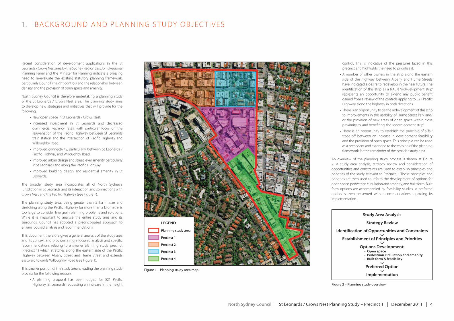
The broader study area incorporates all of North Sydney’s jurisdiction in St Leonards and its interaction and connections with Crows Nest and the Pacific Highway (see Figure 1).
The planning study area, being greater than 21ha in size and stretching along the Pacific Highway for more than a kilometre, is too large to consider fine grain planning problems and solutions. While it is important to analyse the entire study area and its surrounds, Council has adopted a precinct-based approach to ensure focused analysis and recommendations.
This document therefore gives a general analysis of the study area and its context and provides a more focused analysis and specific recommendations relating to a smaller planning study precinct (Precinct 1) which stretches along the eastern side of the Pacific Highway between Albany Street and Hume Street and extends eastward towards Willoughby Road (see Figure 1).
This smaller portion of the study area is leading the planning study process for the following reasons:
•A planning proposal has been lodged for 521 PacificHighway,StLeonardsrequestinganincreaseintheheight
control. This is indicative of the pressures faced in this precinct and highlights the need to prioritise it.
•A number of other owners in the strip along the easternside of the highway between Albany and Hume Streets have indicated a desire to redevelop in the near future. The identification of this strip as a future ‘redevelopment strip’ represents an opportunity to extend any public benefit gainedfromareviewofthecontrolsapplyingto521PacificHighway along the highway in both directions.
•Thereisanopportunitytotietheredevelopmentofthisstripto improvements in the usability of Hume Street Park and/or the provision of new areas of open space within close proximity to, and benefiting, the ‘redevelopment strip’.
•There is anopportunity toestablish theprincipleof a fairtrade-off between an increase in development feasibility and the provision of open space. This principle can be used as a precedent and extended to the revision of the planning framework for the remainder of the broader study area.
An overview of the planning study process is shown at Figure 2. A study area analysis, strategy review and consideration of opportunities and constraints are used to establish principles and priorities of the study relevant to Precinct 1. Those principles and priorities are then used to inform the development of options for open space, pedestrian circulation and amenity, and built form. Built form options are accompanied by feasibility studies. A preferred option is then presented with recommendations regarding its implementation.
figure 1 – planning study area map
figure 2 – planning study overview
Planning study area
Legend
Precinct 1
Precinct 2
Precinct 3
Precinct 4
Study Area Analysis+
Strategy review+
identification of opportunities and constraints
establishment of principles and priorities
options development:• Open space• Pedestrian circulation and amenity• Built form & feasibility
preferred option
implementation
north Sydney council | St Leonards / crows nest planning Study – precinct 1 | december 2011 | 5
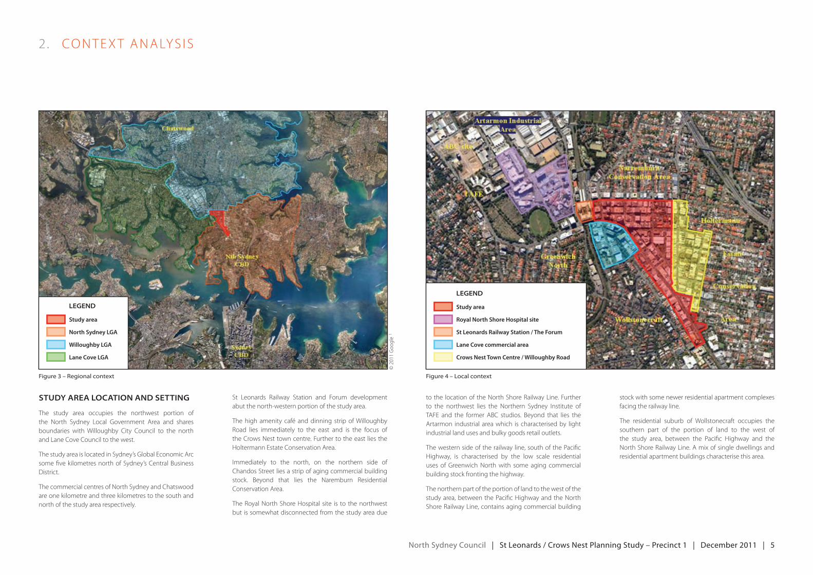
Study AreA LocAtion And Setting
The study area occupies the northwest portion of the North Sydney Local Government Area and shares boundaries with Willoughby City Council to the north and Lane Cove Council to the west.
The study area is located in Sydney’s Global economic Arc some five kilometres north of Sydney’s Central Business District.
The commercial centres of North Sydney and Chatswood are one kilometre and three kilometres to the south and north of the study area respectively.
St Leonards Railway Station and Forum development abut the north-western portion of the study area.
The high amenity café and dinning strip of Willoughby Road lies immediately to the east and is the focus of the Crows Nest town centre. Further to the east lies the Holtermann estate Conservation Area.
Immediately to the north, on the northern side ofChandos Street lies a strip of aging commercial building stock. Beyond that lies the Naremburn Residential Conservation Area.
The Royal North Shore Hospital site is to the northwest but is somewhat disconnected from the study area due
to the location of the North Shore Railway Line. Further to the northwest lies the Northern Sydney Institute ofTAFe and the former ABC studios. Beyond that lies the Artarmon industrial area which is characterised by light industrial land uses and bulky goods retail outlets.
The western side of the railway line, south of the Pacific Highway, is characterised by the low scale residential uses of Greenwich North with some aging commercial building stock fronting the highway.
The northern part of the portion of land to the west of the study area, between the Pacific Highway and the North Shore Railway Line, contains aging commercial building
stock with some newer residential apartment complexes facing the railway line.
The residential suburb of Wollstonecraft occupies the southern part of the portion of land to the west of the study area, between the Pacific Highway and the North Shore Railway Line. A mix of single dwellings and residential apartment buildings characterise this area.
2 . CoNTexT ANALyS IS
figure 3 – regional context figure 4 – local context
Legend
Study area
North Sydney LGA
Willoughby LGA
Lane Cove LGA
Study area
Legend
Royal North Shore Hospital site
St Leonards Railway Station / The Forum
Lane Cove commercial area
Crows Nest Town Centre / Willoughby Road
©2011goo
gle
1
north Sydney council | St Leonards / crows nest planning Study – precinct 1 | december 2011 | 6
2 . CoNTexT ANALyS IS
trAnSport
St Leonards is well serviced by rail, bus and active transport.
rAiL
St Leonards Railway Station, which lies immediately north west of study area, is on the North Shore Railway Line. The railway line connects the study area with the residential stations of Wollstonecraft and Waverton to the south before continuing on to the major employment areas of Global Sydney, accessed viathestationsofNorthSydney,milsonsPoint,Wynyard, Town Hall and Central.
To the north the railway line connects the study area to the stations of Artarmon and the employment and residential centre of Chatswood. From Chatswood, connections to the town centres of the upper north shore as wellas tomacquarieParkandeppingprovideadditional access to employment centres.
BuS
Sydney Buses provides services to the North Sydney and Sydney CBDs to the south as well asnorthtoChatswood.Inaddition,servicesarealso available that connect the study area to themilitary road corridor and beyond to theNorthern Beaches.
Active trAnSport
The study area is able to be accessed by bicycle using a number of marked on-road cycle routes that connect to nearby residential areas. While some links provide bicycle access for origins and destinations further afield, there is no comprehensive regional cycling network serving the study area. The yet to be commenced Naremburn to Harbour Bridge cycleway project has the potential to greatly enhance regional scale active transport opportunities to and from the study area.
privAte vehicLe
The Pacific Highway is the principal means of vehicularaccesstoandfromthestudyarea. Itconnects the study area to the North Sydney CBD to the south and beyond to the Harbour Bridge and Sydney CBD. To the north, the Highway connects the study area to Chatswood and beyond to the F3.
InadditiontothePacificHighway,FalconStreetacts as connector to the Warringah Freeway to the east. The Freeway leads to the Harbour Bridge in the south and the Lane Cove Tunnel andm2tothenorthwest.riverroadviaShirleyRoad provides access west to the Lane Cove Council area and beyond.
figure 5 – City rail network map extract figure 7 – north sydney bike map extract
figure 6 – sydney buses northern region map extract figure 8 – road network
Legend
Study area
Legend
Study area
Legend
Study area
On-Road Marked Bike Route
Off-Road Bike Route/Shared Path
Suggested Unmarked Bike Route
©2011google1
north Sydney council | St Leonards / crows nest planning Study – precinct 1 | december 2011 | 7
2 . CoNTexT ANALyS IS
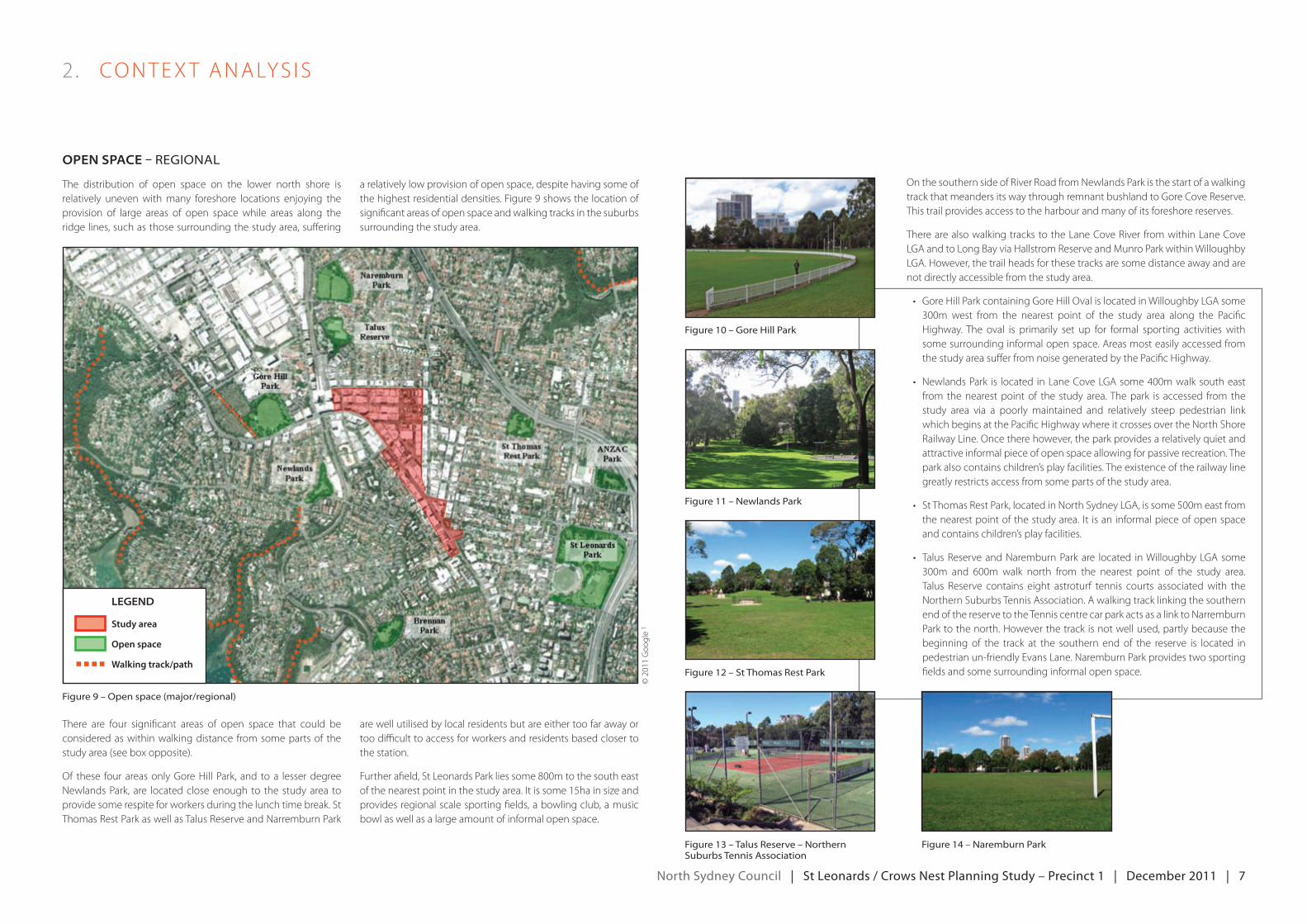
open SpAce – regional
The distribution of open space on the lower north shore is relatively uneven with many foreshore locations enjoying the provision of large areas of open space while areas along the ridge lines, such as those surrounding the study area, suffering
a relatively low provision of open space, despite having some of the highest residential densities. Figure 9 shows the location of significant areas of open space and walking tracks in the suburbs surrounding the study area.
There are four significant areas of open space that could be considered as within walking distance from some parts of the study area (see box opposite).
Of these four areas only Gore Hill Park, and to a lesser degree Newlands Park, are located close enough to the study area to provide some respite for workers during the lunch time break. St Thomas Rest Park as well as Talus Reserve and Narremburn Park
are well utilised by local residents but are either too far away or too difficult to access for workers and residents based closer to the station.
Furtherafield,StLeonardsParkliessome800mtothesoutheastofthenearestpointinthestudyarea.Itissome15hainsizeandprovides regional scale sporting fields, a bowling club, a music bowl as well as a large amount of informal open space.
On the southern side of River Road from Newlands Park is the start of a walking track that meanders its way through remnant bushland to Gore Cove Reserve. This trail provides access to the harbour and many of its foreshore reserves.
There are also walking tracks to the Lane Cove River from within Lane Cove LgAandtoLongbayviaHallstromreserveandmunroParkwithinwilloughbyLGA. However, the trail heads for these tracks are some distance away and are not directly accessible from the study area.
• goreHillParkcontaininggoreHillovalislocatedinwilloughbyLgAsome300m west from the nearest point of the study area along the PacificHighway. The oval is primarily set up for formal sporting activities with some surrounding informal open space. Areas most easily accessed from the study area suffer from noise generated by the Pacific Highway.
• NewlandsPark is located inLaneCoveLgAsome400mwalksoutheastfrom the nearest point of the study area. The park is accessed from the study area via a poorly maintained and relatively steep pedestrian link which begins at the Pacific Highway where it crosses over the North Shore railwayLine.oncetherehowever,theparkprovidesarelativelyquietandattractive informal piece of open space allowing for passive recreation. The park also contains children’s play facilities. The existence of the railway line greatly restricts access from some parts of the study area.
• StThomasrestPark,locatedinNorthSydneyLgA,issome500meastfromthenearestpointofthestudyarea. It isaninformalpieceofopenspaceand contains children’s play facilities.
• TalusreserveandNaremburnParkare located inwilloughbyLgAsome300m and 600m walk north from the nearest point of the study area.Talus Reserve contains eight astroturf tennis courts associated with the Northern Suburbs Tennis Association. A walking track linking the southern end of the reserve to the Tennis centre car park acts as a link to Narremburn Park to the north. However the track is not well used, partly because the beginning of the track at the southern end of the reserve is located in pedestrian un-friendly evans Lane. Naremburn Park provides two sporting fields and some surrounding informal open space.
figure 9 – open space (major/regional)
figure 10 – gore hill park
figure 11 – newlands park
figure 12 – st thomas rest park
figure 13 – talus reserve – northern suburbs tennis association
figure 14 – naremburn park
Legend
Study area
Open space
Walking track/path
©2011goo
gle
1
north Sydney council | St Leonards / crows nest planning Study – precinct 1 | december 2011 | 8
2 . CoNTexT ANALyS IS
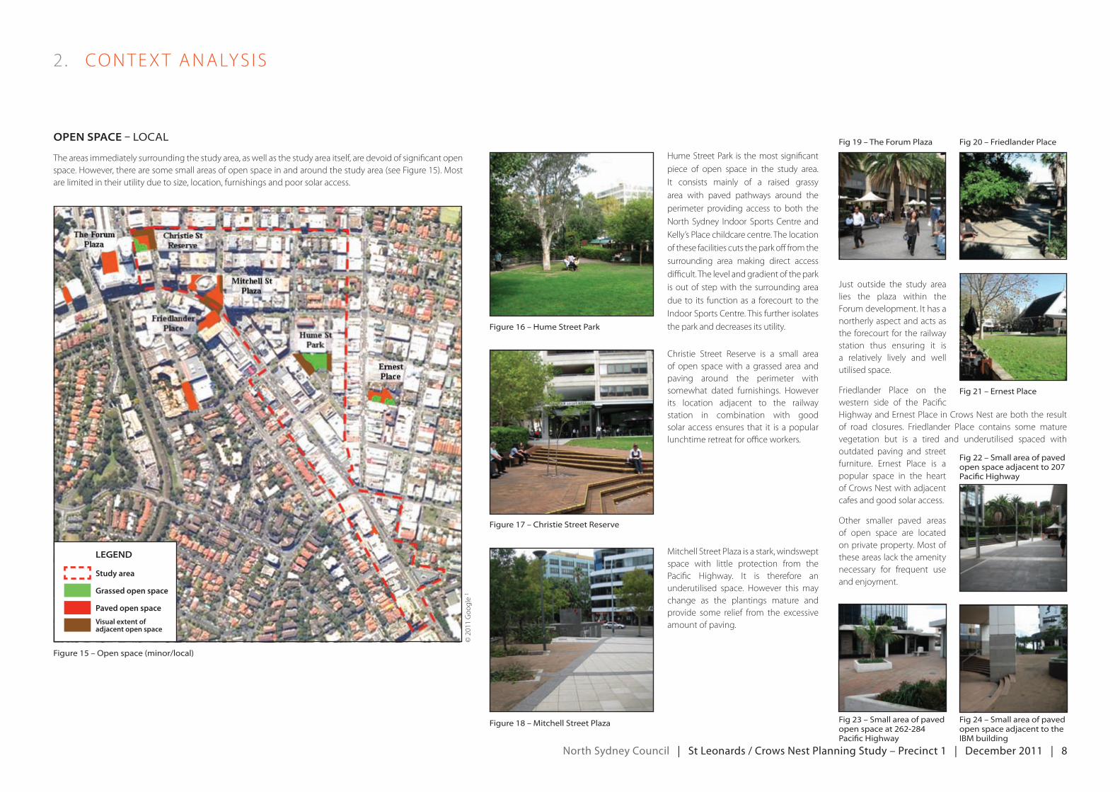
open SpAce – loCal
The areas immediately surrounding the study area, as well as the study area itself, are devoid of significant open space.However,therearesomesmallareasofopenspaceinandaroundthestudyarea(seeFigure15).mostare limited in their utility due to size, location, furnishings and poor solar access.
Hume Street Park is the most significant piece of open space in the study area. It consists mainly of a raised grassyarea with paved pathways around the perimeter providing access to both the North Sydney Indoor SportsCentre andKelly’s Place childcare centre. The location of these facilities cuts the park off from the surrounding area making direct access difficult. The level and gradient of the park is out of step with the surrounding area due to its function as a forecourt to the IndoorSportsCentre.Thisfurtherisolatesthe park and decreases its utility.
Christie Street Reserve is a small area of open space with a grassed area and paving around the perimeter with somewhat dated furnishings. However its location adjacent to the railway station in combination with good solar access ensures that it is a popular lunchtime retreat for office workers.
mitchellStreetPlazaisastark,windsweptspace with little protection from the Pacific Highway. It is therefore anunderutilised space. However this may change as the plantings mature and provide some relief from the excessive amount of paving.
figure 16 – hume street park
figure 15 – open space (minor/local)
fig 19 – the forum plaza
fig 23 – small area of paved open space at 262-284 pacific highway
fig 20 – friedlander place
fig 21 – ernest place
fig 24 – small area of paved open space adjacent to the ibm building
figure 17 – Christie street reserve
figure 18 – mitchell street plaza
Legend
Study area
Grassed open space
Paved open space
Visual extent of adjacent open space
just outside the study arealies the plaza within the Forumdevelopment.Ithasanortherly aspect and acts as the forecourt for the railway station thus ensuring it is a relatively lively and well utilised space.
Friedlander Place on the western side of the Pacific Highway and ernest Place in Crows Nest are both the result of road closures. Friedlander Place contains some mature vegetation but is a tired and underutilised spaced with outdated paving and street furniture. ernest Place is a popular space in the heart of Crows Nest with adjacent cafes and good solar access.
Other smaller paved areas of open space are located onprivateproperty.mostofthese areas lack the amenity necessary for frequent useand enjoyment.
fig 22 – small area of paved open space adjacent to 207 pacific highway
©2011goo
gle
1
north Sydney council | St Leonards / crows nest planning Study – precinct 1 | december 2011 | 9
2 . CoNTexT ANALyS IS
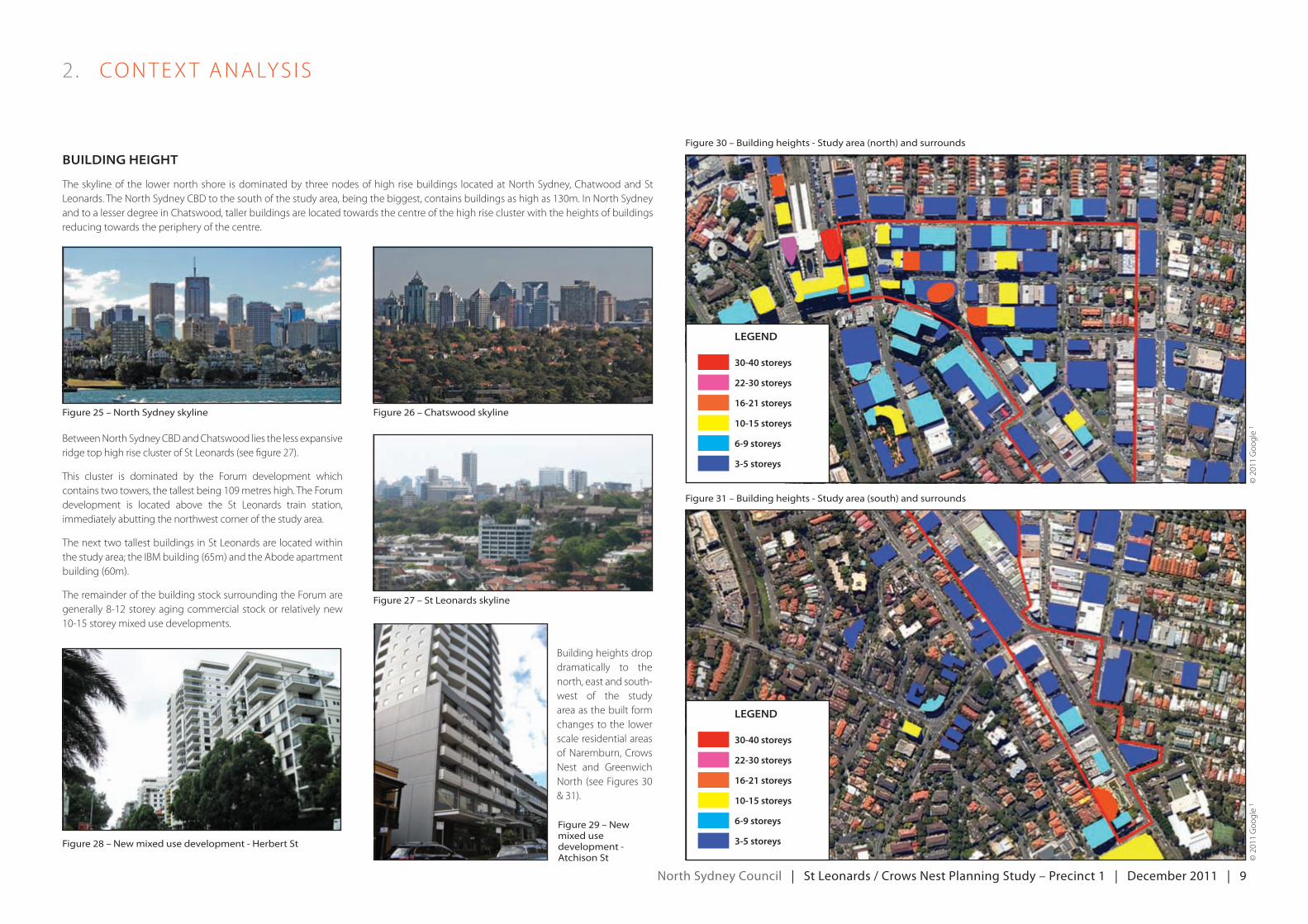
BuiLding height
The skyline of the lower north shore is dominated by three nodes of high rise buildings located at North Sydney, Chatwood and St Leonards.TheNorthSydneyCbdtothesouthofthestudyarea,beingthebiggest,containsbuildingsashighas130m.InNorthSydneyand to a lesser degree in Chatswood, taller buildings are located towards the centre of the high rise cluster with the heights of buildings reducing towards the periphery of the centre.
figure 25 – north sydney skyline
figure 28 – new mixed use development - herbert st
figure 29 – new mixed use development - atchison st
figure 26 – Chatswood skyline
figure 30 – building heights - study area (north) and surrounds
figure 31 – building heights - study area (south) and surrounds
figure 27 – st leonards skyline
Between North Sydney CBD and Chatswood lies the less expansive ridgetophighriseclusterofStLeonards(seefigure27).
This cluster is dominated by the Forum development which containstwotowers,thetallestbeing109metreshigh.TheForumdevelopment is located above the St Leonards train station, immediately abutting the northwest corner of the study area.
The next two tallest buildings in St Leonards are located within thestudyarea;theIbmbuilding(65m)andtheAbodeapartmentbuilding(60m).
The remainder of the building stock surrounding the Forum are generally 8-12 storey aging commercial stock or relatively new 10-15storeymixedusedevelopments.
Building heights drop dramatically to the north, east and south-west of the study area as the built form changes to the lower scale residential areas of Naremburn, Crows Nest and Greenwich North(seeFigures30& 31).
Legend
16-21 storeys
22-30 storeys
30-40 storeys
10-15 storeys
6-9 storeys
3-5 storeys
Legend
16-21 storeys
22-30 storeys
30-40 storeys
10-15 storeys
6-9 storeys
3-5 storeys
©2011goo
gle
1©2011goo
gle
1
north Sydney council | St Leonards / crows nest planning Study – precinct 1 | december 2011 | 10
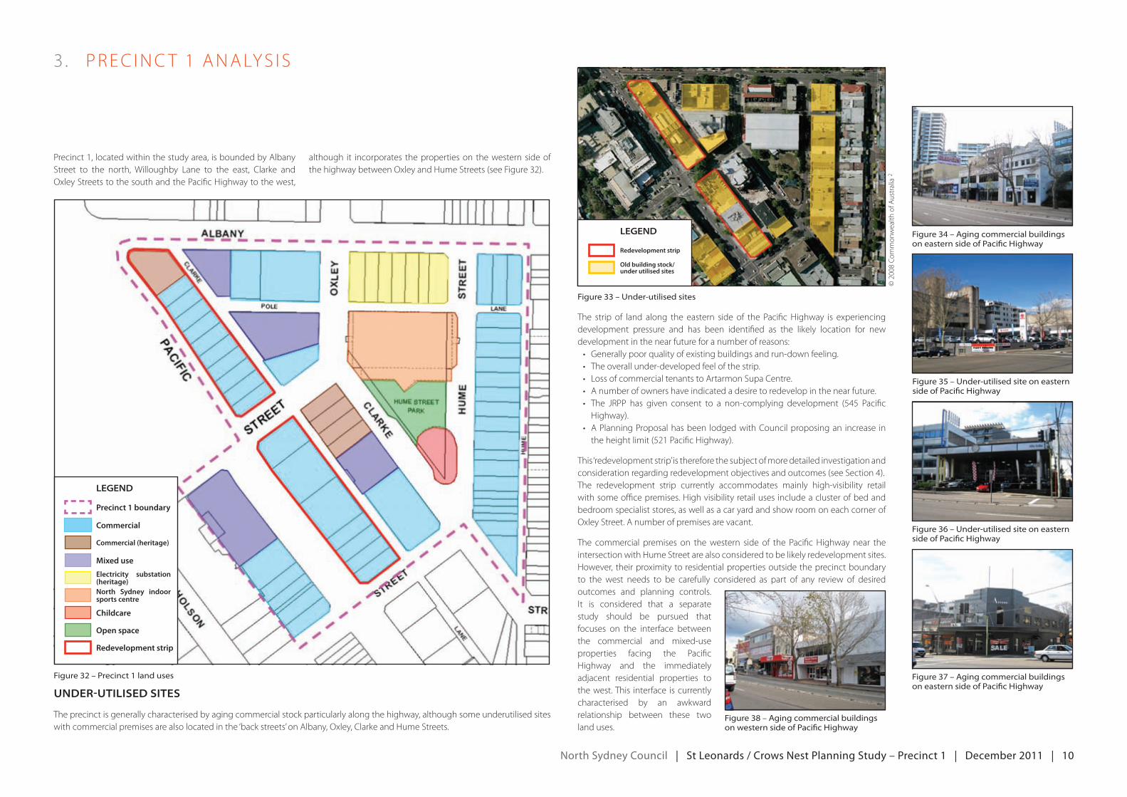
3 . PreC INC T 1 ANALyS IS
Precinct 1, located within the study area, is bounded by Albany Street to the north, Willoughby Lane to the east, Clarke and Oxley Streets to the south and the Pacific Highway to the west,
although it incorporates the properties on the western side of the highway between Oxley and Hume Streets (see Figure 32).
The strip of land along the eastern side of the Pacific Highway is experiencing development pressure and has been identified as the likely location for new development in the near future for a number of reasons:• generallypoorqualityofexistingbuildingsandrun-downfeeling.• Theoverallunder-developedfeelofthestrip.• LossofcommercialtenantstoArtarmonSupaCentre.• Anumberofownershaveindicatedadesiretoredevelopinthenearfuture.• The jrPP has given consent to a non-complying development (545 Pacific
Highway).• APlanningProposalhasbeen lodgedwithCouncilproposingan increase intheheightlimit(521PacificHighway).
This ‘redevelopment strip’ is therefore the subject of more detailed investigation and considerationregardingredevelopmentobjectivesandoutcomes(seeSection4).The redevelopment strip currently accommodates mainly high-visibility retail with some office premises. High visibility retail uses include a cluster of bed and bedroom specialist stores, as well as a car yard and show room on each corner of Oxley Street. A number of premises are vacant.
The commercial premises on the western side of the Pacific Highway near the intersection with Hume Street are also considered to be likely redevelopment sites. However, their proximity to residential properties outside the precinct boundary to the west needs to be carefully considered as part of any review of desired outcomes and planning controls. It is considered that a separatestudy should be pursued that focuses on the interface between the commercial and mixed-use properties facing the Pacific Highway and the immediately adjacent residential properties to the west. This interface is currently characterised by an awkward relationship between these two land uses.
figure 32 – precinct 1 land uses
figure 34 – aging commercial buildings on eastern side of pacific highway
figure 35 – under-utilised site on eastern side of pacific highway
figure 36 – under-utilised site on eastern side of pacific highway
figure 37 – aging commercial buildings on eastern side of pacific highway
figure 38 – aging commercial buildings on western side of pacific highway
Legend
Precinct 1 boundary
Childcare
North Sydney indoor sports centre
Electricity substation (heritage)
Mixed use
Commercial (heritage)
Commercial
Open space
Redevelopment strip
figure 33 – under-utilised sites
Legend
Redevelopment strip
Old building stock/ under utilised sites
under-utiLiSed SiteS
The precinct is generally characterised by aging commercial stock particularly along the highway, although some underutilised sites with commercial premises are also located in the ‘back streets’ on Albany, Oxley, Clarke and Hume Streets.
©2008Co
mmon
wealth
ofA
ustralia
2

north Sydney council | St Leonards / crows nest planning Study – precinct 1 | december 2011 | 11
3 . PreC INC T 1 ANALyS IS
new deveLopmentS
There are four relatively new strata titled mixed use developments in the precinct that are largely residential in nature with commercial uses mostly restricted to the ground floor (refer to Figure 32 for locations). These developments have been approved under existing controls, however concerns have been expressed by Council staff regarding the resultant design and residential amenity outcomes.
heritAge
Theprecinctcontainsthreeheritageitems:theoldmarcobuilding;theStLeonardsCentre;andtheelectricitySubstationbuildingonthecornerofoxleyandAlbanyStreets.AccordingtoCouncil’sheritagedatasheet,theoldmarcobuilding,whichis located on the corner of Albany Street and the Pacific Highway, is a:
‘three storey triangular building with curved facade to the street corner and rectangular projecting tower bay asymmetric on one side. Projecting cornice lines to parapets and short flat continuous cantilevered rain hoods over continuous lines of steel-framed windows are features. This building is designed in the Inter-War Functionalist style’.
The data sheet adds that the building is an ‘excellent and attractive example of the Interwar Functionalist style on a prominent corner site’. The building currently accommodates a ‘Sleep City’ retail outlet.
figure 39 – mixed use development on albany street
figure 40 – mixed use development on oxley street
figure 41 – mixed use development on Clarke street
figure 42 – mixed use development on western side of pacific highway
figure 45 – the electricity substation building
figure 43 – the old marco building
figure 44 – the st leonards Centre building
Council’s heritage data sheet on the St Leonards Centre describes the item, which is located on the corner of Oxley and Clarke Streets, as a:
‘dramatically assertive building marked by curvilinear plan bastion tower elements of textured off form reinforced concrete. Between these the storeys step outwards towards the top, bestowing upon the structure a character of great and not totally pleasant strength. It is a well-made and crafted building designed in the late twentieth century brutalist style’.
The data sheet adds that the buildings ‘domineering presence and intrusive character is barely balanced by its intrinsic architectural interest’. The building contains private commercial tenancies.
The third heritage item is the electricity substation building on the corner of Albany and Oxley Streets. Council’s heritage data sheet on the item describes the building as a:
‘two storey cement rendered substation building with hipped gable terracotta tiled roof above a face brick foundation course. Facade to Albany Street is articulated with five recessed, semi-circular arched panels containing large twelve pane windows to each level, between projecting end bays having half-hipped gable ends at the roof line and with the same semi-circular recessed panel. Oxley Street facade is similar but asymmetric with projecting bay to one side only. This building was designed in the Inter-War Georgian Revival style’.
The data sheet adds that the building is an ‘important original element in urban infrastructure which is a substantial and impressive building exhibiting careful and well balanced Georgian detailing. Evidence of a period design ethic now absent from public utilities’. The substation is still in use and has recently undergone an upgrade and expansion.
north Sydney council | St Leonards / crows nest planning Study – precinct 1 | december 2011 | 12
3 . PreC INC T 1 ANALyS IS
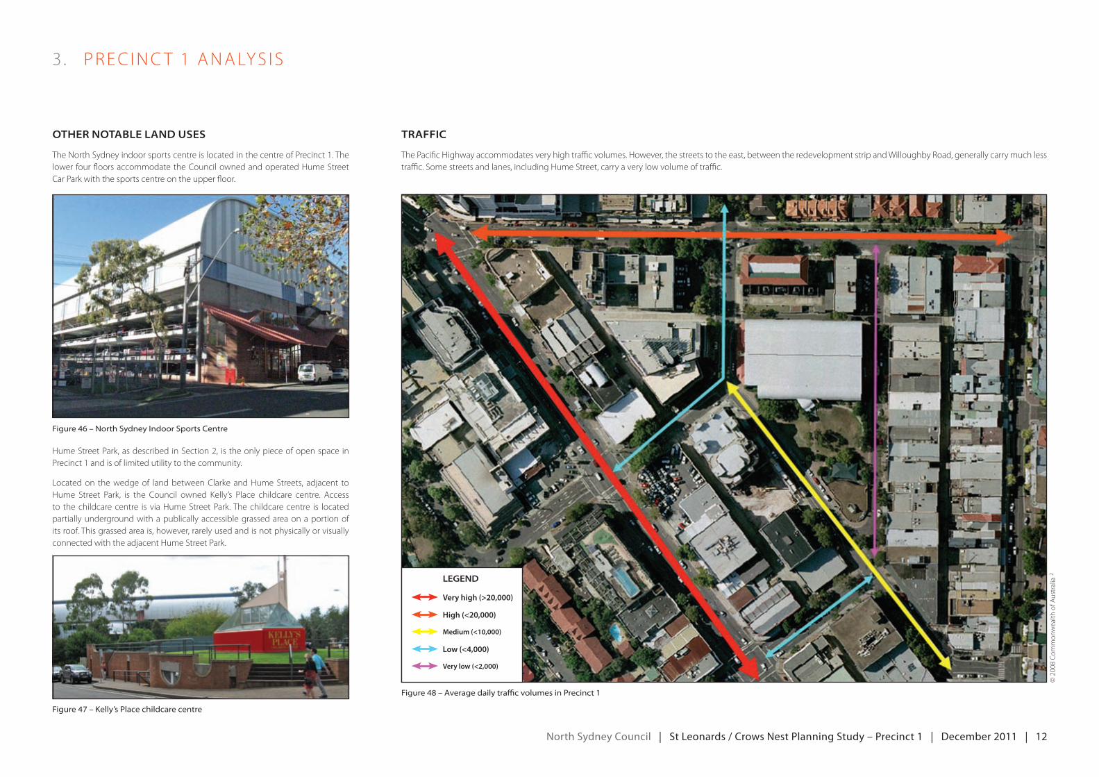
other notABLe LAnd uSeS
The North Sydney indoor sports centre is located in the centre of Precinct 1. The lower four floors accommodate the Council owned and operated Hume Street Car Park with the sports centre on the upper floor.
Hume Street Park, as described in Section 2, is the only piece of open space in Precinct 1 and is of limited utility to the community.
Located on the wedge of land between Clarke and Hume Streets, adjacent to Hume Street Park, is the Council owned Kelly’s Place childcare centre. Access to the childcare centre is via Hume Street Park. The childcare centre is located partially underground with a publically accessible grassed area on a portion of its roof. This grassed area is, however, rarely used and is not physically or visually connected with the adjacent Hume Street Park.
trAffic
The Pacific Highway accommodates very high traffic volumes. However, the streets to the east, between the redevelopment strip and Willoughby Road, generally carry much less traffic. Some streets and lanes, including Hume Street, carry a very low volume of traffic.
figure 46 – north sydney indoor sports Centre
figure 47 – kelly’s place childcare centre
figure 48 – average daily traffic volumes in precinct 1
Legend
Very high (>20,000)
Very low (<2,000)
Low (<4,000)
Medium (<10,000)
High (<20,000)
©2008Co
mmon
wealth
ofA
ustralia
2
north Sydney council | St Leonards / crows nest planning Study – precinct 1 | december 2011 | 13
4 . redeveLoPmeNTSTr IP ANALyS IS
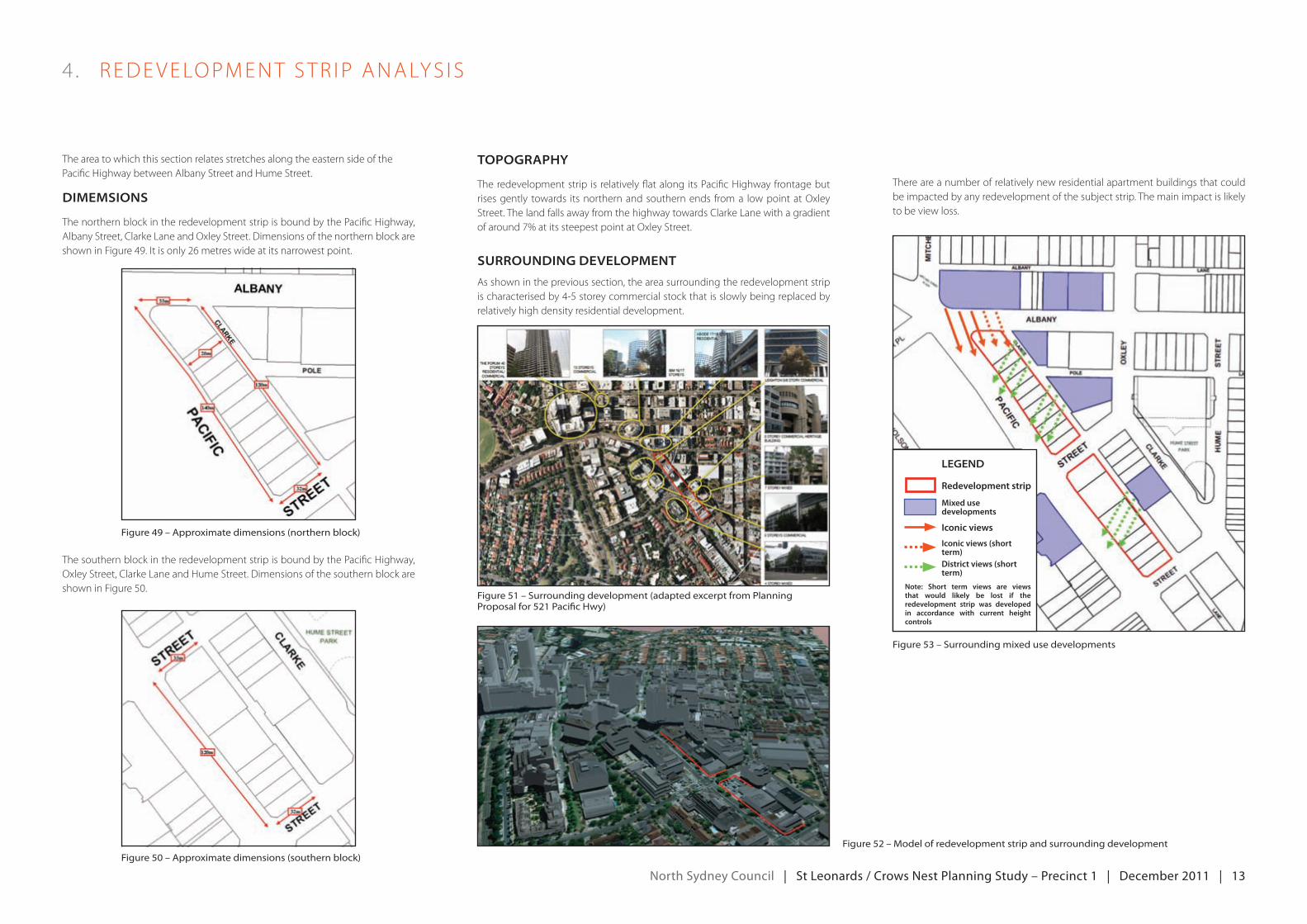
The area to which this section relates stretches along the eastern side of the Pacific Highway between Albany Street and Hume Street.
dimemSionS
The northern block in the redevelopment strip is bound by the Pacific Highway, Albany Street, Clarke Lane and Oxley Street. Dimensions of the northern block are showninFigure49.Itisonly26metreswideatitsnarrowestpoint.
The southern block in the redevelopment strip is bound by the Pacific Highway, Oxley Street, Clarke Lane and Hume Street. Dimensions of the southern block are showninFigure50.
topogrAphy
The redevelopment strip is relatively flat along its Pacific Highway frontage but rises gently towards its northern and southern ends from a low point at Oxley Street. The land falls away from the highway towards Clarke Lane with a gradient ofaround7%atitssteepestpointatoxleyStreet.
Surrounding deveLopment
As shown in the previous section, the area surrounding the redevelopment strip ischaracterisedby4-5storeycommercialstockthatisslowlybeingreplacedbyrelatively high density residential development.
There are a number of relatively new residential apartment buildings that could be impacted by any redevelopment of the subject strip. The main impact is likely to be view loss.
figure 49 – approximate dimensions (northern block)
figure 51 – surrounding development (adapted excerpt from planning proposal for 521 pacific hwy)
figure 53 – surrounding mixed use developments
figure 52 – model of redevelopment strip and surrounding developmentfigure 50 – approximate dimensions (southern block)
Legend
Redevelopment strip
Mixed use developments
Iconic views
Iconic views (short term)District views (short term)
Note: Short term views are views that would likely be lost if the redevelopment strip was developed in accordance with current height controls
north Sydney council | St Leonards / crows nest planning Study – precinct 1 | december 2011 | 14
4 . redeveLoPmeNTSTr IP ANALyS IS
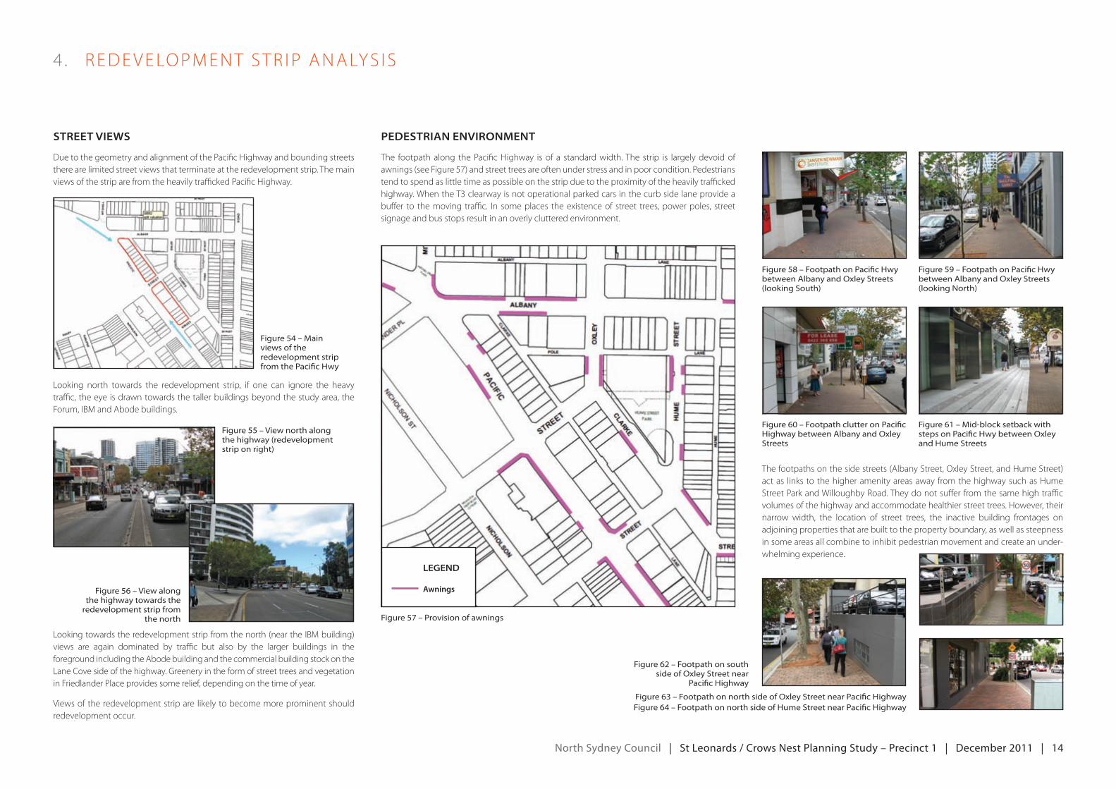
Street viewS
Due to the geometry and alignment of the Pacific Highway and bounding streets there are limited street views that terminate at the redevelopment strip. The main views of the strip are from the heavily trafficked Pacific Highway.
figure 58 – footpath on pacific hwy between albany and oxley streets (looking south)
figure 60 – footpath clutter on pacific highway between albany and oxley streets
figure 59 – footpath on pacific hwy between albany and oxley streets (looking north)
figure 61 – mid-block setback with steps on pacific hwy between oxley and hume streets
figure 57 – provision of awnings
figure 56 – view along the highway towards the
redevelopment strip from the north
figure 54 – main views of the redevelopment strip from the pacific hwy
figure 55 – view north along the highway (redevelopment strip on right)
Looking north towards the redevelopment strip, if one can ignore the heavy traffic, the eye is drawn towards the taller buildings beyond the study area, the Forum,IbmandAbodebuildings.
The footpaths on the side streets (Albany Street, Oxley Street, and Hume Street) act as links to the higher amenity areas away from the highway such as Hume Street Park and Willoughby Road. They do not suffer from the same high traffic volumes of the highway and accommodate healthier street trees. However, their narrow width, the location of street trees, the inactive building frontages on adjoining properties that are built to the property boundary, as well as steepness in some areas all combine to inhibit pedestrian movement and create an under-whelming experience.
pedeStriAn environment
The footpath along the Pacific Highway is of a standard width. The strip is largely devoid of awnings(seeFigure57)andstreettreesareoftenunderstressandinpoorcondition.Pedestrianstend to spend as little time as possible on the strip due to the proximity of the heavily trafficked highway. When the T3 clearway is not operational parked cars in the curb side lane provide a buffer to themoving traffic. In someplaces theexistenceof street trees,powerpoles, streetsignage and bus stops result in an overly cluttered environment.
Lookingtowardstheredevelopmentstripfromthenorth(neartheIbmbuilding)views are again dominated by traffic but also by the larger buildings in the foreground including the Abode building and the commercial building stock on the Lane Cove side of the highway. Greenery in the form of street trees and vegetation in Friedlander Place provides some relief, depending on the time of year.
viewsoftheredevelopmentstripare likelytobecomemoreprominentshouldredevelopment occur.
Legend
Awnings
figure 62 – footpath on south side of oxley street near
pacific highway
figure 63 – footpath on north side of oxley street near pacific highwayfigure 64 – footpath on north side of hume street near pacific highway
north Sydney council | St Leonards / crows nest planning Study – precinct 1 | december 2011 | 15
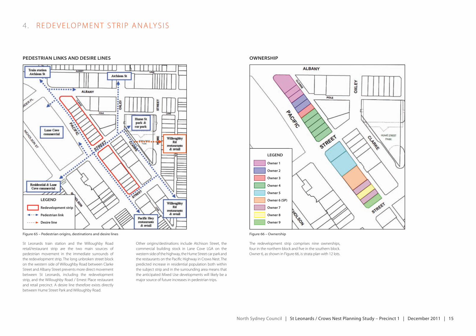
St Leonards train station and the Willoughby Road retail/restaurant strip are the two main sources of pedestrian movement in the immediate surrounds of the redevelopment strip. The long unbroken street block on the western side of Willoughby Road between Clarke Street and Albany Street prevents more direct movement between St Leonards, including the redevelopment strip, and the Willoughby Road / ernest Place restaurant and retail precinct. A desire line therefore exists directly between Hume Street Park and Willoughby Road.
Other origins/destinations include Atchison Street, the commercial building stock in Lane Cove LGA on the western side of the highway, the Hume Street car park and the restaurants on the Pacific Highway in Crows Nest. The predicted increase in residential population both within the subject strip and in the surrounding area means that theanticipatedmixedusedevelopmentswill likelybeamajor source of future increases in pedestrian trips.
The redevelopment strip comprises nine ownerships, four in the northern block and five in the southern block. Owner 6, as shown in Figure 66, is strata plan with 12 lots.
4 . redeveLoPmeNTSTr IP ANALyS IS
figure 65 – pedestrian origins, destinations and desire lines figure 66 – ownership
pedeStriAn LinkS And deSire LineS ownerShip
Legend
Redevelopment strip
Pedestrian link
Desire line
Legend
Owner 1
Owner 7
Owner 6 (SP)
Owner 5
Owner 4
Owner 3
Owner 2
Owner 8
Owner 9
north Sydney council | St Leonards / crows nest planning Study – precinct 1 | december 2011 | 16
4 . redeveLoPmeNTSTr IP ANALyS IS
deveLopment AppLicAtionS And pLAnning propoSALS
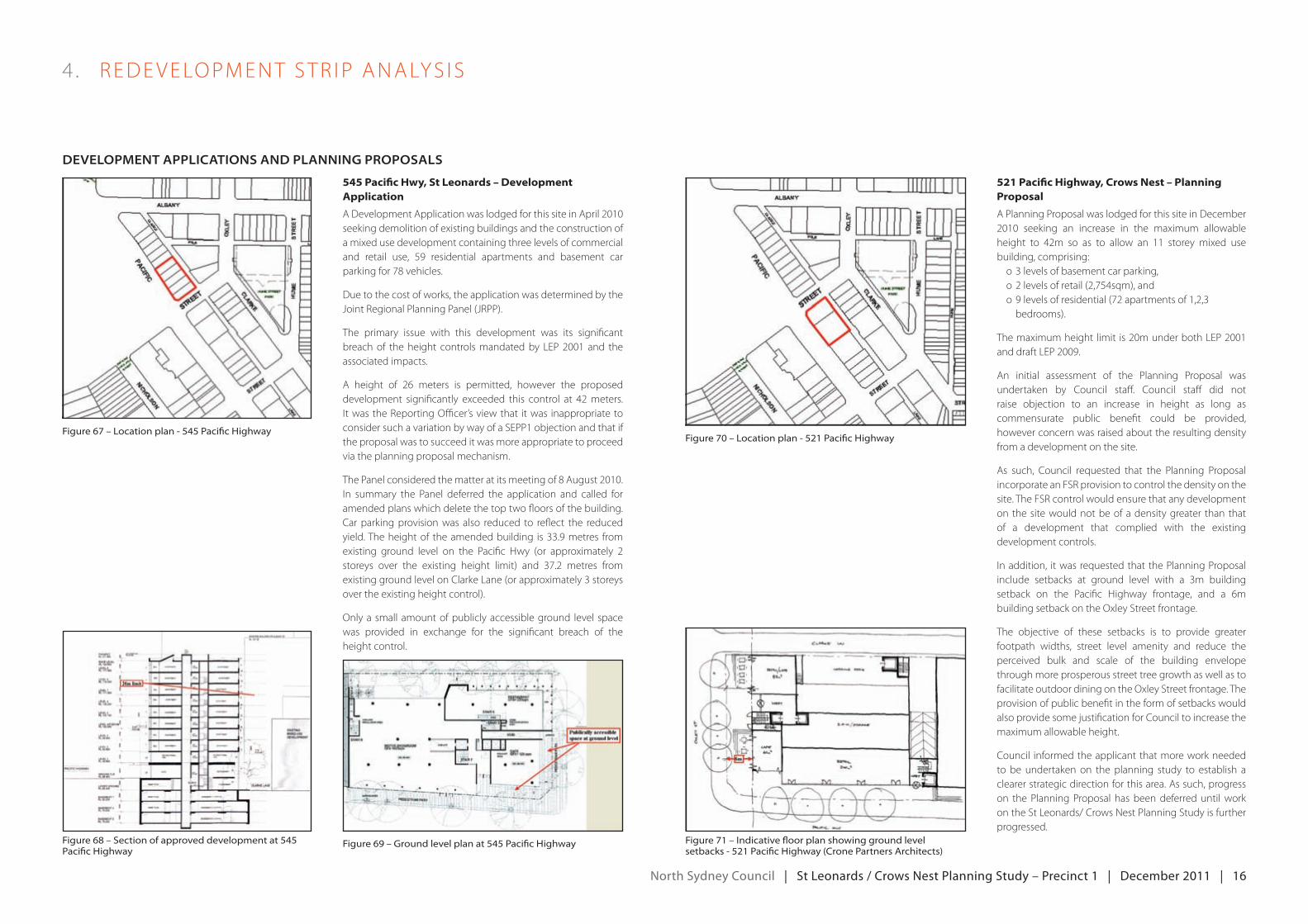
545 Pacific Hwy, St Leonards – Development Application
AdevelopmentApplicationwaslodgedforthissiteinApril2010seeking demolition of existing buildings and the construction of a mixed use development containing three levels of commercial and retail use, 59 residential apartments and basement carparkingfor78vehicles.
Due to the cost of works, the application was determined by the jointregionalPlanningPanel(jrPP).
The primary issue with this development was its significant breachof theheight controlsmandatedby LeP2001 and theassociated impacts.
A height of 26 meters is permitted, however the proposed development significantly exceeded this control at 42meters.Itwasthereportingofficer’sviewthat itwas inappropriatetoconsider such a variation by way of a SePP1 objection and that if the proposal was to succeed it was more appropriate to proceed via the planning proposal mechanism.
ThePanelconsideredthematteratitsmeetingof8August2010.In summary the Panel deferred the application and called foramended plans which delete the top two floors of the building. Car parking provision was also reduced to reflect the reduced yield. The height of the amended building is 33.9 metres from existing ground level on the Pacific Hwy (or approximately 2 storeys over the existing height limit) and 37.2 metres fromexisting ground level on Clarke Lane (or approximately 3 storeys over the existing height control).
Only a small amount of publicly accessible ground level space was provided in exchange for the significant breach of the height control.
521 Pacific Highway, Crows Nest – Planning Proposal
A Planning Proposal was lodged for this site in December 2010 seeking an increase in the maximum allowableheight to 42m so as to allow an 11 storey mixed usebuilding, comprising:
o 3 levels of basement car parking,o2levelsofretail(2,754sqm),ando9levelsofresidential(72apartmentsof1,2,3
bedrooms).
Themaximumheightlimit is20munderbothLeP2001anddraftLeP2009.
An initial assessment of the Planning Proposal was undertaken by Council staff. Council staff did not raise objection to an increase in height as long as commensurate public benefit could be provided, however concern was raised about the resulting density from a development on the site.
As such, Council requested that the Planning Proposalincorporate an FSR provision to control the density on the site. The FSR control would ensure that any development on the site would not be of a density greater than that of a development that complied with the existing development controls.
Inaddition, itwasrequestedthatthePlanningProposalinclude setbacks at ground level with a 3m building setback on the Pacific Highway frontage, and a 6m building setback on the Oxley Street frontage.
The objective of these setbacks is to provide greater footpath widths, street level amenity and reduce the perceived bulk and scale of the building envelope through more prosperous street tree growth as well as to facilitate outdoor dining on the Oxley Street frontage. The provision of public benefit in the form of setbacks would also provide some justification for Council to increase the maximum allowable height.
Council informed the applicant that more work needed to be undertaken on the planning study to establish a clearer strategic direction for this area. As such, progress on the Planning Proposal has been deferred until work on the St Leonards/ Crows Nest Planning Study is further progressed.
figure 67 – location plan - 545 pacific highwayfigure 70 – location plan - 521 pacific highway
figure 68 – section of approved development at 545 pacific highway
figure 71 – indicative floor plan showing ground level setbacks - 521 pacific highway (Crone partners architects)
figure 69 – ground level plan at 545 pacific highway
north Sydney council | St Leonards / crows nest planning Study – precinct 1 | december 2011 | 17
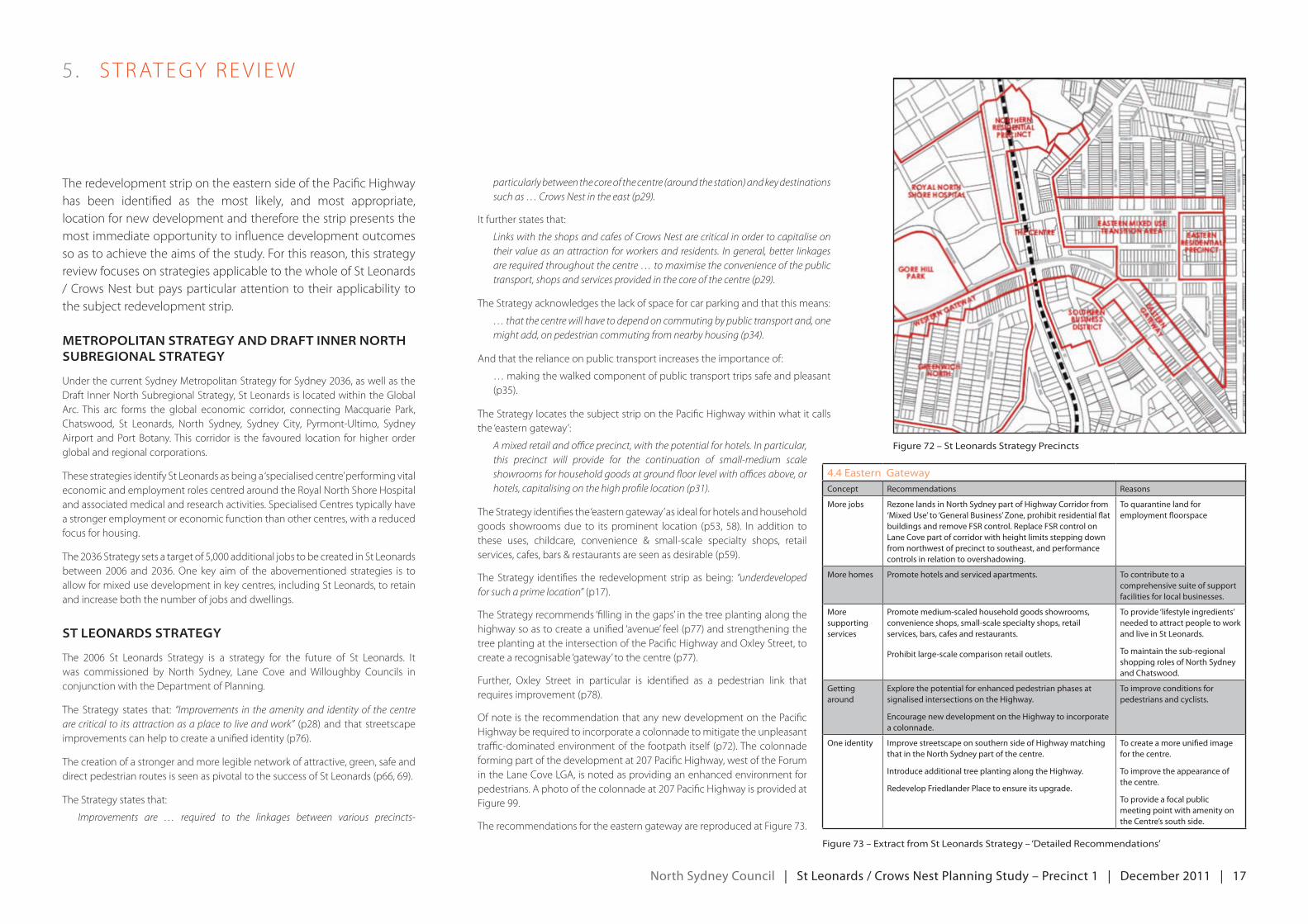
The redevelopment strip on the eastern side of the Pacific Highway has been identified as the most likely, and most appropriate, location for new development and therefore the strip presents the most immediate opportunity to influence development outcomes so as to achieve the aims of the study. For this reason, this strategy review focuses on strategies applicable to the whole of St Leonards / Crows Nest but pays particular attention to their applicability to the subject redevelopment strip.
metropoLitAn StrAtegy And drAft inner north SuBregionAL StrAtegy
underthecurrentSydneymetropolitanStrategyforSydney2036,aswellasthedraftInnerNorthSubregionalStrategy,StLeonardsislocatedwithintheglobalArc. This arc forms the global economic corridor, connectingmacquarie Park,Chatswood, St Leonards, North Sydney, Sydney City, Pyrmont-Ultimo, Sydney Airport and Port Botany. This corridor is the favoured location for higher order global and regional corporations.
These strategies identify St Leonards as being a ‘specialised centre’ performing vital economic and employment roles centred around the Royal North Shore Hospital and associated medical and research activities. Specialised Centres typically have a stronger employment or economic function than other centres, with a reduced focus for housing.
The2036Strategysetsatargetof5,000additionaljobstobecreatedinStLeonardsbetween2006 and2036.one key aimof the abovementioned strategies is toallow for mixed use development in key centres, including St Leonards, to retain and increase both the number of jobs and dwellings.
St LeonArdS StrAtegy
The 2006 St Leonards Strategy is a strategy for the future of St Leonards. Itwas commissioned by North Sydney, Lane Cove and Willoughby Councils in conjunction with the Department of Planning.
The Strategy states that: “Improvements in the amenity and identity of the centre are critical to its attraction as a place to live and work” (p28) and that streetscape improvementscanhelptocreateaunifiedidentity(p76).
The creation of a stronger and more legible network of attractive, green, safe and direct pedestrian routes is seen as pivotal to the success of St Leonards (p66, 69).
The Strategy states that:
Improvements are … required to the linkages between various precincts-
5 . STrATegyrev Iew
particularly between the core of the centre (around the station) and key destinations such as … Crows Nest in the east (p29).
Itfurtherstatesthat:
Links with the shops and cafes of Crows Nest are critical in order to capitalise on their value as an attraction for workers and residents. In general, better linkages are required throughout the centre … to maximise the convenience of the public transport, shops and services provided in the core of the centre (p29).
The Strategy acknowledges the lack of space for car parking and that this means:
… that the centre will have to depend on commuting by public transport and, one might add, on pedestrian commuting from nearby housing (p34).
And that the reliance on public transport increases the importance of:
… making the walked component of public transport trips safe and pleasant (p35).
The Strategy locates the subject strip on the Pacific Highway within what it calls the ‘eastern gateway’:
A mixed retail and office precinct, with the potential for hotels. In particular, this precinct will provide for the continuation of small-medium scale showrooms for household goods at ground floor level with offices above, or hotels, capitalising on the high profile location (p31).
The Strategy identifies the ‘eastern gateway’ as ideal for hotels and household goods showroomsdue to itsprominent location (p53,58). Inaddition tothese uses, childcare, convenience & small-scale specialty shops, retail services,cafes,bars&restaurantsareseenasdesirable(p59).
The Strategy identifies the redevelopment strip as being: “underdeveloped for such a prime location”(p17).
The Strategy recommends ‘filling in the gaps’ in the tree planting along the highwaysoastocreateaunified‘avenue’feel(p77)andstrengtheningthetree planting at the intersection of the Pacific Highway and Oxley Street, to createarecognisable‘gateway’tothecentre(p77).
Further, Oxley Street in particular is identified as a pedestrian link that requiresimprovement(p78).
Of note is the recommendation that any new development on the Pacific Highwayberequiredtoincorporateacolonnadetomitigatetheunpleasanttraffic-dominatedenvironmentofthefootpathitself (p72).Thecolonnadeformingpartofthedevelopmentat207PacificHighway,westoftheForumin the Lane Cove LGA, is noted as providing an enhanced environment for pedestrians.Aphotoofthecolonnadeat207PacificHighwayisprovidedatFigure 99.
TherecommendationsfortheeasterngatewayarereproducedatFigure73.
figure 72 – st leonards strategy precincts
figure 73 – extract from st leonards strategy – ‘Detailed recommendations’
4.4 eastern gatewayconcept recommendations reasons
more jobs rezone lands in north Sydney part of Highway corridor from ‘mixed use’ to ‘general business’ Zone, prohibit residential flat buildings and remove FSr control. replace FSr control on Lane cove part of corridor with height limits stepping down from northwest of precinct to southeast, and performance controls in relation to overshadowing.
to quarantine land for employment floorspace
more homes promote hotels and serviced apartments. to contribute to a comprehensive suite of support facilities for local businesses.
more supporting services
promote medium-scaled household goods showrooms, convenience shops, small-scale specialty shops, retail services, bars, cafes and restaurants.
prohibit large-scale comparison retail outlets.
to provide ‘lifestyle ingredients’ needed to attract people to work and live in St Leonards.
to maintain the sub-regional shopping roles of north Sydney and chatswood.
getting around
explore the potential for enhanced pedestrian phases at signalised intersections on the Highway.
encourage new development on the Highway to incorporate a colonnade.
to improve conditions for pedestrians and cyclists.
one identity improve streetscape on southern side of Highway matching that in the north Sydney part of the centre.
introduce additional tree planting along the Highway.
redevelop Friedlander place to ensure its upgrade.
to create a more unified image for the centre.
to improve the appearance of the centre.
to provide a focal public meeting point with amenity on the centre’s south side.

north Sydney council | St Leonards / crows nest planning Study – precinct 1 | december 2011 | 18
5 . STrATegyrev Iew
north Sydney LocAL environmentAL pLAn 2001 (Lep 2001)
figure 75 – lep 2001 height and non-residential fsr
figure 76 – lep 2001 heritage
ALBANY
PACIFICCLARKE
POLE
LANECLARKE
OXL
EY
STREET
STREET
STR
EET
HU
ME
HUME STREETPARK
Heritage
Theoldmarcobuildingatthenorthernendofthesubject landis listedinLeP2001asaheritageitem.
(a) the building contains both residential and non-residential uses, and
(b) the non-residential component of the building is provided at the lower levels of the building and the ground level is not used for residential purposes, except access, and
(c) the residential component of the building is provided with an entrance separate from the entrances to the remainder of the building, and
(d) the building is set back above a podium.
north Sydney deveLopment controL pLAn 2002 (dcp 2002)
SectionsofdCP2002relevanttothisstudyinclude:
• Section6–mixeduseDevelopment,
• Section9–CarParking,and
• StLeonardsCentrecharacterstatement.
relevant provisions include a requirement that a range of outdoor spaces beprovided, including seating or outdoor café space for the public (s.6.1(ii) and s6.2(b)). The DCP states that larger spaces and wider footpaths provide more opportunities for a range of activities (s6.2(b)).
The prioritisation of public transport, including walking, as well as the need for additional open space in areas of increased residential population, is reinforced in the character statement for the St Leonards / Crows Nest planning area.
A 1.5 metre setback is required on laneways (St Leonards Centre CharacterStatements2.1(m)(ii).Further,a3metreabovepodiumsetbackisrequiredexceptonlanewayfrontageswherea1.5msetbackistobeprovided.
Podiumsaretobe13metres(4storeys)atthestreetfrontageand10metres(3storeys) on a laneway frontage.
Awningsarerequiredtobeprovidedsoastoensureweatherprotectionforpeoplein streets and other public spaces (s6.2(i)). However, the character statement for St LeonardsCentrestatesthatwhereadditionalgroundfloorsetbacksarerequiredfull frontage awnings are not requiredbut canopy style awningsbetween thekerb and building entrance should be provided.
Carparkingisrequiredtobeprovidedundergroundandaccessedfromlanewaysat the following maximum rates:
• residentialcomponent
oStudio,1bedroom=0.5spaces
o 2 bedroom + = 1 space
• Non-residentialcomponent
o1space/400m²
The St Leonards Town Centre Character Statement dictates that buildings be ‘scaled down significantly from the Forum towards surrounding areas and the lowerscaledevelopmentonChandosStreet,willoughbyroad,CrowsNestvillage,the Upper Slopes and Crows Nest Neighbourhood.
Zoning
The redevelopment strip is zonedmixed use.The particular objectives of thiszone are to:
(a) encourage a diverse range of living, employment, recreational and social opportunities, which do not adversely affect the amenity of residential areas, and
(b) create interesting and vibrant neighbourhood centres with safe, high qualityurbanenvironmentswithresidentialamenity,and
(c) maintain existing commercial space and allow for residential development in mixed use buildings with non-residential uses at the lower levels and residential above, and
(d) promote affordable housing.
Height
The redevelopment strip has a height control of 26 metres on the northern block and20metresonthesouthernblock.
Non-residential FSR
The subject land has a non-residential floor space control of 1:1-2:1 (northern block)and0.6:1-2:1(southernblock)
PARKINGREC
AREA
ALBANY
PACIFICCLARKE
POLE
LANECLARKE
OXL
EY
STREET
STREET
STR
EET
HU
ME
HUME STREETPARK
SUBSTN
figure 74 – lep 2001 Zoning
ALBANY
PACIFICCLARKE
POLE
LANECLARKE
OXL
EY
STREET
STREET
STR
EET
HU
ME
HUME STREETPARK
Legend - ZoneS
Mixed Use
Residential C
Residential B
Special Uses
LegendHeritage Item
0.5:1 - 2:1 10m
0.5:1 - 2:1 13m
0.5:1 - 2:1 16m
0.6:1 -2:1 20m
1:1 - 2:1 26m
0.75:1 - 2:1 40m
16m
Range of non-residential FSR
Maximum height in metres
MIXED USE AND RESIDENTIAL D - NEIGHBOURHOOD BUSINESS
RESIDENTIAL ZONE
Legend
Other relevant controls –
Clause 32(2) stipulates that a new building in the mixed use zone must not be erected unless:
north Sydney council | St Leonards / crows nest planning Study – precinct 1 | december 2011 | 19
5 . STrATegyrev Iew
St LeonArdS puBLic domAin StrAtegy
The St Leonards Public Domain Strategy comprises three stages based on timeframe, cost, and the degree to which they serve to achieve the desired future character for St Leonards. The Public Domain Strategy does not involve major interventions that affect the redevelopment strip although proposed paving and street tree improvements as well as an upgrade of Clarke Lane would have a positive impact on the amenity of the strip and its surrounds. The three stages, and their implications for the redevelopment strip, are outlined below:
• Stage1:minimumIntervention(a low-scalepublicdomainstrategythatsuggests minor works that can be implemented in the short-term). This would involve some infill street tree planting adjacent to the study area on Albany, Oxley and Hume Streets.
• Stage2:mediumIntervention(astrategythatsuggestssomesignificantworks that canbe implementedover themedium term). Inaddition toStage 1, this would involve:
o An upgrade to paving north of, and including, Oxley Street.
o erection of directional signage at intersection of Pacific Highway with Hume Street and Oxley Street to facilitate pedestrian movement between St Leonards Station and Willoughby Road.
o New lighting on Clarke Lane.
o Smart poles on Albany and Oxley Streets including opportunities for banners.
• Stage3:maximumIntervention(asignificantstrategythatsuggestsmajorworks,someofsignificantcost,overtheshorttolong-term).InadditiontoStages 1 & 2, this would involve:
o Burying powerlines.
o extending upgraded paving south to Hume Street.
o A street lighting upgrade.
o enhancement of the role and visual attractiveness of Clarke Lane with landscaping and a pedestrian crossing at Albany Street.
figure 77 – open space provision strategy – existing open space Catchments figure 78 – open space provision strategy – priority areas for provision of new areas of open space
Legend
100-250 metres from a park or reserve
<100 metres from a park or reserve
Park or reserve of reasonable size and good quality
250-400 metres from a park or reserve
>400 metres from a park or reserve
Local Government Boundary
Legend
Priority 3
Priority 2
Priority 1
Priority 4
Park or reserve of reasonable size and good quality
Local Government Boundary
north Sydney open SpAce proviSion StrAtegy
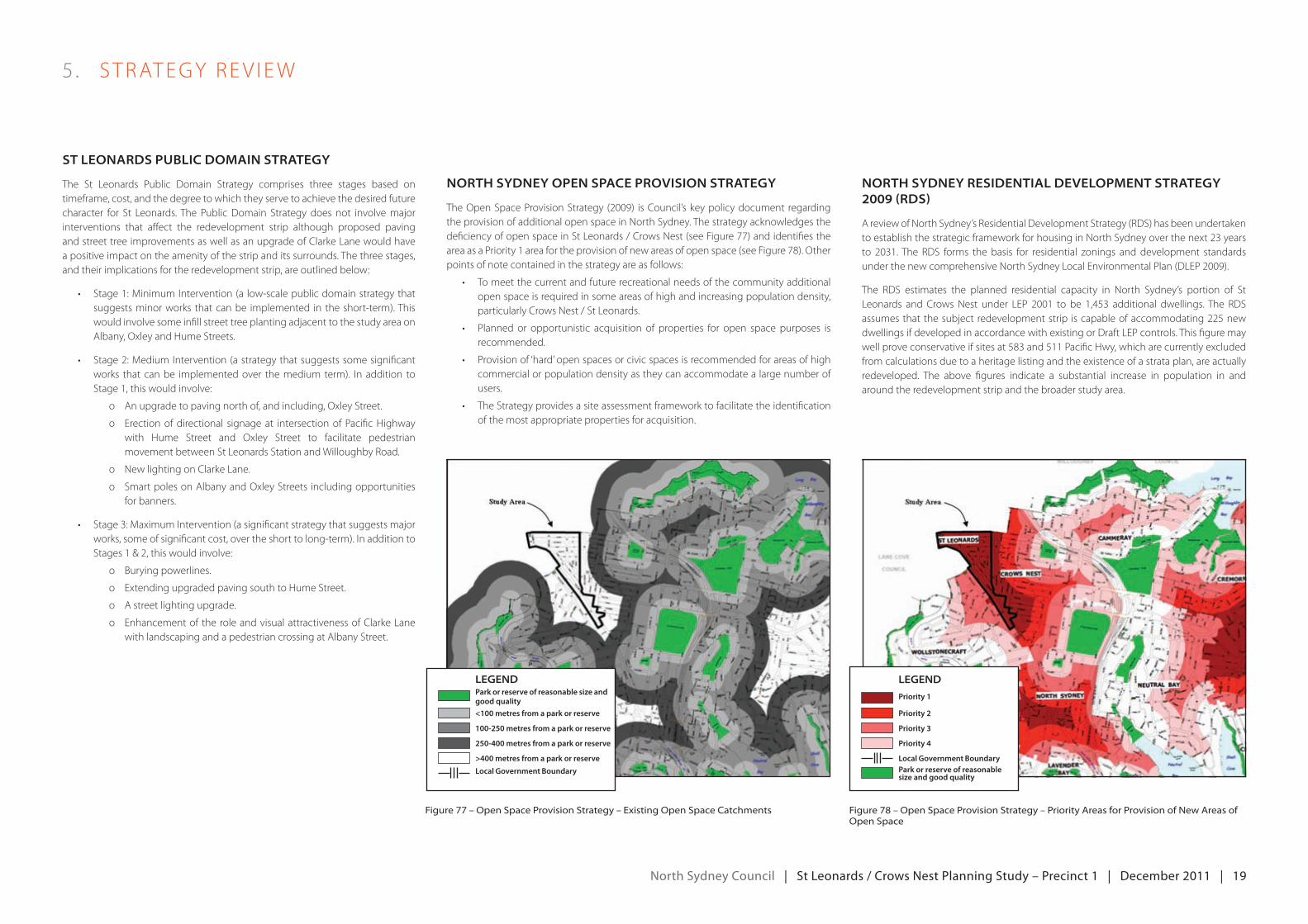
TheopenSpaceProvisionStrategy (2009) isCouncil’skeypolicydocument regardingthe provision of additional open space in North Sydney. The strategy acknowledges the deficiencyofopenspaceinStLeonards/CrowsNest(seeFigure77)andidentifiestheareaasaPriority1areafortheprovisionofnewareasofopenspace(seeFigure78).otherpoints of note contained in the strategy are as follows:
• Tomeetthecurrentandfuturerecreationalneedsofthecommunityadditionalopenspaceisrequiredinsomeareasofhighandincreasingpopulationdensity,particularly Crows Nest / St Leonards.
• Planned or opportunistic acquisition of properties for open space purposes isrecommended.
• Provisionof‘hard’openspacesorcivicspacesisrecommendedforareasofhighcommercial or population density as they can accommodate a large number of users.
• TheStrategyprovidesasiteassessmentframeworktofacilitatetheidentificationofthemostappropriatepropertiesforacquisition.
north Sydney reSidentiAL deveLopment StrAtegy 2009 (rdS)
A review of North Sydney’s Residential Development Strategy (RDS) has been undertaken to establish the strategic framework for housing in North Sydney over the next 23 years to 2031.The rdS forms the basis for residential zonings and development standardsunderthenewcomprehensiveNorthSydneyLocalenvironmentalPlan(dLeP2009).
The RDS estimates the planned residential capacity in North Sydney’s portion of St Leonards and CrowsNest under LeP 2001 to be 1,453 additional dwellings.The rdSassumesthatthesubject redevelopmentstrip iscapableofaccommodating225newdwellings if developed in accordance with existing or Draft LeP controls. This figure may wellproveconservativeifsitesat583and511PacificHwy,whicharecurrentlyexcludedfrom calculations due to a heritage listing and the existence of a strata plan, are actually redeveloped. The above figures indicate a substantial increase in population in and around the redevelopment strip and the broader study area.
north Sydney council | St Leonards / crows nest planning Study – precinct 1 | december 2011 | 20
5 . STrATegyrev Iew
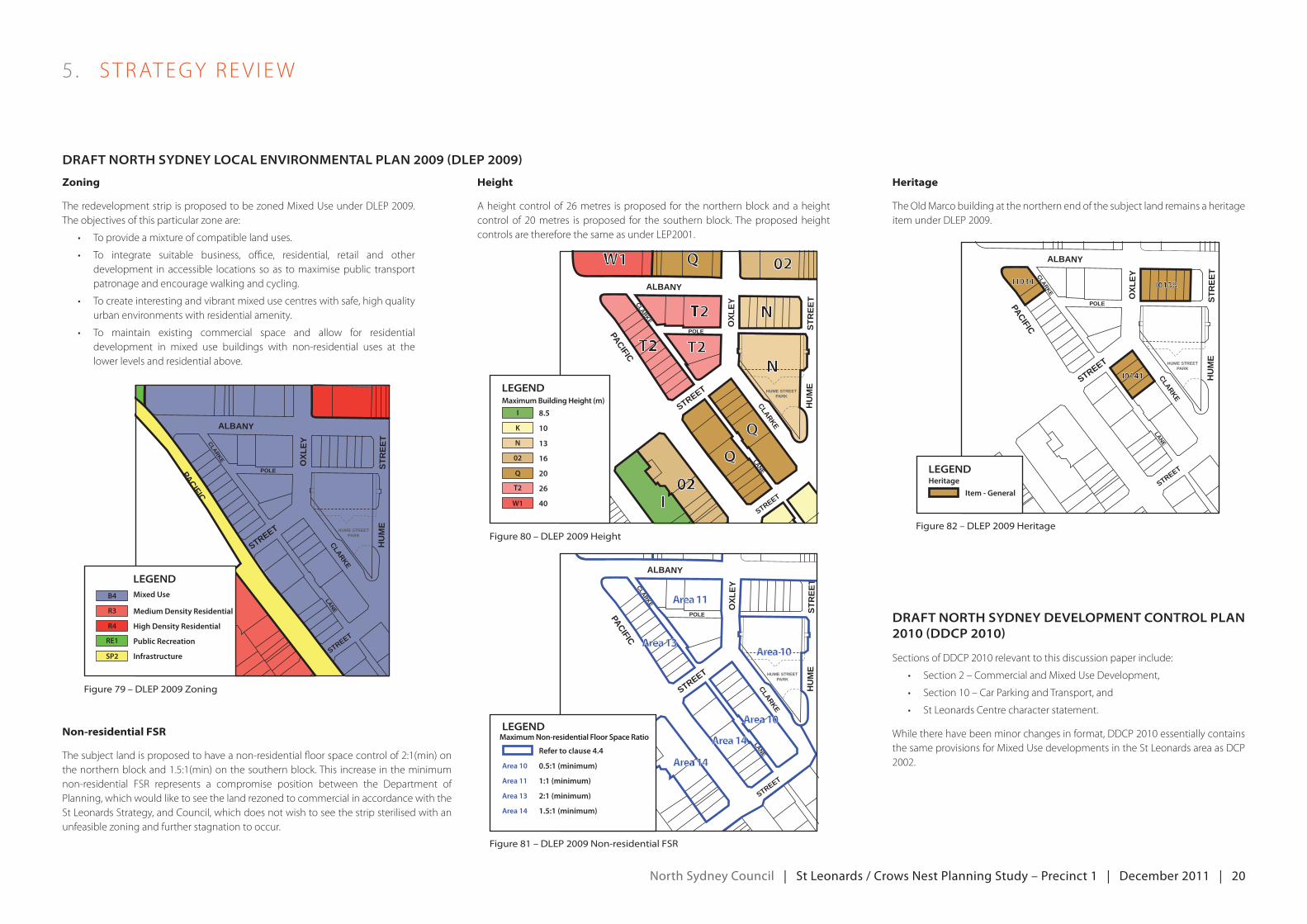
drAft north Sydney LocAL environmentAL pLAn 2009 (dLep 2009)
figure 80 – Dlep 2009 height
figure 81 – Dlep 2009 non-residential fsr
02QW1
T2 N
N
Q
Q
02I
T2T2
ALBANY
PACIFICCLARKE
POLE
LANECLARKE
OXL
EY
STREET
STREET
STR
EET
HU
ME
HUME STREETPARK
Heritage
TheoldmarcobuildingatthenorthernendofthesubjectlandremainsaheritageitemunderdLeP2009.
drAft north Sydney deveLopment controL pLAn 2010 (ddcp 2010)
SectionsofddCP2010relevanttothisdiscussionpaperinclude:
• Section2–Commercialandmixedusedevelopment,
• Section10–CarParkingandTransport,and
• StLeonardsCentrecharacterstatement.
whiletherehavebeenminorchangesinformat,ddCP2010essentiallycontainsthesameprovisionsformixedusedevelopmentsintheStLeonardsareaasdCP2002.
Zoning
TheredevelopmentstripisproposedtobezonedmixeduseunderdLeP2009.The objectives of this particular zone are:
• Toprovideamixtureofcompatiblelanduses.
• To integrate suitable business, office, residential, retail and otherdevelopment in accessible locations so as to maximise public transport patronage and encourage walking and cycling.
• Tocreateinterestingandvibrantmixedusecentreswithsafe,highqualityurban environments with residential amenity.
• To maintain existing commercial space and allow for residentialdevelopment in mixed use buildings with non-residential uses at the lower levels and residential above.
ALBANY
PACIFICCLARKE
POLE
LANECLARKE
OXL
EY
STREET
STREET
STR
EET
HU
ME
HUME STREETPARK
ALBANY
PACIFICCLARKE
POLE
LANECLARKE
OXL
EY
STREET
STREET
STR
EET
HU
ME
HUME STREETPARK
I1034
I0141
I0138
figure 79 – Dlep 2009 Zoning
figure 82 – Dlep 2009 heritage
ALBANY
PACIFICCLARKE
POLE
LANECLARKE
OXL
EY
STREET
STREET
STR
EET
HU
ME
HUME STREETPARK
Area 14
Area 14
Area 10
Area 10
Area 11
Area 13
Height
A height control of 26 metres is proposed for the northern block and a height controlof 20metres isproposed for the southernblock.TheproposedheightcontrolsarethereforethesameasunderLeP2001.
Non-residential FSR
The subject land is proposed to have a non-residential floor space control of 2:1(min) on thenorthernblockand1.5:1(min)onthesouthernblock.Thisincreaseintheminimumnon-residential FSR represents a compromise position between the Department of Planning, which would like to see the land rezoned to commercial in accordance with the St Leonards Strategy, and Council, which does not wish to see the strip sterilised with an unfeasible zoning and further stagnation to occur.
Legend
High Density Residential
Medium Density Residential
Mixed Use
Public Recreation
Infrastructure
B4
R3
R4
RE1
SP2
Legend
Item - General
Heritage
Legend
20
16
13
10
8.5
Maximum Building Height (m)
26
40
N
K
I
02
Q
T2
W1
1:1 (minimum)Area 11
0.5:1 (minimum)Area 10
Refer to clause 4.4
2:1 (minimum)Area 13
1.5:1 (minimum)Area 14
LegendMaximum Non-residential Floor Space Ratio
north Sydney council | St Leonards / crows nest planning Study – precinct 1 | december 2011 | 21
opportunitieS
Ifappropriately redeveloped, thesubjectstripalongthePacificHighwaycouldhelp achieve the following aims of the broader planning study:
• IncreasedinvestmentinStLeonardsanddecreasedcommercialvacancyrates, with particular focus on the rejuvenation of the Pacific Highway between St Leonards train station and the intersection of Pacific Highway and Willoughby Road.
• Improvedconnectivity,particularlybetweenStLeonards/PacificHighwayand Willoughby Road.
• ImprovedurbandesignandstreetlevelamenityparticularlyinStLeonardsand along the Pacific Highway.
• ImprovedbuildingdesignandresidentialamenityinStLeonards.
Opportunities can be broadly grouped into three categories:
• Improvedpedestriancirculationandamenity
• Newopenspace
• developmentfeasibilitythroughincreasedbuildingheight
improved pedestrian circulation and amenity
Redevelopment presents an ideal opportunity to improve pedestrian flow and amenity.
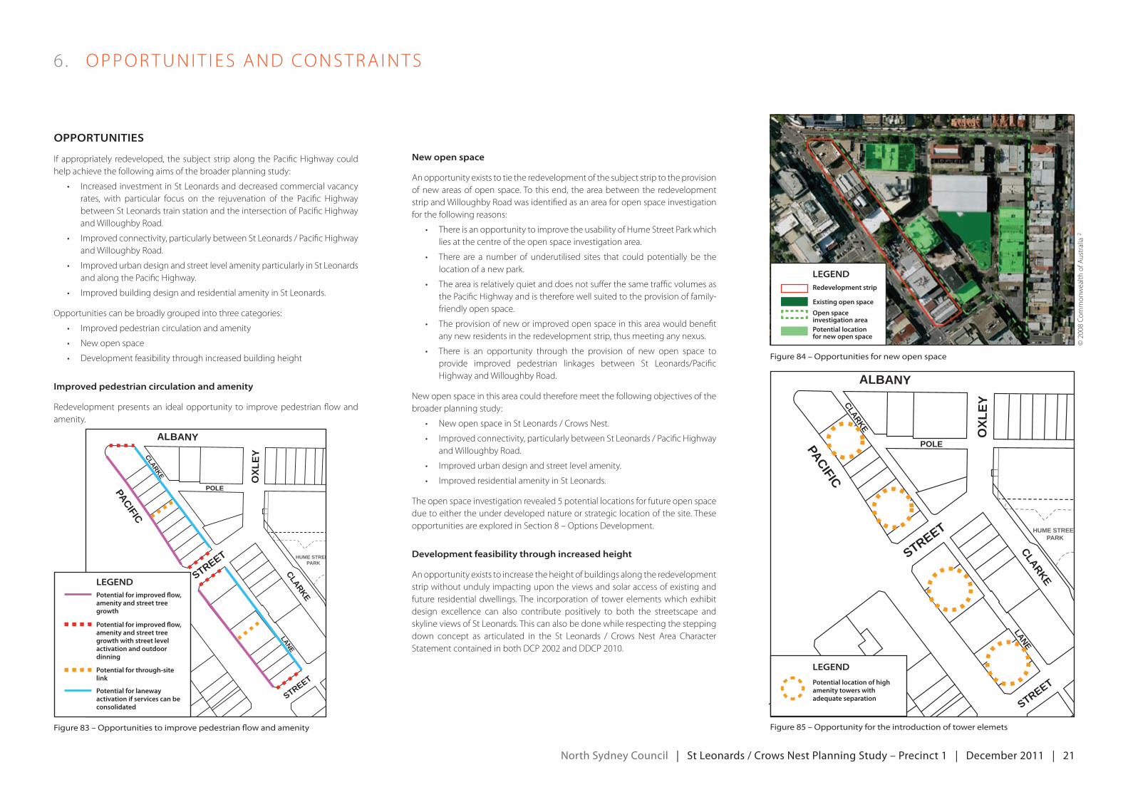
new open space
An opportunity exists to tie the redevelopment of the subject strip to the provision of new areas of open space. To this end, the area between the redevelopment strip and Willoughby Road was identified as an area for open space investigation for the following reasons:
• ThereisanopportunitytoimprovetheusabilityofHumeStreetParkwhichlies at the centre of the open space investigation area.
• There are a number of underutilised sites that couldpotentially be thelocation of a new park.
• Theareaisrelativelyquietanddoesnotsufferthesametrafficvolumesasthe Pacific Highway and is therefore well suited to the provision of family-friendly open space.
• Theprovisionofneworimprovedopenspaceinthisareawouldbenefitany new residents in the redevelopment strip, thus meeting any nexus.
• There is an opportunity through the provision of new open space toprovide improved pedestrian linkages between St Leonards/Pacific Highway and Willoughby Road.
New open space in this area could therefore meet the following objectives of the broader planning study:
• NewopenspaceinStLeonards/CrowsNest.
• Improvedconnectivity,particularlybetweenStLeonards/PacificHighwayand Willoughby Road.
• Improvedurbandesignandstreetlevelamenity.
• ImprovedresidentialamenityinStLeonards.
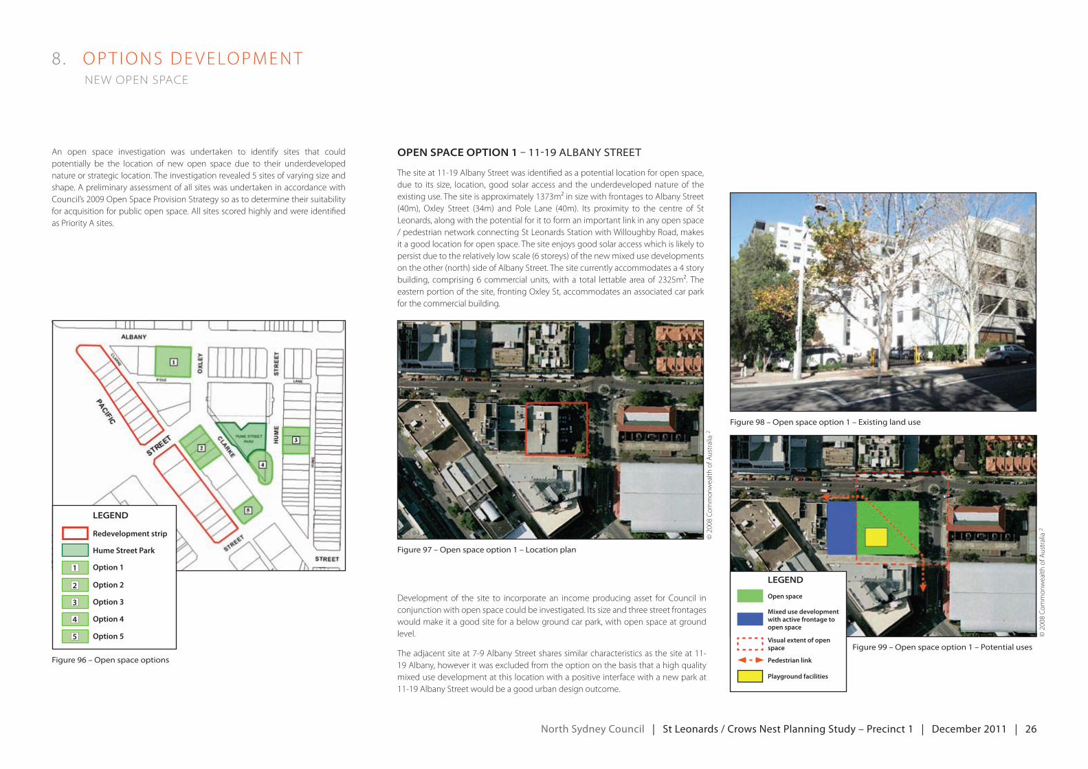
Theopenspaceinvestigationrevealed5potentiallocationsforfutureopenspacedue to either the under developed nature or strategic location of the site. These opportunitiesareexploredinSection8–optionsdevelopment.
development feasibility through increased height
An opportunity exists to increase the height of buildings along the redevelopment strip without unduly impacting upon the views and solar access of existing and future residential dwellings. The incorporation of tower elements which exhibit design excellence can also contribute positively to both the streetscape and skyline views of St Leonards. This can also be done while respecting the stepping down concept as articulated in the St Leonards / Crows Nest Area Character StatementcontainedinbothdCP2002andddCP2010.
6 . oPPorTuNIT I eS ANdCoNSTrA INTS
ALBANY
PACIFICCLARKE
POLE
LANECLARKE
OXL
EY
STREET
STREET
STR
EET
HU
ME
HUME STREETPARK
figure 83 – opportunities to improve pedestrian flow and amenity
figure 84 – opportunities for new open space
figure 85 – opportunity for the introduction of tower elemets
ALBANY
PACIFICCLARKE
POLE
LANECLARKE
OXL
EY
STREET
STREET
STR
EET
HU
ME
HUME STREETPARK
LegendPotential for improved flow, amenity and street tree growth
Potential for improved flow, amenity and street tree growth with street level activation and outdoor dinning
Potential for through-site link
Potential for laneway activation if services can be consolidated
Legend
Potential location of high amenity towers with adequate separation
Legend
Open space investigation area
Existing open space
Redevelopment strip
Potential location for new open space
©2008Co
mmon
wealth
ofA
ustralia
2
north Sydney council | St Leonards / crows nest planning Study – precinct 1 | december 2011 | 22
6 . oPPorTuNIT I eS ANdCoNSTrA INTS
conStrAintS
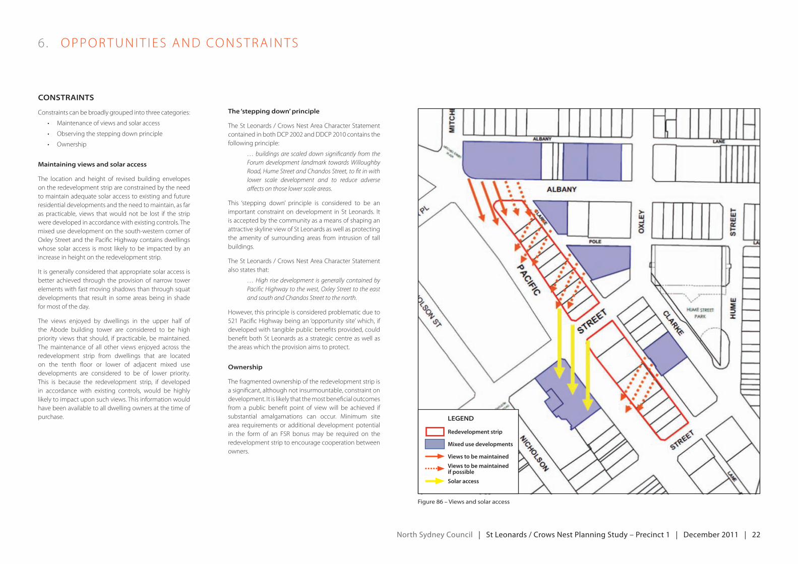
Constraints can be broadly grouped into three categories:
• maintenanceofviewsandsolaraccess
• observingthesteppingdownprinciple
• ownership
maintaining views and solar access
The location and height of revised building envelopes on the redevelopment strip are constrained by the need tomaintainadequatesolaraccesstoexistingandfutureresidential developments and the need to maintain, as far as practicable, views that would not be lost if the strip were developed in accordance with existing controls. The mixed use development on the south-western corner of Oxley Street and the Pacific Highway contains dwellings whose solar access is most likely to be impacted by an increase in height on the redevelopment strip.
Itisgenerallyconsideredthatappropriatesolaraccessisbetter achieved through the provision of narrow tower elementswithfastmovingshadowsthanthroughsquatdevelopments that result in some areas being in shade for most of the day.
The views enjoyed by dwellings in the upper half of the Abode building tower are considered to be high priority views that should, if practicable, be maintained. The maintenance of all other views enjoyed across the redevelopment strip from dwellings that are located on the tenth floor or lower of adjacent mixed use developments are considered to be of lower priority. This is because the redevelopment strip, if developed in accordance with existing controls, would be highly likely to impact upon such views. This information would have been available to all dwelling owners at the time of purchase.
figure 86 – views and solar access
the ‘stepping down’ principle
The St Leonards / Crows Nest Area Character Statement containedinbothdCP2002andddCP2010containsthefollowing principle:
… buildings are scaled down significantly from the Forum development landmark towards Willoughby Road, Hume Street and Chandos Street, to fit in with lower scale development and to reduce adverse affects on those lower scale areas.
This ‘stepping down’ principle is considered to be an importantconstraintondevelopment inStLeonards. Itis accepted by the community as a means of shaping an attractive skyline view of St Leonards as well as protecting the amenity of surrounding areas from intrusion of tall buildings.
The St Leonards / Crows Nest Area Character Statement also states that:
… High rise development is generally contained by Pacific Highway to the west, Oxley Street to the east and south and Chandos Street to the north.
However, this principle is considered problematic due to 521PacificHighwaybeingan‘opportunitysite’which, ifdeveloped with tangible public benefits provided, could benefit both St Leonards as a strategic centre as well as the areas which the provision aims to protect.
ownership
The fragmented ownership of the redevelopment strip is a significant, although not insurmountable, constraint on development.Itislikelythatthemostbeneficialoutcomesfrom a public benefit point of view will be achieved if substantial amalgamations can occur. minimum sitearea requirements or additional development potentialin the form of an FSr bonus may be required on theredevelopment strip to encourage cooperation between owners.
Legend
Redevelopment strip
Mixed use developments
Views to be maintained
Views to be maintained if possible
Solar access
north Sydney council | St Leonards / crows nest planning Study – precinct 1 | december 2011 | 23
principle 1 – Development opportunities and public benefit
The driving principle behind the broader St Leonards / Crows Nest Planning Study, of which this smaller study is a component, is that any additional development opportunities are matched by public benefits of commensurate value. These benefits must be in addition to what would normally be required by a newdevelopment, such as design excellence. The two main public benefits that would meet the aims of the planning study, and which are desperately needed in St Leonards, are:
• An expanded public domain where appropriate, and a qualitativeimprovement in the public domain on, and immediately surrounding, the redevelopmentstrip;and
• New areas of significant open space in appropriate locations in closeproximity to the redevelopment strip.
These ‘tradeoffs’ could be built into mandated planning controls or could occur via bonus mechanisms whereby development opportunities beyond those available under existing controls can only be pursued if predetermined public benefits are provided.
principle 2 – shifting existing Development Capacity
Relocating existing development potential allows some sites to become new open space while others increase their development potential.
principle 3 – pedestrian Circulation
Strengthening pedestrian routes, particularly those between St Leonards and Willoughby Road, is a priority of the study.
principle 4 – activities and uses
Redevelopment should allow for ground level activation with uses appropriate to the location and consistent with the strategic vision for the area.
7 . Pr INC IPLeS ANdPr Ior IT I eS
principLeS
figure 88 – pedestrian circulation
figure 87 – relocating existing development potential to free up land for open space
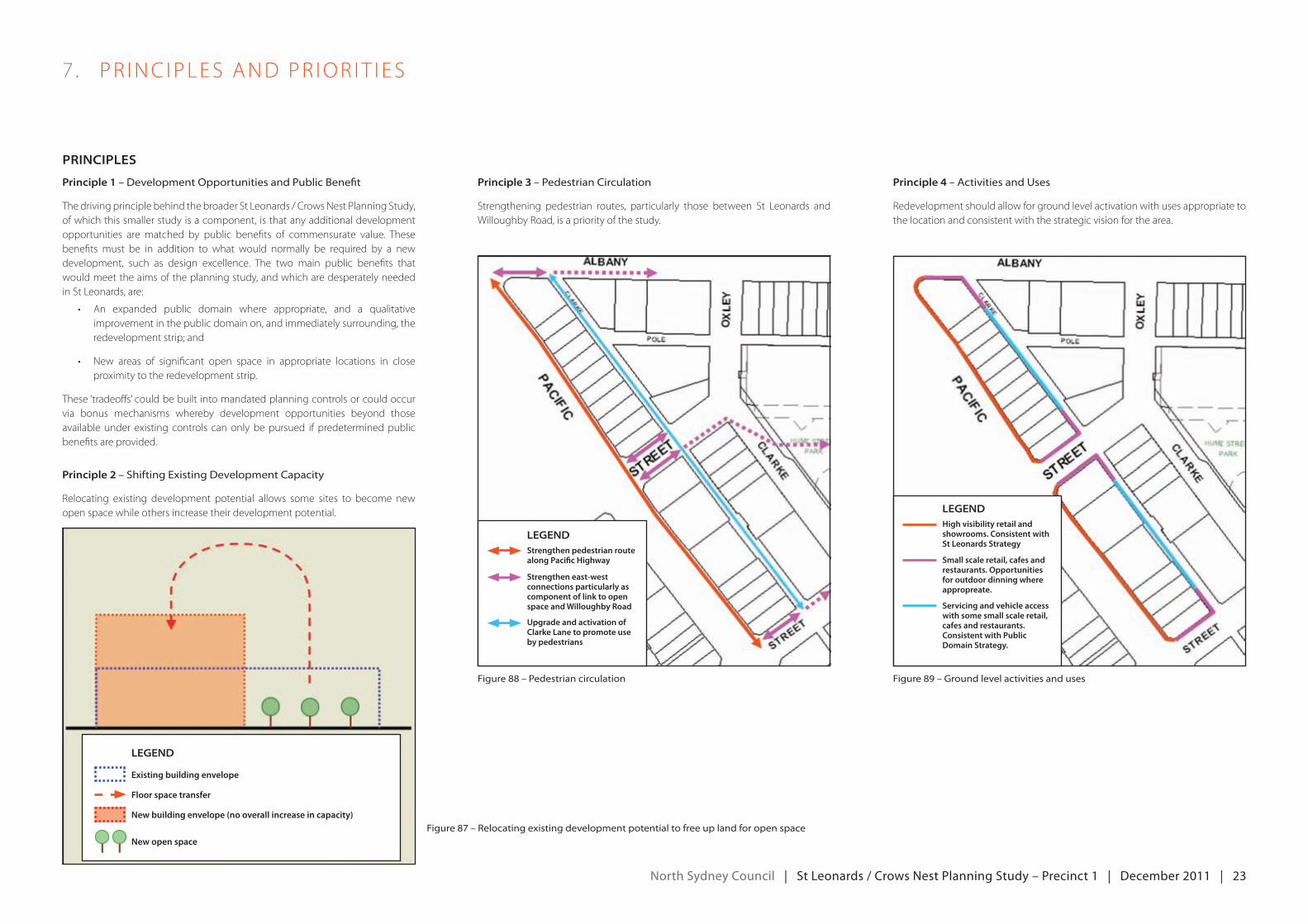
figure 89 – ground level activities and uses
Legend
New building envelope (no overall increase in capacity)
Existing building envelope
Floor space transfer
New open space
LegendStrengthen pedestrian route along Pacific Highway
Strengthen east-west connections particularly as component of link to open space and Willoughby Road
Upgrade and activation of Clarke Lane to promote use by pedestrians
LegendHigh visibility retail and showrooms. Consistent with St Leonards Strategy
Small scale retail, cafes and restaurants. Opportunities for outdoor dinning where appropreate.
Servicing and vehicle access with some small scale retail, cafes and restaurants. Consistent with Public Domain Strategy.
north Sydney council | St Leonards / crows nest planning Study – precinct 1 | december 2011 | 24
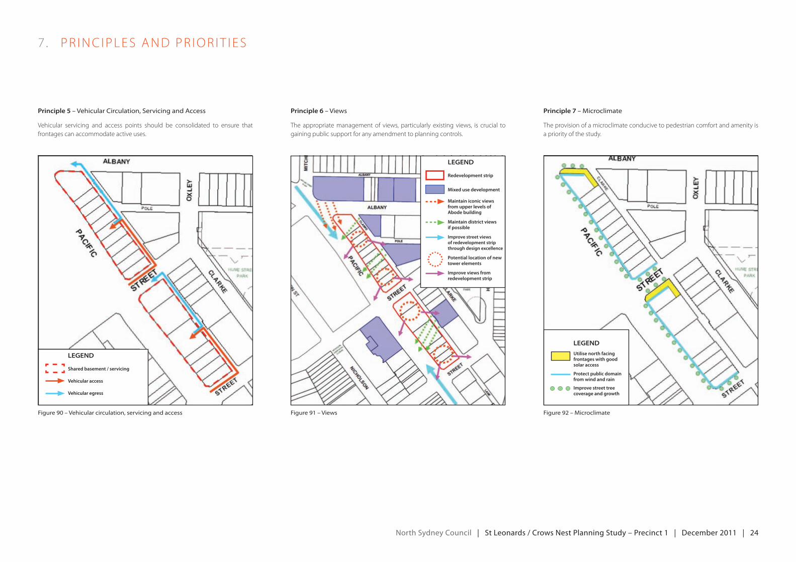
principle 5 – vehicular Circulation, servicing and access
vehicular servicing and access points should be consolidated to ensure thatfrontages can accommodate active uses.
principle 6 – views
The appropriate management of views, particularly existing views, is crucial to gaining public support for any amendment to planning controls.
principle 7 – microclimate
The provision of a microclimate conducive to pedestrian comfort and amenity is a priority of the study.
7 . Pr INC IPLeS ANdPr Ior IT I eS
figure 91 – viewsfigure 90 – vehicular circulation, servicing and access figure 92 – microclimate
Legend
Vehicular egress
Shared basement / servicing
Vehicular access
Legend
Maintain iconic views from upper levels of Abode building
Maintain district views if possible
Improve street views of redevelopment strip through design excellence
Potential location of new tower elements
Improve views from redevelopment strip
Redevelopment strip
Mixed use development
Legend
Utilise north facing frontages with good solar access
Protect public domain from wind and rain
Improve street tree coverage and growth
north Sydney council | St Leonards / crows nest planning Study – precinct 1 | december 2011 | 25
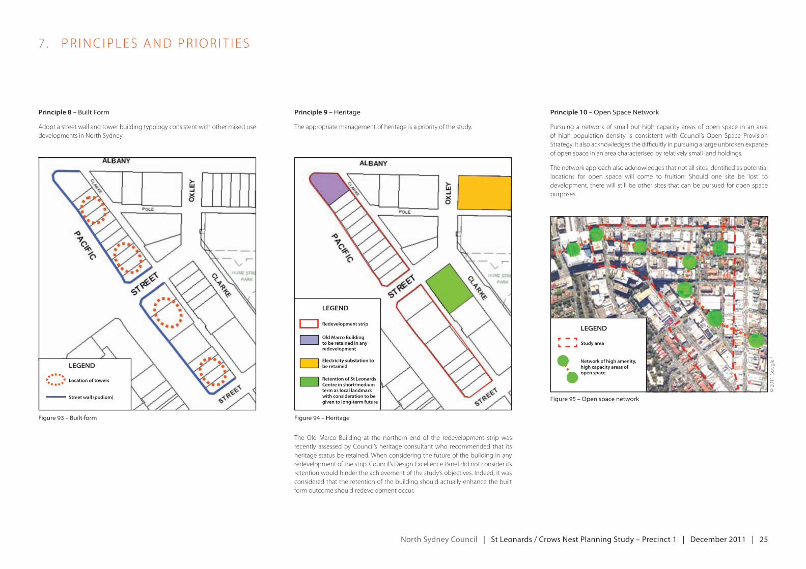
principle 8 – built form
Adopt a street wall and tower building typology consistent with other mixed use developments in North Sydney.
principle 9 – heritage
The appropriate management of heritage is a priority of the study.
The oldmarco building at the northern end of the redevelopment strip wasrecently assessed by Council’s heritage consultant who recommended that its heritage status be retained. When considering the future of the building in any redevelopment of the strip, Council’s Design excellence Panel did not consider its retentionwouldhindertheachievementofthestudy’sobjectives.Indeed,itwasconsidered that the retention of the building should actually enhance the built form outcome should redevelopment occur.
principle 10 – open space network
Pursuing a network of small but high capacity areas of open space in an area of high population density is consistent with Council’s Open Space Provision Strategy.Italsoacknowledgesthedifficultlyinpursuingalargeunbrokenexpanseof open space in an area characterised by relatively small land holdings.
The network approach also acknowledges that not all sites identified as potential locations for open space will come to fruition. Should one site be ‘lost’ to development, there will still be other sites that can be pursued for open space purposes.
7 . Pr INC IPLeS ANdPr Ior IT I eS
figure 94 – heritagefigure 93 – built form
figure 95 – open space network
Legend
Location of towers
Street wall (podium)
Legend
Study area
Network of high amenity, high capacity areas of open space
Legend
Redevelopment strip
Old Marco Building to be retained in any redevelopment
Electricity substation to be retained
Retention of St Leonards Centre in short/medium term as local landmark with consideration to be given to long-term future
©2011goo
gle
1
north Sydney council | St Leonards / crows nest planning Study – precinct 1 | december 2011 | 26
8 . oPT IoNSdeveLoPmeNT new open space
An open space investigation was undertaken to identify sites that could potentially be the location of new open space due to their underdeveloped natureorstrategiclocation.Theinvestigationrevealed5sitesofvaryingsizeandshape. A preliminary assessment of all sites was undertaken in accordance with Council’s2009openSpaceProvisionStrategysoastodeterminetheirsuitabilityforacquisitionforpublicopenspace.Allsitesscoredhighlyandwereidentifiedas Priority A sites.
open SpAce option 1 – 11-19 albany street
The site at 11-19 Albany Street was identified as a potential location for open space, due to its size, location, good solar access and the underdeveloped nature of the existinguse.Thesiteisapproximately1373m²insizewithfrontagestoAlbanyStreet(40m), oxley Street (34m) and Pole Lane (40m). Its proximity to the centre of StLeonards, along with the potential for it to form an important link in any open space / pedestrian network connecting St Leonards Station with Willoughby Road, makes it a good location for open space. The site enjoys good solar access which is likely to persist due to the relatively low scale (6 storeys) of the new mixed use developments ontheother(north)sideofAlbanyStreet.Thesitecurrentlyaccommodatesa4storybuilding, comprising6 commercialunits,witha total lettableareaof2325m².Theeastern portion of the site, fronting Oxley St, accommodates an associated car park for the commercial building.
figure 96 – open space options
figure 97 – open space option 1 – location plan
figure 98 – open space option 1 – existing land use
figure 99 – open space option 1 – potential uses
Development of the site to incorporate an income producing asset for Council in conjunctionwithopenspacecouldbeinvestigated.Itssizeandthreestreetfrontageswould make it a good site for a below ground car park, with open space at ground level.
Theadjacentsiteat7-9AlbanyStreetsharessimilarcharacteristicsasthesiteat11-19Albany,howeveritwasexcludedfromtheoptiononthebasisthatahighqualitymixed use development at this location with a positive interface with a new park at 11-19 Albany Street would be a good urban design outcome.
Legend
Redevelopment strip
Hume Street Park
Option 1
Option 2
Option 3
Option 4
Option 5
1
2
3
4
5
©2008Co
mmon
wealth
ofA
ustralia
2
©2008Co
mmon
wealth
ofA
ustralia
2
Legend
Open space
Mixed use development with active frontage to open space
Visual extent of open space
Pedestrian link
Playground facilities
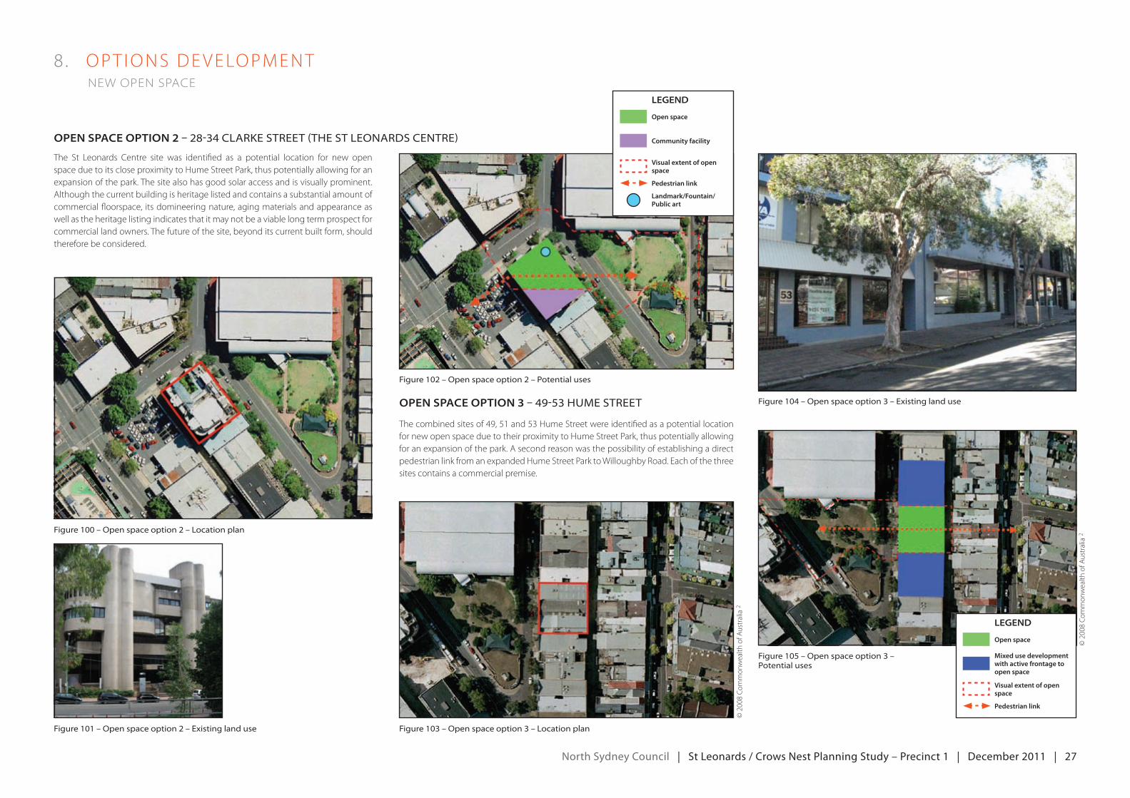
north Sydney council | St Leonards / crows nest planning Study – precinct 1 | december 2011 | 27
8 . oPT IoNSdeveLoPmeNT new open space
The St Leonards Centre site was identified as a potential location for new open space due to its close proximity to Hume Street Park, thus potentially allowing for an expansion of the park. The site also has good solar access and is visually prominent. Although the current building is heritage listed and contains a substantial amount of commercial floorspace, its domineering nature, aging materials and appearance as well as the heritage listing indicates that it may not be a viable long term prospect for commercial land owners. The future of the site, beyond its current built form, should therefore be considered.
figure 100 – open space option 2 – location plan
figure 102 – open space option 2 – potential uses
figure 103 – open space option 3 – location plan
figure 104 – open space option 3 – existing land use
figure 101 – open space option 2 – existing land use
figure 105 – open space option 3 – potential uses
open SpAce option 3 – 49-53 hume street
Thecombinedsitesof49,51and53HumeStreetwereidentifiedasapotentiallocationfor new open space due to their proximity to Hume Street Park, thus potentially allowing for an expansion of the park. A second reason was the possibility of establishing a direct pedestrian link from an expanded Hume Street Park to Willoughby Road. each of the three sites contains a commercial premise.
open SpAce option 2 – 28-34 Clarke street (the st leonarDs Centre)
©2008Co
mmon
wealth
ofA
ustralia
2
©2008Co
mmon
wealth
ofA
ustralia
2
Legend
Open space
Community facility
Visual extent of open space
Pedestrian link
Landmark/Fountain/Public art
Legend
Open space
Mixed use development with active frontage to open space
Visual extent of open space
Pedestrian link
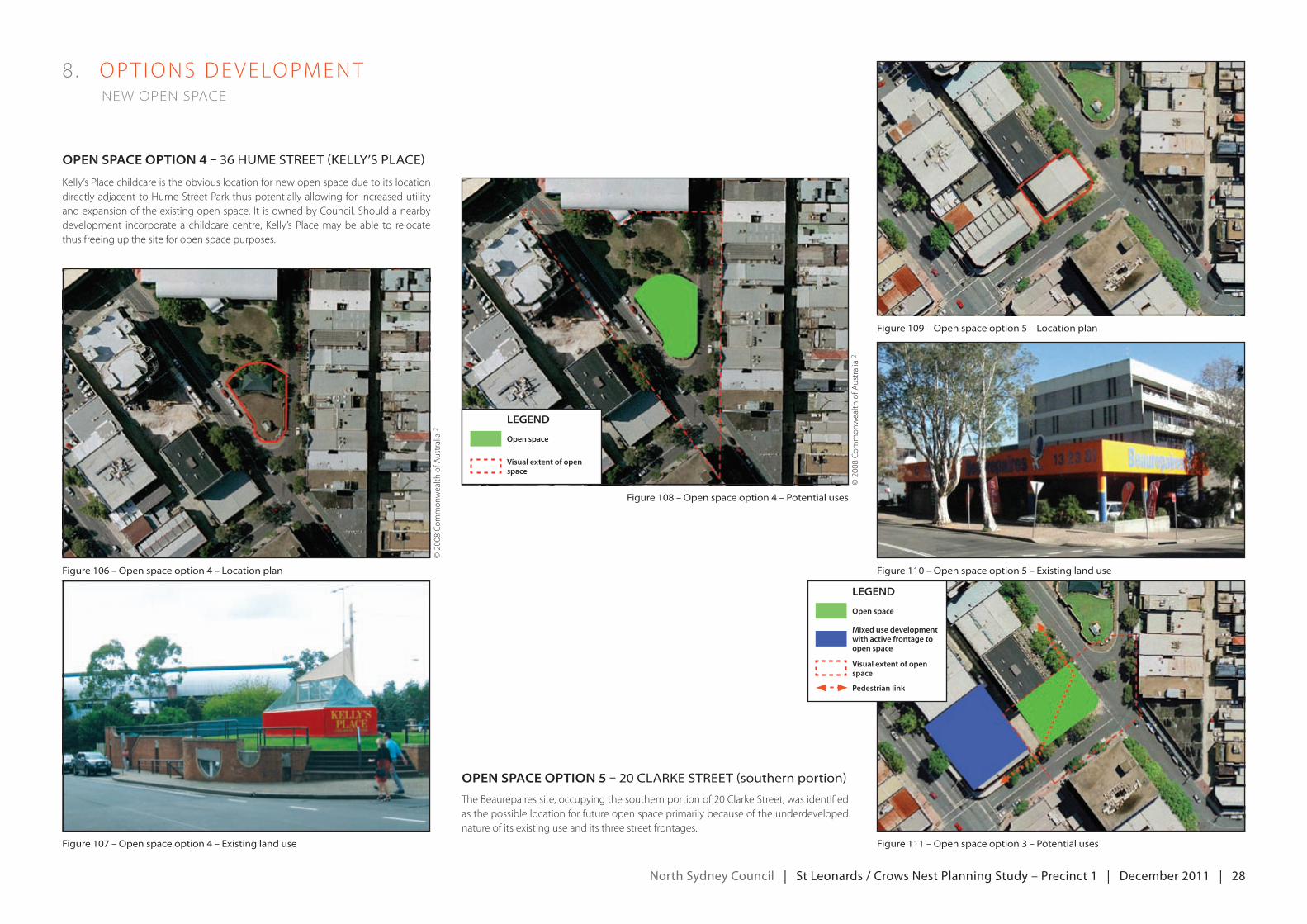
north Sydney council | St Leonards / crows nest planning Study – precinct 1 | december 2011 | 28
8 . oPT IoNSdeveLoPmeNT new open space
Kelly’s Place childcare is the obvious location for new open space due to its location directly adjacent to Hume Street Park thus potentially allowing for increased utility andexpansionoftheexistingopenspace.ItisownedbyCouncil.Shouldanearbydevelopment incorporate a childcare centre, Kelly’s Place may be able to relocate thus freeing up the site for open space purposes.
figure 106 – open space option 4 – location plan
figure 108 – open space option 4 – potential uses
figure 109 – open space option 5 – location plan
figure 110 – open space option 5 – existing land use
figure 107 – open space option 4 – existing land use figure 111 – open space option 3 – potential uses
open SpAce option 5 – 20 Clarke street (southern portion)
Thebeaurepairessite,occupyingthesouthernportionof20ClarkeStreet,wasidentifiedas the possible location for future open space primarily because of the underdeveloped nature of its existing use and its three street frontages.
open SpAce option 4 – 36 hume street (kelly’s plaCe)
©2008Co
mmon
wealth
ofA
ustralia
2
©2008Co
mmon
wealth
ofA
ustralia
2
Legend
Open space
Visual extent of open space
Legend
Open space
Mixed use development with active frontage to open space
Visual extent of open space
Pedestrian link
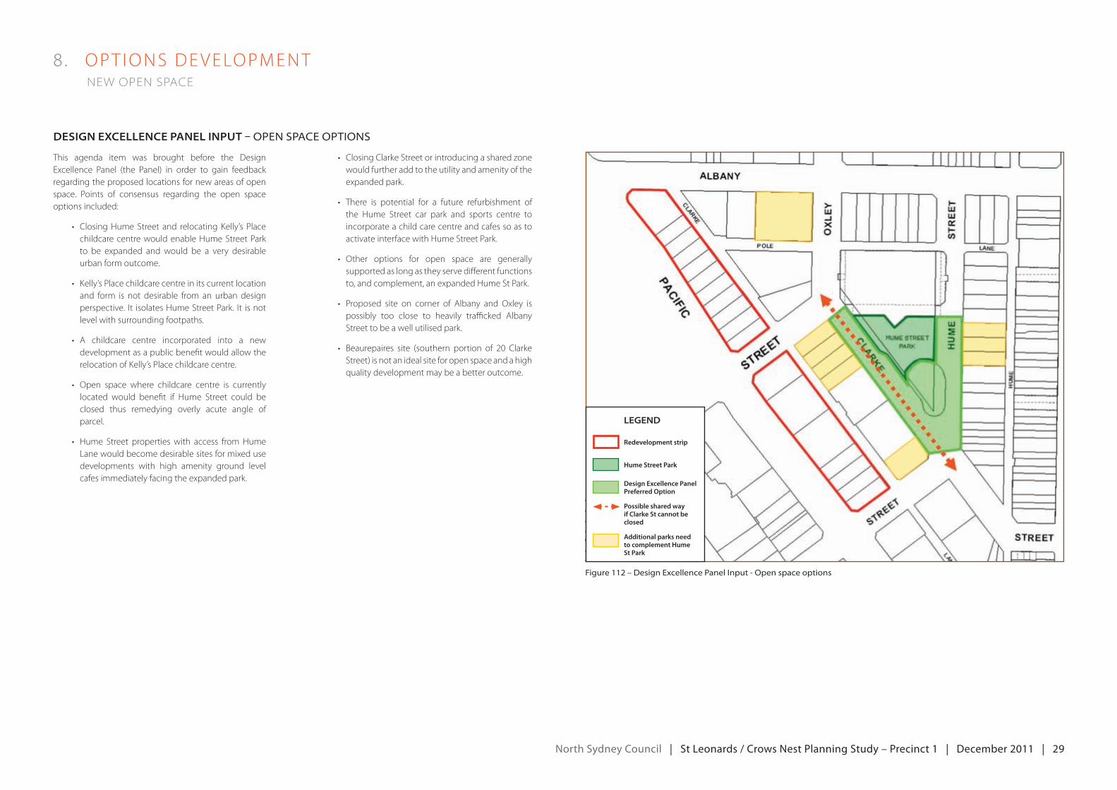
north Sydney council | St Leonards / crows nest planning Study – precinct 1 | december 2011 | 29
deSign exceLLence pAneL input – open spaCe options
This agenda item was brought before the Design excellence Panel (the Panel) in order to gain feedback regarding the proposed locations for new areas of open space. Points of consensus regarding the open space options included:
• ClosingHumeStreet and relocatingkelly’s Placechildcare centre would enable Hume Street Park to be expanded and would be a very desirable urban form outcome.
• kelly’sPlacechildcarecentreinitscurrentlocationand form is not desirable from an urban design perspective. It isolatesHumeStreetPark. It isnotlevel with surrounding footpaths.
• A childcare centre incorporated into a newdevelopment as a public benefit would allow the relocation of Kelly’s Place childcare centre.
• open space where childcare centre is currentlylocated would benefit if Hume Street could be closed thus remedying overly acute angle of parcel.
• Hume Street propertieswith access fromHumeLane would become desirable sites for mixed use developments with high amenity ground level cafes immediately facing the expanded park.
• ClosingClarkeStreetorintroducingasharedzonewould further add to the utility and amenity of the expanded park.
• There is potential for a future refurbishment ofthe Hume Street car park and sports centre to incorporate a child care centre and cafes so as to activate interface with Hume Street Park.
• other options for open space are generallysupported as long as they serve different functions to, and complement, an expanded Hume St Park.
• Proposed site on corner of Albany and oxley ispossibly too close to heavily trafficked Albany Street to be a well utilised park.
• beaurepaires site (southern portion of 20 ClarkeStreet) is not an ideal site for open space and a high qualitydevelopmentmaybeabetteroutcome.
8 . oPT IoNSdeveLoPmeNT new open space
Legend
Redevelopment strip
Hume Street Park
Design Excellence Panel Preferred Option
Possible shared way if Clarke St cannot be closed
Additional parks need to complement Hume St Park
figure 112 – Design excellence panel input - open space options
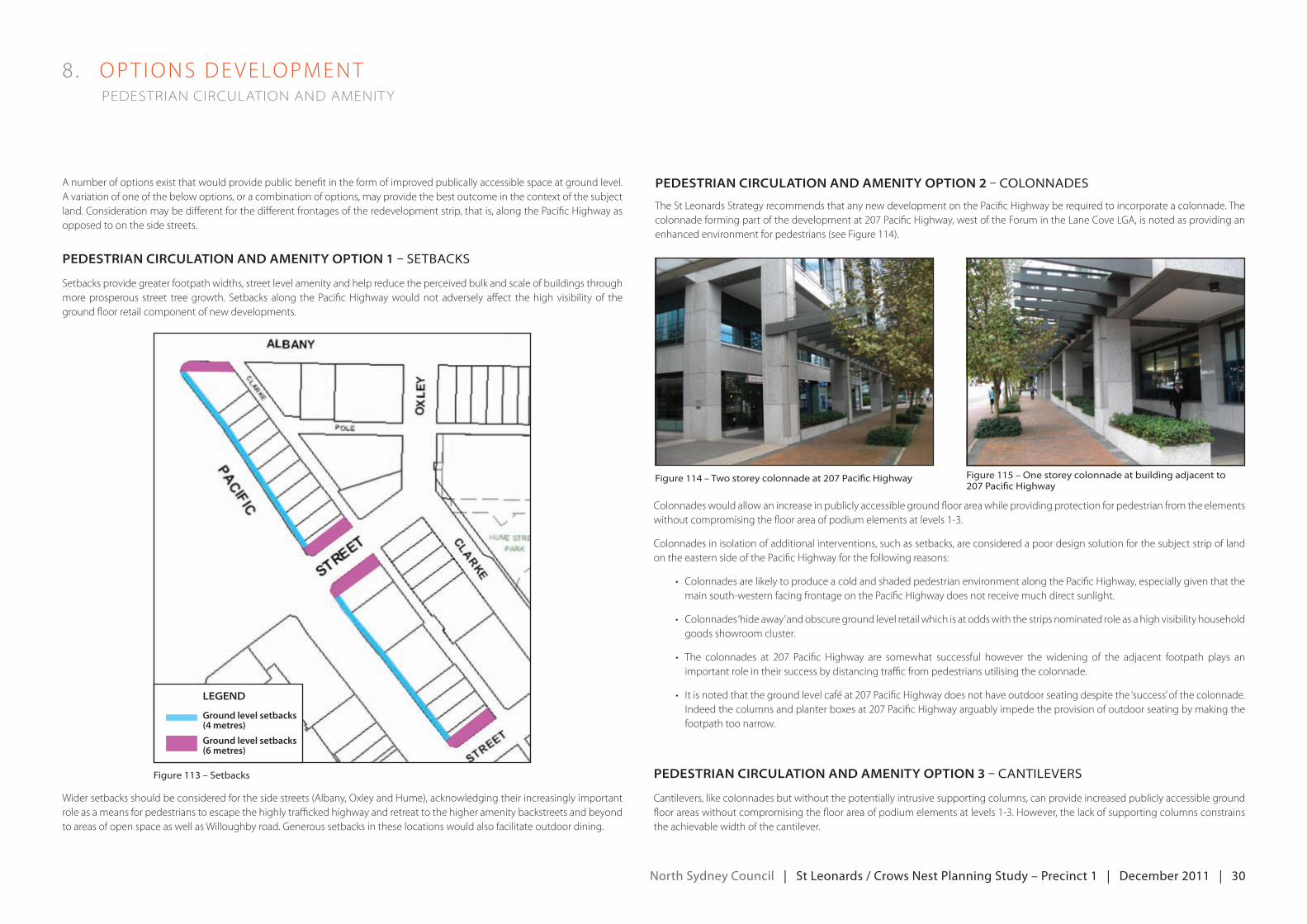
north Sydney council | St Leonards / crows nest planning Study – precinct 1 | december 2011 | 30
8 . oPT IoNSdeveLoPmeNT pedestrian circulation and amenity
pedeStriAn circuLAtion And Amenity option 2 – ColonnaDesA number of options exist that would provide public benefit in the form of improved publically accessible space at ground level. A variation of one of the below options, or a combination of options, may provide the best outcome in the context of the subject land. Consideration may be different for the different frontages of the redevelopment strip, that is, along the Pacific Highway as opposed to on the side streets.
pedeStriAn circuLAtion And Amenity option 1 – setbaCks
Setbacks provide greater footpath widths, street level amenity and help reduce the perceived bulk and scale of buildings through more prosperous street tree growth. Setbacks along the Pacific Highway would not adversely affect the high visibility of the ground floor retail component of new developments.
figure 114 – two storey colonnade at 207 pacific highway figure 115 – one storey colonnade at building adjacent to 207 pacific highway
figure 113 – setbacks
Wider setbacks should be considered for the side streets (Albany, Oxley and Hume), acknowledging their increasingly important role as a means for pedestrians to escape the highly trafficked highway and retreat to the higher amenity backstreets and beyond to areas of open space as well as Willoughby road. Generous setbacks in these locations would also facilitate outdoor dining.
Legend
Ground level setbacks (4 metres)
Ground level setbacks (6 metres)
TheStLeonardsStrategyrecommendsthatanynewdevelopmentonthePacificHighwayberequiredtoincorporateacolonnade.Thecolonnadeformingpartofthedevelopmentat207PacificHighway,westoftheForumintheLaneCoveLgA,isnotedasprovidinganenhancedenvironmentforpedestrians(seeFigure114).
Colonnades would allow an increase in publicly accessible ground floor area while providing protection for pedestrian from the elements without compromising the floor area of podium elements at levels 1-3.
Colonnades in isolation of additional interventions, such as setbacks, are considered a poor design solution for the subject strip of land on the eastern side of the Pacific Highway for the following reasons:
• ColonnadesarelikelytoproduceacoldandshadedpedestrianenvironmentalongthePacificHighway,especiallygiventhatthemain south-western facing frontage on the Pacific Highway does not receive much direct sunlight.
• Colonnades‘hideaway’andobscuregroundlevelretailwhichisatoddswiththestripsnominatedroleasahighvisibilityhouseholdgoods showroom cluster.
• The colonnades at 207 Pacific Highway are somewhat successful however the widening of the adjacent footpath plays animportant role in their success by distancing traffic from pedestrians utilising the colonnade.
• Itisnotedthatthegroundlevelcaféat207PacificHighwaydoesnothaveoutdoorseatingdespitethe‘success’ofthecolonnade.Indeedthecolumnsandplanterboxesat207PacificHighwayarguablyimpedetheprovisionofoutdoorseatingbymakingthefootpath too narrow.
pedeStriAn circuLAtion And Amenity option 3 – Cantilevers
Cantilevers, like colonnades but without the potentially intrusive supporting columns, can provide increased publicly accessible ground floor areas without compromising the floor area of podium elements at levels 1-3. However, the lack of supporting columns constrains the achievable width of the cantilever.
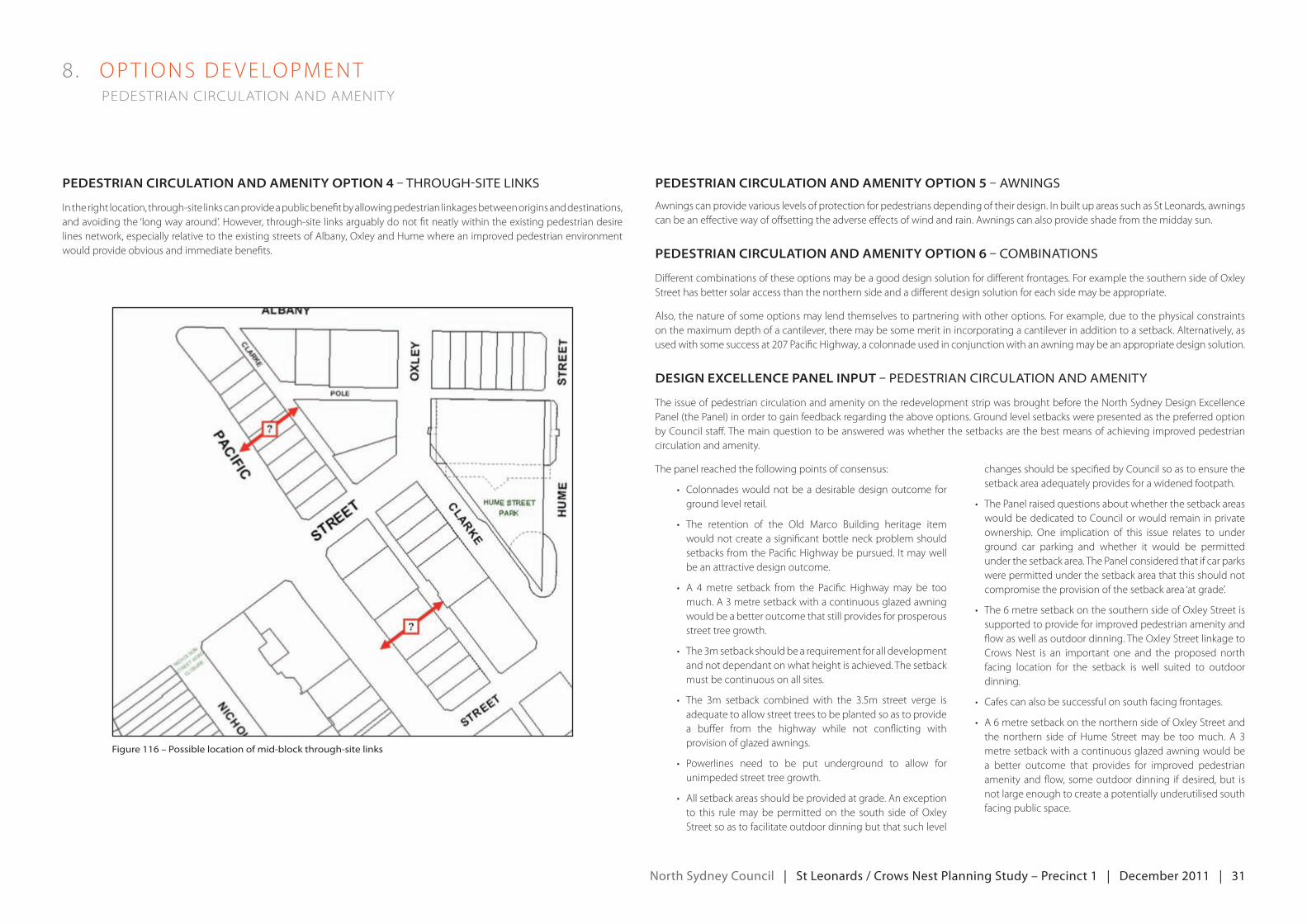
north Sydney council | St Leonards / crows nest planning Study – precinct 1 | december 2011 | 31
8 . oPT IoNSdeveLoPmeNT pedestrian circulation and amenity
pedeStriAn circuLAtion And Amenity option 5 – awningspedeStriAn circuLAtion And Amenity option 4 – through-site links
Intherightlocation,through-sitelinkscanprovideapublicbenefitbyallowingpedestrianlinkagesbetweenoriginsanddestinations,and avoiding the ‘long way around’. However, through-site links arguably do not fit neatly within the existing pedestrian desire lines network, especially relative to the existing streets of Albany, Oxley and Hume where an improved pedestrian environment would provide obvious and immediate benefits.
figure 116 – possible location of mid-block through-site links
Awningscanprovidevariouslevelsofprotectionforpedestriansdependingoftheirdesign.InbuiltupareassuchasStLeonards,awningscan be an effective way of offsetting the adverse effects of wind and rain. Awnings can also provide shade from the midday sun.
pedeStriAn circuLAtion And Amenity option 6 – Combinations
Different combinations of these options may be a good design solution for different frontages. For example the southern side of Oxley Street has better solar access than the northern side and a different design solution for each side may be appropriate.
Also, the nature of some options may lend themselves to partnering with other options. For example, due to the physical constraints on the maximum depth of a cantilever, there may be some merit in incorporating a cantilever in addition to a setback. Alternatively, as usedwithsomesuccessat207PacificHighway,acolonnadeusedinconjunctionwithanawningmaybeanappropriatedesignsolution.
deSign exceLLence pAneL input – peDestrian CirCulation anD amenity
The issue of pedestrian circulation and amenity on the redevelopment strip was brought before the North Sydney Design excellence Panel (the Panel) in order to gain feedback regarding the above options. Ground level setbacks were presented as the preferred option byCouncilstaff.Themainquestiontobeansweredwaswhetherthesetbacksarethebestmeansofachievingimprovedpedestriancirculation and amenity.
The panel reached the following points of consensus:
• Colonnadeswouldnotbeadesirabledesignoutcome forground level retail.
• The retention of the old marco building heritage itemwould not create a significant bottle neck problem should setbacksfromthePacificHighwaybepursued. Itmaywellbe an attractive design outcome.
• A 4metre setback from the Pacific Highwaymay be toomuch. A 3 metre setback with a continuous glazed awning would be a better outcome that still provides for prosperous street tree growth.
• The3msetbackshouldbearequirementforalldevelopmentand not dependant on what height is achieved. The setback must be continuous on all sites.
• The 3m setback combined with the 3.5m street verge isadequatetoallowstreettreestobeplantedsoastoprovidea buffer from the highway while not conflicting with provision of glazed awnings.
• Powerlines need to be put underground to allow forunimpeded street tree growth.
• Allsetbackareasshouldbeprovidedatgrade.Anexceptionto this rule may be permitted on the south side of Oxley Street so as to facilitate outdoor dinning but that such level
changes should be specified by Council so as to ensure the setbackareaadequatelyprovidesforawidenedfootpath.
• ThePanelraisedquestionsaboutwhetherthesetbackareaswould be dedicated to Council or would remain in private ownership. One implication of this issue relates to under ground car parking and whether it would be permitted under the setback area. The Panel considered that if car parks were permitted under the setback area that this should not compromise the provision of the setback area ‘at grade’.
• The6metresetbackonthesouthernsideofoxleyStreetissupported to provide for improved pedestrian amenity and flow as well as outdoor dinning. The Oxley Street linkage to Crows Nest is an important one and the proposed north facing location for the setback is well suited to outdoor dinning.
• Cafescanalsobesuccessfulonsouthfacingfrontages.
• A6metresetbackonthenorthernsideofoxleyStreetandthe northern side of Hume Street may be too much. A 3 metre setback with a continuous glazed awning would be a better outcome that provides for improved pedestrian amenity and flow, some outdoor dinning if desired, but is not large enough to create a potentially underutilised south facing public space.
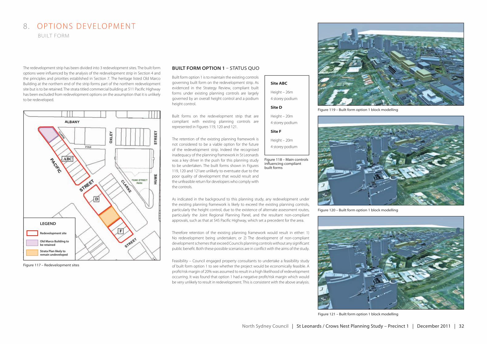
north Sydney council | St Leonards / crows nest planning Study – precinct 1 | december 2011 | 32
8 . oPT IoNSdeveLoPmeNT built form
The redevelopment strip has been divided into 3 redevelopment sites. The built form optionswereinfluencedbytheanalysisoftheredevelopmentstripinSection4andtheprinciplesandprioritiesestablishedinSection7.TheheritagelistedoldmarcoBuilding at the northern end of the strip forms part of the northern redevelopment sitebutistoberetained.Thestratatitledcommercialbuildingat511PacificHighwayhas been excluded from redevelopment options on the assumption that it is unlikely to be redeveloped.
BuiLt form option 1 – status Quo
Built form option 1 is to maintain the existing controls governing built form on the redevelopment strip. As evidenced in the Strategy Review, compliant built forms under existing planning controls are largely governed by an overall height control and a podium height control.
Built forms on the redevelopment strip that are compliant with existing planning controls are representedinFigures119,120and121.
The retention of the existing planning framework is not considered to be a viable option for the future of the redevelopment strip. Indeed the recognisedinadequacyoftheplanningframeworkinStLeonardswas a key driver in the push for this planning study to be undertaken. The built forms shown in Figures 119,120and121areunlikelytoeventuateduetothepoor quality of development thatwould result andthe unfeasible return for developers who comply with the controls.
As indicated in the background to this planning study, any redevelopment under the existing planning framework is likely to exceed the existing planning controls, particularly the height control, due to the existence of alternate assessment routes, particularly the joint regional Planning Panel, and the resultant non-compliantapprovals,suchasthatat545PacificHighway,whichsetaprecedentforthearea.
Therefore retention of the existing planning framework would result in either: 1) No redevelopment being undertaken; or 2) The development of non-compliantdevelopment schemes that exceed Councils planning controls without any significant public benefit. Both these possible scenarios are in conflict with the aims of the study.
Feasibility–Councilengagedpropertyconsultants toundertakea feasibilitystudyof built form option 1 to see whether the project would be economically feasible. A profit/riskmarginof20%wasassumedtoresultinahighlikelihoodofredevelopmentoccurring.Itwasfoundthatoption1hadanegativeprofit/riskmarginwhichwouldbe very unlikely to result in redevelopment. This is consistent with the above analysis.
Legend
Redevelopment site
Old Marco Building to be retained
Strata Plan likely to remain undeveloped
figure 117 – redevelopment sites
figure 118 – main controls influencing compliant built forms
Site ABC
Height–26m
4storeypodium
Site D
Height–20m
4storeypodium
Site F
Height–20m
4storeypodium
figure 119 – built form option 1 block modelling
figure 120 – built form option 1 block modelling
figure 121 – built form option 1 block modelling
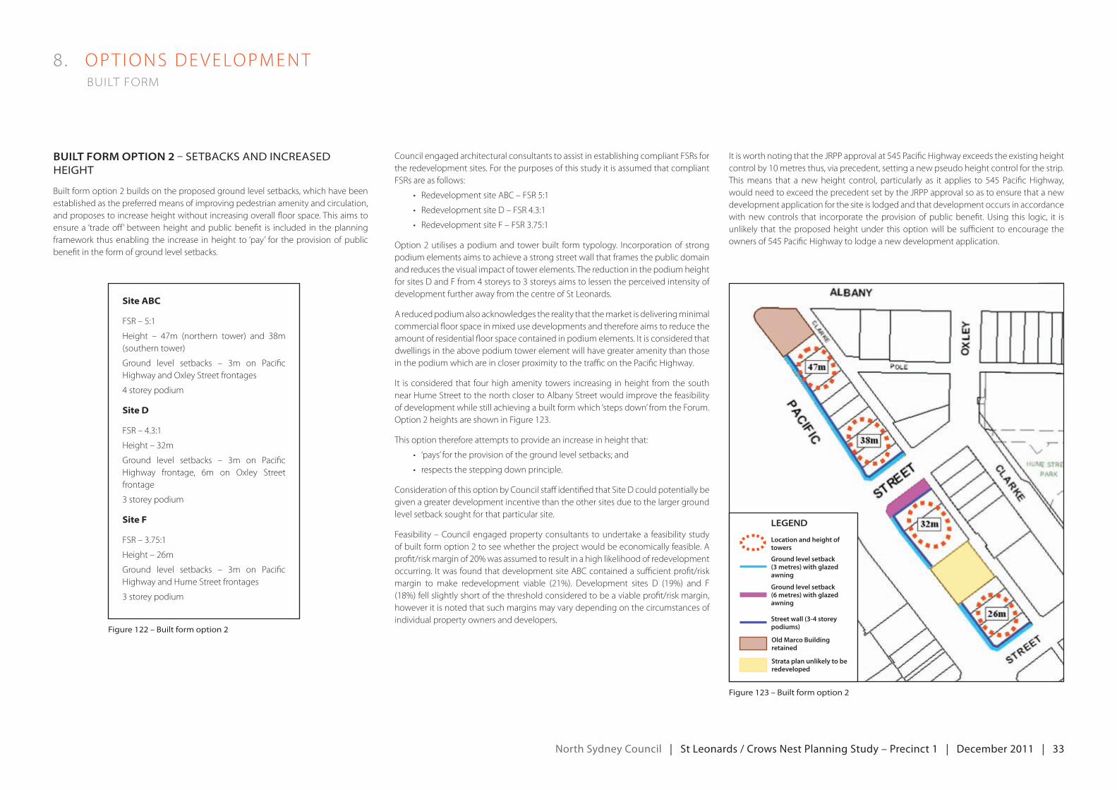
north Sydney council | St Leonards / crows nest planning Study – precinct 1 | december 2011 | 33
8 . oPT IoNSdeveLoPmeNT built form
BuiLt form option 2 – setbaCks anD inCreaseD height
Built form option 2 builds on the proposed ground level setbacks, which have been established as the preferred means of improving pedestrian amenity and circulation, and proposes to increase height without increasing overall floor space. This aims to ensure a ‘trade off’ between height and public benefit is included in the planning framework thus enabling the increase in height to ‘pay’ for the provision of public benefit in the form of ground level setbacks.
Council engaged architectural consultants to assist in establishing compliant FSRs for the redevelopment sites. For the purposes of this study it is assumed that compliant FSRs are as follows:
• redevelopmentsiteAbC–FSr5:1
• redevelopmentsited–FSr4.3:1
• redevelopmentsiteF–FSr3.75:1
option2utilisesapodiumandtowerbuilt formtypology. Incorporationofstrongpodium elements aims to achieve a strong street wall that frames the public domain and reduces the visual impact of tower elements. The reduction in the podium height forsitesdandFfrom4storeysto3storeysaimstolessentheperceivedintensityofdevelopment further away from the centre of St Leonards.
A reduced podium also acknowledges the reality that the market is delivering minimal commercial floor space in mixed use developments and therefore aims to reduce the amountofresidentialfloorspacecontainedinpodiumelements.Itisconsideredthatdwellings in the above podium tower element will have greater amenity than those in the podium which are in closer proximity to the traffic on the Pacific Highway.
It isconsideredthat fourhighamenitytowers increasing inheight fromthesouthnear Hume Street to the north closer to Albany Street would improve the feasibility of development while still achieving a built form which ‘steps down’ from the Forum. Option 2 heights are shown in Figure 123.
This option therefore attempts to provide an increase in height that:
• ‘pays’fortheprovisionofthegroundlevelsetbacks;and
• respectsthesteppingdownprinciple.
Consideration of this option by Council staff identified that Site D could potentially be given a greater development incentive than the other sites due to the larger ground level setback sought for that particular site.
Feasibility–Councilengagedpropertyconsultants toundertakea feasibilitystudyof built form option 2 to see whether the project would be economically feasible. A profit/riskmarginof20%wasassumedtoresultinahighlikelihoodofredevelopmentoccurring.ItwasfoundthatdevelopmentsiteAbCcontainedasufficientprofit/riskmargin to make redevelopment viable (21%). development sites d (19%) and F(18%)fellslightlyshortofthethresholdconsideredtobeaviableprofit/riskmargin,however it is noted that such margins may vary depending on the circumstances of individual property owners and developers.
figure 122 – built form option 2
Site ABC
FSr–5:1
Height – 47m (northern tower) and 38m(southern tower)
ground level setbacks – 3m on PacificHighway and Oxley Street frontages
4storeypodium
Site D
FSr–4.3:1
Height–32m
ground level setbacks – 3m on PacificHighway frontage, 6m on Oxley Street frontage
3 storey podium
Site F
FSr–3.75:1
Height–26m
ground level setbacks – 3m on PacificHighway and Hume Street frontages
3 storey podium
figure 123 – built form option 2
ItisworthnotingthatthejrPPapprovalat545PacificHighwayexceedstheexistingheightcontrolby10metresthus,viaprecedent,settinganewpseudoheightcontrolforthestrip.Thismeans that a newheight control, particularly as it applies to 545 PacificHighway,wouldneedtoexceedtheprecedentsetbythejrPPapprovalsoastoensurethatanewdevelopment application for the site is lodged and that development occurs in accordance with new controls that incorporate the provision of public benefit. Using this logic, it is unlikely that the proposed height under this option will be sufficient to encourage the ownersof545PacificHighwaytolodgeanewdevelopmentapplication.
Legend
Location and height of towers
Ground level setback (3 metres) with glazed awning
Street wall (3-4 storey podiums)
Ground level setback (6 metres) with glazed awning
Old Marco Building retained
Strata plan unlikely to be redeveloped
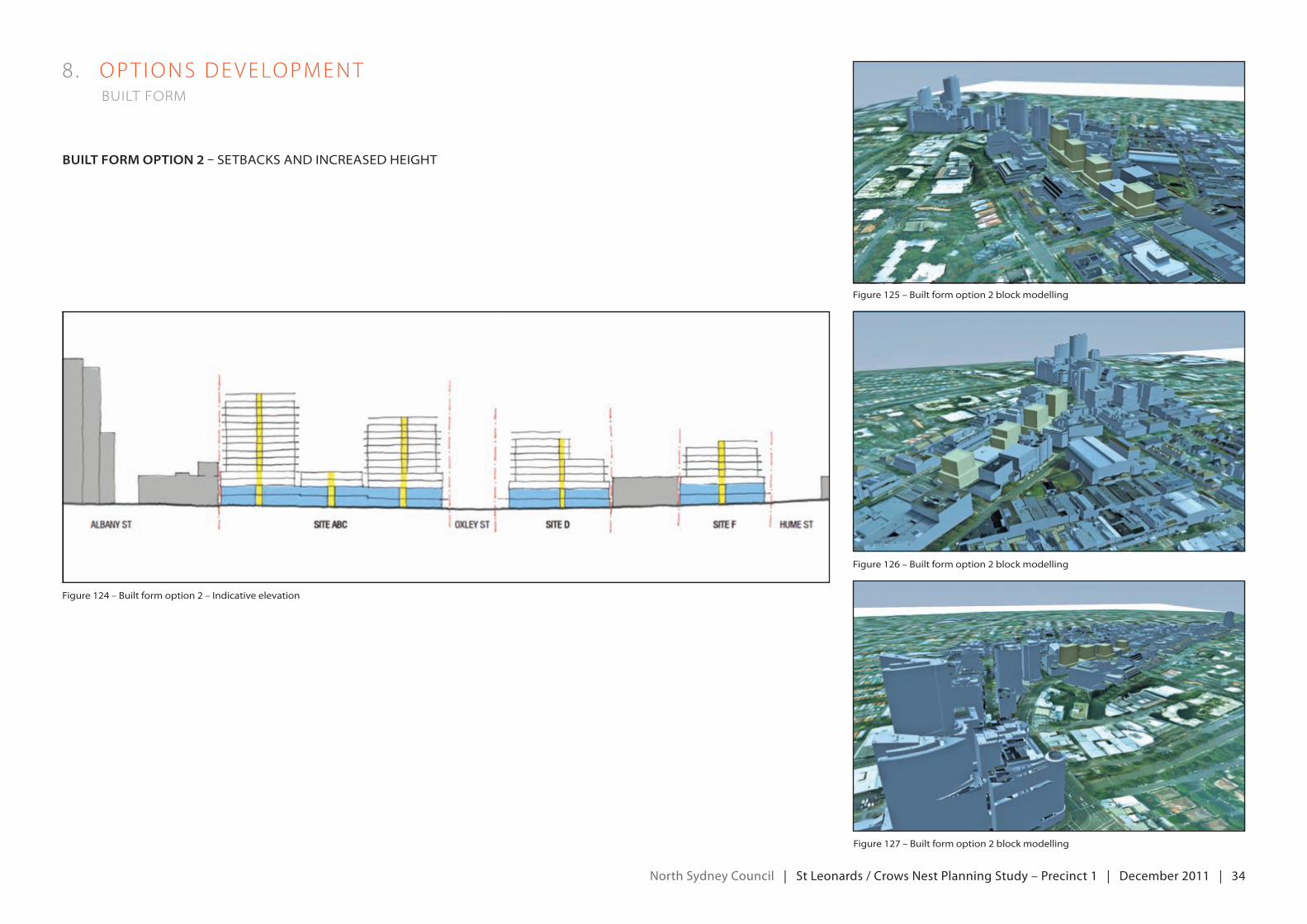
north Sydney council | St Leonards / crows nest planning Study – precinct 1 | december 2011 | 34
8 . oPT IoNSdeveLoPmeNT built form
BuiLt form option 2 – setbaCks anD inCreaseD height
figure 124 – built form option 2 – indicative elevation
figure 125 – built form option 2 block modelling
figure 126 – built form option 2 block modelling
figure 127 – built form option 2 block modelling
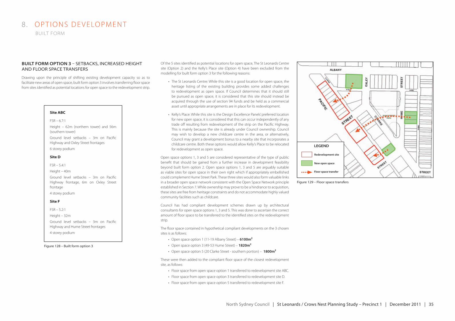
north Sydney council | St Leonards / crows nest planning Study – precinct 1 | december 2011 | 35
8 . oPT IoNSdeveLoPmeNT built form
BuiLt form option 3 – setbaCks, inCreaseD height anD floor spaCe transfers
Drawing upon the principle of shifting existing development capacity so as to facilitate new areas of open space, built form option 3 involves transferring floor space from sites identified as potential locations for open space to the redevelopment strip.
ofthe5sitesidentifiedaspotentiallocationsforopenspace,TheStLeonardsCentresite (option 2) and the kelly’s Place site (option 4) have been excluded from themodelling for built form option 3 for the following reasons:
• TheStLeonardsCentre:whilethissiteisagoodlocationforopenspace,theheritage listing of the existing building provides some added challenges to redevelopment as open space. If Council determines that it should stillbe pursued as open space, it is considered that this site should instead be acquiredthroughtheuseofsection94fundsandbeheldasacommercialasset until appropriate arrangements are in place for its redevelopment.
• kelly’sPlace:whilethissiteisthedesignexcellencePanels’preferredlocationfor new open space, it is considered that this can occur independently of any trade off resulting from redevelopment of the strip on the Pacific Highway. This is mainly because the site is already under Council ownership. Council may wish to develop a new childcare centre in the area, or alternatively, Council may grant a development bonus to a nearby site that incorporates a childcare centre. Both these options would allow Kelly’s Place to be relocated for redevelopment as open space.
openspaceoptions1,3and5areconsideredrepresentativeofthetypeofpublicbenefit that should be gained from a further increase in development feasibility beyondbuilt formoption2.open spaceoptions 1, 3 and5 are arguably suitableas viable sites for open space in their own right which if appropriately embellished could complement Hume Street Park. These three sites would also form valuable links in a broader open space network consistent with the Open Space Network principle establishedinSection7.whileownershipmayprovetobeahindrancetoacquisition,these sites are free from heritage constraints and do not accommodate highly valued community facilities such as childcare.
Council has had compliant development schemes drawn up by architectural consultantsforopenspaceoptions1,3and5.Thiswasdonetoascertainthecorrectamount of floor space to be transferred to the identified sites on the redevelopment strip.
The floor space contained in hypothetical compliant developments on the 3 chosen sites is as follows:
• openspaceoption1(11-19AlbanyStreet)–6100m²
• openspaceoption3(49-53HumeStreet)–1820m²
• openspaceoption5(20ClarkeStreet-southernportion)–1800m²
These were then added to the compliant floor space of the closest redevelopment site, as follows:
• Floorspacefromopenspaceoption1transferredtoredevelopmentsiteAbC.
• Floorspacefromopenspaceoption3transferredtoredevelopmentsited.
• Floorspacefromopenspaceoption5transferredtoredevelopmentsiteF.
figure 128 – built form option 3
Site ABC
FSr–6.7:1
Height – 62m (northern tower) and 56m(southern tower)
ground level setbacks – 3m on PacificHighway and Oxley Street frontages
6 storey podium
Site D
FSr–5.4:1
Height–40m
ground level setbacks – 3m on PacificHighway frontage, 6m on Oxley Street frontage
4storeypodium
Site F
FSr–5.2:1
Height–32m
ground level setbacks – 3m on PacificHighway and Hume Street frontages
4storeypodium
figure 129 – floor space transfers
Legend
Floor space transfer
Redevelopment site
New open space
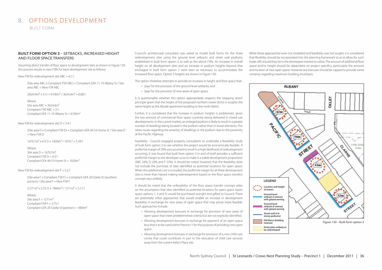
north Sydney council | St Leonards / crows nest planning Study – precinct 1 | december 2011 | 36
8 . oPT IoNSdeveLoPmeNT built form
BuiLt form option 3 – setbaCks, inCreaseD height anD floor spaCe transfers
Assuming direct transfer of floor space to development sites as shown in Figure 129, this process results in new FSRs for each development site as follows:
NewFSrforredevelopmentsiteAbC=6.7:1
(Site area ABC x Compliant FSR ABC) + Compliant GFA 11-19 Albany St / Site area ABC = New FSR ABC
(3624.4m²x5:1)+6100m²/3624.4m²=6.68:1
Where:SiteareaAbC=3624.4m²CompliantFSrAbC=5:1CompliantgFA11-19AlbanySt=6100m²
NewFSrforredevelopmentsited=5.4:1
(SiteareadxCompliantFSrd)+CompliantgFA49-53HumeSt/Sitearead= New FSR D
1670.7m²x4.3:1)+1820m²/1670.7=5.39:1
Where:Sitearead=1670.7m²CompliantFSrd=4.3:1CompliantgFA49-53HumeSt=1820m²
NewFSrforredevelopmentsiteF=5.2:1
(SiteareaFxCompliantFSrF)+CompliantgFA20ClarkeSt(southernportion) / Site area F = New FSR F
(1271m²x3.75:1)+1800m²/1271m²=5.17:1
Where:SiteareaF=1271m²CompliantFSrF=3.75:1CompliantgFA20ClarkeSt(portion)=1800m²
Council’s architectural consultant was asked to model built forms for the three redevelopment sites using the ground level setbacks and street wall podiums established in built form option 2 as well as the above FSRs. An increase in overall height on all development sites and an increase in podium heights beyond that envisaged in built form option 2 were seen as necessary to accommodate the increasedfloorspace.option3heightsareshowninFigure130.
This option therefore attempts to provide an increase in height and floor space that:
• ‘pays’fortheprovisionofthegroundlevelsetbacks;and
• ‘pays’fortheprovisionofnewareasofopenspace.
It is questionable whether this option appropriately respects the‘stepping down’principle given that the height of the proposed northern tower (62m) is roughly the sameheightastheAbodeapartmentbuildingtothenorth(60m).
Further, it is considered that the increase in podium heights is problematic given the low amount of commercial floor space currently being delivered in mixed use developments.Inthecurrentmarket,anenlargedpodiumislikelytoresultinagreaternumber of dwellings being located in the podium rather than in tower elements. This raises issues regarding the amenity of dwellings in the podium due to the proximity of the Pacific Highway.
Feasibility - Council engaged property consultants to undertake a feasibility study of built form option 3 to see whether the project would be economically feasible. A profit/riskmarginof20%wasassumedtoresultinahighlikelihoodofredevelopmentoccurring.Itwasfoundthatbuiltfromoption3inandofitselfprovidesasufficientprofit/risk margin to the developer so as to make it a viable development proposition (AbC24%,d20%andF22%).Itshouldbenoted,however,thatthefeasibilitydoesnot include the purchase of sites identified as potential locations for open space. When this additional cost is included, the profit/risk margin for all three development sites is more than halved making redevelopment based on the floor space transfers concept very unlikely.
It shouldbenoted that theunfeasibility of the floor space transfer concept relieson the assumption that sites identified as potential locations for open space (open spaceoptions1,3and5)wouldbepurchasedoutrightandgiftedtoCouncil.Thereare potentially other approaches that would enable an increase in development feasibility in exchange for new areas of open space that may prove more feasible. Such approaches include:
• Allowing development bonuses in exchange for provision of new areas ofopen space that meet predetermined criteria but are not explicitly identified.
• Allowingdevelopmentbonusesinexchangeforpaymentofanopenspacelevy that is to be used within Precinct 1 for the purpose of providing new open space.
• Allowingdevelopmentbonusesinexchangeforprovisionofanewchildcarecentre that could contribute in part to the relocation of child care services away from the current Kelly’s Place site.
figure 130 – built form option 3
While these approached were not modelled and feasibility was not sought, it is considered that flexibility should be incorporated into the planning framework so as to allow for such trade-offs should they be in the developers interest to utilise. The amount of additional floor space and/or height should be dependent on project specifics, particularly the amount and location of new open space. However any bonuses should be capped to provide some certainty regarding maximum building envelopes.
Legend
Old Marco Building retained
Strata plan unlikely to be redeveloped
Location and height of towers
Ground level setback (3 metres) with glazed awning
Ground level setback (6 metres) with glazed awning
Street wall (4-6 storey podiums)
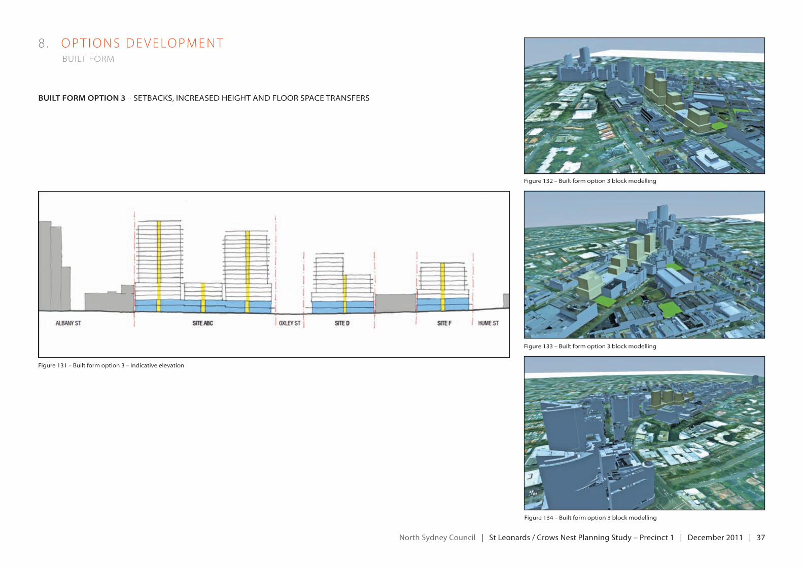
north Sydney council | St Leonards / crows nest planning Study – precinct 1 | december 2011 | 37
8 . oPT IoNSdeveLoPmeNT built form
BuiLt form option 3 – setbaCks, inCreaseD height anD floor spaCe transfers
figure 131 – built form option 3 – indicative elevation
figure 132 – built form option 3 block modelling
figure 133 – built form option 3 block modelling
figure 134 – built form option 3 block modelling
north Sydney council | St Leonards / crows nest planning Study – precinct 1 | december 2011 | 38
deSign exceLLence pAneL input – built form
Built form option 3 was brought before the Design excellence Panel (the Panel) to obtain feedback on the following:
• Apodiumandtowertypology
• Increasedheights
• NewFSrsbasedontransferoffloorspacefromthreeopenspacelocationstothreeredevelopmentsites
Comments regarding built form along the highway:
• Thepanelissupportiveofrequiringpublicbenefittobegainedfromincreasesindevelopmentfeasibility(e.g.allowingdevelopment bonuses on redevelopment sites in exchange for new open space being provided off site).
• Astrongpodiumat3-5storeyswillmeanthatheightoftowerelementsislessapparent.
• designoflowerlevelsofbuildingsshouldbethesameregardlessofFSr.AnyFSrbonusshouldonlyresultinhighertowerelements.
• bonusescouldbetiedtominimumsitearearequirementssoastoencourageamalgamation.
• Council couldconsideraprohibitionabovebaseFSrandheightunless satisfactoryarrangementsare inplace for theprovision of new open space.
• Non-activefrontagestohighwaycouldbeconsideredforresidentialportionofpodiumsasadesignresponsetonoisepollution from highway.
8 . oPT IoNSdeveLoPmeNT built form
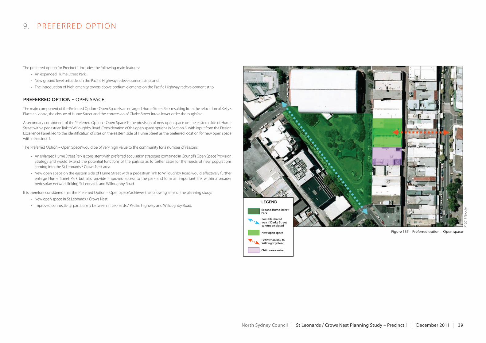
north Sydney council | St Leonards / crows nest planning Study – precinct 1 | december 2011 | 39
The preferred option for Precinct 1 includes the following main features:
• AnexpandedHumeStreetPark;
• NewgroundlevelsetbacksonthePacificHighwayredevelopmentstrip;and
• TheintroductionofhighamenitytowersabovepodiumelementsonthePacificHighwayredevelopmentstrip
preferred option – open spaCe
The main component of the Preferred Option - Open Space is an enlarged Hume Street Park resulting from the relocation of Kelly’s Place childcare, the closure of Hume Street and the conversion of Clarke Street into a lower order thoroughfare.
A secondary component of the ‘Preferred Option - Open Space’ is the provision of new open space on the eastern side of Hume Street with a pedestrian link to Willoughby Road. Consideration of the open space options in Section 8, with input from the Design excellence Panel, led to the identification of sites on the eastern side of Hume Street as the preferred location for new open space within Precinct 1.
The‘Preferredoption–openSpace’wouldbeofveryhighvaluetothecommunityforanumberofreasons:
• AnenlargedHumeStreetParkisconsistentwithpreferredacquisitionstrategiescontainedinCouncil’sopenSpaceProvisionStrategy and would extend the potential functions of the park so as to better cater for the needs of new populations coming into the St Leonards / Crows Nest area.
• NewopenspaceontheeasternsideofHumeStreetwithapedestrianlinktowilloughbyroadwouldeffectivelyfurtherenlarge Hume Street Park but also provide improved access to the park and form an important link within a broader pedestrian network linking St Leonards and Willoughby Road.
Itisthereforeconsideredthatthe‘Preferredoption–openSpace’achievesthefollowingaimsoftheplanningstudy:
• NewopenspaceinStLeonards/CrowsNest.
• Improvedconnectivity,particularlybetweenStLeonards/PacificHighwayandwilloughbyroad.
9 . PreFerredoPT IoN
figure 135 – preferred option – open space
Legend
Child care centre
Expand Hume Street Park
Possible shared way if Clarke Street cannot be closed
New open space
Pedestrian link to Willoughby Road
©2011goo
gle
1
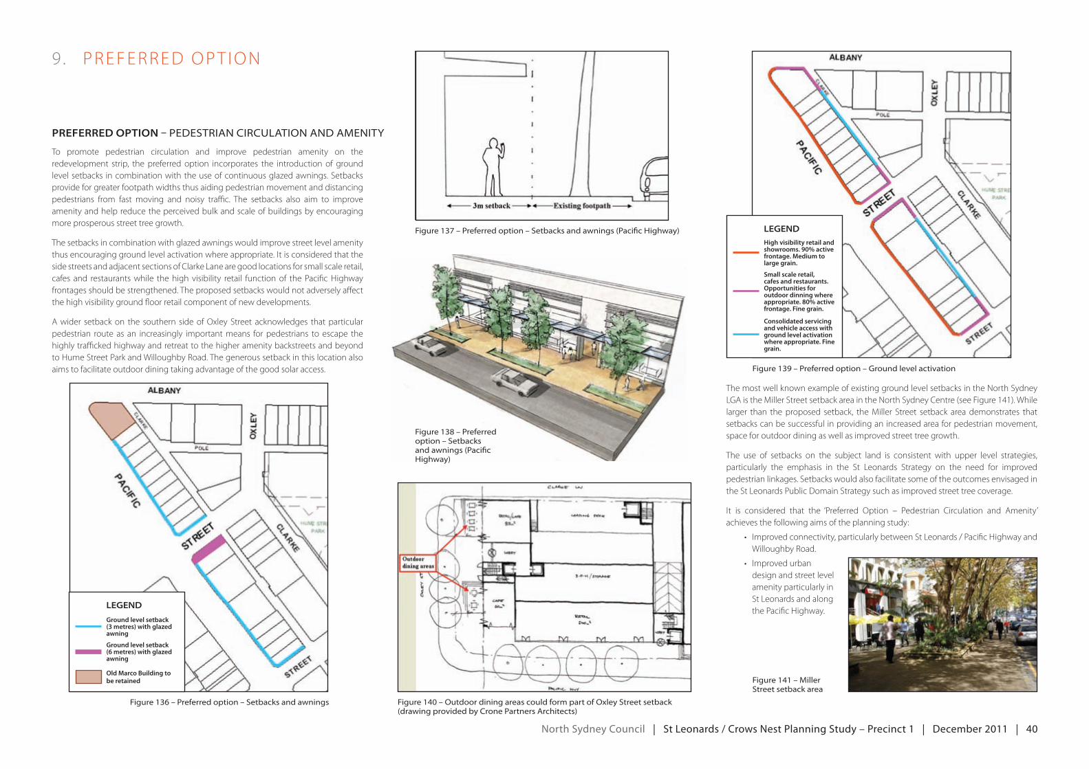
north Sydney council | St Leonards / crows nest planning Study – precinct 1 | december 2011 | 40
To promote pedestrian circulation and improve pedestrian amenity on the redevelopment strip, the preferred option incorporates the introduction of ground level setbacks in combination with the use of continuous glazed awnings. Setbacks provide for greater footpath widths thus aiding pedestrian movement and distancing pedestrians from fast moving and noisy traffic. The setbacks also aim to improve amenity and help reduce the perceived bulk and scale of buildings by encouraging more prosperous street tree growth.
The setbacks in combination with glazed awnings would improve street level amenity thusencouraginggroundlevelactivationwhereappropriate.Itisconsideredthattheside streets and adjacent sections of Clarke Lane are good locations for small scale retail, cafes and restaurants while the high visibility retail function of the Pacific Highway frontages should be strengthened. The proposed setbacks would not adversely affect the high visibility ground floor retail component of new developments.
A wider setback on the southern side of Oxley Street acknowledges that particular pedestrian route as an increasingly important means for pedestrians to escape the highly trafficked highway and retreat to the higher amenity backstreets and beyond to Hume Street Park and Willoughby Road. The generous setback in this location also aims to facilitate outdoor dining taking advantage of the good solar access.
The most well known example of existing ground level setbacks in the North Sydney LgAisthemillerStreetsetbackareaintheNorthSydneyCentre(seeFigure141).whilelarger than theproposed setback, themiller Street setback areademonstrates thatsetbacks can be successful in providing an increased area for pedestrian movement, space for outdoor dining as well as improved street tree growth.
The use of setbacks on the subject land is consistent with upper level strategies, particularly the emphasis in the St Leonards Strategy on the need for improved pedestrian linkages. Setbacks would also facilitate some of the outcomes envisaged in the St Leonards Public Domain Strategy such as improved street tree coverage.
It is considered that the ‘Preferred option – Pedestrian Circulation and Amenity’achieves the following aims of the planning study:
• Improvedconnectivity,particularlybetweenStLeonards/PacificHighwayandWilloughby Road.
• Improvedurbandesign and street level amenity particularly in St Leonards and along the Pacific Highway.
9 . PreFerredoPT IoN
preferred option – peDestrian CirCulation anD amenity
figure 136 – preferred option – setbacks and awnings figure 140 – outdoor dining areas could form part of oxley street setback (drawing provided by Crone partners architects)
Legend
Ground level setback (3 metres) with glazed awning
Ground level setback (6 metres) with glazed awning
Old Marco Building to be retained
figure 137 – preferred option – setbacks and awnings (pacific highway)
figure 138 – preferred option – setbacks and awnings (pacific highway)
figure 139 – preferred option – ground level activation
figure 141 – miller street setback area
LegendHigh visibility retail and showrooms. 90% active frontage. Medium to large grain.
Consolidated servicing and vehicle access with ground level activation where appropriate. Fine grain.
Small scale retail, cafes and restaurants. Opportunities for outdoor dinning where appropriate. 80% active frontage. Fine grain.
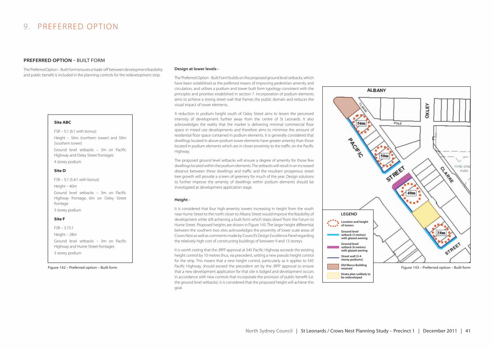
north Sydney council | St Leonards / crows nest planning Study – precinct 1 | december 2011 | 41
9 . PreFerredoPT IoN
preferred option – built form
The‘Preferredoption–builtForm’ensuresa‘trade-off’betweendevelopmentfeasibilityand public benefit is included in the planning controls for the redevelopment strip.
design at lower levels -
The ‘Preferred Option - Built Form’ builds on the proposed ground level setbacks, which have been established as the preferred means of improving pedestrian amenity and circulation, and utilises a podium and tower built form typology consistent with the principlesandprioritiesestablishedinsection7.Incorporationofpodiumelementsaims to achieve a strong street wall that frames the public domain and reduces the visual impact of tower elements.
A reduction in podium height south of Oxley Street aims to lessen the perceived intensity of development further away from the centre of St Leonards. It alsoacknowledges the reality that the market is delivering minimal commercial floor space in mixed use developments and therefore aims to minimise the amount of residentialfloorspacecontainedinpodiumelements.Itisgenerallyconsideredthatdwellings located in above-podium tower elements have greater amenity than those located in podium elements which are in closer proximity to the traffic on the Pacific Highway.
The proposed ground level setbacks will ensure a degree of amenity for those few dwellings located within the podium elements. The setbacks will result in an increased distance between these dwellings and traffic and the resultant prosperous street tree growth will provide a screen of greenery for much of the year. Design solutions to further improve the amenity of dwellings within podium elements should be investigated at development application stage.
height -
It isconsideredthat fourhigh-amenitytowers increasing inheight fromthesouthnear Hume Street to the north closer to Albany Street would improve the feasibility of development while still achieving a built form which ‘steps down’ from the Forum to HumeStreet.ProposedheightsareshowninFigure143.Thelargerheightdifferentialbetween the southern two sites acknowledges the proximity of lower scale areas of Crows Nest as well as comments made by Council’s Design excellence Panel regarding the relatively high cost of constructing buildings of between 9 and 13 storeys.
ItisworthnotingthatthejrPPapprovalat545PacificHighwayexceedstheexistingheightcontrolby10metresthus,viaprecedent,settinganewpseudoheightcontrolfor thestrip.Thismeansthatanewheightcontrol,particularlyas itapplies to545PacificHighway, shouldexceed theprecedent setby the jrPPapproval toensurethat a new development application for that site is lodged and development occurs in accordance with new controls that incorporate the provision of public benefit (i.e. thegroundlevelsetbacks).Itisconsideredthattheproposedheightwillachievethisgoal.
figure 142 – preferred option – built form
Site ABC
FSr–5:1(6:1withbonus)
Height – 56m (northern tower) and 50m(southern tower)
ground level setbacks – 3m on PacificHighway and Oxley Street frontages
4storeypodium
Site D
FSr–5:1(5.4:1withbonus)
Height–40m
ground level setbacks – 3m on PacificHighway frontage, 6m on Oxley Street frontage
3 storey podium
Site F
FSr–3.75:1
Height–28m
ground level setbacks – 3m on PacificHighway and Hume Street frontages
3 storey podium
figure 143 – preferred option – built form
Legend
Old Marco Building retained
Strata plan unlikely to be redeveloped
Location and height of towers
Ground level setback (3 metres) with glazed awning
Ground level setback (6 metres) with glazed awning
Street wall (3-4 storey podiums)
north Sydney council | St Leonards / crows nest planning Study – precinct 1 | december 2011 | 42
9 . PreFerredoPT IoN
preferred option – built form
fSrs -
The use of ‘base’ and ‘bonus’ FSRs has been included to allow for additional trade-offs between development feasibility and public benefit beyond the provision of ground level setbacks in exchange for height.
The ‘base’ FSR control generally aims to ensure that overall floor space is not increased beyond that permitted by current controls. However a small increase in the base FSR forsited(521PacificHighway)isproposedtocompensateforthelargergroundlevelsetback sought for this particular site.
Proposed ‘base’ FSR controls for the 3 redevelopment sites are as follows:
• redevelopmentsiteAbC–FSr5:1
• redevelopmentsited–FSr5:1(4.3:1compliant+0.7:1increase)
• redevelopmentsiteF–FSr3.75:1
Two FSR bonuses are proposed that involve the awarding of additional floor space beyond the ‘base’ FSRs outlined above. ‘Bonus’ FSRs should only be awarded if arrangements are in place to deliver predetermined public benefits.
It isproposed thatdevelopment siteAbCbeeligible for adevelopmentbonusof1:1 (6:1 in total) if arrangements are in place to deliver the open space outcome on the eastern side of Hume Street. The process of developing built form options revealed that only development site ABC is capable of accommodating an amount of additional floor space that would ‘pay’ for the open space outcome while still providinganacceptablebuiltform.TheFSrof6.7:1usedtomodelbuiltformoption3 has been reduced to 6:1 so as to ensure criticisms of that option regarding possible non-compliance with the stepping down principle and excessive podium size can be overcome.
Itisproposedthatdevelopmentsitedbeeligibleforadevelopmentbonusof0.4:1(5.4:1intotal).TheprocessofdevelopingbuiltformoptionsshowedthatdevelopmentsitediscapableofaccommodatinganFSrof5.4:1whilestillprovidinganacceptablebuilt form. However no off-site open space outcomes were identified that could form the basis of an appropriate and feasible trade-off. Other public benefits could be considered that achieve strategic Council objectives beyond those of this planning study,includingtheprovisionofaffordablehousing;ortheprovisionofanewchildcarecentre.Ifanapplicantcandemonstratedemandforthistypeofpublicbenefitand arrangements are in place for delivery, then the development bonus should be awarded.
NodevelopmentbonusisproposedfordevelopmentsiteF.Itisconsideredthatthepreferred option for that site provides for a comfortable transition to the lower scale buildings of the Crows Nest Town Centre.
The introduction of bonus provisions acknowledges the high degree of uncertainty regarding the commercial and technical feasibility of delivering the predetermined public benefits as part of redevelopment on the PacificHighway. It is considered
that property owners should be free to pursue redevelopment using the ‘base’ FSR without uncertainty regarding the provision of public benefit being built into mandatory controls. However, if property owners find that the bonus mechanism provides sufficient commercial benefit then the trade-off should be permitted.
Feasibility - Council engaged property consultants to undertake a feasibility study of the preferred option to see whether the project would be economically feasible. A profit/riskmarginof20%wasassumedtoresultinahighlikelihoodofredevelopmentoccurring. It was found that the profit/riskmargin for development site AbCwasaround 20%, however, that the feasibility does not include the purchase of landidentified for new open space. When this additional cost is included, the profit/risk marginisreducedtoaround17%.
developmentsitesdwas foundtohaveaprofit riskmarginof21%.Thepreferredoption for development site F closely resembles that of option 2 which was found to haveaprofit/riskmarginof18%howeveraproposedfurtherincreaseinheightmayrender redevelopment likely.
Itisnotedthatsuchmarginsmayvarydependingonthecircumstancesofindividualproperty owners and developers and feasibility study outcomes should be used as a guide only.
The‘Preferredoption–builtForm’attemptstoprovideanincreaseinheightandfloorspace that:
• ‘pays’fortheprovisionofthegroundlevelsetbacks;
• ‘pays’fortheprovisionofnewopenspaceontheeasternsideofHumeStreetwithapedestrianlinktowilloughbyroad;
• respectsthesteppingdownprinciple;and
• encourages545PacificHighwaytolodgeanewdAinaccordancewithnewcontrols (regardless of whether the bonus provision is utilised).
It is considered that the ‘Preferred option – built Form’ in combination with theproposed ground level setbacks will achieve the following aims of the planning study:
• IncreasedinvestmentinStLeonardsanddecreasedcommercialvacancyrates,with particular focus on the rejuvenation of the Pacific Highway between St Leonards train station and the intersection of Pacific Highway and Willoughby Road.
• ImprovedbuildingdesignandresidentialamenityinStLeonards.
north Sydney council | St Leonards / crows nest planning Study – precinct 1 | december 2011 | 43
9 . PreFerredoPT IoN
preferred option – built form
figure 144 – preferred option built form – indicative elevation
figure 145 – preferred option built form block modelling
figure 146 – preferred option built form block modelling
figure 147 – preferred option built form block modelling
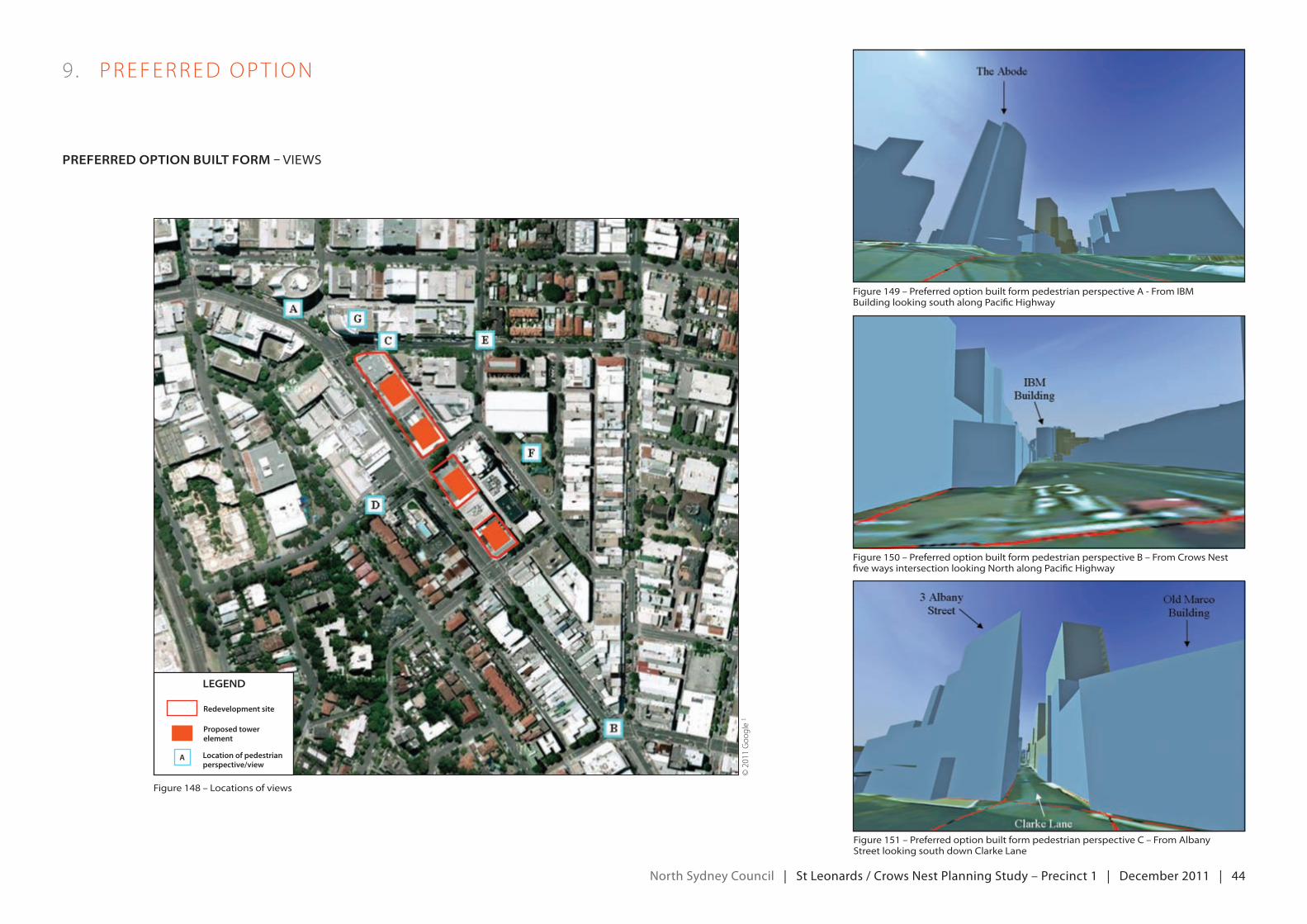
north Sydney council | St Leonards / crows nest planning Study – precinct 1 | december 2011 | 44
9 . PreFerredoPT IoN
preferred option BuiLt form – views
figure 148 – locations of views
figure 149 – preferred option built form pedestrian perspective a - from ibm building looking south along pacific highway
figure 150 – preferred option built form pedestrian perspective b – from Crows nest five ways intersection looking north along pacific highway
figure 151 – preferred option built form pedestrian perspective C – from albany street looking south down Clarke lane
©2011goo
gle
1
Legend
Location of pedestrian perspective/view
Redevelopment site
Proposed tower element
A

north Sydney council | St Leonards / crows nest planning Study – precinct 1 | december 2011 | 45
9 . PreFerredoPT IoN
preferred option BuiLt form – views
figure 152 – preferred option built form pedestrian perspective D – from oxley street near intersection with nicholson street figure 154 – preferred option built form pedestrian perspective f – from hume street park
figure 153 – preferred option built form pedestrian perspective e – from intersection of albany street and oxley street figure 155 – preferred option built form view g – from the abode building
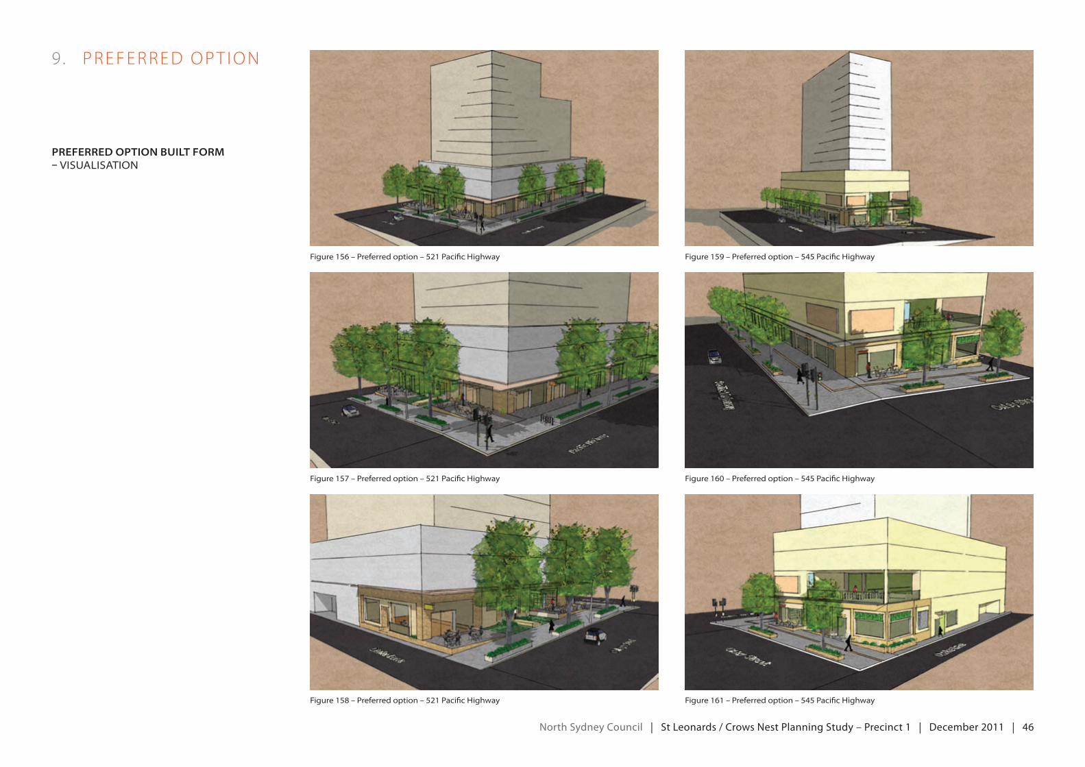
north Sydney council | St Leonards / crows nest planning Study – precinct 1 | december 2011 | 46
9 . PreFerredoPT IoN
preferred option BuiLt form – visualisation
figure 156 – preferred option – 521 pacific highway figure 159 – preferred option – 545 pacific highway
figure 157 – preferred option – 521 pacific highway figure 160 – preferred option – 545 pacific highway
figure 158 – preferred option – 521 pacific highway figure 161 – preferred option – 545 pacific highway
north Sydney council | St Leonards / crows nest planning Study – precinct 1 | december 2011 | 47
ImplementationofthepreferredoptionrequiresCouncilto:
• Changelocalplanningprovisions;and
• undertakefurtherplanningstudyworktofacilitatetheopenspacecomponentofthepreferredoption.
chAngeS to LocAL pLAnning proviSionS
AplanningproposalshouldbepreparedandsubmittedtothedepartmentofPlanningandInfrastructureoutliningtheproposedchanges to North Sydney Council’s Local environmental Plan (LeP) and Development Control Plan (DCP). Where a change is not stipulated, existing provisions are to remain unchanged (e.g. above podium setbacks). Proposed LeP and DCP changes are as follows:
lep
IntroducethefollowingFSrcontrolstotheredevelopmentstrip:
• AbC–5:1
• d–5:1
• F–3.75:1
Revise existing height controls:
• AbC–56m(northerntower)and50m (southern tower)
• d–40m
• F–28m
Insert a new local ormiscellaneous provision regarding ground level setbacks on the redevelopment strip. In particular, toprohibit buildings or parts of buildings being erected above existing ground level within the specified setback areas (that is, 3m onfrontagesfacingthePacificHighway,onthenorthernsideofoxleyStreetandonthenorthernsideofHumeStreet;and6mon the southern side of Oxley Street).
Introducesitespecificprovisionsthatfacilitateabonusmechanism.Forexample:
• AbC–FSrbonusof1:1maybeawardedifsatisfactoryarrangementsareinplacefortheprovisionof920m²ofnewopenspace on the eastern side of Hume Street with a pedestrian link to Willoughby Road.
• d–FSrbonusof0.4:1maybeawardedifsatisfactoryarrangementsareinplacefortheprovisionofapublicbenefit,thedemand for which is demonstrated by the applicant to the satisfaction of Council.
Siteamalgamationorminimumsiteareacontrolsmayalsoberequired.
DCp
reviserequiredpodiumheightsinAreaCharacterStatement:
• d–3storeys
• F–3storeys
further pLAnning Study work
The closure of Hume Street and the conversion of Clarke Street into a lower order thoroughfare involves Council owned land and their feasibility should be pursued as a priority. For example, appropriate management of local traffic and parking implications will needtobeinvestigated.Fundingsourcesalsoneedtobeinvestigatedincludingthepossibilityofusingcurrentandfutures94income to expand and embellish the park.
FurtherplanningstudyworkwithinPrecinct1willberequiredtoinvestigatehowachildcarecentrecouldbeestablishedontheeastern side of Hume Street thus allowing Kelly’s Place child care to be relocated. Prior to any relocation occurring, and in order to maintain or improve the existing child care service level, any new facility will need to have similar or improved amenity and be capable of accommodating a similar or greater number of child care places.
InvestigationsshouldalsoconsiderhowpropertiesontheeasternsideofHumeStreetcanberedevelopedsoastopositivelycontribute to an expanded Hume Street Park.
Should the bonus FSR mechanism proposed by this study not be utilised by property owners, alternate means to achieve new openspaceandapedestrianlinktowilloughbyroad,asenvisagedbythePreferredoption–openSpace,willalsoneedtobeinvestigated.
10 . ImPLemeNTAT IoN
north Sydney council | St Leonards / crows nest planning Study – precinct 1 | december 2011 | 48
AeriAL photogrAphy copyright
1.Aerialphotography-©2011google–Imagery©2011Cnes/Spot Image, digital globe, geoeye, Sinclairknightmerz
2. This study incorporates Data which is ©Commonwealth ofAustralia2008.Thedatahasbeenusedinthestudywith the permission of the Commonwealth. The Commonwealth has not evaluated the Data as altered and incorporated within the study, and therefore gives no warranty regarding its accuracy, completeness, currency or suitability for any particular purpose.