Embed Size (px)
Citation preview
SSCI 301L -‐ Maps and Spatial Reasoning Units: 4 Term, Day, Time: Fall 2015, Tuesdays, Thursdays, 2:00 -‐
3:20 p.m. Location: SOS B44 lectures; AHF B57A labs Instructor: Dr. Elisabeth Sedano Office: AHF B57C Office Hours: Mondays, 2:00 -‐ 3:00 p.m, Wednesdays
12:00 – 1:00 p.m., and available other times by appointment.
Contact Info: [email protected] Twitter: @lisasedano Library Help: Katharin Peter Office: VKC B40A Office Hours: By appointment. Contact Info: [email protected], 213-‐740-‐1700 IT Help: Richard Tsung Hours of Service: Mon.-‐Fri. 9 a.m. – 5 p.m. PT Contact Info: [email protected], 213-‐821-‐4415
Course Description Maps have long played a role in the production and use of geographic information. They support many different kinds and levels of spatial reasoning ranging from simple queries (route finding, proximity analysis) to more advanced forms of spatial analysis and modeling. There has been a recent explosion in geographic information (GI) technologies the past two decades which include quick visualization tools (Google, Bing Maps) to sophisticated GISystems (ArcGIS, Idrisi) and many kinds of GPS-‐enabled sensors. These tools have attracted large numbers of users: for example, social workers use GIS to track where clients live and where more social services are needed, planners use GIS to analyze the transformation of city spaces as urban areas develop, landscape architects use GIS to design and track the status of their individual project sites, anthropologists use GIS to map the changing cultural patterns of a neighborhood, historians use GIS to map historical transformation across space, environmental scientists use GIS to track how natural disasters and groundwater flows interact with human-‐environment systems, and emergency responders use GIS to track where earthquake or hurricane survivors need assistance.
Syllabus for SSCI 301, Page 2 of 8
The labs will examine the Los Angeles River through a spatial lens and use GIS to compile, organize, analyze, and share spatial knowledge of the river and the communities it flows from the west end of the San Fernando to the ocean in Long Beach.
Taken as a whole, this course provides a broad understanding (theoretical and technical) for later work with geographic information, regardless of background. It covers the geographic information technologies and spatial skills needed to map, model, and predict how physical and social phenomena develop and change. In these ways, the spatial sciences can significantly affect the way research is conducted, profoundly impact the way we understand the world, and help us to prepare plans and designs that would dramatically improve the quality of life for those whose life experiences and prospects are shaped by spatial processes if implemented.
Learning Objectives Students who excel in SSCI 301L will be able to:
• Explain how and why organizations (i.e., public, private, and not-‐for-‐profits) produce and use geographic data, including topographic maps, remotely sensed imagery, and thematic maps to portray census and various types of community, social, and natural resource information;
• Explain how modern geographic analysis and visualization tools can be used to advance our knowledge and understanding of human and environmental activities and events from a variety of disciplinary perspectives;
• Describe the goals and contents of key geographic applications such as Bing maps, Google Earth, MapQuest, OpenStreetMap, and the U.S. National Map.
Prerequisite(s): None Co-‐Requisite (s): None Concurrent Enrollment: None Recommended Preparation: None
Course Structure This is a four-‐credit course comprised of lectures (two per week) and lab (one per week). The lecture sessions will discuss various aspects of cartography, spatial reasoning, and the hardware and software systems used to investigate these processes. The weekly lab meetings are designed to introduce you to the tools of scientific inquiry and to give you practical experience in implementing these tools to explore various problems within the framework of the scientific method. The lecture and lab sessions are designed to complement each other to provide you with sound theoretical reasoning and the technical skills to investigate various physical and/or social processes. Your weekly laboratory assignments will be graded and returned, and the mid-‐
Syllabus for SSCI 301, Page 3 of 8
term and final exams will have a laboratory component to them. It is required that you register for both the lecture and laboratory session for this course. Please note that all course materials and correspondence will be posted on the course Blackboard site. As a registered student you will find this course available for you to access at 10 a.m. Pacific Time on the first day of classes.
Course Assessment The table below summarizes the SSCI 301 course assessments and their value towards your final grade in the course:
Assessment Points % of Grade In-‐Class Assignments 50 10 Social Media Interaction 30 10 Laboratory Assignments 100 25 Laboratory Practical 50 15 Mid-‐term Examination 100 20 Final Project 100 20 TOTAL 100
Social Media – Twitter The social media site Twitter has been gaining tremendous currency in the academic world as an instrument for sharing information, commenting on issues related to higher education, as well as addressing challenges in a given field, such as geospatial technologies. As such, it has achieved acclaim for its use as a pedagogical tool to extend the work of the classroom. We are going to use Twitter in this course to complement assignments and activities, in addition to augmenting the analytical work of the class. Beyond its relevance to the coursework, though, you are encouraged to explore the site as to its possibilities for professional networking for yourselves. Make sure to follow me (@lisasedano), other members of the class, in addition to following leaders in your field.
Although we will sometimes use Twitter in the classroom, the bulk of your Twitter activity will take place outside of class. You will be required to tweet a minimum of 2 times per week (at least two tweets each week for weeks 1-‐15 of this course). There are a few simple guidelines for tweeting: (1) they must be relevant to the class (i.e., a response to a reading, a link to a related article, a map or image, a question, etc.); (2) they must be substantive; and (3) they
Syllabus for SSCI 301, Page 4 of 8
must be respectful. In addition to reading your tweets on a regular basis, I will be using an online archiving tool to keep track of Twitter activity.
You must use the hashtag #SSCI301 to ensure that your tweets are incorporated into the class discussion. Any tweets that do not contain this hashtag will not be counted because the website will not record their activity.
Twitter activity for the course will be graded on a pass/fail basis. If you tweet the requisite number of times (a minimum of two tweets per week – or 2X15 = 30 total tweets), you will receive full credit for this assignment. If not, then you will receive partial credit commensurate with the number of weeks in which you tweeted the required number of times.
Required Readings The required textbooks for this course are:
• Harder C, Ormsby T, and Balstrom T 2013 Understanding GIS: An ArcGIS Project Workbook (Second Edition). Redlands, CA, Esri Press
• Harvey F 2008 A Primer of GIS: Fundamental Geographic and Cartographic Concepts (First Edition). New York, Guilford Press
• Monmonier M 1996 How to Lie with Maps (Second Edition). Chicago, University of Chicago Press
Syllabus for SSCI 301, Page 5 of 8
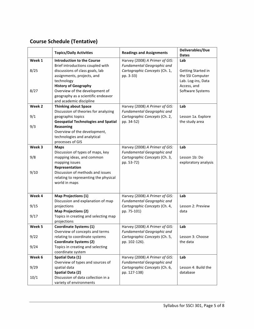
Course Schedule (Tentative)
Topics/Daily Activities Readings and Assignments Deliverables/Due Dates
Week 1 8/25 8/27
Introduction to the Course Brief introductions coupled with discussions of class goals, lab assignments, projects, and technology History of Geography Overview of the development of geography as a scientific endeavor and academic discipline
Harvey (2008) A Primer of GIS: Fundamental Geographic and Cartographic Concepts (Ch. 1, pp. 3-‐33)
Lab Getting Started in the SSI Computer Lab. Log-‐ins, Data Access, and Software Systems
Week 2 9/1 9/3
Thinking about Space Discussion of theories for analyzing geographic topics Geospatial Technologies and Spatial Reasoning Overview of the development, technologies and analytical processes of GIS
Harvey (2008) A Primer of GIS: Fundamental Geographic and Cartographic Concepts (Ch. 2, pp. 34-‐52)
Lab Lesson 1a. Explore the study area
Week 3 9/8 9/10
Maps Discussion of types of maps, key mapping ideas, and common mapping issues Representation Discussion of methods and issues relating to representing the physical world in maps
Harvey (2008) A Primer of GIS: Fundamental Geographic and Cartographic Concepts (Ch. 3, pp. 53-‐72)
Lab Lesson 1b: Do exploratory analysis
Week 4 9/15 9/17
Map Projections (1) Discussion and explanation of map projections Map Projections (2) Topics in creating and selecting map projections
Harvey (2008) A Primer of GIS: Fundamental Geographic and Cartographic Concepts (Ch. 4, pp. 75-‐101)
Lab Lesson 2: Preview data
Week 5 9/22 9/24
Coordinate Systems (1) Overview of concepts and terms relating to coordinate systems Coordinate Systems (2) Topics in creating and selecting coordinate system
Harvey (2008) A Primer of GIS: Fundamental Geographic and Cartographic Concepts (Ch. 5, pp. 102-‐126).
Lab Lesson 3: Choose the data
Week 6 9/29 10/1
Spatial Data (1) Overview of types and sources of spatial data Spatial Data (2) Discussion of data collection in a variety of environments
Harvey (2008) A Primer of GIS: Fundamental Geographic and Cartographic Concepts (Ch. 6, pp. 127-‐138)
Lab Lesson 4: Build the database
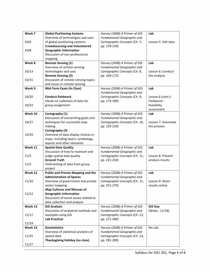
Syllabus for SSCI 301, Page 6 of 8
Week 7 10/6 10/8
Global Positioning Systems Overview of technologies and uses of global positioning systems Crowdsourcing and Volunteered Geographic Information Discussion of non-‐professional mapping
Harvey (2008) A Primer of GIS: Fundamental Geographic and Cartographic Concepts (Ch. 7, pp. 139-‐159)
Lab Lesson 5: Edit data
Week 8 10/13 10/15
Remote Sensing (1) Overview of remote sensing technologies and uses Remote Sensing (2) Discussion of remote sensing topics and issues in remote sensing
Harvey (2008) A Primer of GIS: Fundamental Geographic and Cartographic Concepts (Ch. 8, pp. 160-‐173)
Lab Lesson 6: Conduct the analysis
Week 9 10/20 10/22
Mid-‐Term Exam (In Class) Conduct fieldwork Hands-‐on collection of data for group assignment
Harvey (2008) A Primer of GIS: Fundamental Geographic and Cartographic Concepts (Ch. 9, pp. 174-‐189)
Lab Lesson 6 (cont.): Fieldwork– feasibility assessment
Week 10 10/27 10/29
Cartography (1) Discussion of overarching goals and techniques for successful map-‐making Cartography (2) Overview of data display choices in maps, including layers, symbology, layouts and other elements
Harvey (2008) A Primer of GIS: Fundamental Geographic and Cartographic Concepts (Ch. 10, pp. 193-‐220)
Lab Lesson 7: Automate the process
Week 11 11/3 11/5
Spatial Data Quality Discussion of how to maintain and judge spatial data quality Ground Truth Field-‐testing of data from group project
Harvey (2008) A Primer of GIS: Fundamental Geographic and Cartographic Concepts (Ch. 11, pp. 221-‐250)
Lab Lesson 8: Present analysis results
Week 12 11/10 11/12
Public and Private Mapping and the Administration of Spaces Overview of government and private sector mapping Map Cultures and Misuses of Geographic Information Discussion of social issues related to data collection and analysis
Harvey (2008) A Primer of GIS: Fundamental Geographic and Cartographic Concepts (Ch. 12, pp. 251-‐270)
Lab Lesson 9: Share results online
Week 13 11/17 11/19
GIS Analysis Discussion of analytical methods and examples using GIS Lab Practical
Harvey (2008) A Primer of GIS: Fundamental Geographic and Cartographic Concepts (Ch. 13, pp. 271-‐280)
GIS Day (Weds., 11/18)
Week 14 11/25 11/27
Geostatistics Overview of statistical analytics of spatial data Thanksgiving Holiday (no class)
Harvey (2008) A Primer of GIS: Fundamental Geographic and Cartographic Concepts (Ch. 14, pp. 281-‐289)
No Lab
Syllabus for SSCI 301, Page 7 of 8
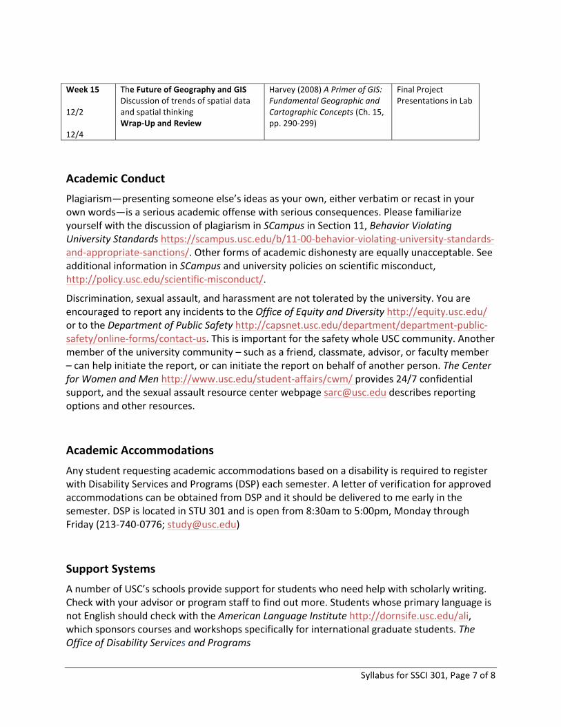
Week 15 12/2 12/4
The Future of Geography and GIS Discussion of trends of spatial data and spatial thinking Wrap-‐Up and Review
Harvey (2008) A Primer of GIS: Fundamental Geographic and Cartographic Concepts (Ch. 15, pp. 290-‐299)
Final Project Presentations in Lab
Academic Conduct Plagiarism—presenting someone else’s ideas as your own, either verbatim or recast in your own words—is a serious academic offense with serious consequences. Please familiarize yourself with the discussion of plagiarism in SCampus in Section 11, Behavior Violating University Standards https://scampus.usc.edu/b/11-‐00-‐behavior-‐violating-‐university-‐standards-‐and-‐appropriate-‐sanctions/. Other forms of academic dishonesty are equally unacceptable. See additional information in SCampus and university policies on scientific misconduct, http://policy.usc.edu/scientific-‐misconduct/.
Discrimination, sexual assault, and harassment are not tolerated by the university. You are encouraged to report any incidents to the Office of Equity and Diversity http://equity.usc.edu/ or to the Department of Public Safety http://capsnet.usc.edu/department/department-‐public-‐safety/online-‐forms/contact-‐us. This is important for the safety whole USC community. Another member of the university community – such as a friend, classmate, advisor, or faculty member – can help initiate the report, or can initiate the report on behalf of another person. The Center for Women and Men http://www.usc.edu/student-‐affairs/cwm/ provides 24/7 confidential support, and the sexual assault resource center webpage [email protected] describes reporting options and other resources.
Academic Accommodations Any student requesting academic accommodations based on a disability is required to register with Disability Services and Programs (DSP) each semester. A letter of verification for approved accommodations can be obtained from DSP and it should be delivered to me early in the semester. DSP is located in STU 301 and is open from 8:30am to 5:00pm, Monday through Friday (213-‐740-‐0776; [email protected])
Support Systems A number of USC’s schools provide support for students who need help with scholarly writing. Check with your advisor or program staff to find out more. Students whose primary language is not English should check with the American Language Institute http://dornsife.usc.edu/ali, which sponsors courses and workshops specifically for international graduate students. The Office of Disability Services and Programs

Syllabus for SSCI 301, Page 8 of 8
http://sait.usc.edu/academicsupport/centerprograms/dsp/home_index.html provides certification for students with disabilities and helps arrange the relevant accommodations. If an officially declared emergency makes travel to campus infeasible, USC Emergency Information http://emergency.usc.edu/ will provide safety and other updates, including ways in which instruction will be continued by means of blackboard, teleconferencing, and other technology.